oil and gas exploration in washington - wa - … oil and gas exploration in washington. a washington...
TRANSCRIPT

State of Washington ALBERT D. ROSELLINI, Governor
Department of Conservation EARL COE, Director
DIVISION OF MINES AND GEOLOGY MARSHALL T. HUNTTING, Supervisor
Information Circular No. 29
OIL AND GAS EXPLORATION
IN WASHINGTON
1900-1957
By
VAUGHN E. LIVINGSTON, Jr.
STATE PRINTING PLANT, OLYMPIA, WASHINGTON
1958
For sale by Department of Conservation, Olympia, Washington. Price 75 cents.
CONTENTS
Introduction ........................................................ Page
1
Past exploration•••••••••••••••••••••••••••••••••••••••••••••••••••• 1
Rattlesnake Hills gas field, Benton County ••••••••••••••• • •• • • • 3
Whatcom County gas field • • • . • • • • • . • • • • • • • • • • • • • • • • • • • • • • • • • • • • 4
............................................ Black Diamond area
Ocean City field ............................................... Other areas in Grays Harbor County .......................... Forks-Hoh River area .........................................
Conclusions ........................................................
5
6
8
9
9
Explanation of exploration data • • • • • • • • • • • • • • • • • • • • • • • • • • • • • • • • • • • • • 10
Asotin County
Benton County
Chelan County
......................................................
......................................................
...................................................... ..................................................... ..................................................... .....................................................
Clallam County
Cowlitz County
Douglas County
Grant County .......................................................
11
11
13
14
18
18
18
Grays Harbor County . . . • . . . . . . . . . . . . . . . . . . . . . . . . . . . . . . • • . . . . . . . • . . . 18
Island Co.unty . . . . . • . . • . . . . . . . . . . . . . . . . • . . . • . . . . • . • . . • . . . . • . • . . . . • • . . 26
Jefferson County ••••••••••••••••••••••••••••••••••••••••••••••••••• 26
King County . . . . . . . . . . . . . . . . . . . . . . . . . . . . . . • . . . . . . . . . . . . . . . . . . . • . . • . . 28
Kitsap County . . . . • . . • . . . . . • . . . . • . . . . • . . . . . . . . • . . . . . . . • . . . • • . . . . . . . . 29
Kittitas County . . . . . . . . . . . • • . . . . • . . . . . . . . • . . . • . . . . . . . . . . . . . . . . . . . .. • . 30

Klickitat County ......••..••••.•.......•.••••.••••...••...•.•..•... 30
Lewis County . . . . • . . • . . • . . . . . • . • • . • • . • . • • • . • • • • . . . . • . . . • . • . . • • . . • • • 31
Mason County . . . • . . . . • . . . • . • . • . • • • . • • . . . • . • • . . . • . . • . . . . . . • • . . • • . . . . 35
Pacific County ........•..•...•....•.....•.....•.•..•.........•.•.. •. 36
Pierce County . . . . . . . . . . . . . . . . • . . . . . . . . . . . . . . . . . . • • • . . • • • • • . • . . • . . . . 39
San Juan County . . . . . . . . . . . . • . • . . • . . . . . . • . . . . . . . . . . . . . • . • . • • • . . • • . • • 39
Skagit County ...................................................... 40
Skamania County . . . . . . . . . . . . . . .. . . . . . . . . . . . . . . . . . . . • . . . . . . . . . . . . . . . . 40
Snohomish Coun'ty . • .. · • • • •. •. • .. • ·. • • ... • · • · • •. · • • • • · • • • •. • • • • • • · · • 40
Spokane County . ~ ...•.........• · .....•..•.. · ................ • .. · . • . 41
Stevens County ..................................................... Thurs ton C aunty .................. . . . . . . . . . . . . . . . . . . . . . . . . . . . . . . . . . . Wahkiakum County .................................................
42
42
44
Walla Walla County • • • • • • • • • • • • • • • • • • • • • • • • • • • • • • • • • • • • • • • • • • • • • • • • • "44
..................................................... .....................................................
Whatcom County
Yakima County
Bibliography .......................................................
ILLUSTRATIONS
44
51
53
Plate 1. Dry hole map of Washington ••••••••••••••••••••••• In pocket
1
OIL AND GAS EXPLORATION IN WASHINGTON
1900-1957
By Vaughn E. Livingston, Jr.
Introduction
In recent years there has been an increasing interest in the history of oil and gas exploration in Washington. A Washington Division of Mines and Geology report (Glover, 194 7) on this subject has been out of print for several years. The need for revising this report and bringing it up to date was emphasized in the summer of 1957 during the period of high interest in oil in Washington aroused by the J. W. Tanner, Sunshine Mining Company, et al. - Medina No. 1 well. The purpose of the present publication is to re-present the information given in Information Circular 15 (Glover, 194 7) and its supplement (printed in 1953), along with data gathered since 1953. Included with this report is a dry-hole map showing the locations of wells deeper than 500 feet.
In collecting data since 1953, the greatest aid has been the .. Oil and Gas Conservation Act, Chapter 146 (RCW 78.52.001 to 78.52.550) passed by the 32nd Washington Legislature in 1951. This act set up an Oil and Gas Conservation Committee with authority to adopt rules and regulations to govern drilling in Washington. This committee, consisting of the governor, land commissioner, director of conservation, state auditor, and state treasurer, on January 18, 1954, adopted the necessary rules and regulations to carry out some of the provisions of the act. Among other things these rules require that all logs, histories, and records of tests be filed with the Oil and Gas Supervisor (who is the Supervisor of the Division of Mines and Geology} upon completion or abandonment of a well. As a result of this new law and through the cooperation of the oil companies, both major and independent, in turning in well data, there is available to the public a fairly complete file on oil exploration in Washington since 1954 •.
Past exploration
Oil was first reported in Washington about 1883 along the Pacific Ocean beach on the west side of the Olympic Peninsula, where there are outcrops of sandy shales with a kerosene odor (the "smell muds" of the Indians). At certain times of the year and at certain places, small amounts of 37- to 40-gravity paraffin base oil seep from the outcrop. In this same general area, gas mounds which look similar to mud volcanoes have been
'formed where mud and water bubbling to the surface with wet petroleum gas have built up mud cores.

2
The first known oil test in Washington was drilled by Mr. John E. McManus between 1900 and 1902, either near Stanwood Station or at Machias, Snohomish County. This well was abandoned at a depth of between 800 and 900 feet because of mechanical difficulties. One of the earliest indications that gas occurred in the state was found by chance in Whatcom County in 1893. A man named Clark is reported to have struck a match to light his pipe while digging a water well. Gas that had seeped into the well was ignited by his match, causing an explosion. The occurrence of gas stimulated drilling near the Clark water well, but results were apparently disappointing, because the test well was abandoned.
From this beginning, drilling has been more or less cyclic in Washington, with periods of high and low activity. The peak year was 1930, when 27 wells were drilled in the state. This increased interest probably was the result of the Rattlesnake Hills gas field being put on production the year before.
There have been approximately 323 wells drilled for oil and gas in the state as of January 1958. Of this number, 42 were drilled by major oil companies. Fifty-eight of the wells were drilled east of the Cascade Range. Counties in which the most drilling has been done are: Whatcom, with 87 wells; Grays Harbor, with 45; Benton, with 31; and Jefferson, with 20 wells. Twenty-three other counties have at one time or another had at least one oil test drilled within their borders.
Prior to 1940 very few wells were drilled as the result of sound geologic investigation. Many wells, especially on the west side of the Olympic Peninsula, were drilled on the strength of nearby oil or gas seeps. The great majority of the early wells, however, were drilled at sites selected by unscientific methods of exploration, and some of the wells were part of out-and-out stock swindles.
During the 1940 1 s, interest in Washington as a possible oil-producing state started to increase. An influx into the state of well-financed oil companies with their more accurate methods of keeping records began to add materially to stratigraphic knowledge. In 1949 a good oil and gas show encountered in a well at Ocean City stimulated further exploration. Two other promising wells drilled in this same area caused accelerated activity again in 1 9 5 2 and 1 9 5 7 •
Core hole and seismic programs have been undertaken by several oil companies in v,estern Washington. The counties that have received the most attention are Clallam, Grays Harbor, Lewis, Pacific, and Thurston. The Federal Government and several private companies have made magnetometer and gravity meter surveys over much of western Washington.
There are, of course, certain areas in the state that for one reason or another have been explored more thoroughly than others. This does not mean, however, that these are the only promising areas. Most of the wells were drilled because of nearby oil or gas seeps or as the result of accidental discovery of gas or oil shows in water wells. The areas that have received the most extensive drilling in the past will be described very briefly below.
3
Rattlesnake Hills gas field, Benton County
The Rattlesnake Hills gas field is located in Benton County on the north flank of the Rattlesnake Hills, about 18 miles due northeast of Grandview and 16 miles west of the Columbia River. (See inset F on plate 1.)
The peculiar occurrence of gas in porous basalt flows is an unusual feature of the field. Production came from two zones at depths of approximately 700 and 1,200 feet. The gas was a high-methane type and had none of the heavier fractions that are commonly found associated with a petroleum-derived gas.
The only sedimentary rock exposed in the area is the Ellensburg formation, of probable Miocene-Pliocene age. This is a continental sandstone that rests on the Columbia River basalts. Flows interbedded with the Ellensburg formation have been called Wenas basalt.
The most prominent formation in the area is the Columbia River basalt, which is known to be over 3,600 feet thick in the Rattlesnake Hills. A well, Conservative No. 1, drilled by the Northwestern Natural Gas Corp., went to that depth without reaching the base of the Miocene flows. Near Yakima a well, Miocene Petroleum Co. - Union Gap, was drilled to 3,810 feet without reaching the base of the basalt. There is about 3,000 feet of basalt above the Eagle Creek formation in the Columbia River Gorge, and in the John Day area of Oregon about 6,000 feet of basalt has been measured along the upturned flows.
During the time this report was being prepared (January 1958), Standard Oil Company of California abandoned their Rattlesnake Unit No. 1 well (SE\ sec. 15, T. 11 N., R. 24 E.) at 8,418 feet. The bottom was reported to be in volcanic rock, but no information was available that would indicate whether it was Columbia River basalt or older flows.
The structure of the area is a large northwest-trending faulted asymmetrical anticline, the steep limb being on the northeast. The fault is essentially parallel to and follows along the anticlinal axis for a short distance. It is downthrown to the northeast. The structure of the Rattlesnake Hills anticline is discussed by A. A. Hammer ( 1934).
The source of the gas in this field is unknown. One theory is that the gas originated as the result of decay of vegetable matter in interbasalt sediments or even in the overlying Ellensburg formation. Another theory is that the gas originated in the Roslyn formation, a sandstone with coal measures that crops out about 80 miles north we st of the Rattle snake Hills field, and which may be below the basalt in this area. The gas probably migrated along fractures and accumulated in the vesicular basalt reservoir rock.
The initial discovery of this field was made in 1913, when a well was drilled for water on the northeast limb of the Rattlesnake Hills anticline. This well, later called the Walla Walla No. I, encountered gas at 705 feet.

4
The maximum pressure at the time of discovery was 7 p. s. i. A great deal of gas was wasted by allowing several wells to flow uncontrolled into the air, so that by 1929, when the field was put on commercial production, the pressure had been reduced to 2 p.s.i. Hammer (1934) noted that the pressure fluctuated with the season and amount of rainfall, being greatest in the winter and after rain storms. By 1933 the pressure had decreased to zero and a central compressor plant was built to maintain a vacuum on the field. In 1936 there was an approximate 7-pound vacuum on the field •.
Gas production started in 1929, when 770 Mcf were sold, and in::reased to a high of 2,000 Mcf in 1935. At one time 16 wells were in production. The gas was piped to seven lower Yakima Valley cities during the field's productive period. Output gradually declined until production ceased in September of 1941.
A composite sample taken from the Grandview pipeline gave the following analysis:
Methane ••••••••••••••••••••. 99.35% Nitrogen ..................... 0.65% Specific gravity ••••••••••••••• 0. 559 (calculated) B. t. u., gross................ 1002 (calculated)
Whatcom County gas field
The Whatcom County gas field is located about 5 miles northwest of Bellingham. It is about a quarter of a mile west of the North Bellingham school between U. S. Highway 99 and the Northwest Road. (See insets A and B on plate 1.)
Like the Rattlesnake Hills gas field, this gas field is unusual. The gas is found at shallow depths in glacial debris.
Underlying the glacial material is upper Cretaceous (?) - lower Eocene Chuckanut formation. This is primarily a amtinental sandstone-shale formation that contains some coal measures. Two stratigraphic sections measured by Glover ( 1935, p. 15-23) show the Chuckanut to be approximately 9,000 feet thick.
The rocks underlying the Chuckanut formation in the vicinity of the gas field are unknown. Farther to the south, near Bellingham, the Pelican Dome No. 1, a well drilled in 1938 by Peoples Gas and Oil Development Co., Pelican Petroleum Co., and Northern Oil Co., encountered metamorphic rock (schist) at 5,385 feet. Cretaceous fossiliferous marine elastics outcrop in the San Juan Islands just west and south of the Whatcom County gas field. Either of these formations may underlie the Chuckanut in the northwestern part of Whatcom County.

Overlying the older rocks are heterogeneous unconsolidated glacial drift and fairly well sorted fossiliferous glaciomarine Pleistocene deposits. The glacial drift has a maximum recorded thickness of 615 feet.
The bedrock structure of the area is hidden by the overlying glacial drift.
5
The gas in this field is in Pleistocene sediments, but it was probably generated in the coal measures of the underlying truncated Chuckanut formation and migrated up into the glacial sand lenses.
Production from this field has been from shallow depths. The gas horizons in most of the wells have been at depths of less than 500 feet, and commonly at about 170 feet. The gas has a high methane-nitrogen content. It has not been used commercially but has been piped into homes and farm buildings for domestic use.
Black Diamond area
The Black Diamond area is located about 20 miles south and slightly east of S~attle in southern King County. (See inset C on plate 1.) The discovery of gas and oil in this area was quite by chance. In 1911 Mr. Eugene Lawson was drilling a coal test in the S~SE\ sec. 27, (21-6E) !J near Black Diamond. Gas was first encountered between 900 and 1,000 feet and gradually increased as more carbonaceous shales and coal beds were cut, until at 1,403 feet the pressure had built up to approximately 600 p.s.i. The first confirmed report of an oil show in the area came from the WashingtonCalifornia Oil & Gas Co., Sound Cities Gas & Oil Co., Inc. - Bobb No. 1 well drilled in 1936.
The stratigraphy of the area is relatively simple. The oldest outcrops are fresh-and brackish-water Eocene sandstones, shales, and carbonaceous beds of the Puget group, which may be correlative to the Cowlitz formation of Lewis County. The sandstones vary from thick cross-bedded units to thin wellstratified beds. The shales grade into both sandstones and coal. The sandstone makes up about 20 percent of the Puget group; the gradations between sandy shale and shaly sand, about 70 percent; and shale and coal, 10 percent (Warren et al., 1945). The thickness of the Puget group measured through the Green River Gorge is reported to be over 6,000 feet.
Unconformably overlying the Puget group near Beaver and Bass Lakes are some conglomerate, tuffaceous sandstones, and sandy shale beds of Oligocene-Miocene age. These are very localized and not at all continuous.
Also unconformably overlying the Puget group in this area is the Hammer Bluff formation of Pliocene-Pleistocene (?) age (Glover, 1936a). This is made up of sandstone and clays, in part reworked from the Puget group •
.!/ Township 21 North, Range 6 East.

6
The surficial deposits are poorly consolidated till and/ or stratified drift. Their thickness varies from zero to well over 1,000 feet. One oil test well is reported (Warren, 1945) to have still been in glacial drift at a depth of 1,010 feet.
The drilling activity in the Black Diamond area has been centered along or near the crest of the north-south trending asymmetrical Kummer anticline. The east limb of this north-plunging structure is steeper than the west limb. Adjacent to the Kummer anticline on both sides are southplunging synclines. Some major east-west trending faults cut across the north end of the area.
An analysis of gas from the Lawson coal-test well shows the gas to be a high-methane type with no heavier fractions present.
A gas analysis from the Washington-California Oil & Gas Co., Sound Cities Gas & Oil Co. - Bobb No. 1 well is as follows:
Cl-4 .....••.•..•.•..•.....•....•.. 73.4% Cz H6 ..... • ................ • ..... • 8. 2%
Oz ............................ 0.9% Nz ............................ 17.Sfo
Specific gravity................... O. 672
Ocean City field
The Ocean City field is located on the beach of the Pacific Ocean 1\ miles south of Ocean City and 20 miles west of Aberdeen. (See inset D on plate 1.)
The first drilling in this area was done as the result of seismic work by the Union Oil Company of California. The first well, Union's Barnhisel No. 1, which is located near the center of sec. 15, (18-12W}, had very encouraging shows of gas and oil. From 194 7, when the first well was drilled, to 1957, nine wells were drilled within a one-mile radius of the initial well. All these wells had favorable gas and oil shows. At the time this report was being prepared ( 1958), only four of the wells had been plugged.
There are no outcrops in this area. Nine of the wells are spudded in beach sand, and the tenth, Ocean City Oil Field Inc. - Hogan No. 22-1, was started in poorly consolidated Pliocene-Pleistocene terrace deposits.
The only information available on the stratigraphy of the area comes from the wells that have been drilled. The Union Oil Company of California -State No.. 3 well, which was drilled to 9,344 feet, probably gives the most complete stratigraphic section. According to available information, the well

7
was drilled through 1,200 feet of beach and terrace deposits overlying the Ouinault formation. The Quinault, of probable Pliocene age, is approximately 400 feet thick and is predominantly sandstone and shale. Below the Quinault is a monotonous section of approximately 900 feet of dark shale of the Quillayute formation. Its age is generally accepted as being Pliocene. It is possible, however, that the Quinault and Quillayute formations cannot be separated and that they are equivalent in age to the Montesano formation which crops out east of the area near Hoquiam and Aberdeen. The Montesano is considered to be upper Miocene or lower Pliocene in age. Below the Quillayute is about 1,100 feet of silt of probable lower Miocene age. Below this silt is approximately 2,400 feet of sedimentary rock that is probably equivalent in part to the Hoh formation which crops out a few miles north of Ocean City. This unit may be lower Miocene-upper Oligocene age and is almost entirely hard, severely sheared shale with some rather impervious sandstone beds and lenses. The best oil and gas shows in the Ocean City area wells came from near the top of this unit. Below this unit are approximately 2,500 feet of inter bedded conglomerate, sandstone, and shale beds of lower Miocene-upper Oligocene age. Below the conglomerate is an upper Oligocene-lower Miocene shale formation.
The only major unconformity in the section appears to be at the base of the Miocene silt underlying the Quillayute formation.
The available seismic and electric log information indicates that there is a faulted southeast-plunging anticline beneath the Pliocene-Pleistocene terrace deposits. The number of faults and their magnitude are not known.
The main problem in this area in obtaining production is the low permeability of the oil and gas zones. Each of the wells drilled has had a similar history. On a test of Union Oil Company of California's State No. 3 well made December 9, 1949, in the interval between 3,680 and 4,400 feet in depth, the initial pressure on the tubing was 700 p.s.i.,and on the casing, 1,100 p.s.i. The well flowed gas and 40-gravity oil through a 28/64-inch choke for 50 minutes, at which time the tubing pressure had decreased to zero. The well was shut in, and by December 13 the pressures had built up to 950 p. s. i. on the tubing and 1,050 p.s.i. on the casing. The well was opened again through a 28/64-inch choke, and in 15 minutes the pressure decreased to zero on the tubing and 900 p.s.i. on the casing. After being closed in for two hours the tubing pressure had built back to 200 p.s.i. A pump was put on the well, and testing continued for several days. When the pumping test was completed, the well had produced an average of 14 barrels of oil per day, and the casing pressure had become stablized at between 60 and 110 p. s. i.
Pressures on the T. T. Hawksworth, Gas and Oil Development Co. and Associates - Hawksworth State No. 4 well held up better during testing. Initial pressures from a zone between 3,635 and 3, 711 feet were between 2,500 and 2,750 p.s.i. During a test made on October 30, 1951, the well flowed gas and 44-gravity condensate through a 2. 05/64-inch choke for nine
hours. By the end of two hours the tubing pressure had dropped to 900 p.s.i.,

8
where it stablized for the remammg seven hours. Further tests were made, but production tests were never completed because of a collapsed liner at approximately 3,500 feet.
The J. W. Tanner, Sunshine Mining Co., et al. - Medina No. 1 well has been the most promising well drilled in the area so far. On the initial production test of the zone between 3,952 and 3,958 feet (perforated with four jet shots per foot) the well produced 161. 61 barrils of 38. 9-gravity at 60 o F. oil in 20 hours. The well flowed through a 2-inch choke for 10 hours and produced 86. 25 barrels for an average of 8. 62 barrels per hour. It flowed the last 10 hours through a \-inch choke and produced 75. 36 barrels for an hourly average of 7. 54 barrels. Unverified results of a five-day production test starting on August 20, 1957, are as follows:
Date Bbl. Choke Tubing pressure Casing Press ( p.s.i.) (p.s.i.)
Aug. 20, 4:00 P.M. \-inch 1,960 2,540 --Aug. 21, 9:00 A.M. 138 \-inch 225 575
Aug. 22, 9:00 A.M. 138 \-inch 160-220 500-520
Aug. 23, 9:00 A.M. 107 10/64-inch 525 1,000
Aug. 24, 9:00 A.M. 104 10/64-inch 590 990
ure
All three of these wells, which were the most promising ones drilled in the area. have shown similar characteristic rapid pressure drops.
Other areas in Grays Harbor County
Two other areas in Grays Harbor County have received considerable attention. One is located on the interfluve between the Wynoochee River and the Wishkah River near the intersection of Tps. 18 and 19 N. and Rs. 8 and 9 W. The other is about 12 miles south of Montesano near the village of Vesta on the North River.
The Wishkah-Wynoochee (see inset E on plate 1) area was first drilled by the Wishkah Oil Corp. and E.H. Sims et al. as a joint test. This well, Grays Harbor - Sims No. 1, had several gas and oil shows in it. Five more wells, three by the Sharples Corp. and two by Continental Oil Company, were eventually drilled in the immediate vicinity. All these wells had gas and oil shows. The best show came from Continental Oil Company's Sims Oil Royalty
Co. No. 1. This well had a very good gas show from a sandstone at 2,571 to 2,593 feet. Testing indicated that this well could make about 65 Mc£ per day of dry gas at a pressure of about 300 p. s. i.
All these wells were spudded in Montesano sandstone of MiocenePliocene age. The Sharples Corp. reported that they encountered the lower Miocene Astoria formation at 1,720 feet and the Blakeley formation at 2,810 feet in their Fee-Sims No. 1 well. The Blakeley was first considered to be upper Oligocene, but more recent work indicates that it probably ranges from upper Oligocene through lower Miocene age.
Drilling in the Vesta area was first sparked by the discovery in 1929 of a gas and oil show at 250 feet in the Vesta school water well. This well was later deepened to 600 feet, but results of this later testing are not known. Three more test wells and one core hole were drilled in this area. Two of the test wells had good gas and oil shows; there is no information available on the third well; and no gas or oil shows were reported from the core hole.
All these wells were spudded in upper Astoria (?) formation.
Forks-Hoh River area
9
The Forks-Hoh River area is located in Clallam and Jefferson Counties on the west side of the Olympic Peninsula about 70 miles northwest of Aberdeen.
Twenty-one wells have been drilled in this area since the first well was started in 1902. Almost every well had a show of gas and oil. One, the Washington Oil Co., Ltd. - Kipling No. 1, underwent promising production tests before it was abandoned because of mechanical difficulty.
All these wells were drilled in what has been called Hoh formation. This is an Oligocene-lower Miocene sand-shale formation.
Conclusions
Even though 323 wells have been drilled, relatively little is known about the state's oil potential. There are several areas that on the basis of present information appear to be very promising. The as yet minor production from the Ocean City area gives some assurance that oil can be expected elsewhere also. The condition that so far has been found lacking is a suitable source associated with a good reservoir.
Gas shows have been a common occurrence. Some of the wells, with proper development, might have become commercial gas producers.
The problems of oil exploration in Washington are many. One of the most formidable of these is the dense vegetation that covers the western part of the state. Outcrops are obscured, and in many places it is next to impossible to make a foot traverse through the brush. Outcrops a:re mostly restricted to road cuts and stream beds, with the consequence that detailed structure mapping is almost nonexistent.

10
The few wells drilled in Washington have not been sufficient to solve the geologic problems that exist. Only by drilling more wells can answers be found to the questions of the relative position of source to reservoir beds, rapid lateral facies changes, stratigraphic variations, and structural complications.
Explanation of exploration data
The following tabulations of oil and gas test wells is arranged in alphabetical order according to counties. Under the "County" heading the wells are listed chronologically in the order of the date spudded. Where the information is available, the name of the owner or company, the well name, the well location, the spud date, the total depth, and some brief remarks are given.
Listing of two depths for one hole indicates that drilling was resumed or carried on by a company other than the one that spudded the well. Sometimes, as indicated, several companies were involved in drilling a single well.
Question marks indicate doubtful inform at ion but the best available.
If cable tools were used, it is so stated in the "Remarks II column, otherwise, it is assumed or known that a rotary drill was used.
Oil or gas shows mentioned in the "Remarks" column are considered to be authentic and are based on reports thought to be reliable. The word "reported" in the "Remarks II column following a statement of oil or gas showing indicates that reliability or authenticity of the report is unknown.
All but a very few of the wells have been abandoned. Drilling in most wells was stopped within a year. The reason for suspension of drilling is stated in some cases. Most operations were stopped by lack of funds or mechanical troubles; only a few wells were drilled to basement rock.
Some water wells are listed because they had oil or gas showings.
Information available for public inspection at the office of the Division of Mines and Geology is listed in the "Remarks" column for each well.
Land descriptions are abbreviated. For example, 100 ft. N., 100 ft. E. of SW. cor. NW\ sec. 1, ( 14-SW) indicates that the location is 100 feet north and 100 feet east of the southwest corner of the northwest quarter of section 1, Township 14, North, Range 8 West, Willamette Meridian. Other abbreviations used:
Elev. fm. p.s.i. Mc£ API bbl.
elevation formation
s. w. core desc. • •• side wall core
pounds per square inch thousand cubic feet American Petroleum Institute barrel (s)
E log D.F. R.T. Gr. K.B.
topo ••...•••..••.• elevation taken from
description •••••••••••• electric log . • • . • • • . • derrick floor • • . . • • • • • • • • rotary table ......... ground •••••••••••• kelly bushing topographic map

ASOTIN I
I LOCATION AND COMPANY WELL NAME I ELEVATION
Lewiston-Clark- Swallow Rock No. l Clarkston area. Center ston Oil & Gas sd; sec. 5, (10-46E) Co, Elev. 2,275 ft. topo
Lewiston-Clark- Swallow Rock No. 2 Near Swallow Rock No. l ston Oil & Gas Co.
BENTON
Conservative 1W ater well (Walla Walla Benton City area. SE\sE\ Land Investment No. 1) sec. 20, (ll-26E) Co. of Spokane Elev. 1,279 ft. Gr.
I Blue Hen Oil Co. iBlue Hen No. l (Later,
Walla Walla No. 2)
Walla Walla Oil, Walla Walla No. 2 Gas & Pipe Line ~o. I
Walla Walla Oil, Gas & Pipe Line Co.
Seattle-Inland Empire Co.
Spokane-Benton County Natural
Gas Co.
Colfax Oil & Gas Co.
Big Bend Land Co.
!Consolidated Oil & Gas Co.
I Walla Walla No. 3
!Goodwin No. l
l(Big Bend No. 2)
(?)
(?)
/ Big Bend No. l
I (?)
Benton City area. Approx \ mi. from discovery well. (See Walla Walla No. 2)
NW\sw\ sec. 21 (ll-26E) Elev. l, 218 ft. Gr.
Benton City area. NE. cor. NE\ sec. 19, (ll-26E) Elev. 1,283 ft. Gr,
Benton City area. Center NW\NW\ sec. 27, (ll-26E) Elev. l, 134 ft. Gr.
Benton City area. SW~ sec, 5 , (ll-25E)
Benton City area. Center swtsw\ sec. 16, (ll-26E) Elev. 1,018 ft. Gr.
Benton City area. Center Sw\NW\ sec. 27, (ll-26E) I Elev. 1,124 ft. Gr.
I
I Benton City area. Near I [ NW\ cor. sec. 27, (ll-26El
I .
I
SPUDDED
Prior to
1919
Prior to
1919
1913
1917
1917
1920
1920
Prior to
1924
Prior to
1924
Prior I to
1920(?)
Prior to
1924
11
DEPTt-J I REMARKS I
800 In basalt. Driller's log
1,600 In basalt
1,234 Cable tools. Discovery well. Top of gas zone at 705 ft. Reported 312,000 cu. ft. per day. Later taken over by Walla Walla Oil & Gas Co. Gas analysis, driller's log
738 Cable tools. Gas at 705 ft. Driller's log
800 Cable tools. Gas produced from 705 ft. Est. 2,600,000 cu. ft. per day. Driller's log, gas analysis
l, 507 Cable tools. Gas produced from 750 ft.
2,212 Cable tools to 295 ft. Rotary to bottom. Oily basalt and 8 gas horizons reported. Produced ~,t:.S from 699 ft. Driller's log, gas analysis
l, 003 Cable tools. Gas showings reported. Driller's log
740 /cable tools. Dry hole. Driller's log
670 Cable tools. Gas produced from 670 ft. Gas analysis
806 Cable tools. No gas. Water zone at 450 ft., clay at 600 ft.

12 BENTON -Continued
l-__ c_o_M_PA_N_v __ \1.--w_E_LL_N_A_M_E ___ ·11-__ L_o_c_A_T_
10_N_A_N_
0 __ -l-l _s_Pu_o_o_E_D \, ___ o_E_PT_H_I _____ R_E_M_A_R_K_s ____ l ELEVATION ,-
1
Prosser-Grand- Prosser-Grandview view Gas Co.
Walla Walla Oil, Walla Walla No. 4 Gas & Pipe Line Co.
Walla Walla Oil, Walla Walla No. 5 Gas & Pipe Line Co.
Walla Walla Oil, Walla Walla No. 6 Gas & Pipe Line Co.
Walla Walla Oil, Walla Walla No. 6A Gas & Pipe Line (Northwestern No. 6, Co.; Northwest- Walla Walla No. 6, ~rn Natural Gas Walla Walla No. 7, Corp. Conservative, and Deei
Test)
Scott Drilling Co. Benson Ranch
Walla Walla Oil, Walla Walla No. 7 Gas & Pipe Line
Co.
Walla Walla Oil, Walla Walla No. 8 !Gas & Pipe Line Co.
Walla Walla Oil, Walla Walla No. 9
Gas & Pipe Line I Co.
I
Northwestern Oill Northwestern No. l & Gas Co.
I Northwestern Oill Northwestern No. 2 & Gas Co.
I
Benton City area. sw.!i; SW\ sec. 32, (10-25E)
Benton City area. SW. cor. NE-1;NE-1; sec. 21, (ll-26E) Elev. 958 ft. Gr.
Benton City area. SE\ SE\ sec. 20, (ll-26E). due SE, of discovery well.
Elev. 1,332 ft. Gr. I
I Benton City area. NE\ SE\ sec. 18, (ll-26E)
I Benton City area. Center N\NW-1;NE-1; sec. 29, (ll-26E) Elev. 1,437 ft. (?) Gr.
Benton City area. NW\ SWf+ sec. 26, (12-25E) Elev. 610 ft.(?) Gr.
Benton City area. Center N\NEWE\ sec. 29, (ll-26E) Elev. 1,368 ft. (?) Gr.
Benton City area. Center N\SE-1;NE\ sec. 29, (11-26E) Elev. 1,437 ft. (?) Gr.
Benton City area. SW\ SW .li; sec. 21 (ll-26E) Elev. 1,228 ft. (?) Gr.
1
1
Benton City area. Center NW-1;NW-1; sec. 28, (ll-26E)
I Ele.. 1,302ft. (?) G,.
I Benton City area. sw.li; I sw.li; sec. 28, (11-26E) I \ Elev. l, 705 ft. (?) Gr. I I
1912
Prior to
1925
Prior to
1925
Prior to
1925
3-5-26; 4-22-33
3-1-29
Prior to
1930
1930
I
1930 1
5-23-30 I
I
9-ZZ-30
i
825 Drilled to 482 ft. with cable tool~ Rotary to bottom. Originally drilled for water, No gas, Driller's log
640 Cable tools. No gas, Water at 300 ft.
780
205
803; 3,660
Cable tools. Gas produced from 755 ft. Est. 1,300,000 cu. ft, per day. Driller's log, gas analysis
Cable tools. No gas
Cable tools. Gas at 791 to 800 ft. and 992 to 1,039 ft. Showings of tar-like oil at 3,150 ft, Bottom in basalt. Driller's log, gas analysis
2,000 Cable tools. Paraffin-base oil show reported at 1,438-1,450 ft. and 1, 540-1, 553 ft. Bottom in basalt. Driller's log
763+ Cable tools. Gas produced from 763 ft. Gas analysis
790
700
712
1,281
Cable tools. Gas production from 784 ft. Gas analysis
Cable tools. Gas production from 700 ft.
Cable tools. Gas production from 712 ft.
Cable tools. Gas produced from I 982 and 1,260 ft. Driller's log

BENTON -Continued
COMPANY WELL NAME I
LOCATION AND SPUDDED I ELEVATION
I Benton City area. SW\ Walla Walla Oil, Walla Walla No. 10 11-7-30
Gas & Pipe Line SW\ sec. 20, (1I-26E) Co. Elev. 1,302 ft.{?) Gr.
West Coast Gas West Coast No. 1 Benton City area. Center 1930 '& Oil Co. NE\sEtsE\ sec. 20,
(1 l-26E)
Yellowhawk Gas Yellowhawk No. 1 Benton City area. NE. 5-12-30 & Oil Co. cor. NEt8w\ sec. 20,
(1 l-26E) Elev. 1,287ft. {?) Gr.
Northwestern Oil Northwestern No. 3 Benton City area. Center 11-7-30 & Gas Co. SE\Nw\ sec. 28,
(11-26E) Elev. l,330ft. {?) Gr.
Northwestern Northwestern No. 4 Benton City area. NW\ 6-19-31 Natural Gas SW\ sec. 34, (11-26E) Corp.
I
Northwestern Northwestern No. 5 Benton City area. NE\ 7-10-31 Natural Gas SW\ sec. 28, (11-26E) I
Corp.
West Coast Gas West Coast No. 2 Benton City area. Center 1931 l Oil Co. NE\NW\ sec. 29 ( l l-26E)
I
North Pacific Donellan No. 1 1 Benton City area. NE\ 1931
Natural Gas Co. I NE\ sec. 32, (11-26E)
I i
Northwestern N. P. No. l !Benton City area. Sec. 21, 5-25-31 Natural Gas 1(9-28E) on Badger Moun-Corp. ltain
~aul John H=t
I I
Horseshoe No. l Benton City area. swt 7-20-40 (Hunt No. 1) sec. 27, (10-25E), in
Snipes Canyon
!Leo Oil Co. I Priest Rapids. area. I
Robert No. l 100 I 11-18-54 ~t. S., 2,270 ft. W, from
E. cor. sec. 34, (12-24E)I I Elev. 1,100 ft. topo. I
Standard Oil Co, Rattlesnake Unit No. 1 I G,andviow ma. 330 ft. ; 7-2-57 of California IN., 330 ft. W. of SE. cor. I I
sec. 15, (11-24E) !
I Elev, 2,872 ft. Gr. I I
CHELAN
Wenatchee Valley Watling No. l (Monitor)\ Monitor area; Sec. 14 Oil & Gas Co. {23-19E)
4-6-32
DEPTH
663
705
715
757
900+
650
850
100
600
935
164
8,418
930
13 I REMARKS I
Cable tools. No gas. Well never completed
Lost hole by blasting. No gas. Changed from rotary to cable tools at 200 ft.
Cable tools. Gas produced from 710 ft.
Cable tools. Gas produced from 757 ft.
Cable tools. Gas produced from 787 and gso ft.
Cable tools. No gas, Well never completed
Cable tools. Gas produced from 845 ft.
Cable tools, No gas. Well never completed
Cable tools. No gas. Well never completed
Cable tools. Dry hole, Driller' i log, cutting samples
In basalt
Bottom reported to be in volcanics
I
Cable tools. Dry hole. Well i cuttings

14
COMPANY
Northwest Oil Research Corp.; Norco First Drilling Corp.
Wenatchee !Produce Co.
Washington Oil Co.
Forks Drilling Co.
Sequim Oil Co.
Forks Driliing Co.
Sol Due Oil Co.
J. T. Dekay
Mohawk-Olympic Co.; Anglo Penninsula Oil Co.
Mordello L. Vincent et al.
Forks Prairie
I
I
WELL NAME
Norco No. 1
Water well
Washington (Old)
Forks No. 1
Sequim
Forks No. 2
Bogachiel
Dekay water well
McMillan No. 1 (Later incorrectly called Forks No. l)
Olympic No. 1 (Quillayute Prairie)
!Rosalie No. 1 Oil Co. & Mor.dello L. Vincent interests; Superior Oil &c Gas Co.
1
.
successors
CHELAN·-Continued
LOCATION AND ELEVATION
Wenatchee area. NW\ NW'ksw\ sec. 26, (22-20E)
Wenatchee area. 330 ft. S. of center sec. 3, (22-20E)
CLALLAM
Forks area. SW\sW\sE\ sec. 9, (28-13W) Elev. 310 ft. topo.
'Forks area. sw\sE\ sec. 9, (28-13W),300 yd. E. of Old Washington well.I Elev. 310 ft. topo.
Sequim area. Near SE. cor. sec. 20, (30-3W)
Forks area. sw\sE\ sec. 9, (28-13W), 75 ft. N. SO°N. of Old Washing-ton well. Elev •. 310 ft. topo.
Forks area. Center E\ sec. 22, (28- l4W)
Sequim area. N%NW\ sec. 27, {30-5W)
Forks area. sw\NW\ sec. 12, (28-l3W)
Forks area. NW\sw\ sec. 9, (29-14W)
I
I Forks area. sw\NE-kSE-k' I sec. 9,(28-13W) I Elev. 320 ft. topo. I
I
SPUDDED I 9-17-33
1935(?)
1912
5-3-19
1921(?)
1924
1924
1927
1930
1932
1932; 1937
I
DEPTH
4,903
535+
2-, 125
2,250
1,400
2,035
2,225
114
147
I
I I I
REMARKS
Cable tools. Showing of gas, slight oil. Bottom in Swauk Driller's log, well cuttings
Gas showing. We 11 cuttings, gas analysis
Cable tools. Gas and oil showings at various depths. Several gallons of heavy oil from 1, 915-1, 950 ft. Making little gas in 1946. Driller's log
Cable tools. Many gas showings and few slight oil showings. Driller's log
Cable tools. Reported oil show-ing at 200 ft.
Gas at various depths. One poor oil strata near bottom. Driller's log
Cable tools. Strong gas (4,000,000 cu. ft.). Reported abandoned because of crooked hole
Cable tools. Oil colors began to show on water in 1931; by 1934 vaseline-like oil could be skimmed from water in tank
' Cable tools. Only drilled through glacial debris
2,940 Considerable gas reported below (2,898?)12,500 ft. Driller's log
I 2,188; I Considerable gas, thought to be 2,350 commercial. Caving caused I abandonment. Driller's log
•

CLALLAM-Continued 15
COMPANY I WELL NAME I
LOCATION AND SPUDDED I DEPTH REMARKS ELEVATION
Sun Oil Co. I Bloedel-Ruddock Forks area. SE-tNd; sec. 6-25-37 6,210 Gas in small volume from var-5, (28-13W) ious depths. Bottom in Hoh fm.
I Elev. 300 ft. topo. Driller's log, foram chart, core desc., gas analysis, well cuttingi
Dan Dalton Mclnnes No. 1 Sequim ·area. SE-tNW\NW~ 11-8-46 175+ Cable tools. Bottom in glacial sec. 5, (30-3W), ·on the drift. Abandoned because of Mcinnes farm caving
Dan Dalton Mclnnes No. 2 Approx. 200 ft. SW. of 4-1-47 600+ Cable tools. Bottom in glacial Mclnnes No. 1 drift
Dan Dalton Mcinnes No. 3 A few feet from Mcinnes 1947 shallow Confused data, may be No. 2 Nos. 1 and 2
Union Oil Co. of Core Hole No. I I-Port Angeles area. 410 ft. 1947-48 302 Core hole California S~, 235 ft. E. of center of -
NE\ sec. 15, (30-5W) Elev. 325 ft. Gr.
Union Oil Co. of Core Hole No. 2 Port Angeles area. 555 ft. 1947-48 122 Core hole California N., 405 ft. E. of SW. cor.
of NE\NW\ sec. 16, (30-5W) Elev. 260 ft. Gr.
Union Oil Co. of Core Hole. No. 2A Port Angeles area. 380 1947-4S 62 Core hole California ft. N., 60 ft. E. of SW.
cor. of NW~E\ sec. 16, (30-5W) Elev. 270 ft. Gr.
Union Oil Co. of Core Hole No •. 2B Port Angeles area. 290 ft. 1947-48 342 Core hole California N., 550 ft. E. of SW. cor.
INE\Nw\ sec. 16, (30-5W) Elev. 275 ft. Gr.
I Union Oil Co. of Core Hole No. 3 Port Angeles area. 325 ft. 1947-48 130 Co:te hole California S., 330 ft. E. of NW. cor.
NE\sd; sec. 9, (30-5W)
I Elev. 210 ft. Gr.
' ! Union Oil Co. of I Core Hole No. 4 Port Angeles area. 50 ft. 1947-48 395 Core hole California N., 380 ft. W. of SE. co,.
I sw\Nw\ sec. 13, (30-5W) Elev. 225 ft. Gr.
I
Union Oil Co. I
of / Core Hole No. 4B !Port Angeles area. 310 ft.I 1947-48 62 Core hole California I
I .S., 240 ft. W. of NE. cor. NW\sw\ sec. 13, (30-5W)
I Elev. 260 ft. Gr.
i Union Oil Co. of \core Hole No. 5 Port Angeles area. 140 ft. 1947-48
I 32 Core hole
r•lifomia I
IN., 190 ft. W. of SE. cor.
1swlsw\ oec. 8. (30-SW) I
I 1Elev. 60 ft. Gr. I I I I
16
COMPANY WELL NAME
Union Oil Co. of Core Hole No. 6 California
Union Oil Co. of Core Hole No. 8 California
Union Oil Co. of Core Hole No. 9 California
Union Oil Co. of Core Hole No. 10 California
Union Oil Co. of Core Hole No. lOA California
Union Oil Co. of Core Hole No. 11 California
Union Oil Co. of Core Hole No. 12 California
! I
~nion Oil Co, of lcore Hole No. 13 alifo,oia
Union Oil Co, of California
i I Cor.e Hole No.
I
13A
!Union Oil Co. of I Core Hole No. 14
[
'California
nion Oil Co. of California
i I
I Core Hole No. 15
!
CLALLAM-Continued
LOCATION AND '1
1
1' SPUDDED I' DEPTH REMARKS ELEVATION
IPo,t Aogelos a,oa. 550 ft.11
1947-48 532 Core hole N., 750 ft. W. of SE. cor. SE\sw\ sec. 11, (30-5W} Elev. 275 ft. Gr.
IPort Angeles area. 340 ft. 1947-48 N., 250 ft, W. of SE. cor. j SE%SE% sec. 15, (30-5W) 1
1 Elev. 430 ft. Gr.
Port Angeles area. 1,370 1947-48 ft. S., 90 ft. E. of center sec. 16, (30-5W) Elev. 450 ft. Gr.
jPort Angeles area. Apfprox. center sec. 21, l(30-5W) !Elev. 540 ft. Gr. I
~ort Angeles area. Ap-~1 rox. 1,600 ft, S., 2,650 ft. W. of NE, cor. sec. 21,
1
(30-5W) Elev. 540 ft. Gr. I I Port Angeles area. prox. 2,000 ft. N., ft. W. of SE. cor.
:~~, I sec. 16,!
1
(30-5W) Elev. 315 ft. Gr.
Port Angeles area. On 1Morse Creek in T. 30 N.,
. I
ir:R~r: :n~eles area. Ap- I prox. 1,500ft. N., 400ft.j1
E. of SW. cor. sec. 18
1(30-4W) I I . \Port Angeles area. Ap-
l'prox. 1,500 ft, N., 325 ft, I E. of SW. cor. sec. 18,
j(30-4W)
1947-48
1947-48
1947-481
1947-48
1947-48
1947-48
1947-48
69
180
200
290
62
320
82
90
420
Core hole
Core hole
Core hole
I j Core hole
I I
I !
I Core hole
I I 1core hole
I
lcore hole i
I I I
) Core hole
I I I
I jcore hole IPort Angeles area. Ap
\prox, center sec, 27, i(30-5W}
'I I i
jPort Angeles area. Ap- 11947-48 350 'Core hole lprox. 900 ft. N., 2,625 ft, I i !w.ofSE.cor.sec.27, I !,'
! I
\(30-5W) I I
___ ,;___.. _____ ! _________ ..:...._ _ __:_1 ______ ~ ____ I

COMPANY WELL NAME
Union Oil Co, of Core Hole No. 16 California
Union Oil Co, of Core Hole No. 17 California
Dan Dalton
Union Oil Co, of California
Dan Dalton
Dungeness Oil & Gas Co, (Dan Dalton)
roducers Oil & as Co.
St. Helens Oil Co.
tandard Oil Co. of California
Dalton-Pettet No, I
Rayonier No. I
Dalton-Pettet No. 2
Taylor No. I
Town of Forks No. I
Godfredson No. l
Dungeness Unit No. 1-54
CLALLAM -Continued 17
LOCATION AND I SPUDDED DEPTH ELEVATION
REMARKS
Port Angeles area, Ap- 1947-48 prox. 1,100 ft, N,, 400 ft, W, of SE. car. sec, 18, (30-4W)
Port Angeles area. Ap- 1947-48 prox, l, 500 ft, S., I, 250 ft. W. of NE. car. sec. 13 {30-5W)
equim &rea. Near NW, or. SWh.E\ sec, 30,
{30-3W)
1948
120 Core hole
110 Core hole
3,619 One slight oil showing. Artesian water flows at 256 and 800 ft. Bottom of glacial drift at I, 892 ft. Bottom in Blakeley(?). Well·cuttings, E log
Forks area. I, 702 ft. S., 1,632ft, E, of NW. car. sec, 15, {28-13W)
I 10-14-48' 2,350 Strat test. No oil or gas showings. Core analysis, core desc., well history and log
Elev. 440 ft. topo
Seq_uim area. Near center SW-tSE\ sec. 30, (3I-3W)
Sequim area, NW. car. sec, 8, {30-3W)
Forks area, 200 ft. S., 200 ft. W. of NE. car. NW\NW\ sec. 16, {28-13W
1Elev. 290 ft. topo
I
I
Forks area. SEtNw\ sec 35, (28-I5W) Elev. 56 ft. Gr.
Sequim area. 340 ft. N., 340 ft. E, of center sec, 17, (30-3W) Elev. 84ft. D.F.
7-30-50
1951
7-15-55
1955
1-1-56
3,475
2,740
l, 120
l, 005
7,493
!Poor oil showings. Bottom of Pleistocene approx. 2,900 ft. Well cuttings, E log
I I
Oil showings reported at l, 140 and 2,210 ft. Abandoned because of mechanical trouble
Fair gas showing from I, 120 ft, Sidewall core desc ., gamma rayneutron log, E log
Oil smell reported from sandstone core. Oil showing at 45 ft.
I Dry hole. Bottom of Pleistocene 2, I 05 ft. , bottom Clallam congl,
1·3, 285 ft., bottom Blakeley fm,
1
4,550 ft,, bottom Lincoln fm, and top of Eocene volcanics 6,363 ft. Well history and log, E log, micro log, dipmeter

18 COWLITZ
COMPANY WELL NAME LOCATION AND SPUDDED I DEPTH REMARKS ELEVATION
Castle Rock Oil Quigley No. 1 Castle Rock area. Sec. 18, 9-30-25 3,500 Traces of oil reported. Bottom &: Gas ·Co. , sub- (9-2W) in lower Eocene. Driller's log sidiary of Sun-burst Oil &: Re-fining Co.
The Texas Co, Clark Creek No. 1 Longview area. Sec. 12, 1943 490(?) Core hole (8-3W)
The Texas Co. Cook No. 1 Longview area. Center N-l 1943 189(?) Core hole sec. 13, (8-3W)
The Texas Co. Sterling No. 1 Longview area. Center 5-l SW-t sec. 1, {8-3W)
1943 465(?) Core hole
DOUGLAS
Philip D, Terry Terry Orchards water Orondo area. Near E-l cor 1937 308 Deepened as oil test~ Reported well sec. 29, (25-21E) gas doubtful. Driller's log,
well cuttings.
GRANT
Grant County Oil I Ivison No. 1 (?) Bailey area. sw\ sec. 30, 1917(?) 250± Cable tools. Gas showing at 104
&: Gas Co. (?) (18-26E) ft,
Peoples Gas &: I 1 ~ arden area. NW. cor. 1934 4,575 Rotary-cable tools combination.
Oil Development !Donny Boy No.
ec. 19, (17-28E) Slight gas and. 01.1e tar-like oil Co. Elev. l, 450 ft. topo showing. tv{oved rig twice just a
I few feet because of coring and crooked hole
GRAYS HARBOR
Olympic Oil Co. Copalis (Champman) Near Coclis Head, NW. 1901 847 Cable tools. Gas showings, cor •. SE w\NW\ sec. 9, Well abandoned because of crook-
I (l'.1-l2W) ed hole and lost tools Elev. 40 ft. topo
Eldorado Oil Co, jEldorado Copalis area. N. center 1901 350 Cable tools. No oil or gas.
I sec. 27, (19-l2W) Artesian water flow. I
lndian Oil Co. Quinault No. l Taholah area. NW\ sec. 1913 560 Cable tools, Near Garfield gas (Quinault Oil 35, (22-l3W) on N, bank of mound. Results unknown, Go.?) ruinault Rtve, Composit driller's log (Quinault
I Nos. l &: 2)
I

COMPANY I WELL NAME 1---------
b u in au l t No. 2 Indian Oil Co. (Quinault Oil Co.?)
~--;aholah)
I
I Standard Oil Co. Northwestern No. 1 of California (Moc lips No. 1)
Standard Oil Co. Northwestern No. 2 of California (Moclips No. 2)
Standard Oil Co. Washington State No. of California (Pacific Beach)
Grays Harbor Petroleum Co.
Grays Harbor Petroleum Co.
Tulips No. l
Humptulips
New York Oil Co. Aberdeen No. 1
I New Yo,k Oil Co.I Abudeen No. 2
New York Oil Co, Aberdeen No, 3
~arb. er-Hager I ntemts
Arland No. l
t
Garber-Hager interests
I
Garber-Hager interests
Arland No. 2
I I /Arland No. 3
I
I I I
GRAYS HARBOR-Continued 19 LOCAflON AND
ELEVATION I SPUDDED I DEPTH REMARKS
Taholah area. NW\ sec. 35, (22-13W), a few feet from Quinault No. 1
1913
Moclips area. NE. cor. 7-12-19 sec. 8, (20-12W) Elev. 163 ft. Gr.
Moclips area. NE\ sec. 8 1-19-20 (20- l 2W), near E\ cor. Elev. 166 ft. Gr.
1 Pacific Beach area. SE\ sec. 16, (20-12W), 1\ mi. SE. of Moclips. Elev. 129 ft. Gr.
Newton area. SE\ sec. 4, (18-llW), 9 mi. NW. of Hoquiam
Newton area. Near center sec. 12, (20-1 IW)
Aberdeen-Hoquiam area. Probably sec. 5, (17-9W)
I
!Aberdeen-Hoquiam area. Probably sec. 5, {17-9W), near Aberdeen No. I
!Aberdeen-Hoquiam area. Probably sec. 5, (17-9W), near Aberdeen No. 2
11-21-20
1922
1922
4-30-25
19251
1925
Montesano area. NW\Nw\ 2-15-25
l
'sec. 13, (17-8W), on Arland farm.
~ontesano area. NW\Nw\ 1
1
sec. 13, (17-8W) 40 ft. S. of Arland No. 1
I !Montesano area. NW\NW\ fsec. 13, (17-8W), within I 1100 ft. of Arland No. I land No. 2
1925
1925
I I I
820
639
3,805
4,130
875
Strong gas reported. Composite driller's log (Quinault Nos. l & 2)
Cable tools. No gas or oil. Abandoned because of mechanical difficulty. Bottom in blue shale. Driller's log, well history
Cable tools to 650 ft. , rotary to 2, 609 ft. , cable tools to bottom. Trace of oil, small amount of gas at 2,687-3,805 ft, Driller's log. Company calls this "hole 2, well l"
Slight showings of oil and gas at l,537-1,690 ft., 3,375-3,460 ft.
Diamond drill. Gas reported at 560 ft. Driller's log
380 Diamond drill. Showings of oil ( l , 000?) and gas reported
1, 160 High pressure gas at l, 160 ft,
l, 350 Strong gas at l, 350 ft. Hole lost because of mechanical trouble
I
l, 530(?; Cable tools to 150 ft, , rotary to bottom. High pressure gas, Casing collapsed
300(?) Cable tools, Did not reach bed rock
1,700 Diamond drill, Considerable gas pressure
2,860 I Diamond drill, Considerable gaf pressure
20 GRAYS HARBOR-Continued
COMPANY DEPTH REMARKS I +
ELL NAME ~ LOCATION AND SPUDDED I ELEVATION I
1---------1----+-------- -------------1----------1----------------1 Vesta ~chool water wel Vesta area. NWt5E\NW\ 1929; I $hippey-Hender
~on (Mackittosh No. 1) I sec. 5, (15-7W) ' 1932 I Elev. l 50 ft. topo
250; Cable tools. Showings of oil and 600+ gas in water at 250 ft. Results
of later testing unknown
Vesta Oil Co.; Vesta No. l; Wagner Shippey-Hender- !No. l son
Gray-Tac Oil Co. Gray-Tac No. l
International Life International No. 7 Lines Co., Ltd.
Elma Valley Oil Elma No. l & Gas Co.
Ohio Oil Co. Berry-Robinson No. l
P. J. Gute et •t•ltamy No. I
I Mottman, Bell, !Hislop & Frank No. l
I et al. I
IWishkah Oil Corp. Grays Harbor-Sims ~nd E.A. Sims, No. l ~t al. (joint test)
~ucky Seven Co. lStearnsville
!Lucky Seven Co, Aloha
I
1
1 Vesta area. E1iiNW-tNw\ sec. 5, (17-7W) Elev. 120 ft. topo
I
1929; 1932
Aberdeen area. NW\sw\ 1930 NE\ sec. 5, (17-9W) Elev. 3 50 ft. topo
Aberdeen area. NWt5w\ 1-5-31 NE\ sec. 5, (17-9W). 300 ft. W. of Gray-Tac No. 1
Elma area. SE\ sec. 25, 1931 (18-6W), on fairgrounds,
11 mi. E. of Elma
!Aberdeen area, 1,570 ft. I 5-27-32 S., 1,750 ft. W. of NE. cor. sec. 5, (17-9W)
Brooklyn area. Approx. 1932 2,590 ft. N., 600 ft. W. of SE. cor. sec. 5, (15-7W) Elev. 150 ft. topo
Brooklyn area. Approx. 2,250 ft. N., 1,210 ft. W. of SE. cor. sec. 4, (15-7~ Elev. 140 ft. topo I
I
Wishkah area. NW\Nw\ sec. 6, (18-8W)
Stearnsville area.
1933
1936
1, 500 Cable tools. Gas at 640, 950, and l, 112 ft. Hole plugged back to 1, 112 ft, Small salt water flow
1,399 Rotary to 1,234 ft.; cable tools
I
to bottom. High pressure gas and slight oil showing. Hole
!abandoned because of caving
I
468 Cable tools. Slight gas showing reported
700
6,725
lcable tools. Small showings of lgas and oil reported
l1Seveul gas showings. Spudded in Miocene, bottom in Eocene
I basalt. Core log, well log, well
1 history, formation log
I 400+ Cable tools. Results unknown
3,015
3, 112
I !Cable tools, Oil and gas show-1 ings. Some salt water. Driller's ilog, well cuttings, foram species jchart
I I Cable tools to 2,505 ft.; rotary to bottom. Several oil and gas showmgs. Driller's log
Possibly sec. 26, (20-12W) 1943 I (?) !Results unknown
1944 (?) Results unknown
The Sharples Corp.
I
Aloha area. Possibly sec. 1
23, (20-12W) I
I I I I . \Fee-Sims No. Wishkah area, 940 ft. N ••
1
1944 1,395 IDry hole. Top of Astoria fro. at
'
I: 1990 ft. W. of SE. cor. sec. 355 ft. Top of Blakeley fro, at 131, (19-8W) 1955 ft. Driller's log, well
I 1Elev. 375 it. R. T. i cuttings
---"------'--___ l_-'----'--1
_____ I
GRAYS HARBOR-Continued
COMPANY I
WELL NAME II LOCATION AND 1
1 SPUDDED I
. ELEVATION
t-T-h_e_S_h_a_r_p_l_e_s--·l1·F-e-e---S-im_s_N_o_._2 ___ 1Wishkah area. 217 ft. N .• \ 1944
Corp. 1 1250 ft. E. of SW. cor. sec. 31, (19-8W)
The Sharples Corp.
The Sharples Corp.
Mr. Fincham
I
I i
Elev. 363 ft. R. T.
Jweyerhaeuser No. 2 IW ishkah area. 3,354 ft. N., 2,315 ft. W. of SE. cor. sec. 31, {19-8W) Elev. 355 ft. R.T.
lweyerhaeuser-Clemons Primo area. 980 ft. S., !No. 1 (also called 1,270 ft. E, of NW. cor. Clemons No. 1) sec. 7, (16-7W)
Elev. 290 ft. R .1.
Pacific Beach No. 2 I ~oclips area near center 1sec. 16, (20-12W)
I
1945
8-11-45
1946
Union Oil Co. of Parker No. 1 California
!Carlisle area. 375 ft. N., 7-16-47
1
195 ft. E. of center SE\ sec. 18, (19-1 lW) Elev. 90 ft, topu
DEPTH
3, 103
3,310
6,855
REMARKS
Many slight oil showings, Strong gas showing at bottom. Mechanical difficulties caused abandonment. Driller's log, well cuttings, E log, porosity test results
Negative results, Top of Astoria fm. at 1,720 ft.; top of Blakeley fro. at 2,810 ft. Driller's log, well cuttings, E log
21
Considerable gas showing, Core shows Lincoln fauna at 4,610 ft.; upper Eocene at 4,912 ft. Driller's log, well cuttings, E log, silicate drilling fluid report
330(?) Results unknown
I
1,931 Strat test. Driller's log, core desc., E log, well cut tings
Union Oil Co. of California
I
IBarnhisel No. 1 Ocean City area. 227 ft. I 8-7-47 N., 694 ft. W. of center
I 2,657 Strat test. Gas and oil showings Bottom in Astoria fm. Driller's log, well history, core analysis, E log
Harmony Pacific Oil Co,
Union Oil Co. of California
,~nion Oil Co. of
1alifornia
I !Union Oil Co. of
!California
i ! iUnion Oil Co, of jCalifornia
I
•
[Grays Harbor No. 1
I i
lctapp No. 1 I
I
f olson No.
I I I i
ILamb No. 1 I
I I I
I I ! I iState No. l I I I I
!
sec. 15, (18-12W) Elev. 10ft. D. F,
Humptulips area. 1,200 ft. 7-17-47 N., 2,200 ft. W. of SE. cor, sec. 13, (20-llW)
1
ocean City area. 660 ft. IN., 1,115 ft. W. ofS\ icor, sec. 10, (18-12W) !Elev. 10 ft. topo
I
~
Aloha area. 1,072 ft. S., I 50 ft. W. of NE. cor. sec.
.27, (20-12W) I !Elev. 80 ft. topo I
1
1
Copalis Head area. 895 ft.II S., 425 ft. E. of center
1sec, 9, (19-12W) I
9-3-47
10-4-47
10-31-47
IElev. 160 ft. topo 1
I I I
\ocean City area. 217 ft.
1
1 11-24-4~
iS,, 644 ft. W. of center I, i 1sec, 15, (18-12W)
1
1
Elev. 10 ft. tooo
1,818
3,997
2,108
2,379
6,278
Cable tools. Results unknown
Strat test. Good gas showings at 3, 650-3, 730 ft. and 3, 992-
, 3,997 ft. Good oil color from 12,460-2,470 ft.
I
Montesano-Quinault fro. contact at 1,509 ft. Well history, core desc,, E log
!
Strat test. Bottom in Nye fm.
Core and ditch sample desc., E log, well cuttings
lstrat test. Strong kerosene odor
l
from some cores. Bottom in Nye fm. Core desc., E log, well cut
I tings, well history
Strong gas, about 100 bbl.of 370 gravity oil produced. Ditch
!sample desc,, core analysis, oil analysis, well history, E log

22
COMPANY WELL NAME
Union Oil Co. of Weyerhaeuser No. 1 California
Wishkah Oil Co. Sharples Corp. 's Weyerhaeuser No. 2
Union Oil Co. of State No. 2 California
Union Oil Co. of State No. 3 California
Tom T. Hawks- State No. 4 worth Gas Iii: Oil Development Co. and Associates
Ocean City Oil Fields, Inc.
Seattle-Elma Petroleum Corp.
!Continental Oil Co.
!Continental Oil Co.
Continental Oil Co~
Continental Oil Co.
Hogan No. 22-1
Koch No. 1
RA 1735
RA 1736A
RA 1737
I
I Sims Oil Royalty Co. No. 1
I
GRAYS HARBOR -Continued
LOCATION AND ELEVATION I SPUDDED I DEPTH
Melbourne area. 186 ft. 8-1-48 6,608
N., 670 ft. E. of W • .\'. cor. of sec. 1, (16-8W) Elev. 360 ft. topo
Wishkah area. 3,354 ft. N., 2,315ft. W. of SE. cor. sec. 31, (19-8W). Elev. 355 ft. R.T.
Ocean City area. 600 ft. N., 1,115ft. W. ofS\ cor. sec. 10, (18-12W) Elev. l O ft. topo
Ocean City area. 370 ft. S., 794 ft. W. of center sec. 15, (I8-12W) Elev. 10 ft. topo
1948 3,310 to
3,410
11- 18-4~ 3, 805
2-16-49 9,344
Ocean City area. 612 ft. 6-15-51 3,711
I
s., 1,294 ft. W. of center sec. 15, (18-I2W) Elev. 10 ft. topo
Ocean City area. 365 ft. I N., 382 ft. E. of NE. I/16 cor. sec. 22, (18-12W) Elev. 40 ft. topo
Malone area. Approx. I, 300 ft. S., 2,500 ft. W. of NE. cor. sec. 4, (17-5W) Elev. 250 ft. topo
I Montesano area. I, 230 ft. S., 1,280 ft. W. of NE. cor. sec. 25, (17-8W) Elev. 275 ft.
Point New area. 1,000 ft.
1
S., 1,130 ft. W. of NE. cor. sec. 2, (17-IIW) Elev. 20 ft. ,
I I
1
1 Point New area. 5, 000 ft.1
1 S., 4,700 ft. W. of NE.
cor. sec. l, (17-llW) I Elev. 100 ft.
I
II Wishkah area. 547 ft. N. ,1
1
1.
1,125ft. E. of SW. cor. sec. 31, (I9-8W) I
I Elev. 385 ft. R.T.
I
1-14-53 4,918
9-1-53 3,622
2-24-54 710
2-28-54 1,500 I
3-23-54 1,530
4-8-54 I 3,452
I
REMARKS
Top of Eocene volcanics at 5,408 ft. Gas showing. Salt water 4,330-4,370 ft. and 4,790-4,810 ft. Well history, core desc. , core analysis, E log
Drilled hole 100 ft. Suspended because of mechanical difficulties
Weak gas showing, poor oil show ing. Strong salt water. Well history, E log, core desc. (3, 585-3, 805 ft.)
Strong gas and oil showing. Several hundred bbl. of oil were recovered. Top of Nye fm. at 3,990 ft. Well history, core analysis, core desc., E log
Strong gas and some condensate and oil. Bottom in Oligocene,.
IE log, driller's log, oil analysis
Some gas and oil. Base of Nye fm. at 3,860 ft. E log, micro log
Hit first basalt near I, 300 ft., middle Eocene basalt and sedimentary interbeds thereafter. Mechanical difficulties caused
I suspension
ICm bolo, Ddll«'s loo
I
I
I
I
Core hole. Driller's log
Core hole. Driller's log
IGas in sandstone at 2,571 and 2,593 ft. Testing showed 60 mcfl gas per day. Driller's log, lith I log, core desc., s.w. core desc. E log, section gauge, dipmeter survey, gas analysis

COMPANY
Continental Oil Co.
Continental Oil Co.
WELL NAME
1738
IRA 1739A
I
Continental Oil RA 1740A Co.
Continental Oil State No. 1 Co.
Continental Oil RA 1746 Co.
Continental Oil Co.
Continental Oil Co.
Continental Oil Co.
Continental Oil Co.
Continental Oil Co.
Grays Harbor County No. 1
IRA 1751
I.A 1750
IRA 1749
I ! IRA 1748 I
:
I Continental Oil lco. IRA 1747
I I
GRAYS HARBOR -Continued 23
ELEVATION DEPTH REMARKS I' LOCATION AND II SPUDDED I
!Point New area. 140 ft. S.14-5-54 ll-1-.-3-3-5--I--C-o_r_e_h_o_le-.--D-r_i_ll_e_r_'_s_l_o_g ___ -J
2, 710 ft. W. of NE. cor. sec. 12, (17:-llW) Elev. 135 ft.
Point New area. 4,100 ft. S., 3,900 ft. W. of NE, cor. sec. 36, (18-llW) Elev. 20 ft.
I 4-16-54
Point New area, 4,700 ft. 5-6-54 S., 700 ft. W. of NE. cor. sec. 8, (17-lOW) Elev. 5 ft.
!North W ishkah area. 707 6-6-54 ft. N., 1,000 ft. E. ofS\ cor. sec, 36, (20-9W) Elev, 215 ft. R.T.
I cayland a<ea, 500 ft, N, .I 6-Jo-54 ~,650 ft. W. of SE. cor. 1sec, 6, (15-llW) Elev. 7 ft.
:Carlisle area, 551 ft. N., 7-15-54 1389 ft. W. of SE. cor. sec. ~4, ,(19-12W) Elev, 205ft. R.T. (Est,)
South Harbor area, 900 ft. I 8-9-54 S., 3,800 ft. W. of NE. cor. sec. 26, (17-lOW) Elev. 60 ft.
South Harbor area. 2,670 ft. S., 2,650 ft. W. of NE. cor. sec. 27, (17-lOW) Elev. 60 ft.
lsouth Harbor area. 110 ft, S., 1,320 ft. W. of NE. cor. sec. 26, (17-IOW) Elev, 83 ft.
Grayland area. 2,910 ft. N., 1,530 ft. W. of SE. cor. sec. l, (16-12W) Elev, 5 ft.
8-4-54
7-26-54
T-16-54
I
l'Grayland area. 850 ft. S., 7-11-54
1770 ft. W. of NE. cor.
1sec, 25, (16-12W) ,Elev. 15 ft.
I I
1,776
l, 600
3,910
1,290
3,453
1, 112
1,390
1,583
1,623
1,455
Core hole. Artesian fresh water flow at 130 ft. Driller's log
Core hole. Driller's log
Dry hole. Mostly silt and clay. Bottom in Blakeley fm. (?) Log and history, core desc., s.w. core desc. , E log, dipmeter survey
Core hole. Driller's log
Slight gas show 3,019-3,025 ft. Blakeley fm. at 1,240 ft. Log and history, lith desc., core desc., E log, micro log, dipmeter survey
Core hole. Driller's log
Core hole. Driller's log
Core hole. Driller's log
Core hole, Driller's log
Core hole. Never plugged. Driller's log

24 GRAYS HARBOR-Continued I . ,
1---c_o_M_P_A_Nv __ 1
____ w_e_LL_N_A_M_e ___ 1
___ L_0_f_C_ei_lf_TN_10_t_N_D __ [ SPUDDED \,.-_o_EP_T_H_\ REMARKS
18-20-54 I 4,248 I Very slight gas show, Bottom in
I
Continental Oil Co.
Continental Oil Co.
Continental Oil Co.
Continental Oil Co.
Continental Oil Co.
Continental Oil Co.
Continental Oil Co.
Continental Oil Co.
Continental Oil Co.
Continental Oil Co.
Continental Oil Co,
Continental Oil I Co.
I !
I I
Wishkah No. 1
I
rity of Hoquiam No. 1
I
Erkenbrecher No. 1
RA 1765
RA 1764
I RA 1766
RA 1767
RA 1771
RA 1772
Hogan Estate No. 1
RA 1773
RA 1774
Wishkah area, 909 ft. S., 11,000 ft. W, of NE. cor. sec. 1, (18-9W)
, . !Astoria fm, Log history, s.w. I i I core desc,, micro log, E log
Elev. 395 ft. topo
Hoquiam area. 1,621 ft. IS. , 1 , 211 ft, W . of N\ .
1
cor. sec, 3, (18-lOW) Elev. 140 ft. Gr.
I
I I 10-9-54 I 3,737
I
Artie area. 1,622 ft, S., 2,038 ft. W, of NW. cor. sec. 19,(16-8W)
11-6-54 1,004
Elev, 135 ft, Gr.
Johns River area, 2,550 110-9-54
1
ft. S., 200 ft. E. of NW. I cor. sec, 17, (16-9W)
1 Elev. 640 ft,
I I
\ Johns River area, 1,350 I 1ft, N., 1,200ft. E. of SW. lcor. sec. 25, (16-IOW) I
10-3-54
I Elev. 440 ft. I
[Johns River area. 1,670 I' 10-17-54
1 ft, S., 730 ft, W, of E\ cor, sec, 7 (16-9W) I Elev. 627 ft. I
503
I
1,257
1,205
I I JohnsRiverarea, 2,000 ll0-20-541 1,050 ft, N., 2,000 ft, E. of I I SW, cor. sec. 17, (16-9W)i I Elev. 610 ft. I
Smith Creek area. 1, 255 111-13-5) ft. S., 595 ft. E. of NW. cor, sec. 11, (15-8W) I Elev. 334 ft.
1
Smith Creek area, 860 ft.111-19-5~ N,, 5,015 ft. W. of SE. I cor. sec. 3, (15,,-8W)
1
Elev. 602 ft. I
Artie area, 853 ft. S., I 12-12-5J 703 ft. W, of NE. cor, I
1
1
sec. 22, (16-9W) I Elev. 120 ft. I !
I I Melbourne area. 800 ft, \ 11-23-54 \ S.,l,450ft.W,ofNE. I !
I cor. sec, 24, (17-BW) Elev. 54 ft. ,
I Melbourne area, 2,200 ft.112-3-54
II N,, 300 ft. W, of SE, cor,I
sec. 23, (17-BW) I I Elev. 87 ft. I
1
I
i
1, 190
1,050
3,946
1,610
1,047
No trace of oil or gas. Cowlitz fm. at I, 500 ft, , inter bedded volcanics below. Log and his tor , s,w, core desc., E log, dipmeter survey
Dry hole. Hole caved, Salt water near bottom, Log history
Core hole. Driller's log
Core hole, Driller's log
Core hole. Driller's log
Core hole. Driller's log
Core hole, Driller's log
Core hole. Driller's log
I Dry hole. Bottom in interbeddec
II basalt and sediments, Top of
basalt at 2,000 ft. Log and
I
history, core desc., microlog, E log
I I Core hole. Gas reported in this I
hole, Driller's log
Core hole. Driller's log

COMPANY
Continental Oil Co.
WELL NAME
RA 1775
Continental Oil RA 1777 Co.
Continental Oil RA 1776 Co.
Continental Oil Griffin-Wagner Unit Co. No. 1
Continental Oil RA 1780 Co.
Continental Oil I
RA 1778 Co.
Continental Oil Co.
Continental Oil Co.
I
I RA 1779
I I Pitchford-McClymont
I No. 1
I
I California-Was9 Novolich No. 1 ington Petroleu Corp.
Shell Oil Company
Shell Oil Company
Shell Oil Com-
I
Montesano core hole No. 1
I Montesano core hole I No. 2
I Mont•sano cm hol• ! No. 3
I
GRAYS HARBOR-Continued 25
DEPTH REMARKS LOCATION AND I SPUDDED I ELEVATION I
Melbourne area. 1,320 ft.1_1_2 ___ 9 ___ 5_4_1
_1_,_1_9_4 __ 1
_C_o_r_e_h_o_l_e_._D_r_il_l_e_r_'s_l_o_g----l
N., 750 ft, E. of SW, car. sec. 18, (17-7W) Elev. 6 ft.
Montesano area. 650 ft. 12-23-54 1,240 Core hole. Driller's log N., 2,500 ft. W. of SE. car, sec. 35, (18-8W) Elev. 18 ft.
Melbourne area. 2,200 ft. 12-14-54 1,200 S., 1, 700 ft. W. of NE.
Core hole. Driller's log
car. sec. 18, (17-7W) Elev. 11 ft.
StillCreekarea. 1,576 1-16-54 ft. s. . 1 • 3 71 ft. w . of I NE. cor·. sec. 33, (19-7W) Elev. 105 ft. R.T. I
Melb'ourne area. 1,800 ft.II 1-8-55 S., 100 ft. E. of NW, car. sec, 17, (I7-7W) I Elev. 118 ft. I
I Montesano area. 1,900 ft,J 1-2-55
IN.,3,350ft.W.ofSE. \ car. sec. 35, (18-8W) Elev. 69 ft.
I
Montesano area. 1,200 ft. 1-6-55 S., 1,800 ft. E. of NW. car. sec. 35, (18-8W) Elev. 144 ft.
SE. Artie area. 570 ft. 4-6-55 N., 1,495 ft. E. of SW. car. sec. 4, (15-8W) Elev. 380 ft. topo
I Aberdeen area. 2,048 ft. 7-29-55 IN., 630 ft. W. of S'l car. sec. 19,(17-9W) Elev. 15 ft. topo
Montesano area. 4,400 ft. S., 3,500 ft. W. of NE car. sec. 4, (16-8W) Elev. 332 ft. Gr.
10-3-55
I I
Montesa.no area. 1, 750 ft.11
10-13-551 S., 100 ft. W. of NE. car.
I
sec, 8, (16-8W) I I Elev. 168 ft. Gr. I
) Montesano area. 3,350 ft.i 10-17-551 I S. , 3, 900 ft. W. of NE. I I
I
' car. sec. 8, (16-l}W) : I Elev. 113 ft. Gr. I ,
I I I I I I
i I I . I
\ I
3,950
968
925
770
4,034
Dry hole. Log and history, s. w. core desc., section gauge, microlog, E log
Core hole. Driller's log
Core hole. Driller's log
Core hole. Driller's log
Dry hole. Log and history, core desc., s.w. core desc., E log
7,005 I Dry hole. Bottom of hole in Crescent(?) volcanics. Well
j history and log, paleontology
1,000
1,033
1,072
correlations
Core hole. Driller's log
Core hole, Driller's log. Completed as a water well
Core hole. Driller's log
26 _
COMPANY WELL NAME
Shell Oil Com- Montesano core hole pany No, • J\.-
Utah Consolidat- Swanson No, 22-1 ed Oil Co.
J, W, Tanner- Medina No, 1 Sunshine Mining Co. et al.
J, W, Tanner- Medina No. 2 Sunshine Mining Co. et al.
City of Oak Oak Harbor water well Harbor
La Push Oil Co. La Push
Jefferson Oil Co. Hoh Head No. l
Jefferson Oil Co.; Swastika ,Oil Co.
Hoh Head No. 2
Leslie PetrolemJ Sims No. Co.; Hoh River l Oil and Gas De-velopment Co. with General Petroleum Co,
1; Gilkey No.
Hoh River Oil I Gilkey No. Z and Gas Develop1 ment Co. I
I
GRAYS HARBOR' -Continued
LOCATION AND ELEVATION
Montesano area. l, 550 ft. S,, 2, 750 ft, W. of NE. cor. sec. 4, (15-7W) Elev. 161 ft, Gr.
Ocean City area. 660 ft. S., 10 ft, E. of Nt cor, sec. 22, (18-12W) Elev, 5 ft, topo
Ocean City area. 330 ft. N. • 1, 320 ft. W. of center sec. ~5, (18-12W) Elev. 10 ft, topo
I
Ocean City area, 990 ft. N., 1,500ft. W. ofcenterl sec. 15, (18-12W) Elev. 10 ft. Gr. i
ISLAND
Oak Harbor area. Sec. 2, (33-lE)
JEFFERSON
La Push area. NW\ sec. 1, (27-15W)
Ho}l Head area, SEtsw\ SEt sec. 12, (26-l4W)
Hoh Head area. SW\sE\ sec. 12, (26-14W), 1,500 ft. S. of Sims No. 1
Hoh Head area. Center SE\NWtSE\ sec. 12, (26-14W), l,500ft.N. of Hoh Head No. 2
Center SE-l;NW\sd. sec, 12, (26-14W), 2 ft, from Sims No. l
!
I
SPUDDED
11-10-55
4-12-57
6-19-57
9-27-57
1928
1902
9-10-13
1914; 1919
7-28-31
1933
DEPTH
1,999
4,381
4,140
5,125
700
600
901
986; 1,120
2,069; 2,155
866
1 REMARKS
Core hole. Driller's log. Corn-pleted as water well
Oil and gas showing, E log, rnicrolog
Good oil and gas showing. Re-sults of 23-hr. production test; 10 hrs • .\-inch choke gave 86.25 bbl., 10 hrs. \-inch choke gave 75,35 bbl. 38,9 API at 60°F. Daily drilling report, sample and core desc., core analysis, re-cord of drill stern tests, tern-perature survey, gamma ray-neutron log, rnicrolog, E log
Three drill stern tests indicated good gas and oil shows
Cable tools. Gas and salt water reported at 468 ft. Driller's log
Cable tools. Slight oil and gas showing reported. Bottom in Hoh frn.
Cable tools. Gas reported at various depths, oil at 691-901 ft. Driller's log
Cable tools, Good gas shows at 960 and l, llO ft. Oil at 960 ft, Driller's log
Cable tools. Good oil showings
I at 770-790 ft. and at 865 ft. Rotary continuation from 2,069
I
I ft. to bottom showed additional gas and oil. The complete well is probably in Hoh frn. Driller'!
1 log, oil analysis
I I Good oil showings at 768 ft. and I 865 ft. (Drill~d to test Sims No.
1
1 oil zones). Abandoned becausE of crooked hole
I

JEFFERSON -Continued 27
DEPTH I REMARKS COMPANY I WELL NAME 1
1
LOCATION AND 1 1·
, ______________ I ELEVATION I SPUDDED I
I
I Lehn>= co,e hole No. I Hoh Head a,ea. App,ox. 1 __ 1_9_3_4--:---3-2_5_1
_c_o_r_e_h_o_le-.--D-r_i_ll_e_r_'_s_l_o_g ____ l Hoh River Oil Co. or Mutual Exploration Co.
1 ( Gilkey "A")
1
750 ft, NE. of the Gilkey 'I
I wells I!
Hoh River Oil Co. or Mutual Exploration Co.
I Lehman core hole No. I Hoh Head area, Approx, 1934 2 (Gilkey "B") 1150 ft. NE. of core hole
I
Hoh River Oil Co. or Mutual Exploration Co,
Hoh River Oil Co, or Mutual Exploration Co.
Hoh River Oil Co. or Mutual Exploration Co.
Hoh River Oil Co, or Mutual Exploration Co.
Washington Oil Co., Ltd.; Con-j solidated Oil Co of Washington, I
Inc. I
Washington Oil Ill
Co., Ltd.
General Gas & I'
Electric Co.
I Consolidated Oi~ Co. of Washing-I
ton, Inc. I
I Hoh River Oil I Co. or Mutual Exploration Co./
I
Oklatex Oil & ,!,
Gas Co.
I I
Olympic Petro-! leum Co. I
I I I
i
I
[ ___ _
Lehman core hole No. 3
Lehman core hole Milwaukee "A"
Milwaukee No. l
Lacy No, l
Kipling No. l; Gilkey No. 3
Kipling No. 2 (erroneously called Gilkey No. 2)
State No. 1
Consolidated No. z, Gilkey No. 5 {erroneously called Gilkey No. 2)
Churchill No.
Oklatex
C. C. C ook-Quinault No. 1
to. 1 I
HohHeadarea, lOft,N,,I 1934 800 ft. W, of E\ cor, sec.
I
12, (26:.14W). About ZOO I ft, N. of core hole No. 2 I
(?)
I
Hoh Head area. 2,750 ft. N., 950 ft. W, of SE. cor. sec, 12, (26-14W) I
Lower Hoh River area. NW\ sec. 11, (26-13W), at Lacy seep
I Hoh Head area. SE. cor. j NW\sd; sec. 12, (26-14W) about 140 ft. E. of Sims No. 1
Hoh Head area. Near SE. cor. NW:l;;sE\ sec. 12, (Z6-14W), 200 to 300 ft. E. of Kipling No. l
i Lower Queets River area. I w\ (?) sec. 29, (24-lZW)
I Hoh Head area, SE:l;;sw:l;; SE\ sec. 12, (Z6-14W), 150 ft. S. of Kipling No. 1
Hoh Head area. NW. cor. NE:l;;sE\ sec. 12, (26-14W) about 2 mi. NE, of Kipling No. l I
I I
i Steamboat Creek area. I
swtsw\ sec. 16, (25-13\\?I
! Lower Queets River area. I 867 ft. S., 572 ft. E, of I
i N\ cor. SE\ sec. 35, I I (24-13W) I I ' I I
!
1934
1934
1934
4-5-36; 1937
1936
1936
1937
9-29-37
1937
5-2-47
250
520
470
977
803
316; 808
656
Shallow
1,070
1,600±
(?)
1,412
Core hole. Driller's log
Core hole
Core hole. Driller's log
Core hole. Driller's log
Oil reported from sandstone near surface. Bottom of hole in shale
Several good oil shows. Especially between 287-314 ft, Produced several qbl. oil per week for a considerable time. Lost hole because of mechanical difficulties. Driller's log, gas analysis, well cuttings
Dry hole. Well cuttings
Cable tools, Rig was too light, could not get through the rocky overburden
Good oil showing. Well never tested
I Cable tools. ed
Some gas report-1
Cable tools, Depth unknown, probably very shallow
Oil and gas showings. Abandoned because of mechan-
ical trouble. Driller's log, I core desc.
I

28
COMPANY I WELL NAME I
Olympic Petro- C • C. C ook-Quinault leum Co. No. 2
(Wm. B. Sam No. 2)
Union Oil Co. of Milwaukee Land Co. California No. 1
Hill Bros. Land Hill Bros. No. 1 Co., Inc.
Pacific Oil Wells Des Moines Co.
Seattle & King County Oil Co,
I
(?)
Eugene Lawson I coal test (Flaming Geyser)
I
I Ballard
Home Oil Co. of I Oilfield Seattle I
(?)
Flaming Geyser I Geyser No.
Co. I
i Valley Dome Oil I Rainier No.
Co. I
Valley Dome Oil I Rainier No. 2 Co. I
I
Flaming Geyser\ Geyser No. 2 Gas Co. & Inter-, national Pipe · ! Lines Co., Ltd. i
I North Creek Oil
1
• Woodinville No. & Gas Co, ,
!
JEFFERSON-Continued
LOCATION AND I SPUDDED I ELEVATION I I
Lower Queets River area, 7-23-47 I 1867 ft. S., 672 ft. E. of IN\ cor. SE\ sec. 35, (24-13W)
!Near mouth of Hoh River. 16-18-48 j 350 ft. S., 800 ft. W. of INE. cor. sec. 27, (26-13\'i)
!Near mouth of Hoh River. 690 ft. N., 400 ft. W. of
!center sec. l, (26-13W) Elev. 315 ft. Gr.
KING
Near Des Moines
Near South Park, on W. side of Duwamish River
Black Diamond area. Near center S~SE'2; sec, 27, (21-6E) Elev, 275 ft. topo
I In Ballard
I ! Seattle area. Sec. 12, / (24-5E) I
I Black Diamond area. 420
I ft. S., 300 ft, W, of NE. cor. sec. 34, (21-6E) Elev. 590 ft. topo
I
I I
I Rainier Valley at 6932 i 28th Ave, South, Seattle i
I
1
1
I A few feet from Rainier
I No. l I 1250 ft. S. of Geyser No. 1
I i
! Bothell area, Sec. 9, I i (26-5E)
I I
1956
Prior to
1902
1902
1911
1913
1914
1928
1930(?)
1930
1931
1935
I
DEPTH I
REMARKS
3,010 I Oil and gas showings. Penetrat-I ed Miocene and Oligocene shales
but no permeable sand. , Driller's log, E log
I !
5,600 Gas and oil showings at 1,284 ft. Thoroughly tested. Spudded in Astoria, bottom in Blakeley.
core analysis, E log I Well history and log, core desc.,
(?) I
Results unknown
(?) Details unknown
I
700+ Cable tools. Details unknown
1,403
2,800{?
316
2,362
450
450
100+
1,000+
Cable tools. Gas showings 900 to 1,000 ft. Encountered several carbonaceous shales and coal beds. Salt water below 1,000 ft. Driller's log, well cuttings, gas analysis
Cable tools. Results unknown
Cable tools. Results unknown
Cable tools. Bottom of glacial drift at 286 ft. Good gas showin9. Driller's log
Cable tools. Gas and oil report1 ed. Abandoned because of mechanical trouble
! Cable tools. Gas and oil reporti ed. No casing run
I Cable tools, Results unknown ,I
Cable tools. Gas, 78.5% me-thane, reported at 978 ft. I
I
I ,. _________ _

Kl NG.-Continued 29
COMPANY REMARKS II WELL NAME 11· LOCATION AND I SPUDDED
11 DEPTH II ELEVATION
1-W-a_s_h_i_n_g_t-on----1
1
-B-o_b_b_N_o_.-l-(S_o_u_n_d __ lBlack Diamond area. 350 \_1_9_3_6--ii--3-,_4_4_0_1
_B_a_s_e_o_f_g_l_a_c-ia_l_d_r-if_t_a_t_2_9_4_f_t_, __ ,
California Oil Cities No. 1) 1ft, N., 100 ft. W. of Et I Good oil and gas showings. & Gas Co.;
1
cor •. sec. 34, (21-6E)
1
1 Thoroughly tested. Driller's Sound Cities \Elev. 535 ft. topo
I
log, well cuttings, gas analysis, Gas & Oil Co., E log Inc.
I I Sound Cities Gas Sound Cities No. 2 & Oil Co., Inc. (Kraupa No. 1,
Enumclaw No. 2)
Felger & Jacksor Cottage Lake
Panhandle Refin- Kraupa No. 2 (Sound ing Co. Cities No. 3, Pan
handle)
The Sharples Corp.
Buchmann No. l
1
Black Diamond area. 60 I 9-19-37 ft. N. of SW. cor. SEtNW~ SEt sec. 34, (21-6E) about 2,500 ft. SW, of Bobb No. l
Bothell area. Near center sec. 1, (26-5E)
IIBlack Diamond area. Approx. 3,520ft. S., 500ft.
IW. of NE. cor. sec. 34, (21-6E)
! Elev, 675 ft. Gr.
I I . !Black Diamond area. 380
1ft, E. of wt cor. sec, 26,
i(21-:6E) Elev. 665 ft. R. T.
1939
7-12-42
I
1943
Shell Oil Co. Pacific Coast Coal Co. Black Diamond area. 320 10-1-47 No. l ft. S., 1,498 ft. W. of NE.
Shell Oil Co. Bobb 73-34
McCulloch Oil Pasquier No. l Exploration Co. of California, Inc.
McCulloch Oil Pasquier No. 2 Exploration Co. of California, Inc.
Kitsap Oil Development Co.;
J. T. Cain Oil Co.
J. T, Cain Oil Co.
I Chico No,
i I
I Chico No. 2
i
lcor. sec. 14, (21-6E) Elev. 755 ft. D. F.
I
Black Diamond area. 9-22-48 3,624 ft. N., 990 ft. W. of Et cor. sec. 34, (21-6E) Elev. 618 ft. D.F.
Enumclaw area. 990 ft. 4-30-57 N., 990 ft. E. of SW, cor. sec. 34, (21-6E) Elev, 565 ft. topo
Enumclaw area. 330 ft. N., 330 ft. W. of st sec. 34, (21-6E) Elev, 575 ft. topo
KITSAP
Bremerton area. NEt NWt sec. 5, (24-lE)
I I I i
Bremerton area, sec, 30, (24-lE)
SEtNWti
I
I I
6-12-57
1913
1927
5,047 Cable tools. Slight gas and oil showings. Driller's log, E log
1, 500(?) Cable tools. Results unknown
5,770
4,016
4,319
Some traces of oil and gas. Driller's log, core analysis, E log
Traces of oil and gas, Driller's log, core desc., core analysis, well cuttings, E log
Several small gas showings, one small oil showing at 3,210 ft, Core desc., well history, s.w, core desc., ditch sample desc., E log
3,509 Bottom of glacial drift at 660 ft. Core from 900 ft. has oil odor. Core desc., ·well history, s.w.
1 core desc, E log, ditch sample desc.
6,023 Several gas showings. Driller's log, micro log, baroid log, E log, dipmeter survey
! 4,326 Gas and oil showings. Driller's
log, microlog, baroid log, E log, core desc,, core analysis
1,840
1,450
Cable tools. Oil and gas showings reported. Abandoned because of mechanical trouble
Oil showing reported. Abandoned because of mechanical trouble

30
COMPANY
G. N. Worden
Mr, Orchard
A. S. Kincaid
Puget Mill Co.
Evergreen Gas & Oil Co.
City of Sheridan
Union Oil Co. of California and Standard Oil Company of California
Kittitas Oil Co.
Taneum Oil & Gas Corp.
Washington Natural Gas Co.
Gas-Ice Corp.
KITSAP-Continued
I WELL NAME LOCATION AND
I SPUDDED I ELEVATION
Worden water well Bremerton area. NWUrn\l 1935 sec. 17, (2.4-2.E)
I Orchard water well !Port Gamble area. 2.50 ft. I 1938 IN., 730ft. E. ofW-kcor.
1sec. 17, (2.8-2.E) Elev. 69 ft. Gr.
Kincaid water well Port Gamble area. 530 ft. N., 50 ft. E, of W\ cor.
1939
sec, 17, (2.8-2.E)
I Elev. 53 ft. Gr.
Foulweather Bluff Port Gamble area. 2.00 ft-. 12.-5-39 1s,, 400 ft. W. of E\ cor. sec. 18, (2.8-2.E)
I
(?)
rlev. 109 ft. G<. ort Gamble area. sw-k 4-15-40
INW\sw\ sec. 17, (2.8-2.E) ' .
I Sheridan water well
I NW\ IB,=e<ton ma.
sec. 11, (2.4-lE)
Hofert No. l Belfair area. 502. ft. N., 553 ft. E, of center of SE-k sec. 11, (2.2.-lW) Elev. 468 ft. D. F,
KITTITAS
Hicks No, l !Near Ellensburg
Kern No, l Ellensburg area. N. center sec, 2.2., (18-17E), on Kern farm
Roza Dam Near Roza Dam on Yakima River. NW\ sec. 33, (15-19E)
KLICKITAT
Carbon dioxide wells !Klickitat area. NE-k sec. 12.3, NW-k sec, 2.4, (4-13W)
lland NW-k sec. 19, (4-14W)
I
1949
10-2.7-49
(?)
1936
1940
1931
I
I
DEPTH I
REMARKS
160 Cable tools. Gas showing. Analysis reported 90. 2. percent methane
174 Cable tools. Small gas with water showing at 174 ft
190+ Cable tools. Water with trace of gas at 12.0 ft.; more gas at 190 ft
2.06 Cable tools. Several small gas showings. Best zone at 190 ft. Driller's log, gas analysis, well cuttings
1,2.80 Cable tools. Bottom of glacial drift at 1, 105 ft. Slight gas showing. Driller's log, well cuttings
12.8 Cable tools. Glacial drift -Blakeley contact at 40 ft. Gas showing at 116 ft. Analysis showi 98. 4 percent methane
6,688 Dry hole. Well history, core desc., mud log
2.00+ Cable tools, Dry hole. Well cuttings
530 Cable tools, Dry hole. Well cuttings
913 Cable tools. Good low-pressure gas showing. Basalt throughout
various I Many developed springs and I drilled wells prpducing carbon
dioxide. Driller's log for gasice corp. wells No's. 8 & IO. Well cuttings from well No. 14

COMPANY
Bluelight Gas & Oil Co.
(?)
M. D. Kennedy
(?)
Salzer Valley Prospecting Co.
Charles Bell
Salzer Valley Oil & Gas Co.
The Texas Co.
The Texas Co.
The Texas Co.
The Texas Co.
The Texas Co.
The Texas Co.
The Texas Co.
I WELL NAME
Aldercreek No. l (Blue light)
Mossyrock
Chehalis No. 1
Chehalis No. 2
Salzer Valley No. 1
Silver Creek
Salzer Valley No. 2
Seifert No. 1
Seifert No. 2
Seifert No. 3
Seifert No. 4
Seifert No. 5
Seifert No. 6
Seifert No. 7
KLICKITAT-Continued
LOCATION AND I SPUDDED I ELEVATION
Alderdale area. Center E\ sec. 18, (5-22E)
LEWIS
Mossyrock area. Near N\ I cor. sec. 10, (12-2E)
I Chehalis area. Approx. 500 ft. SW. of Chehalis No. 2.
Chehalis area. Near E\ cor. sec. 17, (14-3W)
Chehalis area. SE-kNE\ sec. 22, (14-2W)
I
11-27-371
I
1913
1926
1927
1935
Cinebar area. sw-t5E\ sec, 4, (12-ZE)
I 2-16-37
Chehalis area. SE\ sec. 22, (14-2W),l,500ft. SW. of Salzer Valley No. 1
Chehalis area. 1, 197 ft. S., 1,007 ft, W. of center sec. 4, (14-3W) Elev. 215 ft.
Chehalis area. 964 ft. S., 825 ft. W. of center sec. 4 (14-3W) Elev. 212 ft.
Chehalis area. 810 ft. S., 569 ft. W. of center sec. 4, (14-3W) Elev. 208 ft.
I Chehalis area. 728 ft. S., 498 ft. W. of center sec. 4, (14-3W) Elev. 205 ft.
Chehalis area. 730 ft. S., I 361 ft. W. of center sec. I 4, (14-3W) I Elev. 204 ft.
I
I
I
II Chehalis area. 701 ft. S., i 482 ft. W. of center sec. I I 4, (14-3W) I I Elev. 204 ft. i I I
I I
I
Chehalis area. 652 ft, S. ,1
,
, 561 ft. W. of center sec. l 4, (14-3W) I
! Elev. 202 ft. I ' I
1940
1946
1946
1946
1946
1946
1946
1946
DEPTH
1,545
900
3,000
31
I REMARKS I
Cable tools. Slight gas and poor oil showings reported. Driller's
I log, well cuttings
Details unknown
Oil showing at l , 400 ft. reported
1,600(?) Cable tools. Results unknown, Driller's log
1,050
475
1,800
155
99
240
245
114
84
75
Cable tools, Some gas showings Bottom in Eocene
Cable tools., Oil showing report ed
Cable tools. Gas showing reported below I, 600 ft., few oil colors. Well cuttings
Core hole
Core hole
Core hole
Core hole
Core hole
Core hole
Core hole

32 LEWIS-Continued
COMPANY I WELL NAME I LOCATION AND 11 SPUDDED I DEPTH REMARKS
_________________ 1 ____ E_L_Ev_A_r_1_o_N ____
11
_________
1 _____________
1
I Seifert No. 8 Chehalis area. 633 ft. S., 11946 The Texas Co.
The Texas Co.
The Texas Co.
The Texas Co.
The Texas Co.
The Texas Co.
The Texas Co.
The Texas Co.
The Texas Co.
The Texas Co.
The Texas Co.
The Texas Co.
The Texas Co.
402 ft. W. of center sec. I 4, (14-3W) I I Elev. 200 ft.
I Seifert No 9 Chehalis area. 579 ft. S., 1 1946 1
1
• 34 7 ft. W. of center sec. ,4, (14-3W)
Seifert No. 10
Seifert No. 11
Seifert No. 12
Seifert No. 13
I j Seifert No. 14
I i
I Seifert No.
I
I Seifert No. !
i
I Seifert No.
I
15a
15b
15c
I Seifert No. 16
I
I Seifert No. 17
I Seifert No. 18 I
I Elev. 200 ft.
I Chehalis area. 522 ft. S., .
1 233 ft. W. of center sec. 4, (14-3W) Elev. 200 ft,
I
Chehalis area, 400 ft. S., 138 ft. W. of center sec. 4, (14-3W) IElev. 221 ft.
I
1946
1946
, Chehalis area. 112 ft. S., 1946 1272 ft. W. of center sec. i4, (14-3W) Elev. 200 ft.
Chehalis area. 462 ft. N., 1946 82 ft. W. of center sec. 4.
1
(14-3W) Elev, 235 ft.
I Chehalis area. 442 ft. N., 1946 92 ft. W, of center sec. 4, (14-3W) Elev. 234 ft.
Chehalis area. 465 ft. N., 1946
1104ft. W. of center sec.
14, (14-3W) Elev. 234 ft.
Chehalis area. 5 ft. N. 1946
1
420 W. of Seifert No. 15a
Chehalis area. 442 ft. N., 1946 7'3 ft. W. of center sec. 4,) (14-3W) 'Elev. 234 ft.
Chehalis area. 312 ft. N., 1946 175 ft. W. of center sec. 4, (14-3W) Elev. 227 ft.
1946
!
Chehalis area. 315 ft. N., 152 ft. W. of center sec. 4, (14-3W) ·1
I Elev. 228 ft. I
!Chehalis area. 335 ft. N., 1946 j
j 176 ft. W. of center sec. I I J4, (14-3W) I II I I jElev. 228 ft.
60 Core hole
57 Core hole
106 Core hole
82 Core hole
45 Core hole
90 Core hole
80 Core hole
84 Core hole
75 Core hole
80 Core hole
123 Core hole
124 Core hole
120 \ Core hole
'.11 i I I ·------"--I -----~I _______ I'--' ___ i __ .._I --------

COMPANY WELL NAME
The Texas Co. Seifert No. 19
'The Texas Co. Seifert No. 20
I
The Texas Co. Seifert No, 21
Selburn-Wash- Wulz No. 1 ington Oil Corp.
Northwest Oil & Lowman- Standard Gas Developmen State No. l Co., et. al.
Standard Oil Co; Seifert No. 1 of California
Cowlitz Basin Wallace No. l Oil Co;, Inc.
Seattle-Toledo Hoskins No. l Oil Co., Inc.
Continental Oil RA 1781 Co.
Continental Oil RA 1782 Co.
Continental Oil RA 178 lA Co.
g::'.'ti=ntal 011 ;
I I
RA 1783
LEWlS-Continued
LOCATION AND ELEVATION
Chehalis area. 118 ft. N., 293 ft. W. of center sec. 4, (14-3W) Elev. 211 ft.
I SPUDDED I
1946 I
Chehalis area. 127 ft. N., 1946 264 ft. W. of center sec. 4, (14-3W) Elev. 214 ft.
Chehalis area. 93 ft. N., 1946 282 ft. W • of center sec. 4, (14-3W) Elev. 212 ft.
Forest area. NEtNEt 5-14-52 sec. 29, (13-lW) Elev. 450 ft. topo
Chehalis area. NE\sw\ sec. 14, (14-3W)
. Elev. 550 ft. topo 11-2z-s2 I
Chehalis area. 1,416 ft. II 4-14-53 S. , 769 ft. W. from center sec. 4, (14-3W) Elev. 298 ft. K.B. I
I Toledo area. 2,200 ft.
1
1,200 ft. E. from NW. cor. sec. 26, (11-2W) Elev. 80 ft. topo
s. j 2-18-54
I
Toledo area. l, 500 ft. 2,800 ft. W. from NE. cor. sec. 5, (11-lE) Elev. 300 ft. topo
s.1 3-2-54
Forest area. l, 250 ft. 1-12-55 N., 1,300 ft. W. from SE. cor. sec. 18, (13-lW) Elev. 280 ft. Gr.
Forest area. 1,970 ft. S., 1-17-55 2,000 ft. E. from NW. cor. sec. 19, (13-lW) Elev. 289 ft. Gr.
Forest area. 1,600 ft.N., 1-26-55 1,550 ft. W. from SE. cor. sec. 18, (13-lW) Elev, 310 ft. Gr.
I Forest area. 2,175 ft. N. 2,350 ft. W. from SE.
Ill
cor. sec. 17, (,3-lW) Elev. 285 ft. Gr.
2-26-55
33
DEPTH J _____ R_E_M_A_R_Ks _____ 1
97
100
91
6,500
Core hole
Core hole
Core hole
Hit first volcanics at 2,310 ft. Bottom in middle Eocene McIntosh fm. Slight oil showings at 4,630 and 5,110 ft. Driller's log, paleontology report, E log, core desc.
2,968 Gas and oil showings. Salt water at 2,955 ft. Bottom of hole said to be in Stillwater Creek volcanics. Driller's log
4,010 Dry hole. Top of firs:t volcanics at 2,840 ft. (?).Bottom of well in volcanics. Strong salt water flow at 2,904 ft. Well history,
· E log, microlog, sample desc.
881 Cable tools •. Drilling suspended, Showing of gas. Salt water at 219 ft. Driller's log
920 No evidence of gas or oil.
530
Driller's log
Core hole. Artesian fresh water flow from 350 ft. caused abandonment. Driller's log
1,488 Core hole. Driller's log
565 Core hole. Artesian fresh water flow at 440 ft. and 550 f:t. caused abandonment. Driller's log
l, 595 I Core hole. Artesian fresh water flow at 100-125 ft. and 550-625 ft. Driller's log

34
COMPANY
Continental Oil Co.
Continental Oil Co.
Continental Oil Co.
Continental Oil Co.
Shell Oil Co.
Shell Oil Co.
Shell Oil Co.
Continental Oil Co.
Shell Oil Co.
Shell Oil Co.
Shell Oil Co.
Shell Oil Co.
Shell Oil Co.
-··
WELL NAME
RA 1784
jRA 1787
I
RA 1788
rRA 1789
Meskill core hole No. 1
I Meskill core hole No. 2
Meskill core hole No. 3
RA 1790
Meskill core hole No. 4
I
Meskill core hole No. 5
I
Meskill core hole No. 6
Meskill core hole No. No, 7
I I i Meskill core hole No.
1·
LEWIS-Continued
LOCATION AND ELEVATION I SPUDDED I DEPTH
Forest area. 2,015 ft. S., 3-8-55 2,015 ft. E. from NW. cor. sec. 6, (13-lW) Elev. 300 ft. Gr. I
Forest area. 2,200 ft. S., 3-24-55 1,200 ft. E. from NW. corj sec. 20, (13-lW) Elev. 323 ft. Gr.
Forest area. 2,710 ft. N., 3-27-55 500 ft. W. from SE. cor. sec. 13, (13-2W) Elev. 270 ft. Gr.
,Forest area. 450 ft. s., I 4-15-55 '275 ft. W. from NE. cor. sec.' 25, ( 13-2W) Elev. 292 ft. Gr.
Boistfort area. 2,350 ft. I 5-7-55 N., 1,350 ft, E. of SW. lcor. sec. 30, (13-3W) Elev. 232 ft. Gr.
Boistfort area. 1,500 ft. 5-16-55 S., 2,650 ft. W., of NE. cor. sec. 36, (13-4W) jElev. 240 ft. Gr.
I Boistfort area. 150 ft. 5-24-55 N., 3,350 ft. W. of SE. cor. sec. 36, {13-4W) I Elev. 246 ft. Gr.
Forest area. 500 ft. s., 4-22-55 , 630 ft. W. of NE. cor. 1sec. 29, (13-lW) Elev. 431 ft. Gr-.
Boistfort area. 1,600 ft. 5-29-55 N., 500 ft. E. of SW. cor. sec. 1, (12-4W) Elev. 255 ft. Gr.
IBoistfort area. 5,230 ft. 6-7-55 S., 2,700 ft. W. of NE. cor. sec. 2, (12-4W) Elev. 272 ft. Gr.
Boistfort area. 1,600 ft. 6-14-55 S., 3,200ft. W. of NE. cor. sec. 11, (12-4W) I Elev. 280 ft. Gr.
\ Boistfort area. 1,850 ft.
I 6-20-55
1s., 2,250 ft. E. of NW. 1cor. sec. 14, (12-4W) I Elev. 300 ft. Gr.
I Boistfo,t ma. I , 600 'ft. 6-28-55 N., 600 ft. E. of SW. cor.l
. sec. 14, (12-4W) I Elev, 313 ft. Gr. I
1, 130
1,645
1,375
1, 190
1,000
1,003
I
1,003
1,005
1,003
506
927
943
814
I
I
I
REMARKS
Core hole. Artesian fresh water at 585-650 ft. Driller's log
Core hole. Artesian ~resh water flow 535-595 ft. Driller's log
Core hole. Artesian fresh water flow 520-550 ft. Driller's log
Core hole. Driller's log
Core hole. Driller's log
'
Core hole, Driller's log
Core hole. Driller's log
Core hole. Driller's log
Core hole. Driller's log
Core hole. Driller's log
Core hole. Volcanics at 305 ft. Driller's log
I Core hole. Volcanics at 12 ft. I Driller's log
I I Core hole. Driller's log
I
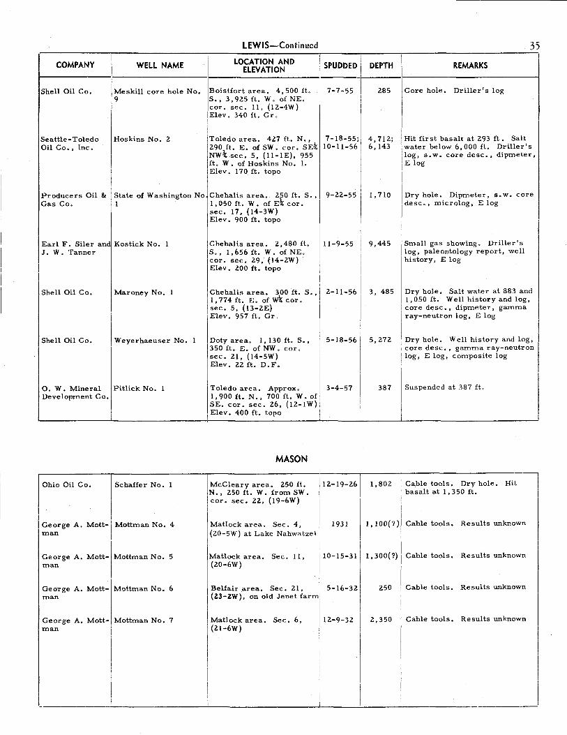
LEWIS-Continued
COMPANY I WELL NAME I LOCATION AND ELEVATION i SPUDDED I
t-S-h_e_l_l_0_1-. l-C-o-.--1 Me skill core hole No,
9 Boistfort area. 4,500 ft, S., 3,925 ft. W. of NE. cor. sec. 11, (12-4W) Elev. 340 ft. Gr.
7-7-55 ~1
Seattle-Toledo Oil Co., Inc.
Hoskins No. 2
'
Toledo area. 427 ft. N., 7-18-55; 290 ft. E. of SW. cor. SE\I 10-11-56 NW-t sec. 5, (11-lE), 955 ft. W. of Hoskins No. 1. Elev. 170 ft. topo
Producers Oil & Gas Co.
State of Washington No.Chehalis area •. 250 ft. S., l 1,050 ft. W. of Et cor.
sec. 17, (14-3W)
9-22-55
Earl F. Siler and Kostick No. l J. W. Tanner
Shell Oil Co. I Maroney No. l
Shell Oil Co. Weyerhaeuser No. l
0. W. Mineral Pitlick No. l Development Co.
i
Elev. 900 ft. topo
Chehalis area. 2,480 ft. S., 1,656 ft. W. of NE. cor, sec. 29, (14-2W) Elev. 200 ft. topo
11-9-55
Chehalis area. 300 ft. S., 2-11-56 1,774 ft. E. of W't cor. sec. 5, (13-2E) Elev. 957 ft. Gr.
Doty area. 1,130 ft. S., 5-18-56 350 ft. E. of NW. cor. sec. 21, (14-5W) Elev, 22 ft, D.F.
Toledo area, Approx. 1,900 ft. N., 700 ft. W. of SE. cor. sec. 26, (12-lW) Elev. 400 ft. topo
MASON
3-4-57
I
DEPTH
285
4,712; 6,143
1,710
9,445
I
I
35
REMARKS
Core hole, Driller's log
Hit first basalt at 293 ft. Salt water below 6,000 ft. Driller's log, s.w. core desc,, dipmeter, E log
I Dry hole. Dipmeter, s.w. desc., microlog, E log
core
Small gas showing. Driller's I 1og, paleontology report, well I history, E log
3, 485 Dry hole. Salt water at 883 and 11,050 ft, Wel_l history and log, I core desc., d1pmeter, gamma ray-neutron log, E log
5,272 Dry hole, Well history and log, core desc,, gamma ray-neutron log, E log, composite log
387 Suspended at 387 ft.
Ohio Oil Co. Schaffer No. 1 McCleary area, 250 ft. N., 250 ft. W. from SW. cor. sec, 22, (19-6W)
12-19-26 I 1,802 I
Cable tools. Dry hole, Hit basalt at 1, 350 ft.
George A, Mott- Mottman No. 4 man
George A, Mott- Mottman No. 5 man
George A. Mott- Mottman No. 6 man
George A. Mott- Mottman No. 7 man
Matlock area. Sec. 4, (20-5W) at Lake Nahwatzel I
Matlock area, Sec. 11,
1931
I I
10-15-31 I
I I Belfair area. Sec. 21, [ 5-16-321
(20-6W)
(23-ZW), on old Jenet farml
Matlock area. Sec. 6, 12.-9-32
I (21-6W)
Ill
I
I, I 00(?) Cable tools, Results unknown
l, 300( ?) Cable tools, Results unknown
250 Cable tools. Results unknown
2,350 Cable tools. Results unknown

36
COMPANY I WELL NAME
I Raymond Oil Co. lWillapa (Raymond) (?) or Willapa Harbor Oil Co.
I
Union Oil Co. of I McGowan No. California
I
Union Oil Co. of Smith No. California
Long Beach Oil Long Beach No, Co, (State No. 1)
W. H. Griffiths M, E. Halvorsen No. 1 & Associates
I Robert W. Over-\ Pacific Co. No. 1
, ton & Associates •I •Inc. I
I
Long Beach Oil I State No. 2 Co. !
Continental Oil Co.
Continental Oil Co.
Continental Oil Co.
Continental Oil Co.
Continental Oil
lco.
'
I Continental Oil 1co.
I IRA 1745
I
\
IRA 1741 !
I i I RA 1742
i I I RA 1743
I
I !RA 1744
j RA 1752
PACIFIC
I---Lo_c_A_T_1o_N_A_N_o ___ l1I-_sP_u_o_o_Eo_ll1-_o_E_PT_H_I/ _____ R_E_M_A_RK_s ___ -1 ELEVATION
f aymond area, NEt sec, 8-29-14 1,865 I Cable tools. Reported oil show-
30, ( 14-8W) (?) I ing at 1,005 ft, Gas at various depths, Driller's log
I )Megler area. Center S~ 2-19-29 4,385 j Cable tools to 2,880 ft., rotary
1sec. 22, (9-lOW) to bottom, Slight gas showing
iElev. 6 ft. Gr, reported. Driller's log, core I I desc. , well cuttings,
Grayland area, 1,600 ft, 14-19-48 S.; 2,250 ft. W. from NE. cor, sec. 31, (15-llW) I
I Elev. 10 ft. topo
I Long Beach area, In pro- 6-30-53 jected sec. 20, 75 ft. S.,
1
3,302 ft. W. of Nt cor. sec. 21, (10-llW)
l
)south Bend area. Approx. 9-23-53 700 ft. s., 2,900 ft. W. from NE. cor. sec. 27, (14-lOW) Elev. 100 ft. topo
I
!South Bend area. Approx. 1-21-54 2,900 ft. N., 600 ft. W.
l
from SE, cor. sec, 26, (14-lOW) Elev, 220 ft. topo
Long Beach area, l, 150 ft. S., 600 ft. W. from fE cor, sec, 8, (10-llW) Elev. 5 ft, Gr.
,Willapa area, 2,890 ft. Is., 3,960 ft. E. from NW. \cor. sec, 28, (14-7W) I Elev. 75 ft, Gr.
Willapa area, 200 ft, N., 350 ft, E. from SW. cor. sec. 21, (14-7W)
I Elev. 70 ft. topo
IW illapa area. 3,620 ft. N., 3,750 ft. W. from SW
1cor. sec, 21, (14-7W) IElev, 66 ft. Gr. l
\willapa area. 3,620 ft. N., 1,210 ft. E. from SW. cor. sec. 21, (14-7W) Elev, 150 ft. Gr.
4-14-54
6-25-54
5-30-54
6-7-54
6-10-54
4,927
2,103
868
530
670
1,408
1,212
1,085
1,486
I
Slight gas showings. Hit first volcanics at 1,053 ft, Well history and log, core desc., E log
Dry hole, Lith log, E log
Cable tools. Very small showing of oil reported
Results unknown
I Cable tools. Fresh water zone [ 50-55 ft. Trace of oil 340
I and 388 ft. Driller's log, lith log
I ! Core hole. Driller's log
I I
I I Core hole, Driller's log
I
I Core hole.
I
I I Core hole,
I I
Driller's log
Driller's log
l!illapaarea. 4,730ft. 6-14-54 1,115 ICorehole. J:·, 1,570 ft, W, from d; I
Driller's log
j~~:~.s:~o lt'. \~::7W) I
! I !westport area. 250 ft.N., 8-12-54 1,302 j Core hole. Driller's log I \850 ft; E. from SW. cor. ' \sec. 6, (14-7W) I I
I __ _ I Elev. 520 ft, topo I ·----------------------------~----------'-----------------

COMPANY WELL NAME
Continental Oil RA 1753 Co.
Continental Oil RA 1754 Co.
Continental Oil RA 1755 Co.
Continental Oil RA 1756 Co.
Continental Oil RA 1757 Co.
Continental Oil RA 1760 Co.
Continental Oil RA 1758 Co.
Continental Oil RA 1759 Co.
Continental Oil RA 1761 Co,
Continental Oil RA 1762 Co.
I I
Continental Oil I RA 1763 Co. I
I I
I !
United Develop- I Danny S. No. 1 ment Co., Inc.
I RA 1770
I
I
PACIFIC-Continued
LOCATION AND I SPUDDED I ELEVATION I
Willapaarea. l,320ft.N.,18-20-54 I 11,700ft. E. from SW. cor.1 sec. 26, (14-7W} :
I Elev. 120 ft. topo I
Willapa area. 210 ft. N., 8-23-54 280 ft. E. from w\ cor. sec. 8, (14-7W} Elev. 84 ft. Gr.
Willapa area. l,lOOft.S., 8-28-54 100 ft. E. from NW. cor. sec. 18, (14-7W} Elev. 62 ft. Gr.
Brooklyn area. 4,440 ft. 9-1-54 S., 4,150 ft. E. from SW. cor. sec. 18, (15-6W) Elev. 720 ft. (?) topo
\ Willapa area. 100 ft. N., 9-7-54 2,400 ft. W. from SE. cor sec. 13, (14-8W} Elev. 40 ft. topo
Willapa area. 1,600 ft. 9-20-54 N., 100 ft. E. from SW. cor. sec. 12, (14-8W) Elev. 60 ft. topo
Willapa area. 600 ft. s., 9-11-54 2,400 ft. E. from NW, cor. sec. 11, (14-8W) Elev. 80 ft. topo
W illapa area. 600 ft. s., 9-16-54 , 1,100 ft. W. from NE. cor. sec. 30, (14-7W) Elev. 53 ft. Gr.
Willapa area. 10 ft. N., 9-24-54 10 ft. E. from SW. cor. sec. 19, (14-7W) Elev. 64 ft. Gr.
Willapa area. 900 ft. N., 9-29-54 100 ft. E. from SW. cor. sec. 24, (14-8W) Elev. 35 ft. Gr,
Willapa area. 100 ft. s. ~ 10-1-54 1,600 ft. E. fr.om NW. cor. sec. 14, (14-8W) Elev. 30 ft. topo
i
Nemah area. Sec. 14, I I (12-lOW) ! Elev, 40 ft. topo
I
I I i Smith Creek area. 260 ft. II 11-5-54
1 S., 70 ft. W. from NE.
I' cor .• sec. 25, (15-8W)
1
,
Elev, 56 ft. Gr.
I I I I
I I
37
DEPTH I REMARKS
1,356 Core hole. Driller's log
1,236 Core hole. Driller's log
1, 177 Core hole. Driller's log
1,492 Core hole. Driller's log
1, 187 Core hole. Driller's log
1,400 Core hole. Driller's log
1, 113 Core hole. Driller's log
1,490 Core hole. Driller's log
1, 118 Core hole. Driller's log.
1, 158 Core hole. Driller's log
l, 198 Core hole, Driller's log
I Permit issued but well never spudded
!
1,582 Core hole. Driller's log
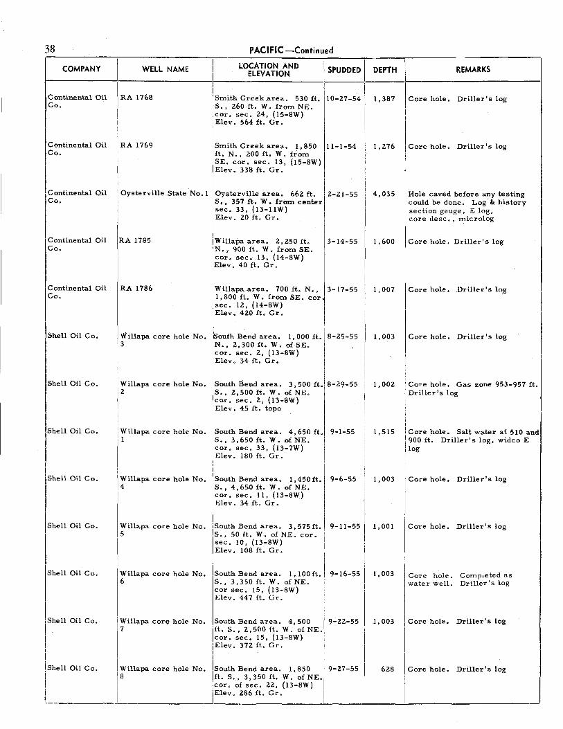
38 PACIFIC-Continued
COMPANY I
WELL NAME LOCATION AND I SPUDDED I DEPTH REMARKS ELEVATION
I 110-27-54 \ Continental Oil I RA 1768 Smith Creek .area, 530 ft, 1,387 Core hole, Driller's log
Co. S., 260 ft. W. from NE. cor. sec. 24, (15-SW) Elev. 564 ft. Gr,
Continental Oil RA 1769 Smith Creek area. I, 850 ll-1-54 I, 276 Core hole. Driller's log Co. ft. N., 200 ft, W. from
iSE. cor. sec, 13, (15-SW) I Elev. 338 ft. Gr.
I
Continental Oil Oysterville State No. 1 Oysterville area. 662 ft. Z-21-55 4,035 Hole caved before any testing Co. S., 357 ft. W. from center could be done. Log & history
sec. 33, (13-lIW) section gauge, E log, Elev. 20 ft. Gr. core desc. , microlog
Continental Oil RA 1785 Willapa area. 2, Z50 ft. 3-14-55 1,600 Core hole. Driller's log Co. N., 900 ft. W. from SE.
cor. sec. 13, (I4-8W) Elev. 40 ft. Gr.
Continental Oil RA 1786 IWillapa area. 700 ft.. N., 3-17-55 1,007 Core hole. Driller's log Co. 1,800 ft. W. from SE. cor.
1sec. 12, (14-SW) Elev. 420 ft. Gr.
Shell Oil Co. Willapa core hole No. outh Bend area. 1,000 ft. 8-25-55 1,003 Core hole. Driller's log 3 N., 2,300 ft. W. of SE.
cor. sec, 2, (13-SW) Elev. 34 ft. Gr.
Shell Oil Co. Willapa core hole No. South Bend area. 3,500ft. 8-29-55 1,002 Core hole, Gas zone 953-957 ft. 2 S., 2,500 ft. W. of NE. Driller's log
cor. sec. 2, (I3-8W) Elev. 45 ft, topo
Shell Oil Co. Willapa core hole No. South Bend area. 4,650 ft. 9-1-55 I, 515 Core hole. Salt water at 510 and 1 S., 3,650 ft. W. of NE. 900 ft. Driller's log, widco E
cor. sec, 33, (I3-7W) log Elev. 180 ft. Gr.
!shell Oil Co. I
I
I Core hole. Willapa core hole No. l South Bend area. l , 450 ft. 9-6-55 1,003 Driller's log 4
1
s .. 4, 6So n. w. o£ NE. cor, sec. 11, (I3-8W) Elev, 34 ft. Gr,
Shell Oil Co. Willapa core hole No, lsouth Bend area. 3,575ft. 9-11-55 1,001 Core hole. Driller's log 5
1
s., 50 ft, W, of NE. cor.
I sec, 10, (13-SW) Elev. 108 ft. Gr.
I I
Shell Oil Co. IWillapa core hole No, lsouth Bend area. 1,100ft. 9-16-55 I, 003 Core hole. Comp,eted as
16 S., 3,350 ft. W. of NE. water well. Driller's log I
cor sec. 15, (I3-8W)
I
Elev. 447 ft, Gr.
I I Shell Oil Co, I ~illapa core hole No. South Bend area. 4,500 9-22-55 1,003 I Core hole. Driller's log
\ft. S., 2,500 ft, W. of NE. I lcor, sec. 15, (13-SW)
I I I !Elev, 372 ft. Gr.
I I I I
I Willapa core hole No. I
I Core hole. 'Shell Oil Co. !South Bend area. 1,850 I 9-27-55 628 Driller's log
I rs 1ft. S., 3,350 ft. W. of NE./ I
' I lcor, of sec. 22, (13-SW) I
I I I ,Elev. 286 ft, Gr, I
! I I

COMPANY
Shell Oil Co.
Shell Oil Co.
Shell Oil Co.
Pacific Oil Wells Co. of Tacoma
Tacoma Pacific Oil Co. (?)
(?)
Mr. Swabodi
Mr. Swabodi
(?)
(?)
PACIFIC-Continued
I I LOCATION AND I SPUDDED I WELL NAME I
ELEVATION I I
Willapa core hole No. South Bend area. 4,125 ft.110-20-571 9 S., 875 ft. W. of NE. cor.
1
/
1sec. 5, (12-7W) i Elev. 231 ft. Gr. I I I I I
Willapa core hole No. !South Bend area. 4,850 110-22-55 J
10 1ft, S., 4,250 ft. W. of NE.
1 cor. sec. 15, (13-8W) I
I Camenzind No. 1
Elev. 230 ft. Gr. I I I ,
South Bend area. 3,650 112-19-55 I (Willapa core hole No. ft. S., 2,450 ft. W. of NE.
1
I 11) cor. sec. 25, (13-8W)
Elev. 100 ft. D.F. I I I
PIERCE
(?) lln Tacoma, near "C" Prior 1Street at Borough Road, to I sec. 30, (21-3E) 1902
(?) Orting area, Sec. 29 (?)' 1915 (19-5E)
Water well I Sumner area. Sec. 13, (?) (20-4E)
Swabodi water well No Longbranch area. Short 1947 l distance NW. of the st
cor. sec. 23, (20-lW)
I Swabodi wate, well No1 L=gbnneh a,ea. On same 1947 2 property, 100 ft. SW. frorr
Swabodi water well No. 1
(?)
I water well
i
SAN JUAN
East central part of Waldron Island
I I
Prior to
1927
1947
Wilbur H. son
John-1 Johnson water well
At edge of False Bay. I Probably sec. 33, (35-3W) I'
On Orcas Island, in Crowe I Valley between Orcas and I East Bay !
1947
DEPTH
1,421
814
2,935
(?)
2,600
620+
87
165
1,soo=
100±
147
39
REMARKS
Core hole. Completed as water well. Driller's log
Core hole. Driller's log
Original core hole deepened. Driller's log, widco E log
Cable tools. Details unknown
Cable tools. Good gas showing reported at l, 650 ft. Driller's log
Cable tools. Hit "mineralized" water and gas at 620 ft.
Cable tools. Good gas showing at 80 ft. Gas had H 2 S odor. Shut in pressure 7~ p. s. i. Bottom in drift
Cable tools. More gas than in first well but at same depth. Bottom in drift
Cores found at the well sites indicated penetration of congl. and sandstone.
I Freak occurj Small show of oil.
rence
Small show of oil. rence
Freak occur
I
. _ ___: ____ __c_ ____ __L._ _ __!___....!,_ ________ I

40
COMPANY
Pat Gibbons
Mr. Scott
I WELL NAME I
SKAGIT LOCATION AND
ELEVATION I I
IBay View, or Pat Gib- lMt. Vernon area. SE\ lbons, or G. N. Ry. 1sec. 31, (35-3E)
lscott water well lsamish Island. NE\ sec. i 136, (36-ZE), on Scott farm
I I . I Merger Oil & GaJMerger No. 1 lsamish Island. NE\ sec. Co I 36, (36-ZE), 200 ft. SE. of
I Scott water well
(?)
I (?)
H. S. Winters
w. c. Morris & I Co.
Columbia River Oil Co.
I
John E. Mc Manus
I
Is=• on Co. I
I
!
i
(?)
Bay View water wells
Winters water well
(?)
Kady-Olsen No. 1
(?)
Goodwin No, 1
I Sol Due Oil Co. / Sol Due Delfel No.
I I I I I I Machias Develop+ i ment Co. ' r
(?)
No,th side of Samish lslaml Probably sec, 26, (36-ZE)
N., R. 3 E. On Bay View Ridge. T.35 i
jHamilton area. swt sec. 30, (35-6E)
Alger area. NW\ sec, 32, (36-4E)
SKAMANIA
Skamania area. NE-tNW\ NE\ sec. 35, (2-6E)
SNOHOMISH
Near Stanwood station, or at Machias (?)
Arlington area. NW. cor. NW -t5E-tSW \ sec. 22, (31-4E)
Snohomish1aret,· Near
center NW'4NE4 sec. 15, (28-6E)
Snohomish area. Near center S. line SE-t sec, l 0, (28~6E)
I
I
I
DEPTH REMARKS SPUDDED I -----1----------------1
1912 I
Prior to I
1930 I
1-26-31
1930(?)
Prior to
1934
1934
8-18-37
5-17-49
1890(?)1
I 1925
1926
1927 .I
600
52
960
Cable tools. Bottom in Pleistocene sediments. Reports of gas and oil were erroneous,
Cable tools. Oil seeped into well during dry season of 1930
Cable tools, Reported oil showings doubtful. Bottom in schist
165 Cable tools. Bottom in :Reistocene sediments. No gas or oil
zoo± Cable tools. Gas showings in some of the 14 wells drilled. Bottom in Pleistocene sediments. Composite log from the 14 wells
30 Dug with a posthole auger. Unusual gas occurrence. Well log, gas analysis
932 Cable tools. Base of Pleistocene at 700 ft., graphitic schist below, Well cuttings
750 Cable tools. Oil showing report-ed at 250 ft. Reported to have penetrated Columbia River ba-salt near 590 ft. Hit artesian fresh water flow at 750 ft. Oil analysis from nearby seep
900 I Cable tools. First recorded oil ( 800?) I test in state. Abandoned becaus
I of mechanical difficulties
5,400 I Cable tools. Dry hole, Bottom
ll
j of hole in Oligocene sediments. Stratigrapt1ic column, paleontology report, driller's log
3,087 [ Cable tools. Gas and oil showI ings reported. Driller's log I
II
1,022 I
Cable tools. Base of Pleistocen, at 786 ft. Oil sand reported at l. 0 l2 ft. D,i[le, • s log I
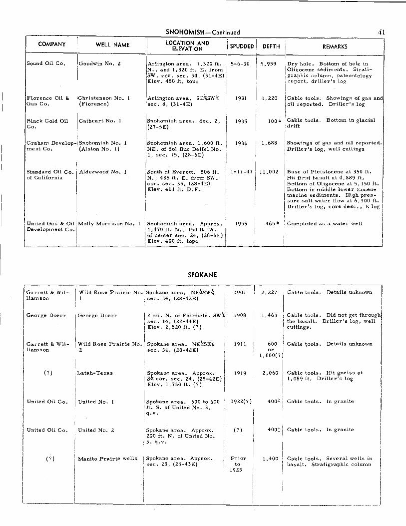
COMPANY
Sound Oil Co.
Florence Oil & Gas Co.
Black Gold Oil Co.
WELL NAME
Goodwin No. 2
lchristenson No.
I' (Florence)
Cathcart No. 1
Graham Develop- Snohomish No. ment Co. (Alston No. l)
Standard Oil Co. Alderwood No. 1 of California
I United Gas & Oil/ Molly Morrison No. Development Co.
SNOHOMISH-Continued
LOCATION AND ELEVATION I SPUDDED I
41
DEPTH REMARKS
------------1 1-----1----------------1
!Arlington area. 1,320 ft. 1 5-6-30 / 5,959 Dry hole. Bottom of hole in N., and 1,320 ft. E. from I I Oligocene sediments. Strati-1SW. cor. sec. 34, (31-4E) i I graphic column, paleontology Elev. 450 ft. topo I I report, driller's log
' I
I I Arlington area. SE-kswt I 1931 I sec. 8, (31-4E)
1
I Snohomish area. Sec. 2, jl 1935 I (27-5E)
'
II I Snohomish area. l, 600 ft. NE. of Sol Due Delfel No. l, sec. 15, (28-6E)
!South of Everett. 506 ft. N., 485 ft. E. from SW, cor. sec. 35, (28-4E) Elev. 461 ft, D.F.
1936
I I I I 11-11-47.
I I I I I I
Snohomish area. Approx. I 1955
1
1
1,470ft. N., 150ft. W. i of center sec. 24, (28-6E) 1
Elev. 400 ft. topo I
SPOKANE
l, 220
1,688
11,002
Cable tools. Showings of gas and oil reported. Driller's log
Cable tools. Bottom in glacial drift
Showings of gas and oil reported. Driller's log, well cuttings
Base of Pleistocene at 350 ft. Hit first basalt at 4,889 ft. Bottom of Oligocene at 5, 150 ft, Bottom in middle lower Eocene marine sediments. High pressure salt water flow at 6,300 ft. Driller's log, core desc., E log
Completed as a water well
Garrett & Williamson
Wild Rose Prairie No. "-;- ·'-- area. NE-kswt I
I
1901 2,227 Cable tools. Details unknown I !
George Doerr
Garrett & Williamson
(?)
I United Oil Co.
I United Oil Co.
George Doerr
Wild Rose Prairie No. 2
Latah-Texas
United No. l
United No. 2
sec. 34, (28-42E)
2 mi. N. of Fairfield. sec. 14, (22-44E) Elev. 2,520 ft.(?)
SW~
I
Spokane area. NEtSEt / sec. 34, (28-42E) i
I Sl'okane area. Approx. / S-t; cor. sec. 24, (25-42E) j
Elev. 1,750 ft.(?) ,
Spokane area. 500 to 600 ft. S. of United No. 3, q.v.
Spokane a.rea. Approx, 200 ft. N. of United No. 3, q.v.
1908
1911
1919
1922(?)
(?)
1,463
600 or
1,600(?
2,060
400±
400!:
Cable tools. Did not get through the basalt. Driller's log, well cuttings,
Cable tools. Details unknown
Cable tools. Hit gneiss at 1,089 ft. Driller's log
Cable tools. In granite
Cable tools. In granite
I I
I (?) Manito Prairie wells Spokane area. Approx. Prior 1,400 Cable tools. Several wells in II , sec. 28, (25-43E) to basalt. Stratigraphic column ' 1925
I I I I L ______ . ___________________ _l_ ___ _;_ ___ :.__ _______ ._~--·----.J

SPOKANE - Continued
WELL NAME DEPTH \ REMARKS
42
,--COMPANY LOCATION AND II SPUDDED I ELEVATION
i---------1-----------1-------------11-----1'-----1·--------------1 I I
Mead Oil & Gas Co., Inc.
Mead No. 1 (D.T.T.)
United Oil Co.; United No. 3 (Denny) Palouse Oil Co.
Spokane area. NW. cor. SE\ sec. 26. (27-43E)
Spokane area. NW. cor. sec. 33, (24-45E)
Wild Rose Gas & Wild Rose Prairie No. Spokane area. 600 ft. S., Oil Co. 3 600 ft. E. from NW. cor.
sec. 34, (28-42E)
(?)
Indian Foot Oil Co.
Puget Sound Petroleum Co.
Pacific States Oil Co.
Crescent Oil Co.
Oregon-Washington Oil Co. (?)
(?)
Chewelah No. 1
(?)
(?)
(?)
(?)
Hercules Sand- Scheel coal test stone Co.
STEVENS
On Mill Creek, NE. of Colville
Chewelah area. NE~NE\ sec. 10, (32-40E)
THURSTON
Between Tenino and Grand Mound
Centralia area. NE\ sec. 22, (15-3W)
Tenino area. Center s\ sd; sec. 32, (16-2W)
Tenino area. NE-kNW-k sec. 19, (16-lW)
Tenino area. NE\ sec. ZO, (16-lW)
, I I 1926(?) I I I
I I 1 1932; I 1
1937 I i I
I 1944 II
I
Prior to
1902
1930
1901
1914
1915
1915
1915(?)
Ohio Oil Co. Weyerhaeuser Timber Tenino area. 250 ft. S., 5-4-26 Co. No. 1 1,070 ft., W. of NE. cor.
SE:C, 10, (16-lW)
George A. Mott- Mottman Campbell No. Tenino area. Center SE-'t; 3-19-26 man 1 sec. 12, (16-2W)
George A. Mott- Mottman No. 2 Tenino area. NW\NE~ 1929 man sec. 18, (16-lW)
5, 280(?) Cable tools. 1n granite.
1,681; 2,250
3,600
1, 100
2,470+
Driller's log, well cuttings
Cable tools. Oil showings reported in granite. Well cuttings
Cable tools, Hit granite at 3,000 ft.
Cable tools. Drilled in limeston,
Cable tools. In Paleozoic meta-sediments. Driller's log, well cuttings
1, 000+ Cable tools. Results unknown
1,600(? Cable tools. Traces of oil and gas reported. Driller's log
2, 125(?) Cable tools. Traces of oil and gas reported. Driller's log
1,400
990
2,760
4,035
4,250
Cable tools. Traces of oil reported. Driller's log
Diamond drill. Oil showing reported at 900 ft. Driller's log
Cable tools. Chiefly basalt below 210 ft. Well history and log
Cable tools. Glacial drift to 180 ft. Top of Eocene volcanics at 2,365 ft, Small oil showing reported at 4,000 ft. Driller's log
Cable tools, Dry hole. Well cuttings
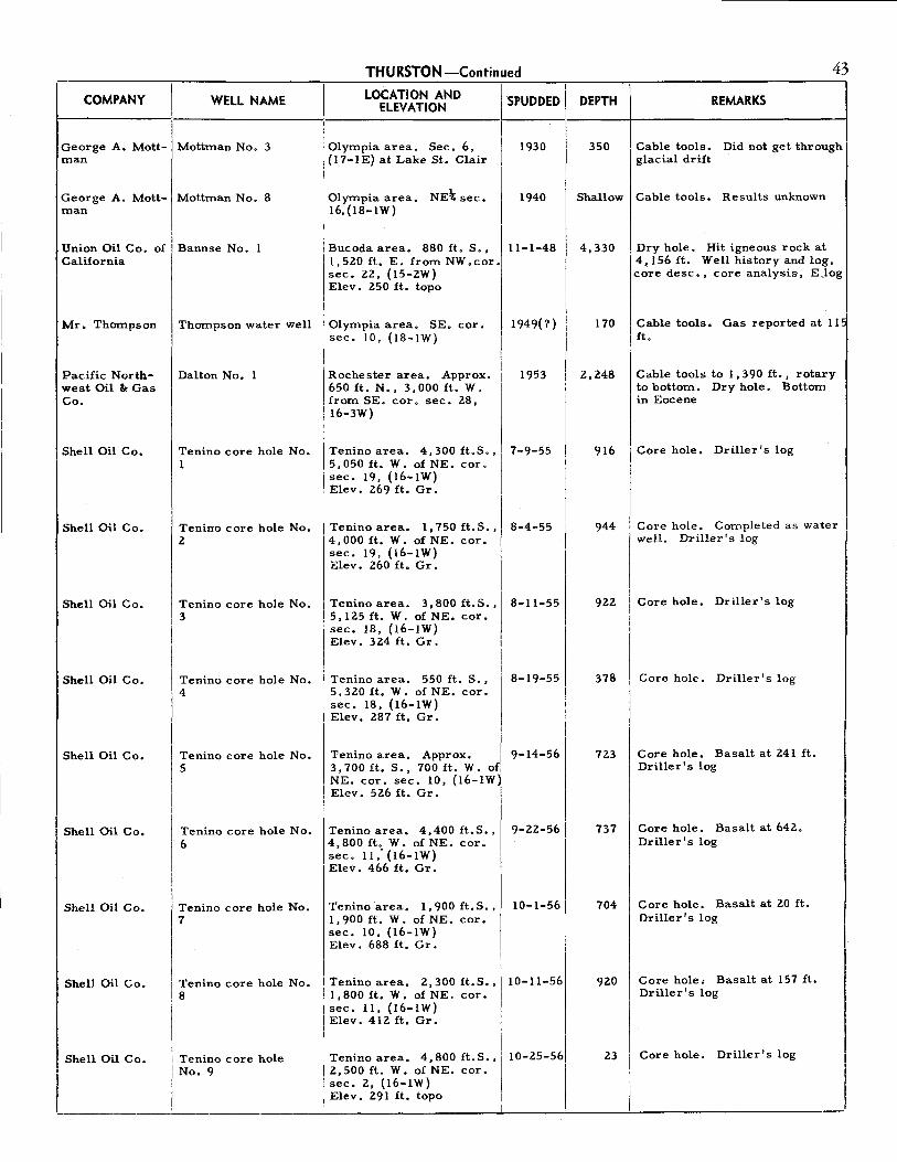
THURSTON-Continued 43
__ c_o_M_PA_N_v __ \i. ___ w_E_LL_N_A_M_E __ ·I---L_o_c_A_T_10_N_A_N_
0 __ \,_s_P_u_oo_E_o_
1
1_o_E_PT_H_I _____ R_E_M_A_R_K_s ___ ---l I ELEVATION -
I 1930 350
I
I
George A. Mott- Mottman No. 3 man
Olympia area. Sec. 6, (17-lE) at Lake St. Clair
George A. Mott- Mottrnan No. 8 man
Olympia area. NE\ sec. 16,(18-lW)
1940
Union Oil Co. of Bannse No. l California
I Bucoda area. 880 ft. S., I 1,520 ft. E. from NW.cor. sec. 22, (15-2W)
11-1-48
Mr. Thompson
Pacific Northwest Oil It Gas Co.
Shell Oil Co.
Shell Oil Co.
Shell Oil Co.
Shell Oil Co.
Shell Oil Co.
Shell Oil Co.
Shell Oil Co.
Shell Oil Co.
Elev. 250 ft. topo
Thompson water well Olympia area. SE. cor. 11949(?) sec. 10, {18-lW)
Dalton No. l Rochester area. Approx. 1953 650 ft. N., 3,000 ft. W. from SE. cor. sec. 28, I6-3W)
Tenino core hole No. Tenino area. 4,300 ft.S., 7-9-55 1 5,050 ft. W. of NE. cor.
sec. 19, (16-lW) Elev. 269 ft. Gr.
Tenino core hole No. Tenino area. l, 750 ft. S., 8-4-55 2 4,000 ft. W. of NE. cor.
sec. 19, (16-lW) Elev. 260 ft. Gr.
Tenino core hole No. Tenino area. 3,800 ft.S., 8-11-55 3 5,125 ft. W. of NE. cor.
sec. 18, (16-lW)
Tenino core hole No. 4
Tenino core hole No. 5
Tenino core hole No.
Elev. 324 ft. Gr.
1 Tenino area. 550 ft. S.,
15,320 ft. W. of NE. cor. i sec. 18, (16-lW) i Elev. 287 ft. Gr.
Tenino area. Approx. I 3,700 ft. S., 700 ft. W. of NE. cor. sec. 10, (16-lW~ Elev. 526 ft. Gr.
8-19-55
9-14-56
9-22-56
16 Tenino area. 4,400 ft.S., 4,800 ft. W. of NE. cor. sec. 11; (16-lW) Elev. 466 ft. Gr.
I i•nino mo hole No,
I I Tenino core hole No. ,s
I
Tenino area. 1,900 ft.S., 1,900 ft. W. of NE. cor. sec. 10, (16-lW) Elev. 688 ft. Gr.
Tenino area. 2,300 ft.S., J
1,800 ft. W. of NE. cor. I sec. 11, ( 16-1 W) I Elev. 412 ft. Gr.
10-1-56
10-11-56
I
I Shell Oil Co. I Tenino core hole
I No. 9
I Tenino area. 4,800 ft. S., I'
2,500 ft. W. of NE. cor. sec. 2, (16-IW)
10-25-561
I Elev. 291 ft. topo j I
Cable tools. Did not get through glacial drift
Shallow Cable tools. Results unknown
4,330
170
2,248
916
944
922
378
723
737
704
920
Dry hole. Hit igneous rock at 4,156 ft. Well history and log, core desc., core analysis, EJog
Cable tools, Gas reported at 11" ft.
Cable tools to l, 390 ft., rotary to bottom. Dry hole. Bottom in Eocene
Core hole. Driller's log
Core hole. Completed as water well. Driller's log
Core hole. Driller's log
Core hole. Driller's log
Core hole. Basalt at 241 ft. Driller's log
Core hole. Basalt at 642. Driller's log
Core hole. Basalt at 20 ft. Driller's log
Core hole, Basalt at 157 ft. Driller's log
Core hole. Driller's log
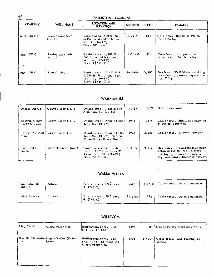
44
I
COMPANY I WELL NAME
I
I Shell Oil Co. I Tenino core hole
No. 10
I
Shell Oil Co. I Tenino core hole No. 11
. Shell Oil Co. I Bonnell No. 1
Oneida Oil Co. Grays River No. 1
Astoria-Grays Grays River No. 2 River Oil Co.
i George A. Mott! Grays River No. 3 man
I I I
Richfield Oil I Weyerhaeuser No. Corp.
I
I
Columbia Basin Attalia Oil Co.
Carl Kupers Kupers
I
Mr. Clark I Clark water well I
Pacific Oil WellJ Happy Valley (Fair-Co. I haven)
I
I I
1
THURSTON-Continued
I LOCATION AND ELEVATION
Tenino area. 500 ft. S., 13,450 ft. W. of NE. cor. sec. 2, (16-lW)
I Elev. 305 topo
Tenino area. 4,400 ft. S,, 200 ft. W. of NE. cor.
I sec. 34, (17-lW) 1 Elev. 297 ft. Gr.
Tenino area. 2., 122. ft.S., 1,058ft, W. of NE. coro sec. 10, (16-lW) Elev. 669 ft. D.F.
WAHKIAKUM
Oneida area. Possibly in NE\ sec. 31, (10-8W)
Oneida area. Nears\ cor sec. 28, (10-8W)
Oneida area. Near s\cor sec. 2.8, (10-8W), 300 ft. W, of Grays River No. 2
Grays Bay area. 1,569 ft. S., l, 739 ft. E. of W. \ cor. sec. 31, (10-8W) Elev. 50 ft. Gr.
WALLA WALLA
Attalia area, 4, (7-31E)
swt sec. I
I Attalia area. I 4, {7-31E) j
swt sec.
WHATCOM
!Bellingham area. SE-1; 1sec. 7, (37-3E)
I Bellingham area. SE\ sec. 7, (37-3E) near the Clark water well
I SPUDDED I
I 10-27-561
I I
I
I I 10-2.8-56
I 1-13-57 I
1907(?)
192.6
1927
8-2.0-55
192.0
6-12-52
I
1893
1901
DEPTH REMARKS
640 , Core hole. Basalt at 390 ft. I Driller's .log
918 Core hole. Completed as
I
water well. Dr ill er I s log
5,980 Dry hole. Well history and log, ,
I
core desc,, gamma ray-neutron log, E log
250± Details unknown
1,275 Cable tools. Small gas showing at 700 ft. reported
I 2,180 Cable tools. Results unknown
9, 110 Dry hole. In volcanic flow rock, below 8,450 ft. Well history and log, gamma ray-neutron log, microlog, dipmeter survey
I 3, 200± I Cable tools. Details unknown
,,. I Cable tools, Details unknown
I
30 I Gas showing, discovery well.
!
1,000+ Cable tools. Gas showing re-ported
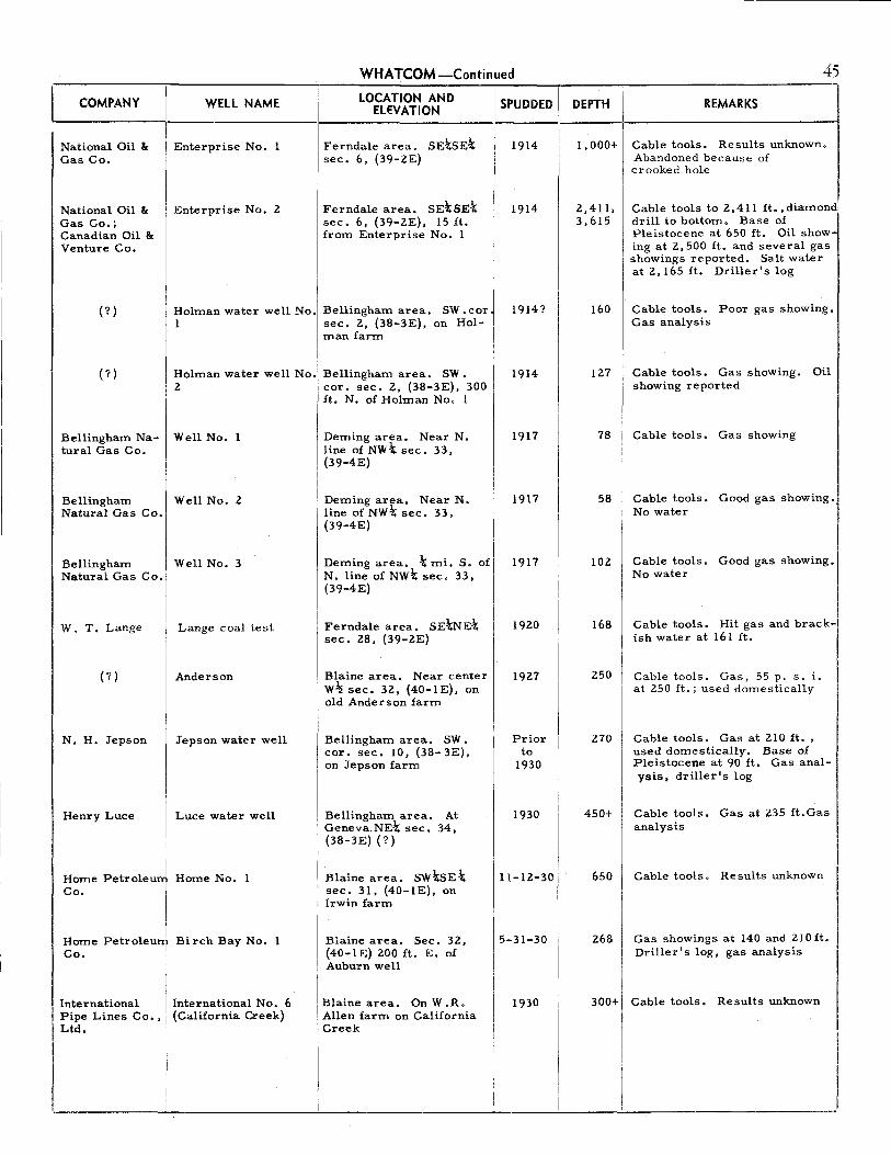
WHATCOM-Continued
COMPANY WELL NAME 1
1
LOCATION AND I' SPUDDED I '-------:--------- ELEVATION I
National Oil & Gas Co.
Enterprise No. 1 I Ferndale area. SEtsEt
1
1 1914 I sec. 6, (39-2E)
I National Oil & Gas Co.; Canadian Oil & Venture Co.
Enterprise No. 2
I
Ferndale area. SE.\SEt sec. 6, (39-2E), 15 ft. from Enterprise No. 1
(?) Holman water well No. Bellingham area. SW .cor 1 sec. 2, (38-3E), on Hol
man farm
(?) Holman water well No. Bellingham area. SW. 2 cor. sec. 2, (38-3E), 300
ft. N. of Holman No. 1
Bellingham Na- Well No. 1 tural Gas Co.
Bellingham Well No. 2 Natural Gas Co.
Bellingham Well No. 3 Natural Gas Co.
W. T. Lange
(?)
N. H. Jepson
Henry Luce
Home Petroleu Co.
I Home Petroleul Co.
I
Lange coal test
Anderson
Jepson water well
Luce water well
Home No. 1
Birch Bay No. 1
International I International No. 6 Pipe Lines Co., I (California Creek) Ltd. I
I
i
Deming area. Near N. line of NWt sec. 33, (39-4E)
I . I Demmg area. Near N. line of NWt sec. 33, (39-4E)
Deming area. t mi. S. of N. line of NWt sec. 33, (39-4E)
Ferndale area. SE.\NEt sec. 28, (39-2E)
Blaine area. Near center W~ sec. 32, (40-lE), on old Anderson farm
Bellingham area. SW. cor. sec. 10, (38-3E), on Jepson farm
Bellingham area. At Geneva.NEt sec. 34, (38-3E) (?)
I
Blaine area. SWt5Et sec. 31, (40-lE), on Irwin farm
I Blaine area. Sec. 32, (40-lE) 200 ft. E. of
I Auburn well i
I Blaine area. On W.R.
I Allen farm on California Creek
I
1914
1914? i
1914
1917
1917
1917
1920
1927
Prior to
1930
1930
I I
I 11-12-301
! I 15-31-30 I
I ,,,, I
i
I
I
45
REMARKS DEPTH I 1---------------1
1,000+
2,411, 3,615
160
127
78
58
Cable tools. Results unknown. Abandoned because of crooked hole
Cable tools to 2,411 ft. , diamond: drill to bottom. Base of Pleistocene at 650 ft. Oil showing at 2,500 ft. and several gas showings reported. Salt water at 2,165 ft. Driller's log
Cable tools. Poor gas showing. Gas analysis
Cable tools. Gas showing. Oil showing reported
Cable tools, Gas showing
Cable tools. Good gas showing., No water
102 I Cable tools. Good gas showing. No water
168
250
Cable tools. Hit gas and brackish water at 161 ft,
Cable tools. Gas, 55 p. s. i. at 250 ft.; used domestically
270 Cable tools. Gas at 210 ft. , used domestically. Base of Pleistocene at 90 ft, Gas analysis, driller's log
450+ Cable tools. Gas at 235 ft.Gas analysis
650 Cable tools. Results unknown
268 Gas showings at 140 and 210 ft, Driller's log, gas analysis
300+ I Cable tools, Results unknown
i

46 WHATCOM-Continued
ELEVATION DEPTH REMARKS COMPANY I WELL NAME
International Pip I lnte,nati=al No. 4 Lines Co., Ltd.1 (Goshen)
LOCATION AND II SPUDDED
-----1-----1----------------1
~ooksack area. NE\SE\ 1930 sec. 14, (39-3E) on Graetzer farm
Acme Oil & Gas I Acme No. I Ferndale area. s.JiisEt 1930 Co. 'sec. 13, (39-lE)
Acme Oil & Gas Co.
Acme No. 2,also call- Ferndale area. s.JiisE\ sec. ed Acme No. I 13, (39-lE), 20 ft. from
Acme No. I
Kulshan Natural Lange No. 1 Gas & Oil Co.; M.& M. Gas & Oil Co.
International Pipe Lines Co,, Ltd.
I International Pipe Lines Co., Ltd.
Iv,.s Gas & Oil Corp.
I International Pipe Lines Co. ,
I Ltd.
Ives Gas & Oil Corp.; Curtis Natural Gas Co.
International No. 5 (Laurel)
International No. 3
I (Jepson No. I)
I Ives No. 1
I I Ridge No. l
I I Ives No. 2
I I
M.& M.Oil & Gasj Lange No. 2 Co, I
I Geo. Cowden et.I Ridge No. 2
I al. I
I I Olsen-Orloff [', Molin No. 1
! Syndicate
I i Grate-McDonaldi Ross No. 1
' I,
I. !
Grate-McDonald' Jensen No. 1
I I I
!
I ___ _
Ferndale area. SE\NE\ sec. 28, (39...;2E), about 50 ft. from Lange coal test
Near Laurel. May be in sec. 19, (39-3E)
BeUingham area. Pro- I bably near SW. cor. sec, IO, (38-3E), on Jepson farm
Nooksack area. ~ NW\ sec. 21, (40-4E), on H.O. Brown farm
Bellingham area. Center sec. 15, (38-3E), on Alabama Ridge
Nooksack area. Sec. 21, (40-4E) on H. O. Brown farm
Ferndale area. SE\NE\ Ii
sec. 28, (39-2E), 14 ft. I E. of Lange coal test
Bellingham area. Proba- I
bly near center sec. 15, I
(38-3E) . I
. I I Bellingham area. Sec. 7, I
1
(38-4E) , on Molin farm I I I I Bellingham area. Sec. 17' [ (38-4E), on Ross farm
I Bellingham area. NE\NE~ [sec. 19, (38-4E), onH. W 1 I Jensen farm '
i
1930
1930
1930
1930
1931
1931
1931
1931
1931
1931
1931
1931
I
I I I i
I I
I i I
1, 206 Cable tools. Results unknown
310 Cable tools. Gas showing reported
1,241
1, 180
970
I
Cable tools. Gas and oil showings reported. Driller's log
Cable tools. Gas showings from various depths
Cable tools. A continuation of 383 ft. water well. Gas. showing reported at 630 ft. Driller I s log
I, 000(? )I Cable tools. Results unknown
I 275 I Cable tools. Results =kn-
1, 625 I Cable tools. Gas showing at I 685 ft. Three feet of glacial I drift. Driller's log
l, 000; 1
1
1 Cable tools. Gas showing at l, 350 990 ft. Driller's log from
1,024 ft. to bottom
I 2,008 I I
Rotary to 450 ft. Cable tools below. Base of Pleistocene at 154±. Several gas showings; used domestically. Driller's log, gas analysis, well cuttings
I
I
420 Cable tools. Results unknown
I 11 O+ I Cable tools. Results unknown
100± I Cable tools. Results =kn=•
200 I Cable tools. Hit nitrogen gas
I at 125 ft.

WHATCOM-Continued 47
COMPANY WELL NAME LOCATION AND I SPUDDED I DEPTH REMARKS i-------i---------·I----E_LE_V_A_T_IO_N ____
1i. --~:I----i------------1
Greenacres Memorial Park
1
1 I Greenacres water well Ferndale area. Near SW. 1932
Whatcom Natura Whatcom No. 1 Gas Corp. (Lange No. 3)
Whatcom Natural Gas Corp.
Whatcom Natural Gas Corp.
Whatcom Natural Gas Corp.
Van-Bell Holding Co,
Whatcom Natural Gas Corp.
Whatcom Natural Gas Corp.
Lingbloom No. (Chamber of Commerce No. 1,)
Lingbloom No. 2 (Chamber of Commerce No. 2)
Lingbloom No. 3 (Chamber of Commerce No. 3)
Bettsinger No. 2
Whatcom No. 2 I (Lange No. 4)
Lingbloom No. 4 (Chamber of Commerce No. 4)
cor. SE\ sec, 22,(39-2E)
Ferndale area. Et cor. · sec. 28, (39-2E), on Lange farm
II
1933
Ferndale area. NW:l,;sw:!,; 11-12-33 NW\ sec. 27, (39-2E), on J.E. Lingbloom farm
Ferndale area. swl,;swt 1933 NW\ sec. 27, (39-2E), on O.H. Lingbloom farm
Ferndale area. NE:l,;swl,; 1933 NW\ sec. 27, (39-2E), on J.E. Lingbloom farm
Ferndale area, SEtNE\ sw\ sec. 27, (39-ZE), on E, Bettsinger farm
Ferndale area. 650 ft. W .\ of E\ cor. sec. 28, (39-2~,I on Lange farm
Ferndale area. SE:l,;sw:!,; NWt sec. 27, (39-2E), on 0. H. Lingbloom farm I
1933
1934
1934
Whatcom Natural Gas Corp.
Chamber of Commerce Ferndale area. SW, cor. 1934 No. 5 sec. 27, (39-2E), onF.E.
Abbotsford Oil Beyers No. 1 & Gas Co.
Van-Bell Gas & Cowden No. 1 Oil Co.
Van-Bell Gas & Oil Co.
Van-Bell Holding Co.
A. W. Hunter
Cowden No. 2
Bettsinger No. I (Van-Bell No. 1)
Harden No. 1 (Hunter No. 1)
Brown farm
, Ferndale area. Near the SE. cor. NEtNW\SWt sec. 27, (39-2E)
Ferndale area. Near center SEtNEt sec. 28, (39-2E), 75 ft. E. of Livermore No. 1
Ferndale area, Near Et cor. sec. 28, (39-2E), 200 ft. N. of Whatcom No. l
Ferndale area. SE\NEt sw,k sec. 27, (39-2E), on I E. Bettsinger farm I
i
I Ferndale area. SW. cor. I NE:l,;sw!;; sec. 27, (39-2E), I on L. W • Harden farm ,
I
1934
1934
1934
1934
1934
775
175
171
172
212
(?)
216
166
701
238
390
205
603
193
Cable tools. Gas showing at 530 ft. Driller's log
Cable tools. Good gas showing at 175 ft.; used domestically. Driller's log, well cuttings, gas analysis
Cable tools. Good gas showing at 171 ft.; used domestically, Driller's log, gas analysis
Cable tools. Good gas showing at 172 ft.; used domestically. Gas analysis
Cable tools. Dry hole
Cable tools. Results unknown
Cable tools. Dry hole
Cable tools. Good gas showing at 166 ft.; used domestically. Gas analysis
Cable tools. Poor gas showing with salt water at 696 ft. Driller's log, well cuttings
Cable tools, Dry hole. Driller'! log
Cable tools. No gas; reported oil doubtful
Cable tools. Dry hole
Cable tools. Poor gas showing; reported oil showing doubtful. Salt water at 500 ft. Driller's log, well cuttings l Cable tools. Good gas showing,! 193 ft.; used domestically. i Driller's log I
J

48 WHATCOM-Continued
COMPANY DEPTH REMARKS I WELL NAME LOCATION AND II SPUDDED II
II ELEVATION
1-------------------1-------------i-----'-----·!----------------1 A. W. Hunter
A. W. Hunter
Abbotsford Oil & Gas Co.; W. Hale
Shale Oil & Gas Co.
Van-Bell Holding Co.
Covey-Baus
(?)
(?)
(?)
(?)
Mr, Green
Mr. Erickson
Mr. Barnhart
(?)
1
1
Harden No. 2 Ferndale area, NW-tSE-k I 1934 (Hunter No. 2) i swt sec. 27, (39-2E), 650,
I I ft. S. of Harden No. 1 I
I Hunter No. 3 Ferndale area. Near SE. 1934
cor. NE-tSW-t sec. 27, I (39-2E)
King No. 1 (Hale No. 1)
Shale Oil & Gas No.
Holman No. 3
Hanson No. 1 (Covey-Baus No. 1)
water well
Selien No. 1
water well
diamond drill hole
Green water well
Erickson water well
Barnhart water well
water well
Ferndale area. SE%8E-t SW\ sec, 27, (39-2E), on C.C. King farm
I
1 I Bellingham area, SE-tNWJ NW\ sec. 3, (38-2E), on
1 Harry Brown farm I
Bellingham area, SW.cor. sec. 2, (38-3E), 30 ft. E, of Holman No. 1
Ferndale area. NW-tNE-t sec. 35, (39-2E), on Han-1 son farm
Bellingham area. SW-tSWJ sec. 2, (38-3E) ·1
Blaine area. Center E\ II
~~~~~~~·~::~.E)~:=. I sec. 6, (38-4E)
Bellingham area. sec. 6, (38-4E)
SE-t
Deming area. NW-t sec. 33, (39:-4E), on Green farm
Deming area. Near N. line of NW\ sec. 33, (39-4E) (?)
! Deming area. SW-t sec. I
32, (39-4E) (?) about l mi, SW. of Erickson farm I
Deming area. Near S. line of sw\ sec. 28, (39-4E)
i
1934
1934
1934
1934
Prior to
1935
Prior to
1935
Prior to
1935
Prior to
1935
Prior to
1935
Prior to
1935
Prior to
1935
Prior to
1935
415:!:
330
1,370
251
151
300:!:
28
335
156
962
68+
61
80+
(?)
Cable tools. Gas showing at 200 ft. Well cuttings
Cable tools. Good gas showing at 330 ft. reported
Cable tools. Bottom of Pleistocene at 342 ft. Gas showing with salt water at 780-800 ft.; 970-1,010 ft.; 1160-1,370 ft. Pressure 470 p.s.i. Driller's log, gas analysis, well cuttings
Cable tools. Dry hole. Driller': log
Cable tools. Dry hole. Driller's log
Cable tools. Dry hole. Well cuttings
Gas showing at 28 ft.
Cable tools. Dry hole. Top of Chuckanut 155 ft. Driller's log
Cable tools. Poor gas showing with water, 156 ft.
Gas showing, 495 ft. Driller's log
Cable tools. Gas showing, 68 ft. Gas analysis
Cable tools. Gas, 61 ft; used domestically. Gas analysis
Cable tools. Gas showing, 80 ft. Deepened for water
Cable tools. Gas with fresh water
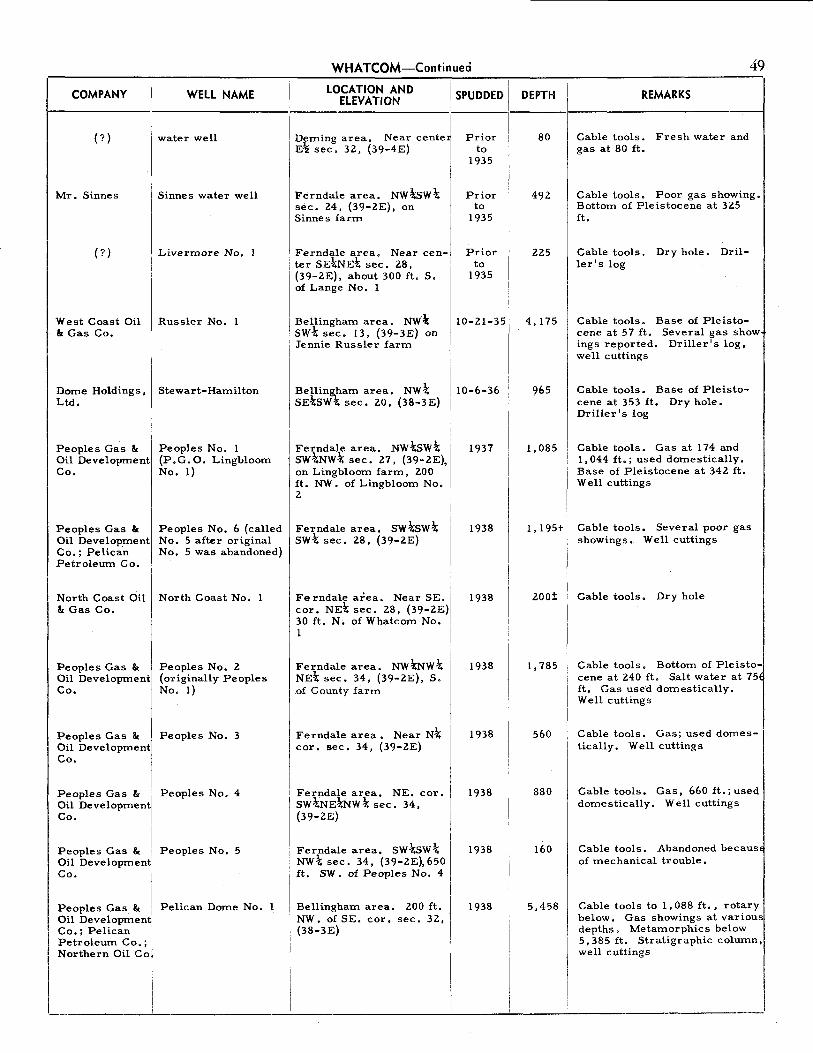
COMPANY WELL NAME
(?} water well
Mr. Sinnes Sinnes water well
(?} Livermore No. 1
West Coast Oil Russler No. 1 &: Gas Co.
Dome Holdings, Stewart-Hamilton Ltd.
Peoples Gas & Peoples No. 1 Oil Development (P.G.O. Lingbloom Co. No. 1)
Peoples Gas & Oil Development Co,; Pelican Petroleum Co.
North Coast Oil & Gas Co,
Peoples No. 6 (called No, 5 after original No. 5 was abandoned)
North Coast No. l
Peoples Gas & Peoples No. 2 Oil Development (originally Peoples Co. No. 1)
Peoples Gas & Oil Development Co.
Peoples Gas & I Oil Development! Co.
I Peoples Gas & I Oil Development Co.
I Peoples Gas & I Oil Development1· Co,; Pelican
I Petroleum Co.; I Northern Oil Co/
L I
Peoples No. 3
Peoples No. 4
Peoples No, 5
Pelican Dome No. 1
WHATCOM-Continued
ELEVATION DEPTH LOCATION AND 1· SPUDDED II
!-----1 I
. Dfming area. Near cente~ Prior 1·
E'!i sec, 3Z, (39-4E} I to 1
Ferndale area. NWbw\ · sec. 24, (39-ZE}, on Sinnes farm
Ferndale area. Near center SEtNE\ sec. Z8,
I 1935 I I ! I I
I pp/t9roo:1005rrl'
(39-ZE}, about 300 ft. S. 1935 of Lange No. 1
Bellingham area. NW\ SW\ sec. 13, (39-3E} on Jennie Russler farm
Belling,ham al"ea. NW\ sd;SW-i; sec, 20, (38-3E)
Ferndale area. NWbw\ SW\NWJ,; sec. Z7, (39-ZE}, on Ling bloom farm, ZOO ft. NW. of Lingbloom No. 2
Ferndale area, swbw.J,; sw.J,; sec, Z8, (39-ZE}
Ferndale area. Near SE, cor, NEt sec. 28, (39-ZE} 30 ft, N. of Whatcom No. r
1
Ferndale area. NWtNW\ NEt sec. 34, (39-ZE}, S. of County farm
Ferndale area • Near Nt cor, sec. 34, (39-ZE)
Ferndale area, NE. cor, SWtNEtNW\ sec. 34, (39-ZE}
Ferndale area. sw.J,;sw.J,; NWt sec. 34,. (39-ZE),650 ft. SW, of Peoples No. 4
Bellingham area. ZOO ft. NW. of SE. cor. sec. 3Z, (38-3E}
10-21-35
10-6-36
1937
1938
1938
1938
1938
1938
1938
1938
80
49Z
225
4,175
965
1,085
1,195+
zoo±
1, 785
560
880
160
5,458
REMARKS
Cable tools. Fresh water and gas at 80 ft,
49
Cable tools. Poor gas showing. Bottom of Pleistocene at 3Z5 ft.
Cable tools. Dry hole. Driller's log
Cable tools. Base of Pleistocene at 57 ft. Several gas show ings reported. Driller's log, well cuttings
Cable tools. Base of Pleistocene at 353 ft, Dry hole. Driller's log
Cable tools. Gas at 174 and l, 044 ft.; used domestically. Base of Pleistocene at 34Z ft. Well cuttings
Cable tools. Several poor gas showings. Well cuttings
Cable tools. Dry hole
Cable tools. Bottom of Pleistocene at Z40 ft, Salt water at 75 ft. Gas used domestically. Well cuttings
Cable tools. Gas; used domes-1 tically, Well cuttings
Cable tools. Gas, 660 ft.; used I domestically. Well cuttings
Cable tools, Abandoned becaus of mechanical trouble.
Cable tools to 1,088 ft,, rotary below. Gas showings at various depths. Metamorphics b~low 5,385 ft. Stratigraphic column,! well cuttings
___ I

50 WHATCOM-Continued
l,___c_o_M_PA_N_Y __ ll ___ w_E_LL_N_A_M_E __ .i_ __ L_o_c_A_T_lo_N_A_N_o ___ l_s_Pu_o_o_E_D l __ o_E_PT_H_ll!----~R_E_M_A_R_K_s ____ , I ELEVATION
I I
Standard Oil Co. Ferndale community of California
Pleasant Valley Hillje No. 1 Gas and Oil Co.
Ferndale area. 330 ft. S. 11-12-451 and 1,650 ft. W. of NE. I car. sec. 5, (39-lE)
Blaine area. SW. car. 1947 SEtNWt sec, 32, (40-lE)
6, 231 Dry hole. We 11 history and log, core desc. , well cuttings and c.ores, E log
432 Cable tools. Small gas showings at 132, 170, and 400 ft. Bottom of Pleistocene at 165 ft. Gas analysis
Meridian Oil Corp.
Hillebrecht No. 1 Ferndale area. NW\sEt sec. 6, (39-3E)
1947 3,492 Gas showings at 790 and 1, 200 ft. Well history, driller's log, core desc., well cuttings, E log, core analysis
Pleasant Valley Gas and Oil Co.
Pleasant Valley Gas and Oil Co.
Dahle No, 1
Mills No. 1
I Puget Sound Soderberg No. 1 Development Co.
Pleasant Valley Hart No. 1 Gas and Oil Co. I
Pleasant Valley Dahle No. 2 Gas and Oil Co.
I Pleasant Valley I Hillje No. 2 Gas and Oil Co, J
Pleasant Valley Seline No. 1 Gas and Oil Co.
Pleasant Valley Gas and Oil Co.
Pleasant Valley Gas and Oil Co.
I Lynden Gas & I Oil Developmenl Co. and Pacific
Gas & Oil I Development Co.
Heinrich No. 1
Johnson No. 1
Thom No. 1
Elev. 65 ft. topo
Blaine area. Center sw\ NWt sec. 32, (40-lE)
Blaine area. SE. cor. SEtNEt sec. 31, (40-lE)
Ferndale area. E\sw.Ji. NEt sec. 11, (39-lE)
I Blaine area. 330 ft. S., 330 ft. E. from wt cor. sec. 33, (40-lE)
About 100 ft. NE. of Dahle No·. 1
1950
1951
12-13-51
1952
1952
About 400 ft. NE. of 1952 Hillje No. 1
Blaine area. 640 ft. N., 1952 480 ft. W. from Et cor. sec. 32, (40-lE)
Blaine area, SE. cor. I NWtNW\ sec. 32, (40-lE)
Blaine area. NW-lsWtNEJ
1
sec. 32, (40-lE) I
Lynden area. NEtNW\ sec. 14, (40-4E)
1952
1952
1-5-53
380
300
Cable tools (?). Good gas show ing from three zones. Bottom of Pleistocene at 217 ft. Driller's log
Cable tools. Dry hole
1, 902± Cable tools. Suspended. Oil reported. Salt water from near bottom. Oil analysis
400± Results unknown
204 Cable tools. Good gas showing
356 Cable tools. Good gas showing; used domestically
350+ I Cable tools. reported
Poor gas showing
4001: Cable tools. Dry hole
400± Cable tools. Poor gas showing
1, 173 Cable tools. Some gas reported
I Evergreen Gas I Ridgeway-Heppner Lynden area. 50 ft. N., 1953 200- Abandoned because of mechan-
No. 1 400 ft. W. from SE. cor. 1
NE\sE\ sec. 1, (41-3E)
1953
Ii and Oil Co. \ No. 1-A I ft. E. of Ridgeway-
; j ,
11
1 ~~JJ~~~f~t·. ~~po I
I I I ! L ____ I I I ·----'--·----------'-------------'-----L------'--------------'

COMPANY I 1--------1
Kris Petroleum i Ltd. I
Kris Petroleum I (Wash.)Inc. I
I
I
WELL NAME . Ridgeway-Heppner No. 2
Kris Whatcom No. 1
WHATCOM-Continued
LOCATION AND ELEVATION ! SPUDDED I
I Lynden area. 55 ft. W. of! 1953
:~:~:::~·:::·~.N:c.-o' r. :
1
1
4 - 4 - 55
I
, 630 ft. W. from NE. sec. 1, (40-2E) Elev. 125 ft. topo
1
YAKIMA
I
DEITH I 2,853
5,710
City of Mabton Mabton water well No. Within the city of Mabton. Prior j l, 140 to l Elev. 718 ft. topo
Simcoe Oil Co. Simcoe No. 1
Miocene Petro- Union Gap leum Co.
Denny Oil Go. Denny No. l
Kamiakin Oil & Laura Lee No. l Gas Go.
Campbell Petroleum Go,
City of Mabton
Northwestern Natural Gas
Mr. Denny
Paul John Hunt
E. Dewey Bailey
Campbell No. 1
Mabton water well No. 2
Sun Valley No. l
(?)
Snipes No. l
Bailey No. l
Wapato area, ~NW.!,; sec. 24, (ll-17E)
Yakima area. NEtNWt sec. 177-(12-19E)
Wapato area. 7 mi. W. of town
Grandview area. Sec. 21, (9-23E)
1922
1924(?)
1929
1930
1930
Mabton area, 400 ft. NE. 9-21-30 of Mabton water well
!
Within the city of Mabton. I 100 ft./No. of Mabton water well No. 1
Mabton area. S~NW.l,;sd; sec. 36, (9-22E)
Near Selah
Sunnyside area. Near center sec, 33, (10-22E)
Naches area. NEtNW.!,; NE\ sec. 24, (14-17E) Elev. 1,610 ft. topo
1935
1937
1939
1944
1946
2,760
3,810
615
1,230
583
1,188
1,250
(?)
1,408
446
I :~,e,~wey Bailey No. 2 Naches area. 120 ft. E. of Bailey No. 1. Elev. 1,600 ft. topo
1947 525
I
REMARKS
Results unknown
Suspended. Lith log from 960 ft, to bottom
51
Gable tools, Good gas showing with water. Stratigraphic column, gas analysis, driller's log
Gable tools, Reported oil show ing questionable. Flowed warm water. Well cuttings
Cable tools, Gas and tar-like oil showings, Driller's log, well cuttings
Cable tools. Reported oil and gas showings questionable
Cable tools. Gas showing reported
Gable tools. Results unknown. Driller's log
Cable tools. Good gas showing with water. Driller's log, stratigraphic column,· well cuttings
Gable tools. Gas and tar-like oil reported. Driller's log, well cuttings
Results unknown
Cable tools, Gas showing. Driller's log, gas analysis, well cuttings
Water well deepened from 270 ft. Low-pressure gas at 445 ft. Driller's log, well cuttings, gas analysis
Low-pressure gas at 423 ft. Driller's log, well cuttings, gas analysis
I_ __ . --·--------------'-------------~------'------'----------------

52 YAKIMA-Continued
COMPANY I
WELL NAME LOCATION AND I SPUDDED I I
ELEVATION DEPTH I
REMARKS
I I (?) Strong gas flow at 866 ft. Leo E, Harrigan water well Horse Heaven Hills
I 1947
10 mi. ESE. of Mabton I
Leo Oil Co. Phillips & Haggerty Yakima Ridge. Approx. 13-11-55 1,023 Diamond drill hole. In basalt No. 1 100 ft., S., 1,000 ft. E. of from top to bottom
NW. cor. sec. 23, (13-23E) Elev. 2,140 ft. topo I
'
I
I I I
I
I
I
I I I
I I I
I
I
I I
I I
I I I
I I I
I I I I
I

53
BIBLIOGRAPHY
Arnold, Ralph, 1906, Geological reconnaissance of the coast of the Olympic Peninsula, Washington:. Geol. Soc. America Bull., vol. 17, p. 451-468.
, 1909, Environment of the Tertiary faunas of the Pacific --c=-o-a_s_t,---o-,f,.....t.,..,h-e---.U.....-nited States: Jour, Geology, vol. 17, p. 509-533.
, and Hannibal, H, , 1913, The marine Tertiary stratigraphy ----;:--,.,..----,,..,,...--=--
of the north Pacific coast of America: Proc. Am. Phil. Soc., vol. 52, p. 559-605.
Beck, R. S., 1943, Eo·cene Foraminifera from Cowlitz River, Lewis County, Washington: Jour, Paleontology, vol. 17, no. 6, p. 584-614.
Bennett, W. A. G., 1939, Bibliography and index of geology and mineral resources of Washington, 1814-1936: Washington Div. Geology Bull. 35, 140 p.
Bentson, H., 1940, A systematic study of the fossil Gastropod Exilia: California Univ., Dept. Geol. Sci., Bull., vol. 25, no. 5, p. 199-238,
Berthiaume, S, A. , 1938, Orbitoids from the Crescent formation {Eocene) of Washington: Jour. Paleontology, vol. 12, no. 5, p. 494-497,
Bravinder, K. M. , 1932, Stratigraphy and paleontology of the Oligocene in the eastern portion of the Puget Sound Basin: Unpub. Univ. Washington M. S. thesis.
Bretz, J Harlen, 1913, Glaciation of the Puget Sound region: Washington Geol. Survey Bull. 8, 244 p.
Brown, R. D., Snavely, P. D., Jr,, and Gower, H. D., 1956, Lyre formation {redefinition), northern Olympic Peninsula, Washington: Am. Assoc. Petroleum Geologists Bull., vol. 40, no. 1, p. 94-107.
Campbell, C. D,, 1953, Introduction to Washington geology and resources: Washington Div. Mines and Geology Inf. Circ. 22, 153 p.
Culver, Harold E. , 1919, The coal fields of southwestern Washington: Washington Geol. Survey Bull. 19, 155 p.
, 1932, Oil and gas development in Washington: Petroleum ---,=-e--.,,..---=--.,...--,,
W orld, September.
, 1933, Present status of natural gas development in Wash--.,...in_g_t.,...o_n_: --=p"""r-e---c-onvention report, Northwest Regional Conference, Pac,
Coast Gas Assoc,, June.
54
---------' 1936, Geology of Washington: Part I. General features of Washington geology (with preliminary geologic map in colors): Washington Div. Geology Bull. 3 2, 70 p.
Cushman, J. A., and Frizzell, D. L., 1940, Two new species of Foraminifera from the Oligocene, Lincoln formation of Washington: Cushman Lab. Foram. Research Contr., vol. 16, pt. 2, p. 42-43.
, and Frizzell, D. L., 1943, Foraminifera from the type ---o-f.,._t.,...h-e~L...,i-n-c-o"""ln formation (Oligocene} of Washington State: Cushman Lab.
For am. Research Contr., vol. 19, pt. 4, p. 79-89.
Cushman, J. A., and Stewart, R. E., and Stewart, K. C., 1947, Five papers on Foraminifera from the Tertiary of western Oregon: Oregon Dept. Geology and Min. Industries Bull. 36, pt. I-V, 110 p.
, and Stewart, R. E., and Stewart, K. C., 1949, Upper Eocene --=----,--,--,,---
For amin ife r a from the Toledo formation, Toledo, Lincoln County, Oregon: Oregon Dept. Geology and Min. Industries BulL 36, pt. VI, p. 113-144.
, Stewart, R. E. , and Stewart, K. C. , 1949, Quinault Pliocene ---F~o-r_a_m_1.-'n_,i,....,£ .... e_r_a from western Washington: Oregon Dept. Geology and Min.
Industries Bull. 36, pt. VII, p. 148-162.
Daly, M. R., 1930, The search for oil, as applied to Wa.shington: Washington Oil World, vol. 1, nos. 3 to 7. See also Northwest Oil and Gas World, vol. 4, nos. 6-11, 1934.
, 1934, 1935, Oil and gas possibilities of the Bellingham area: ___ N_o_r_t_h_w_e_s_t_O_il and Gas World, vol. 4, nos. 17-19, vol. 5, no. 1.
, 1936, A geological report on the Rattlesnake Hills field, Wash ------.,....,,.-~ ington: Northwest Oil and Gas World, vol. 4, no. 3.
Daniels, Joseph, 1914, The coal fields of Pierce County: Washington Geol. Survey Bull. 10, 146 p.
Danner, Wilbert R. , 1948, A contribution to the geology of the Olympic Mountains, Washington: Unpub. Univ. Washington M. S. thesis.
Durham, J. W., 1942, Eocene and Oligocene Coral faunas of Washington: Jour. Paleontology, vol. 16, p. 84-104.
, 1944, Megafaunal zones of the Oligocene of northwestern --~-------Washington: California Univ. , Dept. Geol. Sci., Bull., vol. 27, no. 5, p. 101-212.
Etherington, T. J., 1931, Stratigraphy and fauna of the Astoria Miocene of southwestern Washington: California Univ., Dept. Geol. Sci., Bull., vol. 20, no. 5, p. 31-142.
55
, 1951, Possible future petroleum provinces of North America: __ __,, ______ _ Am. Assoc. Petroleum Geologists Bull., vol. 35, no. 2, p. 189-192, chapter on Washington.
Evans, G. W., 1912, The coal fields of King County: Washington Geol. Survey Bull. 3, 247 p.
Felts, W. M., 1954, Occurrence of oil and gas and its relation to possible source beds in continental Tertiary of Intermountain Region: Am. Assoc. Petroleum Geologists Bull., vol. 38, no. 8, p. 1661-1670.
Flint, Richard F., 1938, Summary of late Cenozoic geology of southeastern Washington: American Jour. Sci., 5th ser., vol. 35, p. 223-230.
Frizzell D. L., and Blackwelder, R. E., 1933, Preliminary analyses of the type Lincoln fauna (Oligocene} of Washington: Micropaleo. Bull., vol. 4, no. 2, p. 53-63.
Fulmer, Charles V., 1954, Stratigraphy and paleontology of the type Blakeley formation of Washington (abst. ): Geol. Soc. America Bull., vol. 65, no. 12, p. 1340-1341.
Glover, Sheldon L., 1935, Oil and gas possibilities of western Whatcom County: Washington Div. Geology Rept. Inv. 2, 69 p.
, 1936a, Hammer Bluff formation of western Washington (abst. ): ---,P=-a-n---A.,...m--.-G-e_o...,..logist, vol. 65, no. 1, p. 77-78.
, 1936b, Preliminary report on petroleum and natural gas in ---.V/3.~-s .... h"'"in_g..,...t_o_n_:~W~ashington Div. Geology Rept. Inv. 4, 24 p.
, 194 7, Oil and gas exploration in Washington: Div. Mines -----=--:::c-~----,,,--
and Geology Inf. Gire. 15, 49 p.
Hager, Dorsey, 1924, Oil possibilities in western Washington: Oil and Gas Jour., August.
Hammer, A. A., 1934, Rattlesnake Hills gas field, Benton County, Washington: Am. Assoc. Petroleum Geologists Bull., vol. 18, no. 7, p. 847-859.
Hanna, G. D., and Hanna, M. A., 1924, Foraminifera from the Eocene of Cowlitz River, Lewis County, Washington: Univ. Washington Pub. in Geology, vol. 1, no. 4, p. 57-64.
Hertlein, L. G., and Crickmay, C. H., 1925, A summary of the nomenclature and stratigraphy of the marine Tertiary of Oregon and Washington: Am. Philos. Soc. Proc., vol. 64, p. 224-282.
Hodge, Edwin T., 1938, Geology of the lower Columbia River: Geol. Soc. America Bull. , vol. 49, p. 831-930.
56
Jenkins, O. P., 1923, Geologic investigation of the coal fields of western Whatcom County, Washington: Washington Div. Geology Bull. 28, 135 p.
, 1924, Geological investigation of the coal fields of Skagit ---c=-o_u_n_,t-y-,--=-w ... a-shington: Washington Div. Geology Bull .. 29, 63 p.
Keen, Angeline M., 1954, Five new species and a new subgenus in the pelecypod family Cardiidae: Bull. Am. Paleontology, vol. 35, no. 153, 24 p.
Kerr, J. B., 1931, Report on the oil prospects of southwest Washington: Washington Oil World, vol. 2, no. 26.
Kirkarn, V. R. D., 1935, Natural gas in Washington, Idaho, eastern Oregon, and northern Utah: Geology of natural gas, p, 221-224, Arn. Assoc. Petroleum Geologists.
Lawson, A. C., 1898, Notes on the Chehalis sandstone: Am. Geologist, vol. 13, p. 436-437.
Loney, Robert A., 1951, Geology of the Crescent Bay area, Olympic Peninsula, Washington: Unpub. Univ. Washington M. S. thesis.
Lupton, C. T., 1915, Oil and gas in the western part of the Olympic Peninsula, Washington: U. S. Geol. Survey Bull. 581-B, p. 23-81.
McCaslin, John C., 1954, Another look at Washington: Oil and Gas Jour., vol. 53, no. 2, p. 169.
McLellan, R. D., 1927, The geology of the San Juan Islands: Univ. Washington Pub. in Geology, vol. 2, 185 p.
McMichael, L. B., 1946, Geology of the northeastern Olympic Peninsula: Unpub. Univ. Washington M. S. thesis.
Merriam, C. W., 1951, Fossil Turritellas from the Pacific Coast region of North America: California Univ., Dept. Geol. Sci., Bull., vol. 26, no. 1, 2 14 p.
Moran, R. B., 1931, Geology of the Hoh River area: Northwest Oil and Gas World, vol. 2, nos. 22, 23, 24, 25,
, 1931, Geology of the Olympic Peninsula coastal area: Wash--_,i,_n-g"""'t,-o_n__,O....,...,i 1...-=W or ld , vol. 2 , nos • 2 2 - 2 5 •
, 1933, Hoh River oil structure indicates shallow field: Northwest ---,0,.........i"""l _a_n_d..,.......,,G,,.._a_s W or 1 d , vol. 3 , no • 9 •
Mundorf£, M. J., Weigle, James M., and Holmberg, Glen D., 1953, Groundwater in the Yelm area, Thurston and Pierce Co unties, Washington: U. S. Geol. Survey open file Ground-water Report no. 4, 122 p.

57
Newcomb, R, C,, 1951, Preliminary report on the ground-water resources of the Walla Walla River Basin, Washington and Oregon: U, S. Geol. Survey open file ground-water report,
, 1952, Ground-water resources of Snohomish County, Wash--..... i-n_g.,...to_n_: --u""".__,.S,_. Geol. Survey Water-Supply Paper 1135, 133 p.
, Sceva, J.E., and Stromme, Olaf, 1949, Ground-water re--------~-sources of western Whatcom county, Washington: U. S. Geol. Survey open file ground-water report.
Nightingale, W. T., 1932, Petroleum geology and its application in southwest Washington: Northwest Oil and Gas World, vol. 2, no. 3,
Palmer, R. H., 1927, The Hoh formation of Washington: Jour. Geology, vol. 35, no. 3, p. 276-278.
, 1927, Geology and petroleum possibilities of the Olympic Penin-------....-...,..., sula, Washington: Am. Assoc. Petroleum GeolQgists Bull., vol. 11, no. 12, p. 1321-1328.
, 1930, Geology of the Hoh formation of Washington: Wash--....,i,...n_g_t,_o_n___,O__,..,il,....,,..W .... orld , vol. 1 , no. 26 •
Pease, Maurice H. , and Hoover, Linn, 1957, Geology of the Doty-Minot Peak area, Washington: U. S. Geol. Survey Oil and Gas Investigations Map OM 188.
Rau, Weldon W., 1958, Foraminifera from the Porter shale {Lincoln formation) Grays Harbor County, Washington: Jour. Paleontology, vol. 22, no. 2, p. 152-174.
, 1951, Tertiary Foraminifera from the Willapa River Valley ---.,.-----,..:----:-
0 f southwestern Washington: Jour. Paleontology, vol. 25, no. 4, p. 417-453.
Reagan, A. B., 1909, Some notes on the Olympic Peninsula, Washington: Kansas Acad. Sci. Trans., vol. 22, p. 131-238.
Roberts, A. S., in press, Geology and coal resource of the Toledo-Castle Rock district, Cowlitz and Lewis Counties, Washington: U. S. Geol. Survey Bull.
Ruth, J, W., 1942, The Molluscan genus Siphonalia of the Pacific Coast Tertiary; California Univ., Dept. Geol. Sci., Bull., vol. 26, no. 3, p. 287-306.
Saunders, E. J., 1914, The coal fields of Kittitas County: Washington Geol. Survey Bull. 9, 204p.
Sceva, Jack E., 1950, Preliminary report on the ground-water resources of southwestern Skagit County, Washington: U, S, Geol. Survey open file Ground-water Report no. 1, 40 p.

58
, 1957, Geology and ground-water resources of Kitsap County, --...,,....---=--,,---,----,,
Washington: U. S. Geol. Survey Water -Supply Paper 1413, 178 p.
Schenck, H. G., 1931, Cephalopods of the genus Aturia from western North America: California Univ., Dept. Geol. Sci., Bull., vol. 19, no. 19, p. 435-490.
Shedd, Solon, 1926, Geology and resources of the Pasco and Prosser quadrangles (abst. by Harold E. Culver): Washington Div. Geology Rept. Inv. 1, 4 p.
Smith, G. 0., 1903, U. S. Geol. Survey Geol. Atlas, Ellensburg folio (no. 86).
, 1904, U. S. Geol. Survey Geol. Atlas, Mount Stuart folio --r-( n-o-.--:-1.,,...0 6.,...) .... --
, and Calkins, F. C., 1904, U.S. Geol. SurveyGeol. Atlas, ----e:::------,,--,---,,-
S no qua 1 mi e folio (no. 139).
Snavely, P. D., Jr., Roberts, A. E., Hoover, Linn, Jr., and Pease, M. H., Jr., 1951, Geology of the eastern part of the Centralia-Chehalis coal district, Lewis and Thurston Counties, Washington: U. S. Geol. Survey Coal Inv. Map C-8.
Snavely, P. D., Jr., Rau, W.W., Hoover, Linn, Jr., and Roberts, A. E. ,1951, McIntosh formation, Centralia-Chehalis coal district, Washington: Am. Assoc. Petroleum Geologists Bull., vol. 35, no. 5, p. 1052-1061.
Snavely, P. D., Jr., Brown, R. D. Jr., Roberts, A. E., Rau, W.W., Hoover, Linn, and Pease, M. H., Jr., 1954, Geology and coal resources of the Centralia-Chehalis coal district, Lewis and Thurston Counties, Wash-ington: Sci., vol. 119, no. 3091, p. 419-420.
Snavely, P. D., Jr., Brown, R. D., Jr., Roberts, A. E., Rau, W. W., Hoover, Linn, and Pease, M. H., Jr., in press, Geology and coal resources of the Centralia-Chehalis district, Lewis and Thurston Counties, Washington: U. S. Geol. Survey Bull.
Sohn, I. G., 1948, Two new marine Ostracodes from the Tertiary of Washington: Jour. Paleontology, vol. 22, no. 4, p. 482-485.
Standish, Virgil S., 1953, Some lower Eocene correlations on the Pacific Coast (abst.): Geol. Soc. America Bull., vol. 64, no. 12, pt. 2, p. 1520.
Stanton, W. L., 1948, Exploration for oil and gas in the Pacific Northwest through 194 7: Am. Inst. Min. Met. Eng. Statistics of Oil and Gas Development and Production 1948, New York,
Taylor, G. C., Jr., 1948, Ground-water in the Quincy Basin, Wahluke Slope, and Pasco Slope, subareas of the Columbia Basin Project, Washington: U. S. Geol. Survey open file ground-water report, 182 p.

59
Te gland, Nellie M., 1924, Fossil fauna from Restoration Point, Bainbridge Island: Unpub. Univ. Washington M. S. thesis.
, 1931, The Gastropod genus Galeodea in the Oligocene of ---.w~a-s'""'h ..... ,.i~n-g....,t_o_n_:_C-::::r-alifornia Univ., Dept. Geol. Sci., Bull., voL 19, no. 18,
p. 397-434.
Trimble, Donald E., 1954, Geology of the Haas quadrangle, Washington: U. S. Geol. Survey Geol. Quadrangle Maps of the U. S., Map GQ 43.
--T"T-;,;---:,::.--_.--,..' 1957, Geology of the Portland quadrangle, Oregon-Washington: U. S. Geol. Survey Geol. Quadrangle Maps of the U. S., Map GQ 104.
U. S, Geol. Survey, Total intensity aeromagnetic map of parts of Thurston, Lewis, Pacific, and Grays Harbor Counties, Washington: U. S. Geol. Survey open file report.
U. S. Geol. Survey, Preliminary total intensity aeromagnetic profiles in Olympic Peninsula, Washington: U. S. Geol. Survey open file report.
U. S. Geol. Survey, Total aeromagnetic profile from Baker Bay to Goodman Creek, Washington: U. S. Geol. Survey open file report.
Waldron, H. H., and Gard, L. M., Jr., 1954, Geology of the Starbuck quadrangle, Washington: U. S. Geol. Survey Geol. Quadrangle Maps of the U. S. , Map GQ 38.
, and Gard, L. M., Jr., 1954, Geology of the Hay quadrangle, --.... W,........a_s.,...h .... i_n_g..,..t_o_n_:--..U ... - S. Geol. Survey Geol. Quadrangle Maps of the U. S., Map
GQ 48.
, and Gard, L. M., Jr., 1955, Geology of the Penawawa ___ q_u_a_d_r_a_n_g .... 1-e-,""'w-a-shington: U. S. Geol. Survey Geol. Quadrangle Maps of the
U • S. , Map GQ 5 6.
Warren, W. C., Norbisrath, Hans, Grivetti, R. M., and Brown, S. P., 1945, Preliminary geologic map and brief description of the coal fields of King county, Washington: U. S. Geol. Survey preliminary map.
Washburne, C. W., 1914, Reconnaissance of the geology and oil prospects of northwestern Oregon: U. S. Geol. Survey Bull. 590, 111 p.
Waters, A. C., 1955, Geomorphology of south-central Washington, illustrated by the Yakima East quadrangle: Geol. Soc. America Bull., vol. 66, no. 6, p. 663-684.
Weaver, Charles E., 1914, The possible occurrence of oil and gas fields in Washington (with discussion by Milnor Roberts, J. B. Tyrrell, and others): Am. Inst. Min. Eng., Bull. 103, p. 1419-1427; 108, p. 2431-2433.

60
, 1916, The Tertiary formations of Western Washington: --~w .... a-s.....,h,........in-g"""'t,..o_n__,.G ... e-ol. Survey Bull. 13 , 3 2 7 p.
, 1916, Eocene of lower Cowlitz River Valley, Washington: ---c-a .... 1 .... if .... o_r_n-ia-A...--c-ad. Sci., Proc., 4th ser., vol. 6, p. 1-17.
, 1916, The post-Eocene formations of western Washington: ---c=-a-=-1-:-if .... o_r_n_·.,..ia-A-c-a--::"'d • Sci • ' Pr oc • ' 4th s er • ' VO 1. 6 ' p • 1 9-4 0 •
, 1916, The Oligocene of Kitsap County, Washington: ---c=-a .... 1 ... if ... o_r_n......,...ia_·_A...--c-a ....... d. Sci., Proc., 4th ser., vol. 6, p. 41-52.
, 1916, Tertiary faunal horizons of western Washington: ---.u=-n ... i-v-.-......W'"""a-s"""'h,.........in-g--.-ton Pub • in Geology, vol. 1 , p • 1 -6 7 •
, 1930, Eocene lavas in western Washington (abst. ): Geol. ----=---......-------= Soc. America Bull. , vol. 41, p. 8 7.
, 1932, Structural geology in the vicinity of the mouth of ---,t,.,.h-e--=H=--o .... h-R=-"i_v_e_r-,-Jefferson County, Washington: Northwest Oil and Gas
World, vol. 2, no. 3, p. 3.
, 1932, Geological and structural report on the Queets ---=......---=---~ River Basin, Washington: Northwest Oil and Gas World, vol. 2, no. 4, p. 4.
, 1932, Structural geology of the region north of the ---,Q~u ... i_n_a_u..,,l..,..t.....,R:""":"i-v'-e-r-, Washington: Northwest Oil and Gas World, vol. 2, no. 6,
p. 3.
, 1933, Western Washington's formations compared with ----,,,--,....,.......--;_,..---
California's: Northwest Oil and Gas World, vol. 3, no. 4, p. l, 3; vol. 3, no. 5, p. 1, 3.
, 1934, Stratigraphy of northern border of Olympic Penin---s-u...,,.l_a_(.,..a""""b_s_t-..... )-:-P=-a-n-Am. Geologist, vol. 61, no. 5, p'. 377-378.
, 1935, Stratigraphy of northern border of Olympic Penin---s-u .... l_a_(.,..a""""b_s_,t,_ ..... )-:-G=-e-ol. Soc. America Proc., 1934, p, 335-336.
, 193 7, Tertiary stratigraphy of western Washington ----....--.,....---,---and northwestern Oregon: Univ. Washington Pub. in Geology, vol. 4, 266 p.
, 1937, Stratigraphy of the type section of the Cowlitz ----,,-----,-----formation along Olequah Creek, Washington (abst. ): Geol. Soc. America Proc., 1936, p. 298.
, 1938, Geology and its relations to the occurrence of oil ---,ir-n--..W"a-s .... h ... i-n-g""'"t_o_n_:-=washington Univ. Eng. Exper. Sta. ser, Bull. 98, 16 p.

61
, 1939, Metchosin volcanic rocks in Oregon and Washington --.... ( a-,b,--s.,-t .-) .... :--,G=-e-o=-1.---,,s=-o-c • America Bull • , vol. 5 0 , p • l 9 6 1.
, 1943, Paleontology of the marine Tertiary formations of ___ O_r_e_g_o_n_a_n_d_W_a_s_h_i,..n-gton: Univ. Washington Pub. in Geology, vol. 5, 789 p.;
printed in 1942, issued 1943.
, 1945, Geology of Oregon and Washington and its relation ---,----------,.--":'"c to occurrence of oil and gas: Am. Assoc. Petroleum Geologists Bull., vol. 29, no. 10, p. 1377-1415.
, and Palmer, K. V. W., 1922, Fauna from the Eocene ------------0 f Washington: Univ. Washington Pub. in Geology, vol. 1, no. 3, p. 1-56.
Weaver, C. E., et al., 1944, Correlation of the marine Cenozoic formations of western North Atnerica: Geol. Soc. America Bull., vol. 55, p. 569-598.
Weymouth, Andrew A., 1926, The Cretaceous stratigraphy and paleontolgy of Sucia Island, San Juan group, Washington: Unpub. Univ. Washington M. S. thesis.
White, C. A., 1888, On the Puget group of Washington Territory: Am. Jour. Sci., 3rd ser., vol. 36, p. 443-450.
Wilkinson, W. D., Lowry, W. D., and Baldwin, E. M., 1946, Geology of the St. Helens quadrangle, Oregon: Oregon Dept. Geology and Min. Industries Bull. 31, 39 p.
Williams, R. K., 1952, The geology of Cape Disappointment quadrangle and a portion of Fort Columbia quadrangle, Washington: Univ. Oregon M. S. thesis.
Willis, Bailey, 1897, Stratigraphy and structure of the Puget group, Washington: Geol. Soc. America Bull., vol. 9, p. 2-6.
, 1880, Report on the coal fields of Washington Territory: --..... T-e_n_t,....h__,,C,....e_n_s_u_s_o_,f ....... U • S. , vol. XV, p. 7 5 9-771.
, and Smith, George O., 1899, U. S. Geol. Survey Geol. ___ A_t_l_a_s_,_T_a_c-om_a_f_o_lio (no. 54).
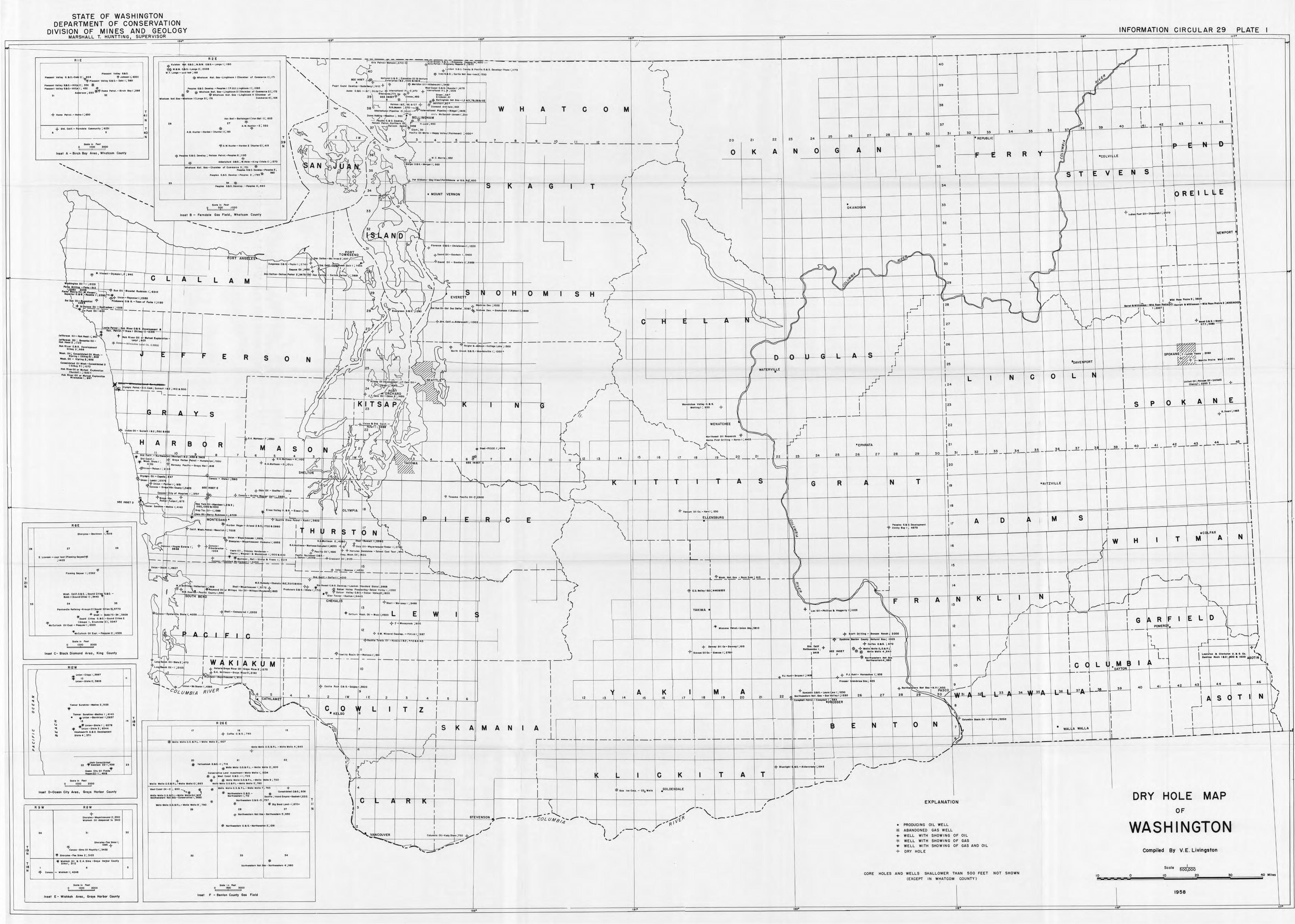
STATE OF WASHINGTON DEPARTMENT OF CONSERVATION
DIVISION OF MINES AND GEOLOGY • INFORMATION CIRCULAR 29 PLATE MARSHALL T. HU NTTI NG, SUPERVISOR ·-==------------------------------- ----''~"0::0---------------------------------------'"r''"--------------------------------- ------""r'0'---------------------------------------"'1'0' 0·-------- --- -'--',
R IE
p1, .. an1 volloy aao.
Pi.o,0 01 vo11,, 0.11 o.-C• I 2 ;io4 -?" Johoo .. 1; •oo! "f Ploo,oot 'o'<tlloy a.110.- Dohl 1; no
Pl ooooo1Volloy0.ll0.-Hilll !i H6 * Pit•••" ' vo1ro, II.IIO.-HIC10 l ·, 4~2 ~·-
.. ,,. •• ; 2110 ~ Ho, .. P"'OI - Bi re n 110,, ;e11 s ~ "
+ Hon, F'llol. - Hoinol;su
• + SIi, Coll!.- F rndo lo Co.,munity; IIZ~I
•
T 4'
N
T 40
'---------~-----------~ · ~001, ;n Fool
" 1000 2000
Inset A - Birch Boy Areo, Whoteom County
....... , .......
.... ... .... ...
.... ...
----J R2E
--- -
'*- K.rlohon "I". 111110.; ht .e. M, o.a a.- Lo••• I ; I te o ~ M.&M. o.ju.-L•••• 2 ; 2008
w. T. Lono• - <oOl leol I 168
"* Whotoom Nol . --Ll•~~l0<0ni I ICl>ornbu cl Coninu<o l] ',111
-pin G.11 0. u .. olop . - PtO~IH I ! P .Q.o . Llngol ...... 11 ; 101111
; -(f * W""'"""' Not. Go,- Llotbloom11ChombOt ol Com.,..r<>t2);(72
{(- w~o1oom Mo! , Ou -Ll•1btoom 4 (cu.,to, ol
... Ol<Offl N.01 . a.,-,
~•• lloll-llo11oln~o, l(YonBoll 11 ; 80~
" " ,..
,. A.W. H,nro, - ""''""" I (H••••• I) I ,911
~~ -W. Hu"'"" -Nord oo ~ (Hunlo,fl ",415
>q, Po>( 111 G.9.0. Ponto.; l'allcon Ptl<OI . -POOPlff 6 ; 119,
*
"
AMeto!or4 o.e. a. ; W.~•I• - Kl•t !(Halo I) ;100
W~otcon, Hot . OH - Chofflbo• ol Co.,o,orot a; 101 1it POl>PtH o .ao. 09'tlOp.-p .. , 1 .. ! ·, = ~,
Poaploo 3.110. O,,,olo• - Pooo lH 2 ; 178~-,...
* Pooolu GAC,P.,olop. • Pooploo41@80
T
39 N
l~'/---~---------------------J---------"T---r--T---i---T--h---T--1---r--1------i---1r-1---\~~1-1---r-----------T"\-- .. • I I ---====---:r,,C,,C,;,C,.,:,S,,,u,t;,c-;,,,,,:~•=•:•C, ,,,,a1a.:,O,,,S,;,rt,a::=-------- 0---=~=="-="-=-==-•---....--------~-----·---~-~-- --- ! ,,/ I :
""'"""·'·Rid,, •~} _ .. e.l 8~l' ;' 40 ,-----~----+-~--~----:-t}IL--=-t-----t--r .. ,--- ---r:s--1----~-----·~'t~.~ .. ~.~,=.= .. -.~,-'.-.=.,=,c.=,=; .~,=.,::c
' f1 40 ' '
" ~ L,nGlo• G80 [;nolp8P11<,1cQ•oC>ovolop.•no.,l;11n ( ____ \ I I - \
:if l•u G.~ O, C.r!I• Not h.,-,veoz ji,so J !IE[INS[T Not iono l O,l!G.;Co~odi11110il 8Vonturo I l- I . ,,•..,.,/ \1
: n10,p11 .. 1a2,1000 11oldl~ W-
Pu11•• SOUM o ••••• :. S<><ltrt>o,11 1 ;19')e -4- I 'l' I ztf. Me,ldio:, :, :,.i_:, :,.:,c,,:, c"c,:" c,c,cr:,-----+---+-~ ,, l-----~----+-6:;;i~P:_--t-----t----1--'-----L-----1 w .. 1 Ooooi o .ao.-~u .. 1or 1 ·,417e I ""'"'' o. aa. - i a.1; 3106 ·~~· ,q- " ••••o•ionol P.1:f~ 1970 4- lot .. oollooo1 P: L.f : 120ti l ...____ '1
' ·, c.-. . .... , •• ;n~ ~ ~f' o .... · se+ '\ 39 su l1NtET.\'t s,,..,.,·,4112 £,;cko~; &1 I I I
I' 6 * -I *-4 B•lllngao"' ~•too•-1,zaJ;11,n 102 (
'-.., r-,:._ Hol..,.,,11,z ; 1'50111127-.}- .:.}'. .~ornhort, . ' 38 I ._ '- 38 N.11.Joptu ;2,7o-.\'f._ O,omond dc,l11holo , U2 w H A T c o M \ I
.) "- U11tr..,llo I Pl,olloo -J · 1000 ~'9-'intornollenol Plpolloe-Rldg•I ltU /
.," ~ '" 0.,.,Moldi"I!- lonlll 9G$1' + ~•c•o MeOo1<>10-Jon..:.1,2,;,o
1 - '.... / / "'
00' .~ELLIN( HAM
_,- - P"ooplu 6 8,0 PonlOI', ,;>c.C<'"c~+c~~---+----~f----+-J \ /'_..- ..rl r.=~' '\ 3;~hooo ~;..~:;~~··~,~~,.~J4, 8 H Lu
1«,4~0 '-..._
I ~ " V I r' t"-- '\. V--, c10,-, ~o ) j '-~<:::i.., I / I 'I, Po,11,~ OM w,111 - flop" Vo lloy I Fol,~•••• t ; 1000•
I 2 IW )... 2 \ 3 I 1
\ ~~ d ~ V r::~-';,--/ ~ - ·--- 2-t--6·+-~-L- - _,_ - _ ,_ - .!_0 __ 1_1 _ - _,, - - --!- - - - -J ! 20 21 22 " 24 " " 27 2B 29 ,o " "
0 K A N 0 G j N 36
I ' I " " • REPUBLIC
-
·-
34 36
R R I
d L-il'l"-H,------,l----i-----r -I
37 !
39
•coLVI LE
I ,o •41 •
I I I
I -"·~2'------J-~4;>c.._-+- "·~·'---t--=4=5-I\
l I
-• •• -
i -<,"(.c--<J 1-----1-l o i o cf\ , - , - +---+-- --t- , s T ,_ V E S : 11,
"" ''---"'='~ ,)? ! "'J ~ 'le,"'"'"•••a,>',o•le.,oo""'°'"'·'•l,000 'S' K A G I T / ~ \ __ l _LJ_J_t~t-~I -+--t----+---+--\--t-H--t-t-____iH\1;--;1-~-t~\11\ c·· I 1_"_'-J: '7 ~ 34 I I E • MOUNT VERNON 1 ·1 o R E I L • 1
I / ~. \,\o\\(\i--- i------i---t-__j__.j_____---i ( "'-, \ . " ' . I \ J..S \ • ,, I __jl -i---_;_---+----------1-~, ..... 9 ···~90 ... IOFO ,' - ____ J,-,-, ---1'.... "/ / ..;_'--', r) ! ___ ] __ J ___ L __ j _:_':"~·:·o:·r·:' __ J_--~---l---t~---~l~--{---4---~--f---~c-_j1_l_t--1---.;:1-1-lnset B- Ferndo le Gos Field, Whotcom Counl~ ___ \ / \..., l ,
1
_ \I +1~<11ofo<1tOI I-OM.,,i,hl;~•TO
L----~-~-------- ------~---- II \\ ) ,,.,. ' / 's---'<;f--- -----1--,-,--- ------ -- -------"----; ....__,\_ 32 '1 , ' i ( - - -j-----t----t----"__::rr---':,-. --. - - -- - - -- - - -- -- I 32 : V ..----,- ~ • , // \ A N D .... .__ ' NEWPORT l
I! ~ '" 0 ~\t---,.-, .. -... -,"-+-,,-_ ,-.. -... -_+-1,-; .,-,,---l--1---__.J '1,\ '"",· " ! i _ J__ __ -1----1----i;:
To '•'s',T•o '. ,,-- > ' - I _ _ _(__,,...,'t..--+---i-t-----t----r---t___J I ' W '\ l \ \ ?t•••dOII - Geodwln1;~400 { I
Y {" Daito •No lnsou ;,oo ~ \ - ~\ \:1/--~'9=.s.., .. Oil - Gou .. 1n j2 ;uc, '---- \ '\..,.' R' W 'i I
< \
"u' AN /
- ------ ------- M '-···"'-:::::·~:::.tr-< ·-~r:1 ... ,;(', ~ \ - , i / "-, c-~ - ,, I --::7~bcel?'r1L+----~--t-1----1~---i----ti1~-
~·"""-~ ......... •;~" .;-, .. -;: ·'1'"'t ... ,,; ... J ~ J '. i' __, \_ ~) - ;,. --~ - ~~-~---'~r')__,_-__ ,L _______________ -:_-~-~-~-"--~~=~~"'-,-....- -·,; \_-_:---~,-:_-_..,,+1-~---_-_-_ ... _'!ltf;)=====:==-~«"'-:,,-,.+;//r"-,1"_~:·:J~};:}"~::!:~====i;=====I;==~:;~{;_2_9-_- ;l ______ -'.i-1_-_-_-_-_1:=====1+·-- -"I(\ ;
I ~ ,/\J!-.,)"t--- +_:::,_/l-_./- -l;i=-,v-,-,,--1T..,;.:,,----/, V n V I s H ,,,_,> ___ +------- ---- ---~--,-r--.-----1"1-J.---'..l.i_\.l-----~----\----.l,-~ -1------1-- -t---:r-- :\._ - ! //r '\ \ .,,.,_,., .. ,;noo
~ M • ','In-I - 011"'9!0 I , ; 140
11---------~ ,;1.;;;; .. ;;;,.;; .. -;,;,, ~.,.;;,.;;,,~+---/----_j__~C;___~L~/_ A __ _ L ___ L ___ A _ _ Fe,11 llrlllin• f a, 2
M f'orlt~~l,!eo,f:V.wino,ni; , ho 011
1-6100~11 lludon 1; 5210
BIJpo,lor 0.19.- ""Hile I ; !510 •:'f
I '-")\ \'I. ', ( I 1r"'~-t--- - +---,.- .+ .. -J,,-.c,-,,-.c; ,c,,c,-1----+-------------- ------' \ ----.---i-----,,1-----y----..---- --kr\' .. al~ __ Jl ___ t'--L---t---~----~---~---~K:!__='~J~---+~-2-·--~~---t----t--'l_,,,!tt--1r ___ i _"_.:·-"s~ L--i-_-1---r-_-_--1-_----'~"'"""_·····'! ,",i'"~~.IL=-_.., ....... ;",",,','1,01nt,:.._,,rr~II • Wllll• ... ~·1_1 Wlkl !IOU Ptolr\l• :r. ;•o«1•007lll --- - - -
01----1---~- --+-2-8-'r-.J );0l>'.;;,.,, .. ,:,;~///''"""("'~''"'' i''"'r>-'"J., .. -, ....... ., ...... .,;,., () '> " ~; °""' 1
"- ' -- - ·, _,., '
\ / J ~-{,- Unlon-ftoronlor1;zeno 601 \ o'.'Zllluhl.i ~ P'"""""" o.o, G.-r ..... 01 F0<1to 1; 1120
l..J' s, -~•l•u 011 - trod- 1 · 100n -*C.~11-:"ecro- - -' - - - - - - __ _ --,... __ _
---------
Jem ..... OH- lloh IIMd r; ~01
J1""""" 011 ; •••Jlla 011 _ Hon Hood2 ill20
Hoh Rlnr O.!I <J. c,,otopoton! 011 .. , 2; 8Be
loo llo Per,.., . h RI .. , 0.1 G . ..,.10~.,.,,1 I :t on. ro • - 9Jmo I (Gllhi I) •21H '--'t- --i---1-----~ + Ho~ ft"or CII or Muh,cl t1Jlor tl•o-
l.o•y l ; o, * tin lo - Mllwou~•• u "co. l:uoo
W..on. 0;1; ConlOIIO•tod 011 wau . • KIP ll n9 I CGHlt*f31; 801 \ -W.oll, OU - ~loUnv 2; 181
.. Conaot ldo!of 011 Woah - ConoatlloPM 2 \
(o;n,, 5); m10
Hoh l!l•o,OJI •• M.rhaol E,,00..,111>1> r:=:::'J---- -i-----..L-,f--- L ______ _ C~••ohill , ; 1,;00 t \.
Hoh Rln,. 011 o, w.,oa, hp,.,011.., Mhoultn I ; 1197
w- limolo ~o1rol .• (;_ t; . CooO i ~ulo oulr 111 ; 141~ 11 ,OIO
~ ·---- --, I -- - -
E
-----
~/ 1/., \ 1-- ------,!-------- -------------<, - r I
..i / I) ~ >t/- f<>l!llor 8, J "i" -Cel100• Lolli ; 1~00 ...... ~ ,J 1126
J__ __ J' {}; ( " ~\:1 ( }= (I ./ '- """ '"" '" - ~"""" ' ; '°'Y ; - - ' ' • ~
>/ ,) ,J
WAT RVILLE I . ~
R 5 0 N
r I
J L N C 0
•oA\IE PORT
L
w,1 ; 1•001
un(IOd OIi ; .... ,._ 011-U•l"O ( Doonyl; 2250 1 ' ; 1 / ,. iJ':)o:i~;:r~ I < ·,:,0 ~~ r _,-'\, L_--1,._----1,-_---l---+--H\---1------\f----+---+------1,-------t-!---::::"n ! 2•
})
~O~CHA~O I '/ / F/' I I
- - - -, K , '~r· '"'"s"' -A, ... ;P .-. 7~ , ~ ;'f--------ti,---tt---.------t-...-f--- -k ", '\.., : 1 1 I E ft, ' ' I" I N ;; ' ... ,,,. .. ""'' ,... JI 1_1_1_1_tlt"_l- t-t-+--l--+-+-4-~-+~S-+J:P'_f0L__II\._A\-------"!N::t~11 I
I I
• ,: A V s
---,---S.... f-,__:;:::".jj_A _ _ ,.,_/ _J__J' -?-~:,~--, ,lr
1
7? - '-v-\__ WEN4TCH' ! ~ ,.r _J ___ 1 ___ l __ JL __ j ___ 1 __ 111~22~-~---~---+----~--~---+---t-+Jr---t'·---t---r--1,--1---1--1,, -rL 1 .,,- y / .~ u ) \...... N~f tbut OU Ruooro~ + ,J I I
uv) \~_,._ ., .... ~---t-----i------1--;-----i--- --+-----e--- -- - .:F"---~ L_ Nert<tFl .. tO, llliog-No,001 ; ..-011 ~ : !
I I
----r-G.A. MOtlmoo- :r ;2,r;o
~\-'1'-"-'-'_"_-_,_"_'·1·-·-·:.:'c;:•:":.:'i!-'- ---+----~---
StE INSET o
21 \J "\_.., \....'- •EPI-I ATA 121 37 ' 3_ ' _ ___12_ - L.-~-' 33 34 35 _ 1...--EIL----- ,___
--... ' 27 28 29 '30 31 32 ____ _ _ .__
15
•1'
H A R B I R A s 0 I.N I
I I 10 9 I • .,,,. .c,ur.- ""' ... ••,· , .... ~l> ifTa.2 , s39a 1-- •8'--L 1- -7'-_JC,-- -'6'---"T- ~''--.cc,;;;;· -'~4'.,"',J--~3'-,,_.,-J\--~li..--';
Sr-Com. - G " r -"'- O . .o..illnrtmuo-4·,110 2
.:;: W••h . Sta,0 1 ; j roro nort.r,, 01••1-- Huni,"'r P•; IOOU J -y- ,,f{ •11 ,0 I ,,,,,, , •. 0 I + 0 . .0. .MoUmon -~ ,- 1~<,:) I I oo .. ,c - ,a,, Hbr I t "B
~-;•rPolnn I ; 2 oi .I
" ' 3 ' ·- • • 10 " 12 13
,. 16 17 " SH LTON
TACOM
~ 01y""'f 011 - i:..,.w.; r, '\, '""'
4' ''"''--, ~ .__ __ ..
~··~.)'.~~.;.':;,,.,,,; .. ,. \ ,/ ~ I~~~. 6 , ,. ~,--~ 1 1 1 I A -> G R , N Con•••~~: ·~:;·::~~:: .. i~;m? I ~Ohl•Ol1-9 .. rrw1;11102 ~ 1 i9~~< r..--.... \. ___ °' /- -----1-----_j-----+------ -f-------l I I
t),-t--~ ... t.·.·.~.=!",.'.-" ·~~"''1-C!.~"--~ ~-----1--_j't_>Ce•c···-~·c-co•!!ll~!!!•\!0t l ;,sMI' - ~ 'L__ ':---j- ----1---.:.~---f-----+-----t-----/-.. __ '_'_"_._.--j'-"'_'_"_'_'_"_·1.+·~·~'~'-----t-----L----_[_----J' }·-,,--~~- - -------"·-+----f-- If , I
) ,r~--,.Pot r-1T.1io, 1;n5 I , - I \ , NH lMk ,0 11-AbordHn I a, 3 ; \ j'- _,, ...,_ .._
t1 ---- ------- ------------------- -----k~'~•:•:"~ ' ="''"'"~-~.4ioo 1; 4140 ll!0,131011UO ' IS ) / , • I \- 18 I OroyTo~. il-11159& . EltH~oll•~O
1. 1110
1.- E1ma 1;71)o OLYMPIA 1 '\,, , ~ S ,' - - ...- Too • ffl 011 CG. - !(>," I ; 5l0
- M;TESAN • hottlt Er..o ·P.,..01 - ••h l ;Hu \.., - 1 - -. - / \ 1 - ~L ENSBURG n I A Q , M S I I
T 21 N
T
" N
T 18 N
"
"
R6E
" E. LO"I'"' - oool toot IFlo niitr9 <,oyH<l.q.
: 140ll
·wuh _ Deli r . 0.11. G. ; Sou", ~i t i•.!. G.I O, -Bobb l (Souaoc1,; .. 1) ; M•O,..
,.
"
" PanhonOI• fto f;fl;og -~rouoo 2 1Souoct i11u ll)i l!1?0 .. + S~tll - obbn - 34 ,3W9
"*soun~ CIIIH 6. 90.-3oond0il;u2 .Y<- (t<rouoo 1. E••ffloln 2); 5047 Y 1.10 Culloe~ OU t,pl . - P<Joq , ;,,, 1 , ~023
seoio i~ Foor ,coo
Inset C- BlocK Diomcnd Area, Kimi County
A12W
+. Unio• - Clopp I; 5997
-'f' _ 10 un ,oo - s,01e i; ,so~
ronnor s .. ,n ;"' - UNllno 2; ,12~ .,. Ttono, Sunolt!no-Mo~lno 1 ; •••o
• 'fe Union -earnltlHI I ;tll~1
" ,., ... Unlon-lllolo I ; ene 'f Tunio-8tol0 ~; 11~44
Ho.i, .. o,ia ~.ao. co.01011mon1 Stolt•; 37H
. ,.U!th Cooooll40to~ ~2 "1'"8"•0000 22-,;•3•1
o....., Cl1¥ 011 F;,141 oo I ' 4S l8
Soolo lo fut
'Ccc~~"o'a'~~a'a00·'
lnut 0-0oeor, City Area, Gra~, Hcri;,or Count~
R9W
..
'
RBW
... s,..,,.., • .,,r"'""'"""' 2 ; 3310 w1,M,oh CU ~Hpooo~ lo 3410
" Shorplu-Foo "'"''';
>If 139$?
Cooooo - llin, Oil R0yol!y 1; H,2
-'f s~u~l,o - Foo s;,., 2 ; 3103
• "</- Co._ - Wloh~oh I; 4248
S<~IO lo Fool o 1000 woe
lnut E - Wishkoh Areo, Grays Harber cc11nty
"
..
"
"
T 1B N
\ _____....., \ ~ h•bor "•i•• .l.r!ood z Is; 1700 a zeso [ •
17 ( ~ - t' ,,I (. I J\~I'.:. Po<>0ln o.a o. o,,. ,opn,onl I 17 '.
, ................ -~ ...... ;,~:.·- ........ "" .. ;"'\ i H J R T o N ~ J ,\ ' r , ........ ; .,,. : ' r I ~I !h,p1 .. - wl r .. •oou .. ,c1,moo 11 ;ee:i~ j <l Wo!!roo n 2,4 0) :fliil ~-To ........ rn,r.,-..<o----'')-/<-----1------/-- - ---1-----hL ____ J / --- - - - - -- I I ,..I
) LG,ooco.•1<011on!o!U• I " "?' -}-C~nooo- I / ._.,_I.Oattmon-!lott .,QnC.. p~oul,'!05~ -<lo:? :ioh10 11 -\llt~o,~o .. JorT1-,I 27 0 / \ I 1• c,-, .,.1 u., . E,~ ... i.. •• ~ .. I; 1 1
r , I • , roco. l'Hlo 01 1 , ~ni~r,~ ~ondo,oon - .A.-4-F'<tol 0 11 1;1 &00 r'" -4- ""'""''" on~oton, - School C.01 Toi! .~91 '-- \
w H I T ,cc
M A N I I I
I ' r----t-t-----+-----1---,.---l.,;·-;.~;·~·9:·: 19:I/:·~:~::·: 1:::.0.0,~ :::~ P•c.1:..~:~1•·~ o• - c, ...... 6,1:\~:·: OIi 't 00 I ......_ _ _..._,_ I \.. I
..-- - ~- - - _ - - _ ~••.!!_-Pi~~c, ., ., 401, ___ ' :__'-I IOI I \.\ --+- - I l.lnlon-s lth1;4927 -------i > I I + ___ ------3'.!'._•l!t:.!!·~ ,;4,,o "'., _ /---- -1--- -" I I /! 1
I/~-,, 0---++.c--( ' • I - - =f"''- , - \ 1 - -----1--- -----l.---'' I _./~-r=----W,---+--t-----+--+----t-- t-____J11
-c -:./--= --. .- \ "
c....;: > I j Y · - 1 1·4cm --. ----._.,. .... ,.- i 4 ----+------+-----f-----+ -i}-w0,'!:..'!",!:.!!•.:..A~m_;_!!!..._ ___ _jl..,[_ _ __ .j... ____ +--- --jf-----c,..,ci-----+-- - --- - - - -
fr 111 .0. 1:onnodp Choholia 11u:,ooos1600 I I - - 'XI \ : 6r flt:s;1<•1~t,1oon I; eGB s~,11 - w.,.,~., .... , 1 ; d 72 "?" I "?"-¢- .:~/ •lh,.oot O.llO. Oouloo.-L .. mo, 51oo~oro St•1•1 ;211ee ;> <, /
('"' ,....._ _ __/ ! ,4
"?: /•~aymoM 0 11 •• \llll lopo ~b, 11 - wmoo, ,,, -· , 1., ,,, Prnduco<a O.lll ~.-stole I ;/71 f S..lur Vo FI-, p,,,.i,o-n1-so1,o, vo11,, 1 · 1050 • , ~ ttw o,., P<I -, , A ,--n , • J E.o. ar,n,11111l;44&&=t5 - -· · - 01 • ~•••1,1 : llllO ( i'if. So lu , Voll11 0.9'3.-Soln, Volloy! j1,oo ( ~ 1,.,..,.. H BE DI I ;~;::·~;~-Ko>'loo 1;9 4J , (I ,----~-~----+-----/-----+-----+----- ~----+------j------1\----= H
-<?"anon - Mo r ono, I ·, J4ee F R I
A N K "
L N 1
\
" I • .. Shtll-Comon,IM 1·,z93a I + L E (' c,.. o- "-,,.-m. ••••• •·· ., •• --1----Ji----1,---_J~----r----t----n-----~~-·::::.+::.:".:.:~_;::~~~c,-~~l---~l----~'1----H ! ~, .• ., ~,~"'" ~•••. 011 - ''"I• i ;ewo :i" ,,,_,.,..,, .. '"""" ;"" "-- ~ ) /,, \ \ G ~ R F I E L D \ \
YAKIMA •
I '
I -{>- ? Mou,,ou ; aoo /
12 I I -¢- 0t'. 141 ntrolO .. ,lop . -~h 11c•l;lle7 ',
I '""" . ... ·1= 11 •• , .. ,
I II \
r
____ J ____ J1----~----i----~-----i"' __ ·_··_·_·--~~·-_, ___ ,_ .. _ .. _ .. ~·~;_ .. _._, __ ~----~----~11L---~.,,c--.;.~x.:;;.;;t;;.;;;,;;~;'-J~~---_.~_--~-12---+----t---~,~"-'-----r---4-----~11----t---1r---~r--1
-,- ~·~,~·~·~·>,(1._ ___ -1-----+----i"~,----1-,-,, -t Scott o,) Hlna - a, .. .., "°"'~ 2000 l._.,.,.........._ __
I -V apoltOu .. ftt.• c-i, J1otur•1 GOI; ' ? O' ~ 1
1 I - - -- ;1
.a}- ColPu 0 .0,0 . ; 11~ __ _)/l ___ J ____ [~--~----~,,,,_~+---~----~---+---~---~t--_1 ____ r.'.:l'~-J1 ___ t_1jC~t~~;j~~~;r~ ..:,.- 0,0001 cu c.-O••••r1,111e ,it. ce111 ... . I I 11 I 1-~ [ I Rolll,..,01i,1 ; Y *,:,,¢,.IUllaWolloO-,G.t.P. ~ . -y·r
-'l' ' ~ o•>< , · o· ,,oo OO S£EtN:5t1 "'- 'l'o lloW<tllo4 ",U40 /" I \
_ A r 5imc~, •- •••oo, I" ~
tlo•v:r:~o11-S1oto2 ; &1o I w-:-Kl -A - J M-1 - - - -- -- - _'.::~~;1~e~1-:011_"_'_'_·.ee~ --- - -- - +-- - -1-- - ~.-- - - -- - - -- - - --- ___ ..) ----1-----~-------jl _____ ~-----1--- ----+-----~----+-----+-----/-----+-----·f-- - - - t--'---i-~ilt 11.,t ... .,. ,..,_J, __,f \ L_ _ I ;:::~::• ,_:,;1:~•;\";o~! ~~~: ASOT~
t, ..... TJ,.,,,_,,,,,, I K I --1 I ""'1""'"'"';"' 10 / I C '1~L:__l~M~~'~'- +''---- +--t---il~t--t---1-1 ~ 4- A,10,10 G••r• ~1 • ., OIi a,0 .. ftlnr z ; 1z 7e I JO I I • '" N I '-CA \. . ~ r-< ,i.,":~.,-·a· •. ·.,',t",.,·.· •. ..:.· ... -.a-~,; .. _.~·m _·t··~ .. ~·~·~'~·w=-i----ti--,---r----~----+----t----~---,~---~-----!L---J ____ u I r----l-----L----~---~----~-----~----~----~---J-----f--"..'.::.":1:.'.:".'.~:':'1 i----~-'9-::::::=E:::::::~::~"---f---t/4----t----\1-----t--;=-::oii--'~----1----i----t----r-- AYTO '1 "'.:::: ,-' - I ... . ' .. _ ~ I '·"· '"" -....... ; ,.,,I ,. ' ·"-,..,_ ,. ........ ; '" ! -- I I I
, C,:,:. •lon•Mollovron11,45BS .,...,. I ',.coolloRooO.a(l, - Qul~loi1·.~1;oo I '1 PrHnr,ond•lowoo,;~zn \. 9 _..I- I 1, 42 4~\ 44 ·
46 /
'coLU"BIA RJVER 9 I I V ~ ,+lt0<lilwUl":"NotOu - 11. P. 1~1ioco :.--- =- Hl."---JJ --.... - ~r-:~A-+-b'~~--1.·1-c'"'-J·11,---,--·3§_W-- '''9'------t 40 • I I '"-
A • I I r,
"' ~A-TH: .l'-~-·-...i_ ' 2 IW IE 2 3 4 I ' I " " 'I " A" .~ " I 1B M 19 ~ 21 22 ...... :~:::·:.:~: .. ,.,::;,,::,\'/,~'.. " 27 2B 29 30 ·:;, "'31 • ' 33 • ,. •• 30• I I I A s C T I N ; ~ - . - ' I 6 I "~ • """r'··~":,· 'i::lsER ' ' I I ~- -----1---- ---,- - ----,--;;/
~--~-- ----- - ----------------------'..::_:--~,-~,.-0- '_"~' -'-~- - ---1-'---L- 1---' T z i ! ~--~----l---- -l--- ---l.----1--- - '-----~1-----1-----11-----l~-----t----Jl-- -Ji ___ _j_ ___ -+----+---~---~-----\----iJ'~:.-~ .. = .. = .• j,.~,=.: ... ~.: .. ~-=.=··t .. : .. -;: .. :,:,-r----r---r---t----r--11------' I ;_J ~\
R 26 E ~ I I I I I I \ I ., ,. ,.,,., ; : ,.,,., ., '~ 7 I 5 ( A M A N f A I I ~ T Q N
7 ~ti J---+---f----+---+--' ~w".:ALf A'._'W=AL::::'•+- -n -~~-...1\c-_LII ~-1--__.!.~~_i--~-'\'---i"i
*1
""'11~ Wollg O.G. 8 P.L. -\l/0110 Woll~'; 1~07 ~.t-\-----1.----+----+----+--;, L ,'"-~----~~;~~~~~~~~~------------ __ j,l=~~~l=t-~===-1-====t==~-=-j-=~-~=1===~-~1-=~~=1-===~J·~===1=~~=1===~j-==~~-~t-=-===tt-~=~~-~~r1~~~~~~~~~~~~~~~~~:1f~~~~~~~~ir~~~~~~~~~r~~~~~~~~r~~~~~~~~~r~----_-_-_-~~J~',f ,,2?~" __ L ___ J ____ J ____ 1 ____ 1 ____ L--~-l.e~~=r-·-===---·-Wol lo Woll O. ~. l'I P.L.- W, 11~ Wo llo ~ ;e40 _
.,. ,, lr",-+---h,,-,,.:''._,,---1--------_-_,+:::~'._1 __ 11-
1 _ __J c---+--+--- l- - ---+---1---~e-------1----..!
1 __ _..J_ __ -1-- ---l-----l---+l---f-1
1 _ ___, --+-----t---t----t---t---/ /
" * Yolloo~o"lt Q, &Q. - 1; 718 I * lllollo W<tllo O.G.1!, P.L , - Wallo u ol!o 2; 8 00
woll• Woll• Q,(J.11\ ~ ct"wo110 1110110 10 ·,~B3
wu1 coo,1 o• -z ; a~o -~ ~
' " Woll • WolloO.~. lif,P.L.- WOIO, WOIIO~A;eo N«,.,wun,n 1<01 oo,-C<>nto,...,H .. ,,sso.o
Woll• Wollo J G.&P.L.-Wollo Wolle B ·, 7110
~
"
Coeu,.o,I .. L••• 10,,uniool • Wo lto Wol lo ,; I ~•
'J> + 1w,a1 Coo,t e .ao . - I ; 70~ * * wo11o w o1100.G.!:IP.L.- WOIIO 01109 ; 100 Woll? "'° ll o O.G. lllP.L.- WO II O WOII O 11; 780
"
""'llo , .. uo O.G. '11 P.L.- Woll a Wollo
* Mor!~""'""" O. &G.Northw.,t..-11 I: 71~
Nofl~wtoto,. O. lli G.-J .. "
.. s,0111, ; 1a1""" "'""'" -Goo<Mn1;2212
'" * !Iv 8ornl L.ooct- 1 l67Q~
" + N0<th~u tor• Not ,""' - """ "'"'""" s; s~o
n ,.
9calo I n Feet 0 1!'!00 !5000
Inset F - 9•n1on County Gos Field
T
" N
o _r-v- I ' ..----iJ • .. .J- I I I ,,,-,... ____ ... --\ ~ I i - I C K I T A T ~ BIHII;~• tl0.-.l.ldorcmr ; ·~4!1 I - -
I -----~,-1 -1- -~--.!\'---- ~ --l---'-------l--:'.:___---l-'_.__--l--_.__--l--__:__--l----=_____--jc--'-1----11----l--------\::-__ /
4
'
2
I I w 0GOLDE DALE
----i:r+-;r-- -il _____ 'f----- -J-------jf-------T----...;'- ¥ GU IU C p, - co
11
Welll • .,,. / --r--t----+----+----f------l-----1-----1-----1-----1-----+----+--~..-~
n " I \ ,' /-- I
\, - -,. I ---L...!... , " ----- ... - - COL UM 8 1 "";, - • - "---1-- ---1------1----..L---,,-~- [ fl. '"' .. - - -
'--- y''f1v ---t-----:------t----t--' -----t------''"T('-V'CES,N,sS,cO"'N'-">- - -
I
VAIIICOU\IER -- ,_
I
I c,1 • .,~10 01 1- ~ody(lj11o ; r~o ~/
- ---,-, -
1
' ,,.,- · ... .,-... ., I , , -,_
J.- - -
,20•
•
EXPLANATION
PRODUCING
ABANDONED
WELL
WELL WELL
WITH
WITH
WITH
DRY HOLE
OIL WELL
GAS WEL L
SHOW I NG
SHOW I NG
SHOWING
OF OF
OIL GAS
OF GAS AND OIL
CORE HOLES AND WELLS SHALLOWER THAN 500 FEET
{EXCEPT IN WHATCOM COUNTY)
1190
NO T SHOWN 10
111•
DRY HOLE MAP OF
WASHINGTON
0
Compiled By
Scale
10
V. E. Livingston
5oopoo 20
1958
30 40 "'111H
117°