marine sar technical - nzsarnzsar.govt.nz/portals/4/start/marine sar/marine sar...and our search and...
TRANSCRIPT
Marine SAR
Technical
COURSE NOTES
Technical Planning For Marine Search & Rescue Training Course | 1

© New Zealand Search and Rescue 2016
With thanks to Martin Paget, NZ Police.
CREATIVE COMMONS
These works may be downloaded or shared as long as NZSAR is credited. They may not be changed in any way or used commercially.
Technical Planning For Marine Search & Rescue Training Course | 2

Welcome
The marine environment poses particular challenges for the search and rescue sector, requiring personnel with specialist skills. New Zealand has an extensive and varied coastline, and our search and rescue region covers over 30 million square kilometres of the Pacific and Southern Oceans. Nearly half our search and rescue operations each year are water and marine related.
This course is one component of the training available to ensure New Zealand has effective SAR services for people in distress in the marine environment.
Marine SAR Technical is a foundation course, developed to provide you with the technical competencies for chart work, plotting and associated calculations.
This is a stand-alone course, but is also designed as a pre-requisite for further training in marine incident management.
Technical Planning For Marine Search & Rescue Training Course | 3

Table of Contents
Introduction ................................................................................................................. 5
Your Learning Outcomes ........................................................................................ 5
Training Timetable ................................................................................................. 6
Reading and Interpreting Marine Charts ..................................................................... 7
Plotting Positions On A Chart ................................................................................... 10
Calculating Time/Speed/Distance ......................................................................... 11
Plotting a Course on a Chart ................................................................................. 12
Using Tide Predictions .............................................................................................. 13
Leeway Tables ......................................................................................................... 15
Coverage Factor ....................................................................................................... 16
Plotting a Search Area Determination ...................................................................... 17
Probability of Detection (POD) .................................................................................. 19
Worked Exercise Examples ...................................................................................... 21
Technical Planning For Marine Search & Rescue Training Course | 4

Introduction 1. On the NZSAR website (http://nzsar.org.nz/Knowledge-Training/Start) there is related video information that you need to have viewed, and a downloadable self marking knowldege check-test that is to be completed before attending the training day.
2. It is strongly recommended that, as the tutor explains each topic, you supplement the following notes with your own written information. You will then have a handy reference for the future.
YOUR LEARNING OUTCOMES
Overall, by the end of the training you will be able to:
1. Read and interpret New Zealand marine charts for SAR planning purposes.
2. Accurately plot positions on the chart using navigation charting instruments.
3. Calculate Time/Speed/Distance.
4. Plot courses, directions and distances on charts.
5. Locate relevant information relating to tidal movements using tide predictions from Land Information NZ and tidal diamonds.
6. Use Leeway tables to calculate the leeway effect on any identified target.
7. Identify the relationship between Sweep Width and Track Spacing to calculate Coverage Factor.
8. Plot a Search Area Determination and understand the calculations relating to Total Drift Vector length.
9. Plot a Search Area Determination for the different plotting scenarios of LKP(target adrift) –Track line Overdue –Position Uncertainty –Time uncertainty.
10. Identify Probability of Detection using Coverage Factor, understand the relationship between single searches and multiple searches and the effect of different asset types or heights of eye.
11. Understand and explain the relationship between Search Area, Time, Velocity and Track Spacing.
Technical Planning For Marine Search & Rescue Training Course | 5

TRAINING TIMETABLE
During the training day you will take part in practical exercises that will allow you to progressively practice your skills and knowledge with the assistance of your tutor and the support of the others in the course.
At the end of the day you will be given an exercise to complete on your own. This will form the assessment for the course.
Please note there is a pre-course requisite. You need to view the two Marine SAR videos (SAD, SAC) and completed the related online tests before attending the training day.
SER TIME ACTIVITY
1 0800-0815 Welcome and introductions.
2 0815-1030 Review of pre-course work, Charts, Plotting Positions, Calculations, Plotting Courses.
Morning Tea
4 1100-1230 Tides, Leeway, Coverage Factor
Lunch
8 1330-1430 SAD, SAC, POD, ATVS
9 1430-1515 Assessment
Afternoon Tea
10 1530-1600 Wrap up
11 1600-1645 Re-assessment if needed.
Technical Planning For Marine Search & Rescue Training Course | 6

Reading and Interpreting Marine Charts
Because latitude lines are parallel the only measurement to be sure of is between those lines.
Lines of latitude stretch for 3600 horizontally around the Earth.
Longitude lines narrow as they get closer to the North and South Poles.
There is:
• 900 of latitude between the Equator and the North or South Pole. • 1800 of latitude between the North Pole to the South Pole.
Technical Planning For Marine Search & Rescue Training Course | 7
1° of latitude is equal to 60 nautical miles.
There are 60 minutes in each degree.
1 minute of latitude is equal to 1 nautical mile.
Note: A coordinate is read out as: degrees and minutes then seconds.
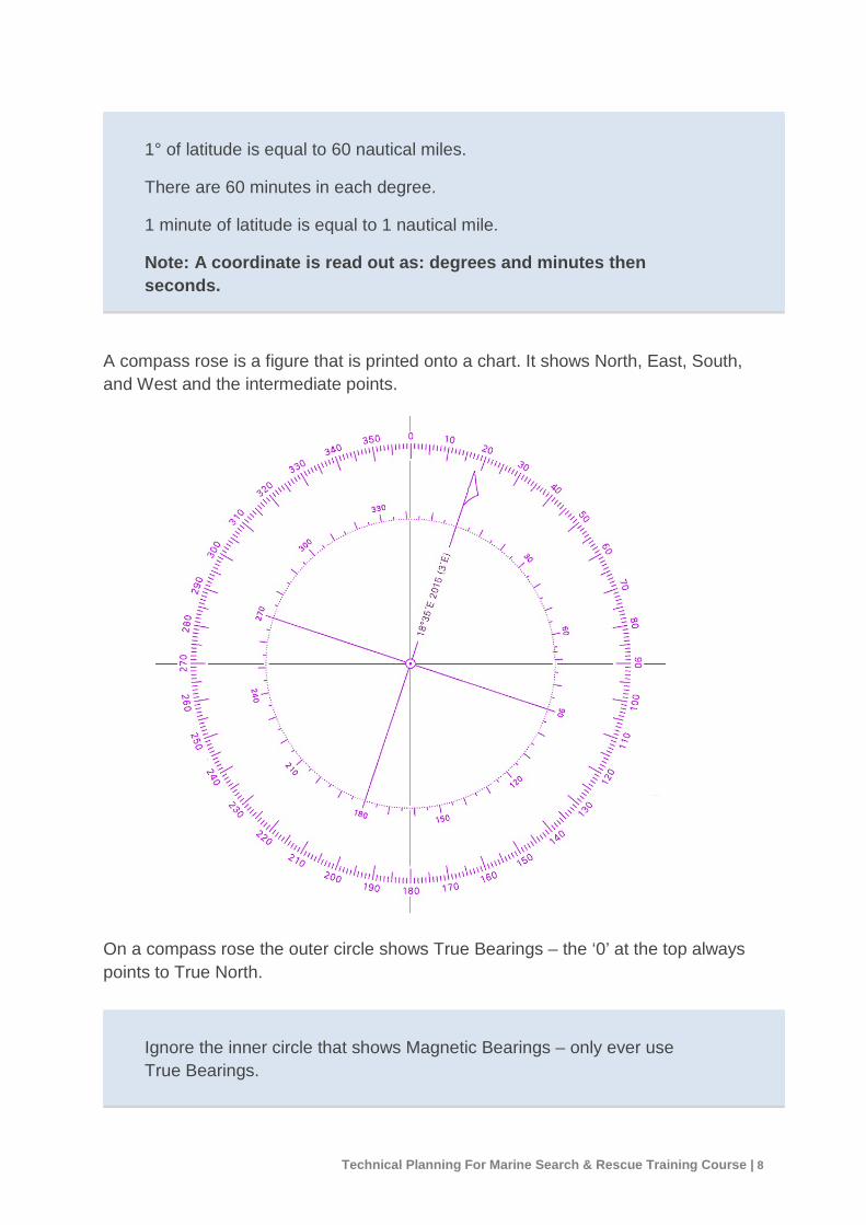
A compass rose is a figure that is printed onto a chart. It shows North, East, South, and West and the intermediate points.
On a compass rose the outer circle shows True Bearings – the ‘0’ at the top always points to True North.
Ignore the inner circle that shows Magnetic Bearings – only ever use True Bearings.
Technical Planning For Marine Search & Rescue Training Course | 8
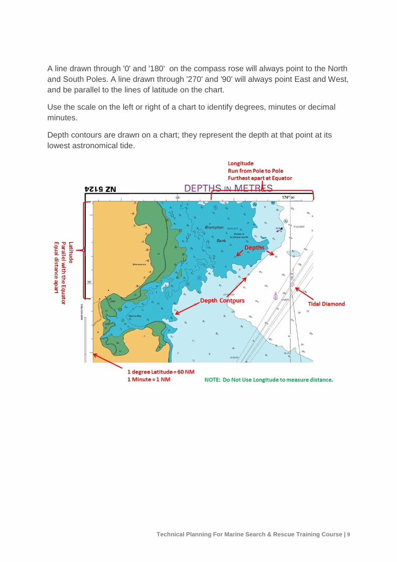
A line drawn through '0' and '180' on the compass rose will always point to the North and South Poles. A line drawn through '270' and '90' will always point East and West, and be parallel to the lines of latitude on the chart.
Use the scale on the left or right of a chart to identify degrees, minutes or decimal minutes.
Depth contours are drawn on a chart; they represent the depth at that point at its lowest astronomical tide.
Technical Planning For Marine Search & Rescue Training Course | 9

NOTES
Technical Planning For Marine Search & Rescue Training Course | 10

Plotting Positions On A Chart
1. Begin with a latitude position on the left or right of the chart.
2. Make a mark in pencil on the scale of the latitude you want to use.
3. Using the top or bottom of the chart, locate the longitude you want to use. Mark with a pencil.
4. Plot the conjunction of the two points.
Use the centre of the compass rose to read the bearing going to or away from the conjunction points.
CALCULATING TIME/SPEED/DISTANCE You can find the distance, speed or time data for a search object by using a three part equation. If you know the number for any two of the parts of the equation, you can then work out the missing number.
Speed = Distance Time
Time = Distance Speed
Distance = Speed x Time
An easy way to remember the Distance, Speed and Time equations is to put the letters into a triangle.
Technical Planning For Marine Search & Rescue Training Course | 11
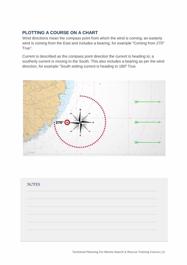
PLOTTING A COURSE ON A CHART Wind directions mean the compass point from which the wind is coming; an easterly wind is coming from the East and includes a bearing, for example “Coming from 2700 True”.
Current is described as the compass point direction the current is heading to; a southerly current is moving to the South. This also includes a bearing as per the wind direction, for example “South setting current is heading to 1800 True.
NOTES
Technical Planning For Marine Search & Rescue Training Course | 12

Using Tide Predictions
The direction and speed that a search target is estimated to be moving is a combination of two main influences
1. Tide / current.
2. Wind and waves (Leeway).
Land Information New Zealand (LINZ) have online information for Tides: http://www.linz.govt.nz/sea/tides/tide-predictions
Primary Port: A port from which the main tide measurements are taken.
Secondary Port: Calculated tide information based resulting in a tide time occurring before or after the Primary Port.
Technical Planning For Marine Search & Rescue Training Course | 13

Tidal diamond tables
Tidal diamond symbols on a chart represent locations where the set and drift (stream) of the tide has been measured or calculated. Each has a unique letter to identify it on the chart.
Find that tidal diamond reference letter and refer to the Tidal Diamond Table on the chart.
The Tidal Diamond Table will then give you the tidal stream at that reference point for different tides namely the:
- geographic reference point for that diamond
- direction of movement
- rate or speed of movement.
NOTES
Technical Planning For Marine Search & Rescue Training Course | 14

Leeway Tables
Leeway is the off-course lateral drift movement of an object caused by wind.
The authorative source in NZ for past and current weather records is MetConnect.
The Leeway Modifier is a figure that allows for parameters outside the Table.
The Divergence Angle allows for the shape and characteristics of the particular drifting object.
NOTES
Technical Planning For Marine Search & Rescue Training Course | 15
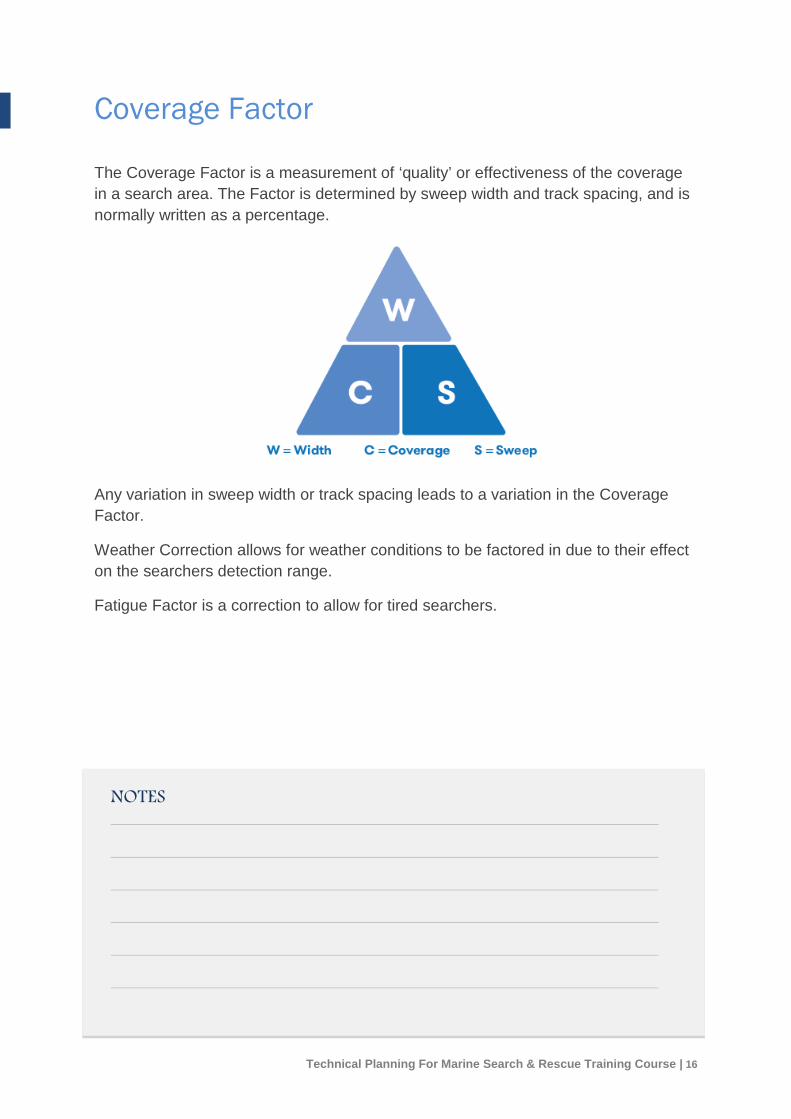
Coverage Factor
The Coverage Factor is a measurement of ‘quality’ or effectiveness of the coverage in a search area. The Factor is determined by sweep width and track spacing, and is normally written as a percentage.
Any variation in sweep width or track spacing leads to a variation in the Coverage Factor.
Weather Correction allows for weather conditions to be factored in due to their effect on the searchers detection range.
Fatigue Factor is a correction to allow for tired searchers.
NOTES
Technical Planning For Marine Search & Rescue Training Course | 16
Plotting a Search Area Determination
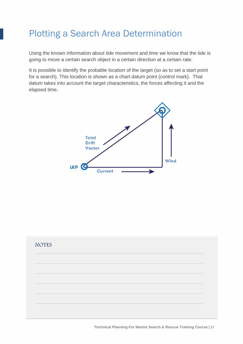
Using the known information about tide movement and time we know that the tide is going to move a certain search object in a certain direction at a certain rate.
It is possible to identify the probable location of the target (so as to set a start point for a search). This location is shown as a chart datum point (control mark). That datum takes into account the target characteristics, the forces affecting it and the elapsed time.
NOTES
Technical Planning For Marine Search & Rescue Training Course | 17
Mathematical rationale is based on the assumption that the target is not anchored or being propelled but simply drifting, and it will move at the same rate as the tide or current - the object will move at same rate and in same direction as water regardless of size or displacement.
Note: This is not a precise science!
The leeway figure is applied. Leeway is based on empirical evidence that resulted in a set of Tables, which provide Leeway Rates (speed of movement) for a variety of objects (vessels, rafts etc).
Position error allows for drift characteristics of the particular target and a lack of accuracy around the Last Known Position (LKP). The reason a 6 NM or greater radius is used around the Datum is to allow for position errors
Probability Distribution Density maps the highest probability of where the target will be in the calculated search area using a mathematical theory.
A Trackline Overdue is a technique for determining a search area based on the assumption that the target may have lost propulsion and begun to drift at a number of points along the proposed or intended track (course).
Position Uncertainty is the same process as described above, but assumptions are made based on estimated positions.
NOTES
Technical Planning For Marine Search & Rescue Training Course | 18

Probability of Detection (POD)
POD describes the estimated effectiveness of a search. POD can be calculated. It is based on the relationship between Track Spacing and Search Width.
A POD of 79% equals a Coverage Factor of 1 (based on the mathematical model for a single search).
Search assets of the same characteristics, for example two vessels, can use capability cumulatively and be treated as one search.
Different types of assets, for example a vessel and a helicopter, are regarded as different searches and treated accordingly on the POD graph.
To determine the sweep width for a particular type of asset, refer to the Sweep Width table for that particular asset.
Heights of eye means higher search assets can see further.
NOTES
Technical Planning For Marine Search & Rescue Training Course | 19
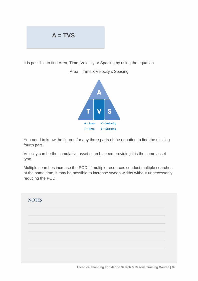
A = TVS
It is possible to find Area, Time, Velocity or Spacing by using the equation
Area = Time x Velocity x Spacing
You need to know the figures for any three parts of the equation to find the missing fourth part.
Velocity can be the cumulative asset search speed providing it is the same asset type.
Multiple searches increase the POD, if multiple resources conduct multiple searches at the same time, it may be possible to increase sweep widths without unnecessarily reducing the POD.
NOTES
Technical Planning For Marine Search & Rescue Training Course | 20

Worked Exercise Examples
Technical Planning For Marine Search & Rescue Training Course | 21

Worked Exercise Examples
Technical Planning For Marine Search & Rescue Training Course | 22