civilen 2410 (approved): introduction to surveying 2410 (approved): introduction to surveying course...
TRANSCRIPT
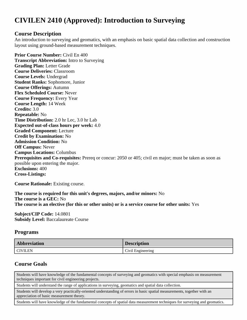
CIVILEN 2410 (Approved): Introduction to Surveying
Course DescriptionAn introduction to surveying and geomatics, with an emphasis on basic spatial data collection and construction layout using ground-based measurement techniques.
Prior Course Number: Civil En 400Transcript Abbreviation: Intro to SurveyingGrading Plan: Letter GradeCourse Deliveries: ClassroomCourse Levels: UndergradStudent Ranks: Sophomore, JuniorCourse Offerings: AutumnFlex Scheduled Course: NeverCourse Frequency: Every YearCourse Length: 14 WeekCredits: 3.0Repeatable: NoTime Distribution: 2.0 hr Lec, 3.0 hr LabExpected out-of-class hours per week: 4.0Graded Component: LectureCredit by Examination: NoAdmission Condition: NoOff Campus: NeverCampus Locations: ColumbusPrerequisites and Co-requisites: Prereq or concur: 2050 or 405; civil en major; must be taken as soon as possible upon entering the major.Exclusions: 400Cross-Listings:
Course Rationale: Existing course.
The course is required for this unit's degrees, majors, and/or minors: NoThe course is a GEC: NoThe course is an elective (for this or other units) or is a service course for other units: Yes
Subject/CIP Code: 14.0801Subsidy Level: Baccalaureate Course
Programs
Course Goals
Abbreviation Description
CIVILEN Civil Engineering
Students will have knowledge of the fundamental concepts of surveying and geomatics with special emphasis on measurement techniques important for civil engineering projects.
Students will understand the range of applications in surveying, geomatics and spatial data collection.
Students will develop a very practically-oriented understanding of errors in basic spatial measurements, together with an appreciation of basic measurement theory.
Students will have knowledge of the fundamental concepts of spatial data measurement techniques for surveying and geomatics.
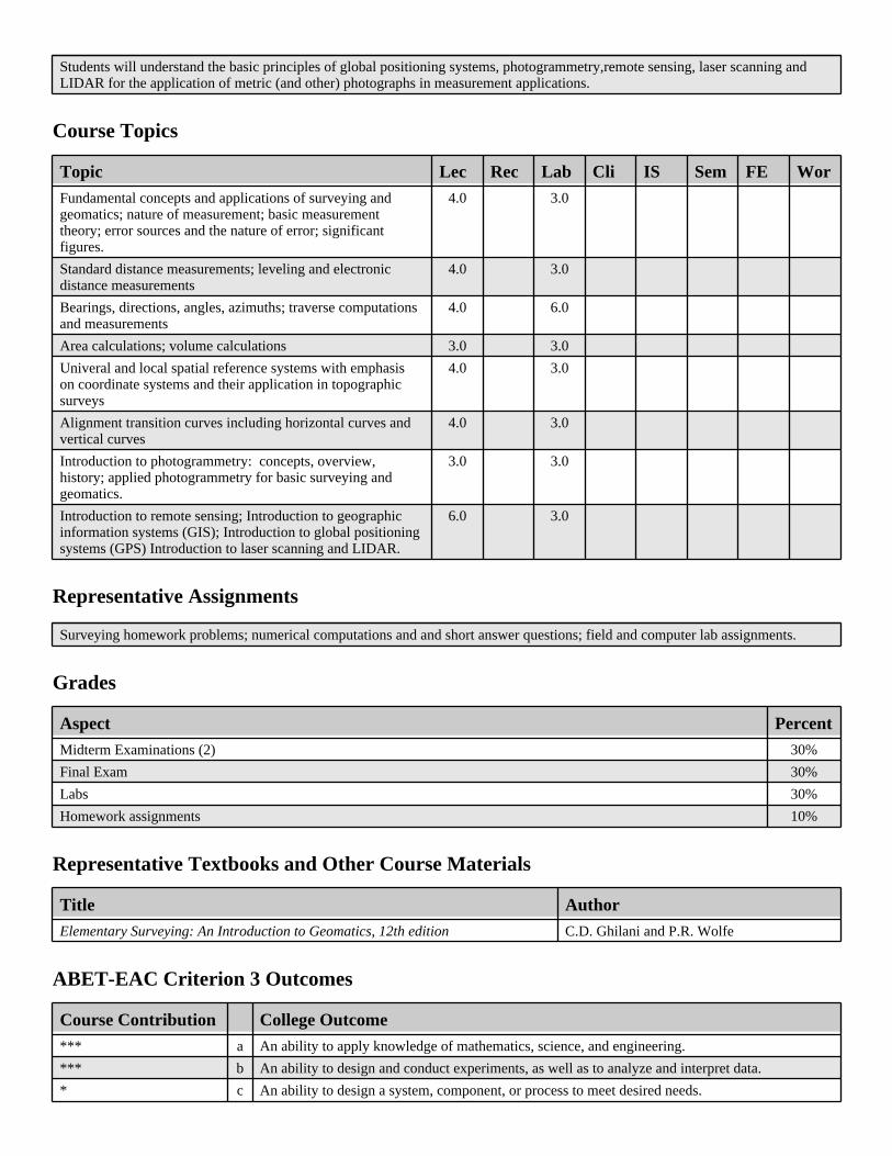
Course Topics
Representative Assignments
Grades
Representative Textbooks and Other Course Materials
ABET-EAC Criterion 3 Outcomes
Students will understand the basic principles of global positioning systems, photogrammetry,remote sensing, laser scanning and LIDAR for the application of metric (and other) photographs in measurement applications.
Topic Lec Rec Lab Cli IS Sem FE Wor
Fundamental concepts and applications of surveying and geomatics; nature of measurement; basic measurement theory; error sources and the nature of error; significant figures.
4.0 3.0
Standard distance measurements; leveling and electronic distance measurements
4.0 3.0
Bearings, directions, angles, azimuths; traverse computations and measurements
4.0 6.0
Area calculations; volume calculations 3.0 3.0
Univeral and local spatial reference systems with emphasis on coordinate systems and their application in topographic surveys
4.0 3.0
Alignment transition curves including horizontal curves and vertical curves
4.0 3.0
Introduction to photogrammetry: concepts, overview, history; applied photogrammetry for basic surveying and geomatics.
3.0 3.0
Introduction to remote sensing; Introduction to geographic information systems (GIS); Introduction to global positioning systems (GPS) Introduction to laser scanning and LIDAR.
6.0 3.0
Surveying homework problems; numerical computations and and short answer questions; field and computer lab assignments.
Aspect Percent
Midterm Examinations (2) 30%
Final Exam 30%
Labs 30%
Homework assignments 10%
Title Author
Elementary Surveying: An Introduction to Geomatics, 12th edition C.D. Ghilani and P.R. Wolfe
Course Contribution College Outcome
*** a An ability to apply knowledge of mathematics, science, and engineering.
*** b An ability to design and conduct experiments, as well as to analyze and interpret data.
* c An ability to design a system, component, or process to meet desired needs.
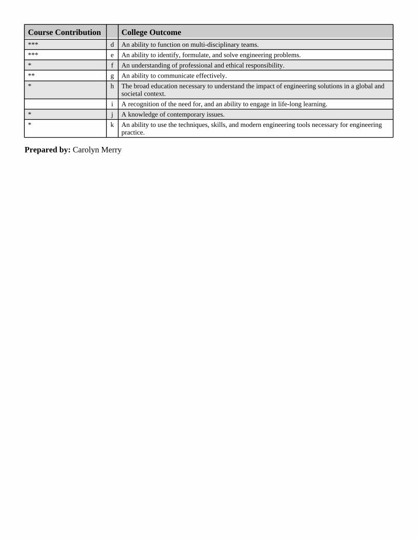
Prepared by: Carolyn Merry
Course Contribution College OutcomeCourse Contribution College Outcome
*** d An ability to function on multi-disciplinary teams.
*** e An ability to identify, formulate, and solve engineering problems.
* f An understanding of professional and ethical responsibility.
** g An ability to communicate effectively.
* h The broad education necessary to understand the impact of engineering solutions in a global and societal context.
i A recognition of the need for, and an ability to engage in life-long learning.
* j A knowledge of contemporary issues.
* k An ability to use the techniques, skills, and modern engineering tools necessary for engineering practice.