citizen science and smart cities - jrc publications...
TRANSCRIPT
2 014
Max Craglia and Carlos Granell (Eds.)
Citizen Science and Smart Cities
Report EUR 26652 EN
Report of Summit
Ispra, 5-7th February 2014

European Commission
Joint Research Centre
Institute for Environment and Sustainability
Contact information
Max Craglia
Address: Joint Research Centre, Via Enrico Fermi 2749, TP 262, 21027 Ispra (VA), Italy
E-mail: [email protected]
Tel.: +39 0032 78 6269
Fax: +39 0332 78 6325
http://www.jrc.ec.europa.eu/
This publication is a Technical Report by the Joint Research Centre of the European Commission.
Legal Notice
This publication is a Technical Report by the Joint Research Centre, the European Commission’s in-house science
service. It aims to provide evidence-based scientific support to the European policy-making process. The scientific
output expressed does not imply a policy position of the European Commission. Neither the European Commission nor
any person acting on behalf of the Commission is responsible for the use which might be made of this publication.
JRC90374
EUR 26652 EN
ISBN 978-92-79-38373-1 (PDF)
ISSN 1831-9424 (online)
doi:10.2788/80461
Luxembourg: Publications Office of the European Union, 2014
© European Union, 2014
Reproduction is authorised provided the source is acknowledged.
Printed in Xxxxxx

EXECUTIVE SUMMARY
The report summarizes the presentations, discussions, and conclusions of the Citizen Science and Smart Cities Summit organised by the European Commission Joint Research Centre on 5-7th February 2014. In the context of the Summit, the label Citizen Science was used to include both citizen science projects, and others that are about user-generated content, not necessarily addressing a scientific process or issues. The evidence presented by 27 different projects shows the vitality and diversity of the field but also a number of critical points:
Citizen science project are more than collecting data: they are about raising awareness, building capacity, and strengthening communities.
Likewise, smart cities are not only about ICT, energy and transport infrastructures: Smart cities are about smart citizens, who participate in their city’s daily governance, are concerned about increasing the quality of life of their fellow-citizens, and about protecting their environment. Technology may facilitate, but is no solution per se.
Unfortunately to date there seems to be little synergy between citizen science and smart cities initiatives, and there is little interoperability and reusability of the data, apps, and services developed in each project.
It is difficult to compare the results among citizen science, and smart cities projects or translate from one context to another.
The ephemeral nature of much of the data, which disappear short after the end of the projects, means lack of reproducibility of results and makes longitudinal analysis of time series challenging, if not impossible.
There are also new challenges with respect to the analytical methods needed to integrate quantitative and qualitative data from heterogeneous sources that need further research.
Building and maintaining trust are key points of any citizen science or smart city project. There is a need to work with the community and not just for, or on, the community. It is critical not just to take (data, information, and knowledge) but to give back something that is valued by the community itself.
The development of citizen science associations in Europe and the US are important developments that may address some of the points above. There are also actions through which the European Commission Joint Research Centre can make an important contribution:
Map citizen science and smart cities projects, and generate a semantic network of concepts between the projects to facilitate search of related activities, and community building.
Provide a repository for citizen science and smart cities data (anonymised and aggregated), software, services, and applications so that they are maintained beyond the life of the projects they originate from, and made shareable and reusable.
Develop regional test beds for the analysis and integration of social and environmental data from heterogeneous sources, with a focus on quality of life and well-being.
Undertake comparative studies, and analyse issues related to scaling up to the European dimension.
Support citizen science and smart cities projects with the JRC knowledge on semantic interoperability, data models, and interoperability arrangements.
Partner with the European Citizen Science Association, and contribute to its interoperability activities.
Work towards making the JRC, and the European Commission, a champion of citizen participation in European science.

Citizen Science and Smart Cities
2
Citizen Science and Smart Cities
Report of Summit
Ispra 5-7 February 2014

Citizen Science and Smart Cities
3
Contents
EXECUTIVE SUMMARY ...................................................................................................................... 1
1 Introduction ........................................................................................................................... 5
1.1 Scope and Motivation ...................................................................................................... 5
1.2 Definitions ....................................................................................................................... 6
1.2.1 Citizen science ................................................................................................................... 6
1.2.2 Smart Cities ....................................................................................................................... 8
2 The Summit ........................................................................................................................... 10
2.1 Citizen Observatories projects ........................................................................................ 10
2.1.1 CitiSense .......................................................................................................................... 11
2.1.2 Omniscientis .................................................................................................................... 12
2.1.3 CobWeb .......................................................................................................................... 13
2.1.4 WeSenseIt ....................................................................................................................... 14
2.2 Citizen Science, crowdsourcing, and VGI projects ............................................................ 15
2.2.1 ENERGIC .......................................................................................................................... 16
2.2.2 Mapping and the Citizen Sensors ................................................................................... 17
2.2.3 EmoMAP ......................................................................................................................... 18
2.2.4 EveryAware ..................................................................................................................... 19
2.2.5 Open Air Laboratories (OPAL) ......................................................................................... 20
2.2.6 European Citizen Science Association............................................................................. 21
2.3 Smart Cities related projects ........................................................................................... 22
2.3.1 EPIC ................................................................................................................................. 22
2.3.2 Helsinki ............................................................................................................................ 23
2.3.3 Trentino ........................................................................................................................... 24
2.3.4 Dublin .............................................................................................................................. 25
2.3.5 The Geothink.ca .............................................................................................................. 26
2.3.6 City Blueprints ................................................................................................................. 27
2.3.7 The Ecological Sequestration Trust (TEST) ...................................................................... 28
2.3.8 ESPON CityBench ............................................................................................................ 29
2.3.9 Cities Geo-Wiki ................................................................................................................ 30

Citizen Science and Smart Cities
4
2.4 Other relevant projects .................................................................................................. 31
2.4.1 Services for Smart Cities and Quality of Life................................................................... 31
2.4.2 EnviroCar & SenseBox .................................................................................................... 32
2.4.3 Policrowd ........................................................................................................................ 33
2.4.4 DeforestAction EarthWatchers ...................................................................................... 33
2.4.5 Citizen science: Evidence based versus emotion ........................................................... 34
2.4.6 GeoSmartCity .................................................................................................................. 35
2.4.7 GeoKnow ........................................................................................................................ 36
2.4.8 SmartOpenData .............................................................................................................. 37
2.4.9 UJI Smart Campus ........................................................................................................... 38
2.5 Brokering approach ........................................................................................................ 39
3 Citizens-contributed data: an engine for better science, sustainable cities, and transparent
governance ................................................................................................................................. 40
3.1 The Drivers for Sharing ................................................................................................... 40
3.2 To Publish or Not to Publish? .......................................................................................... 42
3.3 What to Publish .............................................................................................................. 42
3.4 Where to Publish ............................................................................................................ 43
3.5 How to Publish ............................................................................................................... 44
3.6 Data quality and analytical challenges ............................................................................ 46
3.7 Sustainability ................................................................................................................. 47
4 Conclusions and Next Steps................................................................................................... 48
5 Acknowledgement and Disclaimer ........................................................................................ 49
6 References ............................................................................................................................ 50
7 Glossary of relevant EU funding programmes ........................................................................ 53

Citizen Science and Smart Cities
5
1 Introduction
1.1 Scope and Motivation
The report summarizes the presentations, discussions, and conclusions of the Citizen Science and Smart Cities Summit organised by the European Commission Joint Research Centre (JRC) in Ispra (Italy) on 5-7th February 2014. The immediate motivations for this workshop were to support the activities of a new project at the JRC on new indicators of quality of life in urban areas (UrbanQool) that aims to take advantage of new forms of data collection and provision by the public, and by sensor networks. We were therefore interested to see if it is possible to access and re-use the data collected by the many citizen science projects now active, and the data made available by municipal authorities and communities through projects that go under the label of “Smart Cities”. The longer-term objective is to develop the building blocks necessary for the next-generation spatial data infrastructure, Digital Earth. The JRC is the technical coordinator of the INSPIRE 1 Directive (2007/2/EC), which establishes an infrastructure to make more visible, shareable and usable environmental and spatial information necessary to support European environmental policy or policies that affect the environment, like transport, agriculture, marine policy and so on. INSPIRE is decentralised infrastructure built on those set up and maintained by the 28 member states of the European Union. It does not require the collection of new data but develops the technical, and organisational arrangements to achieve interoperability among the infrastructures in the member states, and among the 34 data themes falling in the scope of the Directive. INSPIRE will take more than 12 years to implement, from 2007 when the Directive was adopted to 2019-20 and beyond, with a cost estimated at €1-1.5 bn. As this process takes place, it is important to consider the technological and policy developments that will shape the future data infrastructures, so that the investment of today is open to the developments of tomorrow. With these considerations in mind, the JRC started a reflection on the next-generation data infrastructures, and developed a vision of Digital Earth in partnership with colleagues from government, academia and industry in Europe, the Americas and Asia (Craglia et al. 2008, Goodchild et al. 2012). In this vision, “The next generation of Digital Earth will not be a single system but, rather, multiple connected infrastructures based on open access and participation across multiple technological platforms that will address the needs of different audiences. A more dynamic view has also been proposed of Digital Earth as a digital nervous system of the globe, actively informing about events happening on (or close to) the Earth’s surface by connecting to sensor networks and situation-aware systems” (Goodchild et al. 2012, pg. 5). Quantitative data and qualitative information provided by the public through citizen science activities, crowdsourcing, or social networks will play an important part in this more dynamic and participative vision of Digital Earth. Open Data and Smart Cities initiatives provide an additional important policy framework that needs to be considered particularly since the European and global population will concentrate more and more in urban areas. Cities are
1 http://inspire.ec.europa.eu/index.cfm

Citizen Science and Smart Cities
6
crucial to our future as the place where most people will live, energy is consumed, pollution is generated, but also innovation and wealth are developed. Influencing the development of cities and how people produce, consume, and interact, will have profound consequences for our future as recognised by the new urban agenda of the European Commission2. With these considerations in mind, the JRC Citizen Science and Smart Cities Summit brought together researchers and practitioners to discuss connections, gaps and potential synergies between both fields. In particular, the focus of the Summit was to explore:
The interoperability and reusability of data across citizen-centred projects (technical, organizational, legal perspectives),
The relationships between Smart Cities and Citizen-centred projects,
The interoperability with official data infrastructures, such as the Infrastructure for Spatial Information in Europe (INSPIRE) of which JRC is the technical coordinator.
1.2 Definitions
1.2.1 Citizen science
The UK Environmental Observation Framework (UK-EOF, 2011) defines citizen science as “volunteer collection of biodiversity and environmental data which contributes to expanding our knowledge of the natural environment, including biological monitoring and the collection or interpretation of environmental observations”. Most citizen science projects emerged as powerful approaches to data gathering in scientific projects, especially in nature conservation, ecology and biological sciences. Indeed, Cornell’s Laboratory of Ornithology (Dickinson and Bonney, 2012) was the first to use the term citizen science. Bonney et al. (2009) categorized citizen science projects into three main types: contributory projects (mostly data collection); collaborative projects (data collection and refining project design, analysing data, disseminating results); and co-created projects (designed together by scientists and public where the public shares most or all of the steps in a scientific project/process). Within this categorization, most citizen science projects up to date fall into the contributory projects category in the sense that they fail to recognise the greater potential of citizens to define scientific research questions, contribute local and situation-specific knowledge, carry out more complex analyses and participate in decision-making about environmental issues (Science Communication Unit, 2013). In a follow-up UK-EOF report, Roy et al. (2012) recommend expanding the 2011 definition of citizen science beyond the contributory model to move towards collaborative and co-created models which would engage volunteers in scientific thinking and in all the steps of the scientific project/process. Some examples already go in this direction like Azavea’s SciStarter3 that put in the citizens’ hands software, hardware and data processing tools to engage them in a wide range of activities and tasks in scientific projects far beyond the collection of environmental observations on behalf of experts. A recent Green Paper on Citizen Science for Europe (Socientize, 2013) defines citizen science as “the general public engagement in scientific research activities when citizens actively contribute to science either with their intellectual effort or surrounding knowledge or with their tools and resources. Participants provide experimental data and facilities for
2 http://ec.europa.eu/regional_policy/conferences/urban2014/index_en.cfm 3 http://scistarter.com/research

Citizen Science and Smart Cities
7
researchers, raise new questions and co-create a new scientific culture. While adding value, volunteers acquire new learning and skills, and deeper understanding of the scientific work in an appealing way. As a result of this open, networked and trans-disciplinary scenario, science-society-policy interactions are improved leading to a more democratic research, based on evidence-informed decision making as is scientific research conducted, in whole or in part, by amateur or non-professional scientists.” The green paper also sets out different degrees of participation depending for example on the goals, approaches and nature of the citizen science project, so the level of citizen engagement may vary widely from person to person and also change over time. Along the same lines Kue (2014) differentiates the roles of citizens beyond a data collector such as being computers, naturalists, subjects in experiments, and even patients. In the context of the Summit, the label Citizen Science has been used as a generic category to include projects that are strictly speaking falling into this category and others that are more generically about user-generated content and not necessarily addressing a scientific process or issues. In the first category we included two types of Citizen Science projects. First, projects that collect data for scientific purposes (contributory projects). Second, projects that collect data with the purpose of increasing the awareness on environmental issues among citizens, and engaging them in participatory research or environmental policy-related processes (collaborative and co-created projects). Communicating science or educating about science are also objectives represented in some of the projects presented in this report. In the second, broader category of “citizen science”, we included projects which exploit a much wider set of information provided by the public. In Craglia et al (2012) we focus specifically on information with a geographic footprint and distinguish first, between the way the information is made available, and second, the way geographic information forms part of it. Each of these two dimensions can be "explicit" or "implicit", with explicit denoting that the geographic dimension is of primary concern to the information provided, while implicit denotes that the dimension was not originally an integral part, and is only of secondary concern or derived. So if a piece of information is about the characteristics of a place, it is explicitly geographic. On the other hand, information that is not about a place but can still be geocoded, is implicitly geographic. Likewise, if a piece of information is explicitly volunteered, it was made public by the author and contributed with a specific purpose in mind. Implicitly volunteered information on the other hand has been made publicly available by the author, but was not provided with a specific purpose. This gives us a matrix of four types of Citizen-Generated Geographic Information, as shown in Table 1. The typology shown in Table 1 has impact on the sensing of Citizen-Generated Geographic Information (CGGI). We can differentiate between active and passive sensing, which correspond to explicitly volunteered and implicitly volunteered information. Other possible terms would be "participatory" sensing and "opportunistic" sensing (Jiang & McGill, 2010). The former provides a framework for citizen participation and would include the Citizen science concept in its true form. The latter approach provides no a priori guidelines, and aims to tap into the abundance of CGGI offered on a day-to-day basis. An example would be the information about routing provided by users of TomTom navigation systems as they drive in their daily business.

Citizen Science and Smart Cities
8
Table 1: Typology of Citizen-Generated Geographic Information
As indicated earlier, for this workshop we used Citizen science as a shorthand for all these different aspects of CGGI, not just Citizen science in its narrow definition.
1.2.2 Smart Cities
There is a distinctive European flavour to this concept promoted by the European Commission with focus primarily on ICT, Transport and Energy (See for example The European Innovation Partnership on Smart Cities and Communities http://ec.europa.eu/eip/smartcities/). DG CONNECT defines Smart Cities as those that provide public services to their citizens in a more convenient way, that are more responsive and citizens-centred, that provide the right information in real-time to allow for better everyday and business decision-making, and that achieve all this in an economically viable way so as to improve environmental sustainability. (http://ec.europa.eu/dgs/connect/en/content/smart-cities) There are projects that focus on the nexus between smart cities and smart citizens e.g. the Connected Smart Cities project http://connectedsmartcities.eu/why-smart-cities/ that argues that:
“A smart city integrates state of the art green technologies to create a city that is both sustainable and can deliver high living standards. A smart city leads the way towards CO2 neutrality and delivers solutions (infrastructure etc.) for its inhabitants that are cost effective and efficient. At the same time it is a healthy, energy-efficient city that uses renewable energy sources as much as possible, including biomass and waste, and is a pioneer in the deployment of advanced smart technologies. A smart city is also an inclusive place, using technology and innovative solutions to increase social inclusion and combat poverty and deprivation. Overall, a smart city must be a good place to live, offering the best possible quality of life, with the lowest possible use of resources.”
Explicitly Geographic Implicitly Geographic
Explicit or
Active
Volunteering
This is “True” Volunteered
Geographic Information in the
strictest sense. Examples include
Open Street Map.
Volunteered (geo)spatial information (VSI).
Examples would include Wikipedia articles
about non-geographic topics, which contain
place names
Implicit or
Passive
Volunteering
Citizen-generated geographic
content (CGGC). Examples would
include any public Tweet referring to
the properties of an Identifiable
place.
Citizen-generated (geo)spatial content
(CGSC) such as a Tweet simply mentioning
a place in the context of another (non-
geographic) topic.

Citizen Science and Smart Cities
9
Manville et al. (2014) similarly define a Smart City as “a city seeking to address public issues via ICT-based solutions on the basis of a multi-stakeholder, municipally based partnership”. Overall however, the relationships between citizen engagement in research, science, and the environment and smart cities has not been the subject of specific attention, hence the focus of this workshop which is part of the JRC institutional project developing a Citizen Science Observatory of New Indicators of Urban Sustainability (UrbanQool).
This report is organized in 4 chapters:
Chapter 1 introduces the motivation of the Summit and describes main concepts and
terms utilized throughout the document.
Chapter 2 describes each project presented during the Summit.
Chapter 3 summaries the main discussion sessions held during the Summit among the
participant.
Chapter 4 highlights key items of discussion and next actions to move forward.

Citizen Science and Smart Cities
10
2 The Summit
The Citizen science and Smart Cities Summit took place at the JRC in Ispra on 5-7 February 2014. It brought together relevant stakeholders such as scientists, researchers, public administration and SMEs in order to identify challenges in the realm of the two main themes of the Summit and to stimulate networking and discussion on strategies and way forward. This section summarizes each presentation organized in thematic categories. The Summit Agenda along with links to online presentations are available at: http://ies.jrc.ec.europa.eu/DE/derdu-latest-news/sdi-workshops/citizens-science-and-smart-cities-summit.html
2.1 Citizen Observatories projects
Jose Miguel Rubio from the European Commission DG Research and Innovation introduced briefly the concept of Citizen Observatories as understood by the EC: Citizen Observatories encompass diverse communities to share technical solutions, governance practices, data and so forth as a means to put the environment in the hands of citizens. In the context of the 7th EU Framework for Research and Development (FP7), Citizen Observatories are a means to engage citizens in reporting, monitoring an accessing environmental data, making use of Earth Observations technology and portable devices. This makes it possible to complement in-situ observations with information coming from the public. Examples of FP7-funded Citizen Observatories are described in the following sub-sections. In the Horizon 2020 (H2020) context, Citizen Observatories will go one step further to demonstrate and assess collective intelligence and their value in real-life scenarios 4 . Proposals should scale up, demonstrate, deploy, test and validate in real conditions the concept and the transfer of environmental knowledge for policy, industrial, research and societal use.
4 H2020-SC5-2015-two-stage Call “Demonstrating the concept of Citizen Observatories” (SC-5-17-2015), http://ec.europa.eu/research/participants/portal/desktop/en/opportunities/h2020/topics/2196-sc5-17-2015.html
Citizen Science and Smart Cities
11
The Citizens Observatories projects below have been mainly conceived and designed as contributory projects. It is expected that the next generation of these projects as part of the H2020 research and innovation framework shall encompass a gradual shift towards collaborative and co-created project models. The projects below are also part of the EU contribution to the Global Earth Observation System of Systems (GEOSS).
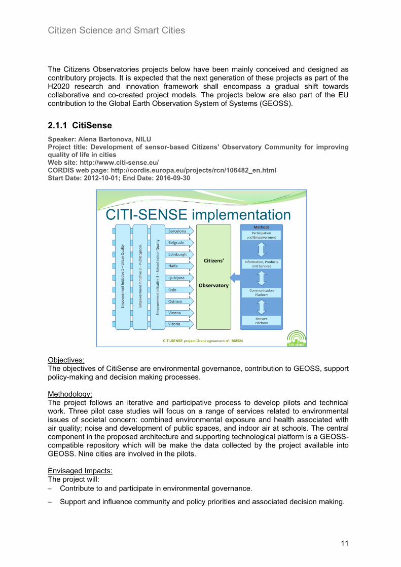
2.1.1 CitiSense
Speaker: Alena Bartonova, NILU Project title: Development of sensor-based Citizens' Observatory Community for improving quality of life in cities Web site: http://www.citi-sense.eu/ CORDIS web page: http://cordis.europa.eu/projects/rcn/106482_en.html Start Date: 2012-10-01; End Date: 2016-09-30
Objectives: The objectives of CitiSense are environmental governance, contribution to GEOSS, support policy-making and decision making processes. Methodology: The project follows an iterative and participative process to develop pilots and technical work. Three pilot case studies will focus on a range of services related to environmental issues of societal concern: combined environmental exposure and health associated with air quality; noise and development of public spaces, and indoor air at schools. The central component in the proposed architecture and supporting technological platform is a GEOSS-compatible repository which will be make the data collected by the project available into GEOSS. Nine cities are involved in the pilots. Envisaged Impacts: The project will:
Contribute to and participate in environmental governance.
Support and influence community and policy priorities and associated decision making.

Citizen Science and Smart Cities
12
Contribute to Global Earth Observation System of Systems (GEOSS).
Key issue learned: Good results in engaging students and teachers in schools in the air quality indoor pilot. This indicates the success of a Citizen Science project strongly depends on finding the right (motivated) community.
2.1.2 Omniscientis
Speaker: Bernard Stevenot, Spacebel Project title: Odour MoNitoring and Information System based on CItizEN and Technology Innovative Sensors Web site: http://www.omniscientis.eu/ CORDIS web page: http://cordis.europa.eu/projects/rcn/105522_en.html Start Date: 2012-10-01; End Date: 2014-09-30
Objectives: Odour is recognized as the second source of complaints to Public Administrations. In addition, odour regulations are complex and not homogeneous across Europe. The aim of the project is to change the role of citizens from victims to active contributors to address/mitigate the issue. Methodology: The project seeks to bring relevant stakeholders (e.g., experts, mediators, citizens) together through a Living Lab approach. The project will develop a web-based platform for odour monitoring based on geo-mobile applications (e.g. OdoMAP, OdoMJS,), along with in-situ sensors (e-noises services) interfaced by the Sensor Observation Services (SOS) and Sensor Alert Services (SAS) service specifications. Specific dispersion models would be an integral element of the web-based platform to enhance odour monitoring. Technically, the web–based platforms will rely heavily on web standards (e.g. HTML5, CSS3), open source JavaScript libraries (e.g. AngularJS, OpenLayers, D3js) for developing front-end applications, and OGC standards service specifications (e.g. WPS, SPS, WFS, WMS). Two pilot case studies –Pulp & Paper Mill in Belgium, and Pig Farm in Austria – will assess the services and tools that are being developed within the project.
Citizen Science and Smart Cities
13
Envisaged Impacts: The project will:
Contribute to and participate in environmental and odour governance.
Use of widely-accepted web standards and OGC services.
Integrate collected data from citizens (VGI) and in-situ sensors with odour dispersion models.
Contribute to Global Earth Observation System of Systems (GEOSS). Key issue learned: Viable ways to sustain the expected results of the project (web-based platforms, models, services, apps, etc.) are being discussed. From the social perspective, keeping citizen community active and motivated even after the end of the project is a key concern. From the financial point of view, finding sustainable business models in the long term to compensate operational costs after the project ends is a must. In this regard, selling solution to interested stakeholders such as local authorities and industry is an option being considered
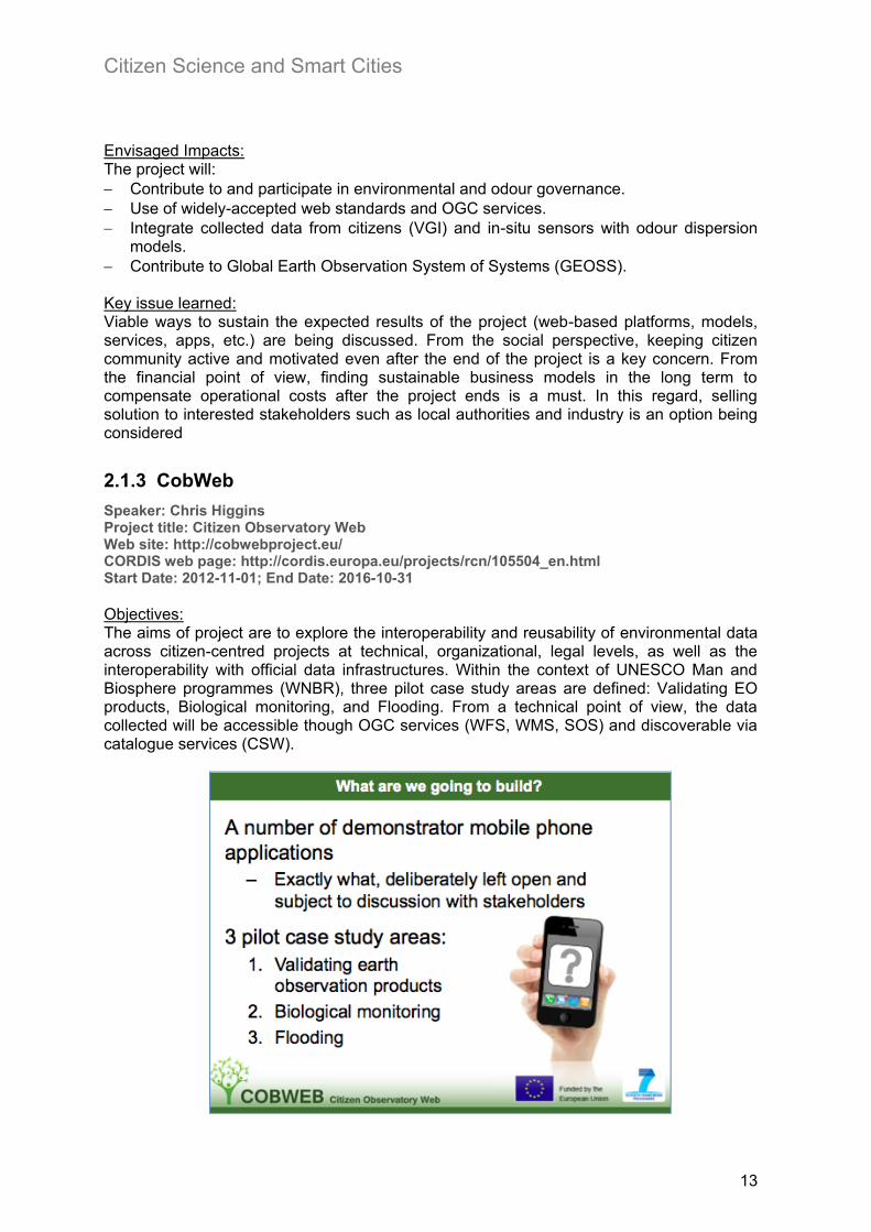
2.1.3 CobWeb
Speaker: Chris Higgins Project title: Citizen Observatory Web Web site: http://cobwebproject.eu/ CORDIS web page: http://cordis.europa.eu/projects/rcn/105504_en.html Start Date: 2012-11-01; End Date: 2016-10-31
Objectives: The aims of project are to explore the interoperability and reusability of environmental data across citizen-centred projects at technical, organizational, legal levels, as well as the interoperability with official data infrastructures. Within the context of UNESCO Man and Biosphere programmes (WNBR), three pilot case study areas are defined: Validating EO products, Biological monitoring, and Flooding. From a technical point of view, the data collected will be accessible though OGC services (WFS, WMS, SOS) and discoverable via catalogue services (CSW).

Citizen Science and Smart Cities
14
Methodology: The plan is to participate in GEOSS Architectural Interoperability Pilots (AIP) and look at technology that could be reused in the project. Envisaged Impacts: The project will:
Gather crowdsourced environmental data to aid decision making.
Introduce quality measures and reduce uncertainty.
Combine crowdsourced data with existing sources of data.
Contribute to Global Earth Observation System of Systems (GEOSS). Key issue learned: Even though Cobweb is about environmental data (not personal data), privacy and security remain open issues.
2.1.4 WeSenseIt
Speaker: Fabio Ciravegna Project title: WeSenseIT: Citizen Observatory of Water Web site: http://wesenseit.eu/ CORDIS web page: http://cordis.europa.eu/projects/rcn/106532_en.html Start Date: 2012-10-01; End Date: 2016-09-30
Objectives: The project develops a citizen-based observatory of water, which will allow citizens and communities to become active stakeholders in information capturing, evaluation and communication. An interdisciplinary concept is developed on the basis of three different aspects of community participation in water governance: (i) environmental non-structured data collection via optimized networks of sensors as well as information provided directly by citizens (measurements, images, messages) and via mining of social media portals; (ii) development of descriptive and predictive models (both physical/natural and social) and decision-making tools that will be able to optimally assimilate both social and physical data; (iii) two-way feedback and exchange of environmental knowledge/experience between citizens and authorities for decision-making, planning and governance. Methodology: The project will create and deploy a method, an environment, and an infrastructure supporting an information ecosystem for communities and citizens, emergency operators and policymakers for discussion, monitoring and intervention on water bodies and services. The project bases data capture on: (i) innovative sensor devices which can be used directly by the citizens and (ii) exploitation of the citizens’ collective intelligence through monitoring social networks communications (e.g. Twitter, Facebook, etc.) and allowing citizens and communities to upload data to the observatory.

Citizen Science and Smart Cities
15
Envisaged Impacts: The project will:
Take on a new role in the information chain of water related decisions.
Constantly monitor water resources to make sense of and react to sudden changes and/or emergencies.
Turn citizens and communities into active stakeholders in information capturing, evaluation and communication of such decisions.
Contribute to Global Earth Observation System of Systems (GEOSS). Key issues learned: The project has had excellent result so far with involvement in events with hundreds of thousands of participants. The project has developed an infrastructure that can be deployed during emergencies and planned events. The key concern is one about the sustainability of citizens’ projects: how to increase the number of participants in the project and retain them in the long term.
2.2 Citizen Science, crowdsourcing, and VGI projects
This Section summarises projects from multiple backgrounds. The first two (ENERGIC and Mapping and the Citizens Sensors) are based on two research networks under the European Cooperation in Science and Technology (COST) programme. COST does not fund research activities directly but contributes to scientific innovation by supporting the networking of researchers and institutions (see http://www.cost.eu/about_cost/mission). EmoMap and Everyware are two research projects funded by the Austrian national government and the European Commission DG CONNECT respectively, which were completed in 2013 with some very interesting results. The European Citizen science Association (ECSA) is an important initiative launched in 2013-14 to organise the community of citizen science projects and stakeholders. ECSA builds on the experience of the Open Air Laboratory (OPAL), which is also described in this section, and which provided the first secretariat to ECSA, before this was moved to the Natural Museum in Berlin.
Citizen Science and Smart Cities
16
2.2.1 ENERGIC
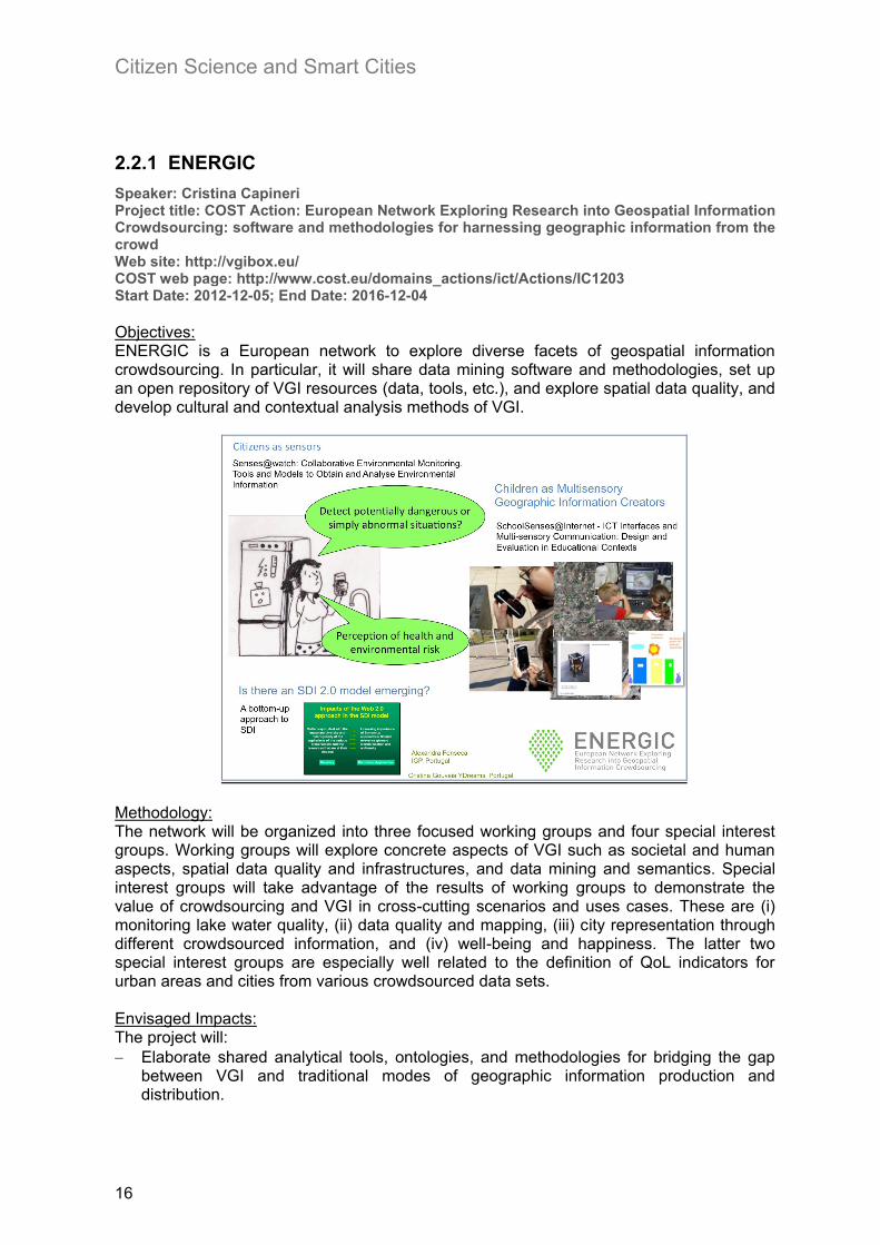
Speaker: Cristina Capineri Project title: COST Action: European Network Exploring Research into Geospatial Information Crowdsourcing: software and methodologies for harnessing geographic information from the crowd Web site: http://vgibox.eu/ COST web page: http://www.cost.eu/domains_actions/ict/Actions/IC1203 Start Date: 2012-12-05; End Date: 2016-12-04
Objectives: ENERGIC is a European network to explore diverse facets of geospatial information crowdsourcing. In particular, it will share data mining software and methodologies, set up an open repository of VGI resources (data, tools, etc.), and explore spatial data quality, and develop cultural and contextual analysis methods of VGI.
Methodology: The network will be organized into three focused working groups and four special interest groups. Working groups will explore concrete aspects of VGI such as societal and human aspects, spatial data quality and infrastructures, and data mining and semantics. Special interest groups will take advantage of the results of working groups to demonstrate the value of crowdsourcing and VGI in cross-cutting scenarios and uses cases. These are (i) monitoring lake water quality, (ii) data quality and mapping, (iii) city representation through different crowdsourced information, and (iv) well-being and happiness. The latter two special interest groups are especially well related to the definition of QoL indicators for urban areas and cities from various crowdsourced data sets. Envisaged Impacts: The project will:
Elaborate shared analytical tools, ontologies, and methodologies for bridging the gap between VGI and traditional modes of geographic information production and distribution.

Citizen Science and Smart Cities
17
Stimulate collaborative and multidisciplinary approach across distinct disciplines (geocomputation, geography, sociology, etc.).
Key issues learned: The project is just over 1 year into its 4 years activities. It has a very large reach with 23 countries involved, is very well connected to other citizen science projects, and is thematically close the core interests of the JRC UrbanQool project. It offers therefore many opportunities for collaboration that will be exploited in the coming months.
2.2.2 Mapping and the Citizen Sensors
Speaker: Jeremy Morley Project title: COST Action: Mapping and the Citizen Sensors Web site: http://www.nottingham.ac.uk/td1202/index.aspx COST web page: http://www.cost.eu/domains_actions/ict/Actions/TD1202 Start Date: 2012-11-28; End Date: 2016-11-27
Objectives: The aim of the COST action is to enhance the role of citizen sensing in “mapping”. In this sense, the project reduces the scope of VGI to producing “community maps” Methodology: The project is divided in four working groups to build the foundations and define current status of citizen sensing in mapping, while growing and being outward looking. The working groups are: (i) Review current sources of VGI and VGI properties (quality), (ii) Identify ways to engage with volunteer community, (iii) Identify data needs and desires (especially of NMAs), and (iv) Identify data needs and desires. The two first groups are especially relevant as they try to characterize VGI sources in function of their quality of service, and formulate strategies to better engage with community. Envisaged Impacts: The project will:
Enhance the role of citizen sensing in mapping.
Identify benefits from individual to organisations as well as research community. Key issues learned: The project put a strong emphasis on engagement, and the creation of several dissemination activities to target diverse audience, especially in Africa. In this respect, a community mapping effort is underway through a platform called “taarifa” (http://taarifa.org/)
for information collection, visualization and interactive mapping was developed.

Citizen Science and Smart Cities
18
2.2.3 EmoMAP
Speaker: Haosheng Huang, Vienna University Project title: Emotional Maps Web site: http://openemotionmap.org/
Objectives: The aim of the project is to collect people’s affective responses towards environment and their level of comfort. In short, exploring how people perceive their surrounding environment.

Citizen Science and Smart Cities
19
Methodology: Two cases studies were proposed to explore the impact of environmental characteristics based on people’s affective responses and to enable smart human-centred geospatial applications. The speaker made the case to differentiate objective layers from subjective layers. Envisaged Impacts: The project aims to enhance one’s perception and understanding of the surrounding environment. Key issues learned: The project combines subjective layers on top of objective data. It raised important questions in the definition, interpretation and analysis of subjective data which have direct implications in the context of subjective Quality of Life indicator in cities. Subjective and objective data are considered “layers” from a geospatial perspective. However, the nature of objective and subjective data varies greatly. The latter is extremely time and context-dependent in that one’s opinion about the same topic may vary along the day (morning, afternoon, evening), location (home, work, driving, etc.), and cultural context.
2.2.4 EveryAware
Speaker: Vito Servedio Project title: Enhance environmental awareness through social information technologies Web site: http://www.everyaware.eu/ CORDIS web page: http://cordis.europa.eu/projects/rcn/98164_en.html Start Date: 2011-03-01; End Date: 2014-02-28
Objectives: The rational of the project is described as a closed cycle: objective and subjective monitoring leads to enhance awareness, which may change individual behaviour, and in the end it makes pressure on policy making.

Citizen Science and Smart Cities
20
Methodology: It takes a citizen-science approach to raising citizens’ awareness on urban sound pollution and air quality. Specific applications built including a sensor box (Arduino + low-cost sensors) and Wide noise apps (widenoise.eu). Key challenge: encouraging and retaining citizen engagement. For example, the AirProbe Challenge 5 used gamification and competition as strategy to engage teams of citizens. Envisaged Impacts: Raising citizens awareness on urban sound pollution and air quality, and make pressure on policy making by stimulating change of individual behaviours. Key issues learned: Subjective data is defined in this project as objective data (e.g. sensor measurements) attached with subjective information such as tags, annotation, votes and comments.
2.2.5 Open Air Laboratories (OPAL)
Speaker: Laura Gosling Web site: http://www.opalexplorenature.org/
Objectives: The objectives of OPAL are to get more people outdoors, educate and inspire them about the natural world, gain a greater understanding of our environment and forge strong collaboration between the community, voluntary and statutory sectors. OPAL focuses on public engagement in nature, particularly targeting schools and participants from disadvantaged backgrounds.
Methodology: The project uses a series of simple but effective steps to engage people in data collection. First, field surveys accompanied with guided and visual forms, and field notebooks. Regardless of the methods or techniques used (digital devices, paper forms, etc.), providing
5 http://www.everyaware.eu/category/apic/

Citizen Science and Smart Cities
21
clear, simple and complete instructions to carry out a task is a recipe for success in any citizen science project. People need to fully and clearly understand what to do in simple words. Second, running regular survey days and training events directly with people as well as giving regular talks, workshops and conferences are vital too. Education is again essential to engage, inspire and get feedback from the community. The project has defined three simple steps to turn raw data into processed data: (i) data cleaned by scientists, (ii) preliminary results published at web site, (iii) Journal articles (http://www3.imperial.ac.uk/opal/publications). Envisaged Impacts: Foster and stimulate public engagement in nature to diverse audience Key issues learned:
A set of concrete, simple, and logical steps is important to engage people.
Education is vital. Taking care of the clearness and completeness of the materials delivered to citizens is equally important too.
Great examples of communicating science to the public6.
2.2.6 European Citizen Science Association
Speaker: Katrin Vohland
Web site: http://ecsa.biodiv.naturkundemuseum-berlin.de/ Objectives: The goals of ECSA are to develop a European citizenships and public engagement with science, while capturing the European “touch” to citizen science.
Methodology: ECSA has just been launched and the list of members does not yet cover all the geographic areas across Europe. Most members come from environmental and natural sciences (e.g.
6 “OPAL Community Environment Report”, http://www.opalexplorenature.org/CEreport

Citizen Science and Smart Cities
22
museums). Through working groups, ECSA is going to cover a wide range of aspects of Citizen Science. The 1st general assembly was held on April 8th, 2014 Envisaged Impacts: Apart from the general goal mentioned above, more specific objectives are developing EU wide citizen science programmes, to identify best practices in citizen science, and develop a common European approach to citizen science, in terms of methodologies, education, and training materials.
2.3 Smart Cities related projects
2.3.1 EPIC
Speaker: Shenja van der Graaf Project title: EPIC: European Platform for Intelligent Cities Web site: http://www.epic-cities.eu/ ICT-PSP (Policy Support Programme) web page: http://ec.europa.eu/information_society/apps/projects/factsheet/index.cfm?project_ref=270895 Start Date: 2010-11-01; End Date: 2013-04-30
Objectives: The EPIC project was designed to combine state-of-the-art cloud computing technologies with fully researched and tested e-Government service applications to create the first truly scalable and flexible pan-European platform for innovative, user-driven public service delivery.
Methodology: EPIC provides an extensible cloud-based solution for cities, a sort of “plug & play” solution for smart cities 7 . The outcomes are fundamentally a set of components and services already available and reusable. The set of components were developed in the context of
7 See related blog post at https://ec.europa.eu/digital-agenda/en/blog/epic-enabling-every-city-europe-access-
and-deploy-innovative-smart-city-applications

Citizen Science and Smart Cities
23
three pilots: Smart environmental pilot (domestic energy, energy consumption), urban planning pilot, and relocation pilot (expat mobility). As a proof of concept, the project combined different components from the three pilots in a new integrated scenario, to demonstrate how reusable the components and services are. The project followed a Living Lab approach, which expressly engages citizens in service design. It began with a closed group to increasingly move to an open group of stakeholders (citizens, SMSs, government, etc.) for evaluation purposes. Key issues learned: The results achieved by the EPIC project demonstrated how commercial and private party information can be used in an integrated semantic platform, in which no user data is permanently held. Ease of use and intuitive design are critical for uptake of applications. With respect to content, Point of Interest, community indicators are crucial. The project advocates the need for cloud-based platforms that incorporate feedback mechanisms.
2.3.2 Helsinki
Speaker: Jarmo Elukka Eskelinen Project title: Forum Virium Helsinki: Building an Open City through PPPP: public – private – people partnerships Web site: http://www.citysdk.eu/
The experience of Helsinki shows that building an open city requires establishing closely-knit partnership among public, private sectors, and citizens. Jarmo predicted that mainstream commercial smart-cities infrastructures will fail to adapt to the urban dynamics which are highly unpredictable living organisms. A promising approach is to rely on the problem-solving competence of urban communities (city-citizens-developers), and to establish dynamic feedback mechanisms. Such a retrofit approach complements existing top-down approaches of commercial companies for Open Data. Therefore, tapping in the urban fabric and working with the city (not just for the city) is an enabler for smartness and promises to expand the city markets. In such a setting, interoperability, trustworthiness, feedback mechanisms and engagement techniques are critical factors, which deserve more investigation.

Citizen Science and Smart Cities
24
The City Service Development Kit addresses interoperability issues. It has been used to develop various Smart initiatives across European cities8 such as Smart tourisms in Lisbon, and Smart city in Amsterdam. It is also worth looking at project Open311 API 9 that centralizes 50 interoperable APIs around the globe. Envisaged Impacts:
“City is an enabler” to incubate & evaluate, invest & define, motivate & educate.
“Citizens are the ears and the eyes of the city.” Key issues learned:
Find the right “change agents”, people (not technology) who really intend to lead the change in cities.
“There is no one-size-fits-all solution”.
From smart city to smart/integrated territorial strategy, i.e. network of interrelated smart cities in a given area/territory is the way forward. Bing implemented in Finland.
2.3.3 Trentino
Speaker: Lorenzino Vaccari Project title: The case of Trentino Web site: http://dati.trentino.it/
Objectives: Open Data use case for the province of Trentino. Innovation is a key policy driver in the autonomous province of Trentino. The goal is to move towards a common smart city and smart territory platform that brings communities, open services, Big Data and Linked Data together.
Methodology:
8 See related blog post at https://ec.europa.eu/digital-agenda/en/blog/citysdk-helping-cities-open-their-data-and-giving-developers-tools-they-need 9 http://open311.org/

Citizen Science and Smart Cities
25
“School of data” is a methodology developed by the Open Knowledge Foundation and successfully adopted in Trentino to raise awareness, train staff, journalists, researchers, and student to handle data, and use them in innovative ways. Education is an essential factor to engage and keep citizens motivated in smart cities/citizen science projects. Envisaged Impacts: A shift from Smart City to Smart Territory (connected urban centres), similar to the Helsinki case. Key issues learned:
Open data portal, along with semantics and linked data technologies, is in place.
School of Data (education) to engage. It is closely connected to the vision of OPAL and ECSA.
2.3.4 Dublin
Speaker: Melanie Bouroche Project title: Future Cities: Trinity Smart and Sustainable Cities Research Centre Web site: http://www.tcd.ie/futurecities/
Objectives: The Trinity’s Future Cities is a recently created research centre focused on Smart and Sustainable Cities. Its goal is to co-design the future of cities by combining technology, regulation, lifestyle, sustainability, urban planning and business models. GreenWatch is a good example of project harnessing the power of the crowd to encourage more sustainable and efficient urban living. Methodology: The project adopted a multi-disciplinary approach to address managing limited resources –co-design with the community central paradigm. The project collaborates with Intel to develop middleware that can integrate multiple sensors, mobile apps, and human inputs. Data is published as Open Data.
Envisaged Impacts:

Citizen Science and Smart Cities
26
Bridging the gap between theory and practice on sustainability. Contribute through citizen participation in a more sustainable urban living. Key issues learned:
People really care and are happy to get engaged. Nevertheless, citizen engagement over time generally follows a power law distribution (long tail), i.e. after an initial high peak in participation the number of participants progressively decreases over time. The challenge that Citizen Science projects are facing today is how to avoid the long tail effect or at least to minimize it. In other words, what are the motivating factors that would allow to sustain participation in the long run.
2.3.5 The Geothink.ca
Speaker: Stephane Roche Project title: The Geothink.ca: Canadian Geospatial and Open Data Think Tank Web site: http://geothink.ca/category/geothink-project/ Start Date: 2013; End Date: 2018
Objectives: This is a 5-year project on geospatial technology and social sciences research. The main objectives are to study: (i) the interplay of citizens & local government on bi-directional exchange of location information; (ii) and the way in which (geo) technology shapes, and is shaped by, this exchange.
Methodology: The project will focus on the intersection between Governance, Citizenship, and Technology and study in particular issues of ubiquitous on-line access and impact on the city, spatial authenticity and accuracy, locational privacy and Intellectual property. The project will also study the impact of Open Data on governance, explore the relationship between space, place and social justice, and analyse the geoweb political economy.

Citizen Science and Smart Cities
27
Envisaged Impacts: The key expected impact is a greater understanding of, and knowledge about, key phenomena in modern on-line life.
2.3.6 City Blueprints
Speaker: Bernd Gawlik on behalf of Kees van Leeuwan Project title: Sharing best practices on Urban Water Cycle Services & Improving Implementation Capacities of Cities and Regions Web site: http://www.eip-water.eu/working-groups/city-blueprints-improving-implementation-capacities-cities-and-regions
Objectives: The goal is to define a baseline assessment for the sustainability of urban water cycle services (UWCS) in cities. Methodology: 24 indicators have been defined which cover a wide spectrum of water-related factors such as security, quality, sanitation, drinking water, and so on. These indicators are fed with public data and water utilities data when possible. As a result, a Blue City Index (BCI) was calculated for 25 cities as the arithmetic mean of the 24 indicators. Testing results for eleven cities show a positive correlation between BCI and other indices such as the Voluntary participation index (r=0.727), Government effectiveness (r=0.927), GDP (r=0.927) and high UWCS commitment (r=0.904). Not surprisingly, cities that are more environmentally conscious are also better managed, more innovative, and therefore show positive results also on the side of public engagement, and satisfaction (Van Leeuwen, 2013).
Envisaged Impacts: The project has become an enabler to share best practices across cities and help making substantial progress on water sustainability. Key issues learned:

Citizen Science and Smart Cities
28
It was difficult to find local information on surface water quality, groundwater quality, biodiversity and voluntary participation.
The project would like to include local information plus also information on knowledge and perception of the citizens on water, waste-water, appreciation of living in their city.
Sharing best practices among cities by involving citizens much more intensively is crucial.
2.3.7 The Ecological Sequestration Trust (TEST)
Speaker: Peter Head, The Ecological Sequestration Trust Project title: Smart Citizens & Resilient Regional Development ‘high quality growth’ Web site: http://ecosequestrust.org/,
Objectives: The key objective of the initiative is to identify the policies, investments, and strategies in low, middle, and high-income countries to achieve a sustainable way of living. Methodology: The initiative is based on a comprehensive resource model of sustainable development. The model integrates economic, environmental and social dimensions, with a similar approach as that of Griggs et al. (2013) who also developed a unified approach across the three dimensions, so that safeguarding the Earth and environmental systems becomes an equally important variable to economy and society in the Sustainability equation.
TEST is proposing to run a set of pilots in different parts of the world (Europe, the Americas, China, and Africa). The TEST high-level approach/methodology combines service network, resource flow, agent activities and land use to create a kind of Open-Source, Agent-based Urban-Rural Resource and Economics Systems Platform Model. Envisaged Impacts:

Citizen Science and Smart Cities
29
The next step is to move forward “regional collaborative intelligence”, similar to the concept of Smart Territory highlighted in the Trentino and Helsinki cases. The JRC agreed to support a TEST project in Dorset through its expertise in data common frameworks, standards, and data repository, and help shift citizen science and smart cities projects from an observatory to a collaboratory approach.
2.3.8 ESPON CityBench
Speaker: Joaquin Huerta Project title: ESPON CityBench: European Urban Benchmarking Web Tool Web site: http://espon.geodan.nl/citybench2/ ESPON http://www.espon.eu/main/Menu_Projects/Menu_ScientificPlatform/citybench.html Start Date: 12/2012; End Date: 02/2014
Objectives: The project aims to compare regions across multiple dimensions and implement suitable visualization tools. Methodology: Two use cases are proposed. The first one is a preliminary study to set up a Science park in Amsterdam and Rotterdam. The second use case lets users seek and compare one’s own city with others to find similar cities according to indicators. On the server side, the Citybench social media tool, which collects data from heterogeneous Web 2.0 sources take advantage of big data and map reduce technologies, to make multi-dimensional data comparisons. On the client side, a web-based tool allows user to explore city similarities either using a map-view interface or radial-view interface.
Envisaged Impacts: Cities in Europe face similar issues, so the comparison through interactive tools that take advantage of both traditional and Web 2.0 sources can facilitate exchange of experience and synergy.

Citizen Science and Smart Cities
30
Key issues learned:
The list of proposed city indicators may serve as a basis to define UrbanQooL indicators.
Interactive visualisation is important to keep user attracted.
2.3.9 Cities Geo-Wiki
Speaker: Linda See Web site: http://cities.geo-wiki.org/
Objectives: Geo-Wiki is a visualization, crowdsourcing and validation tool for land cover data. Two approaches to engage people as validators: (i) crowdsourcing competition and (ii) Cropland Capture game to explore the idea of human computation games to solve problems (i.e. land use validation) that computers cannot solve or need huge amounts of computational resources and so makes the problem unaffordable. Methodology: The experience of Geo-Wiki can be applied to cities in the context of WUDAPT (World Urban Database & Access Portal Tools). The overall idea is to map the physical geography of all major cities in the world including urban canopy parameters and morphological material database at kilometre or sub kilometre scale to link to weather and climate models (local climate zones).
Envisaged Impacts:
Geo-wiki is a successful example of participative approach to address land-use related issues.
Geo-wiki team has been recently awarded with a 5-year grant by the European Research Council, which will allow them to expand and enhance current geo-wiki capability.
Key issues learned:

Citizen Science and Smart Cities
31
Strong effort and experience on community engagement through gamification and competition.
2.4 Other relevant projects
2.4.1 Services for Smart Cities and Quality of Life
Speaker: Giovanna Di Marzo (University Geneva) Project title: Self aware Pervasive Service Ecosystems Web site: http://www.sapere-project.eu/ CORDIS web page: http://cordis.europa.eu/projects/rcn/94731_en.html Start Date: 2010-10-01; End Date: 2013-09-30
Objectives: The project developed context-aware smart services that capture sensed data. For example in urban spaces (traffic steering) and crowd events like marathons by collecting data from diverse “entities” (runners, spectators, etc.). Methodology: There are different methodologies for the different projects developed. The basic idea is to combine different datasets and develop a MyQoLService. Developments relate to self-composition of services, based on decentralized, Self, and bio-inspired techniques.
Envisaged Impacts: Potentially significant impacts supporting personal life style, and city managers operations. Key issues learned: The examples shown range from approaches to steering crowds and traffic, to different methods for data analysis and propagation, to living labs approaches to collect mobility data.

Citizen Science and Smart Cities
32
2.4.2 EnviroCar & SenseBox
Speaker: Thomas Bartoschek (Uni Muenster) Web site: https://www.envirocar.org/ Web site: http://www.sensebox.de, http://52north.org/communities/sensorweb/incubation/sensebox/index.html
Objectives: EnviroCar: The project turns a car into a mobile sensing platform. It aims to raise collect environmental data and raise awareness towards more conscious driving style. SenseBox: Educational citizen science project for schools to teach about science and measure environmental phenomena and publish Open Data. Methodology: EnviroCar provides an interface between the sensors on board modern cars and web portal via mobile devices. The applications are for example the identification and analysis of CO2 hot spots and analyses of GPS tracks. The SenseBox project is used to teach science in general and GIS in particular in schools. This project is a great example on how to communicate science to students and how the kit can be successfully used to ask challenging questions to students in order to stimulate them in the scientific/spatial thinking. A web portal10 complements the SenseBox kit, which comes with additional documents, tutorials, code snippets on transferring data, and exercises for kids to program balloon mapping and so on.
Envisaged Impacts: An important expected impact is the development of an OpenSenseMap, based on the same technology as OpenStreetMap, but delivering sensor information. A new layer in traditional GIS mapping that could become a standard feature in many types of analyses. Key issues learned:
The EnviroCar project shows how to leverage vast amount of sensor information already collected routinely by cars, and make available for reuse via a simple interface.
10 http://opensensemap.org/

Citizen Science and Smart Cities
33
The SenseBox as a great example of a project supporting learning about science and the scientific process. In this case the accuracy of the data collected is not that important. The process is the outcomes.
2.4.3 Policrowd
Speaker: Maria Brovelli (POLIMI) Project title: Policrowd, A social World Wind Platform Web site: http://geomobile.como.polimi.it/policrowd/
Objectives: Policrowd was developed as an application of NASA World Wind to promote tourism and cultural heritage. Methodology: Users upload and characterize points of Interest at different Levels of Details through an app. That guides the users thorough the different steps, from taking a photograph to classifying, commenting, and uploading. Envisaged Impacts: Policrowd is an educational tool but at the same time allows the crowd sourcing of Points of interest which can be part of territorial marketing.
2.4.4 DeforestAction EarthWatchers
Speaker: Henk Scholten (Geodan) Project title: DeforestAction: EarthWatchers Web site: http://www.geodan.com/research/projects/borneo/earthwatchers/
Objectives: Empowering world citizens in tropical forest monitoring via the integration of Earth Observation, social media, human computation and collaborative intelligence. Methodology:

Citizen Science and Smart Cities
34
Create local teams in developing countries of young people and provide them with new skills in relation to Earth Observation data, and radar (SAR) data to identify area most likely at risk of deforestation and where ground checks are needed.
Envisaged Impacts:
Support to local environment and reduced deforestation.
Learning of new skills in relation to geographic data.
Learning of programming skills. Key issues learned: Education is critical to engage, and put the required means in the hands of people so that they can help themselves.
2.4.5 Citizen science: Evidence based versus emotion
Speaker: Martin Peersmann
Objectives: Develop a framework to inform public debate around contentious issues like fracking and energy supply. Methodology: Combine data from different sources, but guide the learning process from data to analysis and evidence. Envisaged Impacts: Very important topic as re-building trust between the public, government and science is crucial. Key issues learned: Opening up the data is one step but not enough. In fact high-tech approaches can be counter-productive if they are applied in an environment where the basic elements of trust

Citizen Science and Smart Cities
35
are not present. Important to first build bridges through dedicated campaigns using multiple media.
2.4.6 GeoSmartCity
Speaker: Giorgio Saio Project title: GeoSmartCity: open geo-data for innovation services and user application towards Smart Cities Web site: www.geosmartcity.eu
Objectives: The project aims to support cities to ‘open’ their data, and to facilitate the provision of tools to integrate GI data with Open Data for both professional users and the general public.

Citizen Science and Smart Cities
36
Methodology: The project defines two application scenarios: Green energy (5 pilots) and underground (6 pilots), which essentially refer to the problems of having different infrastructures under the same area which make it difficult the management of utilities, safety and security, and planning processes. Envisaged Impacts: An open infrastructure aims to support new business models for both public administrations and SMEs. Key issues learned: Strong focus on standards and data harmonization in the context of INSPIRE by the application of the linked Open Data protocol on geospatial information.
2.4.7 GeoKnow
Speaker: Jens Lehmann Project title: GeoKnow: Making the Web an Exploratory Place for Geospatial Knowledge Web site: http://geoknow.eu/ CORDIS web page: http://cordis.europa.eu/projects/rcn/106337_en.html Start Date: 2012-12-01; End Date: 2015-11-30
Objectives: Enhance the Web as a global distributed platform for data information and knowledge integration by combining GIS and semantic technologies. Methodology: The project develops the so-called Linked Data Stack11, which is a set of reusable tools supporting all life-cycle phases of Linked Data.
11 http://stack.linkeddata.org/

Citizen Science and Smart Cities
37
Envisaged Impacts: The project transforms major datasets such as OpenStreetMap and INSPIRE into Linked Data. The tools created or improved in the project will be applicable to several use case, in particular e-commerce, Supply Chain Management and CRM are already tested and applications in smart cities are possible. There is a strong use of standards like GeoSPARQL in the project. The project aims to develop a reusable platform for Linked Data projects. Key issues learned:
Creating a reusable platform it is possible to develop projects quickly using the Linked Data Paradigm. Some applications of the project are already being taken up e.g. Continental database of Point of Interest near major highways through crowd sourcing.
The Linked Data Stack will be developed throughout several EU projects (currently LOD2 and GeoKnow) and is fully compatible with Linux server installations. This avoids the need to reinvent platforms for similar projects in this area.
2.4.8 SmartOpenData
Speaker: Karel Charvat Project title: SmartOpenData: Linked Open Data for environment protection in Smart Regions Web site: http://www.smartopendata.eu/ Start Date: 2013-12-01; End Date: 2015-11-30
Objectives: The objectives of the project are to harmonize and integrate (i) environmental research and VGI data, (ii) environmental data initiatives like INSPIRE and related projects, and (iii) Open Linked data for storing results of analyses and processes as Open Data.
Methodology: Moving from Discovery metadata (INSPIRE) to Fusion metadata (SmartOpenData). Use of Linked Data principles for data integration. Test the approach through pilots on agroforestry, biodiversity and water monitoring among others. Envisaged Impacts:

Citizen Science and Smart Cities
38
Sustainable Linked Open Data infrastructure to promote environmental protection data sharing among public bodies in the European Union
Integration of semantic technologies and approaches
Definition of business model targeted to SMEs. Key issues learned: The project builds on a range of past projects and can use this past experience for testing the architecture and data integration.
2.4.9 UJI Smart Campus
Speaker: Joaquin Huerta Web site: http://smart.uji.es/
Objectives: Smart campus is a platform for university service management developed as a “smart city testbed” to support learning and rapid prototyping of apps. It is also used for teaching about Smart Cities technologies. Methodology: Technologically the platform is a web-based application and a 3d viewer based on ESRI software The Application however demonstrates to administrators and managers a new way to organise the information available.
Envisaged Impacts: Visibility to the project and the department, and a very good tool for teaching, learning, as well as a framework for managing the assets of the University. Key issues learned:
The project has become a platform for collaboration across the University.
May be worth considering for the Ispra site to link management objectives with building expertise and testing technology.

Citizen Science and Smart Cities
39
2.5 Brokering approach
Speaker: Stefano Nativi, Italian National Research Council (CNR) Web site: http://www.eurogeoss.eu/
One of the key objectives of the Summit was to explore how data services and apps coming from citizen science and smart cities initiatives can be made interoperable and reusable. Given the variety of approaches, technologies, and standards, a valuable contribution comes from the Brokering framework, initially developed by CNR as part of an FP7 project coordinated by the JRC (ww.eurogeoss.eu) and then adopted by the Group for Earth Observation to link the many systems, capacities and communities contributing to the Global Earth Observation System of Systems. Stefano Nativi (CNR) presented the brokering middleware the purpose of which is to build a Network of Networks or System of Systems connecting complex and heterogeneous system and networks at different levels. The approach is built upon four main principles: (i) build on existing networks/system infrastructures, (ii) supplement, not supplant them, (iii) lower barriers avoiding to impose ant common federated technology or single standard, and (iv) be flexible and extensible to allow evolution. The key innovation of the Brokering approach is the change in paradigm: rather than building interoperability by requiring the agreement on a single set of standards, which in a complex multidisciplinary environments does not work, the Brokering middleware allows each system to stay as is, and builds bridges, or mediates, between them allowing to search and access data across them all (Nativi et al. 2012, and 2013).
The success of the Brokering to develop GEOSS has been extraordinary. Within a matter of months from its adoption, GEOSS moved from a few thousands datasets to being able to search and access across several million data resources. If the Citizens Science projects are willing to share their data, the GEO DAB could be extended to broker them since most of the technology these projects use is already supported by the brokering infrastructure.

Citizen Science and Smart Cities
40
3 Citizens-contributed data: an engine for better science,
sustainable cities, and transparent governance
The projects summarised in Section 2 show the breadth of activities covered under the citizen science/ citizen-generated content labels. Many projects focus on data collection, raising awareness, contributing to environmental monitoring, others are more educational oriented, but by and large they all combine these different dimensions. Smart cities projects, although not as well represented in the meeting, show also similarities and differences in approaches, technologies, and applications. What is clear is that the synergies between the two sets of initiatives are relatively weak. In this section we summarise the key points emerged from the very extensive discussions held during the meeting.
3.1 The Drivers for Sharing
There are strong scientific and policy drivers for sharing data, applications, and methods and contribute to greater scientific insights, more democratic and participative processes, and a stronger base for innovation and growth. The Digital Agenda is a key flagship to achieve the objectives of the European Union 2020 strategy for smart, sustainable, and inclusive growth12. Open Data strategies in particular are seen as playing a crucial role in supporting innovation and growth, greater transparency in public administrations, and social and political engagement1314. The G8 Open Data Charter adopted at the 2013 Summit (http://www.g8.utoronto.ca/summit/2013lougherne/index.html) indicates the widespread political commitment behind Open Data, which is paralleled by a strong commitment towards opening up research data and findings. Open Access to Scientific Knowledge is one of the key pillars of the Open Data strategy of the European Union15 to foster scientific research and the dissemination of knowledge across the scientific community, but also towards SMEs that do not have the resources to invest directly in research or even to access the innovation potential created by new scientific discoveries. The policy drivers highlighted above complement the increasing recognition in the scientific community that to address the key challenges of the 21st century we need to move beyond the boundaries of disciplinary research and engage in research that is multi-disciplinary and participatory. For example, the International Council for Science (2010) argued that:
Over the next decade the global scientific community must take on the challenge of delivering to society the knowledge and information necessary to assess the risks humanity is facing from global change and to understand how society can effectively mitigate dangerous changes and cope with the change that we cannot manage. We refer to this field as ‘global sustainability research’. Global sustainability research provides a new holistic approach to science, building upon and integrating expertise within the sciences (social, natural, health, and engineering) and humanities. This
12 http://ec.europa.eu/europe2020/index_en.htm
13 http://ec.europa.eu/information_society/policy/psi/docs/pdfs/directive_proposal/2012/open_data.pdf
14 http://data.gov.uk/sites/default/files/Open_data_White_Paper.pdf
15 http://ec.europa.eu/digital-agenda/en/open-access-scientific-knowledge-0

Citizen Science and Smart Cities
41
holistic vision will contribute to provide innovative responses to the pressing coupled social-environmental research questions of human interactions with the Earth system16
To develop global sustainability research ICSU argued that two main shifts are needed in the world of science:
There needs to be a much greater collaboration and integration between the natural and social sciences, health science, engineering and the humanities to address properly the complex inter-relationships between physical and social phenomena.
The increased emphasis on multi-disciplinary research must be coupled by a much greater involvement in the research process of external stakeholders through an open and participatory approach building trust in science, and encouraging all actors to take responsibility for collective action to mitigate and adapt to change.
Similar issues were identified by the science strategy of the Belmont Forum (Belmont Forum 2011) and by UNEP that identifies similar recommendations and envisions a new contract between science and society (UNEP 2012). The opportunities of engaging the public in the scientific process of problem formulation, data collection, analysis, and evaluation have to be seen in this wider context of global sustainability research. It is important to note however, that in the same way as there are different levels of participation, from manipulation and therapy (which are non-participation) to informing, and placating (tokenistic), all the way to partnership and citizen control, (Arnstein 1969) there are multiple degrees of public engagement in citizen science. Haklay (2011) distinguishes between four levels of Citizen science, from citizens as sensors at the lowest level, to Participatory Science and Extreme Collaborative Science (See figure 1).
Figure 1: Levels of Citizen Science
16http://www.icsu-visioning.org/wp-content/uploads/GrandChallenges_Pre-publication.pdf
Citizen Science and Smart Cities
42
Source: http://www.slideshare.net/mukih/participatory-gis-volunteered-geographic-information-and-citizen-
science-gisruk-2011
An increasing level of participation and ownership is clearly important and desirable. It may also introduce considerations about Intellectual Property Rights of the participant that need to be addressed at an early stage of the process to ensure that the outcome of the projects can be published, and re-used in full respect of such rights. This leads to a number of additional reflections on data availability and re-usability that are addressed in the following section.
3.2 To Publish or Not to Publish?
Section 3.1 identify a number of important drivers in favour of publishing public sector and research data, including citizen science data, and applications as open as possible (i.e. without restrictions for reuse either for commercial or non-commercial purposes). It is however clear that not all data can be published openly. In some instances, such as the case of COBWEB (2.1.3) some of the data may be sensitive (e.g. rare or protected species) and should only be published in ways not endangering the species in question, either through aggregation and generalisation, or through the signing of user licenses restricting certain uses of the data. In other cases, as Omniscientis (2.1.2) the data maybe openly available but the applications may be protected with a view to exploiting them commercially after the end of the project. In all cases, as suggested earlier, the rights of the contributors to the project, whether project partners or contributing citizens, need to be respected with clear rules of engagement and informed consent about subsequent re-use. Not all partners of a project may be supportive of the policy to publish citizen-collected data. Many project take place in collaboration with local authorities that recognize the potential of citizen participation and data collecting contributions but are not clear yet how to respond to the inputs provided by the public, and how to integrate them into the well-established information flows, which are often regulated by legal requirements. How can data collected by the public on air quality, water quality or noise, often with equipment of low quality, be reconciled with better quality but more sparse observations from official sources? How to manage the debates between the measured magnitude of a phenomenon and the public perception of the same phenomenon informed by observations maybe of lower quality but amplified by the very large numbers of observers? These are not easy questions to address in this early stage of the Citizen Science phenomena, and it is not surprising that many public authorities have difficulties in finding consistent answers.
3.3 What to Publish
Should a project publish the individual level observations (raw data) or analysed and aggregated data? Recent reports argue that Open Data must be raw, open, and linked17 and that 'raw data is like soil'18, in the sense that it is a foundation upon which wealth is created in society. Publishing raw data also allows future re-analyses increasing transparency and reproducibility, which are pre-requisites for scientific advance.
17 http://www.dime-eu.org/files/active/0/ODOS_report_1.pdf
18 http://www.cjr.org/the_news_frontier/data_is_the_new_soil.php?page=all

Citizen Science and Smart Cities
43
Notwithstanding these positions, some of the projects present at the meeting made the point that raw data contributed by citizens can be easily misused and misinterpreted by third-party data consumers and stakeholders. Indeed positions on the subject were divergent between the participants to the Summit. Whilst some projects like EveryAware (2.2.4) are planning to publish raw data (measurements) as they were collected, others emphasized that data collected by Citizen Observatories should be aggregated before being published, suggesting that quality control or data pre-processing mechanisms are required before publishing data in central and public data repositories. For example, individual data observations should be first checked for relevance and then aggregated prior to be published and shared. The dichotomy between raw and processed data poses unresolved questions that need further discussion. On one hand, trust is not possible without an open and transparent policy to inform all stakeholders regarding the business practice, processes, transformations, and technology involved to turn raw data into processed and aggregated data. On the other hand, huge amounts of published raw data may produce a huge “noise” that has the effect of hiding the really useful information for the broader public. Another important dimension supporting the dissemination of knowledge and the reproducibility of scientific evidence is to publish openly not just data but also the methods, algorithms, models, and scientific outcomes so that the whole chain from data collection through to analysis and output can be retraced, tested, and understood better. Not just Open Data but Open Analyses too. This is a positive strategy towards transparency and building trust among scientists, government, and citizens.
3.4 Where to Publish
The exponential rise in number of citizen science projects (the Scistarter19 site lists for example over 600 on-going projects) raises the question of if and how the data that is collected can be accessed and re-used. Many projects seem to guard their data jealously, but even when they are willing to publish the data it often resides on the project web site which then disappears shortly after the end of the project. This is a common issue in many if not most research projects in general, not just citizen science projects. As an example Pepe et al. (2012) analysed the URL links embedded in Astronomy publications over 15 years, and found that 44% of links were broken 10 years after publications. Only 15-20% of links pointing to curated data archives were broken, while links to project or personal websites decayed at a much faster rate. Considering that astronomy is a very well organised community with a significant number of institutional data archives, the situation is clearly much worse for research projects in other disciplines not so well equipped with underlying infrastructures for data repository, curation, and long term access. This is an issue that need to be addressed in general terms also in the Horizon 2020 programme, as the policy to make open as much research data, models, and scientific output as possible needs to be matched by a strengthened network of accessible data archives throughout Europe. Good progress in this direction has been made with infrastructures like OpenAire20, EUDAT21, and PANGAEA22 but the networks need to expand, and become interoperable.
19 http://scistarter.com/about.html
20 https://www.openaire.eu/
21 http://www.eudat.eu/
22 http://www.pangaea.de/

Citizen Science and Smart Cities
44
The projects represented in the Summit were publishing increasing numbers of datasets, models, and apps from their project website, with some cases like that of the Citizen Observatories, having contractual obligations to make the data available also to the GEOSS. A few projects had arrangements for long term data access, such as the OPAL project and the role of UK’s National Biodiversity Network (NBN) as a data repository to store collected observations. Various organizations23 are contributing to the NBN repository, ensuring that observation data will get the maximum visibility as possible and data will be accessible and maintained beyond the end of each individual project. Aside from a few examples of good practice, the majority of projects did not have plans for long-term data archiving, curation, access, and re-use. This is particularly the case among those funded by the EU research programme. This gap could be addressed by the JRC taking a new role in H2020 as data repository for EU-funded citizen science projects. This proposal drew considerable support from the participants, and will be tested in the coming months.
3.5 How to Publish
Publishing data, models, software, scientific publications, and apps as Open Data in inter-connected Open Archives so that it is possible to search through the whole network of archives is clearly important to ensure visibility and reusability of the projects’ outputs. An equally important aspect is that of the interoperability of contents and, where possible, platforms. The evidence from the Summit suggests that at the present time each smart city or citizen science project is developing its own platform for data collection, sharing, and publication. Smart-city platforms could be re-used, but from an organizational point of view, cites are so complex and diverse in regulations that a single smart city solution seems unlikely to meet the needs of the different communities. On the one hand, there are commercial solutions such as those proposed by IBM and CISCO, and on the other hand CitySDK might provide a technical solution for interfacing with smart city services, but the experiences discussed at the Summit show that additional, customizable and locally developed components are needed to address the specificity of each smart city. This is needed as each smart city project has to “work WITH the city (not just for the city)". Working with the community and locally based SMEs is critical for the success of such projects. Interoperability becomes therefore not just a technical issue but a cultural operation to bind the community together. From the point of view of the citizen science projects, there are positive initiatives by the European Citizen Science Association, and its US counterpart, to provide frameworks to share methodologies and knowledge across citizen science projects. Sharing and reuse of data, models, etc. appear to be less of a priority. For example the (US) Citizen Science Association goals are to:
Establish a global community of practice for citizen science Advance the field of citizen science through innovation and collaboration Promote the value and impact of citizen science Provide access to tools and resources that further best practice Support communication and professional development services Foster diversity and inclusion within the field
23 see https://data.nbn.org.uk/Organisations

Citizen Science and Smart Cities
45
(Source: http://citizenscienceassociation.org/overview/goals/) Similarly, the goals of the European Citizen Science Association are to:
Support the growth of national citizen science communities across the EU; Share knowledge and skills on citizen science; Develop EU wide citizen science programmes; Identify, develop and promote best practice and excellence in citizen science; Collaborate with the growing international citizen science community.
(Source: http://ecsa.biodiv.naturkundemuseum-berlin.de/goals) Open Data therefore does not seem to feature highly in the agendas of either association. This is an area where further dialogue is clearly needed to align better the activities of these associations, and the Open Data policy agenda. In Europe, a major effort is underway to develop interoperability across public sector data and services, for example though the INSPIRE Directive, and European Interoperability Framework24. This aims at increasing the dialogue between citizens and their public administrations, improving governance, transparency, and services. As citizens become increasingly producers of information and not just consumers, it is important that this dialogue is underpinned also by interoperability arrangements between the data published by public administrations and that published by the public either as individuals or as part of organised citizen science initiatives. In some cases the citizens’ data takes the form of measurements or quantitative observations, in others they are more qualitative but no less useful. They provide an opportunity to move beyond the quantitative analysis of physical phenomena to include also the analysis of qualitative perceptions of the same phenomena, and of change as perceived by those who live in the geographical space of analysis. Figure 2 captures this interaction. Fig.2. Utilization of subjective and objective observations in governance/planning within the
smart city paradigm.
24 http://ec.europa.eu/idabc/en/document/2319/5644.html

Citizen Science and Smart Cities
46
The technological solutions to achieve interoperability exist for example through the brokering approach (see Section 2.5). Documentation and agreements on the semantic structure and content of the data collected are however also needed as demonstrated in the case of the INSPIRE infrastructure where much of the work has gone in developing the agreements across thematic communities on the data models necessary to ensure interoperability across data themes. The vision shared by the participants in the meeting includes the possibility to search, find and combine, for any geographical location, data and services from heterogeneous sources (administrative government sources, remote sensing, real time sensor networks, citizen-produced content) including both quantitative measures and qualitative information that provide multiple perspectives on the topic of enquiry. This vision can overlap with the many definitions of Big Data (Ward and Barker, 2013) but may also result from the combination of multiple sources of “small data” (Greensberg, 2013). To achieve this vision, we need infrastructures for data repositories and processing, interoperability arrangements and agreements, and also skills to address new analytical challenges. Comparable solutions still have to be developed for models, software, scientific publications, and apps.
3.6 Data quality and analytical challenges
The topic of Quality of Life and well-being is a very good case in which quantitative, official data (e.g. on air and water quality, safety, range of services) needs to be combined with data coming from the public both as measures and observations and as qualitative expressions of the perceptions of the services available, safety, or mobility. In the past, such data was collected through yearly surveys as the cost of such surveys discouraged to run them more frequently. Now, the opportunities created by cheap sensor networks, mobile phones and tablets need to be exploited to supplement the official data. As indicated in Section 1, the Summit used the label Citizen Science as a short-hand for a wide range of activities: from true citizen science projects in which volunteers collect data or observations based on a scientifically robust methodological framework, all the way to the data mining of posting on social networks. In the case of the former, there are no new challenges with respect to data quality and analysis. Volunteers have been used for more than a century to collect data or make observations, and a whole range of methods have been devised from the provision of training, to the validation of instruments, and the statistical analysis of the results. New challenges emerge instead at the other end of the spectrum when dealing with qualitative assertions from a self-selected group of individuals, moving in space and at different times. Some standard techniques can still be deployed such as counts, frequencies, removal of outliers, cross-referencing from multiple sources, ranking, spatio-temporal clustering and so on (see for example Craglia et al. 2012). Nevertheless the results need to be treated with caution with respect to their statistical robustness because of inherent biases in the data, and often unknown sample ratios (i.e. it is in most cases difficult to know if the perceptions expressed are statistically representative of the population as a whole). New methodological challenges emerge also when considering individual perceptions of physical and social phenomena. Here we move from physical geography and the well-known methods of cartography and spatial analysis to the areas of human cognition, and cultural geography, or in other words, from “space” to “place”. Whilst authors such as Harrison and Dourish (1996) take the view that space is the physical environment in which things are located, and place is the cultural environment in which humans act, others have argued that space is itself socially constructed at the individual level (the cognitive

Citizen Science and Smart Cities
47
perspective), as well as social and political levels, including the role of disciplines such as geography and town planning in framing the production of knowledge through discursive practices (Curry 2002; Foucault 1980). What are the implications of considering space and place as socially constructed? First, the traditional analytical tools and methods for spatial analysis based on neat boundaries encapsulating homogenous spaces may be called into question for analysis of what is strongly characterised by discontinuities, heterogeneity, and conflict. Even the First Law of Geography, that near things are more related than distant ones, needs some revisiting in the era of globalization. As argued by Gupta and Ferguson (1992):
“We need to account sociologically for the fact that the "distance" between the rich in Bombay and the rich in London may be much shorter than that between different classes in "the same" city. Physical location and physical territory, for so long the only grid on which cultural difference could be mapped, need to be replaced by multiple grids that enable us to see that connection and contiguity-more generally the representation of territory vary considerably by factors such as class, gender, race, and sexuality, and are differentially available to those in different locations in the field of power.” (p. 20)
This socially motivated re-conceptualization of space and spatial relations may emphasize hierarchically connected spaces, with holes, shadows, and discontinuities (e.g., geographies of fear), rather than the traditional layer-based view of the world adopted by GIS architectures. As argued by Massey (1991), place has multiple identities; it is not a locality with defined boundaries but an instantiation of social relations and understanding that may span larger scales intersecting at a particular locus (a street, a neighbourhood). Place is continually reproduced through a mix of wider social relations. The traditional analytical tools may therefore need revising to take full advantage of the heterogeneity of data sources and reference frameworks at hand.
3.7 Sustainability
The Summit underlined that each citizen science or smart city project produces a rich set of outcomes (data, software, services and applications). So far, there is no distinct management strategy and tool set available for sustaining the results after the individual funding expires. Archiving the project achievements, i.e. storing the created software, services, applications and data for long-term read access, would be a brute-force approach. More sophisticated solutions would allow for further use and modifications. Consequently, we need to create the framework to allow not only new data entry and possible change of data models, but also the evolution of code, hosting of services and continuous functioning of applications. This is particularly challenging, if tools have already been deployed outside the projects influence, which is likely to be the case. For example, applications on smart phones should continue to provide data and the data sets have to be stored in data base that is available for a long time. Furthermore, co-creating an agreed reference framework for the analysis of citizens-generated content is a critical component of the mix of activities needed to build and retain trust when working with communities. This is very important as all too often projects come, work with a community, raise expectations, and then fade away leaving the community behind with a sense of disillusionment. At the same time it is worth noting that the communities active in such topics as the environment are only sub-groups of the whole. For example, three groups of citizens are more likely to be interested in participatory
Citizen Science and Smart Cities
48
environmental measurements a) activists; b) people with interest on the environment; and c) people directly affected by a problem e.g. pollution. It seems clear that the sum of these groups does not cover the entire population in a city. Clearly identifying the target groups, managing expectations, and working with the group rather than for the group are important elements discussed at the Summit. Specific techniques were also debated including gaming and competitions, engaging the traditional media to raise the profile and co-opt larger communities. How to maintain the momentum built remains nevertheless a challenge for most projects that have a finite funding frame. Aside from the funding, bottom up initiatives like social street (http://www.socialstreet.it/) also depend strongly on the commitment of key individuals be developed and sustained.
4 Conclusions and Next Steps
The Citizen science and Smart Cities Summit was a very useful opportunity to scope out the field of activity of these two sets of initiatives. The evidence presented shows the vitality and diversity of the field but also a number of critical points:
Citizen science projects are more than collecting data: they are about raising awareness, building capacity, and strengthening communities.
Likewise, smart cities are not only about ICT, energy and transport infrastructures: Smart cities are about smart citizens, who participate in their city’s daily governance, are concerned about increasing the quality of life of their fellow-citizens, and about protecting their environment. Technology may facilitate but is no solution per se.
Unfortunately to date there seems to be little synergy between citizen science and smart cities initiatives, and there is little interoperability and reusability of the data, apps, and services developed in each project.
It is difficult to compare the results among citizen science, and smart cities projects or translate from one context to another.
The ephemeral nature of much of the data, which disappear short after the end of the projects, means lack of reproducibility of results and makes longitudinal analysis of time series challenging if not impossible.
There are challenges with respect to the analytical methods needed to integrate quantitative and qualitative data from heterogeneous sources that need further research.
Building and maintaining trust are key points of any citizen science or smart city project. There is a need to work with the community and not just for, or on, the community. It is critical not just to take (data, information, and knowledge) but to give back something that is valued by the community itself.
The development of citizen science associations in Europe and the US, as well as fora for smart cities to share experience, components, and tools are important developments that may address some of the points above. There are also actions through which the European Commission Joint Research Centre can make an important contribution:
Map citizen science and smart cities projects, and generate a semantic network of concepts between the projects to facilitate search of related activities, and community building.
Provide a repository for citizen science and smart cities data (anonymised and aggregated), software, services, and applications so that they are maintained beyond the life of the projects they originate from, and made shareable and reusable.

Citizen Science and Smart Cities
49
Develop regional test beds for the analysis and integration of social and environmental data from heterogeneous sources, with a focus on quality of life and well-being.
Undertake comparative studies, and analyse issues related to scaling up to the European dimension.
Make available the JRC knowledge base on semantic interoperability, data models, and interoperability arrangements and standards to support citizen science and smart cities projects.
Partner with the European Citizen Science Association, and contribute to its interoperability activities.
Work towards making the JRC, and the European Commission, a champion of citizen participation in European science.
Some of the actions above have already been launched; others will be developed in the course of 2014, and will be reviewed in 2015. Together they will contribute to a new role of the JRC to support of citizen engagement in European science and policy.
5 Acknowledgement and Disclaimer
We wish to thank all the participants in the meeting for their commitment to share experiences and ideas, and their inspiration. The findings and conclusions presented in this report are the responsibility of the editors alone and do not necessarily represent those of the organisations participating in the meeting or the European Commission.

Citizen Science and Smart Cities
50
6 References
Arnstein, S. R. 1969. "A Ladder of Citizen Participation" JAIP, Vol. 35, No. 4, 216-224
Batty M. et al. 2012. Smart Cities of the future. Eur. Phys. J. Special Topics 214, 481-518, http://dx.doi.org/10.1140/epjst/e2012-01703-3
Belmont Forum. 2011. The Belmont Challenge: A Global, Environmental Research Mission for Sustainability. [Online] Available at: http://igfagcr.org/images/documents/belmont_challenge_white_paper.pdf
Bonney, R., Ballard, H., Jordan, R., McCallie, E., Phillips, T., Shirk, J., Wilderman, C.C. 2009. Public Participation in Scientific Research: Defining the Field and Assessing its Potential for Informal Science Education, Center for Advancement of Informal Science Education. Available at: http://informalscience.org/images/research/PublicParticipationinScientificResearch.pdf
British Science Association, Public engagement resources. Available at: http://www.britishscienceassociation.org/science-society/public-engagement-resources-0
CitizenSci Blog: http://blogs.plos.org/citizensci/
Craglia, M., Goodchild, M.F., Annoni, A., Camara, G., Gould, M., Kuhn, W., Mark, D.M., Masser, I., Maguire, D.J., Liang, S. and Parsons, E., 2008. Next-generation Digital Earth. A position paper from the Vespucci Initiative for the Advancement of Geographic Information Science. International Journal of Spatial Data Infrastructure Research, Vol. 3: 146-167.
Craglia, M.; Ostermann, F.; Spinsanti, L., 2012. Digital Earth from vision to practice: making sense of citizen-generated content. International Journal of Digital Earth 5(5), 398-416
Curry, M. 2002. “Discursive Displacement and the Seminal Ambiguity of Space and Place.” In Handbook of New Media, ed. Lievrouw and Livingston, 502–517. Beverly Hills, CA: SAGE Publications.
De Longueville, B., Annoni, A., Schade, S., Ostlaender, N., Whitmore, C. 2010. “Digital Earth’s nervous system for crisis events: real-time Sensor Web enablement of Volunteered Geographic Information”. International Journal of Digital Earth, 3(3), 242-259.
Dickinson, J.L., Bonney, R. 2012. Citizen Science: Public Participation in Environmental Research. Comstock Publishing Associates
Fisher, F., 2012. VGI as Big Data. GEO Informatics, April/May 2012, 46-47
Foucault, M. 1980. Power/knowledge: Selected Interviews and Other Writings, 1972-1977. New York, NY: Pantheon
Franzoni C., Sauermann H., 2014. Crowd science: The organization of scientific research in open collaborative projects. Research Policy 43(1), 1–20.
Goodchild M. Guo H. Annoni A. et al. 2012. Next-generation Digital Earth. Proceedings of the National Academy of Sciences of the United States of America. www.pnas.org/cgi/doi/10.1073/pnas.1202383109

Citizen Science and Smart Cities
51
Greensberg P. 2013. “10 Reasons 2014 will the year of Small Data” http://www.zdnet.com/10-reasons-2014-will-be-the-year-of-small-data-7000023667/
Griggs, D., Stafford-Smith, M., Gaffney, O., Rockström, J., Öhman, M.C., Shyamsundar, P.,
Steffen, W., Glaser, G., Kanie, N., Noble, I. 2013. Policy: Sustainable development goals for people and planet. , 495, 305–307
Gupta, A. and J. Ferguson. 1992. “Beyond ‘culture’: Space, Identity, and the Politics of Difference.” Inda X.and R. Rosaldo (Eds.). Cultural Anthropology 7 (1): 6–23.
Haklay M. 2011 Participatory GIS, Volunteered Geographic Information and Citizen Science. Presentation at GISRUK 2011 Conference, Portsmouth. http://www.slideshare.net/mukih/participatory-gis-volunteered-geographic-information-and-citizen-science-gisruk-2011
Harrison, S, and P Dourish. 1996. “Re-place-ing Space: The Roles of Place and Space in Collaborative Systems.” In Conference on Computer Supported Cooperative Work (CSCW), 67–76. ACM Press.
International Council for Science (ICSU) 2010. Grand Challenges in Global Sustainability Research: A Systems Approach to Research Priorities for the Decade, ICSU (Paris).
Jones, N. 2014. Computer sharing loses momentum. Nature, 506, 16–17. Available at: http://www.nature.com/news/computer-sharing-loses-momentum-1.14666
Kue, K. 2014. Popular Science. Harvard Magazine, Jan-Feb 2014.: http://harvardmagazine.com/2014/01/popular-science
Manville, C. et al. 2014. Mapping Smart Cities in the EU. European Parliament, Directorate General For Internal Policies - http://www.europarl.europa.eu/RegData/etudes/etudes/join/2014/507480/IPOL-ITRE_ET%282014%29507480_EN.pdf
Massey, D. 1991. “A Global Sense of Place.” Barnes T. and D Gregory (Eds.) Marxism Today 35 (6): 315–323.
MIT Spectrum (2014) Thematic issue on The Future is Cities of MIT Spectrum, winter 2014. Available at: http://spectrum.mit.edu/
Nativi, S., Craglia, M., & Pearlman, J. 2012. The brokering approach for multidisciplinary interoperability: a position paper. International Journal of Spatial Data Infrastructures Research, 7, pp. 1-15.
Nativi, S., Craglia, M., & Pearlman, J. 2013. Earth Science Infrastructures Interoperability: The Brokering Approach. Selected Topics in Applied Earth Observations and Remote Sensing, IEEE Journal of, 6(3), 1118-129. doi:10.1109/JSTARS.2013.2243113
Pepe a. Goodman. A, Muench A. et al. 2012. How do astronomers share data? Reliability and persistence of datasets linked in AAS publications and a qualitative study of data practices among US astronomers. https://authorea.com/users/3/articles/288/_show_article
Roy, H.E., Pocock, M.J.O., Preston, C.D., Roy, D.B., Savage, J., Tweddle, J.C., Robinson, L.D. 2012. Understanding Citizen Science & Environmental Monitoring. Final Report on behalf of UK-EOF. NERC Centre for Ecology & Hydrology and Natural History Museum. Available at: http://www.ceh.ac.uk/products/publications/documents/citizensciencereview.pdf

Citizen Science and Smart Cities
52
Science Communication Unit, University of the West of England, Bristol 2013. Science for Environment Policy European Commission DG Environment, December 2013. Available at: http://ec.europa.eu/science-environment-policy
Shirk, J. L. et al. 2012. Public participation in scientific research: a framework for deliberate design. Ecology and Society 17(2): 29, http://dx.doi.org/10.5751/ES-04705-170229
Smart Citizen, IoT tools for Smart Citizens, http://www.smartcitizen.me/
Socientize 2013. Green Paper on Citizen Science, Citizen Science for Europe: Towards a better society of empowered citizens and enhanced research. The SOCIENTIZE Consortium. Available at: http://socientize.eu/?q=eu/content/green-paper-citizen-science
Technology Innovation Management 2013a. Special issue on Living Labs of the Technology Innovation Management Review, November 2013. Available at http://timreview.ca/issue/2013/november
Technology Innovation Management 2013b. Special issue on Living Labs and Crowdsourcing of the Technology Innovation Management Review, December 2013 Available at: http://timreview.ca/issue/2013/december
Tress B, Tress G, and Fry G. 2005. Defining concepts and the process of knowledge production in integrative research. In: From landscape research to landscape planning : aspects of integration, education and application: proceedings of the Frontis workshop from landscape research to landscape planning: aspects of integration, education and application, The Netherlands 1-6 June 2004 / Tress, B., . - Wageningen : Wageningen UR, Frontis, vol. 12.
UK - Environmental Observation Framework 2011. Citizen Science Observations and Monitoring: Scoping Requirements, Knowledge exchange and finding potential synergies. Workshop Report, July 2011. Available at: http://www.ukeof.org.uk/documents/ukeofcitizenscienceworkshopreport.pdf
UNEP. 2012. 21 Issues for the 21st Century: Result of the UNEP Foresight Process on Emerging Environmental Issues. United Nations Environment Programme (UNEP), Nairobi, Kenya. [Online] available at: http://www.unep.org/publications/ebooks/foresightreport/Portals/24175/pdfs/Foresight_Report-21_Issues_for_the_21st_Century.pdf
Van Leeuwen, C.J. 2013. City Blueprints: baseline assessment for water management in 11 cities of the future. Water Resources Management 27:5191–5206 DOI 10.1007/s11269-013-0462-5
Ward J.S. and A. Barker. 2013. Undefined by Data: a Survey of Big Data Definitions. http://arxiv.org/pdf/1309.5821v1.pdf

Citizen Science and Smart Cities
53
7 Glossary of relevant EU funding programmes
EU funding programmes and frameworks of relevance are:
COST25 is an intergovernmental framework for European Cooperation in Science and
Technology, allowing the coordination of nationally-funded research on a European
level.
ESPON 26 , the European Observation Network for Territorial Development and
Cohesion, supports policy development in relation to the aim of territorial cohesion and
a harmonious development of the European territory by mainly providing comparable
information, evidence, analyses and scenarios on territorial dynamics.
ICT PSP27, the ICT Policy Support Programme, aims at stimulating smart sustainable
and inclusive growth by accelerating the wider uptake and best use of innovative digital
technologies and content by citizens, governments and businesses.
INTERREG IVC28 provides funding for interregional cooperation across Europe and its
overall objective is to improve the effectiveness of regional policies and instruments.
25 http://www.cost.eu
26 http://www.espon.eu/main/
27 http://ec.europa.eu/digital-agenda/en/ict-policy-support-programme
28 http://www.interreg4c.eu/
54
Europe Direct is a service to help you find answers to your questions about the European Union
Freephone number (*): 00 800 6 7 8 9 10 11
(*) Certain mobile telephone operators do not allow access to 00 800 numbers or these calls may be billed.
A great deal of additional information on the European Union is available on the Internet.
It can be accessed through the Europa server http://europa.eu/.
How to obtain EU publications
Our priced publications are available from EU Bookshop (http://bookshop.europa.eu),
where you can place an order with the sales agent of your choice.
The Publications Office has a worldwide network of sales agents.
You can obtain their contact details by sending a fax to (352) 29 29-42758.
European Commission
EUR 26652 EN – Joint Research Centre – Institute for Environment and Sustainability
Title: Citizen Science and Smart Cities
Author(s): Max Craglia and Carlos Granell
Luxembourg: Publications Office of the European Union
2014 – 54 pp. – 21.0 x 29.7 cm
EUR – Scientific and Technical Research series – ISSN 1831-9424 (online)
ISBN 978-92-79-38373-1 (PDF)
doi:10.2788/80461
Abstract
The report summarizes the presentations, discussions and main conclusions of the Citizen Science and Smart Cities
Summit organised by the European Commission Joint Research Centre (JRC) in Ispra, Italy, on Feb 5-7, 2014. The
Summit brought together researchers and practitioners to discuss connections, gaps and potential synergies between
these two emerging fields. In particular, the focus of the Summit was to explore:
The interoperability and reusability of data across citizen-centred projects (technical, organizational, legal
perspectives),
The relationships between Smart Cities and Citizen-centred projects,
The interoperability with official data infrastructures, such as the Infrastructure for Spatial Information in Europe
(INSPIRE) of which JRC is the technical coordinator.
The report shows the vitality and diversity of the field though the experience of 27 different projects and initiatives. It
identifies a set of actions that the JRC can take to foster the interoperability and reusability of citizen science and smart
cities projects, and work towards making the JRC, and the European Commission, a champion of citizen participation in
Europe.
55
ISBN 978-92-79-38373-1
LB
-NA
-26
652
-EN
-N