3 level 1 screening - mtaweb.mta.info/mta/planning/whrtas/pdf/chapter_3_level_1_screening.pdfchapter...
TRANSCRIPT
Chapter 3 LEVEL 1 SCREENING
Alternatives Analysis Phase I Screening Report 3-1
3 LEVEL 1 SCREENING The focus of the Level 1 screening process was to develop and then screen a Long List of Alternatives, resulting in a set of fewer but more promising alternatives that meet the Study’s goals and objectives. The Level 1 screening process eliminated alternatives that do not meet the Study’s goals and objectives, typically due to major unavoidable adverse impacts and/or extremely high costs relative to anticipated benefits. This screening process eliminated less desirable alternatives from further consideration early, leaving the most promising alternatives to be developed and evaluated in greater detail.
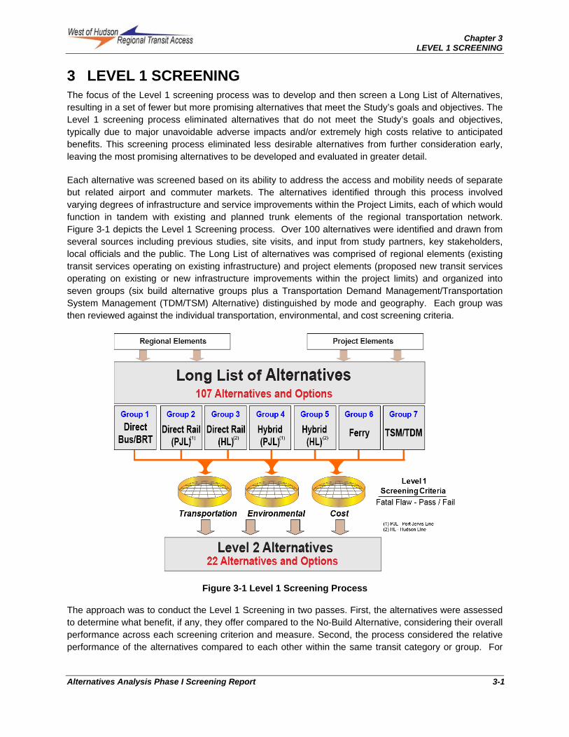
Each alternative was screened based on its ability to address the access and mobility needs of separate but related airport and commuter markets. The alternatives identified through this process involved varying degrees of infrastructure and service improvements within the Project Limits, each of which would function in tandem with existing and planned trunk elements of the regional transportation network. Figure 3-1 depicts the Level 1 Screening process. Over 100 alternatives were identified and drawn from several sources including previous studies, site visits, and input from study partners, key stakeholders, local officials and the public. The Long List of alternatives was comprised of regional elements (existing transit services operating on existing infrastructure) and project elements (proposed new transit services operating on existing or new infrastructure improvements within the project limits) and organized into seven groups (six build alternative groups plus a Transportation Demand Management/Transportation System Management (TDM/TSM) Alternative) distinguished by mode and geography. Each group was then reviewed against the individual transportation, environmental, and cost screening criteria.
Figure 3-1 Level 1 Screening Process
The approach was to conduct the Level 1 Screening in two passes. First, the alternatives were assessed to determine what benefit, if any, they offer compared to the No-Build Alternative, considering their overall performance across each screening criterion and measure. Second, the process considered the relative performance of the alternatives compared to each other within the same transit category or group. For

Chapter 3 LEVEL 1 SCREENING
3-2 Alternatives Analysis Phase I Screening Report
example, where multiple alternatives perform better than No-Build within a particular mode or market, the lowest rated among them would be eliminated in favor of the higher or better performing alternatives.
Section 3.1 discusses the Level 1 alternatives. The Level 1 screening measures are then presented in Section 3.2. The results of the application of these screening measures are presented in Section 3.3.
3.1 Level 1 Alternatives
The Long List of Alternatives for this Study began with a broad examination of potential solutions to the transit access and mobility needs identified for both the commuter and airport markets. Alternatives identified in previous studies, site visits, and input from study partners, key stakeholders, local officials and the public, represented the starting point for this evaluation, which resulted in the generation of the following alternatives and options: No-Build Alternative (Section 3.1.1), Low Cost Transportation Demand Management/Transportation System Management (TDM/TSM) Alternative (Section 3.1.2); and a 107 Build Alternatives (Section 3.1.3). Each of the Build Alternatives were developed at conceptual level, sufficient to perform Level 1 screening and then organized into groupings by mode. The modal groupings, alternative identifiers and markets served are summarized in Table B-1 in Appendix B. Additional descriptive information and details about each alternative is provided in tables B-2, B-3, B-4 and B-5 in Appendix B.
The Long List of Alternatives would generally be located in the corridor between SWF and its vicinity and New York City. Bus and BRT Alternatives would use portions of I-87 and I-84 in existing or modified configurations. The Commuter Market bus and BRT routes would use I-87 to the south, and the Airport Market bus routes would utilize I-87 and I-84 to the east, west, north and south to serve the Mid-Hudson region. For commuter rail alternatives, the Metro-North PJL and Hudson Line were each considered either for direct service extensions or with transfer to a new or improved connecting service. Alternatives also included high-speed ferry service on the Hudson River from Newburgh.
3.1.1 No-Build Alternative
The No-Build Alternative provides the point of comparison against which all other alternatives are measured. It consists of the existing regional transportation network plus projects identified in the region’s adopted Long Range Transportation Plan (LRTP)1 for implementation by the year 2035, which is the projects planning horizon. The No-Build Alternative includes, but is not limited to, the following relevant services and infrastructure:
Existing Regional Bus Services
Existing Commuter Rail and Connecting Services
Existing Haverstraw to Lower Manhattan Ferry Service
Existing Newburgh – Beacon shuttle bus and ferry services
I-87/ I-84 Interchange
New York State (NYS) Route 17 Improvements (I-86)
Access to the Region’s Core (ARC)2
1 WHRTAS will assume the projects identified in the New York Metropolitan Transportation Council and the Orange County Transportation Council adopted LRTP. 2 In November, 2010, the State of New Jersey announced the cancellation of ARC. This change would be expected to alter the assumptions and results reported here for the "build" alternatives that involve commuter-rail service. WHRTAS Phase II will update this analysis using updated official assumptions in the applicable regional transportation plans.
Chapter 3 LEVEL 1 SCREENING
Alternatives Analysis Phase I Screening Report 3-3
Port Jervis Line Improvements
Hudson Line Improvements
New Jersey Transit (NJT) Infrastructure Improvements
2nd Avenue Subway
East Side Access
The highway and transit networks contained in the LRTP
An SWF Airport No-Build scenario defined in consultation with the Port Authority
The No-Build network of express buses and commuter rail lines within the Project Limits and surrounding area is depicted in Appendix B, Figure B-1 (for a definition of Study Area and Project Limits see Section 1.1).
For purpose of analysis, two options for the No-Build alternative were considered relative to Metro-North’s PJL. The standard No-Build, which assumes the existing single track configuration north of Sloatsburg and service plan per the current LRTP; and the WHRTAS No-Build which assumes an MTA modified service plan that occurs with implementation of double track north of Sloatsburg (except Moodna Viaduct), a midpoint yard, and other associated improvements. Refer to Appendix C for service plans.
Complete lists of projects contained in the respective LRTPs of the three Metropolitan Planning Organizations (MPOs) most relevant to the Study Area are available from the following websites;
Orange County Transportation Planning Council: http://www.orangecountygov.com
New York Metropolitan Transportation Council: http://www.nymtc.org/
North Jersey Transportation Planning Authority: http://www.njtpa.org/default.aspx
Consistent with FTA’s AA process, the two No-Build options are automatically carried through the Phase I screening processes.
3.1.2 TDM/TSM Alternatives
Transportation Demand Management (TDM) and Transportation Systems Management (TSM) improvements are relatively low cost strategies and policies to improve efficiency of and address identified access and mobility needs without major capital investment.
Typically, TDM strategies focus on reducing travel demand by implementing programs such as carpools, vanpools, flextime, increased transit usage, walking and bicycling. TSM strategies focus on increasing the efficiency, safety, reliability and optimizes the performance of existing transportation systems through implementation of techniques such as; use of intelligent transportation systems (ITS), real time driver and transit information management programs, incident response plans, targeted traffic enforcement and low cost bus service improvements.
Consistent with FTA’s AA process, the TDM and TSM alternatives are automatically carried through the Phase I screening processes.
3.1.2.1 Commuter Market TDM/TSM
For the commuter market, the TDM/TSM Alternative consists of the No-Build Alternative plus other low-cost roadway and transit system improvements that would be implemented with little or no additional infrastructure requirements, and would have the capability to:
Chapter 3 LEVEL 1 SCREENING
3-4 Alternatives Analysis Phase I Screening Report
Reduce the amount and frequency of commuter trips
Shift the time of travel
Reduce the use of single-occupant vehicle travel
Increase the use of alternative modes such as carpools, vanpools or transit
Improve the flow and operations of vehicular traffic in the commuter corridor
The Commuter TDM/TSM Alternative may include more frequent service on existing regional rail and bus lines, expanded express bus services and park and ride facilities, TDM, Intelligent Transportation Systems (ITS), and improved intermodal connectivity between regional and local transit services. TDM Programs potentially applicable to the project goals include:
Improve physical integration of train and bus services at existing stations on the PJL and the Hudson Line at Beacon
Enforce compliance with scheduled bus-train connections
Promulgate real-time bus-train schedule and delay information
Develop a corridor education and promotion program
Increase funding for outreach to corridor employers
Introduce a car-sharing program
Expand free/reduced toll/fare programs for off-peak users
Expand existing van/carpool programs
Give priority treatment to carpool, vanpool and transit vehicles
3.1.2.2 Airport Market TDM/TSM
A TDM/TSM Alternative to serve SWF would also consist of the No-Build Alternative plus other low-cost roadway and transit system improvements that:
Reduce the use of single-occupant vehicles for SWF access
Increase the use of alternative modes such as carpools, vanpools, or transit
Improve the flow and operations of vehicular traffic accessing SWF
In tandem with the Commuter TDM/TSM Alternative, the TDM/TSM Airport Alternative may include more frequent service on existing regional rail and bus lines, expanded express bus services and park and ride facilities, TDM, Intelligent Transportation Systems (ITS), and improved intermodal connectivity between regional and local transit services. Airport market TDM elements may also include use of shared-ride van services that could be demand responsive, similar to services currently in use at John F. Kennedy International (JFK), Newark Liberty International (EWR) and LaGuardia (LGA) airports.
Some elements of the TDM/TSM Alternative for SWF represent “scalable” (easily expanded or upgraded) options that could be implemented initially as low-cost, early-action items, and expanded over time to meet increased demand.
SWF Airport Express Buses
To address improved access to SWF, the TDM/TSM Alternative will include eight new regional express bus services linked to existing long-term park and ride facilities, using existing highways that provide a non-stop transit option for SWF travelers and employees.

Chapter 3 LEVEL 1 SCREENING
Alternatives Analysis Phase I Screening Report 3-5
It is anticipated that these regional express bus routes would be staged at various Manhattan locations as well as regional collection points such as at long-term remote parking facilities north, south, east and west of SWF as shown in Figure 3-2.
Figure 3-2 Airport Market Scalable TDM/TSM Alternatives

Chapter 3 LEVEL 1 SCREENING
3-6 Alternatives Analysis Phase I Screening Report
For the purpose of this analysis, three routes would originate from Manhattan, one from Stamford CT, one from Suffern NY, one from Danbury CT, one from Kingston NY and one from Sussex NJ. Providing parking facilities at locations serving these routes could offer a lower cost or more convenient alternative to driving and relieve on-airport parking requirements. The eight SWF express bus routes are proposed for inclusion in the TDM/TSM Alternative to be advanced into Level 2 Screening, plus the shared ride shuttle service. See Table B-6 in Appendix B.
The proposed TDM/TSM bus services are “scalable” low-cost, easy-to-implement alternatives. As demand for such bus services increases over time, they could require, a more robust service plan and investment in new or expanded infrastructure. Such improvements would then constitute a potential bus “Build” alternatives version of these TDM/TSM improvements (see Section 3.1.3.1 for description of the “Build” alternatives).
ITS Strategies
ITS strategies maximize the use and efficiency of the existing transportation systems through application of advanced traffic control and travel information systems. Typically, ITS measures are implemented in a comprehensive program combining TDM/TSM measures that support and enhance one another to achieve the desired effect of managing travel demand and traffic operations on a corridor/region-wide basis. Some ITS features already exist in the Study Area, such as electronic tolls on I-87 and passenger information systems on Metro-North commuter rail trains and at stations. These existing elements will serve as the baseline for the definition of additional measures.
3.1.3 Build Alternatives
The Long List of Build Alternatives considered the following components: Service, Technology, and Alignment. Each of the Build Alternatives was comprised of two types of elements: project area and regional elements.
Project area elements are proposed modal services operating on existing infrastructure alignments or new services requiring new infrastructure improvements. In all cases, project area elements are located within the Project Limits. In developing project area elements, the following modal technologies were considered:
AGT Automated Guideway Transit is an electric railway (single or multi-car trains) of automatically guided transit vehicles operating without an onboard crew. Service may be on a fixed schedule or in response to a passenger activated call button.
CRT Commuter Rail Transit is electric or diesel-propelled heavy railway train service operating at high speeds (70-100 mph) and generally long distance, using multiple cars. Stations are generally two or more miles apart in urban areas and further apart in less developed rural areas. CRT is usually fully grade separated or can cross streets at grade. CRT in the NYC Metropolitan region is operated by Metro-North Railroad, Long Island Rail, and New Jersey Transit.
LRT Light Rail Transit (also called streetcar, tramway, or trolley) is electric or diesel operating one, two or three-car train. Usually it is running on exclusive lanes in city arterials or in a separate right-of-way. Generally would operate at slower speeds and travel shorter distance than the CRT.
BRT Bus Rapid Transit is a roadway-based rapid transit system that is in many ways similar to commuter rail service. It offers rapid transit service on reserved lanes both on freeways and

Chapter 3 LEVEL 1 SCREENING
Alternatives Analysis Phase I Screening Report 3-7
city streets, enabling buses to travel at higher speeds and have more reliable travel times. By using roads, BRT doesn’t require expensive tracks and other support infrastructure. Vehicles can be low-emission hybrid electric or powered by compressed natural gas (CNG).
RGB Regional (Commuter/Express) Bus (also known as a commuter bus or public bus) is a bus used in general for medium or long-distance inter-urban public commutation coach transport.
WBT Waterborne Transit (High Speed Ferries) is a transit mode comprising vessels carrying passengers and in some cases vehicles over a body of water, and that are generally steam or diesel-powered.
PED High-Speed Moving Sidewalk is a moving conveyor mechanism that transports people, across a horizontal plane, over a short to medium distance. Typically used in large airport terminals to move pedestrians faster than walking. Pedestrians can either walk while moving or stand to the side. Often are installed in pairs, one for each direction.
For project area element alignments see Figure 3-3.
Regional (or “trunk”) elements are the existing bus or rail services on existing infrastructure or ferry service on a waterway. Together a combination of project area elements and regional elements form a Build Alternative. The Build Alternatives may consist of one or more project area elements or regional elements.
Seven regional elements were identified that provide “trunk” line service in each Build Alternative. The regional elements include bus, BRT, commuter rail, and high speed ferry:
Manhattan-Suffern Regional Bus (MSB). Runs from the Port Authority Bus Terminal (PABT) in Manhattan to Suffern, a distance of approximately 38 miles (approximately 29 miles south of the NJ/NY State Line), via existing highways. Various combinations of highways are possible. An alignment via the Lincoln Tunnel, New Jersey Turnpike, Bergen-Passaic Expressway, Garden State Parkway and New York State Thruway was initially assumed for planning purposes. TSM strategies such as “bus-on-shoulder” operation will be considered to expedite bus travel through congested areas. Both regional express bus and BRT were considered for these alignments.
Manhattan-Suffern Regional Rail (MSR). Runs from a new passenger station under 34th Street/7th Ave to SWF via the new ARC3 tunnels then to Suffern via the NJT Bergen County Line, a distance of approximately 29 miles. A variation using the NJT Main Line would be approximately one mile longer and requires negotiating two segments of single track. For these reasons, operation via the Bergen County Line was initially assumed between Bergen and Ridgewood Junctions for planning purposes.
Salisbury Mills/Cornwall-Port Jervis Regional Rail (JCR). Continues northward from Salisbury Mills-Cornwall Station to Middletown and Port Jervis, a distance of approximately 32 miles, providing a regional link to the project area from the west.
Denniston-Port Jervis Regional Rail (JDR). A subset of Regional Element JCR on the PJL starting at a point designated as “Denniston”, approximately one mile north of Salisbury Mills-Cornwall Station and continuing north to Middletown and Port Jervis, a distance of approximately 31 miles.
3 In November, 2010, the State of New Jersey announced the cancellation of ARC. This change would be expected to alter the assumptions and results reported here for the Build Alternatives that involve commuter rail service. WHRTAS Phase II will update this analysis using updated assumptions in the applicable regional transportation plans.

Chapter 3 LEVEL 1 SCREENING
3-8 Alternatives Analysis Phase I Screening Report
Figure 3-3 General Alignments for Project Area Elements

Chapter 3 LEVEL 1 SCREENING
Alternatives Analysis Phase I Screening Report 3-9
Manhattan-Beacon Regional Rail (MBR). Runs from Grand Central Terminal (GCT) via the Hudson Line to Beacon Station, a distance of approximately 58 miles. For planning purposes and in order to be more comparable with the other regional elements this alternative is assumed to terminate at Penn Station on the west side of Midtown Manhattan.
Beacon-Poughkeepsie Regional Rail (PBR). Continuation of Metro-North’s Hudson Line from Beacon to Poughkeepsie, a distance of approximately 14 miles, providing a regional link for Mid-Hudson region travelers from the north.
Manhattan-Newburgh High Speed Ferry (MNW). High speed ferry service on the Hudson River from the ferry terminal at the foot of 39th Street in Manhattan to the ferry terminal in Newburgh, a distance of approximately 56 miles. Access to and from SWF Airport would be via a dedicated express bus shuttle, adding a transfer and approximately seven miles to the overall journey.
For a more detailed description of the above regional elements see maps and tables in Appendix B.
Project Area Elements
The project area elements provide the physical connection between the regional elements and the targeted commuter and airport markets, which are generally located at or near SWF. These elements are common to more than one alternative. The project area elements include connections using existing or new right-of-way of a variety of potential transit modes as summarized below.
Highway-Based Transit Elements
The highway-based alternative elements offer the easiest opportunities for a “one-seat ride” direct to SWF from the north, south, east, and west, and for service to NYC from central Orange County. The initial general alignments identified for the project elements are illustrated in the context of the project area in Appendix B, Figure B-2. For planning purposes a network of regional express bus/BRT services was identified with project area elements terminating on the north and south sides of the airport using either the existing highway network and interchanges to reach the commuter park and ride and the airport terminal, or the option of building new bus-only slip ramps which reduce travel time from the south, particularly for the airport market. The slip ramp option and related bus services are summarized below:
1. North Corridor Regional Bus (SNB): This service would exit I-87 via new bus-only slip ramps near the intersection of Routes 300 and 207. It would then continue to downtown Newburgh via Routes 300 and 17K. It would also stop at the existing Route 17K park and ride (Newburgh) and a new park and ride proposed at the base of the new slip ramps.
2. SWF Airport Regional Bus (SAB): This service would exit I-87 via the same bus-only slip ramps noted above, near the intersection of Routes 300 and 207. It would then continue on a short dedicated busway or in mixed traffic to the SWF passenger terminal.
The first of these regional bus elements is predominately oriented to commuter markets while the second is oriented to SWF travelers and employees.

Chapter 3 LEVEL 1 SCREENING
3-10 Alternatives Analysis Phase I Screening Report
Metro-North Port Jervis Line Elements
Port Jervis Line project area elements provide service from the existing PJL to SWF. A variety of connecting services were examined (see Figure 3-4):
One element would operate from a point one-half mile north of the PJL Salisbury Mills-Cornwall Station via new right-of-way to a South-Side transit station located south of the main airport runway, a distance of approximately four miles. This element could make use of AGT, LRT, BRT or express bus for a shuttle service from PJL trains, or regional (commuter) rail.
Another element would operate from a point approximately one mile north of the PJL Salisbury Mills-Cornwall Station designated as “Denniston”, and continues north and east via new right-of-way to reach the SWF passenger terminal area, a distance of approximately 8 miles.
A third element would operate from the PJL Campbell Hall Station via an abandoned railroad alignment through Maybrook, along the south side of I-84 to a North-Side transit station located north of the main airport runway, a distance of approximately 11 miles. This element could make use of AGT, LRT, BRT or express bus for a shuttle service from PJL trains, or regional (commuter) rail.
A fourth element would operate along the I-87 alignment starting from a point near departing the PJL near Woodbury and continues to the transit station located on the South-Side of the main airport runway. The alignment is approximately 13 miles long. This element would use the I-87 right-of-way as much as possible to minimize land acquisition in the SWF area. The alignment would branch from the PJL near Woodbury, where the PJL is nearly the same elevation as, and relatively close to I-87.
Metro-North Hudson Line Elements
Hudson Line elements provide service from Beacon Station on the Hudson Line to SWF. A variety of connecting services were examined:
From Beacon Station, this element would operate via new right-of-way, the southernmost lane of the Beacon-Newburgh Bridge, the south side of I-84, other new right-of-way to the North-Side transit station, a distance of approximately seven miles. This element could make use of AGT, LRT, BRT, or express bus for a shuttle service from Hudson Line trains, or possibly regional (commuter) rail for a direct, “one-seat ride” (Subject to the feasibility of taking a lane or shoulder on the I-84 bridge for transit use. The commuter rail option would also be dependent upon a structural evaluation of the Newburgh-Beacon Bridge).
From Beacon Station, this element would operate via new right-of-way, the southernmost lane of the Beacon-Newburgh Bridge, the south side of I-84, and other new right-of-way to the North-Side transit station, a distance of approximately eight miles.
From Beacon Station, this element would operate via new right-of-way, the southernmost lane of the Beacon-Newburgh Bridge, the south side of I-84, and other new right-of-way to the South-Side transit station, a distance of approximately nine miles.

Chapter 3 LEVEL 1 SCREENING
Alternatives Analysis Phase I Screening Report 3-11
Figure 3-4 Project Area Alignments (SWF Airport Detail)

Chapter 3 LEVEL 1 SCREENING
3-12 Alternatives Analysis Phase I Screening Report
Ferries
The high speed ferry alternative requires a project area element consisting of a dedicated express shuttle bus between the ferry terminal(s) in Newburgh to SWF, a distance of approximately seven miles.
Proposed SWF Station and Parking
Current plans call for the SWF passenger terminal to remain close to its present location on the south side of the airfield. Two general on-airport transit station sites for intermodal transfer were considered for the project area elements connecting to SWF. Figure 3-4 depicts these potential locations for terminating the alternative alignments:
A South-Side transit station located in the vicinity of the existing SWF terminal building.
A North-Side transit station which would require an underground passenger connection (either moving sidewalks or AGT system passing beneath the runways) to access the terminal building. The North-Side transit station is located on the north side of Route 17K.
The highway-based regional express bus/BRT alternatives would offer the opportunity to combine airport and commuter parking at an off-airport satellite location. Municipal property adjacent to I-87 would allow for combining airport parking with commuter parking for the South-Side transit station alignment elements. The North-Side transit station option would offer a similar opportunity at satellite locations with direct highway access. Alternatives that consider the North-Side transit station, access to the airport passenger terminal would be by moving sidewalks or an AGT system beneath the runways.
3.1.3.1 Alternative Groups
To clarify the similarities and differences among the Build alternatives and facilitate their evaluation, the alternatives were organized into six major groups based on mode and geography. TDM/TSM Alternatives were considered as a separate seventh group (see section 3.1.2). The six Build alternative groups are:
Alternative Group 1: Direct Regional Bus/BRT for Commuter and Airport Markets (19 alternatives)
Alternative Group 2: Direct Commuter Rail from Port Jervis Line (PJL) (32 alternatives)
Alternative Group 3: Direct Commuter Rail from Hudson Line (Beacon) (4 alternatives)
Alternative Group 4: Hybrid Commuter Rail from Port Jervis Line (PJL) (32 alternatives)
Alternative Group 5: Hybrid Commuter Rail from Hudson Line (Beacon) (18 alternatives)
Alternative Group 6: Regional Ferry Service (2 alternatives)
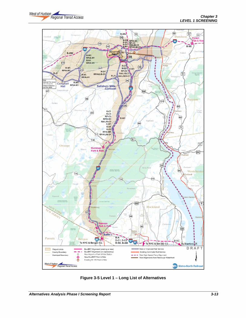
Each of these alternative groupings is described below. Specific Build Alternatives are shown in Figure 3-5 and summarized in Table B-1, Appendix B. Each alternative is also described and shown in detail in Appendix B.
Chapter 3 LEVEL 1 SCREENING
Alternatives Analysis Phase I Screening Report 3-13
Figure 3-5 Level 1 – Long List of Alternatives
Chapter 3 LEVEL 1 SCREENING
3-14 Alternatives Analysis Phase I Screening Report
Alternative Group 1: Direct Regional Bus for Commuter and Airport Markets [B-C1, B-C2, B-XM, B-XG, B-XH (commuter and airport), B-XN, B-XE, B-XW, B-XS, B-XC, B-XD, B-X, B-
XHA, B-XWP (airport only)]
The key feature of Alternative Group 1 is that it provides direct regional bus service options to both commuter and airport markets. This group consists of 19 alternatives and options.
Alternatives such as B-C1, B-C2, B-XC, B-XM, B-XD, B-XG, B-XS, and B-XHA would provide regional service from the south and would use I-87 as much as possible to minimize land acquisition requirements associated with new right-of-way. These services would exit I-87 via newly constructed bus-only slip ramps near the intersection of Routes 300 and 207. The slip ramps would provide direct access to SWF from the south. Alternative B-C would continue via Routes 300 and 17K and stop at the existing Route 17K park and ride (Newburgh) and a new park and ride proposed at the base of the new slip ramps. Alternatives B-XC, B-XM, B-XD, B-XG, B-XS, and B-A would continue in mixed traffic or on a short dedicated busway to the SWF passenger terminal.
Alternative B-XN would provide direct regional bus service for airport markets from the north. It would start from a new park and ride near Kingston and use the I-87 alignment with a possible intermediate stop at New Paltz.
Alternative B-XW would provide direct regional bus service for airport markets from the west. It would utilize the I-84 alignment that starts from the Sussex park and ride in New Jersey and continues to the Middletown park and ride along I-84. It would then continue east to SWF.
Alternative B-XE would provide direct regional bus service for airport markets from the east. It would utilize the I-84 alignment that starts from a new park and ride lot near Danbury or Brewster, Connecticut and provide service for airport travelers and employees.
Alternative Group 2: Direct Commuter Rail from Port Jervis Line (PJL) for Commuter and Airport Markets [R-C1, R-C3, (includes options – R-C1.1, R-C1.2/3, R-C1.4, R-C1.5, R-C1.6, R-C3.1, R-C3.2/3, R-C3.4, R-C3.5) R-W1, R-W2, R-W3, R-H1, R-M1, R-D1 and R-J1 – all both commuter and airport]
The key feature of Alternative Group 2 is that the alternatives would provide direct commuter rail service to both commuter and airport markets using an extension of the existing PJL. This group consists of thirty alternatives and options, which are shown in Appendix B, Figures B-6, B-7 and B-8, and Table B-3.
Alternatives R-C1, R-C3 and R-J1 would use the Salisbury Mills-Cornwall alignment along the PJL. The Salisbury Mills-Cornwall alignment starts from a point one-half mile north of Salisbury Mills-Cornwall Station via new right-of-way and 2nd Street to the south side of SWF.
Alternatives R-W1 and R-W2 would generally parallel the I-87 alignment to the south side of SWF. The alignment would branch from the PJL near Woodbury and use portions of I-87 right-of-way as much as possible to minimize land acquisition requirements in the SWF area. Alternative R-W1 follows the west side of I-87 then crosses over Route 207 and enters SWF airport from the southeast. Alternative R-W2, suggested by a member of the public, is a variation of Alternative R-W1 that would follow the east side of I-87 and then along various active and abandoned rail lines reaching east of Route 32 before heading west to SWF.
Alternatives R-H1 and R-M1 would provide direct regional rail service to SWF via Control Point (CP) Hudson and Campbell Hall alignments that branch from the PJL south of Maybrook at CP Hudson, and
Chapter 3 LEVEL 1 SCREENING
Alternatives Analysis Phase I Screening Report 3-15
the Campbell Hall Station, respectively. The CP Hudson and Campbell Hall alignments would merge into one alignment in Maybrook that would use an abandoned railroad right-of-way through Maybrook and new right-of-way generally parallel to the south side of I-84 to reach the north side of SWF.
Alternative R-D1 would provide direct commuter rail service via the proposed Denniston alignment from the PJL. The proposed Denniston alignment branches from PJL at a point designated as “Denniston”, approximately one mile north of the Salisbury Mills-Cornwall Station and continues north and east to reach the SWF passenger terminal area.
Alternative Group 3: Direct Commuter Rail from Hudson Line (Beacon) [R-B1, R-B3 (commuter and airport)]
Alternative Group 3 would provide direct commuter rail from Beacon Station to SWF and would serve both the commuter and airport markets. This alternative group would provide direct commuter rail services from GCT to SWF via the Hudson Line and a new bridge across the Hudson River. On the west side of the Hudson River, these alternatives would operate via new right-of-way parallel to the south side of I-84 and terminate at a station on either the south or north side of the airport. This group consists of 4 alternatives and options (see Appendix B, Figures B-9 and B-10, and Table B-3).
Alternative Group 4: Hybrid Commuter Rail with AGT, BRT or LRT from Port Jervis Line (PJL) [RP-C3, RA-C3, RL-C3, RB-C3, RP-D1, RA-D1, RL-D1, RB-D1, RP-H1, RP-M1, RA-M1, RA-C1, RL-C1, RB-C1, RX-C1 – all both commuter and airport]
Alternative Group 4 would provide commuter rail service to both the commuter and airport markets from the south by using the Metro-North PJL to one of the existing commuter rail station locations where passengers would then transfer to another transit mode for connecting services to SWF and/or a commuter park and ride. Modes considered for these connecting services include AGT, BRT, LRT, and express bus service. This group consists of 32 alternatives and options. The alternatives are shown in Appendix B, Figures B-6 and B-8, and Table B-4.
Alternatives RP-C3, RA-C3, RL-C3, RB-C3, RA-C1, RL-C1, RB-C1, and RX-C1 would operate via the Salisbury Mills-Cornwall alignment along the PJL. The Salisbury Mills-Cornwall alignment would start from a point one-half mile north of Salisbury Mills-Cornwall Station via new right-of-way and Second Street to SWF South-Side transit station. Alternative RP-C3 would provide a high speed moving sidewalk to the north-side station from the SWF terminal. Alternatives RA-C3 and RA-C1 would use AGT to connect from Salisbury Mills/Cornwall to SWF. Alternatives RL-C3 and RL-C1 would use LRT, Alternatives RB-C3 and RB-C1 would use BRT, and Alternative X-C1 would use express bus service.
Alternative RP-D1would use commuter rail transit via the Denniston alignment that would branch from the PJL starting at a point one mile north of Salisbury Mills-Cornwall Station, and continue northward to the North-Side transit station. It would then connect to SWF terminal via high-speed moving sidewalk. Alternatives RA-D1, RL-D1, and RB-D1 are similar to RP-D1 but they provide connection from the north-side station to the terminal via AGT, LRT and bus services, respectively.
Alternatives RP-H1, RA-H1, RP-M1, RA-M1 would provide hybrid commuter rail service to SWF via the CP Hudson and Campbell Hall alignments that branch from the PJL south of Maybrook at the CP Hudson and Campbell Hall Stations, respectively. The CP Hudson and Campbell Hall alignments would merge and use an abandoned track through Maybrook and new right-of-way along the south side of I-84 to the North–Side transit station and connect to the SWF terminal via high speed moving sidewalk that would operate underneath the runway.

Chapter 3 LEVEL 1 SCREENING
3-16 Alternatives Analysis Phase I Screening Report
Alternative Group 5: Hybrid Commuter Rail from Hudson Line (Beacon) [RA-B1, RL-B1, RB-B1, RX-B1, RP-B3, RAs-B3, RL-B3, RB-B3 – all both commuter and airport]
Alternative Group 5 would provide commuter rail service to both the commuter and airport markets via Metro-North’s Hudson Line to Beacon Station on the east side of the Hudson River where passengers would then transfer to another mode for connecting services to SWF and/or a commuter park and ride on the west side of the Hudson River. The connecting service would be via the existing I-84 bridge or a new bridge over the river. On the west side of the Hudson River, the alternatives would operate via existing I-84 or a new right-of-way parallel to and south of I-84 and would connect to SWF on the north or south of the airport via a connecting AGT, BRT, LRT, or express bus service to the SWF Terminal. This group consists of nine alternatives: RA-B1, RL-B1, RB-B1, RX-B1, RP-B3, RA-B3, RAs-B3, RL-B3 and RB-B3. These alternatives are shown in Appendix B, Figures B-9 and B-10, and Table B-4.
Alternatives RA-B1, RL-B1, RB-B1, and RX-B1 would operate on new right-of-way on the south side of I-84 and connect to South-Side transit station.
Alternatives RP-B3, RA-B3, RAs-B3, RL-B3 and RB-B3 would operate on new right-of-way on the south side of I-84 and would connect to North-Side transit station.
Alternative Group 6: Regional Ferry Service [WB-N – commuter and airport]
Alternative Group 6 would provide high-speed ferry service on the Hudson River to both the commuter and airport markets. The high-speed ferry service would begin from the ferry terminal at the foot of 39th Street in Manhattan to the ferry terminal in Newburgh, a distance of approximately 56 miles. A dedicated shuttle bus would provide connecting service between the ferry terminal in Newburgh and SWF. Alternative Group 6 includes two alternatives, WB-N for both commuter and airport markets as shown in Appendix B, Figures B-11 and B-12, and Table B-5.
3.2 Level 1 Screening Measures and Methodologies
The evaluation of the alternatives during the Level 1 Screening was based on three main criteria that reflect the project’s goal and objectives:
Transportation
Environmental
Cost
At Level 1, the screening performance measures were primarily qualitative, which relied on professional judgment within generally defined parameters. The description for each of the performance measures under the three main criteria are shown in Table 3-1 and defined below. Level 1 screening measures were applied accordingly to both the commuter and airport market.
For example: User Benefits Measure – Potential to Reduce Travel Time: This measure was used to evaluate alternatives that would provide a reduced travel time over the No Build. In the case of bus alternatives, when initially no infrastructure improvements are being considered, the buses would operate over existing roadways and therefore would offer no operating advantage compared to No Build Alternative. (For details see Level 1 Screening Methodology Tech Memo, March 2009)

Chapter 3 LEVEL 1 SCREENING
Alternatives Analysis Phase I Screening Report 3-17
Table 3-1 Level 1 Screening Measures
The alternatives were developed at a conceptual level sufficient to make an appropriate assessment and rating to perform Level 1 Screening. Each alternative was evaluated and assigned a rating on a preliminary basis in one of the following ways, as applicable for each of the performance measures.
High, Medium, Low: Most measures received a level of effectiveness rating depending on its ability to achieve benefits and avoid adverse impacts.
Yes/No: Some measures resulted in a pass (Yes) or fail (No), such as whether the alternative has the potential to reduce the number of transfers compared to the No-Build.
Numerical Result: Only the order of magnitude capital cost measures were expressed numerically. Some measures, such as potential to reduce travel time, have a numerical estimate, but most were given a qualitative rating of high, medium, or low.
Once the ratings were reviewed and finalized, the better performing alternatives were recommended to be retained for further development and evaluation in Level 2 Screening, while those with major flaws were recommended to be dropped. If it was not possible to determine whether an alternative should be dropped based on Level 1 Screening, it was retained for Level 2 Screening.
3.2.1 Transportation
The measures within the transportation category were used to evaluate each alternative in terms of the relative improvement in mobility and accessibility they would provide for the airport and commuter markets. The alternatives were also evaluated in terms of their compatibility with the existing transportation system as well as their potential to increase user benefits. The measures used to rate the alternatives are described below. It is important to note that this level of analysis relied largely on existing information and data provided in previous studies. Ratings on transportation performance were based on professional judgment and assessment, guided by an understanding of future travel conditions within the
Chapter 3 LEVEL 1 SCREENING
3-18 Alternatives Analysis Phase I Screening Report
study area and rated using a High, Medium or Low scale (See Appendix B for rating details on the following measures).
The performance measures were:
Capacity - Assessed the potential of the alternative to increase the capacity of the existing transportation system within the Study Area.
User benefits - Assessed the potential of the alternative to reduce transit travel times for the airport and commuter markets.
Integration with Existing System - Assessed how easy an alternative would integrate with the existing transportation system to provide a seamless passenger experience.
Mobility - Assessed how well the alternative would improve transit service levels and regional intermodal connections.
Accessibility – Assessed how well the alternative would enhance the ability of the public to access and use the transit system.
3.2.2 Environment
Potential environmental effects of each alternative were identified using existing documentation, such as geographical information systems (GIS). Each alternative was rated based on the ability to avoid major adverse impacts to the natural and built environment based on High, Medium or Low scale.
An alternative was rated higher if it avoids major impacts, medium if it had some adverse impacts and low if it had major unavoidable adverse impacts to the environment.
3.2.3 Cost
This category was used to asses relative cost of providing the infrastructure associated with each Build Alternative, order of magnitude capital costs (in 2009 dollars) were estimated based on unit costs applied to quantity approximations.
Order of magnitude costs were not a primary screening tool, but rather used to help in the decision making process where alternatives at Level 1 are very similar across the qualitative screening measures. The cost estimates were developed for comparison purposes only using a High (>$250 million), Medium ($50 million-$249 million), or Low (<$50 million) ranges. The details needed to develop a full capital cost estimate for the surviving alternatives are in Chapter 4.
3.3 Level 1 Screening Results Using the measures described in Section 3.2, the Level 1 Screening was conducted focusing on eliminating those alternatives with major flaws based on criteria related to the compatibility of the mode with project goals, compatibility with surrounding land uses, and overall engineering feasibility. During the screening, alternatives were subjected to two “pass” processes. During first “pass”, alternatives where evaluated and dropped when major flaws were identified using the criteria measures. During the second “pass”, the remaining alternatives were then compared qualitatively to each other and the better performing alternatives would advance to Level 2. This process identified 224 alternatives (21 build
4 At the conclusion of the Level 1 Screening, 36 Alternatives and Options remained . However, during the Level 1 Screening it was observed that characteristics of many of the alternatives are similar for both airport and commuter markets. Therefore, for evaluation purposes and to simplify the analysis, these alternatives were consolidated into 22 distinct alternatives and options.

Chapter 3 LEVEL 1 SCREENING
Alternatives Analysis Phase I Screening Report 3-19
alternatives and options plus the TDM/TSM alternative) for further development and evaluation in Level 2. In general, the Build alternative modes that survived the Level 1 Screening were direct commuter rail, direct bus (which includes BRT), and the alternatives requiring transfers between commuter rail and bus/BRT services, called hybrid services for the purpose of this study.
3.3.1 Key Findings by Alternative Group
For each alternative grouping, the screening measures were applied to both the airport and commuter markets. The distinguishing features of each alternative grouping and the key findings at the group level are summarized below. The results and recommendations of alternatives to advance to Level 2 Screening and analysis are exhibited in Table 3-2.
In the Level 1 Screening, it was determined that all alternatives that were connecting to transit stations on the north side of SWF would require a long and technically complex tunnel beneath the main runway to reach the air passenger terminal to serve the airport market. For this reason and due to the added travel time and cost of the considerably longer rail alignment needed to reach the North-Side transit station of SWF, these alternatives were dropped from further consideration.
Alternative Group 1: Direct Regional Bus Alternatives
Alternative Group 1 provides a number of direct regional bus service options and is further broken out into commuter and airport markets. This group includes bus and BRT alternatives.
Key Findings: Two alternatives advanced to Level 2 Screening and analysis.
Because none of the alternatives in Group 1 exhibit major flaws, it was recommended they be advanced to Level 2 Screening. The two major all-bus alternatives are those that serve the Mid-Hudson region (4 route options) and those that serve NYC and its immediate suburbs (8 route options). Each provided a single seat ride with overall performance capable of serving each market with routing flexibility and scalable capacity over time.
Alternative Group 2: Direct Commuter Rail from Port Jervis Line (PJL)
Alternative Group 2 would provide direct commuter rail service and were further broken out into commuter and airport markets using an extension of the existing PJL. The extension alternatives from east to west are the Thruway alignment; Salisbury Mills Cornwall; Denniston; CP Hudson; and Maybrook. Some of the alternatives had one or more options.
Key Findings: One alternative advanced to Level 2 Screening and analysis.
In this group, the most promising alternative was Salisbury Mills R-C1, a direct commuter rail extension from the PJL north of the existing Salisbury Mills-Cornwall Station. A total of five alignment options were evaluated for the Salisbury Mills-Cornwall alternative and two of them, options R-C1.4 and R-C1.2/3, were recommended to advance. The others were more expensive, slower, or had more negative impacts. A sixth option for this alternative that would follow the Catskill Aqueduct north of Jackson Road known as RC-6 was also evaluated and was recommended to advance, along with a variation of Alternative R-C3, referred to as Option R-C3.4.

Chapter 3 LEVEL 1 SCREENING
3-20 Alternatives Analysis Phase I Screening Report
Table 3-2 Level 1 Screening Results and Recommendations
Grouping Alternative
Level 1 Screening Results and Recommendations
Airport Market Commuter Market
Rating Recommendation Rating Recommendation
Group 1
Direct Regional
Bus
B-C1 High/Medium High/Medium B-C2 High/Medium High/Medium B-XN High N/A N/A
B-XE High N/A N/A
B-XW High N/A N/A
B-XS High N/A N/A
B-XC High N/A N/A
B-XM High High B-XD Medium X N/A N/A B-XG High High B-X High N/A N/A
B-XH Medium Medium B-XHA Medium N/A N/A
B-XWP Medium N/A N/A
Group 2
Direct CRT via PJL Penn
Station
R-C1.1 Medium X Medium X
R-C1.2/3 High High
R-C1.4 High High
R-C1.5 Medium X Medium X
R-C1.6 High/Medium To be
Determined
R-C3.1 Medium X Medium X
R-C3.2/3 Medium X Medium X
R-C3.4 High/Medium High/Medium
R-C3.5 Medium X Medium X
R-W1 Medium X Medium X
R-W2 Medium X Medium X
R-W3 Medium X Medium X
R-H1 Medium/Low X Medium/Low X
R-M1 Medium/Low X Medium/Low X
R-D1 Medium/Low X Medium/Low X
R-J1 Medium/Low X Medium/Low X Group 3
Direct CRT via Beacon
GCT
R-B1 Medium/Low X Medium/Low X
R-B3 Medium/Low X Medium/Low X

Chapter 3 LEVEL 1 SCREENING
Alternatives Analysis Phase I Screening Report 3-21
Table 3-2 Level 1 Screening Results and Recommendations (continued)
Grouping Alternative
Level 1 Screening Results and Recommendations
Airport Market Commuter Market
Rating Recommendation Rating Recommendation
Group 4
Hybrid CRT via PJL
RP-C3 Medium/Low X Medium/Low X
RA-C3 Medium/Low X Medium/Low X
RL-C3 Medium/Low X Medium/Low X
RB-C3 Medium/Low X Medium/Low X
RP-D1 Medium/Low X Medium/Low X
RA-D1 Medium/Low X Medium/Low X
RL-D1 Medium/Low X Medium/Low X
RB-D1 Medium/Low X High/Medium X
RP-H1 Medium/Low X Medium/Low X
RA-H1 Medium/Low X Medium/Low X
RP-M1 Medium/Low X Medium/Low X
RA-M1 Medium/Low X Medium/Low X
RA-C1 Medium/Low X Medium/Low X
RL-C1 Medium/Low X Medium/Low X
RB-C1 High/Medium High/Medium
RX-C1 High/Medium High/Medium
Group 5
Hybrid CRT via Beacon
RA-B1 Medium/Low X Medium/Low X
RL-B1 Medium/Low X Medium/Low X
RB-B1 High/Medium High/Medium
RX-B1 High/Medium High/Medium
RP-B3 Medium/Low X Medium/Low X
RA-B3 Medium/Low X Medium/Low X
RAS-B3 Medium/Low X Medium/Low X
RL-B3 Medium/Low X Medium/Low X
RB-B3 Medium/Low X Medium/Low X
Group 6 High Speed
Ferry WB-N Low X Low X
Group 7 TDM/TSM
Various Pass Pass
Key
= Advance to Level 2 X = Drop

Chapter 3 LEVEL 1 SCREENING
3-22 Alternatives Analysis Phase I Screening Report
The I-87 alignment alternative options R-W1 and RW2 were not recommended because although they had strong potential for travel time savings, they had greater potential adverse impacts, and would be more difficult to integrate operationally into the PJL. Additionally, they were higher cost compared to other more direct rail extensions. Comments received during the screening process from the New York State Thruway Authority (NYSTA) also cited concerns over further consideration of these alignments.
The R-W3 I-87 alignment would travel east into Newburgh and then back west to reach SWF, thereby adding travel time and cost. It also had coordination issues with an existing freight line and major adverse environmental impacts. For these reasons, plus those already mentioned for R-W1 and R-W2, the R-W3 alternative was not recommended to advance.
The Denniston, CP Hudson, and Campbell Hall/Maybrook alternatives to the west were all not recommended to advance because of major flaws relative to environmental impacts, travel time, and operations. Additionally, they had higher magnitude costs compared to other more direct rail extensions.
Alternative Group 3: Direct Commuter Rail from Hudson Line (Beacon)
Alternative Group 3 would provide direct rail service from Beacon on the Hudson Line to commuter and airport markets. These alternatives would require a new bridge across the Hudson River and new right-of-way along the south side of I-84.
Key Findings: No alternative advanced to Level 2 Screening and analysis.
No alternatives within Group 3 were recommended to advance to Level 2 Screening due to a combination of major adverse environmental impacts, new structures required to cross the Hudson River and extremely high cost relative to anticipated benefits.
Alternative Group 4: Hybrid Commuter Rail from Port Jervis Line
Alternative Group 4 would provide commuter rail service in combination with a connector transit service to both the commuter and airport markets from the south by using the PJL to one of the existing commuter rail stations where passengers would transfer to another transit mode. The transit mode would provide connecting service to SWF and/or a new commuter park and ride lot. Modes considered for this connecting service include AGT, BRT, LRT, express bus service, and shuttle buses.
Key Findings: Two alternatives advanced to Level 2 Screening and analysis.
Hybrid alternatives RB-C1 and RX-C1 would use bus or BRT as the connector service from the Port Jervis Line and were recommended to advance because they are relatively low cost and have the potential to address the commuter and airport markets.
Hybrid RB-D1 was eliminated due to the lengthy tunnel that would be required beneath active runways. All other hybrid alternatives in this group involved LRT or AGT connecting service. Limited sites existed for siting a stand-alone heavy maintenance facility, the cost would be high, and LRT and AGT service is less flexible and scalable compared to the bus or BRT connecting services. For example, in the near term connecting service could be via shuttle bus over existing roadways, which could be scaled up to BRT on a busway occupying the preferred long-term direct rail alignment. As demand grows, the mid-term BRT connector service could transition to the long-term single seat CRT alternative, with the flexibility of maintaining shuttle bus service in mixed traffic during conversion of the BRT busway to CRT.

Chapter 3 LEVEL 1 SCREENING
Alternatives Analysis Phase I Screening Report 3-23
Alternative Group 5: Hybrid Commuter Rail from Hudson Line (Beacon)
Alternative Group 5 would provide commuter rail service to both the commuter and airport markets via the Hudson Line from Beacon Station to SWF. Alternative Group 5 would provide commuter rail services from Manhattan to SWF via the Hudson Line and a new bridge across the Hudson River (LRT and AGT) or the existing bridge (bus and BRT).
Key Findings: Two alternatives advanced to Level 2 Screening and analysis.
The bus and BRT alternatives RB-B1, RX-B1, were recommended to advance based on a combination of flexibility, potential travel time savings, and much lower magnitude cost compared to other hybrid alternatives. Alternatives that would involve LRT or AGT as the connector service would require a new bridge across the Hudson River with adverse environmental impacts and high magnitude costs similar to those in Group 3.
Alternative Group 6: Regional Ferry Service
Alternative Group 6 would provide high-speed ferry service on the Hudson River to both the commuter and airport markets. The high-speed ferry service would begin from West 39th Street in Manhattan to the ferry terminal in Newburgh, a distance of approximately 56 miles. A dedicated express shuttle bus would provide service between Newburgh and SWF.
Key Findings: No alternatives advanced to Level 2 Screening and analysis.
The High Speed Ferry alternative was not recommended to advance due to its low ratings for travel time, reliability, mobility and connectivity.
Alternative Group 7: TDM/TSM Alternatives
Alternative Group 7 provides possible low cost Transportation Demand Management (TDM) strategies and low cost Transportation Systems Management (TSM) alternatives for the airport and commuter markets. TDM/TSM are not Build alternatives, but some of the strategies and alternatives are similar to the bus alternatives listed in Alternative Group 1.
Key Findings: All alternatives advanced to Level 2 Screening and analysis.
The list of potential TDM/TSM for each market are listed in the Long List Alternatives report and have been assigned a preliminary rating on a Pass/Fail basis in the detailed matrices.

Chapter 3 LEVEL 1 SCREENING
3-24 Alternatives Analysis Phase I Screening Report
This page intentionally left blank.