pavement structural assessment using automated tools …
TRANSCRIPT

Malaysian Journal of Civil Engineering 29 Special Issue (1):129-152 (2017)
All rights reserved. No part of contents of this paper may be reproduced or transmitted in any form or by any means
without the written permission of Faculty of Civil Engineering, Universiti Teknologi Malaysia
REVIEW PAPER
PAVEMENT STRUCTURAL ASSESSMENT USING AUTOMATED TOOLS:
A COMPARATIVE STUDY
Nurul Hidayah Muslim1, Mohamad Ibrahim Mohamed
1, Zulkarnaini
Mat Amin2, Arezou Shafaghat
3,4, Mohammad Ismail
1 & Ali
Keyvanfar3,4,5
*
1 Faculty of Civil Engineering, Universiti Teknologi Malaysia, 81310 Skudai,
Johor Bahru, Malaysia 2 Faculty of Science and Geomatic Engineering, Universiti Teknologi Malaysia, 81310 Skudai,
Johor Bahru, Malaysia 3Center of Built Environment in the Malays World (KALAM) and Institute Sultan Iskandar (ISI),
Faculty of Built Environment, Universiti Teknologi Malaysia, Skudai 81310, Johor, Malaysia; 4The School of Architecture and Environmental Design, Iran University of Science and
Technology (IUST), Narmak Street, Tehran, Iran 5Universidad Tecnológica Equinoccial, Facultad de Arquitectura y Urbanismo, Calle
Rumipamba s/n y Bourgeois, 170508, Quito, Ecuador
*Corresponding Author: [email protected]
Abstract: Pavement distress evaluation was traditionally conducted through visual observation.
Traditional practice requires a person to walk along the stretch of pavement in order to survey
distresses, take photos, and measure defects occurred at the deteriorated surface. However, this
approach is too subjective causes inconsistencies of information, less reliable and time-
consuming. Due to these shortcomings, the practitioners in pavement maintenance sector seek for
a reliable alternative tools and techniques to arrest incapability of traditional approach. This
research aimed to investigate feasibility of automated tools for pavement structural assessment
conducting a comparative study. Series of interviews with expert panels and comparison matrix
have been conducted comparing Ground Penetrating Radar (GPR), Infrared Thermograph (IR),
and Portable Seismic Pavement Analyzer (PSPA) by investigating across parameters; cost-time
effectiveness, operating principle, depth of performance, method of application, and limitations
of pavement evaluations. The research indicated the Ground Penetrating Radar (GPR) is highly
advantageous over IR and PSPA for pavement structural assessment. The GPR, as a geophysical
tool, has extensive capabilities to accommodate data in pavement assessment, geotechnical
investigation and structural assessment. GPR can considerably perform at high speed and save
time. It is also beneficial for long-term investment with deeper information. Notably, the
interpretation of radar gram images of GPR tool needs sufficient time and skill.
Keywords: Pavement assessment, Geophysical tools, Ground penetrating radar (GPR), Infrared
thermograph (IR), Portable seismic pavement analyser (PSPA)

130 Malaysian Journal of Civil Engineering 29 Special Issue (1):129-152 (2017)
1.0 Introduction
There are numerous technical definitions of good pavement by which the utmost
comfort for users to commute is essential. The pavement upkeep issues became crucial
in order to serve public satisfaction which later demands for better and effective
pavement distress management. The increasing shift in resource allocation from new
pavement construction to pavement rehabilitation highlights the importance of accurate
and comprehensive assessment of deteriorating pavements (Mooney et al., 2000).
Traditionally, pavement distress survey has been conducted through human observation,
interpretation and effort manually. A person can walk along a stretch of pavement to
conduct pavement distress survey, take photo and measurements of defects occurred at
deteriorate surface within the pavement stretch. According to Oh (1998), visual survey
is a common method used by most of engineers, however it lead to significant
drawbacks such as; slow in progress, labour intensive, and expensive, subjective
approach generating inconsistencies and inaccuracies in the determination of pavement
condition, inflexible and does not provide an absolute measure of the surface. Also, it
has poor repeatability since the assessment of given pavement section may be differ
from one survey to the next, and could expose a serious safety hazard to the surveyors
due to high speed and high volume traffic.
There are various approaches have been made and introduced to tackle above drawbacks.
The advancement in technology has applied geophysical tools into pavement distress
evaluation which proven as non-destructive test (NDT) method with extensive amount
of data to be obtained and assists remedial works. A variety of remote sensing, surface
geophysical, borehole geophysical and other non-destructive methods can be used to
determine conditions of bridges and roads (Benson, 2003). The advantages of
performing geophysical tests include faster and economical testing, non-destructive
methods, provide theoretical basis for interpretation, and applicable for soil and rocks
(Federal Highway Administration, 2005). Conclusively, the significant of this study is
to investigate the geophysical tools for pavement distress evaluation in Malaysia
due to its effectiveness in cost, time and perseverance of pavement.
2.0 Problem Statement
There are three (3) identified problems that are vital to initiate this study; included the
current situation of pavement evaluation management, demand of non-destructive
methods for pavement distress evaluation, and the effectiveness of integrating
geophysical tools in pavement distress evaluation. There are numerous types of defects
could be found on the pavement such as fatigue cracks, potholes, shoving, depression,
rutting and so forth. Above all, fatigue cracks and potholes are the two (2) most popular
types of defects can be found on most of the pavement in Malaysia. Several major roads
like Jalan Tun Razak, Jalan Pahang heading to Jalan Danau Kota, Jalan Ulu Kelang,

Malaysian Journal of Civil Engineering 29 Special Issue (1):129-152 (2017) 131
Jalan Sultan Ismail, Jalan Taman Desa, along Jalan Ampang and others appear to have
potholes, thus, posing serious risks to commuters. Potholes and cracks appear on the
road due to surface fatigue. The problem is exacerbated by high traffic volumes and
heavy wheel loads (BERNAMA, 2010). Thus, many companies engaged for pavement
maintenance are putting their best efforts in managing pavement distress.
Initially, destructive test is preferred for pavement evaluation, however this method has
no longer became important as people start to concern on environmental protection, cost
and time saving. That is why geophysical tools are integrated and optimized in
pavement distress evaluation. Most of the countries like; United States, Japan, Australia,
and China have integrated geophysical tools into pavement evaluation, and currently,
India is moving on the same line. The application of Ground Penetrating Radar (GPR)
for pavement evaluation is relatively new concept in India due to lack of technical
expertise and limitation of financial front (Bala et al., 2012). The purpose of tools
integration is to promote a non-destructive ways for pavement distress survey process
which at the same time provide extensive information that will be useful to assist in
decision making and other managerial aspects. The importance of non-destructive test
(NDT) for pavement engineering is evident, if it is considered as an actual poor
condition of road in many countries and the limited financial resources that government
plan to spend for maintenance (Benedetto and Rosaria, 2010).
To address the above-mentioned challenges, this study aimed to investigate the current
pavement maintenance management practices, and to compare the performance among
automated tools for pavement structural assessment cross the following parameters;
cost-time effectiveness, operating principle, depth of performance, method of
applications, and limitations.
3.0 Pavement Structure and Types of Pavement Distress
Pavement structural layers consists of six (6) most common layers which represents
different structural capacity, thickness, proportions of materials, CBR (California
bearing ratio) values and etc. Pavement is made of bituminous wearing course,
bituminous binder course, dense bituminous course, crush aggregate, sub base and sub
grade. A flexible pavement structure typically consists of layers of different materials
that increase with strength as you move towards the surface (MDOT, 2007) (refer to
Figure 1). In other words, pavement structures are divided into surface course, base
course, sub base course and sub grade. Surface course is the top layer that comes in
contact with traffic. The surface course is the layer in contact with traffic loads and
normally contains the highest quality materials. It provides characteristics such as
friction, smoothness, noise control, rut and shoving resistance and drainage. In addition,
it serves to prevent the entrance of excessive quantities of surface water into the
underlying base, sub base and sub grade (NAPA, 2001). While base course, located

132 Malaysian Journal of Civil Engineering 29 Special Issue (1):129-152 (2017)
below the surface course which consists of stabilized or non-stabilized crush aggregate
and followed by sub base course and sub grade.
Figure 1: Typical Pavement Layers (Source: MDOT, 2007)
Assessing pavement condition starts with collection of distress data. Collecting distress
data consists of type of distress, quantity of distress and level of severity. Distress data
collected can tell what type of damage we dealt with. There are various types of
pavement distress can be found along the pavement and separate into distinctive groups.
Table 1 shows the major distress categories, types and brief definitions (Maintenance
Technical Advisory Guides (MTAG), 2003).
4.0 Geophysical Tools applications in Pavement Distress Evaluation
The implementation of geophysical methods for pavement, structures, and geotechnical
assessments has started few decades ago in most developed countries. Since early
1970’s the electromagnetic wave (EM) as geophysical test methods has been use for
detection of land mines, evaluation of tunnels, bridge decks, and geological
investigation (Mississippi Department of Transportation, 2006). In early 1980’s
several commercial Ground Penetrating Radar (GPR) devices were introduced with
claims to detect voids beneath pavement and to measure thickness profiles; these are
Penetradar (California Department of Transportation, 1985), Donohue Remote Sensing
(Donohue Engineers and Architects, 1983), and Gulf Applied Radar Van (Gulf Bulletin,
1987). A variety of remote sensing, surface geophysical, borehole geophysical and other
non-destructive methods can be used to determine conditions of bridges and roads
(Benson, 2003). Geophysical tools provide information about physical properties of the
subsurface and are routinely applied to mining related problem of a geotechnical nature
(Anderson, 2003). Geophysical tools can retrieve information from bottom structural
layer without altering or disturbing the soil condition. Traditional investigation methods,
such as boreholes and test pits, provide information about the conditions in the
immediate vicinity around them. They also can be costly, due to the large amount of
testing required to properly characterize a large or complex site using these traditional
methods alone (William, 2013).

Malaysian Journal of Civil Engineering 29 Special Issue (1):129-152 (2017) 133
Table 1: Common Distresses on Flexible Pavement
Categories Distress Definitions
Crack
Fatigue
Longitudinal
Transverse
Cracks in asphalt layers that are caused by repeated traffic
loadings.
Cracks that are approximately parallel to pavement centre line
and are not in the wheel path.
Cracks that are predominately perpendicular to pavement
centre line and are not located over portland cement concrete
joints.
Reflective
Block
Edge
Cracks in HMA overlay surfaces that occur over joints in
concrete or over cracks in HMA pavements.
Pattern of cracks that divides the pavement into
approximately rectangular pieces.
Crescent-shaped cracks or fairly continuous cracks that
intersect the pavement edge and are located within 2 feet of
the pavement edge, adjacent to the unpaved shoulder
Deformation
Rutting
Corrugation
Shoving
Depression
Longitudinal surface depression that develops in the wheel
paths of flexible pavement under traffic.
Transverse undulations appear at regular intervals due to the
unstable surface course caused by stop-and-go traffic.
A longitudinal displacement of a localized area of the
pavement surface.
Small, localized surface settlement.
Overlay bumps Cracks in old pavements were recently filled.
Deterioration
Potholes
Ravelling
Stripping
Polished
Aggregate
Pumping
Bowl-shaped holes of various sizes in the pavement surface.
Wearing away of the pavement surface in high-quality hot
mix asphalt concrete that may be caused by the dislodging of
aggregate particles and loss of asphalt binder.
The loss of the adhesive bond between asphalt cement and
aggregate, most often caused by the presence of water.
Surface binder worn away to expose coarse aggregate.
Seeping or ejection of water and fines from beneath the
pavement through cracks.
Mat Problem Segregation
Bleeding
Separation of coarse aggregate from fine aggregate.
Excess bituminous binder occurring on the pavement surface.
Seal Coats
Rock loss
Segregation
Bleeding
Fat spot
Delamination
Wearing away of the pavement surface in seal coats.
Separation of coarse aggregate from fine aggregate.
Excess binder occurring on the surface treated pavements.
Localized bleeding.
Clear separation of the pavement surface from the layer
below.

134 Malaysian Journal of Civil Engineering 29 Special Issue (1):129-152 (2017)
4.1 Ground Penetrating Radar (GPR) and its Application in Pavement Distress
Evaluation
Ground Penetrating Radar (GPR) is a tool that works on the basic of electromagnetic
wave principle. GPR is a non-destructive technique that has been widely used in the
world over than 30 years. GPR technique uses discrete pulses of energy with a central
frequency varying from 10MHz to 2.5GHz to resolve the locations and dimensions of
electrically distinctive layers and objects in materials (Saarenketo, 2006). GPR is a high
resolution electromagnetic technique that is designed primarily to investigate the
shallow subsurface of the earth, building materials, roads, and bridges (Daniels, 2000).
The operation of GPR based on electromagnetic pulses that transmitted into different
medium of dielectric properties. So, whenever GPR detects transition of different
medium or structural layers the pulses will rebound to the antenna or in other word,
reflected. This process will continuously happen through different layers and
finally will produce a hyperbolic result. The reflected energy displayed in a hyperbola
form on the radar screen. It shows the amplitude and time elapsed between wave
transmission and rebound process (Plati & Loizos, 2006). Hyperbolic image is
processed based on the dielectric constants of structural layers and its thickness (Maser
& Vandre, 2006).
GPR can give extensive information that will be useful for pavement maintenance
mostly, rehabilitation, design, forecasting, planning and other managerial
aspects. Furthermore, it can be performed under normal driving speed unlike traditional
method which consume much time, limited to certain depth and destructive for
pavement. There are multiple methods implemented to assess existing pavement
structural capacity, define structural needs and estimate the required asphalt overlay
thickness to preserve pavement (Goel & Das, 2008; Flintsch & McGhee, 2009). In
contrast of traditional method, GPR is able to provide continuous pavement subsurface
profile without the need to core and disruption of traffic. The method allow much larger
amounts of data to be collected and longer lengths of pavement to be investigated for a
given time and cost. GPR is a non-destructive especially when compared to traditional
method; coring therefore GPR can be considered as cost effective. As a result the use of
GPR has become frequently implemented for structural pavement assessment (Maser,
1996; Saarenketo & Scullion, 2000; Qadi et al., 2003; Benedetto & Pensa, 2007).
Furthermore, GPR has high rate of data acquisition, sensitive to water chloride contents,
sensitive to environmental conditions and provide a 3-D image construction (Bala, Garg
& Jain, 2012). GPR has been explored for a variety of road applications with numerous
advantages such as; it has been used for measuring air voids content (Saarenketo &
Scullion, 1994), detecting presence of moisture in asphalt layers (Grote et al.,2005),
detecting location and extent of stripping a moisture related mechanism between
bitumen and aggregate (Romelia & Scullion, 1997; Hammons et al., 2009)],
determining localized segregation during paving (Gardiner & Brown, 2000), detecting

Malaysian Journal of Civil Engineering 29 Special Issue (1):129-152 (2017) 135
transverse cracking (Saarenketo & Scullion, 2000), rutting observation occurrence
(Rodis et al.1992), able to locate the same detectable longitudinal dielectric changes
with high accuracy repeatedly (Poikajarvi et al., 2012), and determination of
pavement layer thickness. According to multiple studied, the layer thickness based on
GPR data collected is sufficient and effective (Maser, 1996; Saarenketo & Scullion,
2000; Plati & Loizos, 2007).
GPR is a method of measurements that able to capture accurate layer thickness data at
short intervals at relative high speed (Hartman et al., 2004). As conclusion, GPR offers
many advantages such as cost effective, high speed, save time, preserving pavement,
safer, highly accurate, exceptionally reliable and understandable procedures (Smith &
Scullion, 1993).
4.2 Infrared Thermograph (IR) and its Application in Pavement Distress Evaluation.
Infrared Thermograph (IR) is firstly discovered in 1800 by a famous astronomer Sir
William Hershel. IR can be optimized for investigation of structure and equally for
damage assessment. IR can be defined as a science of acquisition and analysis of data
from non-contact thermal imaging (Prakash, 2008). The primary component of any
thermal imaging system is the optical scanner. This unit is used to detect radiation in the
infrared spectrum. Other essential components are a display monitor, video camera,
computer and software for data acquisition, analysis and storage. The area surveyed by
the camera is determined by minimum resolution requirements and the height of the
equipment above the surface. Up to a full-lane width can be surveyed at one time
(Manning & Holt, 1986) with an appropriately placed camera. Therefore, all objects that
emitted infrared radiation in the form of heat can be detected by an infrared scanner.
These natural impulses are converted into electrical pulses then processed to create a
visual image of the object's thermal energy. The colour used to represent the thermal
imaging can be user selected to represent surface temperature changes such as blue for
colder regions and red for warmer regions [Brock and Jakob, 1998; Pla-Rucki &
Eberhard, 1995; Weil and Haefner, 1989).
Besides that, IR camera has ability as a thermometer (Bojan et al., 2012). IR camera can
also be applied as a means of quality control in all processes that require the
participation of thermal energy. As all objects emits heat will be detected by IR sensor
and visualized in an image of temperature distribution over large area (Boja et al., 2012).
The great advantage about IR it can provide and record a real time temperature visual
distribution image over large area, assists contractor to locate and identify areas near the
joints that require immediate attention before the mat cools down, addresses the need to
construct long-lasting pavements and to minimize user delays through repetitive repair
and rehabilitation activities (Mostafa, 2013), assists in locating non uniform densities in
hot mix asphalt paving, oil spills on the pavement, detect problems quickly without

136 Malaysian Journal of Civil Engineering 29 Special Issue (1):129-152 (2017)
interrupting service, assess priorities for corrective action, and to minimize preventive
maintenance and troubleshooting time (FLIR, 2013).
IR was used in pavement distress evaluation to assists engineers on thermal
segregation detection, void detection prior compaction, premature pavement distress,
provide continuous plot of temperature on a particular road (Bojan et al., 2012),
detection of subsurface pavement distresses like; baby blister, blister, cavity,
delamination (Stimolo, 2003), identification of pavement strips (Stimolo, 2003), assists
for road thermal mapping especially in seasonal countries (Marchetti et al.,2010), assess
density of HMA overlay constructed on top of rigid pavement as an indicator of
reflective cracking potential (Mostafa, 2013), used for quality control purposes because
it can be used during paving operations (Mostafa, 2013).In fact, recently the
Washington State Department of Transportation (WDOT) had successfully used
infrared cameras to detect segregation due to temperature differentials in asphalt
concrete pavements (Mostafa, 2013).
4.3 Portable Seismic Pavement Analyzer (PSPA) and its Application in Pavement
Distress Evaluation
The Portable Seismic Pavement Analyser (PSPA) was originated from Seismic
Pavement Analyzer (SPA) which used to perform seismic tests in a rapid and cost-
effective manner and was developed under funding from the Strategic Highway
Research Program (SHRP) (Nazarian et al., 1993). With continuous support from the
Texas Department of Transportation (TxDOT), the device has been refined to become
more robust and more user- friendly (Yuan et al, 1991). The PSPA consists of two
transducers and an impact echo hammer (IE) that packaged into a hand-portable system,
which can perform high frequency seismic tests. The operating principle of the PSPA is
based on generating and observing stress waves in the pavement layers (Stein & Sadzik,
2007). The device measures the velocity of propagation of surface waves that operable
from a computer can be readily translated to a modulus. PSPA is a non-destructive
device used for the evaluation of the seismic stiffness of a pavement structure. The
device can be used to obtain basic information on the condition of the pavement
structure, including parameters such as the seismic stiffness of the combined layers,
indications of layer thicknesses and detail behavior of upper layer pavement (Stein &
Sadzik, 2007).
PSPA can be used to determine the modulus of the material (Nazarian et al. 1997),
determine the modulus of the top pavement layer without an inversion algorithm (Soheil
& Imad, 2006), PSPA works on the principle of seismic wave propagation that record
process of pavement layers response towards applied stress. Factors such as layer
thicknesses, material type and material density affect the way in which such waves are
reflected and attenuated in the pavement. The strength of seismic technology is its
ability to obtain modulus profiles with relatively high resolution in comparison with
Malaysian Journal of Civil Engineering 29 Special Issue (1):129-152 (2017) 137
most of other non-destructive testing methods. Typical applications of the technology
can be found in the petroleum industry which is to locate sources of crude oil inside rock
masses, in geotechnical engineering which used to quantify rock and soil (Wightman
et al, 2003) and pavement engineering to evaluate pavement layer properties.
Typical applications of the seismic technology in pavement engineering is to enable
measurement of the seismic stiffness of the various pavement layers and to track
changes in pavement layers over time due to vehicular and or environmental loading or
to track construction practices to evaluate quality control (Celaya and Nazarian, 2006).
Nazarian et al (2002) conducted research using the PSPA for quality control during
construction, and also developed a protocol for such quality control projects. Other field
studies are also reported where the seismic moduli of pavement layers were measured
and evaluated (Chen & Bilyeu, 2001). According to Daniel (2007), there are three (3)
advantages of PSPA usage in pavement such as;
i. The usage of Time Record Analysis (TRA) is faster to be perform and data
reduction is very simple
ii. High sensitivity of USW to the top layer and enable to give specific results
iii. IE can be used to determine thickness of top layer and flaws sensitive
5.0 Comparative Study
The comparative study encompasses two approaches for tools assessment; included,
expert inputs, and comparative matrix development. Experts’ interviews have been
conducted among five (5) panels in road maintenance sector that divided into two
different practices; traditional method and automated method. The major purpose of
these interviews was to investigate the current road assessment practices available in
road maintenance industry. There are three (3) geophysical tools compared in this study;
named, Infrared Thermograph (IR), Portable Seismic Pavement Analyzer (PSPA), and
Ground Penetrating Radar (GPR). These tools have been selected based on ability to
acquire information repeatedly at high speed without destructing the pavement layers,
effectiveness in cost and time, operating principle, depth of performance, applications
and limitations. Table 2 summarizes the content analysis on geophysical tools, GPR and
IR and PSPA across different aspects,
5.1 Analysis and Results of Expert Input Interviews
The interviews were conducted among five (5) expert panels in road maintenance sector.
Interview questions are divided into three (3) sections, which consist of panels’
information, preliminary questions, and detailed response on the adopted method.
Summary of results are shown in Table 3.

138 Malaysian Journal of Civil Engineering 29 Special Issue (1):129-152 (2017)
Table 2: Content Analysis of Geophysical Tools Comparison, GPR and IR and PSPA
Aspects GPR IR PSPA
Eff
ecti
ven
ess
in
Co
st a
nd
Tim
e
GPR benefit/cost ratio is about 20-30% based on study conducted by DOT
however, less cost effective for a very
small section due to large mobilization cost and investment in proper training
and data analysis expertise (Maser,
2006)
The measurement was carried out along 30km road lasted nearly
30minutes (Marchetti et al.,
2010).
A complete testing cycle at one point with PSPA takes
about one minute and it can
perform up to three seismic tests. The data collections at
one particular point with
PSPA take less than 30sec (Yuan et al., 1999).
Acquisition, processing and
interpretation are relatively rapid thus,
GPR ranked as the most cost effective in
functions and overall usefulness of
interpreted results (Anderson, 2003).
IR has 30 sec data collection time
at the rate of 60fpm (Schmitt et
al., 2013).
PSPA consumed about 45sec
for a one point test (Schmitt
et al., 2013).
Op
era
tin
g P
rin
cip
les
Electromagnetic waves reflect to
measure materials (Schmitt et al., 2013).
Rate of heat radiation and
emissivity (Schmitt et al., 2013)
Ultrasonic wave radiate and
detect materials properties
(Schmitt et al., 2013). A well established technique that uses
radio waves to detect object and
determine their distance from echoes they reflect (Loizos and Plati, 2007)
The amount of infrared radiation
seen from an object is composed
or reflected, transmitted, and emitted radiation. For opaque
material, no transmission of
radiation can be seen while for HMA is between 90 – 98% of
infrared radiation emitted (Ircon,
n.p).
The PSPA is a simple and
non-destructive device that
rapidly measure s Young modulus via ultrasonic waves
(Bell, 2006).
The GPR techniques uses discrete pulse
of energy with a central frequency
varying from 10MHz up to 2.5GHz to resolve the locations and dimensions of
electrically distinctive layers and objects
in materials (Saarenkato, 2006).
Mainly, any defects or damages
that generates a disturbance in
thermal flow, disturbing the temperature surface distribution
of the pavement is detected
through IR tools as elevated temperature from surroundings
(Stimolo et al., 2003).
Stress waves are propagated
through solid or liquid media
which depends on the mechanical properties
(density) of medias (Daniel,
2007).
Dep
th o
f P
erfo
rm
an
ce
The GPR subsurface depth exploration in dry sand can reach up more than 20m
while in wet saturated clays, GPR is
limited to shallow depth between 1 – 3m (Wightman et. al, 2003).
IR mostly can detect the surface course condition that related to
crack, moist ingress and voids
(Saarenketo, Matintupa & Varin, 2012). So, the performance of IR
is within surface course areas.
Surface layer only (Yuan et al., 1999).
At 1.0Ghz frequency GOR system can
penetrate typically between 0.5-0.9m
(Saarenkato and Scullion, 2000).
It is confirmed that layer debonding at
the depth of 40 mm – 70 mm from the
surface of pavements can be found by
surface temperature differences
measured by Infrared
Thermograph (Tsubokawa, Mizukami
and Esaki, 2007).
PSPA can obtain more detailed
information on the behaviour of
the upper layer (up to 300mm
thk) of pavement structures
(Steyn and Sadzik, 2007).

Malaysian Journal of Civil Engineering 29 Special Issue (1):129-152 (2017) 139
Table 2 (cont’): Content Analysis of Geophysical Tools Comparison, GPR and IR and PSPA
Aspects GPR IR PSPA
Ap
pli
cati
on
s
Most common applications have been focused on pavement thickness
measurements (Maser, 1994), detecting
voids under concrete slabs (Scullion et al., 1994), detecting deteriorated areas
in bridge decks (Alongi et al., 1992).
IR can detects, estimates and measures level of segregation
(Gardiner and Brown, 2000) and
can perform thermal mapping for road (Marchetti, 2010).
To estimate the in situ seismic modulus for flexible
and rigid pavements (Bell,
2006).
Ground Penetrating Radar has the potential to identify and quantify
segregation (Tahmoressi, Head, Saenz,
& Rebala, 1999; Saarenakato and
Roimela, 1998).
IR able to detect temperature of HMA material in paving
machinery as well as on large
pavement areas makes it suitable
tool for quality control during
paving (Bojan et al., 2012).
To determine the top layer thickness and depth of
delaminated interfaces
(Daniel, 2007).
Limitati
ons
Sensitive to wet surface or layers (Schmitt et al., 2013).
High temperature gradients are required (Schmitt et al., 2013).
Limited to pavement temperature below 50˚C
(Schmitt et al., 2013).
Data interpretation could be affected by backscattered signals collected by GPR
that largely depends on the unknown
dielectric properties of materials thus, it cannot detect different layers unless
difference of dielectric properties is
sufficiently great (Bala, Garg and Jai, 2012).
IR cannot distinguish between gradation and temperature
segregation; it sees both as cold
spots (Gardiner and Brown, 2000).
In manual mode, data reduction may occur (Yuan
et a., 1999).
Operating restriction of GPR could be
due to environmental conditions like rainfall, freezing etc, traffic interference
and safety, operating speed because
some places have speed limit, and signal interference (Waheed, 2006).
IR readings can be affected by
shades and wind (Gardiner and Brown, 2000; Strahan, 2001)
Sensitive to surface condition
and easily affecting results (Daniel, 2007).
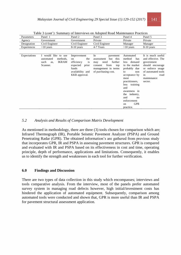
Table 3: Summary of Interviews on Adopted Road Maintenance Practices
Parameters Panel 1 Panel 2 Panel 3 Panel 4 Panel 5
Agency Government Government Private Private Private
Designation Civil Engineer Civil Engineer Civil Engineer Manager Manager
Experiences >10 years 8-10 years 4-7 Years >10 years 8-10 years
Types of road
maintenance
practices
Traditional Method
(Human Observation)
Traditional
Method
(Human Observation)
Traditional Method
(Human Observation)
Automated
Method
(200Mhz,400Mhz and
1.6GHz GPR)
Automated
Method
(FWD and Road Scanner)
Types of
information collect for
pavement maintenance
Functional distresses,
structural deformation, and road furniture.
Functional
distresses, structural
deformation, frictional
resistance (upon
demand) and road furniture.
Functional distresses
and structural deformations.
Functional
distresses and structural
deformations
Frictional,
Functional Distress,
Structural Deformation,
Strength and etc.

140 Malaysian Journal of Civil Engineering 29 Special Issue (1):129-152 (2017)
Table 3 (cont’): Summary of Interviews on Adopted Road Maintenance Practices
Parameters Panel 1 Panel 2 Panel 3 Panel 4 Panel 5
Agency Government Government Private Private Private
Designation Civil Engineer Civil Engineer Civil Engineer Manager Manager
Experiences >10 years 8-10 years 4-7 Years >10 years 8-10 years
Reason for
adopting the
method
Low cost though this
method consumes
greater time.
Substantial
costs are needed
in order to apply current
technologies
available.
Low cost and
practically been used
over a period of time.
Faster in data
acquisition
and flexibility in numerous
application.
Fast and cost
saving for long
term run. Can perform at high
speed, repeatable
and non destructive,
accurate and
reliable.
Time and
Cost
effectiveness towards
current
practice
The current practice
consumes lots of time
but maintain at low cost.
This practice is
time
consuming. It is very cost
subjective
because depends on the
schedule of rate,
additional works and
budgeted funds.
Costs saving because
of labor cost. Very
high time consuming. Improper time
management can lead
to outstanding number of roads not surveyed.
This method
is well
dependable, faster, save
time and
beneficial for long term cost
saving,
specially, in labors costs.
This method is
effective with
time consumption that reduces
human effort to
generate information,
assists in better
decision making and treatment
prioritizing.
Advantages of current
adopted
method
Bad roads been tackled accordingly
within the budget but
some remains
unattended due to
limited funds or
incapability to extend additional funds.
Huge improvement
made in road
line marking
requirements
for luminosity
specification and work
operation.
Has slightly improved in detection of
potholes and drainage
problem, and
improving in time
response issue.
It can arrest insufficient
work quality
especially in
overlay
thickness
problems, for example in
sinkhole.
The advancement of technology
does not require
substantial
improvement
except to maintain
the integrity of the current tools and
techniques used.
Drawbacks of
current method
adopted
Insignificant but there
are small percentage of discrepancies of
information that
affected the survey.
It has
deficiencies especially in
road structures
like culvert.
Mostly related to
drainage problems; overgrowth or
malfunction. For
problematic roads which reoccurring
potholes.
No No
Factors that
contribute to
the mentioned
problems
Human error Human error
and attitude.
Human error, under
motivated workers,
difference and lack of
technical knowledge,
less awareness, less
sense of ownership and exhaustion.
No No
Comparison
between Traditional
Method and
Automated Method
It is more accurate and
highly repeatable that will assists greatly in
reasonable decision
making and prioritization of work.
There are
discrepancies or inconsistencies
of information
generates through human
observation.
It is more accurate,
reliable, and faster at higher cost.
The
automated method is
faster and
adopt latest technology.
Inconsistent and
slow but this method is more
preferable in the
industry, save time, more
information given,
non destructive, reliable and
highly repeatable.
Mu
slim N
H et a
l.
Malaysian Journal of Civil Engineering 29 Special Issue (1):129-152 (2017) 141
Table 3 (cont’): Summary of Interviews on Adopted Road Maintenance Practices Parameters Panel 1 Panel 2 Panel 3 Panel 4 Panel 5
Agency Government Government Private Private Private
Designation Civil Engineer Civil Engineer Civil Engineer Manager Manager
Experiences >10 years 8-10 years 4-7 Years >10 years 8-10 years
Expectations I would like to use
automated methods,
such as, IKRAM Scanner.
Improvement
on the
efficiency is expected prior
funds
availability and KKR approval.
In pavement
assessment but this
may need further consent from top
management in terms
of purchasing cost.
Automated
method has
less demand in the market
probably due
to non acceptance by
most
practitioners, less training
and
awareness in the industry,
and no
enforcement on GPR
practice.
It is much useful
and effective. The
government should encourage
or enforce usage
of automated tools in road
maintenance
sector.
5.2 Analysis and Results of Comparison Matrix Development
As mentioned in methodology, there are three (3) tools chosen for comparison which are;
Infrared Thermograph (IR), Portable Seismic Pavement Analyzer (PSPA) and Ground
Penetrating Radar (GPR). The obtained information’s are gathered from previous study
that incorporates GPR, IR and PSPA in assessing pavement structures. GPR is compared
and evaluated with IR and PSPA based on its effectiveness in cost and time, operating
principle, depth of performance, applications and limitations. Consequently, it enables
us to identify the strength and weaknesses in each tool for further verification.
6.0 Findings and Discussion
There are two types of data collection in this study which encompasses; interviews and
tools comparative analysis. From the interview, most of the panels prefer automated
survey system in managing road defects however, high initial/investment costs has
hindered the application of automated equipment. Subsequently, comparison among
automated tools were conducted and shown that, GPR is more useful than IR and PSPA
for pavement structural assessment application.

142 Malaysian Journal of Civil Engineering 29 Special Issue (1):129-152 (2017)
6.1 Interviews Analysis Findings
Based on interviews conducted, it is concluded that automated method has long term
benefits compared to the traditional method as discussed below. It is obvious that
several comments made by expert panels are likely reflect the dissatisfaction level of
users, issues of discrepancies in information, insufficient funds to adopt high technology
tools, cost saving and time efficiency, work prioritizing, and to overcome workmanship
issue (see Table 4).
i. Satisfaction Level
Traditional method is a tedious work process from surveillance to corrective action.
There are many issues that related to dissatisfaction for example, in terms of information
discrepancies, slow progress, double handling work, exhaustion and human error.
Information discrepancy becomes a major concern because most of the ground
personnel that carried out surveillance were not expert and has lack of technical
understanding about road structures. Furthermore, different interpretations over similar
problems significantly lead to data inconsistencies in road surveillance work. In addition,
it will cause indecisiveness in decision making.
ii. Pavement Management
All agencies had set up unique road management system to address any pavement
distress issues arise. The tremendous improvement made by these agencies shows the
advancement of Malaysian road management system compare to many years ago. The
main role of the system is to undertake all road deficiencies that occur within their
responsibilities, scope of work and allocated funds. The tendency for the system to be
less reliable for traditional application is likely high because all information is generated
by human. Some agencies have taken initiative to arrest significant drawbacks of this
method by reviewing their policies, standard of procedures and operation however, with
too much reliance on human observation, the improvements probably become
ineffective in a longer period of time. The panels have stated effective pre and post
construction evaluation of applying automated tools.
iii. Cost – Time Effectiveness
Automated method is costly but improved whole work flows and contrarily, traditional
method is cheap but very slow. Automated method is very effective in cost saving
compare to traditional method because we need to account for tools purchasing costs in
earlier time only. Furthermore, it can provide extensive information at one time compare
to traditional method which needs several tests to be conducted just to get the same
amount of information or maybe less than what automated tools can provide. Moreover,
the cost of hiring labors can be reduced without affecting the productivity of
surveillance process.

Malaysian Journal of Civil Engineering 29 Special Issue (1):129-152 (2017) 143
iv. Planning and Prioritization
Traditional method is less effective in decision making due to limitation in knowledge
of the defects. Visual inspections is limited to identification of road surface condition
and restrained information for subsurface conditions which might be subjected to any
structural problem like; settlement. There is an issue happens where some roads may
look good physically but actually not. Thus, with the ability of automated tool to provide
information will help to assist managers for in work prioritization and planning for
resources, budget and time.
v. Information Discrepancy
Traditional method has higher intensity of information discrepancies rather than
automated method. There are several possible factors aggravate the situations such as;
lack of technical knowledge, human error, work attitude, lack sense of ownership,
natural flaws of human, and etc. This is a crucial issues that should be accounted and
overcome because the management of work is depends on the information retrieved
from site.
6.2 Tools Comparisons Matrix Analysis
Table 5 to Table 8 present the comparative analysis results between tools prior selection
in pavement structural assessment application. Comparative analysis between tools were
done thoroughly based on effectiveness in cost and time, operating principle, depth of
performance, applications and limitations. Reasonable arguments on tools selections are
provided accordingly.
Table 4: Expert panels’ rating analysis on the tool selection parameters
Parameter Expert panels’ Rating Average
Rating (%)
i. Satisfaction Level / / 40%
ii. Pavement Management / / 40%
iii. Cost –
Time
Effectiveness
Practice as highly time-consuming
but maintained at low cost.
/ / / 60%
Practice as faster and cost-saving. / / 40%
iv. Planning
and
Prioritization
Practices are continuous improving / / /
Practices are effective in advances
planning and identify obstacles
/ / 40%
v. Information Discrepancy / / / 60%

144 Malaysian Journal of Civil Engineering 29 Special Issue (1):129-152 (2017)
6.2.1. Cost-Time Effectiveness
From the literature analysis between tools as shown in Table 5, GPR shows the highest
time-cost effectiveness factor compared to IR and PSPA. Most of the study stated that
GPR can accommodate effectively in data acquisition, work execution and image
processing but some state that GPR is least effective in image interpretation phase.
Meanwhile, IR and PSPA are concluded to be easier in data acquisition stage only
because it can perform in less than a minute compare to GPR. However, GPR is found
to be more flexible with its ability to accommodate wide-ranging information in
pavement assessment studies rather than IR and PSPA. Thus, GPR is more considerable
to be assessed in this study with respect to its benefit in pavement application at a
reasonable time and cost.
6.2.2. Operating Principle
The selected tools shared two features in common which can be performed none
destructively at higher repeatability and operates based on the principle of
electromagnetic waves. These tools have different penetration depth into medium or
materials with respect to the wave frequency in used. The different in wave frequency
resulted in variation of penetration depth. For example GPR travel at lower frequency
than IR thus, level of performance when using GPR is greater which allows for
subsurface exploration rather than looking at the surface layers only. Similarly, PSPA
has the same performance level with IR therefore; both are more applicable and useful
for surface exploration. Obviously, GPR is more considerable to be assessed in this
study with respect to its benefit in pavement assessment at a greater depth of penetration
when compare to IR and PSPA (see Table 6).

Malaysian Journal of Civil Engineering 29 Special Issue (1):129-152 (2017) 145
Table 5: Comparative Analysis Between Tools in Effectiveness in Cost and Time
Tools Author (Year) Cost Time
GPR Bala, Garg & Jai (1996)
Saarenkato & Scullion (2000)
Qadi et al. (2003)
Benedetto & Pensa (2007)
Anderson (2003)
Maser (2006)
MDOT (2006)
Infrasense (2009)
Benedetto & Rosaria (2010)
Plati & Loizos (2012)
Wong (2012)
Bala, Garg, & Jai (2012)
Effective
Effective
Effective
Effective
Effective
Effective
Effective
Effective
Effective
Effective
Effective
Effective
Effective
Effective
Effective
Effective
Effective
Effective
IR Maldague (1993)
Prakash (2008)
Marchetti et al. (2010)
Mostafa (2013)
Schmitt et al. (2013)
Effective Effective
Effective
Least
Effective
Effective
Effective
PSPA Nazarian et al. (1993)
Yuan et al. (1999)
Bell (2006)
Daniel (2007)
Schmitt et al. (2013)
Effective
Effective
Effective
Effective
Effective
Effective
Effective
Table 6: Comparative Analysis Between Tools in Operating Principles
Tools Author (Year) Operating principle
GPR Saarenkato (2006)
Plati & Loizos (2007)
Qadi, Jiang & Lahour (2006)
Plati & Loizos (2007)
Schmitt et al. (2013)
Discrete pulse of energy
Discrete pulse of energy
Transmit and receive signals
Radio waves
Electromaganetic waves
IR Meegoda et al. (2002)
Stimolo et al. (2003)
Schimitt et al. (2013)
Thermal flow disturbance
Heat radiation emitted
Rate of heat and emissivity
PSPA Yuan et al. (1999)
Bell (2006)
Daniel (2007)
Schmitt et al. (2013)
Low frequency and high frequency
vibration
Ultrasonic waves
Stress waves
Ultrasonic waves

146 Malaysian Journal of Civil Engineering 29 Special Issue (1):129-152 (2017)
6.2.3. Depth of Performance
The sketch below shows a typical pavement cross section for GPR, IR and PSPA. It is
proven that GPR can penetrate at greater depth compare to IR and PSPA. GPR can
penetrate up to sub grade layer (layer V) while IR and PSPA minimally penetrate within
the surface course (layer I). For pavement structural assessment purposes, it requires
tool that can perform at greater penetration in order to show surface and subsurface
condition within pavement layers. Thus, the best tool to be adopted in this study is GPR
due to its sufficiency to penetrate all layers as shown in Figure 2.
Figure 2: Comparative Analysis between Tools in Depth of Performance
6.2.4 Applications
There are numerous advantages of using GPR, IR and PSPA in assessing pavement
structures as tabulated below. GPR has more flexibility in application compare to IR and
PSPA therefore, it is vital to choose GPR for pavement assessment in this study
(seeTable 7).
Layer I
Layer II
Layer III
Layer IV
Layer V
GPR PSPA IR

Malaysian Journal of Civil Engineering 29 Special Issue (1):129-152 (2017) 147
Table 7: Comparative Analysis Between Tools in Variety of Applications
Variety of Applications GPR IR PSPA
Determine pavement thickness layer / /
Detection of moisture ingress and voids / /
Identification of surface defects and patched zones / / /
Identify subsurface issue like settlement, dislodged culverts /
Segregation of aggregate / /
Detection of underground utilities /
Identification of damage layers and sinking problems /
Bridge structural assessment / / /
Concrete structural assessment / /
Culvert structural assessment /
Assists in quality control aspect / /
6.2.5. Limitations
The final parameter evaluated is tools limitations as shown in Table 8. All tools are
compared accordingly and suitability of tool is chosen not only based on its limitations
in practice but in consideration of other four (4) parameters adopted in this study.
Conclusively, GPR is selected for further evaluation in this study with respect to its
availability, performance, and applications. Nevertheless, specific precaution steps will
be taken to address the GPR limitations in application and operation.
Table 8: Comparative Analysis Between Tools in Limitations
Limitations GPR IR PSPA
Sensitive to wet surface or layers /
Noises or backscattered signal /
Environmental conditions exposure / / /
Sufficient conductivity of materials required /
Unable to distinguish gradation and segregation /
High temperature gradient is required /
Complexity of work process /
In comparing automated method and traditional method, it seems that automated method
is more efficient in work process because all site information are generated by
automated tools and analyzed by computer software. Traditional method has conquered
the road maintenance industry for years and it is a challenging process to change the
custom of maintenance method in the industry. In consideration of automated tools
capability compared to human efforts, the probability of misleading information is
manageable and adequately prevents work repetition. This situation is far efficient than
traditional ways thus, it is high time for the Government to revise the policy and
incorporate advanced tools and technology into road maintenance practice.

148 Malaysian Journal of Civil Engineering 29 Special Issue (1):129-152 (2017)
7.0 Conclusion
This study was initiated based on several issues and problems occur within the scope of
road maintenance practice. Several objectives were list out accordingly in this study to
assist in data collection and to ease in study flows. The first objective is to investigate
the current pavement maintenance management practice. There are two types of
maintenance method practiced in the industry such as traditional method and automated
method. Traditional method defines as manual observation using human while
automated method uses other than human effort like machines, tools and etc. to generate
information on site. Five (5) expert panels were interviewed in this study came from
different backgrounds, experience and years of service.
There are three (3) different tools compared in this study. The purposes of comparison
between tools are to identify the most feasible and effective tool to be incorporate in
pavement structural assessment for road maintenance. These tools namely are; Ground
Penetrating Radar, Infrared Thermograph, and Portable Seismic Pavement Analyzer.
Tools were compared according to the outlined research parameters in this study.
Through the comparative study, GPR is proved to be useful in providing extensive
information which in normal practice required for multiple testing on site. In contrast,
IR and PSPA are evaluated as less suitable for pavement structural assessment purpose.
Acknowledgement
The authors would like to thank the MOSTI grant vote no. R.J130000.7922.4S123,
FRGS vote no. R.J130000.7822.4F762, GUP grants vote no. Q.J130000.2609.11J04 and
Q.J130000.2609.10J8. Also, the authors appreciate these organizations for their supports
and contributions, and Research Management Center at Universiti Teknologi Malaysia.
References Advance Pavement Technologies (2008). Eight Rules for Preserving Your Asphalt
Investment. Advanced Pavement Technologies.
Amir et al (2012). Assessing the Benefits of Ground Penetrating Radar Technology – Does it
Improve the Accuracy of FWD Results and Overlay Design. Advances in Pavement
Evaluation and Instrumentation Session. Conference of the Transportationof Canada
Frederiction, New Brunswick.
Anderson (2003) A Generalized Protocol of Selecting Appropriate Geophysical Techniques.
Geophysical Technologies for Detecting Underground Coal Mine Voids; An Interactive
Forum. U.S Department of Transportation. Retrieved from website
http://www.fhwa.dot.gov/engineering/geotech/hazards/mine/workshops/ktwkshp/ky0307.cf
m on 20th November 2013.
Bala, Garg & Jai (2012). GPR Based Detection of Structurally Weak Zones of Road Pavement.
2012 International Conference on Traffic and Transportation Engineering (ICTTE 2012)
IPCSIT vol.26 (2012).

Malaysian Journal of Civil Engineering 29 Special Issue (1):129-152 (2017) 149
Bell (2006). Operating Portable Seismic Pavement Analyzer. Final Report. Geotechnical and
Structures Laboratory, Engineer Research and Development Centre, ERDC/GSL SR-06-9
Benedetto &Pensa (2007). Indirect Diagnosis of Pavement Structural Damage using Surface
GPR Reflection Techniques. Journal of Applied Geophysics 62 (2007) (107 – 133).
Bernama (2010). 10 MP: RM2.8 billion for improving urban public transport, Bernama Oct 15
2010, www.bernama.com.
Benedetto & Rosaria (2010). Applications of Ground Penetrating radar to Road Pavement: State
of Art and Novelties. GeoShanghai 2010 International Conference. Geotechnical Special
Publications No.203.
Benson (2003). An Overview of Geophysical and Non Destructive Methods for Characterization
of Roads and Bridges. Use of Geophysical Methods in Construction. Retrieved from
website http://ascelibrary.org/doi/pdf/10.1061/40521%28296%291 on 15th November 2013.
Bojan, Josipa &Tatjana (2012). Application of Infrared Camera for Quality Control during
Paving. 2nd
International Conference on Road and Rail Infrastructure. CETRA 2012.
Carl (2006). Personal communications, WaveTech Consulting, May 2006.
Central Federal Highway Division (CFL) (2013), Baseline Condition Assessment Using
Geophysical Methods. Federal Land Highway Programs. Retrieved from website
http://www.cflhd.gov/resources/agm/engApplication/BridgeSystemSuperstructure/331Basel
ineConditionAssessUsingGeophyMethods.cfm
Daniel (2007). Portable Seismic Analyzer – PSPA. 498 – Experimental Methods. University of
Illinois.
Dashevsky et al. (2005). Capacitance Sounding; A New Geophysical Method for Asphalt
Pavement Quality Evaluation. Journal of Applied Geophysics 57 (2005), 95-106.
Retrieved from website http://www.ac.els-cdn.com_S0926985104000849_1-s2.0-
S0926985104000849-main on 15th November 2013.
David (2012). Use of Ground Penetrating Radar (GPR) for Pavement Assessment and Evaluation.
TTE 5837 Pavement Management. University of Florida.
Doll W. E. (2008). The Path Behind and Highway Ahead: A Perspective on the Future of
Geophysics in Engineering. Geo Congress 2008.
Dumoulin et al. (2009). Active Infrared Thermography Applied to detection and Characterization
of Non Emergent Defects on Asphalt Pavement. NDTCE Conference, Nantes, 30th
– 3rd
July.
Gardiner, Law & Nesmith (2000). Using Infrared Thermography to Detect and Measure
Segregation in Hot Mix Asphalt Pavements., International Journal of Pavement Engineering,
1:4, 265-284, DOI:10.1080/10298430008901710. Retrieved from website
http://www.tandfonline.com/doi/pdf/10.1080/10298430008901710 on 3rd December 2013.
Gardiner and Brown (2000). Segregation in Hot-Mix Asphalt Pavements, NCHRP Report 441,
Transportation Research Board, National Research Council, Washington, D.C.
Georgopoulus, Loizos, & Flouda (1995). Digital Image Processing as a Tool for Pavement
Distress Evaluation. ISPRS Journal of Photogrammetry and Remote Sensing 50 (1): 23 – 33.
Grote et al. (2005). Evaluation of Infiltration in Layered Pavements Using Surface GPR
Reflections Techniques. Journal of Applied geophysics. 57 (2), 129 – 153.
Hartman, Baston, Sedgwick, and Bohmer (2004). Pilot Study Assessing the Feasibility of
Advanced Ground Penetrating Radar in Pavement Assessment. Bulletin 034. 8th
Conference on Asphalt Pavements for Southern Africa (CAPSA’ 04).
Hausman et al. (2002).Laboratory and Field Analysis of the TransTech Model 300 Pavement
Quality Indicator TM for Determining Asphalt Pavement Density. 81st Transportation
Research Annual Meeting, Washington, D. C.. Paper No. 02-4055. 2002.

150 Malaysian Journal of Civil Engineering 29 Special Issue (1):129-152 (2017)
Henault (1999). Development of Guidelines for Reduction of Temperature Differential Damage
(TDD) for Hot Mix Asphalt Pavement Projects in Connecticut, Report 2222-1-99-5,
Connecticut Department of Transportation.
Holzschuher et al. (2007), Accuracy and Repeatability of Ground Penetrating Radar for Surface
Layer Thickness Estimation of Florida Roadways, Research Report, Department of
Transportation Florida, State Materials Office, 07-505.
Ircon (n.p). Introduction to Infrared Thermometry, Technical Solution TS104, Retrieved from
website http://www.ircon.com/techsolution.html#5.
Krapez and Cielo (1991). Thermograph No Destructive Evaluation: Data Inversion Procedures,
Part 1: 1-D Analysis and experimental results, Res. Nondestructive Evaluation 3(2): 8 1-100.
Loizos and Plati (2007). Accuracy of Pavement Thickness Estimation Using Different GPR
Analaysis Approaches, NDT & E International 40, Amsterdam, Elsevier 2007, 147 – 157.
Mahoney et al. (2003). Application of Infrared Thermographic Imaging to Bituminous Concrete
Pavements – Final Report, Connecticut Advanced Pavement Laboratory, Connecticut
Transportation Institute, 2229-F-03-7
MALA GPR (2013). MAA GPR for Infrastructure and Construction Applications. MALA
Geosciences. Retrieved from website www.malags.com/solutions/roads on 2nd October
2013.
Maldague (1993). Nondestructive Evaluation of Materials by Infrared Thermography, Springer-
Verlag London Lirnited.
Marchetti et al. (2010). Implementation of and Infrared Camera for Road thermal
Mapping. 10th
International Conference on Quantitative Infrared Thermography, July 27 –
30, 2010 Quebec, Cananda.
Marc (2007). Using Ground Penetrating radar to Evaluate Minnesota Roads, Final Report,
Minnesota Department of Transportation, Research Service Section, Minnesota.
Mark & Dave (2006). Using Ground Penetrating Radar as an Assessment Methodology in
Roadway Rehabilitation. Soil and Materials Sessions. 2006 Annual Conference of the
Transportation Association of Canada.
Maser &Vandre (2006). Network level Pavement Structure Assessment Using Automated
Processing of Ground Penetrating Radar (GPR) Data. Airfield and Highway Pavements
2006.
MDOT (2006). Mississippi Department of Transportation State Study Phase I – GPR Final
Report.
Meegoda et al. (2006), Correlation of Surface Texture, Segregation and Measurements of Air
Voids, Final Report, New Jersey Department of Transportation, FHWA-NJ-2002-026.
Morcous & Erdogmus (2009). Use of Ground Penetrating Radar for Construction Quality
Assurance of Concrete Pavement. NDOR Project Number P307. Nebraska Department of
Roads & University of Nebraska, Lincoln.
Mooney, M. A., Miller, G. A., Teh, S. Y., & Bong, W. (2000). Importance of invasive measures
in assessment of existing pavements. Journal of Performance of Constructed
Facilities, 14(4), 149-154.
Mostafa (2013). Use of Infrared Thermography to Control the Quality of Joints Construction and
to Detect Reflective Cracking in Asphalt Pavements. Transportation Infrastructure State of
Good Repair. Retrieved from website http://www.evaccenter.lsu.edu/pub/13-04.pdf on 3rd
December 2013.
Morris (1991). Digital Design, 2e edition.
MTAG (2003). Common Flexible Pavement Distress. Caltrans Department of
Transportation. Maintenance

Malaysian Journal of Civil Engineering 29 Special Issue (1):129-152 (2017) 151
Technical and Advisory Guides July 2003. Retrieved from website
http://www.dot.ca.gov/hq/maint/MTAG-CommonFlexiblePavementDistresses.pdf on 3rd
December 2013.
Muller (2009). Application of Ground Penetrating radar to Road Pavement Rehabilitation.
Institute of Public Works Engineering Australia Queensland State Conference. Queensland
Road Edition No.7 March 2009.
NAPA, F. (2001). HMA Pavement Mix Type Selection Guide.
Nazarian et al. (2004). Implementation of Data Fusion techniques in Nondestructive Testing Of
Pavements. Technical Report, Centre of Transportation Information System, Texas
Department of Transportation, FHWA/TX-05/0-4393-2.
Oh, H. (1998). Image processing technique in automated pavement evaluation system.
Plati & Loizos (2012). Using Ground Penetrating Radar for Assessing the Structural Needs of
Asphalt Pavements. Non Destructive Testing and Evaluation Vol. 27, No.3, September
2012, 273 – 284. Retrieved from website
http://dx.doi.org/10.1080/10589759.2012.695784 on 1st October 2013.
Plati, Georgouli and Loizos (2013). Review of NDT Assessment of Road Pavement Using GPR.
Nondestructive Testing of Materials and Structures. RILEM Bookseries 6.
Poikajarvi, Peisa&Narbro (2012). Geophysical Research Abstracts, Vol. 14 EGU2012-9233-1.
EGU General Assembly 2012.
Prakash Rao (2008). Infrared Thermography and Its Application in Civil Engineering. Indian
Concrete Journal. Retrieved from website
http://icjonline.com/views/POV_2008_05_41_D.S.%20Prakash%20Rao.pdf on 3rd
December 2013.
Qadi, Jiang & Lahour (2006). Analysis Tools for Determining Flexible Pavement Layer
Thickness at Highway Speed. Proceedings of the Transportation research Board 85th
Annual
Meeting, Washington D.C.
Qadi, Lahouar, &Loulizi (2003). Successful Application of Ground Penetrating Radar for
Quality Assurance – Quality Control of New Pavements. Transport Research Record 1861
(2003) (86 – 97).
Ragnar (2008). Performance Indicator. Joint Nordic/Baltic Symposium on Pavement
Design and Performance Indicators. NVF 34 – Baltic Symposium 2008 – 02 -12.
VIANOVA.
Romero &Kuhnow (2002). Evaluation of New Non-Nuclear Pavement Density Gauges Using
Field Projects. 81st Transportation Research Annual Meeting, Washington, D. C.. Paper No.
02-2352. January 13-17, 2002.
Saarenkato (2006). Electrical Properties of Roads Materials and Subgrade Soils and The Uses of
Gound Penetrating radar In Traffic Infrastructure Surveys, PhD. Dissertations, Faculty of
Science, Department of Geoscience, University of Oulu.
Saarenketo & Scullion (1994). Ground Penetrating Radar Applications on Roads and
Highways. Research Report 1923 – 2F. Texas Transportation Institute, College Station, TX,
1994.
Saarenketo & Scullion (2000). Road Evaluation with Ground Penetrating Radar. Journal of
Applied Geophysics. 43(2 – 4) (2000) (119 -138).35. Saarenketo (2006). Electrical
Properties of Road Materials and Subgrade Soils and The use of Ground Penetrating Radar
in Tarffic Infrastructure Surveys, PhD. Dissertation., Faculty of Science, Department of
Geosciences, University of Oulu, 2006.
152 Malaysian Journal of Civil Engineering 29 Special Issue (1):129-152 (2017)
Saarenketo and Roimela (1998). Ground Penetrating Radar Techniques in Asphalt Pavement
Density Control, Proceedings of the Seventh International Conference on Ground
Penetrating Radar, May 27-30, Lawrence, Kansas, Vol 2, pp. 461-46.
Sandro, Danilo, & Marco (2011). Ground Penetrating Radar Assessment of Flexible Road
Pavement Degradation. International Journal of Geophysics. Hindawi Publishing
Corporation. Retrieved on website http://www.hindawi.com/journals/ijgp/2011/1989136
on 2nd October 2013.
Schmitt et al. (2013), Selection of Non-Destructive Testing Technologies for Asphalt Pavement
Construction, Airfiled and Highway Pavement 2013: Sustainable and Efficient Pavement,
ASCE Journal 2013, 573-584.
Sebastiano (2006). Evaluation of Pavement Surface Distress Using Digital Image
Collection and Analysis. Seventh International Congress on Advances in Civil Engineering
October 11 – 13, 2006. Yildiz Technical University, Istanbul, Turkey.
Shawn (2012). Advancement in GPR for Sustainable Tomorrow. Annual Conference &
Exhibition of the Transportation Association of Canada.
Smith & Scullion (1993). Development of Ground Penetrating Radar Equipment for
Detecting Pavement Condition for Preventive Maintenance. Technical Paper Project H 104
Strategic Highway research Program. Natural Resources Defense Council, Washington DC,
USA.
Steyn & Sadzik (2007). Application Of The Portable Pavement Seismic Analyser (Pspa) For
Pavement Analysis. Document Transformation Technologies. 26th Southern African
Transport Conference (SATC 2007) 1-920-01702-X Pretoria, South Africa.
Stimolo et al. (2003). Passive Infrared Thermography as Inspection and Observation Tool in
Bridge and Road Construction. International Symposium Non Destructive Testing in Civil
Engineering 2003. Retrieved from website
http://www.ndt.net/article/ndtce03/papers/v083/v083.htm on 15th November 2013.
Tahmoressi, Head, Saenz, & Rebala (1999) Material Transfer Device Showcase in El Paso,
Texas, Texas Department of Transportation, 1999.
Tsubokawa, Mizukami and Esaki (2007). Study on Infrared Thermographic Inspection of
Debonded Layer of Airport Flexible Pavement. National Institute for Land and
Infrastructure Management, FAA WORLDWIDE AIRPORT TECHNOLOGY TRANSFER
CONFERENCE Atlantic City, New Jersey, USA
U.S. Department of Transportation (2005). Geotechnical Exploration and Testing.
Geotechnical Aspects of Pavements and Reference Manual. U.S Department of
Transportation. Retrieved from website
http://www.fhwa.dot.gov/engineering/geotech/pubs/05037/04b.cfm on 15th November 2013.
Vera, Boriana & Christo (2008). Software Tool for GPR Data Simulation and Basic
Processing. Cybernetics and InformationTechnologies Volume 8, No 4. Bulgarian Academy
Of Sciences
Waheed (2006). Ground Penetrating Radar Study – Phase I Technology Review and Evaluation,
Mississippi Department of Transportation, FHWA/MS-DOT-RD-06-182.
Wong & Ernesto (2012). Ground Penetrating Radar (GPR) – A Tool for pavement Evaluation
and Design. 25th ARRB Conference – Shaping the Future; Linking Policy, research and
Outcomes, Perth, Australia 2012. ARRB Group Ltd and Authors.
Zaghloul et al. (2005). Implementation of a Reliability-Based Back calculation Analysis.”
Transportation Research Record 1905, Transportation Research Board, Washington, DC, pp.
97-106.