paudel and sakai
TRANSCRIPT

8/8/2019 Paudel and Sakai
http://slidepdf.com/reader/full/paudel-and-sakai 1/10
Bulletin of the Department of Geology, Tribhuvan University, Kathmandu, Nepal, Vol. 11, 2008, pp. 61–70
Stratigraphy and depositional environments of basin-fill sediments in
southern Kathmandu Valley, Central Nepal
*Mukunda Raj Paudel1 and Harutaka Sakai2
1 Department of Geology, Tribhuvan University, Tri-chandra Campus,Kathmandu, Nepal
2 Department of Geology and Mineralogy, Kyoto University, Kyoto 606-01, Japan
ABSTRACT
Quatenary fluvio-lacustrine basin-fill sediments in the southern part of the Kathmandu Basin was studied in order to clearify
the stratigraphy and reconstruct the sedimentary environment during the initial stage of the Paleo-Kathmandu Lake. Six stratigraphic
units; Tarebhir, Lukundol, Itaiti, Kalimati, Sunakothi Formations and Terrace gravel deposits, have been described based on field
observation of lithology and sediment distribution. The Tarebhir Formation is the basal unit which is overlained by alluvial fan of
the Itaiti Formation in the southern part and by the marginal lacustrine deposit of the Lukundol Formation towards the northern
part. Further 3 km toward the north from the basin margin at Jorkhu the the Lukundol Formation is overlain by the open lacustrine
facies of the Kalimati Formation. At the same locality the latter is overlain by fluvio-lacustrine facies of the Sunakothi Formation.
Moreover, the Terrace gravel deposits erosionally cover the Sunakothi Formation. The Kalimati Formation thickens northward,while the Sunakothi Formation thickens between the central and southern part of the basin. The study shows that the Sunakothi
Formation is of fluvio-lacustrine (fluvial, deltaic and shallow lacustrine) origin and extends continuously from the southern margin
(~1400m amsl) to the central part (~1300m amsl) of the basin. It also indicates that sediments of this formation were deposited at
the time of lake level rise and fall. Thick gravel sequence in the southern margin represents the alluvial fan before the origin (before
1 Ma) of the Paleo-Kathmandu Lake, while thick gravel sequence situated above the Sunakothi Formation is the Terrace gravel
deposits of the late Pleistocene age (14C method), deposited during and after the shrinkage of the Paleo-Kathmandu Lake from
south to north.
*Corresponding author:E-mail address: [email protected]
Bulletin of the Department of Geology
INTRODUCTION
Kathmandu Valley is located in the Lesser
Himalaya, and was an ancient lake named as Paleo-
Kathmandu Lake till 11 kyr B.P. (Sakai et al. 2001).
This basin is filled with very thick (up to 550m thick)
sequence of lacustrine and fluvial deposits of Plio-
Pleistocene age (Yoshida and Igarashi 1984,
Moribayashi and Mauro 1980). First, significant
works have been carried out by Yoshida and Igarashi
(1984), Yoshida and Gautam (1988), Dongol
(1985,1987), Sah et al. (1995), and Sakai (2001).
Yoshida and Igarashi (1984) first established
lithostratigraphic unit; the Lukundol Formation, whichwas the older lake sediments covered by three fluvial
terraces i.e. the Chapagaon, Boregaon and Pyangaon.
According to them, lake became narrow and shifted
toward the north due to upheaval of the Mahabharat
range. They proposed the units such as the Gokarna,
Thimi and Patan formations, which belonged to their
younger stage deposits. T. Sakai et al. (2001) reported
that these formations belonged to the fluvio-deltaic
deposits. Sah et al.(1995) proposed six stratigraphic
units for the whole basin-fill sediments, i.e. Tarebhir,
Lukundol, Sunakothi, Tokha, Kalimati and Thimi

8/8/2019 Paudel and Sakai
http://slidepdf.com/reader/full/paudel-and-sakai 2/10
62
M. R. Paudel and H. Sakai / Bulletin of the Department of Geology, Vol. 11, 2008, pp. 61–70
formations. Sakai (2001) proposed different
stratigraphic units in the south, central and northern
part of the basin. Paudel (2004), Paudel and Sakai
(2004 and 2006) explored lithological variation found
from south to north of the basin on the basis of
geological mapping including texture and composition
of the sediments. The redefinded stratigraphic names
are the Tarebhir, Lukundol, Itaiti, Kalimati, Sunakothi
formations and Terrace gravel deposits in ascending
order.
On the other hand, southernmost part of the basin,where oldest basin-fill sediments overlie the basement
rock with an angular unconformity, is the important
source of information regarding the history of the
early stage of the Paleo-Kathmandu Lake. Moreover,
in shallow and marginal lacustrine environments,
relatively small change in lake level can influence
on the depositional condition. In such areas, several
lithological changes can take place (Bustillo et al.
2002). In this paper, we mainly focused on distribution
of lithostratigraphic units in the southern marginal
part (Fig.1), their correlation with the previouslydefined stratigraphic units, and their depositional
environments.
LITHOSTRATIGRAPHY
The basin-fill sediments are broadly divided into
three sedimentary facies: the fluvio-deltaic facies
from north to center, fluvio-lacustrine facies from
south to center, and garavelly fan and fluvial facies
from southern margin of the basin (Sakai 2001).
Dongol (1985 and 1987) classified the valley-fill
sediments into older Lukundol Formation and younger
Kalimati Clay. Further, the Lukundol Formation was
divided into four members: the Tarebhir basal gravel
member, Kaseri-Nayankhandi lignite, Nakhu Khola
mudstone, and Champi-Itahari gravel in ascending
order. Gravel of the Tarebhir Formation was
interpreted to be originated from southern rim of the
basin. This gravel sequence represents fan deposits,
which are spreading from south to northand is covered
by 6 m thick conglomerate with pebbly sandstone
and cross-bedded sand. Clast consists of gneiss andmica schist, originated from the Shivapuri Gneiss to
the north. The present field study indicates that the
whole sequence of the Tarebhir Formation is not
alluvial fan deposits from south.
Yoshida and Igarashi (1984) proposed three
different terraces above the Lukundol Formation.
Similarly, Shrestha et al. (1999) showed the
Chapagaon Formation along the Nakhu Khola area.
Sawamura (2001) showed the Kalimati Formation
as the lateral facies change of the Itaiti and the
Lukundol formations. Therefore, different authorshave proposed differently the stratigraphic units of
the southern part of the basin. With geological
mapping, texture and composition of the sediments,
we conclude that Lukundol Formation is the fluvial
and marginal swamp facies, which is different from
the lacustrine facies of the Kalimati Formation that
extends upto the southern part of the basin, and
changes into the fluvio-lacustrine facies of the
Sunakothi Formation, and is also covered by the
Terrace gravel deposits.
The Itaiti Formation is restricted only in the
Fig. 1 Location map of the study area

8/8/2019 Paudel and Sakai
http://slidepdf.com/reader/full/paudel-and-sakai 3/10

8/8/2019 Paudel and Sakai
http://slidepdf.com/reader/full/paudel-and-sakai 4/10
64
M. R. Paudel and H. Sakai / Bulletin of the Department of Geology, Vol. 11, 2008, pp. 61–70
Fig. .3 Detailed columnar section of
the Tarebhir Formation at the type
loality Tarebhir in the southern margin
of the basin. Deatailed paleocurrent
direction and composition of the clasts
from bottom to top are shown on the
left diagrams
rounded in shape. These gravel beds are gently
inclined toward north (up to 9) at the southern
peripheries. The sequence overlies the Pre-Cambrian
rock of the Tistung Formation with an angular
unconformity (Fig. 5). Lithostratigraphic name of
the formation was introduced by Dongol (1985), andwas followed by Sah et al. (1994) and Sakai (2001).
The lower member of the Lukundol Formation of
Sakai (2001) is similar to the Tarebhir Formation of
this study. On the basis of the vertical and lateral
facies change, this formation is divided into three
parts: basal, middle and upper.
Basal part
Basal part of this formation consists of subrounded
boulder to pebble composed of metasandstone, phyllite
and granite (Fig. 5). Conglomerates are roughly
horizontal, and the sequence is about 30 m thick. The
basal part is distributed in Katuwaldaha, southern
end of the basin, and rests on the basement rocks of
the Kathmandu Valley (Fig. 6).
Middle part
The middle part of the Tarebhir Formation consists
of rounded to subrounded pebble and cobble of
tourmaline granite, metasandstone and phyllite.
Content of granite pebbles and their roundness increase
towards younger successions. More than 60% of the
clasts in this part is made up of tourmaline granite.
Sand and mud beds of 200- 600 mm thickness are
interbedded within thick gravel beds. The
conglomerate beds show planar and horizontal
stratification with imbrication of gravel. Thickness

8/8/2019 Paudel and Sakai
http://slidepdf.com/reader/full/paudel-and-sakai 5/10
65
Stratigraphy and depositional environments of basin-fill sediments in southern Kathmandu Valley, Central Nepal
of the middle part is about 60 m. Difference between
the basal part proposed by Dongol (1985) and the middle
part of this study lies on composition of the clasts.
Upper par t
The upper part of the Tarebhir Formation iscomposed of the pebbly gravel, micaceous cross-
bedded pebbly sand and mud beds. Increasing
proportion of sand and mud beds are the characteristic
features of this subunit. Beds are more or less
horizontal with imbrication of gravel. This subunit
is about 30 m thick. The uppermost part of the Tarebhir
Formation is directly overlained by the metasandstone
gravel sequence of the Itaiti Formation (Fig. 6) in
the southern margin, and by the muddy sequence of
the Lukundol Formation toward the center of the
basin (Fig. 6).
Lukundol Formation
Dhaundial (1966) first proposed the name of this
formation. Dongol (1985) considered the lower part
as the Kaseri-Naikhandi Lignite or lignite member
of the Lukundol Formation, the middle part as the
Nakhu Khola mudstone or silt member of the
Lukundol Formation, and the upper part as the
Champi-Itahari gravel of the upper gravel member
of the Lukundol Formation. Sakai (2001) considered
the Lukundol Formation of the present study, as the
middle part of the Lukundol Formation, and modified
the stratigraphic division in this area and gave the
name the Lukundol Formation to the southern part
of the basin. The formation conformably overlies the
Tarebhir Formation (near Danuwargaon) and is about
92 m thick, distributed in Lukundol, Naikhandi andKhahare (Fig. 2a). Repetition of the sand, silt, mud
lignite and carbonaceous mud are the main lithology
of this formation (Fig. 5). Dongol (1985) and Sah et
al. (1995) reported vertebrate and invertebrate fossils
from this formation. Such type of sequence can be
observed along the both banks of the Bagmati River
and its tributaries in Lukundol, Naikhandi and
upstream of the Nakhu Khola (Fig. 2a). On the basis
of the lithology, the Lukundol Formation is divided
into lower, middle and upper parts.
Lower part
The lower part of the Lukundol Formation is
exposed extensively along the Bagmati River, Khahare
and Dukuchhap. The thickness of this subunit is 27
m and is mainly composed of thick, cross-bedded,
coarse pebbly micaceous sand, bioturbeted silty sand,
silt, carbonaceous clay and lignite (Fig. 5). Dominant
lithology of this subunit is sand. Koirala et al. (1993)
and Sakai (2001) reported diamictites from this
formation.The most characteristic feature of this
subunit is alteration of the sand and carbonaceous
Fig. 4 Photographs of the Tarebhir
Formation: (a) Oldest basin-fill
sediments unconformably overlain on
the Precambriam basement rocks of the
Kathmandu Valley. Q: Quarzose
sandstone, BT: basal part of the Tarebhir
Formation (b) Gravelly Tarebir
Formation (T) is overlain by fluvial
swamp of Lukundol Formation (L), (c)
Gravelly Tarebhir Formation (T) isdirectly overlain by alluvial fan of the
Itaiti Formation (I); (d) Composition of
the clast of the Tarebhir Formation at
the middle part

8/8/2019 Paudel and Sakai
http://slidepdf.com/reader/full/paudel-and-sakai 6/10
66
M. R. Paudel and H. Sakai / Bulletin of the Department of Geology, Vol. 11, 2008, pp. 61–70
mud beds.
Middle partThe middle part is composed of fine silty sand,
fine sand with black mud and lignite. The succession
contains wavy cross-laminated and ripple-drift cross-
laminated sand and coarse cross-bedded sand. The
topmost part of the subunit consists of thick lenticular
gravel beds. This subunit contains invertebrate and
vertebrate fossils as well as the plant leaves. The
main features are the small-scale sedimentary structure
(Fig. 5) and the lesser proportion of the coarse sand
than the lower part of the Lukundol Formation. The
thickness of this subunit is about 49 m.
Upper par t
The upper part of the Lukundol Formation consistsof fine-laminated silty sand, fine sand, carbonaceous
mud, lignite and diatomaceous bed. The characteristic
features of this subunit are thick bed of thinly
laminated silty sand, and laminated carbonaceous
mud with plant leaves, mollusca and opercula (Fig.
5). Thickness of this subunit is 16 m at Lukundol.
Itaiti FormationThis stratigraphic unit is only distributed in the
southern marginal part of the Kathmandu Valley. It
is comprised of thick bed of pebble-cobbleconglomerate, sand and mud. The gravel is composed
mainly of metasandstone, phyllite, and quartzite. The
maximum thickness of this formation is 190 m and
is mostly distributed in the elevated area. The name
of this formation was first proposed by Sakai (2001).
Sah et al. (1995) included this sequence within the
Lukundol Formation. Yoshida and Igarashi (1984)
explained this sequence within the Terrace gravel
deposits, while Dongol (1985) introduced the name
Champi-Itaiti gravel. Paudel (2004) suggested that
this sequence did not only cover the LukundolFormation but also covered the Tarebhir Formation
in the southern margin, and the Sunakothi Formation
toward the center, and suggested to separate this
gravelly sequence laterally into different units from
the southern margin and toward the basin center.
From the present study, this formation is redifined
for the unit distributed only in the southern marginal
part of the basin. Furthermore, this formation is
divided into the distal and proximal part (Fig.6) based
on gravel size and interbedding of the sand and mud
beds.
In the southern margin of the study area, the Itaiti
Formation consists of thick gravel beds with
interbedded sand and mud. Towards north from the
basin margin, thickness of this formation gradually
decreases. The thickest part is distributed around
Babupakha, which is about 190 m resting on the
basement rock of the Kathmandu Complex. The lower
part consists of large disorganized conglomerate.
Maximum size of gravel is about 0.8 m and with
wide size range and poor sorting, as is observed at
Fig. 5 Lithostratigraphy of the Lukundol Formation at the
Lukundol area. On the basis of different lithology it is divided
into lower to upper part

8/8/2019 Paudel and Sakai
http://slidepdf.com/reader/full/paudel-and-sakai 7/10
67
Stratigraphy and depositional environments of basin-fill sediments in southern Kathmandu Valley, Central Nepal
Babupakha. Sand and mud beds are occasionally
interbedded in between the conglomeratic sequences.
Beds are generally horizontal. The formation exhibits
unconformable contact with the basement rock in
Babupakha, and with the Lukundol Formation in
Dukuchhap and Pharping. In Katuwaldaha (southern
marging of the basin), the Itaiti Formation directly
overlies the Tarebhir Formation.
Kalimati Formation
The Kalimati Formation consists of massive to
very thin-laminated black and grey silt and mud,
parallel laminated very fine sand and diatomaceous
mud. Mud beds contain plant leaves, mollusca shells,
and opercula. Along the Nakhu Khola, the sequence
contains plant leaves and fish teeth. Beds are
horizontal in the center but are inclined 4 to 11°N in
the southern part. The same lithological sequence is
found in the center part of the basin. Dhoundial (1966)
first described this unit as the Kalimati Formation.
Dongol (1985 and 1987) considered as the Kalimati
Clay. Yoshida and Igarashi (1984) described it as
Patan Formation. Sah et al (1995) used the Kalimati
Formation for narrowly distributed clay within the
central part of the basin. Sakai (2001) mentioned
thick bed of the Kalimati Formation in the central
part of the Kathmandu Basin, which extends thinly
toward the southern part. The exposed thickness of
the formation in the southern part is 40 m. Boundary
between the overlying Sunakothi and the underlying
Kalimati formations in the southern part at Jorkhu
can be observed at the altitude 1365 amsl, while from
this location toward the center near the Manohara
River, the boundary between Sunakothi and Kalimati
formations exists at about 1300 m amsl. The horizontal
distance between these two locations is 5.5 km. From
Jorkhu to 2 km towards north, the boundary between
these two formations is located at the Nakhu Khola,
where the beds dip 11o N.
Fig. 6 (a) Lithofacies changes within the Itaiti Formation from proximal to distal part (b) Photograph showing cross-bedded fluvialgravel above the upper part of the Sunakothi Formation

8/8/2019 Paudel and Sakai
http://slidepdf.com/reader/full/paudel-and-sakai 8/10
68
M. R. Paudel and H. Sakai / Bulletin of the Department of Geology, Vol. 11, 2008, pp. 61–70
Sunakothi Formation
The type locality of the Sunakothi Formation is
designated at Sunakothi 3.0 km south from the Patan
(Paudel and Sakai 2005 and 2006). The name of this
unit is first proposed by Sah et al (1995). Sakai (2001)
suggested that it is a southern extension of the Thimi
Formation. Paudel (2004) and Paudel and Sakai (2004
and 2005) suggested that it is a different stratigraphic
unit than the Thimi and Lukundol formations. The
formation is composed of the alternating beds of mud
and sand at the basal part in the southern margin. The
formation is sandy, muddy and gravelly at the middle
part, and is sandy to silty at the upper part. Parallel
and climbing ripple laminations are developed in fine
sand. The outcrop is well exposed in Sunakothi, along
the Kyakudol Khola between Jorkhu and Parigaon.
The exposed thickness of this formation is about 34
to 60 m, and is distributed from 1420 m amsl in the
southern margin to nearly 1300 m amsl at central part
of the basin. The formation is underlain by the
Kalimati Formation and is overlain by the Terrace
gravel deposits. The boundary between the Kalimati
and Sunakothi formations is gradational to erosional.
Terrace gravel deposits
This unit is mainly composed of pebble-cobble
gravel. The organization of the clast is well showing
the layer of different sized gravel, and also interbedded
sand and mud beds. Horizontal layers show good
imbrication and also cross-bedded gravels and sand
are prominent (Fig. 6c).This conglomerate sequence
is often interbedded with very thin carbonaceous mud
and sand. Both fining and coarsening-upward
sequence is clearly observed within the outcrop.
Planar cross-bedded gravels show imbrication. In
some locality the conglomerate shows strong scouring
in the silty clay of the Sunakothi Formation. This
stratigraphic unit is well exposed in Chhampi and
Chapagaon Sunakothi and Thecho. At the central part
of the basin, a thick terrace gravel with metasandstone
and quartzite clasts erosionally covers the Sunakothi
and Kalimati formations.
One remarkable point about thick gravelly
sequence is, its contact relation between the different
formations. Previously whole gravel sequence was
considered as the alluvial fan by Sakai (2001). This
gravelly sequence overlie the Tarebhir, Lukundol and
Sunakothi formations from proximal to the distal
parts. The proximal part of the gravel is interpreted
as alluvial fan of the Itaiti Formation while toward
the basin center is the Terrace gravel deposits.
DISTRIBUTION AND CHANGES OF
STRATIGRAPHIC UNITS
In the southern marginal part of the basin, older
basin-fill sediments of the Tarebhir Formation is
directly overlain by the fan of the Itaiti Formation.
Imbrication of pebbles and composition of the detritus
of the Tarebhir and Itaiti formations indicate that the
source of the sediments changed at the time of
deposition of these stratigraphic units. Detritus of theTarebhir Formation were mostly from north and
small-scale sedimentation occurred from east and
west at the basal part. Detritus of the Itaiti Formation
were mostly from south and southeast (Fig. 6b).
Toward the north from the basin margin at
Danuwarganon marginal lacustrine facies of the
Lukundol Formation is located between the alluvial
fan and fluvial facies of the Itaiti and Tarebhir
formations. Composition of the detritus of the
Lukundol Formation showed that the main source
was from north. However, around the periphery of the basement rock, detritus was perhaps transported
from east, west and south.
About 3.0 km north from the basin margin, open
lacuastrine facies of the Kalimati Formation overlie
the marginal lacustrine facies of the Lukundol
Formation (Paudel 2004; Paudel and Sakai 2004).
Again, this open lacustrine facies of the Kalimati
Formation is covered by the fluvio-lacustrine facies
of the Sunakothi Formation. This Sunakothi Formation
from the Jorkhu (~3 km north from the basin margin)
is erosionally covered by the 2 m to more than 25 mthick terrace gravels. This sequence is continuing
from the south to the central part of the basin.
Paleocurrent and compositional data of the Sunakothi
sediments show southern sources.
DEPOSITIONAL ENVIRONMENTS
Four facies in the southern part of the Kathmandu
Basin are (a) fluvial facies of the Tarebhir and the
lower part of the Lukndol formation, (b) fluvial-
swamp facies of the middle and upper part of the
8/8/2019 Paudel and Sakai
http://slidepdf.com/reader/full/paudel-and-sakai 9/10
69
Stratigraphy and depositional environments of basin-fill sediments in southern Kathmandu Valley, Central Nepal
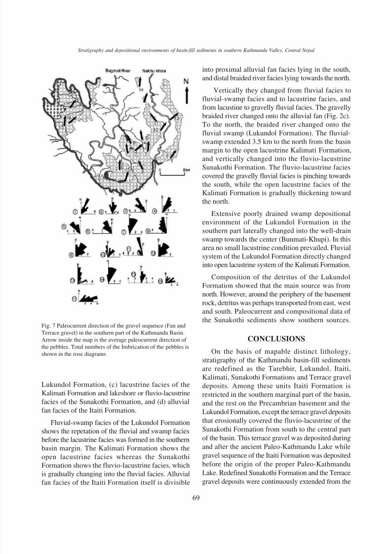
Fig. 7 Paleocurrent direction of the gravel sequence (Fan and
Terrace gravel) in the southern part of the Kathmandu Basin.
Arrow inside the map is the average paleocurrent direction of
the pebbles. Total numbers of the Imbrication of the pebbles is
shown in the rose diagrams
Lukundol Formation, (c) lacustrine facies of theKalimati Formation and lakeshore or fluvio-lacustrine
facies of the Sunakothi Formation, and (d) alluvial
fan facies of the Itaiti Formation.
Fluvial-swamp facies of the Lukundol Formation
shows the repetation of the fluvial and swamp facies
before the lacustrine facies was formed in the southern
basin margin. The Kalimati Formation shows the
open lacustrine facies whereas the Sunakothi
Formation shows the fluvio-lacustrine facies, which
is gradually changing into the fluvial facies. Alluvial
fan facies of the Itaiti Formation itself is divisible
into proximal alluvial fan facies lying in the south,
and distal braided river facies lying towards the north.
Vertically they changed from fluvial facies to
fluvial-swamp facies and to lacustrine facies, andfrom lacustine to gravelly fluvial facies. The gravelly
braided river changed onto the alluvial fan (Fig. 2c).
To the north, the braided river changed onto the
fluvial swamp (Lukundol Formation). The fluvial-
swamp extended 3.5 km to the north from the basin
margin to the open lacustrine Kalimati Formation,
and vertically changed into the fluvio-lacustrine
Sunakothi Formation. The fluvio-lacustrine facies
covered the gravelly fluvial facies is pinching towards
the south, while the open lacustrine facies of the
Kalimati Formation is gradually thickening towardthe north.
Extensive poorly drained swamp depositional
environment of the Lukundol Formation in the
southern part laterally changed into the well-drain
swamp towards the center (Bunmati-Khupi). In this
area no small lacustrine condition prevailed. Fluvial
system of the Lukundol Formation directly changed
into open lacustrine system of the Kalimati Formation.
Composition of the detritus of the Lukundol
Formation showed that the main source was from
north. However, around the periphery of the basement
rock, detritus was perhaps transported from east, west
and south. Paleocurrent and compositional data of
the Sunakothi sediments show southern sources.
CONCLUSIONS
On the basis of mapable distinct lithology,
stratigraphy of the Kathmandu basin-fill sediments
are redefined as the Tarebhir, Lukundol, Itaiti,
Kalimati, Sunakothi Formations and Terrace gravel
deposits. Among these units Itaiti Formation isrestricted in the southern marginal part of the basin,
and the rest on the Precambrian basement and the
Lukundol Formation, except the terrace gravel deposits
that erosionally covered the fluvio-lacustrine of the
Sunakothi Formation from south to the central part
of the basin. This terrace gravel was deposited during
and after the ancient Paleo-Kathmandu Lake while
gravel sequence of the Itaiti Formation was deposited
before the origin of the proper Paleo-Kathmandu
Lake. Redefined Sunakothi Formation and the Terrace
gravel deposits were continuously extended from the

8/8/2019 Paudel and Sakai
http://slidepdf.com/reader/full/paudel-and-sakai 10/10
70
M. R. Paudel and H. Sakai / Bulletin of the Department of Geology, Vol. 11, 2008, pp. 61–70
south to the central part of the basin, and were
deposited during the last stage of the Paleo-Kathmandu
Lake. All the detritus of these two units were
transported from the south of the Kathmandu Valley.
ACKNOWLEDGEMENT
The first author carried out this research as a part
of the M. Sc. course in the framework of
MONBUSHO in Kyushu University. We would like
to thank Hiroshi Nisi (Hokkaido University), and
Yoshihiro Kuwahara, Masao Ohno and Kiyotaki
Ishida (Kyushu University) for various cooperation.
We are grateful to Prof. B. N. Upreti, Dean Institute
of Science and Technology for providing suggestion.
We are thankful to the Director General and staff of
the Department of mines and Geology, Nepal for
cooperation to bring the samples to Kyushu University.
We also thank Satoshi Funakawa (Former JOCV in
Tribhuvan University, Nepal) for his help and support.
REFERENCES
Bustillo, M. M., Arribas. M. A., and Bustillo, M., 2002.
Dolomitizat ion and silicificat ion in low energy
lacustrine carbonate (Paleogenne, Madrid Basin, Spain),
Sedimentary Geology v. 151, pp. 107 - 126.
Dongol, G.M.S., 1985. Geology of the Kathmandu fluvio-
lacustrine sediments in the light of new vertebrate fossils
occurrences. Jour. Nepal Geol. Soc, v. 3, pp. 43- 47.
Dongol, G.M.S., 1987. The stratigraphic significance of
vertebrate fossils from the Quaternary deposits of the
Kathmandu Basin, Nepal. Newsl. Stratigraphy, v.18,
no.1, pp. 21- 29.
Dhoundial, E. P., 1966. Investigation of lignite deposits
in the Kathmandu Valley, Nepal. Unpub. G.S.I. report, 3p.
Koirala, A., Shrestha, O. M., and Karmacharya, R., 1993.
Engineering geology of the southern part of the
Kathmandu Valley. Jour. Nepal Geol. Soc., v.3 (Sp.
Issue), pp. 151- 159.Moribayashi, S. and Maruo, Y., 1980. Basement topography
of the Kathmandu Valley, Nepal-an application of the
gravitational method to the survey of a tectonic basin
in the Himalaya. Jour. Japan Soc. Engn. Geol., v. 21,
pp.30- 37.
Paudel, M. R., 2004. Depositional environmental changes
in the southern part of the Kathmandu Valley, Central
Nepal, M. S. dissertation submitted to Kyushu
University, Ropponmatsu Campus, Japan, 135p.
Paudel, M. R., and Sakai, H., 2004. Stratigraphy and
depositional environment of the basin-fill sediments in
the southern part of the Kathmandu Valley, central
Nepal, Abstract, the 111 Annual meeting of the
Geological Society of Japan, 308p.
Paudel, M.R. and Sakai, H., 2005. Depositional environment
and Stratigraphic position of the Sunakothi Formation,
in the southern part of the Kathmandu Valley, Central
Nepal. The 112th annual meeting of the Geol. Soc.
Japan, Kyoto, Japan, 39p.
Paudel, M.R, and Sakai, H., 2006. Late Pleistocene
depositional environmental changes in the draining
stage of the Paleo-Kathmandu Lake in the southernpart of the Kathmandu Basin, Central Nepal, ISC
Fukuoka 2006, pp.127- 127.
Sawamura, F., 2001. Sedimentary facies changes recorded
in the Plio-Pleistocene Kathmandu Basin Group in the
southern part of the Kathmandu valley, Nepal. Jour.
Nepal Geol. Soc., v.25 (Sp.Issue), pp.33 - 42 .
Sakai, T., Gajurel, A.P., Tabata, H., and Upreti B.N., 2001.
Small amplitude lake level fluctuations recorded in
aggrading delta deposits of the upper Pleistocene Thimi
and Gokarna formations , Kathmandu Valley, Nepal.
Jour. Nepal Geol. Soc., v 25 (Sp. Issue), pp. 43- 51.
Sakai, H., 2001. Stratigraphic division and sedimentaryfacies of the Kathmandu Basin sediments. Jour. Nepal
Geol. Soc., v. 25 (Sp. Issue), pp.19- 32.
Sah, R.B., Paudel, M., and Ghimire, D, 1995. Lithological
succession and some vertebrate fossils from the fluvio-
lacustrine sediments of Kathmandu Valley, Central
Nepal. NAHSON, v. 5, no. 6, pp. 21 - 27.
Shrestha, O.M., Koirala, A., Karmacharya, S.L.,
Pradhananga, U.B., Pradhan, R., and Karmacharya, R.,
1999. Engineering and environmental geological map
of the Kathmandu Valley (1:50,000). Dept. Mines and
Geology, HMG Nepal.
Yoshida, M and Igarashi, Y., 1984. Neogene to Quaternary
laustrine sediments in the Kathmandu Valley, Nepal.
Jour. Nepal Geol., Soc., v. 4 (Sp. Issue), pp. 73- 100.
Yoshida, M. and P. Gautam, 1988. Magnetostratigraphy
of Plio-Pleistocene lacustrine deposits in the Kathmandu
Valley, central Nepal. Proc. Indian national, science
academy, v. 54A, no. 3, pp. 410- 417.