patterns of arcticgeographygordon.weebly.com/uploads/2/7/1/4/... · north pole y e n i s e y r. a m...
TRANSCRIPT

Dnieper
R.
Ob
R.
Ob R.
IrtyshR
.
Volga R.
Ural R.
Don
R.
Am
uD
aryaR
.
Syr Darya
R.
Dniester
R.
N.D
v inaR
.
Tobo
l R.
Kama
R.
FranzJosefLand
Svalbard
Novaya Zemlya
ARCTICOCEAN
Barents Sea
North Sea
KaraSea
Sea of Azov
Cas
pian
Sea
B a l t i c SeaWhite Sea
Black
Sea
Gulf o
fO
b
LakeBalkhash
ZaysanLake
Lake Issyk Kul
LakeLadoga
LakeOnega
AralSea
KAZAKHSTAN
R U S S I A
TURKMENISTAN
UZBEKISTAN
ARMENIA
GEORGIA
UKRAINE
BELARUS
MOLDOVA
LITHUANIA LATVIARUSSIA
ESTONIA
AZERBAIJANAZER.
KYRGYZSTAN
TAJIKISTAN
FINLAND
SWEDEN
NORWAY
POLAND
TURKEY
I R A N
I R A Q
70°N60°N
30°N
80°N
50°N
40°N
20°E
10°E
10°W
40°E
30°E
0°
ArcticCircle
W E S T
S I B E R I A N
P L A I N
N O R T H E R N
E U R O P E A N
P L A I N
TuranPlain
Kazakh
Uplands
K i r g h i z S t e p p e
CAUCASUS
MTS.
UR
AL
MO
UN
TA
IN
S
PAMIRS
TIAN SHAN
Kyzyl Kum
Desert
Kara KumDesert
KolaPeninsula
Caspian DepressionMt. Elbrus18,510 ft.
(5,642 m.)
Mt. Narodnaya6,217 ft.(1,895 m.)
Communism Peak24,590 ft.(7,495 m.)
Patterns of Physical Geography
336 UNIT 5
Comparing Data
Lakes
Dep
th(f
eet)
World’s DeepestLake BaikalAsia (Russia)
5,715 feet
U.S. DeepestCrater Lake
North America1,932 feet
Caspian SeaEurope-Asia3,363 feet
Lake Issyk-KulAsia (Kyrgyzstan)
2,303 feet
6,0005,0004,0003,0002,0001,000
0
Russia and the Republicsspan two continents. Thepart of the region thatlies to the west of theUral Mountains is part of Europe. The part ofthe region that lies to the east of the Urals ispart of Asia.
Use the Unit Atlas toadd to your knowledge ofRussia and the Republics.As you study the mapsand charts, noticegeographic patterns and specific details about the region.
Jot down answers tothe following questionsin your notebook.
Making Comparisons1. What ocean lies to the
north of Russia and theRepublics? How mightthis ocean affect theregion’s climate?
2. How much deeper isLake Baikal than thedeepest lake in theUnited States?
3. Based on these maps andcharts, which region doyou think has the higherpopulation density: Russiaand the Republics or theUnited States? Why?
For updated statistics on Russia and the Republics . . .
DATA UPDATECLASSZONE .COM
336-340-Unit 5 Opener 10/16/02 10:57 AM Page 336

North Pole
YeniseyR.
Amur R.
Lena
R.
Kolym
aR.
Lena
R.
Angara R.
Ussuri R
.
IndigirkaR
.
Lower Tunguska R.
New SiberianIslands
WrangelIsland
SakhalinIsland
Ku
ri
lI
sl
an
ds
ARCTICOCEAN
PACIFICOCEAN
EastSiberian
Sea
Bering Sea
LaptevSea
Sea of Okhotsk
Sea ofJapan
ChukchiSea
LakeBaikal
R U S S I A
MONGOLIA
JAPAN
C H I N A
70°N 60°N80°N
30°N
50°N
40°N
20°N
130°E 140°E
150°E
160°E
170°E
180°
Arctic
Circ
le
Tropic of Cancer
C E N T R A L
S I B E R I A N
P L A T E A U
R U S S I A N
FA R E A S T
S I B E R I A
SAYAN MTS.
YABLO
NOVY
RAN
GE
VE
RKHOYANSK RANGE
STANOVOY RANGE
CHERSKIY RANGE
KO
LY
MA
MT
S.
KO
RY
AK
MTS.
KamchatkaPeninsula
ChukchiPeninsula
Elevation
Mountain peak
(4,000 m.)(2,000 m.)
(500 m.)(200 m.)
(0 m.)Below sea level
13,100 ft.6,600 ft.1,600 ft.
650 ft.0 ft.
0
0 250 500 kilometers
250 500 miles
Two–Point Equidistant Projection
N
SE
W
337
Russia and the Republics: Physical
RU
SS
IA &
REP
.
Russia and the Republics
8,600,340 sq mi
ContinentalUnited States
3,165,630 sq mi
Comparing Data
Landmass
Population
0 50 100 150 200 250 300
United States281,422,000
Russia and the Republics
289,730,000
Population (in millions)
336-340-Unit 5 Opener 10/16/02 10:57 AM Page 337

St. Petersburg
Samara
Yekaterinburg
Nizhniy Novgorod
Novosibirsk
Chelyabinsk
Almaty
Donets'k
Dnipropetrovs'k
Zaporizhzhya
KazanKharkiv
Murmansk
Odessa
Omsk
RostovVolgograd
SaratovUfa
L'viv
Perm
Semey
Voronezh
Chernobyl
Arkhangelsk
Bukhoro
Grozny
Samarqand
Izhevsk
Togliatti
Simbirsk
Krasnodar
Astrakhan
YaroslavlHomel'
Riga
Tallinn
Kiev
Chisinau˘¸
Minsk
Vilnius
Moscow
Yerevan
Tbilisi
Baku
Tashkent
Astana
Bishkek
Dushanbe
Ashgabat
Irtysh R.
Ob
R.
Volga R.
Dnieper
R.
Ob R.
Am
u Darya
R.
Syr Darya
R.
N.D
v inaR
.
Tobo
l R.
Kama
R.
Novaya Zemlya
FranzJosefLand
Svalbard(Nor.)
Cas
pian
Sea
Black
Sea
ARCTICOCEAN
Barents Sea
North Sea
Sea of Azov
B a l t i c SeaWhite Sea
Gulf o
fO
b
KaraSea
LakeBalkhash
ZaysanLake
LakeLadoga
LakeOnega
AralSea
KAZAKHSTAN
R U S S I A
TURKMENISTANUZBEKISTAN
ARMENIA
GEORGIA
UKRAINEBELARUS
MOLDOVA
LITHUANIA LATVIARUSSIA
ESTONIA
AZERBAIJANAZER.
KYRGYZSTANTAJIKISTAN
FINLAND
SWEDEN
NORWAY
POLAND
TURKEY
I R A N
AFGHANISTAN
PAKISTAN
INDIANEPAL
I R A Q
70°N60°N
30°N
80°N
50°N
40°N
20°N
20°E
10°E
10°W
40°E
30°E
60°E
50°E
80°E70°E
0°
ArcticCircle
Tropic of Cancer
Patterns of Human Geography
In 1991, the politicalgeography of Russia andthe Republics changeddramatically. Fordecades, the region’s 15 republics had beenpart of the Soviet Union.Each of the republicsbecame independentafter 1991, when theSoviet Union collapsed.
Study the map of theformer Soviet Unionand the map of Russiaand the Republics today.Then answer thesequestions in yournotebook.
Making Comparisons1. Where are most of the
region’s smaller republicslocated?
2. What was the largestrepublic in the SovietUnion? What is thelargest republic in theregion today?
3. To which of the SovietSocialist Republics didKaliningrad belong?
338 UNIT 5
336-340-Unit 5 Opener 10/16/02 10:57 AM Page 338

Irkutsk
Krasnoyarsk
Khabarovsk
Vladivostok
Yakutsk
Oymyakon Petropavlovsk-Kamchatski
Norilsk
Amur R.
Lena
R.
Lena
R.
Angara R.
IndigirkaR
.
YeniseyR.
Lower Tunguska R.
Kolym
aR.
SevernayaZemlya
New SiberianIslands
WrangelIsland
SakhalinIsland
Ku
ri
lI
sl
an
ds
ARCTICOCEAN
PACIFICOCEAN
EastSiberian
Sea
Bering Sea
LaptevSea
Sea of Okhotsk
Sea ofJapan
ChukchiSea
LakeBaikal
R U S S I A
MONGOLIA JAPANNORTHKOREA
C H I N A
70°N 60°N80°N
30°N
40°N
90°E
150°E
160°E
170°E
180°
Arctic
Circ
le
National capital
Other city
0
0 250 500 kilometers
250 500 miles
Two–Point Equidistant Projection
N
SE
W
North Pole
339
Russia and the Republics: Political
RU
SS
IA &
REP
.
ARCTIC OCEAN
PACIFICOCEAN
AralSea
BeringSea
Baltic Sea
Cas
pia
nSe
a
Sea of Okhotsk
Seaof
Japan
Black
Sea
LakeBaikal
LakeBalkhash
ARMENIANS.S.R.
AZERBAIJAN S.S.R.
TURKMENS.S.R.
BELORUSSIANS.S.R.
MOLDAVIANS.S.R.
RUSSIAN SOVIET FEDERATED SOCIALIST REPUBLIC(R.S.F.S.R.)
LATVIAN S.S.R.
LITHUANIANS.S.R.
KALININGRAD(R.S.F.S.R.)
ESTONIANS.S.R.
GEORGIANS.S.R.
UZBEKS.S.R.
KAZAKHS.S.R.
TADZHIK S.S.R.
KIRGHIZ S.S.R.
UKRAINIANS.S.R.
POLAND
FINLAND
SLOV.
ROMANIA
I R A N
TURKEY
MONGOLIA
C H I N A
JAPAN
S. KOREA
N. KOREA
60°N
0°
20°E
40°E 60°E 100°E 120°E
60°N 40°N80°N 80°N
Arct
icCi
rcle
0
0 500 1,000 kilometers
500 1,000 miles
Two-Point Equidistant Projection
N
SE
W
NOTE: S.S.R. is the abbreviationfor Soviet Socialist Republic
Former Soviet Union, 1989
336-340-Unit 5 Opener 10/16/02 10:57 AM Page 339
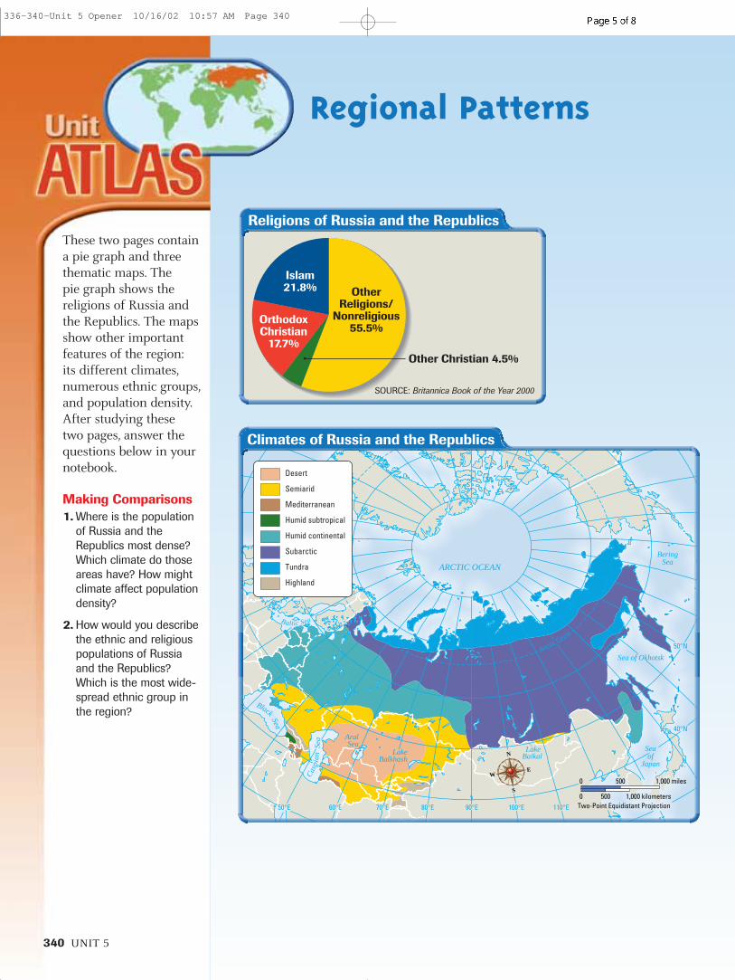
340 UNIT 5
Regional Patterns
These two pages containa pie graph and threethematic maps. The pie graph shows thereligions of Russia andthe Republics. The mapsshow other importantfeatures of the region: its different climates,numerous ethnic groups,and population density.After studying these two pages, answer thequestions below in yournotebook.
Making Comparisons1. Where is the population
of Russia and theRepublics most dense?Which climate do thoseareas have? How mightclimate affect populationdensity?
2. How would you describethe ethnic and religiouspopulations of Russiaand the Republics?Which is the most wide-spread ethnic group inthe region?
ARCTIC OCEAN
BeringSea
Baltic Sea
Cas
pian
Sea
Sea of Okhotsk
Seaof
Japan
Black
Sea
NorthSea
AralSea
LakeBalkhash
LakeBaikal
50°E 60°E 70°E 80°E 90°E 100°E 110°E
40°N
50°NArctic Circle
0
0 500 1,000 kilometers
500 1,000 miles
Two-Point Equidistant Projection
N
S
EW
Desert
Semiarid
Mediterranean
Humid subtropical
Humid continental
Subarctic
Tundra
Highland
Climates of Russia and the Republics
SOURCE: Britannica Book of the Year 2000
Religions of Russia and the Republics
Other Christian 4.5%
Islam21.8%
OrthodoxChristian
17.7%
OtherReligions/
Nonreligious55.5%
336-340-Unit 5 Opener 10/16/02 10:57 AM Page 340

ARMENIA
AZERBAIJAN
GEORGIA
BELARUS
ESTONIA
KAZAKHSTAN
KYRGYZSTAN
LITHUANIA
RUSSIA
LATVIA
MOLDOVA R U S S I A
TURKMENISTAN
TAJIKISTAN
UZBEKISTAN
UKRAINE
ARCTICOCEAN Bering
Sea
Baltic Sea
Cas
pia
nSe
a
Sea of Okhotsk
Black
Sea
60°E 80°E 100°E 120°E
140°E
160°E
180°
160°W
40°N
60°N
80°N
Arctic Circle
0
0 500 1,000 kilometers
500 1,000 miles
Two–Point Equidistant Projection
N
S
E
W
INDOEUROPEAN Slavic
Belarusian
Russian
Ukrainian
BalticLatvian
Lithuanian
URALIC Finish
Estonian
Karelian
Other Finnish
OTHERCaucasian
Mongolian
Sparsely populated
INDOEUROPEAN (con't.) Other
Armenian
Moldovan
Tajik
ALTAIC Turkish
Azerbaijani
Kazakh
Kyrgyz
Turkish
Uzbek
Yakut
Other Turkic
Moscow
Novosibirsk
Nizhniy Novgorod
St. Petersburg
Minsk
Vilnius
RigaTallinn
Kiev
Samara Yekaterinburg
BakuYerevan
Tbilisi
TashkentAshgabat
Chelyabinsk
Murmansk
Donets'k
Bishkek
Dushanbe
Irkutsk
KazanKharkiv
KrasnoyarskOmsk
Perm
Rostov
Ufa
Vladivostok
Almaty
Astana
Chisinau¸ ˘
ARCTIC OCEAN
AralSea
BeringSea
Baltic Sea
Cas
pian
Sea
Sea of Okhotsk
Seaof
Japan
Black
Sea
60°N80°N 80°N
40°N
140°E
160°E
180°
80°E60°E 100°E 120°E
Arct
icCi
rcle
0
0 500 1,000 kilometers
500 1,000 miles
Two–Point Equidistant Projection
N
S
E
W
Personsper
sq mi
Personspersq km
Over 520260–519130–25925–129
1–240
Over 200100–19950–9910–491–90
Ethnic Groups
Population Density
341
341-Unit 5 Opener 10/16/02 10:58 AM Page 341

Study the charts on thecountries of Russia andthe Republics. In yournotebook, answer thesequestions.
Making Comparisons1. Which five republics
have the highest infantmortality rates? Do younotice any pattern?
2. Examine the literacy ratesfor the region. What dothe figures tell you aboutthe value placed oneducation in the region?
Sources:CIA World Factbook 2000 online Europa World Year Book 2000Human Development Report 2000,
United NationsInternational Data Base (IDB), 2000
updates, U.S. Census Bureau onlineMerriam-Webster’s Geographical
Dictionary, 3d ed., 1998Statesman’s Yearbook 2001WHO Estimates of Health Personnel,
1998, World Health Organizationonline
World Almanac and Book of Facts 2001World Education Report 2000,
UNESCO online 2000 World Population Data Sheet,
Population Reference Bureau online
Notes:a Life expectancy figures for Russia
and several other republics in theformer USSR declined significantly inthe 1990s.
b A comparison of the prices of thesame items in different countries is used to figure these data.
c Includes land and water, whenfigures are available.
For updated statistics on Russia and the Republics . . .
DATA UPDATECLASSZONE .COM
342 UNIT 5
Regional Data File
Country Country/ Population Life Expectancya Birthrate Infant MortalityFlag Capital (2000 estimate) (years) (per 1,000 pop.) (per 1,000 live births)
(2000) (2000) (2000)
Armenia 3,809,000 75 11 41Yerevan
Azerbaijan 7,734,000 72 18 83Baku
Belarus 10,004,000 68 9 15Minsk
Estonia 1,433,000 70 8 13Tallinn
Georgia 5,454,000 73 11 53Tbilisi
Kazakhstan 14,865,000 65 17 59Astana
Kyrgyzstan 4,929,000 67 26 77Bishkek
Latvia 2,416,000 70 8 16Riga
Lithuania 3,697,000 72 10 15Vilnius
Moldova 4,276,000 67 13 43ChisinBu
Russia 145,231,000 67 9 20Moscow
Tajikistan 6,374,000 68 34 117Dushanbe
Turkmenistan 5,239,000 66 29 73Ashgabat
Ukraine 49,509,000 68 9 22Kiev
Uzbekistan 24,760,000 69 26 72Tashkent
United States 281,422,000 77 15 7Washington, D.C.
342-343-Unit 5 Opener 10/16/02 10:58 AM Page 342

Russia and the Republics 343
Doctors GDPb Import/Exportb Literacy Rate Televisions Passenger Cars Total Areac
(per 100,000 pop.) (billions $US) (billions $US) (percentage) (per 1,000 pop.) (per 1,000 pop.) (square miles)(1998) (1999 est.) (1999) (1998) (1996–1998) (1996–1997)
316 9.9 0.782 / 0.24 98 217 2 11,506
360 14.0 1.46 / .885 99 254 36 33,436
443 55.2 5.76 / 6.0 99 314 111 80,154
297 7.9 3.4 / 2.5 99 480 294 17,413
436 11.7 0.84 / 0.33 99 472 80 26,911
353 54.5 4.8 / 5.2 99 234 61 1,048,300
301 10.3 0.59 / 0.515 97 44 32 76,641
282 9.8 2.8 / 1.9 99 593 174 24,595
395 17.3 4.5 / 3.3 99 376 242 25,174
400 9.7 0.56 / 0.47 98 297 46 13,012(1995)
421 620.3 48.2 / 75.4 99 420 120 6,592,812
201 6.2 0.77 / 0.634 99 285 31 55,251
300 7.7 1.25 / 1.1 98 201 N/A 188,455(1997)
299 109.5 11.8 / 11.6 99 490 97 233,089
309 59.3 3.1 / 2.9 88 273 37 173,591
251 9,255.0 820.8 / 663.0 97 847 489 3,787,319
342-343-Unit 5 Opener 10/16/02 10:58 AM Page 343