patna river front development phase ii...
TRANSCRIPT

PATNA RIVER FRONT DEVELOPMENT PHASE II (From Nauzer Ghat to Nurpur Ghat)
Concept Plan
August 2013
SPONSORED BY: BUIDCo
Bihar Urban Infrastructure Development Corporation Limited (A Government of Bihar Undertaking)
PREPARED BY: INTACH The Indian National Trust for Art and Culture Heritage
New Delhi

PATNA RIVER FRONT DEVELOPMENT PHASE II (From Nauzer Ghat to Nurpur Ghat)
2
PATNA RIVER FRONT DEVELOPMENT PHASE II
(From Nauzer Ghat to Nurpur Ghat)
Concept Plan
August 2013
SPONSORED BY: BUIDCo
Bihar Urban Infrastructure Development Corporation Limited (A Government of Bihar Undertaking)
PREPARED BY: INTACH The Indian National Trust for Art and Culture Heritage
New Delhi

PATNA RIVER FRONT DEVELOPMENT PHASE II (From Nauzer Ghat to Nurpur Ghat)
3
Table of Contents
MAPS .................................................................................................................................... 4
FIGURES ................................................................................................................................ 4
1. Background ................................................................................................................... 5
2. Project Aim .................................................................................................................... 6
3. Scope of Work ............................................................................................................... 6
4. Location ......................................................................................................................... 7
5. Brief History of City Evolution ........................................................................................ 8
6. Vision of River Front .................................................................................................... 10
7. Ganga Ghats ................................................................................................................ 11
8. The River Front ............................................................................................................ 12
9. The Ganga Expressway ................................................................................................ 18
11. How To Hold Up A Bank ............................................................................................. 18
12. High Flood Level And City Drainage ............................................................................ 19
13. Physical Infrastructure condition ............................................................................... 22
14. The Planning Criteria .................................................................................................. 23
15. Block Cost Estimate.................................................................................................... 25

PATNA RIVER FRONT DEVELOPMENT PHASE II (From Nauzer Ghat to Nurpur Ghat)
4
MAPS
Map 1 Division of Patna ......................................................................................................... 8
Map 2 SOI Map (1069) Showing Early Stage of Land Formation On Southern Bank ........... 12
Map 3 High Flood Level And Area Submerged Under Flood................................................ 19
Map 4: Land Use Map of Patna City along River Ganga ..................................................... 22
FIGURES
Figure 1 Patna River Front During Ashoka Period ................................................................ 9
Figure 2 River Front Section West of Gandhi Sethu ........................................................... 10
Figure 3 View of Ganga Ghats During Chhath Puja ............................................................ 11
Figure 4 Construction of Road at Kangan Ghat .................................................................. 11
Figure 5: Brick Making Activity Dominates The Stretch ..................................................... 13
Figure 6: Heritage Building Visible On RFD II .................................................................... 14
Figure 7: Shelters of Brick Kiln Workers Occupy Flood Plain ............................................. 14
Figure 8: Distinct Architecture Of The Quila House Getting Concealed Behind Jhuggis ..... 14
Figure 9: Unregulated Multi-storey Flats Near Takhat Sahib Projecting Visually On The
Landscape ........................................................................................................................... 15
Figure 10: NIO Building Architecture Strikes A Discordant Note ........................................ 15
Figure 11: Geobags Experiment By GoB To Prevent Bank Erosion ....................................... 15
Figure 12: Bank Erosion As A Result Of Flood Flow ........................................................... 16
Figure 13: Unregulated Multi-storey Flats Near Takhat Sahib Projecting Visually On The
Landscape ........................................................................................................................... 16
Figure 14: Garbage Dumping & Defecation Ground Presently ............................................ 16
Figure 15: Industrial Architecture Forms The Skyline Towards Eastern End ...................... 17
Figure 16: Poor Architecture Will Ruin The Character Of The RFD II ................................ 17
Figure 17 : Several Masjids Are Part Of The Line Building ................................................... 17
Figure 18 Erosion Control with Sedge Grass ....................................................................... 18
Figure 19 Erosion Control with Jute Bags ........................................................................... 18
Figure 20: Water Enters Building Line On Kangan Ghat [1 August, 2013 – This Is Still 1 m
Below HFL .......................................................................................................................... 20
Figure 21: Under Consrtuction Pathway To Kangan Ghat Facing Submergance ................. 21
Figure 22: Building Encroachment On RFD Plain Unusable ............................................... 21
Figure 23 : Untreated Sewage Discharge In Ganga.............................................................. 22
Figure 24 : Poor Living Condition ...................................................................................... 22
Figure 25 : Lack of proper drainage system ......................................................................... 23
Figure 26 : Chocked Drain & Water Spread On the Road .................................................. 23
Figure 27 : Dumped Solid Waste Near Water Bodies .......................................................... 23
Figure 28 : Solid Waste Near Residential Area .................................................................... 23

PATNA RIVER FRONT DEVELOPMENT PHASE II (From Nauzer Ghat to Nurpur Ghat)
5
1. Background 1.1 Urban settlements invariably require large supplies of water for their sustenance and
hence, more often than not, are based on river banks. The ancient Patliputra, which was
the seat of major empires, thus came to be situated on the Ganga River. The location
was commercially vibrant with embedded as it was in fertile plains, but more
importantly, at the confluence [prayag of 5 rivers], enabling riverine transport access to
a large hinterland. The river course lay adjacent the ‘uttar path’ of north India, which
linked westwards. Most importantly, the river constituted the sole trade lifeline as the
bulk transport was by river till pre-colonial era. This aspect of the river effected the
circulation pattern of the city with numerous riverside ghats [quays] situated at regular
intervals servicing the river borne trade. This function of the river remained significant
even in the colonial era and the colonial government connected ghats at Digha and
Patna Sahib with adjunct railway tracks to transfer the goods to the main railway line
from Delhi to Calcutta.
In the last few decades the river borne trade has yielded to rail and road transport and
efforts to revive it have thus far been fruitless. Consequently, the river banks, which were
teeming with activity, became a neglected backyard of the city, which began orienting
towards the New Capital Area to the west of Patliputra.
1.2 Rivers in the Gangetic plains have a habit of meandering, i.e., changing course. In India
this is a prominent feature of rivers which swell in the monsoon, occasionally suddenly,
and the torrential movement carves out a new course in the soft alluvial plain. The
Ganga River, in Patna, has meandered and migrated northwards in the Patliputra area.
This migration has resulted in deposition of earth on the south [right] bank of the river
and created a massive space of a few hundred hectares between the urban
development line and the active river channel. Today, decision makers recognize the
value of public access to the waterfronts. A renewed waterfront offers investors a
promising return on capital. Cities enjoy increased tourism, employment and growth.
Resident gains new recreation opportunities and an expanded awareness of the natural
aspects of river life.
1.3 Under the National Ganga River Basin project the Govt. of Bihar has taken a decision to
actively shape the river front. The focus of the proposed project is to revive the River
Ganga through river cleaning and interventions, aimed at enhancing the functional and
scenic heritage of the river. Special attention is being laid to ensure reviving and
conservation of the inner city fabric in the core city area along the river banks.The river
front has been divided in to two parts :
RFD I which constitutes the reach from Collectorate Ghat to Rani Ghat
RFD II which will address the reach from Nauzar Ghat to a point approximately 7.5 km.
downstream [Bakhtiyarpur]

PATNA RIVER FRONT DEVELOPMENT PHASE II (From Nauzer Ghat to Nurpur Ghat)
6
The current thinking amongst administrative circles is to undo the unregulated development and
activity on the southern shoreline, conserve the historical landmarks, integrate the open spaces
with the built areas of the city and majorly enhance the quality of life for the citizenry.
2. Project Aim The project has multiple objectives as follows:
To develop the Ganga River Front area from Nauzer Ghat to 7.5 km downstream inclusive
as a public space in Patna city
To re-orient the city towards the river
To strengthen the city’s identification with the river
To provide the congested Patna City [Patliputra] with green lungs
To prevent the unregulated use of the large parcel of land
3. Scope of Work Compiling of data base
Preparation of master plan.
Preparation of landscape plan.
Preparing Architectural design of proposed building components.
Structure analysis & design of proposed infrastructure components ( ghats, facilities, building
etc.)
Necessary support and active involvement in getting approval and clearness from state &
central govt. regulatory bodies.
Preparing detail specification, BoQ, costing & tender documents.
The following works will carried out : i) Inception Report : background, area description, stakeholder requirements and
opportunities ii) Database Report:
Secondary Database
o Data from Irrigation Dept & Flood Control Department including
details of protection works, High Flood Level, Scouring and Erosion
Risks, lean season river depth, soil investigations including
lithologs and water table depth [the data will be provided in a
timely manner by these departments to our personnel with
assistance of BUIDCO]
o Data regarding alignment of Ganga Expressway in subject stretch
[the data will be provided in a timely manner by these
departments to our personnel with assistance of BUIDCO]
o Data from Revenue Department regarding land ownership [the
data will be provided in a timely manner by these departments to
our personnel with assistance of BUIDCO]

PATNA RIVER FRONT DEVELOPMENT PHASE II (From Nauzer Ghat to Nurpur Ghat)
7
o Data from Municipal Corporation regarding ownership and extent of
encroachment of select properties in built area along river front [the
data will be provided in a timely manner by these departments to
our personnel with assistance of BUIDCO]
o Data from land registration department regarding land/property
price of select properties [the data will be provided in a timely
manner by these departments to our personnel with assistance of
BUIDCO]
o Draft Master Plan proposals
o Other proposals for infrastructure improvement around Patna Sahib
o Demographic data of adjacent wards
Primary Database o Plane table survey of the project area
o Soil bio-chemical composition testing at 6 locations
o Location and significance of heritage and institutional assets along
the building line
o Location and quality of existing access streets to river front
o Drainage outfalls in the area
o Analysis of impacts of proposed RFD plan on adjacent city area and
interface with Expressway
iii) Conceptual Plan : The concept plan would include :
o Expressway alignment and works as proposed by authorities
o RFD proposals emerging from analysis of data base including block
cost estimates
o Presentation, discussion and approval of Conceptual Plan at
stakeholders workshop
iv) Final Plan and DPR : This would include :
o Final proposals for RFD with detailed drawings
o 3 D view
o Detailed specifications, BoQ, cost estimates, tender documents
broken down into separate DPR packages
o Preparation of Tender Documents and assist BUIDCo in selection of
Contractors during their evaluation and negotiations.
4. Location 4.1 Patna, the capital of Bihar, is located 53 metres above sea level, latitude 25º35’40” North,
longitude 85º08’38” East. The city is situated in a high risk earthquake zone, as well as a
flood risk zone, particularly with regard to the Punpun and Ganga rivers. Embankments have
been built along the former to control flooding, but during the monsoon, spill over from the
Ganga frequently floods large parts of the city.

PATNA RIVER FRONT DEVELOPMENT PHASE II (From Nauzer Ghat to Nurpur Ghat)
8
5. Brief History of City Evolution 5.1 The history of Patna goes back well over two millennia. The city was the seat of government
for a series of successive kingdoms that dominated North-eastern India – and sometimes
beyond – between the 6th century BC and the 4th century AD, and remained a regionally
important centre subsequently. Patna was originally known as “Pataliputra”, and its renown
was such that it is mentioned by the Greek historian Megasthenes in his writings during the
4th century BC (Gupta, 1998). The city was built due to its location presenting certain key
strategic advantages. It is a riverine settlement, surrounded by the Ganges to the North, the
Punpun to the south, and the Son to the east, with a fourth river, the Gandak, just a little to
the North of the city. This particular geography gave Pataliputra an undeniable edge over rival
cities, both in terms of being an easily defensible site, but also by virtue of being able to
control trade, which at the time mainly operated along river waterways.
5.2 Pataliputra grew rapidly during the next few centuries, and became a centre for scholarship
and religion. The world’s first university was founded in nearby Nalanda, while the Buddha
achieved enlightenment in Bodhgaya, also not far away. The rulers of Pataliputra – including
the famous Emperor Ashoka – actively extended their patronage to Buddhism, as well as to
Jainism, another major world religion which also emerged locally around the same time.
Indeed, the city’s association with religion has persisted through the ages. Guru Gobind
Singhji, the 10th Guru of the Sikhs, was born in Patna in 1666 AD and has endowed the city
with the Takht Harmandir Sahib and with the Kangan Ghat Gurdwara as well as the Kangan
Ghat on the river bank. The city was also the founding place of an important Sufi sect, the
Firdausi. Indeed, Patna today remains the gateway to major international religious centres,
and is a stop on numerous pilgrimages.
Map 1 Division of Patna

PATNA RIVER FRONT DEVELOPMENT PHASE II (From Nauzer Ghat to Nurpur Ghat)
9
5.3 Although Pataliputra lost its capital status during the reign of the Guptas in the 4th century
AD, the city nevertheless remained as an important cultural and economic centre. During the
early medieval period, however, Pataliputra began to lose its pre-eminence as economic and
political power moved to the Northwest of the subcontinent with the invasion of the Turks
and the Mughals from the 11th century onwards. Because of its strategic location, Delhi
became the new political centre of India, but Pataliputra remained an important provincial
capital. The name Pataliputra was changed to Patna by a 16th century governor called Sher
Shah Suri, although later, during the governorship of Azimusshan, the son of the Mughal
emperor Aurangzeb, the name of Patna was changed to Azimabad.
5.4 Following the decline of the Mughals, the city passed into the control of the Nawabs of
Bengal, and became known as Patna once again. During the 17th century, Patna became an
important trade centre. The Portugese, Dutch, French, English, and the Danes all came to
Patna due to the city’s position along major river waterways, and it became a major depot
centre for calicos (cotton cloths), dye and food grains, as well as saltpetre, something which
became increasingly important due to its importance for the manufacture of gunpowder. The
British trader Peter Mundy, writing in 1632, called Patna “the greatest mart of the Eastern
region”.
5.5 Patna fell into the hands of the East India Company following the battle of Buxar in 1765,
which marks the beginning of the British colonial period in Bihar. Patna remained an
important regional trading centre, as well as a gateway to Calcutta – present day Kolkata –
from the Northwest, and became the capital of Bihar Province following the division of Bengal
Province in 1911. Since India’s independence in 1947, Patna has served as the state capital of
Bihar. It remains the most important city in the state.
5.6 It is a linear city which has grown on either sides of the main road (Ashok Raj Path) running
east to west on a ridge, almost parallel to the bank of the Ganges river. Patna’s urban
development was more or less unplanned until the beginning of the 20th century. During
British colonial rule, monumental edifices such as the Patna Museum or the High Court were
Figure 1: Patna River Front During Ashoka Period

PATNA RIVER FRONT DEVELOPMENT PHASE II (From Nauzer Ghat to Nurpur Ghat)
10
built to the West of the old historic city, in an area known as the New Capital Area. This was
further developed following Patna’s devastation by an earthquake in 1934. Patna is thus
divided into three areas – an eastern old city (Patna City), a central area extending from
Mahendru to Patna Gaya Road, and the western New Capital Area.
5.7 The city had an intimate association with the river due to the river borne trade. This trade
resulted in the city having numerous ghats [quays]. Some of these Ghats were well
constructed with steps to negotiate the water level in the river. The Ghats were connected to
the city through lanes, adequately wide at one time, but now quite narrow. Boats would be
anchored here and the boatmen would live around them. Steamer service would come in all
the way from Calcutta and go further up the river. With the decline of river borne trade the
Ghats are now out of service and the city has turned its back to the river.
5.8 A large number of Devotees offer prayers to Lord Sun at the bank of
River Ganga during Chhath Puja in Patna. It is also seen that the old Patna City abuts the RFD
II and this segment of the city is an organic development with congested lanes, deficit in open
spaces and green infrastructure. The gaping water filled pits made by the kiln owners are also
akin to cesspools and act as a vector breeding sites. The lanes connecting the RFD II to the city
cross these pits over narrow causeways. It is a moot point whether to conserve these pits as
water bodies or to fill them up and landscape the land.
6. Vision of River Front 6.1 Historically, riverfront began as transportation hub as well as commerce centre and seen as
focal point in many cities. Due to various reasons such as changing in transportation and
character, riverfronts declined in its popularity. Awareness of the natural environment and
preservation of ecosystem and resources has increased the public demand for revitalization.
Outdoor recreation is becoming popular among people, and riverfront parks are one of the
favorite locations for such activities. A good riverfront development is development that
considers diversity, community engagement, safety and security, environment and
sustainability. Creative landscapes in riverfront development will perform functions in
Figure 2: River Front Section West of Gandhi Sethu

PATNA RIVER FRONT DEVELOPMENT PHASE II (From Nauzer Ghat to Nurpur Ghat)
11
providing light, air and “restorative” green spaces. Embedding these types of green
infrastructure features into walkways, streets and open space can create physical, visible
and conceptual connections between upland areas (and their residents) and the public
space in riverfront area. The main objective of green infrastructure is to establish a healthy
green edge to riverfront or riverside area by increasing riverfront access and diversifying
transport options, combined with developing a sustainable storm water management
initiative. The integration of soft infrastructure such as shrubbery and trees along the
greenway creates a pedestrian-friendly path and an attractive.
River Front Development has several objectives :
a) Foremost is to reconnect the river Ganga with the city by enabling access and providing a
public social and recreational space which attracts the public
b) A riverfront is an asset to the image of the city
c) To re-orient the city towards the river
d) To strengthen the city’s identification with the river
e) To provide the congested Patna City [Patliputra] with green lungs
f) To prevent the unregulated use of the large parcel of land
g) Inner city regeneration by linkages to new circulation routes, increased land values
7. Ganga Ghats 7.1 A number of ghats have developed over the course of time and often their names
[such as Mirchi Ghat] disclose their main purpose.. Some ghats are new whereas
most of the ghats are old, having some story behind it. At present there are 16 ghats
in the stretch of Nauzar ghat to Nurpur ghat. Damiahi Ghat near the SE end of RFD II
is now the only active Ghat with regular boat crossings to the northern bank. Many
of the Ghats are now defunct and are only a name with no structure or steps to
demarcate their presence.
7.2 Most of the ghats have temples situated nearby. Guru Govind Singh Ghat is situated
in the Patna City area, roughly 200 yards from Takht Harmandir Sahib. It is popularly
Figure 4: View of Ganga Ghats During Chhath Puja
Figure 3: Construction of Road at Kangan Ghat

PATNA RIVER FRONT DEVELOPMENT PHASE II (From Nauzer Ghat to Nurpur Ghat)
12
known as Kangan Ghat, where child Guru Govind Singhji had thrown his gold
bangles. This ghat is quite popular among the residents. A concrete pathway is being
laid by the local govt. from Gurdwara Kangan Ghat to the river.
8. The River Front 8.1 Meandering Of The River: The river has meandered away from the southern bank.
The SoI map of 1931 shows the land formation on the southern bank in the Takhat
Patna Sahib stretch in progress. However, now the land formation is complete and
the need is to protect it from erosion during high discharge in the river.
8.2 Physical Parameters:
The maximum width of the land [between built area line upto active flow channel is
600m opposite Patna Ghat Station
The minimum width of land strip is on the extremes coming down to as little as 25m
The total length of RFD II works out to 7.5 km. from Nauzar Ghat to Nurpur Ghat plus.
The total land mass to be addressed is 210 ha of which approximately 160 ha is
adjacent Takhat Sahib
Area of land under water ponds is 24 ha
8.3 Land Ownership: In the main the land belongs to the Govt. of Bihar. However, it is
observed that the area has been captured in the main by brick kiln owners [approximately
45 no.s] who have excavated the soil for brick making, housed their onsite offices and
labour, and their excavations have pockmarked the plain with gaping pits filled with water
having an area spread of 24 ha. It is understood that the kiln owners do not own the land
and that their illegal occupation will be ended by the GoB for the purpose of the project.
The Takhat Sahib committee also claims ownership of some of the land. The building line
Map 2: SOI Map (1069) Showing Early Stage of Land Formation On Southern Bank
PATNA RIVER FRONT DEVELOPMENT PHASE II (From Nauzer Ghat to Nurpur Ghat)
13
is not regular and several legal and illegal constructions extend beyond the building line
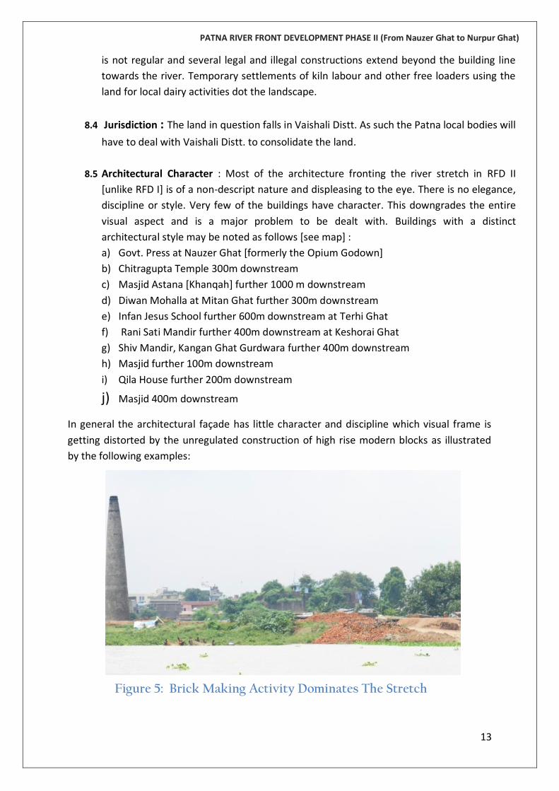
towards the river. Temporary settlements of kiln labour and other free loaders using the
land for local dairy activities dot the landscape.
8.4 Jurisdiction : The land in question falls in Vaishali Distt. As such the Patna local bodies will
have to deal with Vaishali Distt. to consolidate the land.
8.5 Architectural Character : Most of the architecture fronting the river stretch in RFD II
[unlike RFD I] is of a non-descript nature and displeasing to the eye. There is no elegance,
discipline or style. Very few of the buildings have character. This downgrades the entire
visual aspect and is a major problem to be dealt with. Buildings with a distinct
architectural style may be noted as follows [see map] :
a) Govt. Press at Nauzer Ghat [formerly the Opium Godown]
b) Chitragupta Temple 300m downstream
c) Masjid Astana [Khanqah] further 1000 m downstream
d) Diwan Mohalla at Mitan Ghat further 300m downstream
e) Infan Jesus School further 600m downstream at Terhi Ghat
f) Rani Sati Mandir further 400m downstream at Keshorai Ghat
g) Shiv Mandir, Kangan Ghat Gurdwara further 400m downstream
h) Masjid further 100m downstream
i) Qila House further 200m downstream
j) Masjid 400m downstream
In general the architectural façade has little character and discipline which visual frame is
getting distorted by the unregulated construction of high rise modern blocks as illustrated
by the following examples:
Figure 5: Brick Making Activity Dominates The Stretch

PATNA RIVER FRONT DEVELOPMENT PHASE II (From Nauzer Ghat to Nurpur Ghat)
14
Figure 6: Shelters of Brick Kiln Workers Occupy Flood Plain
Figure 8: Heritage Building Visible On RFD II
Figure 7: Distinct Architecture Of The Quila House Getting Concealed Behind Jhuggis

PATNA RIVER FRONT DEVELOPMENT PHASE II (From Nauzer Ghat to Nurpur Ghat)
15
Figure 9: Unregulated Multi-storey Flats Near Takhat Sahib Projecting Visually On The Landscape
Figure 11: Geobags Experiment By GoB To Prevent Bank Erosion
Figure 10: NIO Building Architecture Strikes A Discordant Note

PATNA RIVER FRONT DEVELOPMENT PHASE II (From Nauzer Ghat to Nurpur Ghat)
16
Figure 12: Bank Erosion As A Result Of Flood Flow
Figure 14: Garbage Dumping & Defecation Ground Presently
Figure 13: Unregulated Multi-storey Flats Near Takhat Sahib Projecting Visually On The Landscape

PATNA RIVER FRONT DEVELOPMENT PHASE II (From Nauzer Ghat to Nurpur Ghat)
17
Figure 17: Industrial Architecture Forms The Skyline Towards Eastern End
Figure 16: Several Masjids Are Part Of The Line Building
Figure 15 : Poor Architecture Will Ruin The Character Of The RFD II

PATNA RIVER FRONT DEVELOPMENT PHASE II (From Nauzer Ghat to Nurpur Ghat)
18
9. The Ganga Expressway 9.1 Of great significance is the proposal for Ganga Expressway which is proposed as a local
urban artery from near Hajipur Bridge [Ashok Rajpath] south-eastwards to NH 30 along
the shoreline. The Expressway has been proposed as some 60m wide and is partly based
on piers in the river bed and on surface wherever available. The project will bring in some
heavy traffic movement which will vitiate the ambience of the river front. It will also cut
off direct access to the river for residents. In the view of INTACH it would be best if the
project were avoided [an arterial road parallel and just south of the railway line would be
a better substitute at this point of time]. If the Expressway cannot be avoided then it
should be narrowed down to a 4 lane road 30 m wide [this will greatly reduce costs] and
be regulated to exclude commercial goods traffic. The on-surface sections should also be
based on piers in order to remain serviceable in the face of extreme flood erosion.
10. Access
10.1 In general the access to the river front from the city is rather poor, being through narrow
winding lanes which cannot be easily widened. These range between 2m – 5m wide
average width being about 3.5m. Five possibilities of main access are as follows:
Lane east of Govt. Press
Sadr Gali at Khajekalan Ghat
Proposed access widening at Kangan Ghat
Proposed access through Patna Ghat Station
Access from NH30 at Bakhtiarpur
In view of the restrictions to any form of traffic movement commercial and institutional
areas would not find this location encouraging unless smooth traffic access and parking is
guaranteed.
11. How To Hold Up A Bank 11.1 The shoreline is greatly prone to erosion especially in the monsoons. Earlier methods of
stone pitching have not been effective and on experimental basis geobags piling is being
Figure 19: Erosion Control with Jute Bags
Figure 18: Erosion Control with Sedge Grass

PATNA RIVER FRONT DEVELOPMENT PHASE II (From Nauzer Ghat to Nurpur Ghat)
19
carried out. Natural solutions, in this case are cheapest and most effective using grass
binding. The natural grass suitable for this purpose and native to the area is carex
caryophyllea which is also known as ‘wet meadow sedge’. This is highly effective and
economic form of soil retention as the root system of the grass grips the soil closely and
the dense grass dulls the erosive effect of high velocity river flow by leaving little space for
soil and moving water contact.
12. High Flood Level And City Drainage 12.1 Floods regularly hit Bihar during the June-September monsoon season as the Ganga and its
tributaries, many of which flow in from neighbouring Nepal, breach their banks. After
several continuous floods, govt raised the river bank which does not allow flood water to
enter in the city. Still, substantial area of RFD II is prone to flood inundation.
The lean season flow in the river is at a level of 51.5 mamsl whereas the high flood level is
at 61 mamsl a difference of 8.5m in elevation. It is seen that the entire RFD II area [average
level 53 mamsl] gets submerged under water in the monsoon season to an extent of 7m
and water comes into the building line inside the various ‘gallis’ [lanes] as can be seen in
the following images. The implications are :
that large parts of the RFD II will remain unusable for perhaps a couple of months until the
water level goes down
that little permanent constructions of buildings can be advised and that all built features
would be constructed above HFL either by way of being made on stilts or on raised earth
mounds
that circulation features must be built above the HFL at say 62 mamsl
Map 3; High Flood Level And Area Submerged Under Flood

PATNA RIVER FRONT DEVELOPMENT PHASE II (From Nauzer Ghat to Nurpur Ghat)
20
that thanks to the Ganga Expressway, which will be built on a raised berm in most of
RFD II, the surface area will be partially protected from river submergence while
simultaneously facing a lesser degree of submergence from stormwater influx from
Patna City as well as direct rainfall which will be difficult to drain off while the river
level is higher than 53m level
that electrical features would require especial safety precautions
Figure 20: Water Enters Building Line On Kangan Ghat [1 August, 2013 – This Is Still 1 m Below HFL]

PATNA RIVER FRONT DEVELOPMENT PHASE II (From Nauzer Ghat to Nurpur Ghat)
21
Figure 21: Building Encroachments On RFD Plain Unusable
Figure 22: Under Construction Pathway To Kangan Ghat Facing Submergence

PATNA RIVER FRONT DEVELOPMENT PHASE II (From Nauzer Ghat to Nurpur Ghat)
22
13. Physical Infrastructure condition 13.1 Patna suffers from a problem of plenty of water, sewage and solid waste. It depends on
the Ganga and groundwater for drinking. Less than 10 per cent of the city’s population is
connected to a sewage network; which means 90 per cent of the city’s excreta is
discharged into open drains and eventually into the ganga river.
Figure 23 : Untreated Sewage Discharge In Ganga
Figure 24 : Poor Living Condition
Map 4: Land Use Map of Patna City along River Ganga

PATNA RIVER FRONT DEVELOPMENT PHASE II (From Nauzer Ghat to Nurpur Ghat)
23
14. The Planning Criteria Having familiarized with relevant characteristics of the river front and its abutting premises
as well as the overarching feature of the Ganga Expressway and the concepts proposed in
RFD I, the following planning criteria emerge :
14.1 Access to river front, presently, is through narrow lanes. This picture will change with
o construction of Expressway
o road access from Old Patna Ghat Station to be extended to X-Way
o Sadr Gali upgradation
o Road adjacent Govt. Press
o Provision of a 7.5 km long pedestrian pathway to which all lanes will connect
o Formal upgradation of Ghats with occasional jetties enabling dispersed boat
embarkation/disembarkation points combined with tunnels under Expressway to
connect with land mass
Figure 27 : Lack of proper drainage system
Figure 28 : Chocked Drain & Water Spread On the Road
Figure 26 : Solid Waste Near Residential Area
Figure 25 : Dumped Solid Waste Near Water Bodies
PATNA RIVER FRONT DEVELOPMENT PHASE II (From Nauzer Ghat to Nurpur Ghat)
24
14.2 As reported earlier the architecture of the built area edge is visually repulsive in the
main and this situation is further compromised by lack of regulation of building
activity. While the access features proposed above would re-orient the city edge
towards the river and, combined with good building regulations seriously
implemented, may over a couple of decades, improve the river facing architecture
quality, this is not inevitable. Hence , it is proposed to create a screen of trees in the
main. Apart from trees at suitable stretches where supported by road access a
tightly controlled architectural component consisting of mixed use and institutional
areas would be developed as a screen in other areas – this would also provide a
remunerative element from which maintenance of the river front could be financed.
Architectural landmarks such as Quila House, Kangan Ghat Gurdwara and Takht
Sahib, Chitragupta Mandir and Govt. Press would be highlighted to retain the
positive elements of the city fabric.
14.3 Water Channel :The water filled linear pits occupy a length of 5 km. These would be
costly to fill up and the landscaped area would require heavy maintenance cost.
Instead, the pits can be combined and connected at eastern and western end to the
river. This would result in an internal water channel which would be reminiscent of
the old location of the river channel. This would require careful estimation of the
bed levels and control of silt inflow during the flood season by installation of gates
below the X-Way.
14.4 Patna City [Patliputra] in the RFD II stretch is a very congested area with high
population density, narrow roads and lacking in a network of green spaces. To a
great extent the RFD II will compensate for this lacuna by providing a varied green
landscape, recreational and sports facilities. Several forest zones will also be
provided to increase carbon sinks and fresh air.
14.5 The old Ghats structure will be retained and highlighted. Prominence to ghats will be
given by formalizing their structure and facilitating passenger boat landing. A major
jetty would be added at Patna Sahib Station axis and Damiahi Ghat
14.6 Erosion of River Bank : the vulnerability of the river edge to erosive forces during
flood season would be addressed by planting a strip of tall native grass [carex
caryophyllea which is also known as ‘wet meadow sedge’]. This would not only
prevent erosion by biological methods which are highly economic and requiring no
maintenance but also provide riparian habitats to birds and river fauna.
14.7 Inundation aspects : once the topographical survey of the area has been completed
the area vulnerable to inundation will be known. Here, it will have to be adjudged as to
the extent of protection the X-Way embankment would afford to the RFD II area and
to what extent it would act as a hindrance to drainage outflow to the river and keep
PATNA RIVER FRONT DEVELOPMENT PHASE II (From Nauzer Ghat to Nurpur Ghat)
25
the vast plain under submergence. A possible trap drain may have to be considered
along the linear pathway adjacent the building line to channel the city drainage to the
extremes
14.8 Lighting : Solar photovoltaics based lighting will be promoted along the walkways.
Other floodlighting with sodium vapour lamps would be introduced to light up the
open spaces.
14.9 Temporary city and mela grounds: a space has been earmarked for a temporary tented
city for pilgrims coming to attend the 350th birth anniversary celebrations of Shri Guru
Gobind Singh. This would be supported by mobile toilets and no permanent
construction is envisaged. Post the event the grounds will be available as a mela
ground or exhibition ground against revenue.
14.10 Public conveniences and commercial kiosks would be provided at suitable locations.
This will keep the area buzzing with activity while providing ‘eyes on the street’ for
security purposes.
15. Block Cost Estimate
S No. Sub- Project No.
Item Description Cost [Rs.]
1 Provision For Land Acquisitions x 30 ha 50,00,00,000/-
Sub-Total I 50,00,00,000/-
2 RA1 Earthworks :
Realignment of internal water channel [cut and fill] including dewatering for achieving the same [500,000 cu.m.]
Dredging of internal water channel to align with river bed levels for flow [600,000 cu.m.]
15,00,00,000/-
12,00,00,000/-
3 RA2 Earthworks : Bringing earth [3 MCM] from outside, laying in layers and dressed to shape, consolidated, for raising :
various walkways
tree planting strips
parking areas
institutional area
riverside facilities
landscape grading
90,00,00,000/-
Sub-Total II 117,00,00,000/-
4 RB1 Making steps and Ghats along river edge incorporating :
excavation

PATNA RIVER FRONT DEVELOPMENT PHASE II (From Nauzer Ghat to Nurpur Ghat)
26
dewatering
Lean concrete foundation
RCC foundation incl. steel reinforcement
Construction of steps in RCC
Red sandstone flooring
Red sandstone chattris and stone pillar lamps
4,00,00,000/-
5 RB 2* Construction of Riverside facilities :
Boat jetties at Damiahi Ghat and Patna Ghat
Viewing Tower with Elevators [PPP basis]
Riverside Facilities [PPP basis]
Construction of Kiosks
Construction of Public Conveniences
30,00,00,000/-
6 RB3 Erosion Control : Plantation and establishment of river edge sedge grass [25000 sq.m]
40,00,000/-
Sub-Total III 34,40,00,000/-
7 W 1 Construction of Walkways [Brush finished RCC [M 200] with MS reinforcement, over LC [1:4:8], over consolidated earth]
15m wide [5500 m]
10 m wide [5000 m]
29,75,00,000/- 18,00,00,000/-
8 W2 Improvement of 16 No. Lanes [approx length 150m each] accessing RFD II :
12,00,00,000/-
9 W3 Construction of Bridges [15 No.s] crossing internal water channel
15,00,00,000/-
10 W4 Construction of stepped ghats on both sides of internal water channel
50,00,00,000/-
11 W 5 Construction of mechanically operated gates for controlling water flow and silt at both ends of internal water channel at connection points to River
10,00,00,000/-
Sub-Total IV 134,75,00,000/-
12 L 1 Plantation of trees in screening strip, forest zones, etc. Including pit preparation, tree guards
15,00,000/-
13 L 2 Landscape works [grass, flowers, pavings, features] 15,00,00,000/-
14 L 3 Dancing Water Fountains [15 no.s] 2,00,00,000/-
15 L 4 Construction of sports facilities and courts [incl. astro turf hockey field]
5,00,00,000/-
16 L 5 Jal Mahal and geometric gardens and pathways 10,00,00,000/-
17 L 6 Construction of floating stages in inner water channel 1,00,00,000/-
Sub-Total V 33,15,00,000/-
18 B 1** Construction of Club [3 ha plot area] in PPP mode 16,00,00,000/-
19 B 2** Construction of institutional area/mixed use development with controlled facades [11 ha plot area, built area 100,000 sq.m.] in PPP mode
250,00,00,000/-
Sub-Total VI [Not Taken in Total As Privately Financed] 266,00,00,000/-

PATNA RIVER FRONT DEVELOPMENT PHASE II (From Nauzer Ghat to Nurpur Ghat)
27
20 E 1 Installation of high mast floodlights [20 no.s] 1,00,00,000/-
21 E 2 Installation of LCD streetlights @ 20m spacing along walkways [750 no.s] [solar photovoltaics supported]
4,50,00,000/-
22 E 3 Electrical cabling, switchgear, sub-station, gen set backup, miscellaneous lighting and power supply
15,00,00,000/-
Sub-Total VII 20,50,00,000/-
23 M 1 Street Furniture 2,00,00,000/-
24 M 2 Graphic Signages 1,00,00,000/-
25 M 3 Playground Equipment [including boats] 2,00,00,000/-
26 M 4 Chain link fencing 4,00,00,000/-
Sub-Total VIII 7,00,00,000/-
27 T 1 Construction of Road to Patna Ghat [350m x 45m ROW] 9,50,00,000/-
28 T 2 Construction of Road from Old Patna Ghat Station to X-Way [2800m x 30m ROW]
50,00,00,000/-
Sub-Total IX 59,50,00,000/-
29 H 1 Water Supply Infrastructure for Irrigation, public conveniences, proposed institutional buildings and mixed developments consisting of :
Shallow Tubewells x 15 no.s
5 MLD local water treatment plant
Supply pipelines
Sprinkler system
1,00,00,000/- 2,50,00,000/- 2,50,00,000/- 4,00,00,000/-
Sub-Total IX 10,00,00,000/-
30 Contingencies 45,00,00,000/-
GRAND TOTAL 511,30,00,000/-
[Rupees Five Hundred Eleven Crores Thirty Lakhs Only] *Remunerative Projects ** Remunerative projects not taken into estimated cost
*****************