past flooding and scheme objectives
TRANSCRIPT

Scheme Objectives:
• To provide long term flood alleviation to
Stonehaven.
• To reduce the likelihood and impact of
fluvial flooding from the Carron Water.
• To enhance or maintain the existing
environment.
• To avoid adverse environmental and
geomorphological impacts.
• 372 properties at risk.
• Scheme estimated to avert over £14m of
flood damages.
PAST FLOODING AND SCHEME OBJECTIVES
OCTOBER 1979.OCTOBER 1979.
HIGH STREET 2012. NOVEMBER 2009
STONEHAVEN FLOOD MAP AREA
TIMELINE OF PAST FLOOD EVENTS
DECEMBER 2012
DECEMBER 2012
BEACH
ST JAMES’ CHURCH
GREEN BRIDGE
WHITE BRIDGE
RED BRIDGE

Option Pros ConsOption 1
Continued Maintenance and Repairs
• Low initial expenditure • No real alleviation
• Recurring costs can add up
Option 2
Direct Defences
• Good cost-benefit ratio
• Low operational and maintenance requirements
• Very high walls required
• Possible impact on cultural heritage
• Loss of connection with river
Option 3
Direct Defences with Channel & Bridge
Modifications
• Good cost-benefit ratio
• Improvements to footbridges
• Low operational and maintenance requirements
• Opportunity for streetscaping
• Raised walls
• Possible impact on cultural heritage
Option 4
Upstream Storage
• Construction outwith Stonehaven
• Possible creation of wetlands
• Potential impact on fisheries and geomorphology
• Complex design and high maintenance costs
• Operational requirement during flood event
Option 5
Direct Defences with Upstream Storage
• Improvement to footbridges
• Possible creation of wetlands
• Potential impact on fisheries and geomorphology
• Complex design and high maintenance costs
• Operational requirement during flood event
• Construction in and out of Stonehaven
Option 6
Increase Flood Resilience
• Low initial expenditure
• Community ownership of risk reduction
• Minimal environmental impact
• Limited effectiveness
• Low cost-benefit ratio
• Disruption during flood event
• Advanced warning may be limited
Direct Defences with Bridge/Channel Modifications Upstream Storage
Increase Flood Resilience
SCHEME DEVELOPMENT – OPTIONS APPRAISAL• A review of options was undertaken in 2013.
• A number of options were reviewed,
provided in the table above.
• These options were assessed on a number of
criteria, including cost-benefit, impact on
habitats, complexity and cultural heritage.
• Option 3 was chosen to be taken to detailed
design.
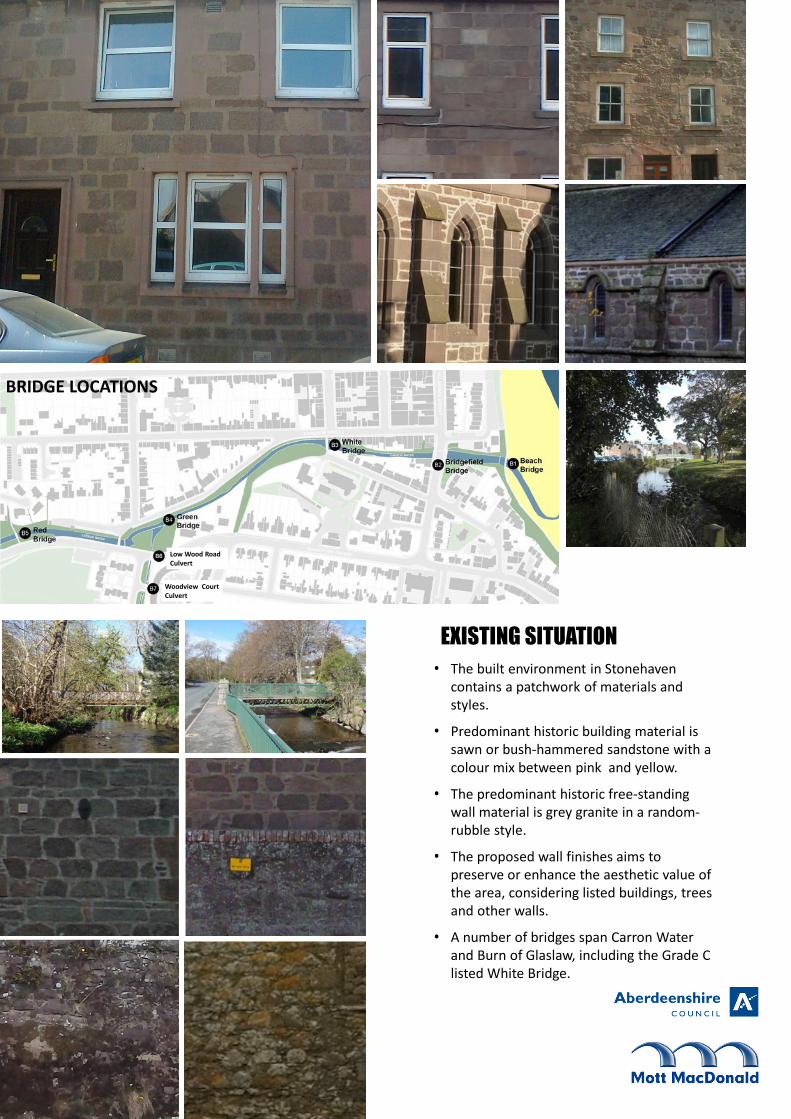
EXISTING SITUATION
BRIDGE LOCATIONS
• The built environment in Stonehaven
contains a patchwork of materials and
styles.
• Predominant historic building material is
sawn or bush-hammered sandstone with a
colour mix between pink and yellow.
• The predominant historic free-standing
wall material is grey granite in a random-
rubble style.
• The proposed wall finishes aims to
preserve or enhance the aesthetic value of
the area, considering listed buildings, trees
and other walls.
• A number of bridges span Carron Water
and Burn of Glaslaw, including the Grade C
listed White Bridge.
Low Wood Road
Culvert
Woodview Court
Culvert

99%AEP tide level
LONG SECTION ON CARRON WATER
0.5%AEP tide level
Be
ach
Bri
dge
Bri
dge
fie
ldB
rid
ge
Re
d B
rid
ge
Ra
ise
d
Gre
en
Bri
dge
Re
loca
ted
River bed lowered to
increase river capacity to
minimise wall heights
upstream
HYDRAULICS• White Bridge and Red Bridge will be raised to reduce
water levels upstream.
• Walls will be raised in some areas to accommodate
high water levels upstream of unraised bridges – such
as at Bridgefield Bridge.
• The works are designed using a hydraulic model to
accommodate the peak river flow for the 0.5%
annual exceedance probability (AEP) flood event.
• An allowance for future climate change is included
• Options are hydraulically modelled to determine
optimum layout in terms of wall height, environment
effects and cost.
• Self raising flood barriers will be installed where new
wall heights would have a significant impact.
• The tide level is much lower than design flood levels,
and so design flood levels are not influenced by tides.
FLOWS AT THE PEAK OF THE DESIGN STORM
DESIGN INFLOW
Time
Flo
w
Wh
ite
Bri
dge
Ra
ise
d
Leve
l (m
AO
D)
Distance downstream (m)
Proposed River Bed Level
Existing River Bed Level
Peak Flood Level with Beach Bridge removed
Peak Flood Level with part of rock armour
removed
Design Peak Flood Level

GREEN BRIDGE TO WHITE BRIDGE SOLUTION
WHITE BRIDGE TO BRIDGEFIELD BRIDGE SOLUTION
WHITE BRIDGE AREA
CARRON GARDENS SOLUTION
REVIEWED STONE FOR WALL FINISH
REVIEWED STONE FOR COPING FINISH
REVIEWED STONE FOR WALL FINISH
Outline Wall Solutions
BEACH
ST JAMES’ CHURCH
GREEN BRIDGE
WHITE BRIDGE
RED BRIDGE
KEY WALL FINISHES
Random Stone-faced on road side
Patterned concrete on river side
Random Stone-faced on road side
Random Stone-faced on river side
Random Stone-faced on garden side
Random Stone-faced on river side
Self closing barriers
• A random rubble finish with an
undressed coping stone is proposed for
the majority of areas.
• Dressed copings have been proposed in
some area where appropriate or required
for self closing barriers.
PROPOSED SOLUTIONS
• The wall finish aims to preserve
or enhance the aesthetic value
of the area, considering listed
buildings and other walls

BURN OF GLASLAW AND RED
BRIDGE TO GREEN BRIDGE
• Red Bridge is to be replaced with a similar bridge at a
higher level at the same location.
• The culverts on the Burn of Glaslaw are to be replaced
with larger culverts to improve the conveyance of the
watercourse.
• The Burn of Glaslaw will be widened to improve efficiency
along with the widened culverts.
• As this section is outwith the Conservation Area of
Stonehaven patterned concrete will be used as a finish to
the walls, using a similar pattern and colour to the walls
nearby.
PROPOSED PATTERNED CONCRETE WALL FACING ON RIVER SIDE OF WALL
PROPOSED RANDOM STONE WALL FACING ON ROAD SIDE OF WALL
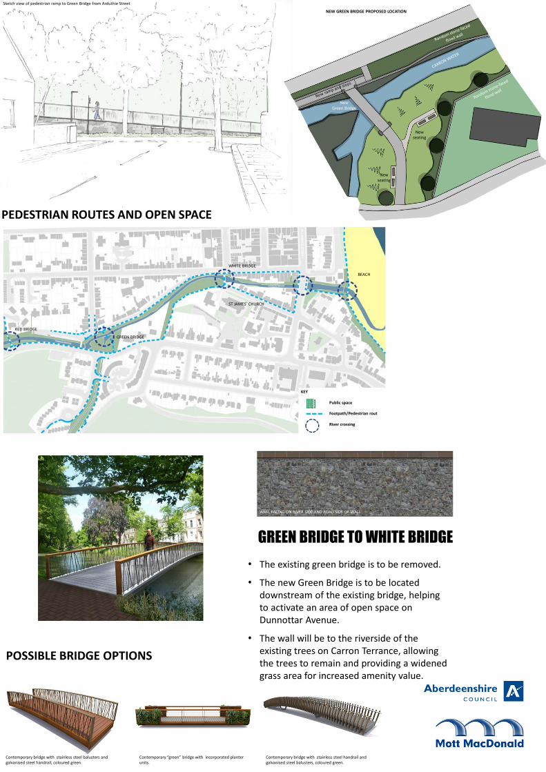
Sketch view of pedestrian ramp to Green Bridge from Arduthie Street
Contemporary “green” bridge with incorporated planter
units.
Contemporary bridge with stainless steel handrail and
galvanised steel balusters, coloured green.
GREEN BRIDGE TO WHITE BRIDGE
PEDESTRIAN ROUTES AND OPEN SPACE
• The existing green bridge is to be removed.
• The new Green Bridge is to be located
downstream of the existing bridge, helping
to activate an area of open space on
Dunnottar Avenue.
• The wall will be to the riverside of the
existing trees on Carron Terrance, allowing
the trees to remain and providing a widened
grass area for increased amenity value.
New
seating
New
seating
New
Green Bridge
BEACH
ST JAMES’ CHURCH
GREEN BRIDGE
WHITE BRIDGE
RED BRIDGE
KEY
Public space
Footpath/Pedestrian rout
River crossing
WALL FACING ON RIVER SIDE AND ROAD SIDE OF WALL
NEW GREEN BRIDGE PROPOSED LOCATION
POSSIBLE BRIDGE OPTIONS
Contemporary bridge with stainless steel balusters and
galvanised steel handrail, coloured green.

Proposed flood defence solution looking north from the
White Bridge. View is indicative of walls without self-raising
barrier in operation.
WHITE BRIDGE
• The narrow river channel here constrains the river. A buried
culvert is proposed to assist in construction and to improve
the conveyance of flood waters in this area.
• White Bridge is to be raised and the channel lowered to
help increase the capacity of the river.
• St James’ Church is a dominant feature in this area and the
preservation of its setting is a critical consideration for the
design of flood defences here. The flood walls are to
remain a similar height to existing, with self closing barriers
used to provide a high level flood defence which are
activated during a flood event.
Flood Wall and Gate
White Bridge
CARRON TERRACE
Random stone-faced flood wall
Random stone-faced
flood wall
Random stone-faced flood
walls to either side
CARRON WATER
ST JAMES’ CHURCH
BEACH
ST JAMES’ CHURCH
GREEN BRIDGE
WHITE BRIDGE
RED BRIDGE
Self closing barriers to north bank
Self-raising barriers
to north bank
New footway arrangement in Carron Terrace
CONSERVATION AND HERITAGE
WALL FACING ON RIVER SIDE AND ROAD SIDE OF WALL

Proposed flood defence solution looking west from
Bridgefield. View is indicative of walls without self-raising
barrier in operation. Proposed flood defence walls looking east from Bridgefield.
Self-raising, glass, flood walls to be incorporated in
sensitive locations
BRIDGEFIELD BRIDGE TO BEACH BRIDGE• The bed of the river under Bridgefield Bridge is to be
lowered to increase river capacity.
• Self closing barriers are proposed to minimise wall heights
along Cameron Street.
• Downstream of Bridgefield Bridge, a new footpath is
proposed on the right bank to improve links to Stonehaven
seafront.
BEACH
WALL FACING ON RIVER SIDE AND ROAD SIDE OF WALL
Carron Water
Carron Water
Carron Water
Carron Water
GardenGardenGardenGardenGarden
Bu
ildin
g L
ine
Bu
ildin
g L
ine
Bu
ildin
g L
ine
Bu
ildin
g L
ine
Bu
ildin
g L
ine
In the default position, the self
closing barrier is concealed
within the wall unit at the end of
the garden.
An outlet and inlet pipe are
located within the wall unit.
As the flood water rises the
outlet pipe is blocked by a flap.
Once the flood water reaches
the inlet pipe, it flows into the
concealed reservoir within the
wall unit.
As the concealed reservoir fills
with water, it lifts the self
closing barrier through hydraulic
force.
Inlet
Outlet
Carron Water
Once the flood water recedes,
the water in the reservoir flows
from the outlet pipe allowing the
self closing barrier to return to
its default position

QWhy can’t flood water be stored
upstream, instead of having walls
through Stonehaven?
AThe catchment of Carron Water is
short and steep and does not lend
itself to flood storage. Storage has
been looked at upstream, but
would require similar works to walls
through Stonehaven, as well as the
construction of the dam, which is
not viable.
QWhy is the Flood Protection
Scheme required?
ATo defend the centre of Stonehaven
from fluvial flooding, similar to that
experienced in 2012
QWill risk of flooding be
transferred upstream?
ANo, there is no increase in flood
water levels upstream of the
flood scheme.
QWhat are the extents of the flood
protection works?
AFrom Beach Bridge to Red Bridge on
Carron Water and along the Burn of
Glaslaw to beyond houses on Carron
Gardens, defending properties in
Stonehaven.
QHow is the scheme
funded?
AAberdeenshire Council is
funding the scheme, but
are seeking funding from
Scottish Government.
QHow will the scheme/flood barriers
work? Can the barriers become
lodged or fail?
AThe barriers work under hydraulic
pressure and can lift a car if
necessary. The barriers are
interlinked, so if one fails it will be
lifted by its adjacent gates.
Numerous connections to the river
will be made to minimise risk of
failure.
QHow many properties will be
affected by the Flood
Protection Scheme?
A372 properties will be
defended by the scheme.
QHow high are the walls?
AThe walls vary in height. In general
wall are between 1.2 and 1.8m
higher than ground level on the dry
side of the wall. The scheme is
designed to minimise wall heights
as much as possible, limiting
heights to below 1.5m, which can
still be seen over by an average
adult. Self raising barriers have
been used where wall heights are
considered particularly sensitive.
QHow will the scheme be constructed?
How much disruption will there be?
AThe works will be constructed from
the watercourse and the roads next
to the watercourse. There will need to
be closures, diversions and
restrictions on the roads next to the
river for vehicles. However,
pedestrian access will be maintained
on all roads.
.
QWhen will the scheme be
completed? How long do the works
take?
AThe works are likely to take 2 years
to complete once on site, but this
depends on the number of
objections and the nature of those
objections. If construction started
in 2017, then it is likely to be
completed in 2019.
QWill I still be able to cross the
river during construction?
AA crossing will be maintained in
a similar location to the existing
bridges during the works except
for Red Bridge which will be
closed for a few months.
QWhat does 0.5% AEP flood defence
mean? Why this level of protection?
A0.5%AEP is the annual exceedance
probability, so the chance that a
flood event of that size of flow
coming down the river in any given
year, based on a statistical analysis
of past flood events. This is the
standard level of protection
required by the Scottish
Government and SEPA for a
residential area.
QWhat measures are there to protect
fish and other wildlife that may be
affected?
AThe scheme aims to maintain or
enhance the ecology of the river,
such as by removing fish
obstructions at Green Bridge.
During the works, the river channel
will be diverted through culverts
and pipes to maintain the river flow
and maintain fish passage during
the works, whilst allowing
construction to continue.
QCan we not just open up the outlet
to the sea, that must cause flooding
upstream?
AThe hydraulic modelling indicates
that lowering of the rock armour
downstream of White Bridge does
not significantly reduce water levels
upstream. The bridges and channel
width are the main constrictions to
river flow, that dictate the design
water levels on the river.
.
QWhy are there no ramps at White
Bridge?
ARamps were considered for White
Bridge. The inclusion of a ramp
would require higher walls on
Cameron Street over its 20m length
and would require the pavement to
be widened for this length,
removing car car parking. Due to
the important visual setting of this
section of the works steps are
proposed to minimise the impact
and minimise wall height.

WHAT NEXT?
OUTLINE DESIGN OF PREFERRED OPTION
Environmental Assessment
FLOOD RISK MANAGEMENT ACT SUBMISSION
Site investigation, trial pits and testing
Detailed design
FLOOD RISK MANAGEMENT ACT APPROVAL
Tender
CONSTRUCTION
May 2015
June 2015
July 2015
December
2015
July 2016
January
2017
• The scheme now needs consent to be constructed from the
Scottish Government under the Flood Risk Management
(Scotland) Act 2009.
• The time to deliver the project will be dependent on the
number and nature of any objections received.
• Site investigations and detailed design of the scheme will
be undertaken during the consenting period to refine
proposals.