passage planning
TRANSCRIPT
DEPARTMENT OF TRADE
A Guide to the Planning and Conduct of Sea Passages
LONDON HER MAJESTY'S STATIONERY OFFICE

Contents
Preface Introduction Bridge organisation Pilotage Responsibility for passage planning Principles of passage planning i appraisal
ii planning iii execution iv monitoring
Annex I details of parallel indexing techniques
i basic principles ii plotting
iii deviations from course line iv margins of safety v precautions
Annex II a worked example of planning for a passage
1 general appraisal 2 planning
chartlets . . . A B C D E
Annex III check list of items for passage appraisal
Preface
This booklet was prepared by a group of twelve experts in the nautical field representing a wide range of interests in the shipping industry including those of shipowners, the MNAOA, a serving Pilot, a serving Shipmaster, a nautical college, the Royal Navy, Trinity House and the Department of Trade. The information it provides is designed to assist Masters and deck officers in the planning, execution and monitoring of passages.
Acknowledgement is due to Shell Tankers (UK) Limited for the use of their material in Annex 1 to the booklet.
Introduction
1. The aim of this Guide is to set out a code of practice for the following two essentially inter-related aspects:
(a) the organisation required for the planning of sea passages, and (b) the subsequent requirements to ensure that such sea passages are accomplished in
compliance with the plan.
2. It is generally recognised that both the planning of passages and the close and continuous monitoring of position during the execution of such plans are necessary and highly important in the interests of safe navigation.
3. The need for effective planning and position monitoring during the conduct of a passage applies to all ships. More constraints apply to larger ships and there will be a corresponding need for these to be taken into account both in the preparation of the plan and equally in its subsequent monitoring.
4. A disturbing number of casualties, particularly strandings, continue to occur in restricted waters and port approaches. Although these casualties are small in number relative to the total number of ships trading, many of these could have been avoided by detailed passage planning.
5. Arrangements for ensuring the effective planning and conduct of passages are a vital element in the wider requirement for an effective bridge organisation. General guidance on bridge organisation is contained in IMCO Resolution A 285 (VIII), adopted at the IMCO Assembly in November 1973. That Resolution, contained in Merchant Shipping Notice M.756 (Keeping a Safe Navigational Watch), should be studied in conjunction with this Guide, which also complements, but does not supersede, the information given in the Bridge Procedures Guide published by the International Chamber of Shipping, the relevant parts of which are:
Paragraph 1.2 - Passage Plan Paragraph 2.7 - Navigation in Coastal Waters/Traffic Separation Schemes Paragraph 2.10 - Navigation with Pilot embarked Check List 5 - Master/Pilot information exchange Check List 6 - Navigation, Coastal Waters Check List 8 - Navigation, Deep Sea
6. The principles outlined in this Guide are not new; they have long been practised in many ships.
Bridge organisation
7. In this Guide, the term 'Bridge Team' refers to those employed in the navigation of the ship. This does not preclude masters and skippers in small ships forming a bridge team, which would obviously be limited as to its size. It is the responsibility of the Master or Skipper to allocate specific tasks to his bridge team in order that safe navigation throughout the voyage can be effectively achieved.
8. In view of the wide variety of circumstances that apply, nothing hard and fast can be laid down in this Guide with regard to the allocation of tasks by masters; in order to avoid misunderstanding however, especially in the case of a prolonged passage in confined waters, it is recommended that Masters should issue precise instructions in writing in advance of the passage to be undertaken.
9. It will be apparent that in some areas, such as the English Channel, Southern North Sea, The Sound, the Gulf of St. Lawrence, the Japanese Inland Sea, the Gulf of Hormuz and the Malacca/Singapore Straits, ships will be in confined waters for a substantial period of time. Throughout this period the normal rotation of deck watches, with corresponding changes in officers of the watch, will apply. In these circumstances, it is even more important that all officers of the watch should be fully acquainted in advance with the details of the passage plan since, while on watch, it will be their responsibility to ensure that it is followed. Officers should also be made aware of the manoeuvres planned for the approach to the Pilot boarding point, with alternative courses of action where appropriate.

Pilotage
10. The contribution which Pilots make to the safety of navigation in confined waters and port approaches, of which they have up-to-date knowledge, requires no emphasis; but it should be stressed that the responsibilities of the ship's navigational team do not transfer to the Pilot and the duties of the Officer of the Watch remain with that officer.
11. After his arrival on board, in addition to being advised by the Master of the manoeuvring characteristics and basic details of the vessel for her present condition of loading, the Pilot should be closely consulted on the passage plan to be followed. The general aim of the Master should be to ensure that the expertise of the Pilot is fully supported by the ship's bridge team. (See also paragraph 25).
12. Attention is drawn to the following extract from IMCO Resolution A 285 (VIII): "Despite the duties and obligations of a Pilot, his presence on board does not relieve the officer of the watch from his duties and obligations for the safety of the ship. He should co-operate closely with the Pilot and maintain an accurate check on the vessel's position and movements. If he is in any doubt as to the Pilot's actions or intentions, he should seek clarification from the Pilot and if doubt still exists he should notify the master immediately and take whatever action is necessary before the master arrives."
Responsibility for passage planning
13. In most deep-sea ships it is customary for the Master to delegate the initial responsibility for preparing the plan for a passage to the officer responsible for navigational equipment and publications, usually the Second Officer. For the purposes of this Guide the officer concerned will be referred to as the Navigating Officer.
14. It will be evident that in small ships, including fishing boats, the Master or Skipper may himself need to exercise the responsibility of the Navigating Officer for passage planning purposes
15. The Navigating Officer has the task of preparing the detailed passage plan to the Master's requirements prior to departure. In those cases when the port of destination is not known or is subsequently altered, it will be necessary for the Navigating Officer to extend or amend the original plan as appropriate.

Principles of passage planning
16. There are four distinct stages in the planning and achievement of a safe passage: 1. Appraisal 2. Planning 3. Execution 4. Monitoring
17. These stages must of necessity follow each other in the order set out above. An appraisal of information available must be made before detailed plans can be drawn up and a plan must be in existence before tactics for its execution can be decided upon. Once the plan and the manner in which it is to be executed have been decided, monitoring must be carried out to ensure that the plan is followed.
Appraisal
18. This is the process of gathering together all information relevant to the contemplated passage. It will of course be concerned with navigational information shown on charts and in publications such as sailing directions, light lists, current atlas, tidal atlas, tide tables, Notices to Mariners and publications detailing traffic separation and other routeing schemes, and radio aids to navigation. Reference should also be made to climatic data and other appropriate meteorological information which may have a bearing upon the availability for use of navigational aids in the area under consideration such as, for example, those areas subject to periods of reduced visibility.
19. A check list should be available for the use of the Navigating Officer to assist him to gather together all the information necessary for a full passage appraisal and the circumstances under which it is to be made. It is necessary to recognise that more up-to-date information, for example radio navigational warnings and meteorological forecasts, may be received after the initial appraisal.
20. In addition to the obvious requirement for charts to cover the area or areas through which the ship will proceed, which should be checked to see that they are corrected up-to-date in respect of both permanent and temporary Notices to Mariners and existing radio navigational warnings, the information necessary to make an appraisal of the intended passage will include details of:
(a) Currents (direction and rate of set) (b) Tides (times, heights and direction and rate of set) (c) Draught of ship during the various stages of the intended passage (d) Advice and recommendations given in sailing directions (e) Navigational lights (characteristics, range, arc of visibility and anticipated raising
range (f) Navigational marks (anticipated range at which objects will show on radar and/or will
be visible to the eye) (g) Traffic separation and routeing schemes (h) Radio aids to navigation (availability and coverage of Decca, Omega, Loran and
D/F and degree of accuracy of each in that locality) (i) Navigational warnings affecting the area (j) Climatological data affecting the area (k) Ships's manoueuvring data.
21. An overall assessment of the intended passage should be made by the Master, in consultation with the Navigating Officer and other deck officers who will be involved, when all relevant information has been gathered. This appraisal will provide the Master and his bridge team with a clear and precise indication of all areas of danger, and delineate the areas in which it will be possible to navigate safely taking into account the calculated draught of the ship and planned under-keel clearance. Bearing in mind the condition of the ship, her equipment and any other circumstances, a balanced judgement of the margins of safety which must be allowed in the various sections of the intended passage can now be made, agreed and understood by all concerned.
Planning
22. Having made the fullest possible appraisal using all the available information on board relating to the intended passage, the Navigating Officer can now act upon the Master's instructions to prepare a detailed plan of the passage. The detailed plan should embrace the whole passage, from berth to berth, and include all waters where a Pilot will be on board.
23. The formulation of the plan will involve completion of the following tasks:
(a) Plot the intended passage on the appropriate charts and mark clearly, on the largest scale charts applicable, all areas of danger and the intended track taking into account the margins of allowable error. Where appropriate, due regard should be paid to the need for advance warning to be given on one chart of the existence of a navigational hazard immediately on transfer to the next. The planned track should be plotted to clear hazards at as safe a distance as circumstances allow. A longer distance should always be accepted in preference to a shorter more hazardous route. The possibility of main engine or steering gear breakdown at a critical moment must not be overlooked.
(b) Indicate clearly in 360 degree notation the true direction of the planned track marked on the charts.
(c) Mark on the chart those radar-conspicuous objects, ramarks or racons, which may be used in position fixing.
(d) Mark on the charts any transit marks, clearing bearings or clearing ranges (radar) which may be used to advantage. It is sometimes possible to use two conspicuous clearing marks where a line drawn through them runs clear of natural dangers with the appropriate margin of safety; if the ship proceeds on the safe side of this transit she will be clear of the danger. If no clearing marks are available, a line or lines of bearings from a single object may be drawn at a desired safe distance from the danger; provided the ship remains in the safe segment, she will be clear of the danger.
(e) Decide upon the key elements of the navigational plan. These should include but not be limited to: (i) safe speed having regard to the manoeuvring characteristics of the ship and, in ships restricted by draught, due allowance for increase of draught due to squat and heel effect when turning (ii) speed alterations necessary to achieve desired ETA's en route, e.g. where there may be limitations on night passage, tidal restrictions etc. (iii) positions where a change in machinery status is required (iv) course alteration points, with wheel-over positions where appropriate on large scale charts taking into account the ship's turning circle at the planned speed and the effect of any tidal stream or current on the ship's movement during the turn (v) minimum clearance required under the keel in critical areas (having allowed for height of tide)
(vi) points where accuracy of position fixing is critical, and the primary and secondary methods by which such positions must be obtained for maximum reliability (vii) contingency plans for alternative action to place the ship in deep water or proceed to an anchorage in the event of any emergency necessitating abandonment of the plan.
24. Depending on circumstances, the main details of the plan referred to in paragraph 23 above should be marked in appropriate and prominent places on the charts to be used during the passage. These main details of the passage plan should in any case be recorded in a bridge notebook used specially for this purpose to allow reference to details of the plan at the conning position without the need to consult the chart. Supporting information relative to the passage such as times of high and low water, or of sunrise or sunset, should also be recorded in this notebook.
25. It is unlikely that every detail of a passage will have been anticipated, particularly in pilotage waters. Much of what will have been planned may have to be changed after embarking the Pilot. This in no way detracts from the real value of the plan, which is to mark out in advance where the ship must not go and the precautions which must be taken to achieve that end, or to give initial warning that the ship is standing into danger.
Execution
26. Having finalised the passage plan, and as soon as estimated times of arrival can be made with reasonable accuracy, the tactics to be used in the execution of the plan should be decided. The factors to be taken into account will include:
(a) the reliability and condition of the ship's navigational equipment; (b) estimated times of arrival at critical points for tide heights and flow; (c) meteorological conditions, particularly in areas known to be affected by frequent
periods of low visibility; (d) daytime versus night-time passing of danger points, and any effect this may have upon
position fixing accuracy; (e) traffic conditions, especially at navigational focal points.
27. It will be important for the Master to consider whether any particular circumstance, such as the forecast of restricted visibility in an area where position fixing by visual means at a critical point is an essential feature of the navigation plan, introduces an unacceptable hazard to the safe conduct of the passage; and thus whether that section of the passage should be attempted under the conditions prevailing, or likely to prevail. He should also consider at which specific points of the passage he may need to utilise additional deck or engine room personnel.
Monitoring
28. The close and continuous monitoring of a ship's progress along the pre-planned track is essential for the safe conduct of the passage (Bridge Procedures Guide Chapter 3). If the Officer of the Watch is ever in any doubt as to the position of the ship or the manner in which the passage is proceeding he should immediately call the Master and, if necessary, take whatever action he may think necessary for the safety of the ship.
29. The performance of navigational equipment should be checked prior to sailing, prior to entering restricted or hazardous waters and at regular and frequent intervals at other times throughout the passage.
30. Advantage should be taken of all the navigational equipment with which the ship is fitted for position monitoring, bearing in mind the following points:
(a) visual bearings are usually the most accurate means of position fixing (b) every fix should, if possible, be based on at least three position lines (c) transit marks, clearing bearings and clearing ranges (radar) can be of great assistance (d) when checking, use systems which are based on different data (e) positions obtained by navigational aids should be checked where practicable by visual
means (f) the value of the echo sounder as a navigational aid (g) buoys should not be used for fixing but may be used for guidance when shore marks
are difficult to distinguish visually; in these circumstances their positions should first be checked by other means
(h) the functioning and correct reading of the instruments used should be checked (i) an informed decision in advance as to the frequency with which the position is to be fixed should be made for each section of the passage.
31. On every occasion when the ship's position is fixed and marked on the chart in use, the estimated position at a convenient interval of time in advance should be projected and plotted.
32. Radar can be used to advantage in monitoring the position of the ship by the use of parallel indexing techniques. Parallel indexing, as a simple and most effective way of continuously monitoring a ship's progress in restricted waters, can be used in any situation where a radar-conspicuous navigation mark is available and it is practicable to monitor continuously the ship's position relative to such an object. Details of parallel indexing techniques are given in Annex I to this Guide.
33. A worked example of planning for a passage is given in Annex II to this Guide. This example
(a) suitably illustrates the planning and conduct of passages as recommended in this guide;
(b) demonstrates that the procedure for the effective planning and conduct of passages is well within the competence of professional navigators;
(c) provides a clear indication that given the necessary emphasis and detailed attention, the application of the principles outlined in this Guide can readily enhance the safety of navigation.
34. A sample check list of items for passage appraisal is given in Annex III to this Guide.
Marine Division Deparment of Trade
May 1980

Annex I Details of parallel indexing techniques

PARALLEL INDEXING
Basic Principles
When a ship is steaming a steady course, any fixed object appears to move in a reciprocal direction at the same speed.
This, of course, is readily apparent on a radar screen when the radar is operating in "relative motion" — every fixed object appears to move in the opposite direction.
If, for example, a ship were proceeding down Channel at 12 knots with a course set to pass 5 miles south of Lizard Point, chart positions at 30 minute intervals might appear as shown on Chart 1. If, at the same time, the radar was operating on relative motion — i.e. with the ship's position apparently fixed in the centre of the screen — Lizard Point would appear to move in the opposite direction (indicated on the chart by a pecked line). On the Radar Screen this movement would appear as shown in Fig. (i).
It follows that if the ship maintains course then Lizard Point must also maintain this reciprocal movement. Therefore, if this reciprocal course were first plotted from Lizard Point, as the ship passed the Lizard any deviation from course would result in the echo of Lizard Point moving away from the plot on the reflection plotter.


PLOTTING
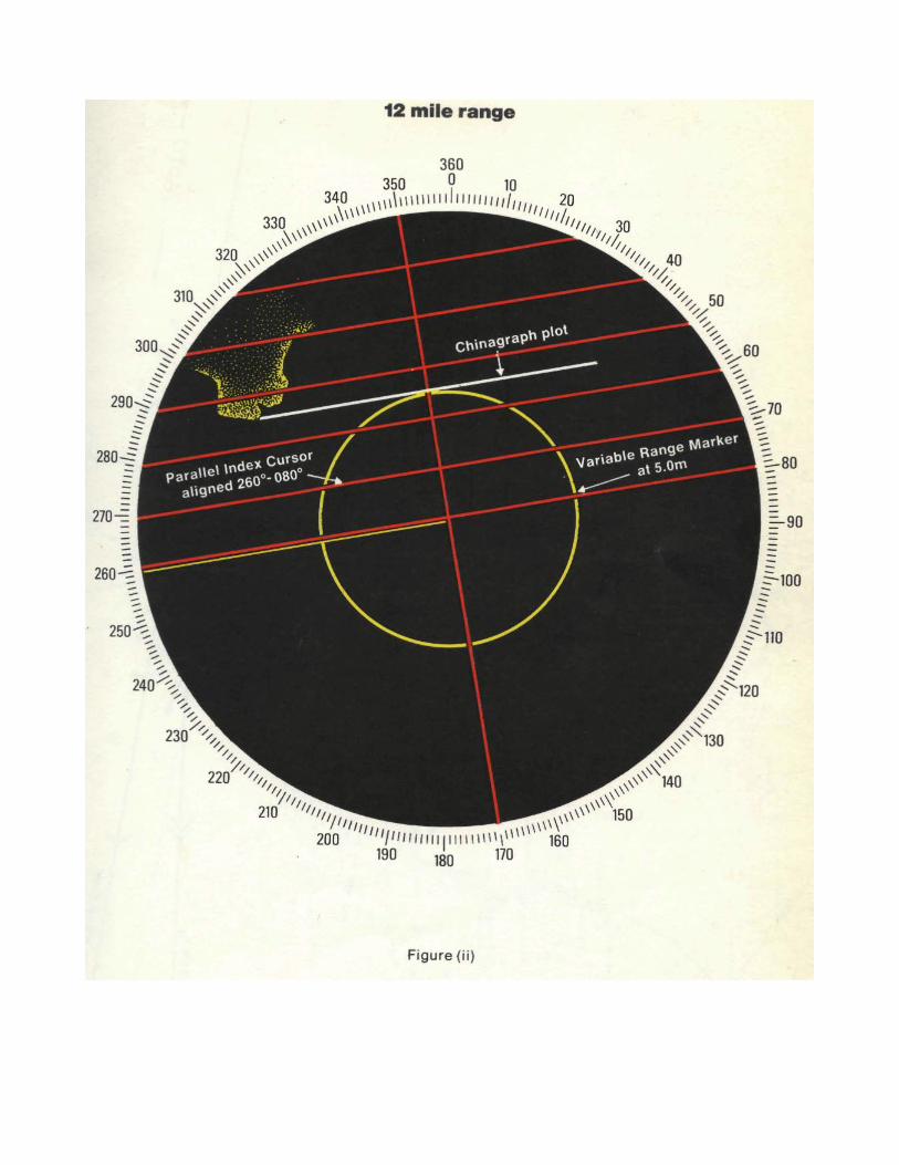
To make the plot on the reflection plotter the variable range marker and the parallel bearing cursor are used.
First, the bearing cursor is aligned with the desired course to make good, then the variable range marker is set at the "distance off — in this case 5 miles. Then, using a plotting ruler and chinagraph pencil the reciprocal course is drawn off from the fixed radar target, i.e. Lizard Point (see Fig. ii).
DEVIATION FROM COURSE LINE
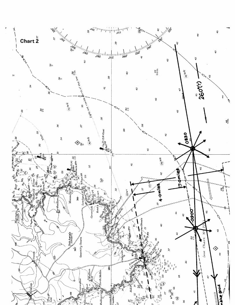
If this ship were to set in to the coast, or be forced, for some reason, to alter course to starboard, the course made good would obviously be other than 260° (T) — see Chart 2.
Were this to happen when parallel index plotting was in use then the deviation from the course to make good would appear on the radar as shown in Fig. iii. Lizard Point moves inside the plot - thus indicating that the ship is being set towards the shore. By setting the variable range marker on the parallel index line now passing through the Lizard it is seen that the ship has been set in 1 mile.
Thus parallel index plots of this kind enable a continuous watch to be kept on a vessel's track and will indicate the direction, and extent, of any deviations from the desired course.


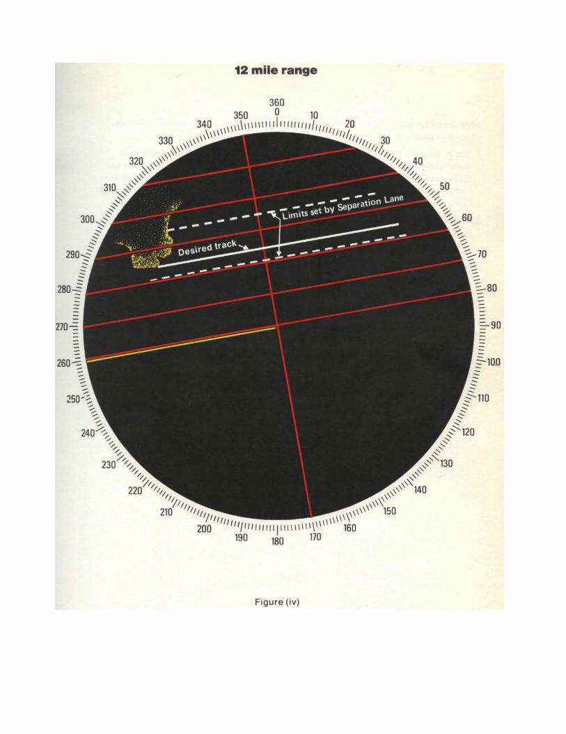
MARGINS OF SAFETY
Apart from indicating that a ship is deviating from a desired course the parallel index plots can be elaborated to show how far it is desirable or safe to deviate.
In the examples shown on Charts 1 and 2 it would be considered imprudent to venture outside the separation lane. It is possible to show the limits of the lane in conjunction with a plot of Lizard Point.
The desired passing distance is 5 miles, but a ship could pass at any distance between 4 and 7 miles without leaving the lane. Therefore, using the variable range marker and parallel bearing cursor in exactly the same way as shown above, two more parallel index plots could be drawn either side of the original plot from Lizard Point — one at 7 miles, the other at 4 miles. These would appear as shown in Fig. iv.
If now, for any reason, it is necessary to deviate from the desired course, an Officer, by watching Lizard Point on the radar has a quick and accurate check on whether or not the ship is approaching the edges of the lane.
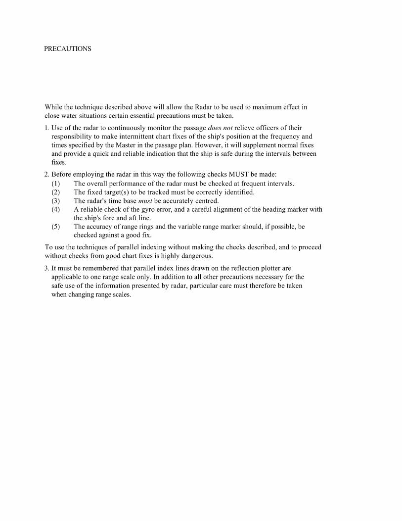
PRECAUTIONS
While the technique described above will allow the Radar to be used to maximum effect in close water situations certain essential precautions must be taken.
1. Use of the radar to continuously monitor the passage does not relieve officers of their responsibility to make intermittent chart fixes of the ship's position at the frequency and times specified by the Master in the passage plan. However, it will supplement normal fixes and provide a quick and reliable indication that the ship is safe during the intervals between fixes.
2. Before employing the radar in this way the following checks MUST be made:
(1) The overall performance of the radar must be checked at frequent intervals. (2) The fixed target(s) to be tracked must be correctly identified. (3) The radar's time base must be accurately centred. (4) A reliable check of the gyro error, and a careful alignment of the heading marker with
the ship's fore and aft line. (5) The accuracy of range rings and the variable range marker should, if possible, be
checked against a good fix.
To use the techniques of parallel indexing without making the checks described, and to proceed without checks from good chart fixes is highly dangerous.
3. It must be remembered that parallel index lines drawn on the reflection plotter are applicable to one range scale only. In addition to all other precautions necessary for the safe use of the information presented by radar, particular care must therefore be taken when changing range scales.

Annex II
A worked example of planning for a passage
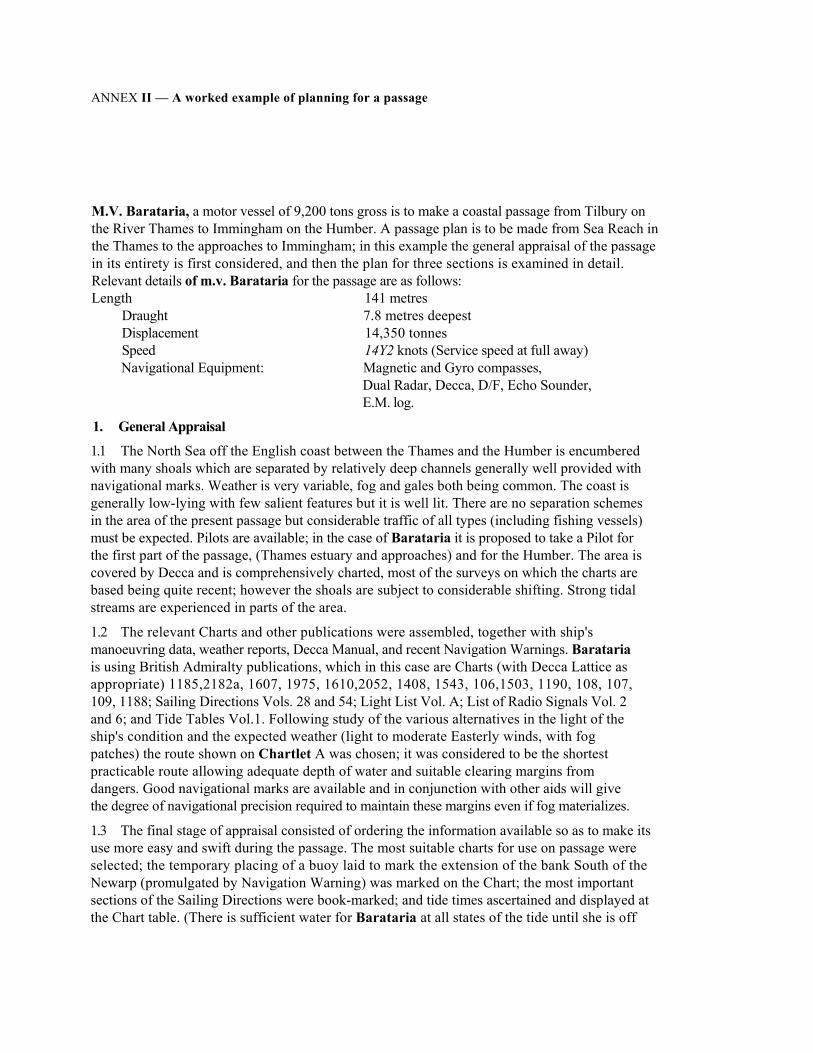
ANNEX II — A worked example of planning for a passage
M.V. Barataria, a motor vessel of 9,200 tons gross is to make a coastal passage from Tilbury on the River Thames to Immingham on the Humber. A passage plan is to be made from Sea Reach in the Thames to the approaches to Immingham; in this example the general appraisal of the passage in its entirety is first considered, and then the plan for three sections is examined in detail. Relevant details of m.v. Barataria for the passage are as follows: Length 141 metres
Draught 7.8 metres deepest Displacement 14,350 tonnes Speed 14Y2 knots (Service speed at full away) Navigational Equipment: Magnetic and Gyro compasses,
Dual Radar, Decca, D/F, Echo Sounder, E.M. log.
1. General Appraisal
1.1 The North Sea off the English coast between the Thames and the Humber is encumbered with many shoals which are separated by relatively deep channels generally well provided with navigational marks. Weather is very variable, fog and gales both being common. The coast is generally low-lying with few salient features but it is well lit. There are no separation schemes in the area of the present passage but considerable traffic of all types (including fishing vessels) must be expected. Pilots are available; in the case of Barataria it is proposed to take a Pilot for the first part of the passage, (Thames estuary and approaches) and for the Humber. The area is covered by Decca and is comprehensively charted, most of the surveys on which the charts are based being quite recent; however the shoals are subject to considerable shifting. Strong tidal streams are experienced in parts of the area.
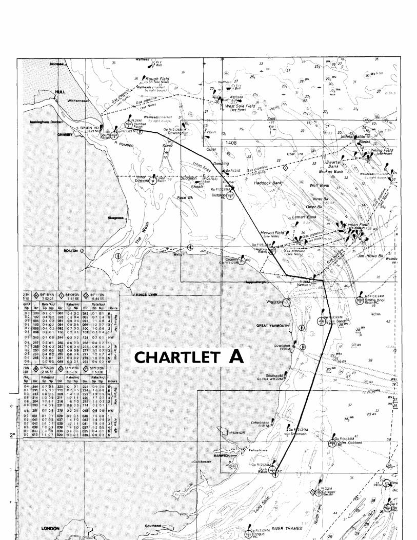
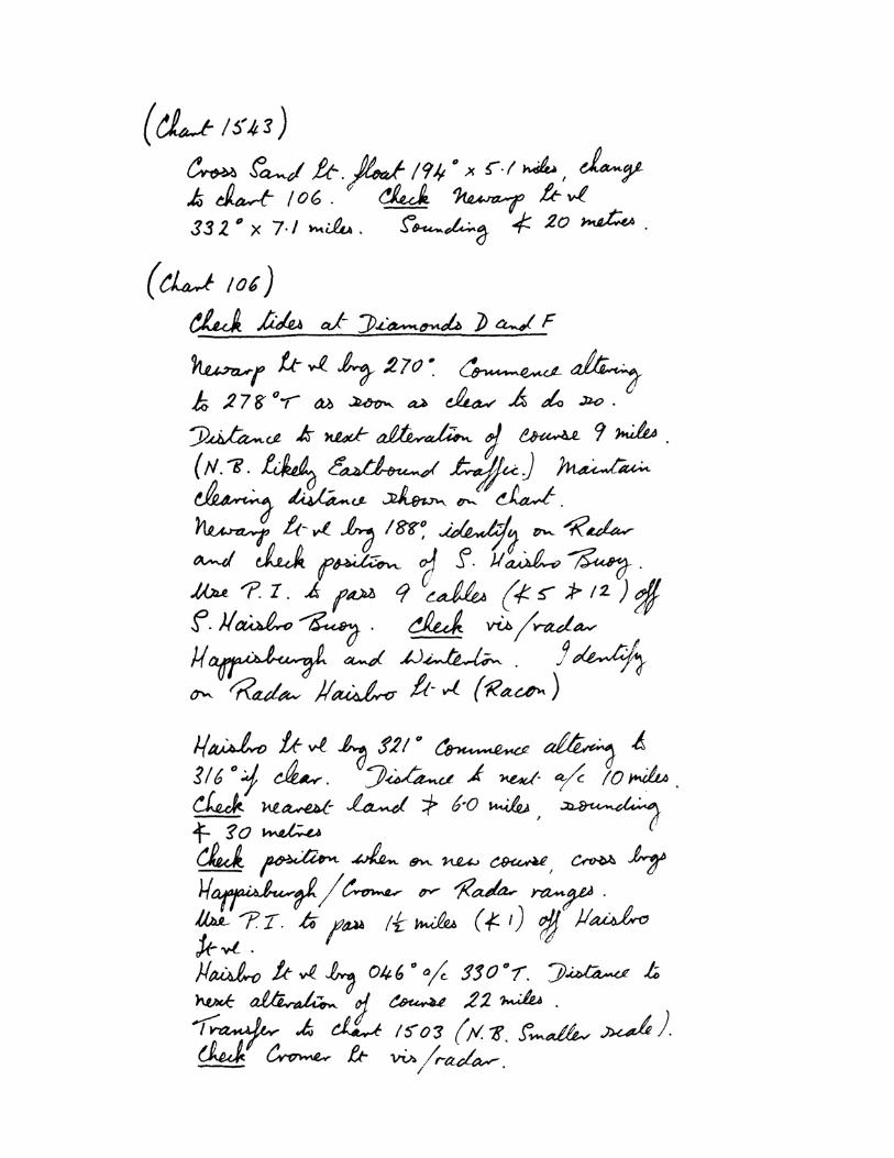
1.2 The relevant Charts and other publications were assembled, together with ship's manoeuvring data, weather reports, Decca Manual, and recent Navigation Warnings. Barataria is using British Admiralty publications, which in this case are Charts (with Decca Lattice as appropriate) 1185,2182a, 1607, 1975, 1610,2052, 1408, 1543, 106,1503, 1190, 108, 107, 109, 1188; Sailing Directions Vols. 28 and 54; Light List Vol. A; List of Radio Signals Vol. 2 and 6; and Tide Tables Vol.1. Following study of the various alternatives in the light of the ship's condition and the expected weather (light to moderate Easterly winds, with fog patches) the route shown on Chartlet A was chosen; it was considered to be the shortest practicable route allowing adequate depth of water and suitable clearing margins from dangers. Good navigational marks are available and in conjunction with other aids will give the degree of navigational precision required to maintain these margins even if fog materializes.
1.3 The final stage of appraisal consisted of ordering the information available so as to make its use more easy and swift during the passage. The most suitable charts for use on passage were selected; the temporary placing of a buoy laid to mark the extension of the bank South of the Newarp (promulgated by Navigation Warning) was marked on the Chart; the most important sections of the Sailing Directions were book-marked; and tide times ascertained and displayed at the Chart table. (There is sufficient water for Barataria at all states of the tide until she is off
Immingham, but the times will be necessary for estimating set and drift whilst on passage). Brief VHF/RT details - calling and listening channels and times - were also abstracted from the List of Radio Signals and displayed. Finally, approximate ETA's for Humber pilot and for Immingham were worked out.
It may be noted that, in the particular example chosen, the area is very well documented but the same principles should be followed as far as possible in all cases.
2. Planning
2.1 The next stage was to draw up the passage plan in detail, laying off the courses to be followed and noting on the Chart and in the bridge note-book other information required to execute the passage and facilitate its being properly monitored. This was done for the entire passage; the extracts given below are only parts of the whole chosen as examples to cover different aspects.
2.2 (Chartlet B) There are extensive banks between Smith's Knoll and Haisborough, and Chartlet B shows how it was planned to negotiate them, by using the Haisborough Gat and The Would. An extract from the bridge note-book to complement the Chart is also included.
(a) The transfer position to Chart 106 is noted, with a check bearing and distance to the first principal mark on the new chart, and a further sounding check;
(b) Course lines are laid off and limits of "acceptable deviation" at critical stages are marked with reference in the note-book at intervals. Standing Orders will make it clear that so far as practicable it is the Course line which is to be followed: the limits are drawn only to show the acceptable deviation due to manoeuvring or the degree of error unavoidable in position fixing;
(c) Alter course positions are shown as points on the chart. Since this is not entirely realistic, "Wheel over" positions in terms of a limiting bearing are noted in the book. Note that these bearings, and other planning data, where shown on the chart are kept well clear of the course line to avoid possible confusion on passage;
(d) Use of Parallel Indexing (PI) and of check bearings/ranges/soundings is noted as appropriate; the navigator has attempted to cover daylight and darkness, clear weather and fog, choosing as primary and secondary methods those he considers to be of greatest accuracy in the area;
(e) The banks cleared, it is best to transfer forthwith to the next chart. The note-book has a suitable note including a caution as to the change of scale.
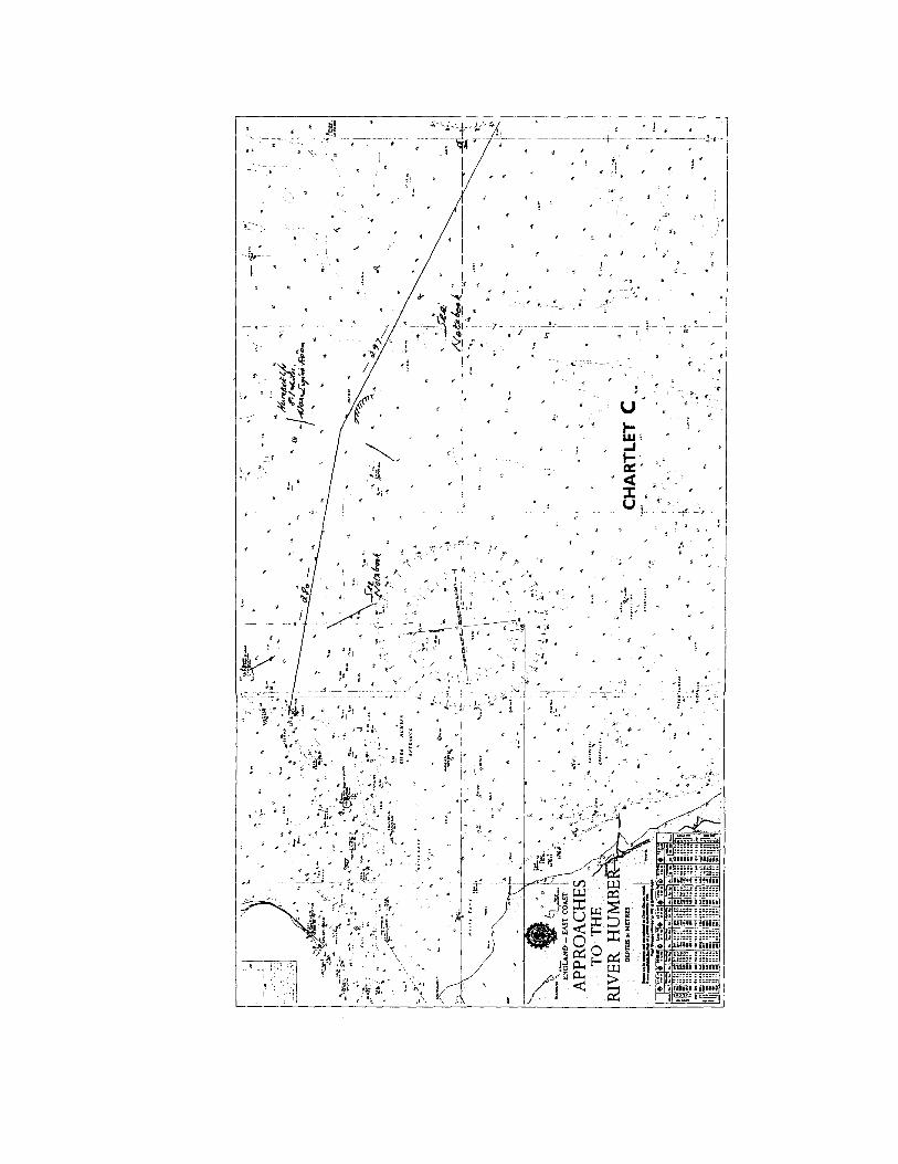
2.3 (Chartlet C) and the note-book extract appended with it show the first stage of the approach to the Humber. (a) The Navigator has noted the use of remarkable depth contours in checking the position,
and the need for Humber light-vessel to be positively identified; (b) The existence of a dangerous wreck near the course line is noted; (c) In this case, the alter course note refers to a bearing and a maximum range rather than
a limiting bearing , due to the relative positions of ship and mark.
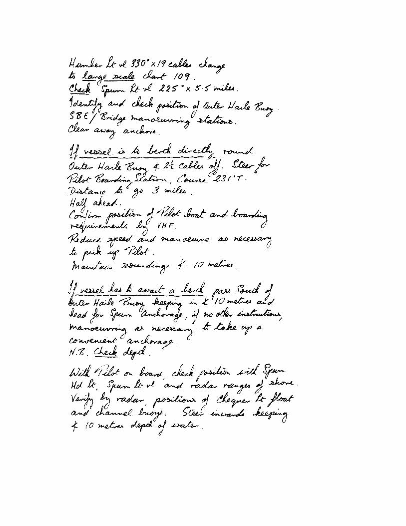
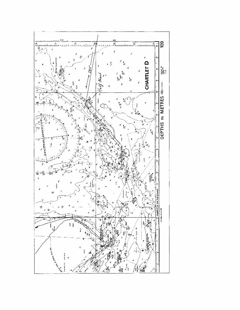
2.4 (Chartlet D) continues the approach and includes picking up the Pilot, or alternatively the approach to Spurn Anchorage should berthing not be possible on arrival. (a) At the earliest opportunity the change to the final approach chart is made, a check
position on the new chart being as always provided; (b) Positions for Stand By Engines; first movement; radio calls to Pilot; and "stations" for'd
and on the Bridge are noted; (c) As in the previous extract, buoys are used; this is in order provided their position is first
checked against a known mark; the need for this is emphasized in the note-book.

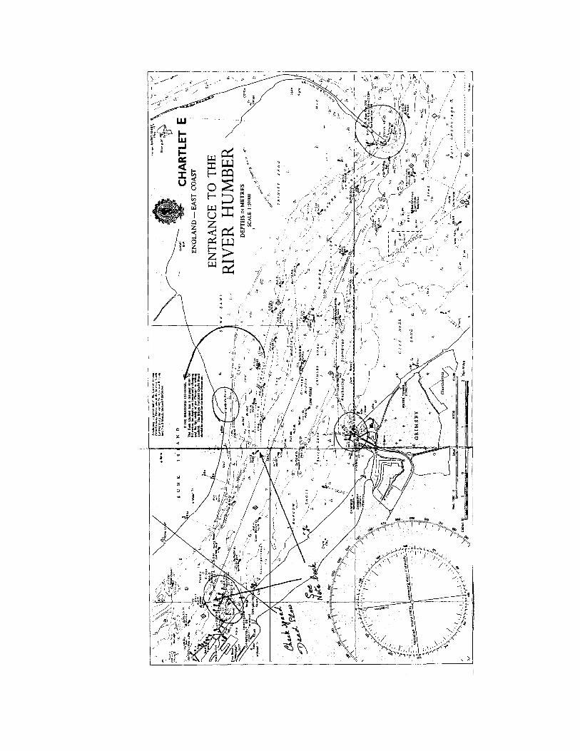
2.5 (Chartlet E) The passage up the Humber will be under pilotage and it was appreciated that a detailed plan could not be prepared for this as Sailing Directions warn that the banks are liable to shifting and Pilot's directions are therefore essential. However, progress must none the less be care- fully monitored and the note-book is prepared so as to assist in this.
(a) Shore landmarks for position Checking are included; (b) A mark (Immingham Jetty) is selected for checking approach speed by radar ranges; (c) A cautionary note as to speed passing moored tankers has been abstracted from the
Sailing Directions.
NB. The passage plan and associated information given are to illustrate the application of the text of this booklet only. Changes in navigational and other data may invalidate the plan.


Annex III Check list of items for passage appraisal
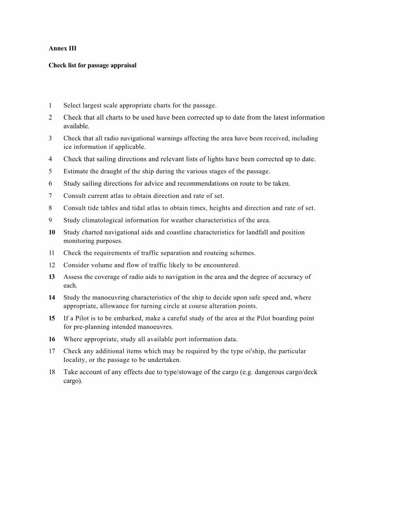
Annex III
Check list for passage appraisal
1 Select largest scale appropriate charts for the passage.
2 Check that all charts to be used have been corrected up to date from the latest information available.
3 Check that all radio navigational warnings affecting the area have been received, including ice information if applicable.
4 Check that sailing directions and relevant lists of lights have been corrected up to date.
5 Estimate the draught of the ship during the various stages of the passage.
6 Study sailing directions for advice and recommendations on route to be taken.
7 Consult current atlas to obtain direction and rate of set.
8 Consult tide tables and tidal atlas to obtain times, heights and direction and rate of set.
9 Study climatological information for weather characteristics of the area.
10 Study charted navigational aids and coastline characteristics for landfall and position monitoring purposes.
11 Check the requirements of traffic separation and routeing schemes.
12 Consider volume and flow of traffic likely to be encountered.
13 Assess the coverage of radio aids to navigation in the area and the degree of accuracy of each.
14 Study the manoeuvring characteristics of the ship to decide upon safe speed and, where appropriate, allowance for turning circle at course alteration points.
15 If a Pilot is to be embarked, make a careful study of the area at the Pilot boarding point for pre-planning intended manoeuvres.
16 Where appropriate, study all available port information data.
17 Check any additional items which may be required by the type oi'ship, the particular locality, or the passage to be undertaken.
18 Take account of any effects due to type/stowage of the cargo (e.g. dangerous cargo/deck cargo).