particle size distribution -...
TRANSCRIPT

Chapter 3¾Examination and Description of Soils SOIL SURVEY MANUAL 60
Soil Survey Division Staff - USDA Handbook No. 18. 1993
Particle Size Distribution This section discusses particle distribution. The finer sizes are called fine earth (smaller than 2 mm diameter) as distinct from rock fragments (pebbles, cobbles, stones, and boulders). Particle-size distribution of fine earth or less than 2 mm is determined in the field mainly by feel. The content of rock fragments is determined by estimating the proportion of the soil volume that they occupy.

Chapter 3¾Examination and Description of Soils SOIL SURVEY MANUAL 61
Soil Survey Division Staff - USDA Handbook No. 18. 1993
Soil Separates The United States Department of Agriculture uses the following size separates for the <2 mm mineral material:
Very coarse sand: 2.0-1.0 mm
Coarse sand: 1.0-0.5 mm Medium sand: 0.5-0.25 mm
Fine sand: 0.25-0.10 mm Very fine sand: 0.10-0.05 mm
Silt: 0.05-0.002 mm Clay: < 0.002 mm
Figure 3-14 compares the USDA system with others.
FIGURE 3-14
Relationships among particle size classes of 5 different systems.

Chapter 3¾Examination and Description of Soils SOIL SURVEY MANUAL 62
Soil Survey Division Staff - USDA Handbook No. 18. 1993
Figure 3-15 illustrates classes of soil particles larger than silt.
Soil Texture Soil texture refers to the weight proportion of the separates for particles less than 2 mm as determined from a laboratory particle-size distribution. Field estimates should be checked against laboratory determinations and the field criteria should be adjusted as necessary. Some soils are not dispersed completely in the standard particle size analysis. For these, the field texture is referred to as apparent because it is not an estimate of the results of a laboratory operation. Apparent field texture is a tactile evaluation only with no inference as to laboratory test results. Field criteria for estimating soil texture must be chosen to fit the soils of the area. Sand particles feel gritty and can be seen individually with the naked eye. Silt particles cannot be seen individually without magnification; they have a smooth feel to the fingers when dry or wet. In some places, clay soils are sticky; in others they are not. Soils dominated by montmorillonite clays, for example, feel different from soils that contain similar amounts of micaceous or kaolintic clay. Even locally, the relationships that are useful for judging texture of one kind of soil may not apply as well to another kind.
FIGURE 3-15
Sizes of particles of indicated diameters (d) in millimeters.

Chapter 3¾Examination and Description of Soils SOIL SURVEY MANUAL 63
Soil Survey Division Staff - USDA Handbook No. 18. 1993
The texture classes (fig. 3-16) are sand, loamy sands, sandy loams, loam, silt loam, silt, sandy clay loam, clay loam, silty clay loam, sandy clay, silty clay, and clay. Subclasses of sand are subdivided into coarse sand, sand, fine sand, and very fine sand. Subclasses of loamy sands and sandy loams that are based on sand size are named similarly.
Definitions of the soil texture classes follow:
Sands.—More than 85 percent sand, the percentage of silt plus 1.5 times the percentage of clay is less than 15.
Coarse sand. A total of 25 percent or more very coarse and coarse sand and less than 50 percent any other single grade of sand. Sand. A total of 25 percent or more very coarse, coarse, and medium sand, a total of less than 25 percent very coarse and coarse sand, and less than 50 percent fine sand and less than 50 percent very fine sand. Fine sand. 50 percent or more fine sand; or a total of less than 25 percent very coarse, coarse, and medium sand and less than 50 percent very fine sand. Very fine sand. 50 percent or more very fine sand.
FIGURE 3-16
Chart showing the percentages of clay, silt, and sand in the basic textural classes.

Chapter 3¾Examination and Description of Soils SOIL SURVEY MANUAL 64
Soil Survey Division Staff - USDA Handbook No. 18. 1993
Loamy sands.—Between 70 and 91 percent sand and the percentage of silt plus 1.5 times the percentage of clay is 15 or more; and the percentage of silt plus twice the percentage of clay is less than 30.
Loamy coarse sand. A total of 25 percent or more very coarse and coarse sand and less than 50 percent any other single grade of sand. Loamy sand. A total of 25 percent or more very coarse, coarse, and medium sand and a total of less than 25 percent very coarse and coarse sand, and less than 50 percent fine sand and less than 50 percent very fine sand. Loamy fine sand. 50 percent or more fine sand; or less than 50 percent very fine sand and a total of less than 25 percent very coarse, coarse, and medium sand. Loamy very fine sand. 50 percent or more very fine sand.
Sandy loams.—7 to 20 percent clay, more than 52 percent sand, and the percentage of silt plus twice the percentage of clay is 30 or more; or less than 7 percent clay, less than 50 percent silt, and more than 43 percent sand.
Coarse sandy loam. A total of 25 percent or more very coarse and coarse sand and less than 50 percent any other single grade of sand. Sandy loam. A total of 30 percent or more very coarse, coarse, and medium sand, but a total of less than 25 percent very coarse and coarse sand and less than 30 percent fine sand and less than 30 percent very fine sand; or a total of 15 percent or less very coarse, coarse, and medium sand, less than 30 percent fine sand and less than 30 percent very fine sand with a total of 40 percent or less fine and very fine sand. Fine sandy loam. 30 percent or more fine sand and less than 30 percent very fine sand; or a total of 15 to 30 percent very coarse, coarse, and medium sand; or a total of more than 40 percent fine and very fine sand, one half or more of which is fine sand, and a total of 15 percent or less very coarse, coarse, and medium sand. Very fine sandy loam. 30 percent or more very fine sand and a total of less than 15 percent very coarse, coarse, and medium sand; or more than 40 percent fine and very fine sand, more than one half of which is very fine sand, and total of less than 15 percent very coarse, coarse, and medium sand.
Loam.—7 to 27 percent clay, 28 to 50 percent silt, and 52 percent or less sand.
Silt loam. 50 percent or more silt and 12 to 27 percent clay, or 50 to 80 percent silt and less than 12 percent clay. Silt. 80 percent or more silt and less than 12 percent clay. Sandy clay loam. 20 to 35 percent clay, less than 28 percent silt, and more than 45 percent sand. Clay loam. 27 to 40 percent clay and more than 20 to 46 percent sand. Silty clay loam. 27 to 40 percent clay and 20 percent or less sand. Sandy clay. 35 percent or more clay and 45 percent or more sand. Silty clay. 40 percent or more clay and 40 percent or more silt.
Chapter 3¾Examination and Description of Soils SOIL SURVEY MANUAL 65
Soil Survey Division Staff - USDA Handbook No. 18. 1993
Clay. 40 percent or more clay, 45 percent or less sand, and less than 40 percent silt. The texture triangle (fig. 3-16) is used to resolve problems related to word definitions,
which are somewhat complicated. The eight distinctions in the sand and loamy sand groups provide refinement greater than can be consistently determined by field techniques. Only those distinctions that are significant to use and management and that can be consistently made in the field should be applied.
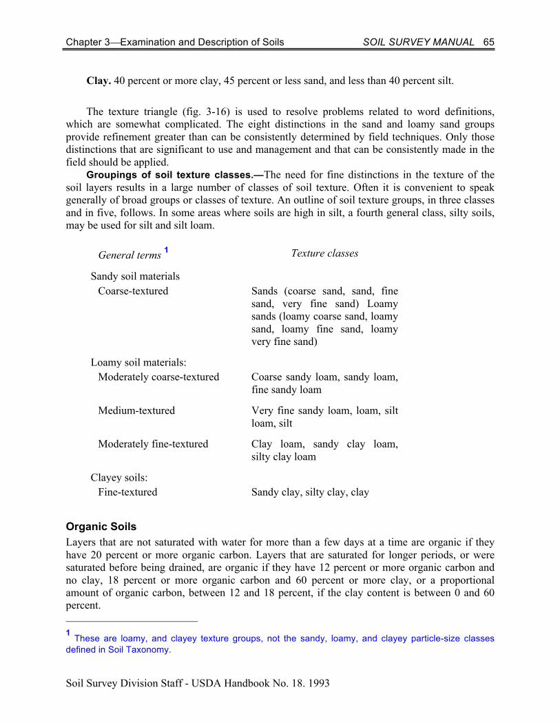
Groupings of soil texture classes.—The need for fine distinctions in the texture of the soil layers results in a large number of classes of soil texture. Often it is convenient to speak generally of broad groups or classes of texture. An outline of soil texture groups, in three classes and in five, follows. In some areas where soils are high in silt, a fourth general class, silty soils, may be used for silt and silt loam.
General terms 1 Texture classes
Sandy soil materials Coarse-textured Sands (coarse sand, sand, fine
sand, very fine sand) Loamy sands (loamy coarse sand, loamy sand, loamy fine sand, loamy very fine sand)
Loamy soil materials: Moderately coarse-textured Coarse sandy loam, sandy loam,
fine sandy loam
Medium-textured Very fine sandy loam, loam, silt loam, silt
Moderately fine-textured Clay loam, sandy clay loam, silty clay loam
Clayey soils: Fine-textured Sandy clay, silty clay, clay
Organic Soils Layers that are not saturated with water for more than a few days at a time are organic if they have 20 percent or more organic carbon. Layers that are saturated for longer periods, or were saturated before being drained, are organic if they have 12 percent or more organic carbon and no clay, 18 percent or more organic carbon and 60 percent or more clay, or a proportional amount of organic carbon, between 12 and 18 percent, if the clay content is between 0 and 60 percent. 1 These are loamy, and clayey texture groups, not the sandy, loamy, and clayey particle-size classes defined in Soil Taxonomy.

Chapter 3¾Examination and Description of Soils SOIL SURVEY MANUAL 66
Soil Survey Division Staff - USDA Handbook No. 18. 1993
The kind and amount of the mineral fraction, the kind of organisms from which the organic material was derived, and the state of decomposition affect the properties of the soil material. Descriptions include the percentage of undecomposed fibers and the solubility in sodium pyrophosphate of the humified material. A special effort is made to identify and estimate the volume occupied by sphagnum fibers, which have extraordinary high water retention characteristics. When squeezed firmly in the hand to remove as much water as possible, sphagnum fibers are lighter in color than fibers of hypnum and most other mosses.
Fragments of wood more than 2 cm across and so undecomposed that they cannot be crushed by the fingers when moist or wet are called "wood fragments." They are comparable to rock fragments in mineral soils and are described in a comparable manner.
Muck (sapric) is well-decomposed, organic soil material. Peat (fibric) is relatively undecomposed, organic material in which the original fibers constitute almost all of the material. Mucky peat (hemic) is material intermediate between muck and peat.
Rock Fragments Rock fragments are unattached pieces of rock 2 mm in diameter or larger that are strongly cemented or more resistant to rupture. Rock fragments include all sizes that have horizontal dimensions less than the size of a pedon.
Rock fragments are described by size, shape, and, for some, the kind of rock. The classes are pebbles, cobbles, channers, flagstones, stones, and boulders (table 3-11). If a size or range of sizes predominates, the class is modified, as for example: "fine pebbles," "cobbles 100 to 150 mm in diameter," "channers 25 to 50 mm in length."
Gravel is a collection of pebbles that have diameters ranging from 2 to 75 mm. The term is applied to the collection of pebbles in a soil layer with no implication of geological formalization. The terms "pebble" and "cobble" are usually restricted to rounded or subrounded fragments; however, they can be used to describe angular fragments if they are not flat. Words like chert, limestone, and shale refer to a kind of rock, not a piece of rock. The composition of the fragments can be given: "chert pebbles," "limestone channers." The upper size of gravel is 3 inches (75 mm). This coincides with the upper limit used by many engineers for grain-size distribution computations. The 5-mm and 20-mm divisions for the separation of fine, medium, and coarse gravel coincide with the sizes of openings in the "number 4" screen (4.76 mm) and the "3/4 inch" screen (19.05 mm) used in engineering.
The 75 mm (3 inch) limit separates gravel from cobbles. The 250-mm (10-inch) limit separates cobbles from stones, and the 600-mm (24-inch) limit separates stones from boulders. The 150-mm (channers) and 380 mm (flagstones) limits for thin, flat fragments follow conventions used for many years to provide class limits for plate-shaped and crudely spherical rock fragments that have about the same soil use implications as the 250-mm limit for spherical shapes.
Rock Fragments in the Soil Historically, the total volume of rock fragments of all sizes has been used to form classes. The interpretations program imposes requirements that cannot be met by grouping all sizes of rock fragments together. Furthermore, the interpretations program requires weight rather than volume estimates. For interpretations, the weight percent >250, 75-250, 5-75 and 2-5 mm are required; the first two are on a whole soil basis, and the latter two are on a <75 mm basis. For the >250

Chapter 3¾Examination and Description of Soils SOIL SURVEY MANUAL 67
Soil Survey Division Staff - USDA Handbook No. 18. 1993
and 75-250 mm, weighing is generally impracticable. Volume percentage estimates would be made from areal percentage measurements by point-count or line-intersect methods. Length of the transect or area of the exposure should be 50 and preferably 100 times the area or dimensions of the rock fragment size that encompasses about 90 percent of the rock fragment volume. For the <75 mm weight, measurements are feasible but may require 50-60 kg of sample if appreciable rock fragments near 75 mm are present. An alternative is to obtain volume estimates for the 20-75 mm and weight estimates for the <20 mm. This is favored because of the difficulty in visual evaluation of the 2 to 5 mm size separations. The weight percentages of 5-20 and 2-5 mm may be converted to volume estimates and placed on a <75 mm base by computation. The adjectival form of a class name of rock fragments (table 3-11) is used as a modifier of the textural class name: "gravelly loam," "stony loam."
Table 3-11. Terms for rock fragments
Shape and size1 Noun Adjective
Spherical, cubelike, or equiaxial:
2-75 mm diameter Pebbles Gravelly 2-5 mm diameter Fine Fine gravelly 5-20 mm diameter Medium Medium gravelly 20-75 mm diameter Coarse Coarse gravelly
75-250 mm diameter Cobbles Cobbly. 250-600 mm diameter Stones Stony. >600 mm diameter Boulders Bouldery. Flat: 2-150 mm long Channers Channery. 150-380 mm long Flagstones Flaggy. 380-600 mm long Stones Stony. >600 mm long Boulders Bouldery. 1The roundness of the fragments may be indicated as angular (strongly developed faces with sharp edges), irregular (prominent flat faces with incipient rounding or corners), subrounded (detectable flat faces with well-rounded corners), and rounded (flat faces absent or nearly absent with all corners.
Chapter 3¾Examination and Description of Soils SOIL SURVEY MANUAL 68
Soil Survey Division Staff - USDA Handbook No. 18. 1993
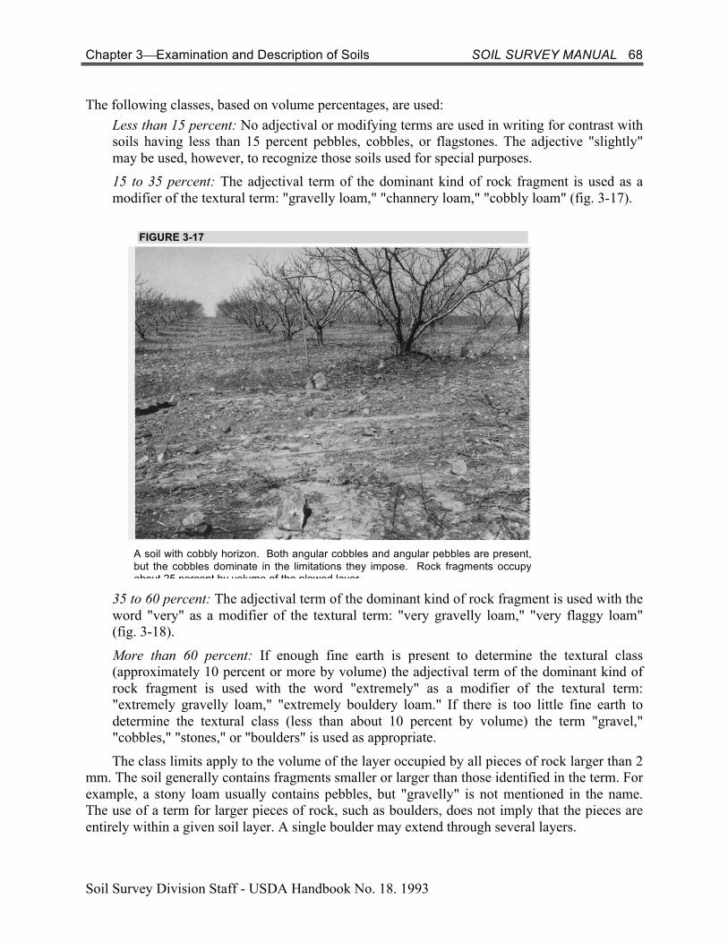
The following classes, based on volume percentages, are used: Less than 15 percent: No adjectival or modifying terms are used in writing for contrast with soils having less than 15 percent pebbles, cobbles, or flagstones. The adjective "slightly" may be used, however, to recognize those soils used for special purposes. 15 to 35 percent: The adjectival term of the dominant kind of rock fragment is used as a modifier of the textural term: "gravelly loam," "channery loam," "cobbly loam" (fig. 3-17).
35 to 60 percent: The adjectival term of the dominant kind of rock fragment is used with the word "very" as a modifier of the textural term: "very gravelly loam," "very flaggy loam" (fig. 3-18).
More than 60 percent: If enough fine earth is present to determine the textural class (approximately 10 percent or more by volume) the adjectival term of the dominant kind of rock fragment is used with the word "extremely" as a modifier of the textural term: "extremely gravelly loam," "extremely bouldery loam." If there is too little fine earth to determine the textural class (less than about 10 percent by volume) the term "gravel," "cobbles," "stones," or "boulders" is used as appropriate.
The class limits apply to the volume of the layer occupied by all pieces of rock larger than 2 mm. The soil generally contains fragments smaller or larger than those identified in the term. For example, a stony loam usually contains pebbles, but "gravelly" is not mentioned in the name. The use of a term for larger pieces of rock, such as boulders, does not imply that the pieces are entirely within a given soil layer. A single boulder may extend through several layers.
FIGURE 3-17
A soil with cobbly horizon. Both angular cobbles and angular pebbles are present, but the cobbles dominate in the limitations they impose. Rock fragments occupy about 25 percent by volume of the plowed layer.

Chapter 3¾Examination and Description of Soils SOIL SURVEY MANUAL 69
Soil Survey Division Staff - USDA Handbook No. 18. 1993
More precise estimates of the amounts of rock fragments than are provided by the defined classes are needed for some purposes. If the more precise information is needed, estimates of percentages of each size class or a combination of size classes are included in the description: "very cobbly loam; 30 percent cobbles and 15 percent gravel" or "silt loam; about 10 percent gravel." If loose pieces of rock are significant in use and management of a soil, they are the basis of phase distinctions among map units. Exposed bedrock is not soil and is separately identified in mapping.
The volume occupied by individual pieces of rock can be seen and their aggregate volume percentage can be calculated. For some purposes, volume percentage must be converted to weight percentage.
Rock Fragments at the Surface The treatment of gravel, cobbles and channers (2-250 mm) differs from that for stones and boulders (>250 mm).2 The reason for the difference is that an important aspect of the description of the 2-250 mm is the areal percent cover on the ground surface afforded by the rock fragments. For the >250 mm, the percent of cover is not of itself as important as the interference with mechanical manipulation of the soil. A very small areal percentage of large rock fragments, insignificant for erosion protection, may interfere with tillage.
The areal percentage over the ground surface is determined using point-count and/or line-intersect procedures. If the areal percentage exceeds 80 percent, the top of the soil is the mean height of the top of the rock fragments. The volume proportions of 2 to 5 mm, 5 to 75 mm, and 75 to 250 mm should be recorded. This can be done from areal measurements.
The number, size, and spacing of stones and boulders (>250 mm) on the surface of a soil, including both those that lie on the surface and those that are partly within the soil but protrude 2 These terms are defined in table 3-11.
FIGURE 3-18
A soil with a very cobbly surface horizon. Rock fragments occupy about 40 percent of the plowed layer and are concentrated on the surface.

Chapter 3¾Examination and Description of Soils SOIL SURVEY MANUAL 70
Soil Survey Division Staff - USDA Handbook No. 18. 1993
above ground, have important effects on soil use and management. The class limits that follow are given in terms of the approximate amount of stones and boulders at the surface.
Class 1. Stones or boulders cover about 0.01 to 0.1 percent of the surface. Stones of the smallest sizes are at least 8 m apart; boulders of the smallest sizes are at least 20 m apart (fig. 3-19). Class 2. Stones or boulders cover about 0.1 to 3 percent of the surface. Stones of the smallest sizes are not less than 1 m apart; boulders of the smallest size are no less than 3 m apart.
Class 3. Stones or boulders cover about 3 to 15 percent of the surface. Stones of the smallest size are as little as 0.5 m apart; boulders of the smallest size are as little as 1 m apart (fig. 3-21). Class 4. Stones or boulders cover about 15 to 50 percent of the surface. Stones of the smallest size are as little as 0.3 m apart; boulders of the smallest size are as little as 0.5 m apart. In most places it is possible to step from stone to stone or jump from boulder to boulder without touching the soil (fig. 3-22). Class 5. Stones or boulders appear to be nearly continuous and cover 50 to 90 percent of the surface. Stones of the smallest size are less than 0.03 m apart; boulders of the smallest size are less than 0.05 m apart. Classifiable soil is among the rock fragments, and plants can grow if not otherwise limited (fig. 3-23). These limits are intended only as guides to amounts that may mark critical limitations for major kinds of land use. Table 3-12 is a summary of the classes.
Table 3-12. Classes of surface stones and boulders in terms of cover and spacing
Class Percentage of surface covered
Distance in meters between stones or boulders if the diameter is:
0.25 m1 0.6 m 1.2 m Name 1 0.01-0.1 >8 >20 >37 Stony or bouldery
2 0.1-3.0 1-8 3-20 6-37 Very stony or very bouldery
3 3.0-15 0.5-1 1-3 2-6 Extremely stony or extremely bouldery
4 15-50 0.3-0.5 0.5-1 1-2 Rubbly
5 50-90 <0.3 <0.5 <1 Very Rubbly
1 0.38 m if flat.

Chapter 3¾Examination and Description of Soils SOIL SURVEY MANUAL 71
Soil Survey Division Staff - USDA Handbook No. 18. 1993
FIGURE 3-19
An area of bouldery soil (class 1).
FIGURE 3-20
An area of very bouldery soil (class 2).

Chapter 3¾Examination and Description of Soils SOIL SURVEY MANUAL 72
Soil Survey Division Staff - USDA Handbook No. 18. 1993
FIGURE 3-21
An area of extremely bouldery soil (class 3).
FIGURE 3-22
An area of rubbly soil (class 4).

Chapter 3¾Examination and Description of Soils SOIL SURVEY MANUAL 73
Soil Survey Division Staff - USDA Handbook No. 18. 1993