participatory reforestation plan manual - profor reforestation plan manual (final...1.2.3....
TRANSCRIPT
PROFOR PROGRAM
IN COLLABORATION WITH
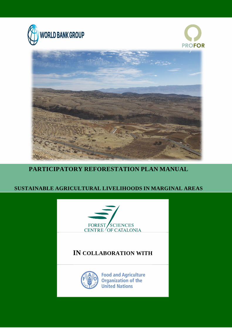
PARTICIPATORY REFORESTATION PLAN MANUAL
SUSTAINABLE AGRICULTURAL LIVELIHOODS IN MARGINAL AREAS


TABLE OF CONTENTS
AUTHORS ii ABBREVIATIONS iii PREFACE iv 1. Background context 1
1.1. National Afforestation & Reforestation Program: Roadmap 2030 1 1.2. Sustainable Agricultural Livelihoods in Rural Areas Project 1
1.2.1. Guidelines for Participatory Reforestation 2 1.2.2. Project Operation Manual to Implement Participatory Reforestation 2 1.2.3. Participatory Reforestation Plan Manual 2
2. Preparation stages of the Participatory Reforestation Plan 3
Stage 1: Validation and scoping workshop 5
Stage 2: Site & stakeholders diagnosis 7
Stage 3: Decision making process 10
Stage 4: Elaborate Reforestation Plan Components 14
Stage 5: Evaluation and Approval of the Participatory Reforestation Plan 15 Annex 1: Forms of the preparatory stages 16 Annex 2: Example of the methodology 31 Annex 3: Community Appraisal Tools 34 Annex 4: Participatory Reforestation Plan Template 43

AUTHORS
Iria SOTO is a Technician/Researcher at the Forest Sciences Centre of Catalonia (CTFC), she is a Forest Engineer and holds a MSc in Biological Sciences, Masters in International Cooperation and currently she is preparing a Doctorate in Bioeconomics. She has broad experience on participatory process and designing participatory methodologies for Natural Resources Management. Contact: [email protected] Jaime COELLO is a forest engineer & researcher at the Forest Sciences Centre of Catalonia (CTFC), holding a MSc in European Forestry. His main field of work is forest restoration in Mediterranean conditions, focused on the development of cost-effective techniques and management schemes. He has also relevant experience on silviculture and forest management and policy. Contact: [email protected] Jim CARLE Takayuki HAGIWARA (FAO Investment Centre)
CONTRIBUTORS
David SOLANO (Forest Science Centre of Catalonia-CTFC) Miriam PIQUE (Forest Science Centre of Catalonia-CTFC) Patricia SFEIR (Forest Science Centre of Catalonia-CTFC) Berna KARAM (Seeds-Int)
FUNDING
The report was funded under the World Bank Forest Program (PROFOR TF013957, Lebanon: Best Fit Practices for Reforestation to Enhance Climate Resilience in Remote Hilly Areas.

ABBREVIATIONS
DRDNR Directorate of Rural Development and Natural Resources in the MoA
EPI Expression of Participation Interest
FAO The Food and Agriculture Organization of the United Nations
GIS Geographic Information Systems
GoL Government of Lebanon
GPR Guidelines for Participatory Reforestation
GPS Global Positioning System
M&E Monitoring and Evaluation
MoA Ministry of Agriculture
MoU Memorandum of Understanding
NARP National Afforestation and Reforestation Plan
NGO Non-Governmental Organization
NTFP Non-Timber Forest Products
PMU Project Management Unit
POM Project Operational Manual
PRP Participatory Reforestation Plan
PRPM Participatory Reforestation Plan Manual
R&D Research and Development
RIU Reforestation Implementation Unit
SALMA Sustainable Agriculture and Livelihoods in Marginal Areas Project

PREFACE
The purpose of this Participatory Reforestation Plan Manual (PRPM) is to provide the stages, framework and format for consortium partners to prepare a Participatory Reforestation Plan (PRP) within the Sustainable Agricultural Livelihoods in Rural Areas (SALMA) Project in Lebanon. The stages of the preparation process are designed to encourage consortium partners to adopt participatory approaches and use participatory rural appraisal tools with the aim of including the needs and aspirations of communities and special interest groups. Additionally the PRPM provides a consistent and concise framework for detailing reforestation and livelihoods activities, methods and maps for ease of planning, implementation, monitoring and reporting. The PRPM draws upon, complements and supplements the Guidelines for Participatory Reforestation (GPR) and the Project Operation Manual (POM) for implementing the reforestation component of the SALMA Project. This PFPM has been prepared after extensive consultation with the Government, Municipalities, Non-governmental Organizations and other stakeholder groups that requested a simple, practical and transparent framework for preparation, implementation and monitoring of PRPs. The Annexes provide a series of tools, examples and templates for preparing and submitting the PRP. Technical and financial support will be available to prepare PRP and to pilot test them in the SALMA Project areas in different institutional, social, environmental and economic settings in the project reforestation sites in the field. The draft PRPM will be revised to incorporate feedback from field testing and from stakeholders. The PRPM will assist the Ministry of Agriculture (MoA), the Directorate of Rural Development and Natural Resources (DRDNR), the Forest Service, Municipalities, Non-governmental Organizations (NGOs) and other consortium partners in preparing and implementing PRPs within the SALMA Project and within other ongoing or future reforestation initiatives in Lebanon.

1
1. Background context
1.1. National Afforestation & Reforestation Program: Roadmap 2030 In 2010, the planted forest area in Lebanon was reported as 10,500 hectares, despite planting being undertaken since the 1960’s. In 2013, the Government of Lebanon (GoL) approved the National Afforestation and Reforestation Program: Roadmap 2030 (NARP) to increase the 137,000 hectares of forest by planting 70,000 hectares to expand the forest cover from about 13% to 20% land cover by 2030. The aim is to strengthen ecological and community resilience to climate change and socio-economic pressures by adopting approaches that will: i) facilitate participation of key stakeholder groups (including local communities) in planning and implementation; ii) combine traditional and scientific knowledge; iii) integrate watershed management and landscape methods; iv) strengthen adaptation to climate change; v) protect and conserve indigenous forests and species; and vi) enhance social and cultural values. The reforestation priorities are to improve participatory approaches, genetic stock, seedling quality, nursery practices, site preparation, planting, tending, silviculture, maintenance and forest protection to increase tree survival, growth and vitality; reduce work norms and costs and provide more social, environmental and economic benefits of planted forests.
1.2. Sustainable Agricultural Livelihoods in Rural Areas Project The World Bank, Global Environment Facility (GEF) and the GoL are partners in the Sustainable Agricultural Livelihoods in Marginal Areas (SALMA) Project to construct hill reservoirs, on-farm irrigation systems and rural roads to access markets and expand reforestation to restore degraded forest landscapes. Some of the poorest communities and most fragile ecosystems will be targeted to strengthen their resilience to climate change. The project aims to plant one million trees as a first pilot phase in supporting implementation of the NARP to protect erosion prone soils, watersheds, biodiversity, agriculture and communities from climate change. The reforestation component of the project will finance improved seeds, seedling production, site preparation, planting, tending, silviculture and protection of 2,000 hectares of reforestation on selected pilot sites on State or municipal lands. Building upon lessons learned from past reforestation experience, the project will provide technical support to strengthen the capacity of the Ministry of Agriculture (MoA), municipalities, Non-Governmental Organizations (NGOs), private sector and local communities to adopt more integrated, participatory approaches in the planning, financing, mobilizing and monitoring implementation of the reforestation and livelihoods support processes. The aim is to increase stakeholder understanding, ownership and commitment to the planning, implementation and monitoring processes. There are three inter-related documents for preparation and implementation of reforestation within the SALMA Project:
- Guidelines for Participatory Reforestation (GPR) - Project Operation Manual for the Reforestation Component (POM) - Participatory Reforestation Plan Manual (PRPM)

2
1.2.1. Guidelines for Participatory Reforestation
The Guidelines for Participatory Reforestation (GPR) provide a frame of principles and environmental and social best practices and recommended actions that need to be adopted to achieve greater community participation, restore forest landscapes and adopt more active maintenance, protection and management in reforestation. Additionally the Guidelines encourage consortium partners to improve work norms, reduce operating costs and enhance benefits to local communities and rural livelihoods. 1.2.2. Project Operation Manual to Implement Participatory Reforestation
The Project Operation Manual (POM) provides the project implementation strategy and approach, describes the institutional setting of the project, guides establishment of consortium partners, summarizes grant funding and implementation modalities, details implementation phases and steps and provides the formats for the submission of expressions of participation interest, concept notes and site validation for pre-selection of consortium partners and sites, prior to preparation of a PRP. 1.2.3. Participatory Reforestation Plan Manual
This Participatory Reforestation Plan Manual (PRPM) provides the stages, framework and format for consortium partners to prepare, implement and report on a PRP on specific sites in selected communities within the SALMA Project. Additionally this document provides a consistent and concise framework for detailing the 4 main components of the reforestation plan:
- Technical reforestation Plan: activities to implement the reforestation according to the selected Reforestation Scheme.
- Livelihoods support Plan: activities that will support the success of the reforestation actions: i) mitigation measures against the identified threats (e.g. improvement of grazing areas out of the reforested sites) and ii) potential activities that reforestation supporters can perform to increase the success of the reforestation by generating synergies.
- Research & Development Plan: it is voluntary, and includes the R&D activities to be conducted by University and Research Centers within the reforested area, with the aim of generating know-how leading to enhanced future reforestations.
- Monitoring and evaluation Plan: methods for reporting of reforestation activities status and follow up.
This document facilitates the preparation process of the PRP by including in all the Forms needed during the elaboration of the Plan (Annex 1). Annex 2 of the document includes an example of the methodology used to characterize the reforestation sites. The PRPM encourages consortium partners to adopt participatory approaches and use participatory rural appraisal tools to include the needs and aspirations of communities and special interest groups. A toolbox of participatory approaches is presented in Annex 3. Finally, the template of the Participatory Reforestation Plan, including the different sections that might be included in the Plan is presented in Annex 4.

3
2. Preparation stages of the Participatory Reforestation Plan
Preparation of the Participatory Reforestation Plan (PRP) is undertaken after an Orientation Workshop, submission of an Expression of Participation Interest (EPI) and approval of a Concept Note (detailed in the POM) that provides preliminary information about consortium partners, reforestation and livelihoods support proposals. The SALMA Project will provide grant funding of $100/hectare, up to a maximum of $10,000, to assist in the preparation of a PRP process. Furthermore, technical support will be available from the Reforestation Implementation Unit (RIU) of the Project Management Unit (PMU) to address preparation, implementation and monitoring issues. The different stages that shape the preparation of the Participatory Reforestation Plan are showed in the following figure (light green). They are linked to the different steps of the whole reforestation process (explained at the POM document), which includes preparation, implementation and monitoring and evaluation (dark green). These different stages explain the process for the preparation of the Participatory Reforestation Plan. The information gathered in each stage shall be included in the Participatory Reforestation Plan as indicates the PRPM Template (Annex 4). The following section outlines and describes the stages for the preparation and approval of a Participatory Reforestation Plan.

4
Figure 1: Steps and stages of the Participatory Reforestation Plan
STAGE 1: VALIDATION AND SCOPING WORKSHOP
STEP4: Participatory Reforestation Plan Preparation
STEP3: Concept Notes (Preparation and Evaluation)
STEP2: Expression of Participation Interest (Submission & Evaluation)
STEP1: Regional WORKSHOP (Municipalities & Reforestation Partners)
STAGE 2: SITE & SOCIO-ECONOMIC DIAGNOSIS
STAGE 4: ELABORATION OF THE PARTICIPATORY
REFORESTATION PLAN (PRP)
STAGE 3: DECISION MAKING
STAGE 5: EVALUATION AND APPROVAL OF PRP
STEP6: Monitoring, evaluation
and Reporting
STEP5: Implementation of the
Participatory Reforestation Plan

5
STAGE 1: VALIDATION AND SCOPING WORKSHOP Who participates?
On approval of the Concept Note, consortium members need to convene a meeting/workshop with the municipality representative, the municipality Environmental Committee1 and the Reforestation Partners (RPs). Which are the objectives of the workshop?
1. Joint review of the Participatory Reforestation Plan Manual (PRPM) and the Project
Operation Manual (POM) to solve doubts and have a common view of the work that needs to be done.
2. Plan the preparatory process (defining working plan, formalizing the roles of
consortium partners and estimating budget for each partner and activity). 3. Identification of the needs of technical support to strengthen Reforestation Consortium
(RC) capacity to prepare and implement the PRP. 4. Identification of the Municipality land that can potentially be reforested or afforested. How the workshops can be performed?
The work can be conducted during a 1-2 days meeting, held at the Municipality council or other available meeting facilities found at the Municipality. The working documents that will be needed during the meeting are the following:
Last version of the PRPM and POM (which should be sent in advance to participants).
The electronic copy of the cadastral map and the official registration document showing the land ownership of the municipality lands suitable for reforestation.
A permit of the Ministry of Finance (if the land to be reforested belongs to the state).
Form 1: Work-plan for PRP preparation (Annex 1), by using Tool 1: Work plan & Budget if needed.
Form 2: Budget (Annex 1).
Form 3: Identification of reforestation consortium needs of technical support (Annex 1).
Cadastral map with a preliminary selection of the areas to be reforested (already included in the Concept Note) and assignation of potentially desirable uses (Form 4: Preliminary characterization of the zones to be reforested).
1 If there is not Environmental Committee in the Municipality, the first step is to form one following the procedure of each Municipality. Alternative, the Major can designate 2-3 persons from the Board of the Municipality that will acts as Environmental Committee.

6
Which are the outputs?
Minutes of the meeting with deadlines and responsibilities of each partner.
Work-plan including the responsibilities of each partner, time-line (with deadlines) and budget for each activity and budget (Form 1 and 2 completed).
Identification of the technical support needed to be requested to the PMU/RIU (Ministry of Agriculture) (Form 3 completed).
Preliminary assignation of the compartments to be reforested (Cadastral map with the preliminary selected reforestation areas and potential desirable uses and Form 4).

7
STAGE 2: SITE & STAKEHOLDERS DIAGNOSIS Who participates?
The Environmental Committee of the Municipality, with the support of the Reforestation Partners will lead the process. For the site-environmental diagnostic, they might consider consulting further Public institutions (e. g. Ministry of Agriculture), Universities and Research Centers to obtain the needed environmental data that might be absent at municipality level. For the stakeholders’ diagnosis, RC should involve all the population that uses the land to be reforested (e.g. shepherds), in order to integrate their needs into the reforestation and livelihoods support plans. RC should also promote the participation of all the stakeholders (e.g. public institution, private companies, civil society organizations, NGOs, environmental, women, youth associations, producer organizations, Universities & research centers) and sectors of the population interested in supporting the reforestation process. Which are the objectives?
1. Identification of all the stakeholders that can be involved on the participatory reforestation (i.e. land users and reforestation supporters), inform them about the reforestation process and enhance their participation
2. Identification and evaluation of previous reforestation experiences to learn from past
successes and failures (e. g. reforestation techniques, suitable species) 3. Localization of livestock activities (and other major constraints or factors conditioning
reforestation) 4. Zoning of the area to reforest into homogeneous Patches, subsequently aggregated into
Reforestation Blocks, which will be the base for reforestation planning How the diagnosis is done?
1. Identification of stakeholders
Reforestation stakeholders are divided in two main groups: land users and reforestation supporters.
Stakeholders Description
Land users They are the population that might be affected by the reforestation (e.g. shepherds, non timber forest products harvesters)
Reforestation supporters
They are the individual or organization entities that can provide support during the reforestation implementation and monitoring process. They can support the reforestation by implementing synergetic activities to reinforce the ownership, visibility and raise awareness of community members towards the reforestation.
Form 5a: Stakeholders group information (Land users) and Form 5b: Stakeholders group information (Reforestation supporters) (Annex 1) provides key information that should be gathered to characterize each stakeholder. When possible, the identification of stakeholders should be done with Municipality representatives by talks, meetings or discussions with stakeholders that are affected or interested in

8
participate in the process. However, in case that the identification of stakeholders is not clear or complete enough the Tool 2: Stakeholder’s mapping (Annex 3) might support their identification. 2. Identification of previous reforestation experiences
This information can be gathered by interviewing or organizing discussions with: i) The institution that implements the reforestation; ii) Municipality leaders; iii) Other actors that might have a remarkable knowledge on previous reforestation activities. Form 6: Previous reforestation experience at Municipality level provides a guide with the information to be gathered and Annex 3 the tools that can be used (e.g. Tool 3: Interview and Tool 4: Focus groups & workshops). 3. Localization of livestock activities (and other major constraints conditioning the reforestation)
It is extremely important to identify shepherds activities and the grazing patterns of the livestock as well as other mayor constrains that can limit the success of the reforestation. This will help us in discriminating the areas that, due to latent conflicts, can not be potentially reforested. It will also allow the identification of areas that can be reforested if mitigation measures (economically and technically feasible) are applied. Additionally to livestock activities, other major constrains (e.g. protected areas, areas devoted to social, cultural or religious purposes that should remain non-reforested, exclusion areas for security reasons), if existing, will be identified in order to either identify mitigation measures or to exclude them from the Reforestation. The Form 7: Livestock activities characterization might support the identification of the different types of shepherds’ activities. A workshop with shepherds will be organized to identify grazing partners (both temporal and spatial). The Tool 5: Participatory rangeland mapping can be used to identify the livestock patterns and activities. When the shepherds can not participate in discussion meetings (e. g transhumant from other regions), discussions with experts that know the situation will be held in order to identify the zones to be excluded and discriminate them from the reforestation by using the same approach. 4. Zoning of the areas to be reforested (compartments, Patches and blocks)
This activity is firstly based on the outcomes of the validation workshop and of the stakeholders diagnosis, which are applied to the Cadastral map showing the compartments available for reforestation. After dismissing those compartments or parts of the compartments which have been identified as hosting a conflict that cannot be solved through mitigation measures (i.e. high interest grazing areas), the remaining compartments, numbered from 1 to n, are characterized and zoned based on data collected at both Municipality and Reforestation Patch level: i) Municipality data refer to the variables which are common to all the compartments that will be reforested in the Municipality (e.g. climate, bioclimate, general soil features, species present in the area and surrounding areas). This process is performed at the office. These variables will be considered when designing the reforestation activities. The element filled in this phase is Form 8: Site diagnosis at Municipal Level (Annex 1). ii) Reforestation Patch data refers to those features that allow the identification and delimitation of ecologically homogeneous Patches. The whole area of each Patch will be subjected to a particular reforestation purpose in the future. This delimitation is done in two phases: a preliminary one taking place at the office and based on GIS and satellite images: a first zoning is done based on slope,

9
physiography, aspect, spontaneous shrub / tree cover, etc, resulting in a cartography of the area with the preliminary zoning. The second phase, taking place in the field and with the help of the abovementioned cartography, serves to tune the zoning and perform the ultimate delimitation of Patches based on factors such as soil depth, indicative species, stoniness, rockiness, erosion, etc, following Form 9: Site diagnoses at Reforestation Patch level (Annex 1). These factors will be of utmost importance to define in the next Stage the means and techniques which can be utilized in the reforestation: a higher precision on species choice and stock type based on soil texture, pH and depth; mechanization and soil preparation options based on rockiness, accessibility to/within the patch, etc. It will also help detecting species which can affect the implementation of reforestation: species indicative of particular ecological conditions (e.g. temporary flooding, high soil salt content, etc) or species of high ecological value: vulnerable or endangered species, etc. Patches are numbered as “n.m”, being n the number of compartment, and m the correlative number of Patch within the compartment. If it was not previously available, during the field work the limits of the Patches / compartments are drawn with the help of a GPS, and soil samples are collected for analysis in laboratory. Finally, the resulting Reforestation Patches are further aggregated by the team performing the site diagnose into Reforestation Blocks, coded with letters (A, B, C…), which have analogue ecological features. During Stage 3, a set of Reforestation Schemes will be prepared for each Reforestation Block. The following Table summarizes the concepts, while Annex 2 shows an example of application of this methodology.
Reforestation areas Description
Reforestation Compartments
Areas within a municipality selected to be reforested at the Concept note.
Reforestation Patches
Areas with homogeneous ecological features, which are distinct to surrounding areas. . All the area to be reforested must be assigned to a Patch of a recommended minimum surface of 1 ha.
Reforestation Blocks
Aggregations of Patches into larger, discontinuous groups with analogous ecological features. A reforestation block is suitable to host a single type of reforestation in terms of range of eligible species, soil preparation, plantation techniques and type of maintenance.
Reforestation Schemes
They are “Menus” of suitable reforestation interventions that can be applied at each reforestation block, describing the species, soil preparation and plantation techniques and tending, density and species composition, protection method, with an estimation of costs. These menus only consider those reforestation options that are coherent with the previous stakeholders and site diagnosis.
Which are the outputs?

10
Stakeholders group information completed (Form 5a, 5b), stakeholders are aware of the reforestation process that is taking place at Municipality level.
Identification of previous reforestation experience at Municipality level (Form 6 completed)
A GIS map (formats .kmz or shp) with the whole area assigned to Compartments, subsequently zoned in homogeneous Patches, and finally aggregated into Reforestation Blocks (and Form 8 and 9 completed)
Identification of livestock patterns (Form 7)

11
STAGE 3: DECISION MAKING PROCESS Who participates?
Based on the input from the site and stakeholders participatory diagnoses (Stage 2), the Environmental Committee of the Municipality and the Reforestation Partner will come together to draft the characteristics of the reforestation and the livelihood support actions to be implemented. The resulting proposals will be presented to the stakeholders for considering possible amendments. The final reforestation, livelihood support and R&D activities will be transferred into the Participatory Reforestation Plan in Stage 4. Rural-Invest approach can be used during this stage (http://www.fao.org/investment/ruralinvest/es/), especially for generating the budget and the economic evaluation of alternatives. Which are the objectives?
1. Identification of Reforestation Priorities and proposal of a set of Reforestation Schemes for
each Reforestation Block. After consultation with stakeholders, establishment of
specific reforestation activities in the areas available to reforest, considering that the expected reforestation grant is $2,500-3,000 /ha, up to $500,000. The final Scheme for each block will be presented as an action plan (Annex 4, section 5).
2. Identification and final decision-making of livelihood support actions (i.e. mitigation measures
and activities to support to the reforestation) considering that the expected grant for their implementation is a maximum of 20% of reforestation grant.
3. Identification and final decision-making on the R&D activities to be implemented,
considering that the expected grant for their implementation is a maximum of 10% of the reforestation grant.
How it will be done?
Final decision on reforestation, livelihood support and R&D actions will be taken in an iterative manner consulting the population and other stakeholders. The Municipality, as owners of the resource will take final decision but the process will consist in an iterative consultation with targeted stakeholders. The process will be the following: 1. Prioritization of Reforestation Blocks
Each Reforestation Block is assigned to a category of reforestation priority, based on the expected natural evolution of the site if no reforestation is applied:
- Priority 1 (urgent and obligatory): the natural evolution of the ecosystem would lead to a worsening of its condition: erosion problems, further degradation.
- Priority 2 (non-urgent and obligatory): the natural evolution of the ecosystem is not expected to provide a significant change of condition in the short term, but its reclamation requires active restoration effort.
- Priority 3 (non-urgent and optional): the ecosystem would recover itself spontaneously without human intervention. It would be necessary to intervene in the case that it is intended to accelerate the recovery or if it is considered necessary to add further species that are not present in the area.
- Priority 4 (unable to be reforested): it is not possible to intervene because of technical limitations: extremely high rockiness / stoniness, permanently
12
flooded area, other constraints found during site diagnoses (e.g. inability to prevent grazing).
2. Identification and pre-selection of eligible Reforestation Schemes for each Reforestation Block
For each Reforestation Block a group of Reforestation Schemes (preferably 2 to 6) will be proposed, based on Form 10: Reforestation Scheme (Annex 1), which integrates the information on site diagnoses at Municipality (Form 8) and Patch (Form 9) level, the input from stakeholders (Form 5a and 5b), previous reforestation experiences (Form 6), livestock patterns (Form 7) and the prioritization of Blocks done in the previous phase. Each Scheme includes a synthetic description of species, the objectives of the reforestation, the main technical aspects and an estimation of the cost of implementation in 1 ha (Form 10). The reforestation Schemes will be coded as X.n, where X is the letter of the Block and n is the correlative number of Scheme. Those proposing the set of Reforestation Schemes for each Reforestation Block will also make a pre-selection of which Scheme should be applied to each Block (or Patch, if necessary), taking into account the need for balancing the different stakeholders’ demands and the funds available. This process can be supported by Rural-Invest toolkit. 3. Identification and pre-selection of Mitigation measures and Reforestation Support measures
Mitigation measures are all those activities that will help to ensure the success of the reforestation actions by minimizing the conflicts that could emerge owing to the reforestation activities. This measures aim at generating alternatives to the land users of the areas that have been selected for reforestation (e.g. pasture-land improvement measures). Potential mitigation measures will be jointly (i.e. land users with Reforestation Consortium) identified and include in the Form 11a: Mitigation measures (livelihood support action) which specifies the main features of the measures, the partners that will be involved and an estimation of the costs. The identification process can be done by using Rural-Invest and/or having consultations interviews (Tool 3) and/or discussions (Tool 4) with each interested stakeholder. The prioritization and pre-selection of the Mitigation activities will be done by Municipality leaders with the assistance of the Environmental Committee. They could also request the services of experts to quantify the impact of the Reforestation and define mitigation measures well adapted to the conflict. Reforestation Support measures are synergetic initiatives that can be performed by stakeholders that are willing, voluntarily, to support the reforestation process. Those activities might help to enhance the success of the reforestation. Examples of those activities are: i) activities that would potentially improve the survival rate of planted trees; ii) activities for reducing forest fire and other risks that can threat reforestations; iii) activities that can reinforce the ownership, visibility and awareness rising of community (local) members; iv) activities that can generate forest related income for vulnerable community members linked to forest resources. Those activities might represent an opportunity to both community members and the Municipality. Community members will actively participate on the reforestation while the Municipality will benefit by increasing the success of the reforestation. Innovative techniques (e. g. involving famous people in planting, planting contest) should be used to encourage the participation of Reforestation Supporters. Financial support (for the implementation of the activities) should also be

13
considered to encourage the participation of reforestation supporters. The identification of those activities will be done by consultation workshop with interested stakeholders or by meetings and consultations with each interested stakeholder. The potential activities to support the reforestation that have been identified will be included in the Form 11b: Activities to support the reforestation (livelihood support action). The criteria to prioritize the Mitigation and Reforestation support activities (e.g. number of beneficiaries, importance in ensuring the success of reforestation actions) will be selected by the Reforestation Consortium. However, they should consider the technical and financial feasibility of the measures. When possible, RC should also try to balance the demands of different stakeholders, considering that Mitigation measures should be prioritized over Reforestation Support activities. Tool 6: Preferences ranking can be use for the prioritization. 4. Workshop to share the pre-selection Schemes, Mitigations and Reforestation Support measures
with stakeholders
The pre-selected Reforestation Schemes Mitigation and Reforestation Support measures will be presented to municipality stakeholders during a workshop. Those actors will have the chance to contribute with their views and opinions. They should also validate or request modifications to the proposed pre-selected activities and measures. All amendments, modifications and comments for improvement proposed by the stakeholders will be considered by the Municipality leaders in the next step. 5. Final decision on Reforestation activities, Mitigation and Reforestation Support measures
The final selection of Reforestation activities, Mitigation and Reforestation Support measures (which might be an improved version of the initially proposed Reforestation Schemes and Mitigation measures) will be done by Municipality leaders with the assistance of the Environmental Committee and the Reforestation Partners. This selection must consider the amendments and recommendations exposed by Municipality Stakeholders. Additionally, the approval or rejection of those amendments must be justified. These final decisions will be exposed publicly at the Municipality town hall. After 15 days, the documents will be considered as approved. Additionally and in order to increase the success of the reforestation and the Mitigation measures the Municipality and land users (e.g. shepherds) would sign a “rights and obligations” document (or Memorandum of Understanding) in which both partners commit themselves to comply with their compromises. Reforestation Supporters might also sign a MoA in case a budget is allocated to implement their activities.
6. Proposal and pre-selection of R&D activities
RCs together with Research Centers and Universities may identify Research & Development potential activities to be implemented in the reforestation area. The Municipality will decide upon the convenience and resources available for their implementation. The procedure can be performed as follows:
Preparation of a list of R&D activities by the University, Research Centre or RCs, including the objective of the experience, description of the activities including the location and experimental design, monitoring plan, budget.

14
Approval and/or amendment of the R&D activities by the Municipality
The University and Research Centers involved in the research will sign a MoU with the Municipality.
In case that the Reforestation Consortium considers it appropriate, certain elements of this stage (e.g. points 6 and 7) can be merged in order to facilitate the process and save time and resources.
7. Assessment of risks and proposition of contingency actions
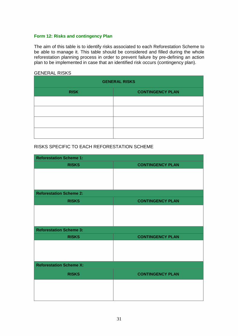
The identification of possible risks which may arise during the reforestation process (including the ones related to the implementation of the Mitigation and Reforestation Support measures) can be conducted by means of the participatory Tool 7 problems tree: cause and effect diagram (Annex 3). The identification of those risks will be done for the general reforestation process and if appropriate also for each selected Reforestation Scheme. For each risk, a contingency plan (i.e. solutions) should be provided. Tool 6 and/or Tool 8: solution tree (among other participatory tools) can be applied. Risks and contingency actions will be included in Form 12: Risks and Contingency plan. Which are the outputs?
A map of the reforestation patches, with the assignment of a well-defined Reforestation Scheme to each Block or Patch
Definition of livelihood support activities (Mitigation and Reforestation Support measures) (Form 11a and Form 11b)
Definition of R&D activities
A Memorandum of understanding (MoA) between the Municipality and: i) land users, ii) all the stakeholders interested in supporting the reforestation process, iii) Universities or Research Centers.
A Risk & Contingency plan (Form 12)

15
STAGE 4: ELABORATE REFORESTATION PLAN COMPONENTS Who participates?
The Reforestation Partners, in cooperation with the Environmental Committee (and the Universities and Research Centers if a R&D plan is proposed).
Which are the objectives?
To develop a Reforestation Plan (based on the previous stages 1, 2 and the decisions taken at Stage 3), providing details regarding the Reforestation, Livelihood support and R&D activities that will be performed (i.e. which activities, how they will be perform, when, by whom). How the Plans will be elaborated?
The outcomes of Stage 3 (i.e. selection of activities) will be turned into the Participatory Reforestation Plan describing in details the Reforestation, Livelihood support, R&D and Monitoring and Evaluation activities. These four elements form the Participatory Reforestation Plan together with the information gathered during the diagnosis process (A template of the Participatory Reforestation Plan can be found in Annex 3).The main element of the plan are the following:
1. Reforestation executive implementation Plan
This plan consists on turning the site diagnosis and the plantation Scheme selection into an executive document that will define the details on how to implement the reforestation, including its components, work plan, timeline and budget.
2. Livelihood support Plan
This plan consists on detailing the activities, both Mitigation measures and activities to support the reforestation, which have been prioritized by communities and decision makers. It will include activities that: prevent, mitigate and compensate the negative impacts of reforestation activities; prevent the risk that might threat the reforestation; valorize the utilization of forest products; promote the ownership, visibility, awareness rising of community members; and that mobilize the involvement of community members on the reforestation.
3. Research and Development Plan
A small-scale R&D fund will facilitate transfer of scientific knowledge and technology into reforestation and livelihoods support practices. Its utilization is optional. Consortium partners are encouraged to submit R&D proposals and to work in close collaboration with research institutions, universities and other appropriate institutions to provide these R&D services.
4. Monitoring and Reporting Plan
This plan will consist in actions, designed by the consortium partners to ensure that the PRP activities detailed in the Reforestation Plan, Livelihoods Support Plan and Research and Development Proposal are undertaken. The plan should consider that 6 reports should be delivered:
After planting or establishment of the reforestation site (report 1);
End of the first summer after planting (report 2);
Before the second year summer after planting (report 3);
End of the second summer after planting (report 4);
Before the third year summer after planting (report 5); and

16
Final report after the end of third year summer after planting (report 6).
The inclusion of stakeholders during the process (i.e. discussion, meetings, agreements, activities) should be documented during the whole reforestation process in order to highlight and justify that reforestation took place in a participatory manner (e.g. assistant sheets, pictures, minutes of meetings).
Which are the outputs or products that need to be delivered?
Participatory Reforestation Plan Template completed (Annex 4).

17
STAGE 5: EVALUATION AND APPROVAL OF THE PARTICIPATORY REFORESTATION PLAN Who participates?
The PRP (containing the Reforestation, Livelihoods support, R&D and Monitoring, evaluation and reporting Plan) prepared by each consortium, will be submitted to the Reforestation Unit (RU) and the Project Management Unit (PMU), copied to the DRDNR/MoA. They will evaluate and approve the proposed Plan. Which are the objectives?
To evaluate the Participatory Reforestation Plan
To propose recommendations for the improvement of the document and reforestation activities
How it will be done?
The scope, activities, outputs, outcomes, inputs and the technical and financial characteristics of the Participatory Reforestation will be evaluated by the RU and recommendations made to the PMU and the DRDNR/MoA. The PRP may be subject to technical or financial review in a negotiation between the PMU and the consortium partners. On approval of the PRP by the DRDNR/MoA, a MoU will be entered into between the PMU and the consortium partners. The PRP will serve as the basis of the MoU for planning, implementation and monitoring and evaluation of the reforestation, livelihoods support and research and development activities to be financed by the project. The approved PRP will be an Annex to the MoU. Which are the outputs or products that need to be delivered?
Memorandum of Understanding between the PMU and the consortium partners including the compromises acquired.

18
ANNEX 1: Forms of the preparatory stages
FORM 1: Work plan for PRP preparation (Stages 1-4)
ACTIVITY SUB-ACTIVITY
PERSON (ENTITY) RESPONSIBLE
Indicate further participants, if relevant
ESTIMATED COSTS
(RESOURCES NEEDED)
EXPECTED
OUTPUT
DEADLINE (at sub-
activity level) COMMENTS
19
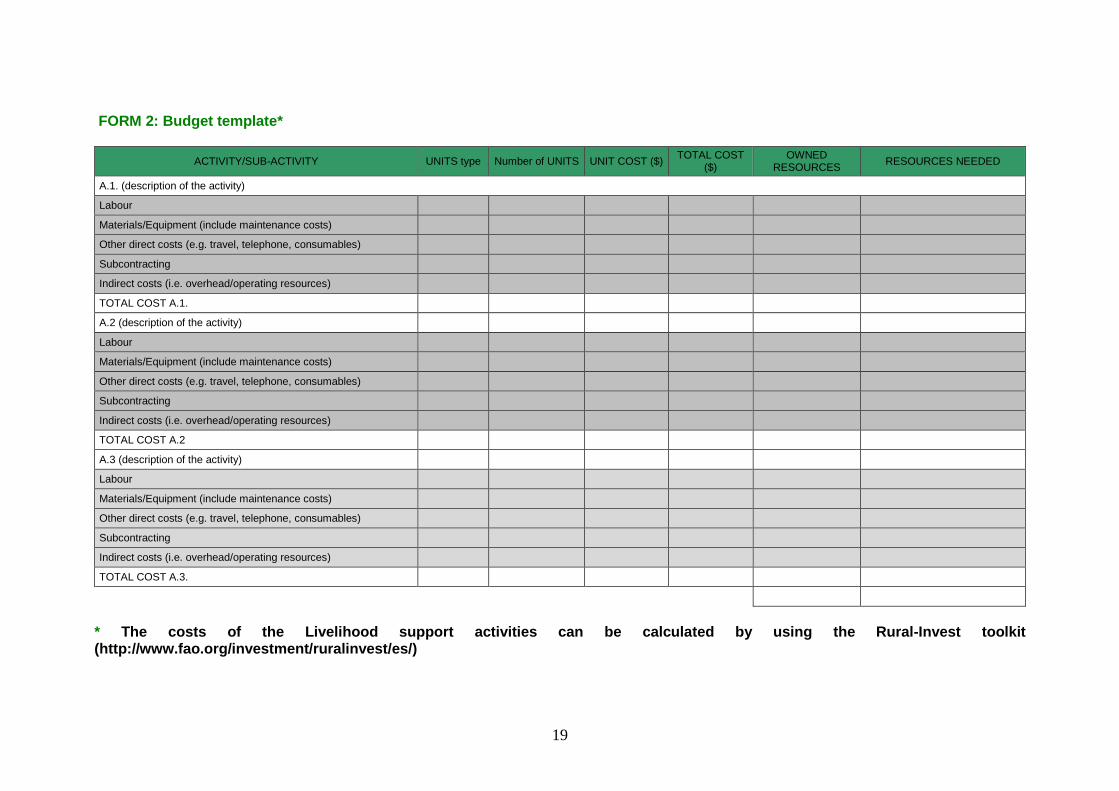
FORM 2: Budget template*
ACTIVITY/SUB-ACTIVITY UNITS type Number of UNITS UNIT COST ($) TOTAL COST
($) OWNED
RESOURCES RESOURCES NEEDED
A.1. (description of the activity)
Labour
Materials/Equipment (include maintenance costs)
Other direct costs (e.g. travel, telephone, consumables)
Subcontracting
Indirect costs (i.e. overhead/operating resources)
TOTAL COST A.1.
A.2 (description of the activity)
Labour
Materials/Equipment (include maintenance costs)
Other direct costs (e.g. travel, telephone, consumables)
Subcontracting
Indirect costs (i.e. overhead/operating resources)
TOTAL COST A.2
A.3 (description of the activity)
Labour
Materials/Equipment (include maintenance costs)
Other direct costs (e.g. travel, telephone, consumables)
Subcontracting
Indirect costs (i.e. overhead/operating resources)
TOTAL COST A.3.
* The costs of the Livelihood support activities can be calculated by using the Rural-Invest toolkit (http://www.fao.org/investment/ruralinvest/es/)

20
FORM 3: Identification of the technical support needed
THEMATIC FOR TECHNICAL SUPPORT
SUPPORT REQUIRED BY THE CONSORTIUM (fill only for those items where the consortium need support)
Responsible person to search
support and to follow up
Estimated cost
Analysis of satellite images
GPS Utilization, demarcation of reforestation Blocks
GIS Software utilization (Prepare Digitized Maps)
Identification of the soil and on-site characteristics
Participatory methodologies and tools (e.g. focus groups, SWOT analysis, stakeholders mapping)
Planning tools (e.g. budget, work-plans, timelines, logical framework)
Planning R&D Activities
Site preparation, plantation and maintenance techniques (e.g. species selection, seedling transport, seed sowing, seedling, planting, mulching, irrigation, weeding)
Livestock Protection/Improvement Measures
Monitoring & Evaluation (Survival Rate Check, reporting)
Others (specify):
Others (specify):
Others (specify):

21
FORM 4: Preliminary characterization of the zones to be reforested
The Form must be accompanied by a localization map of the potential zones to be reforested.
Cadastral Nb. *
Area (ha)
Current Use**
preferable uses***
Potential conflicts/threats
1
2
3
4
5
6
7
8
9
10
11
12
13
14
15
16
17
18
19
20
(*) N.R (not registered) (**)Abandoned land, agriculture, urbanized, rented for grazing, “opens” grazing, rock quarries, sand quarries (***) timber production, fuel-wood production, NTFP, pine nuts production, other nuts production (specify), landscape, recreation, ecotourism, control erosion, desertification protection, cultural, social, religious
22
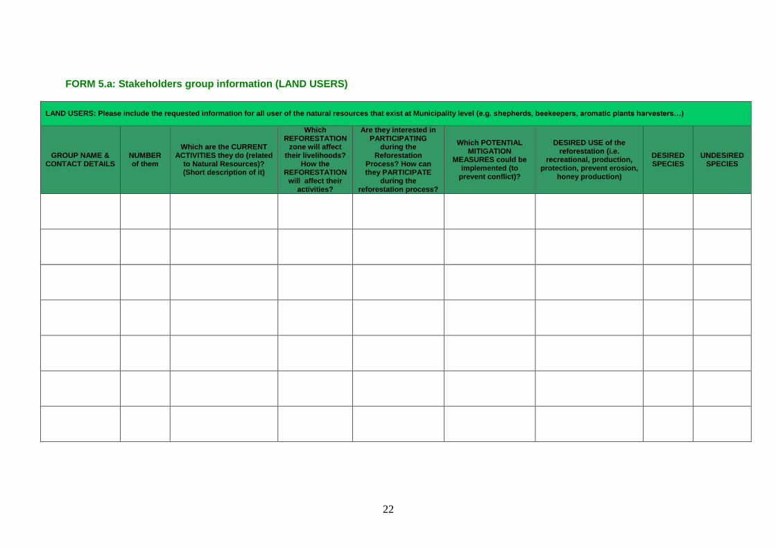
FORM 5.a: Stakeholders group information (LAND USERS)
LAND USERS: Please include the requested information for all user of the natural resources that exist at Municipality level (e.g. shepherds, beekeepers, aromatic plants harvesters…)
GROUP NAME & CONTACT DETAILS
NUMBER of them
Which are the CURRENT ACTIVITIES they do (related
to Natural Resources)? (Short description of it)
Which REFORESTATION
zone will affect their livelihoods?
How the REFORESTATION
will affect their activities?
Are they interested in PARTICIPATING
during the Reforestation
Process? How can they PARTICIPATE
during the reforestation process?
Which POTENTIAL MITIGATION
MEASURES could be implemented (to
prevent conflict)?
DESIRED USE of the reforestation (i.e.
recreational, production, protection, prevent erosion,
honey production)
DESIRED SPECIES
UNDESIRED SPECIES

23
FORM 5.b: Stakeholders group information (REFORESTATION SUPPORTERS)
REFORESTATION SUPPORTERS: Voluntary stakeholders that are interested to participate during the reforestation process (e.g. associations)
GROUP AND REPRESENTING
NAME and TLF (if appropriate)
NUMBER (of
members)
CURRENT FUNCTIONS and ACTIVITIES (related to Natural Resources) that can reinforce the
Reforestation
POTENTIAL ROLE (during the reforestation)?
DESIRED USE of the reforestation (i.e. recreational, production, protection, prevent erosion, honey production)
DESIRED SPECIES
UNDESIRED SPECIES
24
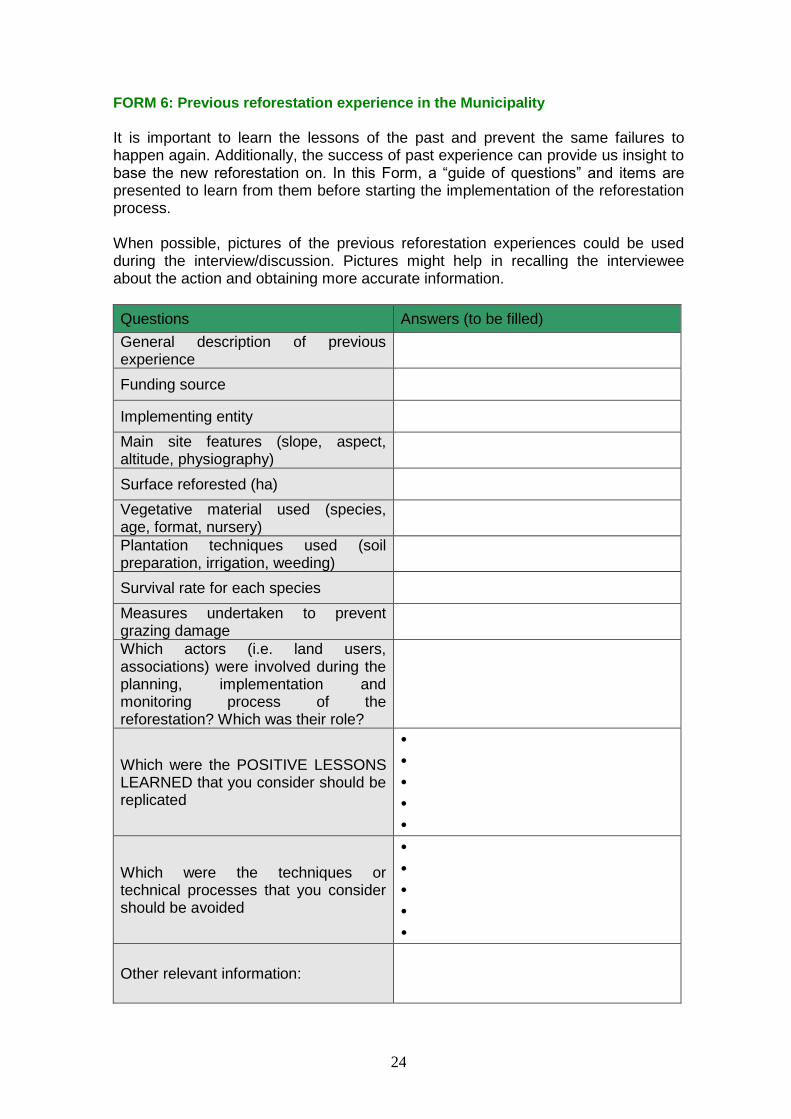
FORM 6: Previous reforestation experience in the Municipality It is important to learn the lessons of the past and prevent the same failures to happen again. Additionally, the success of past experience can provide us insight to base the new reforestation on. In this Form, a “guide of questions” and items are presented to learn from them before starting the implementation of the reforestation process. When possible, pictures of the previous reforestation experiences could be used during the interview/discussion. Pictures might help in recalling the interviewee about the action and obtaining more accurate information.
Questions Answers (to be filled)
General description of previous experience
Funding source
Implementing entity
Main site features (slope, aspect, altitude, physiography)
Surface reforested (ha)
Vegetative material used (species, age, format, nursery)
Plantation techniques used (soil preparation, irrigation, weeding)
Survival rate for each species
Measures undertaken to prevent grazing damage
Which actors (i.e. land users, associations) were involved during the planning, implementation and monitoring process of the reforestation? Which was their role?
Which were the POSITIVE LESSONS LEARNED that you consider should be replicated
• • • • •
Which were the techniques or technical processes that you consider should be avoided
• • • • •
Other relevant information:

25
FORM 7: Characterization of livestock activitiy
This table presents a selection of topics and questions, as a guideline for the rangeland mapping discussion, which might provide elements to take decisions concerning the areas to be reforested. The objective of this characterization is to identify potential constrains to the initially proposed reforestation areas due to the grazing activities and initial identification of potential activities to mitigate those constrains.
Livestock activity Local External*
Please indicate number of herds and total estimated number of animals
Type of Herds Permanent Seasonal Permanent Seasonal
Goats
Sheep
If seasonal, which is the length of the season (specify which months)?
Do they have any type of arrangement/agreement with the municipality (e.g. contract)? If yes, specify the agreement characteristics.
Which are the resources they use and where are they located on the cadastral map? (e.g. fodder, water, shelter). Specify the seasonal changes, if any.
Are there any other locations/areas/resources at municipality level or beyond that can beused alternatively (providing similar services)?
Which are the tracks they use (daily pattern)? (mark them on the map)
Are there any other alternative paths they can use?
Could you explain the potential impact that the reforestation will have on your livestock activity? (try to quantify it)
Is there any manner in which this impact could be reduced?
*For the shepherd workshop, shepherds from both the region and outside will be invited to the workshop. If the shepherds are not the owners of the cattle, cattle owners should also participate in the discussion workshop. When not possible to assemble shepherds from outside the community, key stakeholders which knowledge on their grazing patterns will be assemble instead.

26
FORM 8: Summary of Physical data at Municipal level
Name of the Municipality
BIOCLIMATIC INFORMATION
¿Which are the Bioclimatic step/s and series of vegetation present in your municipality?
Bioclimates: Mediterranean: thermomediterranean; Eumediterranean; Supramediterranean; Montane-Mediterranean; Oromediterranean; Presteppic: Mediterranean Presteppic; Presteppic supramediterranean; Presteppic montane Mediterranean; Presteppic oromediterranean
Vegetation series CLIMATE INFORMATION
Annual average rainfall (mm) Monthly rainfall (mm)
1 2 3 4 5 6 7 8 9 10 11 12
During which months does the snow cover the ground normally?
Is there any other particular climate event (e.g. strong prevailing wind, moving fogs)? If so, describe
SOIL
pH
Texture
Are active limestone, gypsum or salinity a problem?
FLORA
Tree and shrub species (see list below*) currently present in the area to reforest
Tree and shrub species (see list below*) in surrounding areas (including neighboring municipalities) with similar features
Tree and shrub species (see list below*) previously present in the area and surrounding areas with similar features (historical records)1
OTHERS Water collection and/or storage facilities (mapped)
*Species list: Abies cilicica; Acer monspessulanum; Acer syriacum; Acer tauricolum; Adenocarpus complicatus; Alnus orientalis; Amygdalus communis; Amygdalus korschinskii; Arbutus andrachne; Arceuthos drupacea; Berberis libanotica; Castanea sativa; Cedrus libani; Celtis australis; Ceratonia siliqua; Cerasus microcarpa; Cercis siliquastrum; Coryllus avellana; Crataegus spp; Cupressus sempervirens; Ficus carica; Ficus opuntia; Fraxinus ornus; Fraxinus syriaca; Juglans regia; Juniperus drupacea; Juniperus excelsa; Juniperus foetidissima; Juniperus oxycedrus; Laurus nobilis; Malus trilobata; Myrtus communis; Olea europaea; Onionis spp; Ostrya carpinifolia; Phillyrea spp; Phlomis spp.; Pinus brutia; Pinus halepensis; Pinus nigra; Pinus pinea; Pistacia lentiscus; Pistacia palaestina; Platanus orientalis; Populus alba; Populus nigra; Prunus amygdalis; Prunus ursina; Pyrus syriaca; Quercus brantii; Quercus calliprinos;Quercus cerris; Quercus infectoria; Rhamnus spp; Rhus coriaria; Rosa canina; Rubus spp.; Salix alba; Salix libani; Sorbus torminalis; Sorbus umbellatus; Spartium junceum; Styrax officinalis; Other species 1If the environmental committee is not aware of it, this identification can be done through interviews with key actors of the Municipality (e.g. elderly, middle-aged, former leaders, historians, representative members of the community) or, in case the information is contradictory, by using focus groups with those key actors. This information can be supplement by historical literature which might allows tracking the previous species used in the community.

27
FORM 9: Summary of Physical data at Reforestation Patch level
Name of the Municipality
Reforestation Compartment
Reforestation Patch2
GPS track / code
PHYSIOGRAPHIC INFORMATION (GIS, confirmed with on-field work)
Average altitude
Position at the slope (Figure adapted from Gonin et al, 2013)
Prevailing Aspect/s N / NW / W / SW / S / SE / E / NE / flat
Steepness range (%) 0-10 / 10-30 / 30-60 / +60
SOIL (field work)
Depth (cm) <30 / 30-50 / 50-80 / >80
Stoniness (sized 0,2-20 cm Ø) (%) 0-15 / 15-40 / >40
Rockiness (%) 0 / 1-15 / 15-40 / >40
FLORA (field work + consultation)
Current land-use
Previous land-use
Present species
Previous species
OTHERS (during field work + GIS + consultation)
Traces / evidences of livestock Severe / Present / Absent
Accessibility to the perimeter of the patch All vehicles / 4x4 & caterpillars / inaccessible
Accessibility within the Patch All vehicles / 4x4 & caterpillars / inaccessible
Signs of erosion No / slight / moderate / severe
Key remarks (signs of flooding, average height or density of shrubs, vulnerable / indicative species, type of landscape – grassland, shrubland)
2 Attached a map with the location of each patch

28
Form 10: Reforestation Schemes drafting
This Form, ideally consisting on 2 to 6 Reforestation Schemes, will be prepared for each Reforestation Block.
Reforestation Block (X) Scheme X.1
Scheme X.2
Scheme X.3
Scheme X.n
Reforestation aim (production, protection, landscape, cultural…)
Species
Suitable densities (number of trees/ha )
Soil preparation (manual or mechanized pit digging, , sub-soiling, micro-terracing)
Irrigation (drippers + deposits, tanker + hose, no)
Tree Protection description (no protection, individual shelters, fencing)
Plantation techniques (e.g. Mulching, soil conditioners)
Maintenance during first 5 years (weeding, pruning, grafting at year X)
Foreseen management during first 25 years (rough description of management activities)
Estimation of implementation costs during first year ($/ha)
Estimation of implementation costs during years 2-5 ($/ha)
Additional modifications of Schemes: in order not to create many Schemes with small differences between them, it is possible to add (quantified economically) some modifications common for all Schemes (e.g. how much it would imply to add a perimeter fence instead of individual shelters)

29
FORM 11a: Identification of potential livelihood support actions (MITIGATION MEASURES)
The aim of this Form is to propose actions that that will help to ensure the success of the reforestation actions by minimizing the threats to reforestation activities and generating alternatives to the land users of the areas that have been selected for reforestation (e.g. shepherds improvement measures, non timber forest products users). The list of activities should include the following items:
Description of the activity* Target
beneficiaries Stakeholders
involved
Describe the impact the activity will have on the
beneficiaries
Describe the impact the activity will have on the reforestation (if
any)**
Estimated budget***
Ranking (by preferences)
* Improve livestock pasture; improve livestock access to water, improve the dairy product processing and storage; improve the access to financial services ** Examples are control for animal grazing, increase the survival rate of the reforestation *** To calculate the cost of each livelihood support activity and take final decision on which implement, Rural-Invest toolkit (http://www.fao.org/investment/ruralinvest/es/) or the budget template of Form 2 could be used.

30
FORM 11b: Identification of potential livelihood support actions (ACTIVITIES TO SUPPORT REFORESTATION)
The aim of this Form is to propose activities that can be performed by stakeholders that are willing, voluntarily, to support the reforestation process. Those activities might help to prevent the risks and threats related to the future reforestation that were identified on the previous section. Therefore, they should be ideally oriented towards the support of the contingency plan. The list should include the following items:
Description of the activity Stakeholders
involved Describe the impact the activity will
have on the reforestation** Describe the need of support *** Ranking (by preferences)
** Examples of potential impacts are control for illegal harvest, uncontrolled fires prevent pest and diseases, monitor the survival of the trees, increase the visibility of the reforestation. *** In case there is a need of economic support, Rural-Invest toolkit (http://www.fao.org/investment/ruralinvest/es/) or the budget template of Form 2 could be used.
31
Form 12: Risks and contingency Plan
The aim of this table is to identify risks associated to each Reforestation Scheme to be able to manage it. This table should be considered and filled during the whole reforestation planning process in order to prevent failure by pre-defining an action plan to be implemented in case that an identified risk occurs (contingency plan). GENERAL RISKS
GENERAL RISKS
RISK CONTINGENCY PLAN
RISKS SPECIFIC TO EACH REFORESTATION SCHEME
Reforestation Scheme 1:
RISKS CONTINGENCY PLAN
Reforestation Scheme 2:
RISKS CONTINGENCY PLAN
Reforestation Scheme 3:
RISKS CONTINGENCY PLAN
Reforestation Scheme X:
RISKS CONTINGENCY PLAN

32
ANNEX 2: Example of the methodology
Example of the Methodology to characterize the reforestation sites The Municipality X has 3 areas to reforest (3 compartments). Stage 1: pre-assignation of preferential zones / biotic/abiotic factors that may influence the reforestation (communicated by the Municipality to the NGO) E.g: Compartment 1 shows a steep slope and some ongoing erosion processes Compartment 2 is an irregular area with various slopes and aspects, and there is a water reservoir at the western part and interest to make an income generation land-use here Compartment 3 is a slope with constant steepness and aspect Stage 2: Site diagnosis Diagnosis at Municipality level (common to all 3 Compartment - done at the
office) Diagnosis at Patch level (office + on-field): identifying homogeneous
Patches within each compartment (physiography, steepness, soil features (depth, stoniness, rockiness), current land use, accessibility, ongoing erosion)
After walking in the area and doing some soil samples the field team identifies homogeneous Patches within each compartment:
Patch 1.1
Patch 1.2
Patch 2.2 Patch 2.1
Patch 2.3
Patch 3.1
COMPARTMENT 1
COMPARTMENT 2
COMPARTMENT
3

33
- Patch 1.1: area of Compartment 1 with mild slope (20-40%), heading NE to NW, without erosion problems and with some scattered vegetation - Patch 1.2: area of Compartment 1 with steep slope (>40%) heading NE to N, with ongoing erosion problems) - Patch 2.1: flat area besides the water reservoir, easy to mechanize and to irrigate - Patch 2.2: area with gentle slope (10-30%), heading N - Patch 2.3: area with steep slope (40-60%), heading E to NE, with incipient erosion problems - Patch 3.1: area with gentle slope (20-40%), heading E to NW All Patches with similar features are assigned to Reforestation Blocks: Patch 1.1, Patch 2.2 and Patch 3.1 are similar Reforestation Block A Patch 1.2 & Patch 2.3 are similar Reforestation Block B Patch 2.1 Reforestation Block C Each reforestation block receives a Priority category: block B is urgent and necessary to be reforested (Priority 1); blocks A & C are non-urgent and necessary to be reforested (Priority 2). There are no blocks under other priorities. Putting together Municipality Diagnosis and Site Diagnosis: Assignation of
suitable Reforestation Schemes for each Reforestation Block (2 to 6 reforestation Schemes, with some further open options):
Block A: reforestation Schemes, with rough economic estimation per hectare:
Reforestation Scheme A1
Reforestation Scheme A2
Reforestation Scheme A3
Reforestation Scheme A4
Reforestation aim
Production Production Production + protection / landscape
Protection / landscape
Species Pinus pinea
Pinus pinea grafted on Pinus brutia
Pinus pinea, Juniperus excelsa, Pyrus syriaca
Juniperus excelsa, Pyrus syriaca, Malus trilobata, Acer tauricolum
Suitable densities
600 trees/ha, pure plantation
400 trees/ha, pure plantation
600-800 trees/ha, mixed plantation
800-1000 trees/ha, mixed plantation
Soil preparation
Manual Manual Manual Manual
Irrigation No No No No Protection Individual
shelters Individual shelters
Individual shelters
Individual shelters
Plantation techniques
Mulching, soil conditioners
Mulching, soil conditioners, grafting at year 3
Mulching -
Estimation of costs during 1st year, ~$/ha
800 - 1000 600 - 700 700 - 900 800-1000

34
Estimation of costs during years 2-5, $/ha
200 - 300 800 - 1000 200 - 300 300 - 400
Further options for block A:
- mechanical soil preparation instead of manual: +$500 - fencing instead of individual shelters: +$2000
Block B: Reforestation Schemes, with rough economic estimation per hectare:
Reforestation Scheme B1
Reforestation Scheme B2
Reforestation aim Protection / landscape
Protection / landscape
Species Juniperus excelsa Juniperus excelsa Legumes seeding
Suitable densities 1000 trees/ha 1000 trees/ha Soil preparation Manual Manual Irrigation No No Protection No No Plantation techniques
Soil conditioners No
Estimation of costs during 1st year, ~$/ha
800 - 1000 1100 - 1300
Estimation of costs during years 2-5, $/ha
200 - 300 300 - 400
Further options for block 2:
- installing tree shelters: +$1000/ha
Block 3: Reforestation Schemes, with rough economic estimation per hectare:
Reforestation Scheme 1
Reforestation Scheme 2
Reforestation Scheme 3
Reforestation Scheme 4
Reforestation aim Production of pine nut
Production of pine nut
Production of fruit
Landscaping / Orchard for local population
Species Pinus pinea Pinus pinea grafted on Pinus brutia on year 3
Various fruit trees: walnut, almond, pear, apple
Various fruit trees: walnut, almond, pear, apple, aromatic & medicinal plants
Suitable densities 600 trees/ha 400 trees/ha 600 trees/ha 800 trees/ha Soil preparation Crossed sub-
soiling Crossed sub-soiling
Crossed sub-soiling
Crossed sub-soiling
Irrigation Drippers Drippers Drippers Manual Protection Fencing Fencing Fencing Fencing

35
Plantation techniques
Mulching Mulching Mulching No
Estimation of costs during 1st year, ~$/ha
2000 - 3000 2000 - 2500 3500-4000 2000-2500
Estimation of costs during years 2-5, $/ha
200 - 300 800 - 1000 300-400 1000-1500
Further options for block 3: no fencing: -$1500 Stage 3: Participatory mapping Participatory selection and assignation of a unique reforestation Scheme to each reforestation block (and to each Patch if necessary)

36
ANNEX 3: Community Appraisal Tools
Tool 1: WORK-PLAN, TIMELINE & BUDGET
Description and objectives
The work plan is a planning document that includes the actions, goals, persons in charge, and timelines needed to execute the action. Additionally, a budget estimates the cost of each activity. The idea is to mobilize the people’s ability to design a plan of action. The participatory action plan should be drawn up on the basis of criteria that are easy to understand; the matrix is a graphic representation of the plan and must be clear to everyone, since it will be used as the basis for follow-up and evaluation.
Methodology
The participants have a list of objectives, activities, sub-activities (if they need to be subdivided), and goals (outputs of each activity or sub-activity). Everyone involved should take part in drawing up the matrix.
Step 1: Present and reach consensus on a methodology Agree on the matrix format and on symbols to be used for activities and sub-activities, as well as the time frames to be used (they should be convenient for the people). A propose work-plan matrix can be found in Annex 1-Form 1a, proposed timeline in Annex 1-Form 1b and proposed budget in Annex 1-Form 2.
Step 2: Identify specific tasks that need to be done Define and review the activities and sub-activities needed to reach the established goals. The work-plan matrix has to identify the different activities and sub-activities necessary to reach the goals proposed.
Step 3: Decide on responsibilities. Who will do what? Indicate who will be responsible for each sub-activity.
Step 4: Timeline Indicate how much time is foreseen for carrying out each activity (the best way is to make a graph showing when the activity starts and when the goal must be completed). The graphic timeline makes it possible to determine if all the activities planned can actually be done; for each period, make sure that the plan does not include too many activities. It is good to establish a deadline for each activity.
Step 5: Estimate Costs for Each Task (activity or sub-activity). There are essentially four major types of costs associated with any activity: Labour; Materials; Other direct costs (travel, telephone etc.); Indirect costs (i.e. overheads – office rental, utilities, administrative costs). For most tasks in environmental projects, the largest expense will be labour (e.g. staff, consultants or partners) which is why it is important to identify who is responsible and estimate how long each activity will take before estimating the financial cost.
Step 6 Review the work-plan and budget. Both documents are essential for the success implementation of the plan. It will guide project implementation and monitoring. The matrix proposed should be reviewed and discussed by all actors involved before it is approved.
Resources required for leading a focus group
Abilities of the staff responsible for the activity - A comprehensive facilitator, able to synthesize and moderate the work plan drawing. Material required - Blackboard, markers. Time required - Depends on the complexity of the plan but should not take longer that 2-3 hours

37
Tool 2: Stakeholders mapping
Description and aims of stakeholder mapping
Stakeholder mapping helps to identify the stakeholders affected by the reforestation (either users of the land or actors that have an interest in participate actively in the reforestation process). It helps on identifying their interests, abilities and potential role during the reforestation process (planning, implementation, monitoring and evaluation). Stakeholder mapping begins at the start of the diagnosis phase, as it helps identify sources of information and resource people, and it is continued and supplemented throughout the process, given
that new data is integrated and that new stakeholders may join the initiative.
Methodology to produce the stakeholder map
Step 1. Specify the objectives for stakeholder participation
Clarify the objectives and the reasons for stakeholder involvement - Why is it desirable to involve stakeholders in the process? - What is expected from this participation?
- What is the added value of this participation? Step 2. Identify key stakeholders affected for the reforestation (land user)
- Perform brainstorming sessions through focus groups (Tool 4, Annex 2), or individual interviews (Tool 3, Annex 2), with associations, public and private institutions, research centers and universities involved in the sector.
- Build up a Venn diagram of stakeholders by initially identifying the major groups concerned by the reforestation towards the centre of the diagram, then detailing these groups toward the periphery of the image. Where necessary, use color codes and annotations, symbols, etc.
Source: IICA, 2008.
- Fill the Form 5a: Stakeholders group information (LAND USERS) - Take time to assess the initial lists of stakeholders and decide if there are less well
known or less obvious stakeholders still to be identified. - Supplement the initial list from secondary sources (such as historical documents or
local newspapers, etc.), government statistics and data, lists of organizations, etc.

38
Step 3. Identify reforestation supporters (stakeholder interest in the reforestation)
As well as for land users, stakeholders interested to actively participate on the reforestation can be identified via a focus group and meetings or interviews. Stakeholders are classed according to their interest in the proposed objective or activity and the impact its participation will have on the reforestation. The Form 5b: Stakeholders group information (REFORESTATION SUPPORTERS) can be used as a guide.
Step 4. Assess the influence and significance of those stakeholders participating in the activities (optional)
Assessing the importance of the participation of different stakeholders might be needed in case there are a large number of stakeholders in the territory. The following matrix can be used to prioritize the participation of stakeholders.
Criteria stakeholde
r 1 stakeholde
r 2 stakeholde
r 3 …
Influence. What is the influence of stakeholder X in the reforestation?
Significance. What is the significance (importance) of stakeholder X’s participation in the reforestation?
…(other criteria)
This information will provide tools to prioritize the participation and define a participation strategy. Individual meetings and negotiations with stakeholders will be also helpful during this process.
Resources required to perform stakeholder mapping
Abilities of the staff responsible for the activity - Excellent facilitation skills are required. Equipment required - Flipchart, post-it notes, pencils and, for group discussions, a suitable comfortable
meeting room, along with participant incentives (such as refreshments). Time required - Once the stakeholders have been identified, each step may take an hour or two. A
complete analysis may take a whole day or more
Sources of useful information for stakeholder mapping Forestry Commission, 2011. Public engagement in forestry: A toolbox for public engagement in forest and woodland planninghttp://www.forestry.gov.uk/ FAO, 2013. Website. Stakeholder analysis http://www.fao.org/Participation/english_web_new/content_en/stakehold.html
39
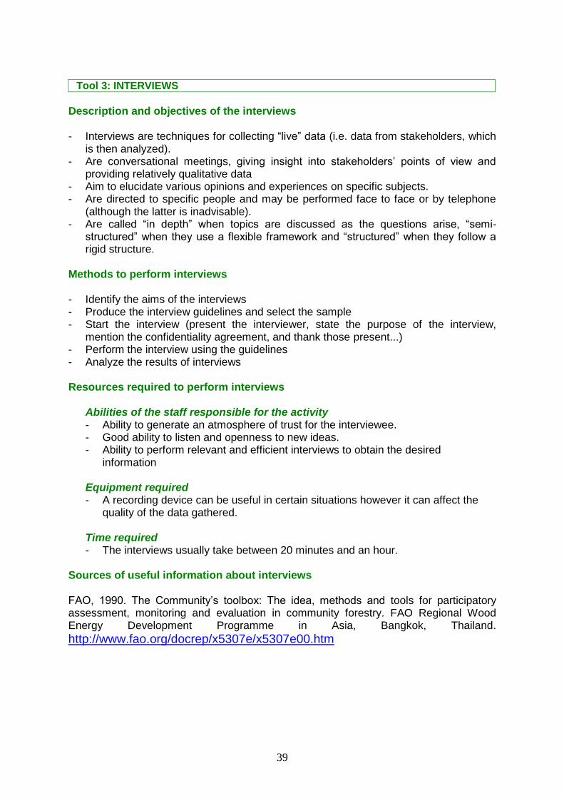
Tool 3: INTERVIEWS
Description and objectives of the interviews - Interviews are techniques for collecting “live” data (i.e. data from stakeholders, which
is then analyzed). - Are conversational meetings, giving insight into stakeholders’ points of view and
providing relatively qualitative data - Aim to elucidate various opinions and experiences on specific subjects. - Are directed to specific people and may be performed face to face or by telephone
(although the latter is inadvisable). - Are called “in depth” when topics are discussed as the questions arise, “semi-
structured” when they use a flexible framework and “structured” when they follow a rigid structure.
Methods to perform interviews - Identify the aims of the interviews - Produce the interview guidelines and select the sample - Start the interview (present the interviewer, state the purpose of the interview,
mention the confidentiality agreement, and thank those present...) - Perform the interview using the guidelines - Analyze the results of interviews Resources required to perform interviews
Abilities of the staff responsible for the activity - Ability to generate an atmosphere of trust for the interviewee. - Good ability to listen and openness to new ideas. - Ability to perform relevant and efficient interviews to obtain the desired
information Equipment required - A recording device can be useful in certain situations however it can affect the
quality of the data gathered. Time required - The interviews usually take between 20 minutes and an hour.
Sources of useful information about interviews FAO, 1990. The Community’s toolbox: The idea, methods and tools for participatory assessment, monitoring and evaluation in community forestry. FAO Regional Wood Energy Development Programme in Asia, Bangkok, Thailand.
http://www.fao.org/docrep/x5307e/x5307e00.htm

40
Tool 4: DISCUSSION TECHNIQUES (FOCUS GROUPS & WORKSHOPS)
Description and objectives of focus groups & workshops This is a technique where participants discuss specific questions and topics in depth, with the help of a qualified facilitator. Focus groups often comprise 5- 15 people, who represent various points of view and stakeholder interests. The tool can be applied with groups of experts who have knowledge of the topic under consideration or with representatives of a specific sector of society.
Methodology to organize a focus group
Prior to the discussion During the discussion
Decide the purpose of the discussion
Decide who should be invited due to their knowledge of the topic
Specify the characteristics of the meeting (date, duration, number of groups, etc.)
Produce the invitations
Choose a technique to use (games and graphic tools improve the results of the discussions)
Thank the participants for coming and participating
Explain the purpose of the focus group and the aims of the meeting
Explain how the meeting will take place and how members can contribute
Specify the rules of debate
Encourage open participation
Set the tone by asking an opening question and ensuring that all opinions on this question are heard
Ask other questions generally
When all questions have been asked, ask if anyone has further comments
Explain to the group the next steps which will occur
Thank the group for coming and actively participating
Resources required for leading a focus group
Abilities of the staff responsible for the activity - A coordinator able to stimulate and moderate the debate and ensure compliance with
speaking times, which is preferably independent and neutral with respect to the topic. - Someone to take notes on the significant questions and answers, and on factors that
could help in understanding the information. Equipment required - Facilities that enable convenient, welcoming meetings. - Incentives for participants, such as a breakfast. - Audio recording devices. Time required - The discussions should take an hour or two.
Sources of useful information about focus groups Elliott J, Heesterbeek S, Lukensmeyer CJ and Slocum N. 2005 Participatory Methods Toolkit. A practitioner’s manual. Slocum Nikki, Participatory Methods Toolkit: A Practioner's Manual, 2nd edition, in collaboration with ViWTA and King Baudoin Foundation, Brussels, 210 p. (available in English and French).http://www.cris.unu.edu/sbook.175.0.html?cHash=4fd03ade56&tx_ttnews[tt_news]=467

41
The Community Toolbox. 2013. Chapter 3. Assessing Community Needs and Resources. Section 6. Conducting focus groups. http://ctb.ku.edu/en/tablecontents/sub_section_main_1018.aspx
42
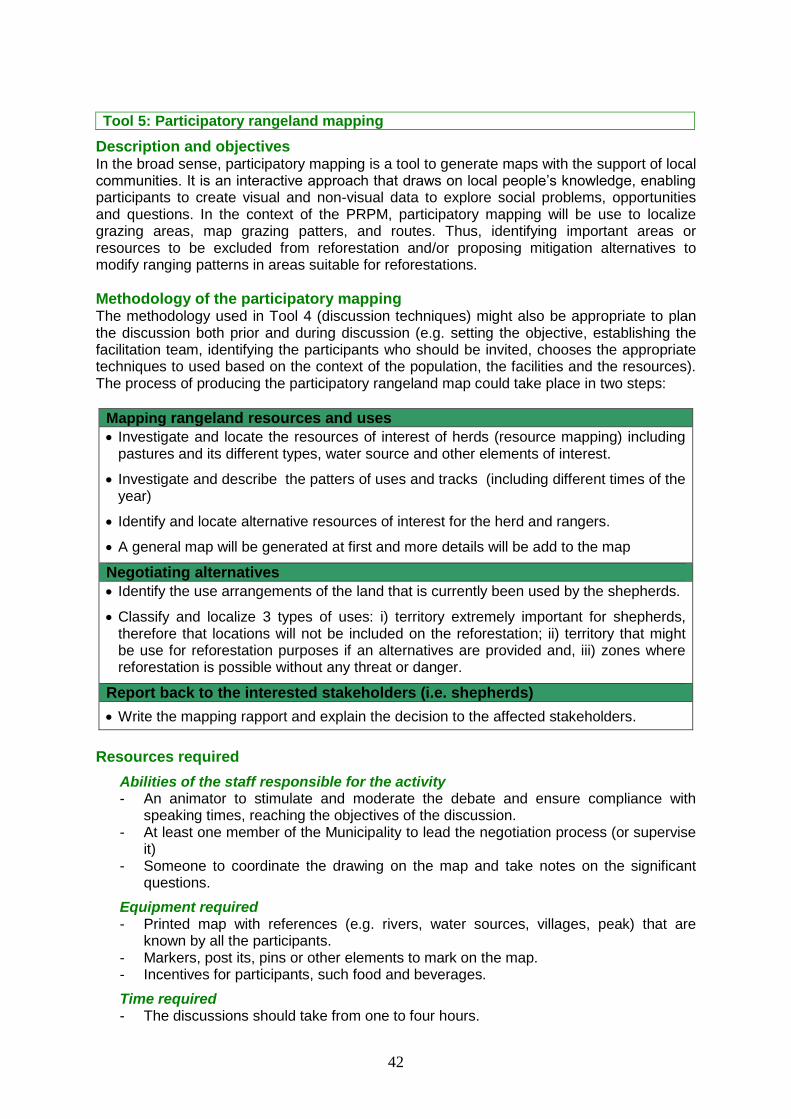
Tool 5: Participatory rangeland mapping
Description and objectives In the broad sense, participatory mapping is a tool to generate maps with the support of local communities. It is an interactive approach that draws on local people’s knowledge, enabling participants to create visual and non-visual data to explore social problems, opportunities and questions. In the context of the PRPM, participatory mapping will be use to localize grazing areas, map grazing patters, and routes. Thus, identifying important areas or resources to be excluded from reforestation and/or proposing mitigation alternatives to modify ranging patterns in areas suitable for reforestations.
Methodology of the participatory mapping The methodology used in Tool 4 (discussion techniques) might also be appropriate to plan the discussion both prior and during discussion (e.g. setting the objective, establishing the facilitation team, identifying the participants who should be invited, chooses the appropriate techniques to used based on the context of the population, the facilities and the resources). The process of producing the participatory rangeland map could take place in two steps:
Mapping rangeland resources and uses
Investigate and locate the resources of interest of herds (resource mapping) including pastures and its different types, water source and other elements of interest.
Investigate and describe the patters of uses and tracks (including different times of the year)
Identify and locate alternative resources of interest for the herd and rangers.
A general map will be generated at first and more details will be add to the map
Negotiating alternatives
Identify the use arrangements of the land that is currently been used by the shepherds.
Classify and localize 3 types of uses: i) territory extremely important for shepherds, therefore that locations will not be included on the reforestation; ii) territory that might be use for reforestation purposes if an alternatives are provided and, iii) zones where reforestation is possible without any threat or danger.
Report back to the interested stakeholders (i.e. shepherds)
Write the mapping rapport and explain the decision to the affected stakeholders.
Resources required
Abilities of the staff responsible for the activity - An animator to stimulate and moderate the debate and ensure compliance with
speaking times, reaching the objectives of the discussion. - At least one member of the Municipality to lead the negotiation process (or supervise
it) - Someone to coordinate the drawing on the map and take notes on the significant
questions.
Equipment required - Printed map with references (e.g. rivers, water sources, villages, peak) that are
known by all the participants. - Markers, post its, pins or other elements to mark on the map. - Incentives for participants, such food and beverages.
Time required - The discussions should take from one to four hours.

43
Sources of useful information about focus groups IFAD. 2009. Good practices in participatory mapping, A review prepared for the IFAD. http://www.ifad.org/pub/map/pm_web.pdf
Tool 6: Preferences ranking
Description and aims
The objective is to take decision or stated preferences in a systematic manner by comparing different options (e.g. activities, Reforestation Schemes) based on a series of criteria.
Methodology
Step 1. Determine and reach consensus on evaluation criteria
Depending on the nature of the alternative, the criteria might include the following: • Benefits for the municipality (e.g. productivity/income-generating capacity) • Sustainability of the alternative (can we do it with little external aid and continue doing it after the aid is withdrawn?) • Technical and social feasibility (can it be done, and is it acceptable?) • Waiting time: When will we start to see the benefits? • Cost
Step 2. Prepare a ranking matrix
With the rows headed by the different solutions (or alternatives) to be evaluated and the columns headed by the evaluation criteria. Additionally, participants should agree on the scoring method (eg. 1-5)
Source: IICA, 2008.
Step 3. For each alternative, review the different criteria and write down a score for each one.
The facilitator should avoid a common mistake: confusing positive and negative scores, e.g., using 3 for “highly beneficial” and 3 for “long wait” or “cost too high”. To avoid this mistake, it is a good idea to express all the criteria in positive terms (e.g., speed of impact, need for financing). Once the matrix has been completed, the scores can be added or combined to prioritize the different alternative
Resources required
Abilities of the staff responsible for the activity

44
An experienced facilitator who should take a proactive role in all steps.
Equipment required Paper, cards, markers, blackboard
Time required Maximum 3 hours, depending on the complexity of the issue and the number of participants.

45
Tool 7: Problems tree: cause and effect diagram
Description and aims A problem or threats tree provides an overview of all the problems that can rise during the reforestation. It also helps to identify the known causes and effect to an identified problem. Understanding the context helps reveal its complexity and this is essential in planning successful actions. A problem tree involves writing causes in a negative form (e. g. lack of knowledge, not enough money etc). Reversing the problem tree, by replacing negative statements with positive ones, creates a solution tree. A solution tree identifies means-end relationships as opposed to cause-effects. This provides an overview of the range of projects or interventions that need to occur to solve the core problem.
Methodology Step 1. Review the problems identified and list each one on a separate card/post it
Brainstorming with all participants identifying the problems that can affect the reforestation process. Each participant should write one problem per card/post it.
Step 2. Identify a major problem and related causes and effects
Ask them to identify a problem they consider very important. Place the card/post-it in the middle of the blackboard or paper. Identify the causes and effects of that problem from the other problems- cards. Brainstorm to see if they can identify other causes It is convenient to provide participants with an example.
Step 3. Identify the other central problems
Repeat the exercise to identify other problems that might be a “consequence” of problems already placed on the board.
Step 4: Review not used cards
Review all the cards that have not been put up, to see if there might not be a relationship between them and some of the cards already placed on the board.
Step 5. Verify the problem-tree
At the end, there should be one or more problem “trees”. It is very important to be able to
determine if there is a “central” problem on the tree or trees that leads to most of the other problems. Ask the participants what they think of the exercise. Write down the result and give the paper or a copy of the results to the group
Resources required Abilities of the staff responsible for the activity - A facilitator with excellent coordination skills, able to stimulate and moderate the
different stages and ensure compliance with times Equipment required - Cards or post-it, blackboard to stick the post-its or the cards, markers. Time required - 1-3 hours, depending on the complexity of the issue and the number of participants

46
Tool 8: Solutions tree
Description and aims A solution (or objectives) tree is developed by reversing the negative statements that form the problem tree (previous tool) into positive ones. For example, a cause (problem tree) such as “lack of knowledge” would become a means such as “increased knowledge”. In this document, the solution tree might be use to identify a contingency plan (i.e. solutions) for each of the problems, risk and threats that might hamper the reforestation success.
Methodology The solution tree is based on the problem tree. Additionally to it, to identify the feasibility and select the adequate solution a Solution Matrix might be used. The methodology to develop the Solution matrix and select the best solution might be the following:
Step 1. Reach consensus on evaluation criteria
The criteria might be defined by the group elements that might be included are: Cost, technical feasibility, social acceptability among others
Step 2. Prepare a Matrix
Generate a Matrix where the criteria are represented by columns and the different solutions in rows as the table below:
SOLUTION COST
(score)
TECHNICAL FEASIBILITY
(score)
SOCIAL ACCEPTABILITY
(score)
TOTAL SCORES
Solution 1 3 1 2 6
Solution 2 2 3 3 8
Solution 3 1 2 1 4
Score each solution by using Tool 6 or other method considered appropriate.
Step 3. Final prioritization
Explain and synthesize the solutions that have been prioritized. It might be adequate to identify the next steps of the process that will follow.
Resources required
Abilities of the staff responsible for the activity - A facilitator with excellent coordination skills, able to stimulate and moderate the
different stages and ensure compliance with times
Equipment required - Cards or post-it, blackboard to stick the post-its or the cards, markers.
Time required - 1-3 hours, depending on the complexity of the issue and the number of participants

47
ANNEX 4: Participatory Reforestation Plan Template
This Annex proposes the different sections that might be include in a Participatory Reforestation Plan. The stakeholders that should be involved in each section are indicated in green using the following code (M: Municipality, RP: Reforestation Partners, RC: Reforestation Consortia, LU: Land Users; RF: Reforestation supporters). A description of the information that should be included in each section is described after each title section. The document also specifies in which stage the information is gathered. Additionally, it specifies, by using the acronym CN, which information has already been gathered by means of the concept note (either partial or complete).
1. BACKGROUND AND JUSTIFICATION (RC)
Include the scope, rationale of the reforestation and the livelihood support actions (e.g. Why the Municipality wants to perform reforestation activities? What issues will be solved by it? What will be the general benefits of the reforestation? How livelihood support activities will increase the success of reforestation activities? This information can be gathered from the Concept Note (Maximum 1 page).
2. OBJECTIVES OF THE REFORESTATION (RC)
Include the overall long term goal of the reforestation and the specific goals that the Municipality wants to achieve by it and the livelihood support actions (e.g. generate employment, production of goods and services, income opportunities). This information can be gathered from the Concept Note (Maximum 1 page).
3. PREVIOUS REFORESTATION EXPERIENCES (RC)
Include a short description of the previous reforestation experiences that have taken place in the Municipality as indicated in Form 6 at the Stage 2 (Maximum 1 page).
4. SITE & STAKEHOLDERS DESCRIPTION (RC)
Include the information that has been gathered during the Stage 2: Site and Socioeconomic Diagnosis organized as follows.
4.1. MUNICIPALITY PHYSICAL DESCRIPTION (RC)
Include the information of Form 8: Summary of physical data at Municipality level organized as follows.
4.1.1. CLIMATE SUMMARY
4.1.2. SOIL
4.1.3. FLORA & PHYSIOGRAPHIC INFORMATION
4.1.4. HYDROLOGY, EROSION PROBLEMS AND OTHER ISSUES

48
4.2. REFORESTATION COMPARTMENT IDENTIFIED (RC, LU, RS)
Include the information that has been gathered during the fist part of the Stage 2: Site and Socioeconomic Diagnosis.
4.2.1. MAP OF LIVESTOCK ACTIVITIES (RC, LU)
Include the information of Form 7: Livestock activities characterization and the map resulted of the participatory rangeland mapping process.
4.2.2. MAP OF OTHER MAJOR CONSTRAINTS (RC, LU)
In case that there are other major elements conditioning the reforestation process (e.g. areas of social, cultural or religious interest) include a map and a description of those activities by following the example of Form 7 and rangeland mapping process of the previous section.
4.2.3. MAP OF REFORESTATION BLOCKS (RP)
Include the map resulted of the identification of the reforestation blocks.
4.2.4. DESCRIPTION OF REFORESTATION PATCHES (RC)
Include the information of Form 9: Summary of physical data at Reforestation Patch level organized as follows.
4.2.4.1. PHYSIOGRAPHIC INFORMATION
4.2.4.2. SOIL
4.2.4.3. LAND USE (past, current and potential)
4.2.4.4. OTHERS
4.3. POTENTIAL SCHEMES IDENTIFIED FOR EACH BLOCK (RP)
Include the information gathered during the focus groups discussion by using Form 10: Reforestation Schemes drafting.
4.4. STAKEHOLDERS DESCRIPTION (RP, LU, SS)
Include the information of Form 5a and 5b: Stakeholders group identification organized as follows.
4.4.1. LAND USERS
4.4.2. REFORESTATION SUPPORTERS
4.5. ECONOMIC ACTIVITIES LINKED TO FOREST RESOURCES (RP, LU, SS)
Briefly describe which are the main economic activities that different stakeholders carry out in relation with the forest resource, specify which actors are involved as well as the socioeconomic impact of those activities) organized as follows. (Maximum 2 page).
4.5.1. LIVESTOCK ACTIVITIES
4.5.2. NON-TIMBER FOREST PRODUCTS UTILIZATION
4.5.3. OTHER HARVESTING ACTIVITIES
49
5. ACTION PLAN (RP)
The action plan includes a description of all the activities that have been selected to be implemented during Stage 3. The information will be organized as follow:
5.1. REFORESTATION EXECUTIVE IMPLEMENTATION PLAN (RP)
Include a description, working plan and budget for the activities that will be conducted to implement the reforestation according to the selected Scheme.
5.1.1. ACTIVITIES DESCRIPTION
5.1.2. WORK-PLAN
5.1.3. BUDGET
5.2. LIVELIHOOD SUPPORT PLAN (RP)
Include a description, working plan and budget for the activities that will be conducted with both land users and reforestation supporters. When possible, organize the information by using the Logical Framework approach.
5.2.1. ACTIVITIES DESCRIPTION
5.2.2. WORK-PLAN
5.2.3. BUDGET
5.3. RESEARCH & DEVELOPMENT PLAN (RP, Research Institutions)
The research and development plan is optional; therefore it is up to the Municipality to develop or not this section. Include a description, working plan and budget for the R&D activities that will be conducted in the reforestation.
5.3.1. ACTIVITIES DESCRIPTION
5.3.2. WORK-PLAN
5.3.3. BUDGET
5.4. RISKS AND CONTINGENCY PLAN (RP)
Describe all the risks that should be considered during the implementation and maintenance of reforestation areas and during the implementation of the livelihood support actions and propose a Contingency plan to mitigate them. The mitigation actions of the reforestation activities might consist of the activities of the livelihood support plan (Form 12: Risk and Contingency Plan).
5.5. MONITORING, EVALUATION AND REPORTING PLAN (RP, LU, SS)
Include a description, working plan and budget for the monitoring and reporting activities that will be conducted to evaluate the result of the Reforestation, Livelihood support and R&D Plan (as specified in Stage 4).
5.5.1. ACTIVITIES DESCRIPTION
5.5.2. WORK-PLAN
5.5.3. BUDGET