participatory 3d modelling for sagarmatha national … 3d modelling for sagarmatha national park:...
TRANSCRIPT
Participatory 3D Modellingfor Sagarmatha National Park:
Feasibility Report
HKKH Working Papers
Partner: ICIMOD
Activity: A.1.4.11
Date: 12 June 2007
Version: Draft 1.0
- ii -
About the HKKH working papers In the framework of the HKKH Partnership Project several technical papers have been developed by the four Partners and the Technical Team. Before being finalized and published, these documents require further collaborative work and review by a wide range of resource persons and stakeholders. The HKKH working papers is a selection of draft documents printed and distributed in a limited number to share the wealth of knowledge developed so far and stimulate feedback and debate. For additional information and any queries, please contact the PMU at [email protected]. This document was produced in the framework of the Project ‘Institutional Consolidation for the Coordinated and Integrated Monitoring of Natural Resources towards Sustainable Development and Environmental Conservation in the Hindu Kush-Karakoram-Himalaya Mountain Complex’ financed by the Italian Ministry of Foreign Affairs – DGCS. The presentation of material in this document and the geographical designations employed do not imply the expression of any opinion whatsoever on the part of any of the agencies involved, concerning the legal status of any country, territory, or area, or concerning the delimitation of its frontiers or boundaries.

- iii -
LIST OF ACRONYMS
CESVI Cooperazione e Sviluppo CKNP Central Karakoram National Park in Pakistan DEM Digital Elevation Model
DGCS Directorate General for Development Cooperation, Italian Ministry of Foreign Affairs
DNPWC Department of National Parks and Wildlife Conservation DSS Decision Support System Ev-K2-CNR Ev-K2-CNR Committee GIS Geographic Information System GPS Global Positioning System HKKH Hindu Kush-Karakoram-Himalaya ICIMOD International Centre for Integrated Mountain Development IUCN-ARO IUCN Asia Regional Office P3DM Participatory 3-Dimensional Model PGIS Participatory Geographic Information Systems QNP Quomolongma Nature Preserve RDBMS Relational Data Base Management System SNP Sagarmatha National Park
- iv -
Table of Contents
1 Executive summary .......................................................................................... 1 2 Objectives of this document ............................................................................ 2 3 The Participatory Approach in SNP................................................................. 3
3.1 Background 3 4 Participatory 3-Dimensional Modeling ............................................................ 4
4.1 Introduction 4 4.2 Why Participatory 3-Dimensional Modeling 5 4.3 Outcomes from Participatory 3-Dimensional Modeling 5
5 ICIMOD’s Experience in Participatory 3-Dimensional Modeling ................... 6 5.1 Introduction 6 5.2 Participatory 3-Dimensional Modeling in Godawari 6
6 Methodology for Participatory 3-Dimensional Modeling ............................... 7 6.1 Preparatory Work 7
6.1.1 Area Selection 7 6.1.2 Understanding Social Dynamics 7 6.1.3 Groundwork at Community Level 8 6.1.4 Planning for the Logistics 8 6.1.5 Participants Selection 8 6.1.6 Gathering Secondary Information 8 6.1.7 Preparing Base Map 8 6.1.8 Procurement of Materials 9
6.2 Assembling the Model 10 6.2.1 Orienting Participants 10 6.2.2 Organizing Work 10 6.2.3 The Base Table 10 6.2.4 Tracing, Cutting and Pasting 10
6.3 Transposing Information 10 6.3.1 Composing People’s Knowledge 10 6.3.2 Secondary Information 11
6.4 Handing Over of the Model 11 7 Cost Estimate .................................................................................................. 12
7.1 Abstract of Cost of Materials 12 7.2 Cost of the Workshop 13
References .............................................................................................................. 14

1
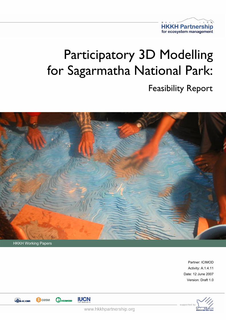
1 Executive summary
The Participatory 3-Dimensional Modeling (P3DM) integrates participatory resource mapping,
and spatial information to produce a stand-alone scaled relief model, which has proved to be a
user-friendly and a relatively accurate research, planning and management tool. This model is
constructed through the active participation of a given community with facilitation by mapping
experts and hence derives its name, Participatory 3-Dimensional Model.
It is easier to understand 3-dimensional (3D) models as compared to other types of maps as it
adds a third dimension which makes it easy for visualization and communication. With the
application of Participatory 3-Dimensional Modeling (P3DM) communities can better plan the
management of their resources because they will have more knowledge about resources
available.
The participatory approach to community management in SNP is not a new concept. There are
several activities in Sagarmatha region that involved the participation of the communities in the
planning and development. Through these exercises, communities understand the major
problems and provide them opportunity to find means to solve these problems. It is expected
that, local communities will have deeper understanding of the geography of the region,
improved communication skills and stronger cohesion and consensus among them. This activity
has the stronger linkages with CESVI.
2
2 Objectives of this document
The general objective of this document is to assess the feasibility of Participatory 3-Dimensional
Modeling (P3DM) in Sagarmatha National park (SNP) and to answer the basic questions on
how P3DM can be used in planning and management of the park. P3DM will be developed by
the communities and would result in a physical 3D representation of an area of the park. This in
turn would increase the understanding of the situation and qualities and strength of the
decision-making process of the communities of the region. Also the model would be a useful
means of information communications to the visitors.
The specific objectives are to:
- Introduce P3DM model, P3DM methodology.
- P3DM as a method to bring about cohesion and consensus among communities
- To prepare cost estimate of the model
3
3 The Participatory Approach in SNP
3.1 Background
The participatory approach to community management in SNP is not a new concept. The idea
of community participation in this region for protection is well established. In general terms it
can be seen that decentralization and empowerment of local organizations and people are the
key strategies to achieve an effective participation on local people in natural resources
management.
There are several activities in Sagarmatha region worth mentioning that involved the
participation of the communities in the planning and development. An example of such a project
is the one developed by The Mountain Institute (HDCG, 2004) in the upper Imja valley. This
project had the objective to conserve and restore the alpine ecosystems. Youth clubs, hotel
owners, tourist guide participated in the planning and later involved in the implementation of
activities. Through these exercises clear understanding of the major problems faced by the
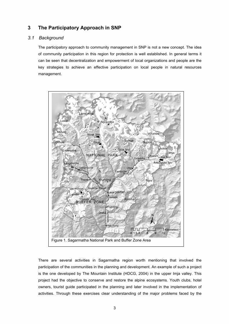
Figure 1. Sagarmatha National Park and Buffer Zone Area
4
community could be understood and the means to solve the problems could be explored.
Therefore, the people were then able to rank their expectations and to estimate a budget for the
activities chosen.
Realizing the benefits of the participatory 3D modeling the HKKH partnership project under the
second Detailed Operational Plan (DOP2) aims to carry out a feasibility of participatory activity
under activity A.1.4.11. Based on the previous similar experiences conducted by ICIMOD a
feasibility of developing a 3D model of SNP through a participatory workshop has been
assessed. The exercise would result in a physical 3D representation of an area of the park
developed by the communities that will then be a part of the SNP visitor center.
4 Participatory 3-Dimensional Modeling
4.1 Introduction
The participatory creation of maps, above and beyond their interpretation, started in the late
1980s. At that time, development practitioners were inclined to adopt Participatory Rural
Appraisal (PRA) methods such as sketch mapping (Mascarenhas et al. 1991) rather than the
more complex and time consuming scale mapping. In 1990s, with the diffusion of geographic
information systems (GIS), remote sensing based image analysis and application of global
positioning system (GPS) revolutionized the mapping technology. Later there were initiatives
taken to integrate geo-spatial information technologies and systems into communities. The
concept of Participatory Geographic Information Systems (PGIS) emerged where the geo-
spatial technologies were used for the community development for the empowerment of less
privileged communities. PGIS combines a range of geo-spatial information management tools
and methods. Participatory 3-dimentisonal modeling (P3DM) is one such method which can be
used to represent peoples’ knowledge in the physical 3 dimensional models. This model can be
used as an interactive vehicle for spatial learning, discussion, information exchange, decision
making and advocacy.
P3DM integrates indigenous spatial knowledge with data on elevation of the land and depth of
sea to produce stand-alone, scaled and geo-referenced relief models (Rambaldi et al). P3DM
main function is to generate spatially defined, geo-referenced and scaled information. P3DM
integrates participatory resource mapping, and spatial information to produce a stand-alone
scaled relief model, which has proved to be a user-friendly and a relatively accurate research,
planning and management tool. This model is constructed through the active participation of a
given community with facilitation by mapping experts and hence derives its name, Participatory
3-Dimensional Model. Based on the indigenous knowledge the informants use pushpins, yarns
(thread or wool) and paints to depict land use and land cover and other features. Generally
pushpins, yarns and paints are used to mark point feature, line feature and polygon features
respectively.
5
4.2 Why Participatory 3-Dimensional Modeling
It is easier to understand 3-dimensional (3D) models as compared to other types of maps like
GIS maps. A topographic map represents only two dimensions and is therefore not always easy
to interpret if the map represents hilly and mountainous terrain. 3-Dimensional Modeling adds a
third dimension which makes it easy for visualization. It is expected that local people would feel
comfortable and happy using 3D models to communicate with one another and with others who
do not know much about the area. Participatory 3-Dimensional Modeling (P3DM) can be useful
tool to gather spatial information for variety of purposes. Communities can better plan the
management of their resources because they will have more knowledge about resources
available. They can monitor the implementation of development projects, and resolve resource
conflicts within their own communities so they can respond better to problems. It empowers
people to plan effectively for themselves based on their needs. Participatory mapping can force
communities to confront the burning issues with regard to the management of natural
resources. This will raise local awareness.
The P3DM approach allows the villagers to participate in the entire process of 3D model
building though it is field intensive and requires much community time. P3DM acts as a visual
language and is a powerful medium for easing communication and overcome the language
barrier and creates common ground for discussion. This holds true particularly in regions like
Sagarmatha National Park where there are a blend of visitors speaking sixty different
languages. For them the model would be a source of visitor information system. Hence the
practice of P3DM allows people to share information and concerns.
4.3 Outcomes from Participatory 3-Dimensional Modeling
It is expected that following changes within the communities would occur in the region after
P3DM is applied.
- Deeper understanding of the geography of the region
Those who are not aware about the village geographical area would be able to get
themselves familiar with the spatial information of the village. P3DM would allow the people to
identify areas around the village and let them know the names of the creeks, rivers, forests,
watershed areas, the altitude and areas of household settlements.
- Improved communication and planning capacity of the communities
P3DM would be a reference to interact among different institutions of the community. This
would bring about different authorities to a common understanding towards better resource
management. With a clear visualization of the land through the P3DM the community would
know where exactly to construct terraces, roads/trails, areas for settlement, management of
watershed, conservation of forests, protection of water source, and demarcation of village
boundary.
- Stronger cohesion and consensus among the communities
6
Community will be brought together to work and to learn about protecting and preserving the
area.
- A physical model of the area will be developed which will be an attraction of the SNP visitor
centre. The model will serve as a base for visitor related information in addition to
information on environment and natural resources.
5 ICIMOD’s Experience in Participatory 3-Dimensional Modeling
5.1 Introduction
Participatory 3-dimensional Modeling (P3DM) models exercises have been conducted in the
villages where ICIMOD works with IFAD in Nokrek, Meghalaya, India. P3-D models are
effective tools for community-based natural resources' management and have been extensively
used by the communities for land allocation in shifting cultivation, natural resource use, village
planning, and for negotiating with government officials about services and the development of
natural resources. An original model was up-scaled by the project and the communities, and is
now available in twelve villages. The model has also been successfully applied in the villages
surrounding ICIMOD's Demonstration and Training Centre in Godavari and in Mustang, Nepal
for participatory natural resources' management in watersheds and rangelands.
5.2 Participatory 3-Dimensional Modeling in Godawari
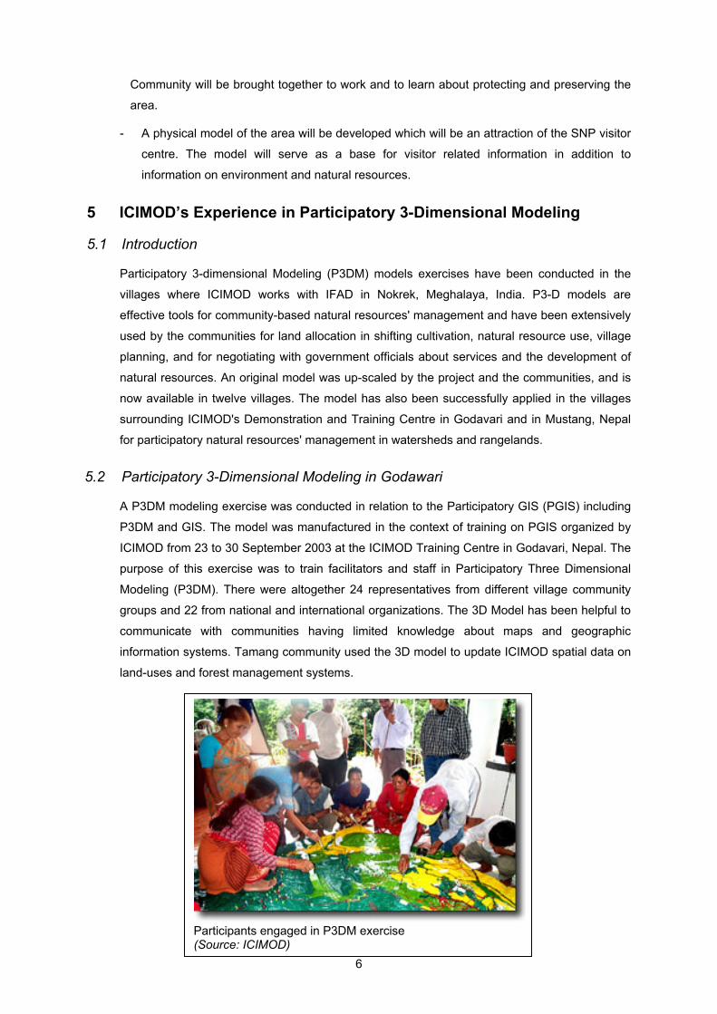
A P3DM modeling exercise was conducted in relation to the Participatory GIS (PGIS) including
P3DM and GIS. The model was manufactured in the context of training on PGIS organized by
ICIMOD from 23 to 30 September 2003 at the ICIMOD Training Centre in Godavari, Nepal. The
purpose of this exercise was to train facilitators and staff in Participatory Three Dimensional
Modeling (P3DM). There were altogether 24 representatives from different village community
groups and 22 from national and international organizations. The 3D Model has been helpful to
communicate with communities having limited knowledge about maps and geographic
information systems. Tamang community used the 3D model to update ICIMOD spatial data on
land-uses and forest management systems.
Participants engaged in P3DM exercise (Source: ICIMOD)
7
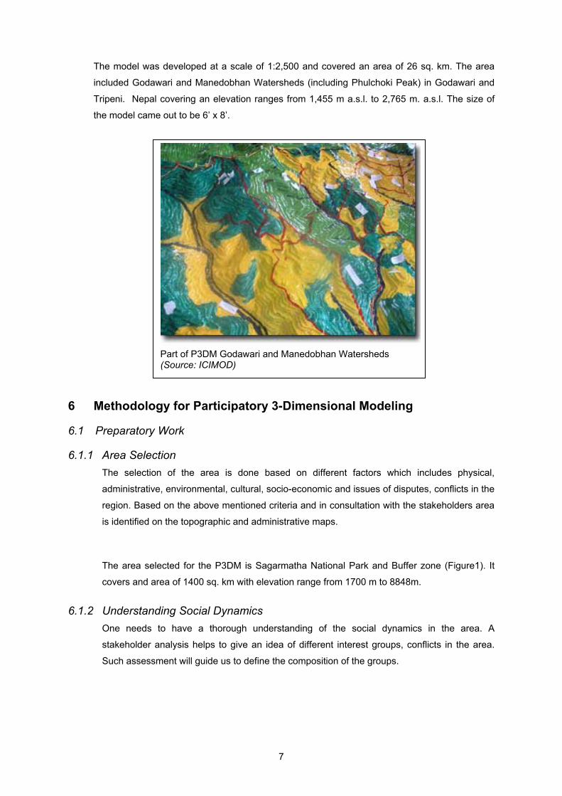
The model was developed at a scale of 1:2,500 and covered an area of 26 sq. km. The area
included Godawari and Manedobhan Watersheds (including Phulchoki Peak) in Godawari and
Tripeni. Nepal covering an elevation ranges from 1,455 m a.s.l. to 2,765 m. a.s.l. The size of
the model came out to be 6’ x 8’.
6 Methodology for Participatory 3-Dimensional Modeling
6.1 Preparatory Work
6.1.1 Area Selection The selection of the area is done based on different factors which includes physical,
administrative, environmental, cultural, socio-economic and issues of disputes, conflicts in the
region. Based on the above mentioned criteria and in consultation with the stakeholders area
is identified on the topographic and administrative maps.
The area selected for the P3DM is Sagarmatha National Park and Buffer zone (Figure1). It
covers and area of 1400 sq. km with elevation range from 1700 m to 8848m.
6.1.2 Understanding Social Dynamics One needs to have a thorough understanding of the social dynamics in the area. A
stakeholder analysis helps to give an idea of different interest groups, conflicts in the area.
Such assessment will guide us to define the composition of the groups.
Part of P3DM Godawari and Manedobhan Watersheds (Source: ICIMOD)
8
6.1.3 Groundwork at Community Level This step in the preparatory work will introduce the concept of participatory 3-dimensional
modeling to the various stakeholders.
6.1.4 Planning for the Logistics A venue sufficiently large enough to accommodate the community to prepare the model
should be located in the area. Transportation, accommodation and catering should also be
organized.
6.1.5 Participants Selection It is preferred that the first category of participants be students from locally based institutions.
The second category of participants may be included from those identified by stakeholders
having vested interest in the area. These participants may be representatives from indigenous
groups, economic sectors, government and non-governmental organizations.
6.1.6 Gathering Secondary Information A pre-requisite for P3DM is contour lines. It is cost effective if contour lines are available in
digital formats. If not the contour lines will have to be digitized which will relatively increase
the cost of the model. An alternative solution will be to enlarge the topographic maps using
the digital photo copiers and to trace the contour lines. This will relatively deteriorate the
quality of the model in terms of accuracy.
Apart from contour lines, additional information needs to be gathered which includes
demography, land use, vegetation cover, infrastructure and whatever information that may be
relevant to the facilitators to understand the physical, social and economic characteristic of
the area.
6.1.7 Preparing Base Map Scale and size of the map
Fewer details can be shown on the model with small scale as compared to model prepared
on larger scale. Larger scale 3-dimensional is more comprehensive and of more use to the
planning process. Considering that Participatory 3-D Modeling aims at providing a visual aid
capturing the details of the terrain, the larger the scale the better. Larger the scale of the
model larger would be its size. Therefore when making the choice of the scale, size of the
model should be taken into account for enough space in which to physically construct and
store the model and the need for the accuracy. The ideal scale for 3-D modeling is 1:10,000
or larger. So in and ideal case if the reference map is at 1:50,000-scale, it needs to be re-
scaled to 1:10,000 to make it suitable for the activity. At 1:10,000, one centimeter on the
model corresponds to 100 meters on the ground - a pretty comfortable scale for people to
pinpoint salient features.
9
Taking into consideration the size of the area and the location where the model is going to be
stored it is proposed that the P3DM model be constructed at a scale of 1:25,000. The size of
the model will come out to be about 6 ‘X 8’. The vertical scale may be the same as the
horizontal scale. But for exaggeration purposes vertical scale may differ from horizontal scale.
To enhance the visual perception of the ruggedness of the landscape or to highlight erosion
hazards or accessibility, the vertical scale could be exaggerated by nearly double the
horizontal scale, say 1:10,000.
Contour Interval
Generally, 1:50,000-scale reference maps feature 20-m contours, which conveniently may be
applied to a 1:25,000 model.
Preparing customized base map
Once scale, size and contour interval is fixed then a base map is generated. It is wise to plot
the sequence of contour lines in different color. Elevation labels should be placed close to the
contour lines.
6.1.8 Procurement of Materials One of the most critical tasks in building the 3-dimensional model is to assemble the materials
required for it. Various map symbols with a range of coding items should be available in
sufficient quantity to mark the many variables that people may want to record in the model.
Procurement is done after the first assessment of the features that may be encountered in the
area.
Map symbols should be chosen understanding the existence of different types of point, line
and polygon features. Some guidelines to code and display the features are given in table 1.
Table 1: Means to display the features on the model
Features Means of display
Points Water bodies (springs and waterfalls); mountain peaks; social infrastructures (municipal/district halls, administrative centres, day-care centres, schools, rural health centres, hospitals, bus stops); cultural places (churches, burial caves, cemeteries, sacred areas, etc); tourist establishments; human settlements (households); scenic spots, turtle nesting sites; diving spots; docking sites, and others.
Map and push pins of diverse colours, shapes and sizes.
Lines Watercourses; communication ways (roads, bridges, trails); social infrastructures (rural water supplies), classifications (e.g. watershed classifications), boundaries (administrative units, protected area, ancestral domains,
Yarns of different colours.
10
land status, areas where destructive methods are employed, fish breeding and spawning areas; feeding grounds of endangered species; fishing grounds; features of the seabed like coral reefs differentiated into “intact” and “damaged”, seaweed areas, etc); borders, coordinates (grid).
Polygons Water bodies (rivers, creeks, lakes, springs and waterfalls); cultural places (cemeteries, sacred areas, etc); tourist establishments; land uses (rice fields, vegetable gardens, sugarcane and coconut plantations, orchards, reforestation sites, residential areas, resettlement areas, etc.); land covers (different types of forest cover, grassland, brushland, mangrove, etc.); landslides and bare land; and others.
Acrylic paint – different colours.
Attributes Names, annotations Text on labels
6.2 Assembling the Model
6.2.1 Orienting Participants Participants should be oriented on the mechanics of model construction. They should be
introduced with the rudiments of map reading. It would be an added advantage if they know in
advance what sort of material is being used, the scale of the model and the contour interval.
6.2.2 Organizing Work Participants should be divided into groups to do specific tasks.
6.2.3 The Base Table It is recommended to have a wooden base table to rest the model. The table should be of the
size to match the base map and strong enough to support the weight of the model. One side
of the base table should be narrow enough to permit easy access to all sections of the model.
6.2.4 Tracing, Cutting and Pasting The contour lines are traced, cut and pasted on top of the previous one maintaining proper
geo-references. The outcome is a scale relief model with base contours of the landscape.
6.3 Transposing Information
6.3.1 Composing People’s Knowledge It is very important that the participants are well aware of the legends they are going to use
before they mark the features on the model. Participants are then invited in groups to locate
the water courses, mountain peaks, islets, roads, trails, social infrastructures and other
landmarks they use to orient themselves when moving around within their domains. Pins,
yarns and colour paints are used to mark point, line and polygons features respectively.

11
6.3.2 Secondary Information After the informants have completed the transference of mental maps and cross checking,
other secondary information can be added to the model. Some secondary information are
administrative boundaries, park boundaries, placing the grid.
6.4 Handing Over of the Model
After the completion of the model the ownership of the model has to be formally transferred to
the community. The model is never complete and it needs to be regularly updated with the
latest information. The model has to be entrusted to an entity having the means and the
commitment to safeguard and maintain it, and to make it accessible to those who would like to,
use it, update it with the latest information and correct previously entered information.
In the case of SNP, the model will be handed over to the visitor information centre which will be
maintained by Park Office in collaboration with the local community.
12
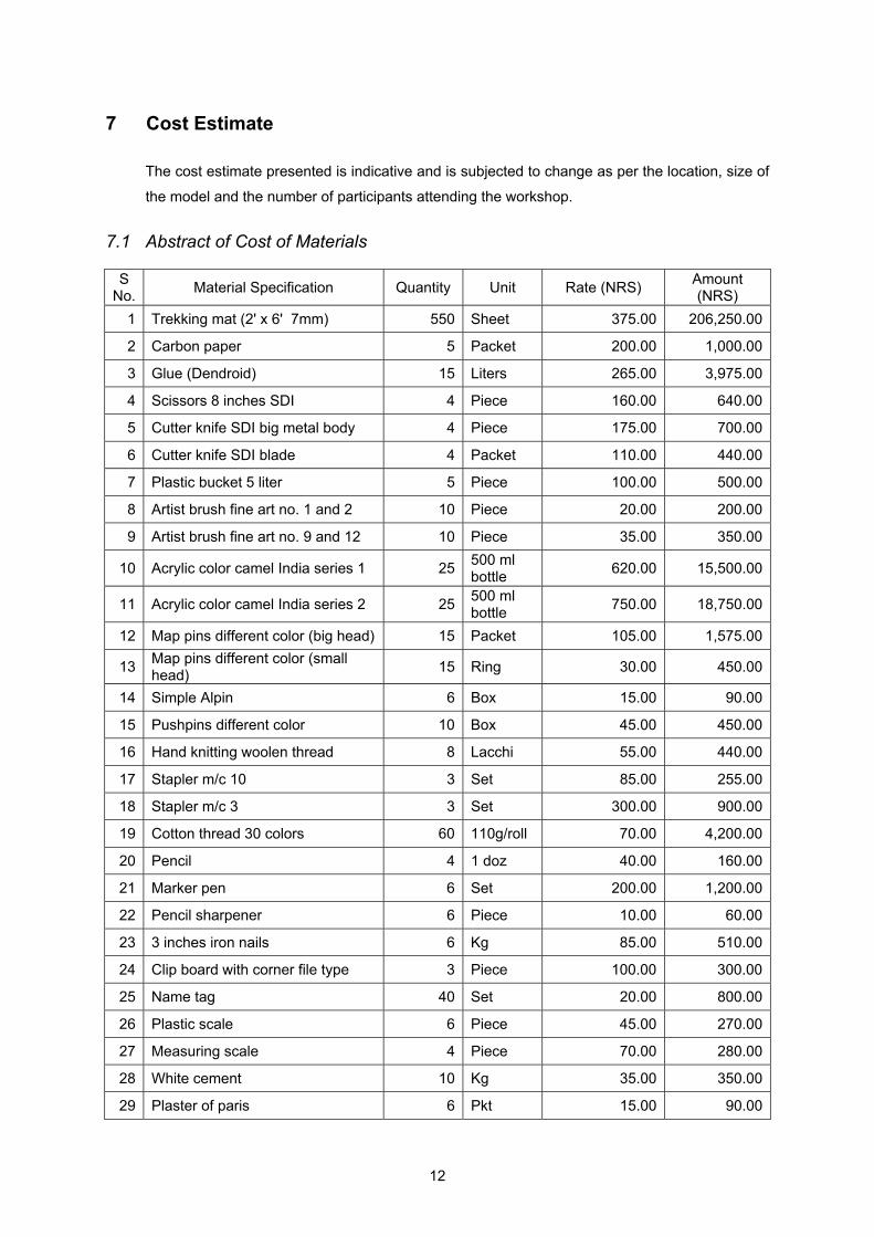
7 Cost Estimate
The cost estimate presented is indicative and is subjected to change as per the location, size of
the model and the number of participants attending the workshop.
7.1 Abstract of Cost of Materials
S No. Material Specification Quantity Unit Rate (NRS) Amount
(NRS) 1 Trekking mat (2' x 6' 7mm) 550 Sheet 375.00 206,250.00
2 Carbon paper 5 Packet 200.00 1,000.00
3 Glue (Dendroid) 15 Liters 265.00 3,975.00
4 Scissors 8 inches SDI 4 Piece 160.00 640.00
5 Cutter knife SDI big metal body 4 Piece 175.00 700.00
6 Cutter knife SDI blade 4 Packet 110.00 440.00
7 Plastic bucket 5 liter 5 Piece 100.00 500.00
8 Artist brush fine art no. 1 and 2 10 Piece 20.00 200.00
9 Artist brush fine art no. 9 and 12 10 Piece 35.00 350.00
10 Acrylic color camel India series 1 25 500 ml bottle 620.00 15,500.00
11 Acrylic color camel India series 2 25 500 ml bottle 750.00 18,750.00
12 Map pins different color (big head) 15 Packet 105.00 1,575.00
13 Map pins different color (small head) 15 Ring 30.00 450.00
14 Simple Alpin 6 Box 15.00 90.00
15 Pushpins different color 10 Box 45.00 450.00
16 Hand knitting woolen thread 8 Lacchi 55.00 440.00
17 Stapler m/c 10 3 Set 85.00 255.00
18 Stapler m/c 3 3 Set 300.00 900.00
19 Cotton thread 30 colors 60 110g/roll 70.00 4,200.00
20 Pencil 4 1 doz 40.00 160.00
21 Marker pen 6 Set 200.00 1,200.00
22 Pencil sharpener 6 Piece 10.00 60.00
23 3 inches iron nails 6 Kg 85.00 510.00
24 Clip board with corner file type 3 Piece 100.00 300.00
25 Name tag 40 Set 20.00 800.00
26 Plastic scale 6 Piece 45.00 270.00
27 Measuring scale 4 Piece 70.00 280.00
28 White cement 10 Kg 35.00 350.00
29 Plaster of paris 6 Pkt 15.00 90.00
13
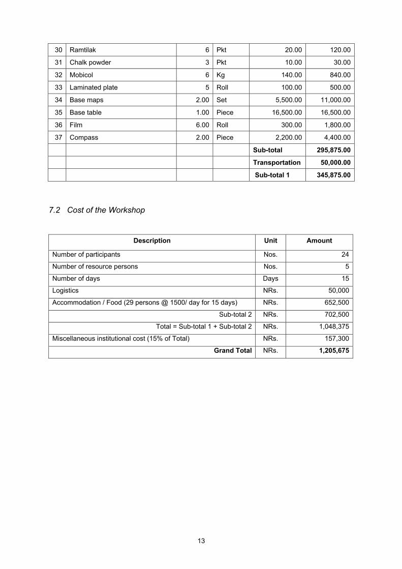
30 Ramtilak 6 Pkt 20.00 120.00
31 Chalk powder 3 Pkt 10.00 30.00
32 Mobicol 6 Kg 140.00 840.00
33 Laminated plate 5 Roll 100.00 500.00
34 Base maps 2.00 Set 5,500.00 11,000.00
35 Base table 1.00 Piece 16,500.00 16,500.00
36 Film 6.00 Roll 300.00 1,800.00
37 Compass 2.00 Piece 2,200.00 4,400.00
Sub-total 295,875.00
Transportation 50,000.00
Sub-total 1 345,875.00
7.2 Cost of the Workshop
Description Unit Amount
Number of participants Nos. 24
Number of resource persons Nos. 5
Number of days Days 15
Logistics NRs. 50,000
Accommodation / Food (29 persons @ 1500/ day for 15 days) NRs. 652,500
Sub-total 2 NRs. 702,500
Total = Sub-total 1 + Sub-total 2 NRs. 1,048,375
Miscellaneous institutional cost (15% of Total) NRs. 157,300
Grand Total NRs. 1,205,675

14
References
Rambaldi, G., Kyem, PAK., McCall, M., Weiner, D. Participatory Spatial Information Management and Communication in Developing Countries Yolando, CA., Adrian, M., Thingreiphi, NG., Chinaorar, H. 3 Dimensional Model in Land Use Management, The Ukhrul District Experience Rambaldi, G., Callosa-Tarr, J. Participatory 3-Dimensional Modelling: Guiding Principles and Applications Caroli, P., Daconto,G., Giacco, S. Sagarmatha National Park situation analysis: stakeholders, management system, participatory tools in use and preliminary capacity building assessment