part xx mountain empire subregional · pdf filepart xx mountain empire subregional plan san...
TRANSCRIPT
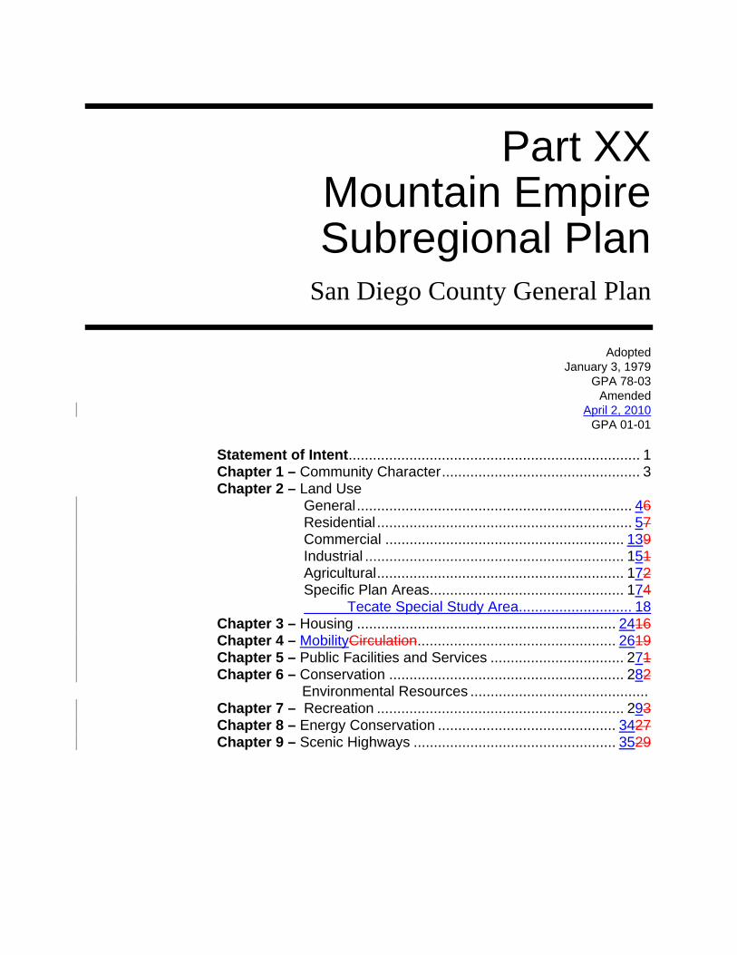
Part XX Mountain Empire Subregional Plan
San Diego County General Plan
Adopted
January 3, 1979 GPA 78-03
Amended April 2, 2010
GPA 01-01
Statement of Intent........................................................................ 1 Chapter 1 – Community Character................................................. 3 Chapter 2 – Land Use
General.................................................................... 46 Residential ............................................................... 57 Commercial ........................................................... 139 Industrial ................................................................ 151 Agricultural............................................................. 172 Specific Plan Areas................................................ 174 Tecate Special Study Area............................ 18
Chapter 3 – Housing ................................................................ 2416 Chapter 4 – MobilityCirculation................................................. 2619 Chapter 5 – Public Facilities and Services ................................. 271 Chapter 6 – Conservation .......................................................... 282 Environmental Resources ............................................ Chapter 7 – Recreation ............................................................. 293 Chapter 8 – Energy Conservation ............................................ 3427 Chapter 9 – Scenic Highways .................................................. 3529

Appendix A – Resource Conservation Areas............................... 37 Policy Code Explanation ........................................................ 4239
CERTIFICATIONE OF ADOPTION I hereby certify that this Plan, consisting of a map and this text, as amended by General Plan Amendment (GPA) 95-01, Item 2, is the Mountain Empire Subregional Plan, Section II, Part XX, of the San Diego County General Plan, and that it was considered by the San Diego County Planning Commission on the 28th day of October, 1994. Edward J. Ferraro, Chair Attest: Robert R. Copper, Secretary (Acting) I hereby certify that this Plan, consisting of a map and this text as amended by General Plan Amendment (GPA) 95-01, is the Mountain Empire Subregional Plan, Section II, Part XX, of the San Diego County General Plan, and that it was adopted by the San Diego County Board of Supervisors on the 11th day of January 11, 1995. Dianne Jacob, Chairwoman Attest: Thomas J. Pastuszka, Clerk of the Board Text Adopted January 3, 1979, GPA 78-03 Latest Amendment January 11, 1995, GPA 95-01 A complete history of the amendments to this Plan, both map and text, is available at the Department of Planning and Land Use.
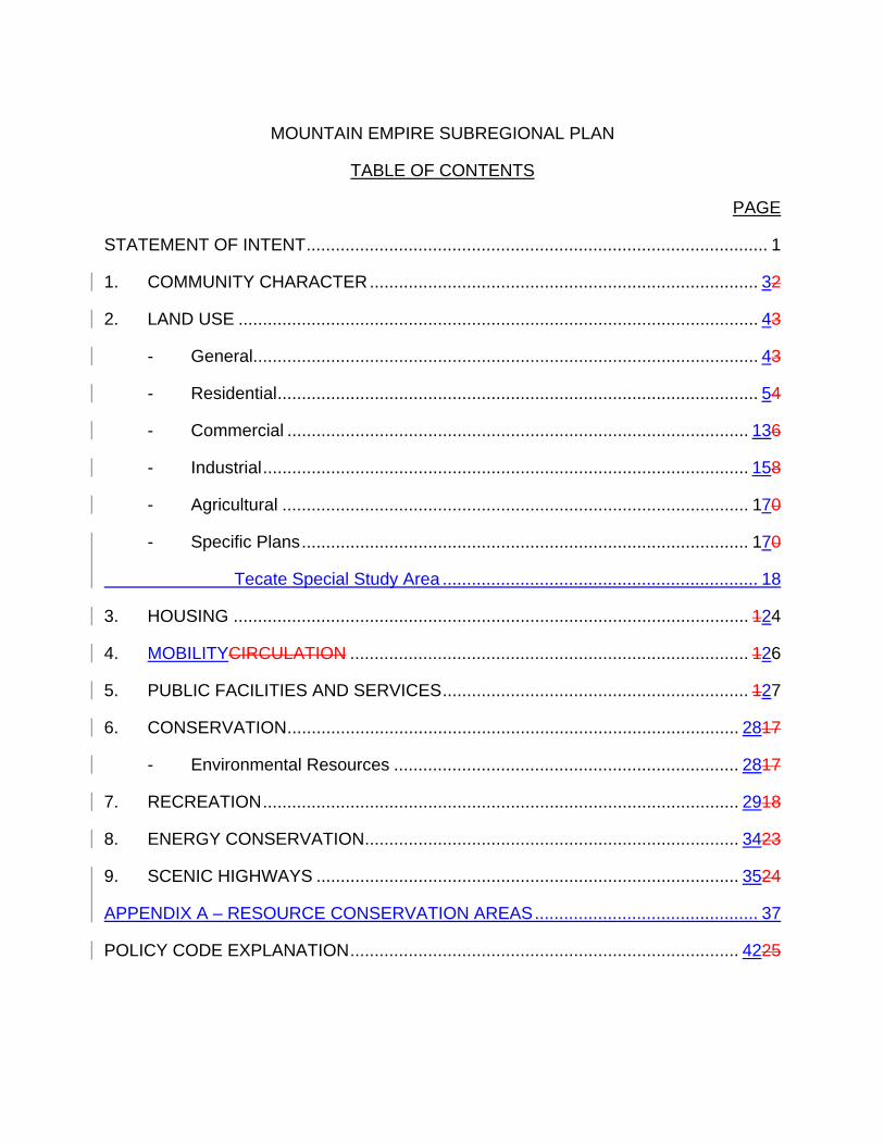
MOUNTAIN EMPIRE SUBREGIONAL PLAN TABLE OF CONTENTS PAGE STATEMENT OF INTENT............................................................................................... 1 1. COMMUNITY CHARACTER................................................................................ 32 2. LAND USE ........................................................................................................... 43 - General........................................................................................................ 43 - Residential................................................................................................... 54 - Commercial ............................................................................................... 136 - Industrial.................................................................................................... 158 - Agricultural ................................................................................................ 170 - Specific Plans............................................................................................ 170 Tecate Special Study Area ................................................................. 18 3. HOUSING .......................................................................................................... 124 4. MOBILITYCIRCULATION .................................................................................. 126 5. PUBLIC FACILITIES AND SERVICES............................................................... 127 6. CONSERVATION............................................................................................. 2817 - Environmental Resources ....................................................................... 2817 7. RECREATION.................................................................................................. 2918 8. ENERGY CONSERVATION............................................................................. 3423 9. SCENIC HIGHWAYS ....................................................................................... 3524 APPENDIX A – RESOURCE CONSERVATION AREAS.............................................. 37 POLICY CODE EXPLANATION................................................................................ 4225
1
MOUNTAIN EMPIRE SUBREGIONAL PLAN STATEMENT OF INTENTIntroduction A goal is a purpose or ultimate end towards which effort is directed. It represents a value to be sought which is general and timeless. A policy is a principle which guides the allocation of County resources towards prescribed outcomes consistent with the goals. The goals and policies which follow reflect a thoughtful analysis of the Mountain Empire Subregion and are a statement by the citizens and the Board of Supervisors as to the kind of total living environment that should be achieved. It is recognized that legal and economic limitations may hinder the complete attainment of these goals. The fact that the goals may not be completely achieved should in no way hinder every effort to achieve them to the greatest extent possible. The Land Use Categories and Designations contained in this subregional plan are consistent with those found in tThe Regional Land Use Element of the General Plan. This element can be referred to for complete descriptions, the Land Use Maps and definitions of these Land Use Categories and Designations. There are ten six five other elements of the General Plan besides the Regional Land Use Element. They are Housing, MobilityCirculation, Safety, Seismic Safety, Scenic Highways, Conservation and Open Space (combined), Recreation, and Noise, Conservation and Energy. These subject areas provide the basic structure by which this Subregionalcommunity Plan is organized. Each chapter of this Subregionalcommunity Plan represents a subject area which coincides with an adopted element of the General Plan. The purpose of addressing these elements within the Subregionalcommunity Plan is to ensure that the goals and policies formulated by eachthe community in the Subregion will be compatible with those found in the General Plan, or, if conflicts exist, they can be readily identified and reconciled. In addition, some policies found in the General Plan Elements can be more relevant for one community than for others, and further elaboration or refinement may be appropriate in one case while in another the existing policies might be adequate. The policies contained in this Subregionalcommunity Plan should be regarded as applications of broad General Plan policies which are designed to fit the specific or unique circumstances existing in the individual communities. Where the existing General Plan element adequately addresses an individual community's situation, the subject area may be omitted or a notation to reference the element may be included so that the adopted goals and policies relating to the subject area may be taken into account.
2
The Mountain Empire Subregion contains six areas with their own unique
identities, but they are similar in many natural characteristics such as topography, water resources, and environment. These areas are the five Subregional Group Areas:, Tecate, Potrero, Boulevard, Campo/ Lake Morena, Jacumba and the Mountain Empire Balance, the remainder of the plan area. Although the Policies in this section apply generally to the entire Subregion, the Subregional Group Areas of Boulevard and Potrero have adopted specific vision statements, goals and policies affecting their Subregional Group Areas. These Subregional Group Area Plans are adopted to cover those specific areas as chapters in this Mountain Empire Subregional Plan, and serve as the primary community plans for those areas. Additionally, Jacumba has adopted a vision statement and along with Campo/Lake Morena and Tecate have the option in the future to develop specific goals and policies. A Special Study Area (SSA) applies to a large portion of Tecate which will be implemented through an amendment to the Mountain Empire Subregional Plan text and map, rezoning as necessary for consistency with that amendment, and adoption of a Specific Plan.
3
1. COMMUNITY CHARACTER GOAL ENCOURAGE THE DEVELOPMENT OF LAND IN A MANNER THAT
REINFORCES THE UNIQUE IDENTITY OF THE MOUNTAIN EMPIRE SUBREGION AND ITS COMMUNITIES.
FINDINGS The Mountain Empire Subregion contains six areas with their own unique
identities, but they are similar in many natural characteristics such as topography, water resources, and environment. These areas are Tecate, Potrero, Boulevard, Campo, Jacumba and the remainder of the plan area.
Because it is a port of entry, the Tecate Subregional Group Area has certain land
uses which are unique. Its proximity to Tecate, Mexico, has given rise to intensive uses which are generally nonresidential and need greater planning which will be achieved through implementation of a SSA, an amendment to the Mountain Empire Subregional Plan text and map, rezoning as necessary for consistency with that amendment, and adoption of a Specific Plan and which have been established without the benefit of a Country Town Regional Category or a Specific Plan.
The Potrero Subregional Group area has unique natural characteristics such as:
excellent air quality; a gently sloping valley floor bisected by Potrero Creek; the surrounding mountains which offer view sites of the valley; and proximity to the border and a growing population in Tecate, Mexico.
The Campo/Lake Morena Subregional Group aArea consists of three clusters of
development. Campo, Lake Morena and Cameron Corners have historically been rural in character. The need to provide services and to house the population has not, as yet, presented a threat to the rural life style.
The Boulevard Subregional Group aArea developed as a linear, highway-oriented
community and that orientation has been altered by the construction of Interstate 8. As a result, there now is a need to reassess the existing land use pattern. Due to easy accessibility to Interstate 8 and its link to the metropolitan area, new growth may occur in this rural area.
The Jacumba Subregional Group Area is unique in both its natural and manmade
settings and has a long history of human occupation. These natural attributes - hot springs, desert environment, and clean air - attracted many residents and brought about the town's development.
4
The northern portions of the Subregion consist primarily of lands such as the Anza-Borrego State Park, agricultural preserves and other public lands. There exists very little pressure to urbanize and no significant growth is anticipated.
POLICIES AND RECOMMENDATIONS 1. Request that CalTrans improve community identity by providing signing that
contains the name of Boulevard at the freeway off-ramp entrances to that community. [TDPW]
2. Development proposals within Country Rural Village BoundariesTowns
should avoid the removal of mature trees. [RPP] 2. LAND USE ELEMENT GENERAL GOAL PROVIDE A LAND USE PATTERN CONSISTENT WITH THE SUBREGIONAL
POPULATION FORECAST. FINDINGS The Mountain Empire Subregion is expected to grow from its present population of
approximately 3,6006,4721 to some 1016,500 3402 persons by the year 20052030. There is a need to provide sufficient land area and density to accommodate this projected growth within the Subregion. The distribution of this population projection will likely result in the following pattern:
Tecate, approximately 255 persons Potrero, approximately 660 persons Campo, approximately 3,700 persons Boulevard, approximately 2,100 persons Jacumba, approximately 3,800 persons All residents of the Mountain Empire Subregion are aware of the importance that
must be given to protecting the unique quality of the area's natural resources. Existing trees, rock outcroppings, hillsides, and meadows are significant resources that contribute to the character and beauty of the Subregion.
The Mountain Empire Subregion is totally dependent on groundwater resources;
surface runoff is meager and too variable to be used as a water supply and importation of water is not a viable option for the foreseeable future. The availability of groundwater varies from community to community but, generally,
1 SANDAG, 2008 estimate 2 SANDAG, forecast for 2030
5
future development will require eight (8) acrelarge minimum lot sizes to ensure long term availability of groundwater.
There have been increased demands on law enforcement agencies along the
international border in recent years and a greater need for law enforcement and fire protection activities is anticipated in future years.
POLICIES AND RECOMMENDATIONS 1. The landforms of the Subregion are an important environmental resource
that should be respected in new development. Hillside grading shall be minimized and designed to blend in with the existing natural contours. [RPP]
2. Create a buffer area of one hundred and fifty (150) feet in width along the
international boundary line inclusive of the existing sixty-foot (60') Public Reserve owned by the Federal Government. [RAP, PP]
3. Apply a ninety (90') foot setback within which no new permanent building
may be built northerly of the existing sixty (60') foot Public Reserve line. Where such ninety (90') foot setback can be shown to adversely impact a property, the owner may apply for a waiver from complying with the setback as provided for in Section 7060 of The Zoning Ordinance. [PP]
RESIDENTIAL GOAL PROVIDE A LAND USE PATTERN WHICH WILL ACCOMMODATE THE
FORECAST POPULATION INCREASE WHILE RETAINING THE RURAL CHARM OF THE PRESENT LIVING ENVIRONMENT.
FINDINGS The Mountain Empire Subregion is generally characterized by large lot single
family residential development outside the Country TownsRural Villages, and generally undeveloped meadows, open spaces, and hillsides. The ability to experience large open spaces and views to distant hills is essential to preserving the Subregion's present quality of life.
POLICIES AND RECOMMENDATIONS 1. Apply the a Rural Village Boundary Country Town Regional Land Use
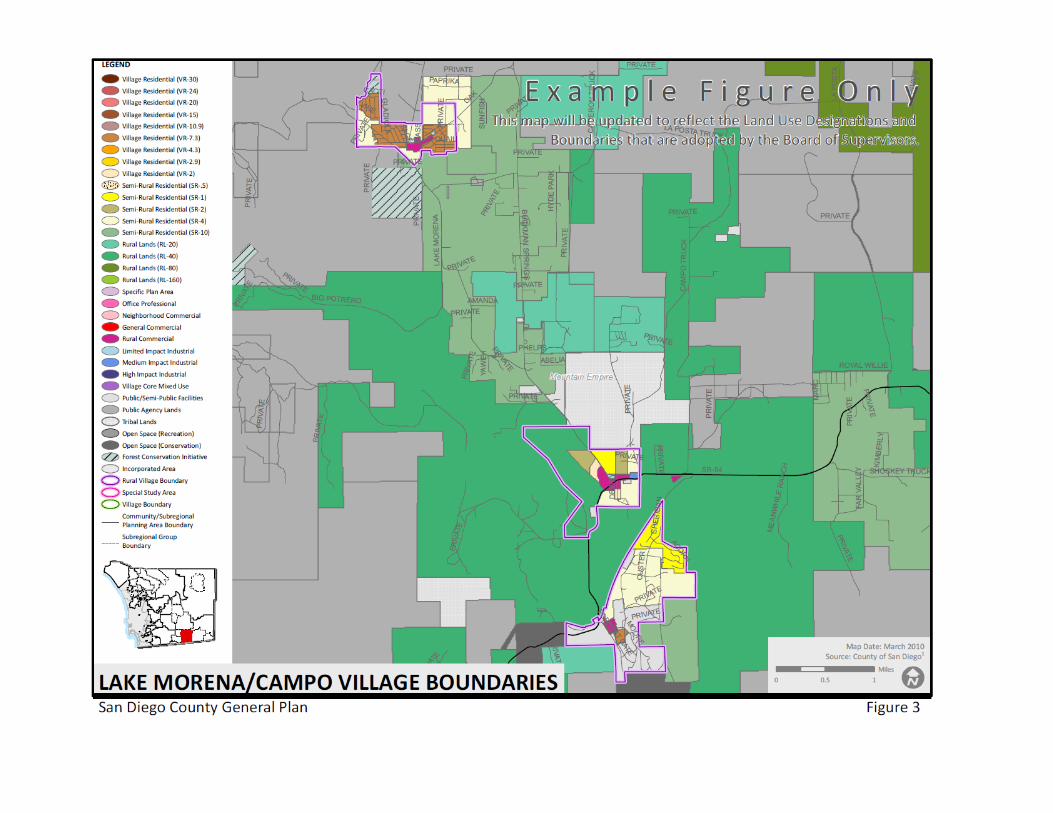
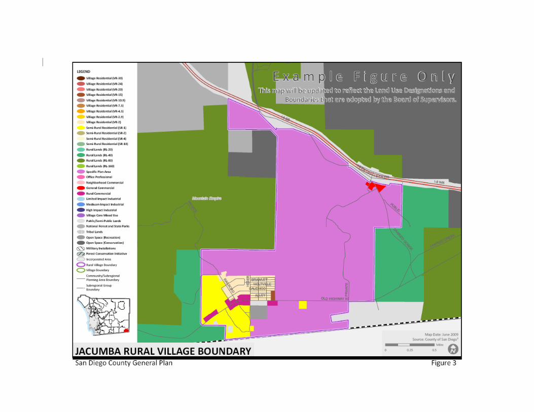
Category to each of the following historically significant settlements in this subregional area. , shown in figure 3.
Existing Country Towns: Proposed Country Towns: Campo, Jacumba, Lake Morena, Boulevard, Cameron Corners, and Potrero., and Tecate) [AP] 2. Preserve the rural atmosphere of the Subregion by blending roads into the
natural terrain. [RDPW, PP]
6
3. Maintain the existing rural life style by continuing the existing pattern of
residential and agricultural uses on large lots outside of the Country Town Regional CategoryRural Villages. [PP]
4. Provide for a land use pattern in accordance with Board of Supervisors
Groundwater Policy I-77 which is characterized by large lot sizes (5, 8 or larger acre minimum where appropriate). [P]
54. All development proposals shall demonstrate a diligent effort to retain
significant existing natural features characteristic of the community's landscape. Existing topography and landforms, drainage courses, rock outcroppings, vegetation and views shall be incorporated, to the maximum extent feasible, into the future development of the land. [RPP]
65. Residential site design shall avoid: [R] - level grading of entire lots without respect for existing landforms or
neighboring developments; - removal of oaks without careful consideration; - blocking existing significant views through the property and within the
property; - diverting natural drainage patterns unless no other alternative is
available; and - creation of a landscape foreign to that of surrounding sites. 7. Landscaping should emphasize the use of natural drought resistant plant
materials. 86. Minimize the visual impacts of hillside developments with buildings, retaining
walls and other improvements deferring to the natural landforms and kept to as low a profile as possible. [RPP]
97. Graded hillsides should approximate the surrounding natural hills. Slope
blbanks should be softened by contoured grading of fill at the top and toe of the slope. [DPW, PP]
108. Waive concrete curbs, gutters, and sidewalk requirements in new
subdivisions to ensure compatibility with existing rural developments. [DPW] 119. Preserve open space areas such as steep slopes and canyons, floodplains,
agricultural lands, meadows and unique scenic views and vistas by clustering residential development away from such areas. through the clustering provisions of Regional Land Use Element Policy 1.4; and the lot
7
size averaging and planned development provisions of The Zoning Ordinance. Clustering of residential development, however, is prohibited on FCI affected lands as stipulated in the (23) National Forest and State Parks Land Use Designation in the Land Use Element. [R]
102. Buffer residential areas from incompatible activities which create heavy
traffic, noise, lighting, odors, dust and unsightly views. [RPP] 113. Avoid all extensive or severe grading to preserve the natural terrain. [DPW,
PP]
8
9
10
11
Figure 3

12
This page intentionally left blank
13
COMMERCIAL GOAL PROVIDE FOR THE ORDERLY GROWTH OF BUSINESS AND
PROFESSIONAL SERVICES AND OPTIMIZE CONVENIENCE FOR LOCAL AND HIGHWAY-RELATED SHOPPING NEEDS.
FINDINGS Commercial businesses are generally concentrated in the Country TownsRural
Villages where they are located in small neighborhood shopping centers or are contiguous to one or more businesses; however, Tecate’s commercial businesses will be providing goods and services for the population of Tecate, Mexico with the goal of reducing vehicle traffic on State Route 94.
There exists a need to promote further concentration of commercial uses in most
communities within the Subregion. The amount of commercial acreage provided in each community is based upon
the size of the forecasted support population and the recognition that, for the foreseeable future, most properties in the Subregion will be served by individual septic systems and wells. The supporting population for commercial development in Tecate, USA is located across the border in Tecate, Mexico.
POLICIES AND RECOMMENDATIONS 1. Protect areas designated for commercial development from encroachment
by incompatible non-commercial uses. [RAP, PP] 2. Discourage requests which may lead to mixed residential in commercial
areas except those residential uses which are secondary to a commercial use. [RPP]
3. Upgrade existing "strip" commercial by providing landscaping and clearly
defined parking and access areas. [RPP] 4. To create shade for the comfort of pedestrians, design the south-facing
facades of businesses to include arcades, porches or trellised walkways. [RPP]
5. Cooperate with the federal and state governments at the time the Port of
Entry at Tecate is redesigned. [RAP] 6. Create nodes of commercial development at major intersections and
Highway 8 off-ramps. [R] 7. Ensure that business sites are of adequate size to provide off-street parking.
[P] 86. Limit new commercial uses to sites within the Country Rural Village
BoundariesTown Regional Category excepting highway-related uses. [P, R]
14
97. Ensure that all development be planned in a manner that provides adequate
public facilities prior to or concurrent with need.In order to ensure the long-term quality and availability of groundwater in the Tecate area, a water and sewer district needs to be established before properties designated Commercial on the Plan Map can be fully developed. [GEN]
10. Apply the R.C. (Residential Commercial) Use Regulation to properties in the
Tecate Planning Area designated as Commercial on the Plan to allow limited commercial uses until said properties connect to a water and sewer district. [AP]
11. In the Tecate planning area, a property must be connected to a water and
sewer district before being considered for a Rezone to a Commercial Use Regulation. [RPP]
108. Soften the visual impact of parking areas by screening all parking areas from
street view, by interrupting continuous rows of parking spaces with planting, and by creating planted canopies over parking areas to lessen heat build-up. [RPP]
119. Parking lots for Commercial uses may utilize permeable surfacing materials
such as gravel or decomposed granite in order to minimize surface runoff and maximize groundwater recharge. [RPP]
120. Commercial parking areas adjacent to residentially-zoned property must be
completely screened from view of the residential property with a 72 inch high solid fence, wall, hedge or other dense plant material. The following plant species would be appropriate if a vegetative screening is to be utilized: [RPP]
a. San Diego Mountain Mahogany (Cercocarpus minutiflorus); 4'-15'. b. Toyon (Heteromeles arbutifolia); 8'-15' with flowers and berries. c. Hollyleaf cherry (Prunus ilicifolia); 8'-20' with flowers and berries. d. California scrub oak (Quercus dumosa); 8'-10'. e. Coffeeberry (Rhamnus California); 5'-15' with flowers and berries. To provide an effective screening these plants should be planted four to five
feet apart. These suggested plants are all native evergreens which naturalize after two growing seasons (two winters). They will require water during the summer in order to ensure adequate adaptation, and are not
15
effective in areas which are over 4,000 feet in elevation. 113. Plan for land use development that would contribute to the cultural and
economic relationship between Tecate, USA and Tecate, Mexico. 124. In Tecate, explore the potential for development of agricultural services and
agri-tourism to promote East County agricultural products. INDUSTRIAL GOAL PROVIDE A LAND USE PATTERN WHICH WILL PERMIT THOSE KINDS OF
INDUSTRIAL USES WHICH WILL NOT DETRACT FROM THE RURAL CHARM AND LIFESTYLE OF THE SUBREGION.
FINDINGS Parcel size and, transportation, and utility service availability are typical
constraints to industrial development. As a result, the Mountain Empire Subregional Plan Area is not expected to attract much general industrial development.
Existing industrial development is generally characterized by open storage and
parking areas that are not landscaped or screened from the street or neighboring properties.
While, aAdditional industrial development is not compatible with the goal of
maintaining the rural character inof the Subregion, . Tthe Tecate SSACountry TownRural Village is an important exception. Tecate is located across the international border from Tecate, Mexico, which has a population of approximately 76120,0003. Such a support population with its large, highly competitive labor pool presents many opportunities for business and industry. Industrial development in Tecate shall be governed the SSA and the Tecate Specific Plan.
The east and west water basins that drain into Tecate can support a level of water
use equivalent to what is needed for approximately 500 dwelling units. POLICIES AND RECOMMENDATIONS 1. Preserve those existing industries which are compatible with a rural lifestyle.
[GEN] 2. New industrial development should be clean, non-polluting and
complementary to a rural area. [GEN] 3. Industrial development in Tecate should not adversely affect the excellent air
quality of the Potrero area. [RPP] 3 Based on 2005 census, http://en.wikipedia.org/wiki/Tecate
16
4. Protect areas designated for industrial use from encroachment by
incompatible, non-industrial uses. [R] 54. In order to ensure the long-term quality and availability of groundwater in the
Tecate area, a water and sewer district needs to be established before properties designated Industrial on the Plan Land Use Map can be fully developed. [GEN] Ensure that all development be planned in a manner that provides adequate public facilities prior to or concurrent with need.
65. New industrial development should consider all views into the property from
public streets, adjacent properties, and residences on nearby hills. [RPP] 76. Concentrate future industrial development in those Rural Village Country
Town areas already designated or planned for industrial uses. [RPP] 87. Apply heavy industrial designations sparingly to avoid uses which can create
noise, dirt, air pollution, other forms of pollution, and congestion. [AP] 9. Apply the M50 (Basic Industrial) Use Regulation to properties in the Tecate
Planning Area designated as Industrial on the Plan to allow limited industrial uses until said properties connect to a water and sewer district. [P]
10. In the Tecate Planning Area no Rezone to the M52, M54, M58 or
Commercial Use Regulations will be allowed without proof that properties have been connected to a water and sewer district. [R]
11. Deny future industrial or commercial development which adversely impacts
the Mountain Empire Subregional area, such as wind turbine generators, for any of the following reasons: [R]
a) Safety of the general public; b) Unmitigated visual impact on the rural environment; c) Noise pollution emanating from the site exceeding 65 (decibels) dBs at
the property line, as it creates great human discomfort and adversely affects the tranquillity of the rural environment;
d) Such development may lead to the economic devaluation of
contiguous properties. 128. Upgrade existing industrial developments by providing landscaping and
clearly defined parking and access area; and soften the visual impact of parking areas for new development by providing landscaped screening and by interrupting continuous rows of parking spaces with plantings of shade trees. [RPP]
17
190. Parking lots for industrial uses may utilize permeable surfacing materials such as gravel or decomposed granite in order to minimize surface runoff and maximize groundwater recharge. [RPP]
104. Industrial parking areas adjacent to residentially-zoned property must be
completely screened from view of the residential property with a 72 inch high solid fence, wall, hedge or other dense plant material. [RPP]
1125. Large unbroken expanses of wall shall be avoided. If this is not
possible, architectural details and/or landscaping shall be utilized to soften straight unbroken facades. [RPP]
AGRICULTURAL GOAL ENCOURAGE THE EXPANSION AND CONTINUANCE OF AGRICULTURAL
USES IN THE SUBREGION. FINDINGS While the Subregion is essentially rural in character, the topography, lack of water
and poor soil quality offer little opportunity for instituting any large scale agricultural operations. The most significant agricultural enterprise, in the past, has been at the Ketchum Ranch near Jacumba, but this has ceased operation and it is currently planned for development as a residential project under a Specific Plan.
Small scale agricultural opportunities are scattered throughout the Subregion.
Three are some orchards, chicken ranches and grazing operations; however, any expansion or increase in the number of these within the foreseeable future is unlikely.
There are currently 55,578246 acres of Agricultural Preserves in the Subregion. POLICIES AND RECOMMENDATIONS Study and determine the possible benefit from promoting agricultural uses in the
Subregion. Explore the potential for development of agricultural services and agri-tourism in Tecate to promote East County agricultural products. [IAWM]
SPECIFIC PLAN AREAS KETCHUM RANCH SPECIFIC PLAN AREA The Ketchum Ranch Specific Plan proposes a multi-use concept, a residential
community and recreational and visitor-oriented commercial uses on approximately 1,300 acres next to Jacumba. The proposed Specific Plan would be developed in two (2) phases.
Phase 1 would develop the southern 653 acres of the Ranch, within the Jacumba
Village CenterCountry Town, with 1,110 units and various support and

18
neighborhood commercial and recreational uses which may include: a golf course, equestrian trails, club house, tennis courts, swimming pools and other residential-orientated recreational uses. Phase 1 would also include a sewage treatment facility, and may include a hotel and visitor-serving recreational uses in the northern portion of the Specific Plan Area. The proposed sewage treatment facility and trunklines shall be sized to serve future residents of the Ketchum Ranch Specific Plan Area and existing residents of Jacumba Country Town.
Phase 2 would develop the northern 694 acres with residential, and light industrial
and commercial uses. Phase 2 would be deferred for a minimum of three years or until the Jacumba Country TownVillage Center is expanded to include the northern portion of the Ranch.
The Ketchum Ranch Specific Plan proposal shall create a community in harmony
with the existing town of Jacumba and provide services to the existing residents of Jacumba. It will also be sensitive in its design to the natural and historical resources of the Jacumba area. Adequate provisions shall be made to prevent periodic flooding originating at the Mexican border.
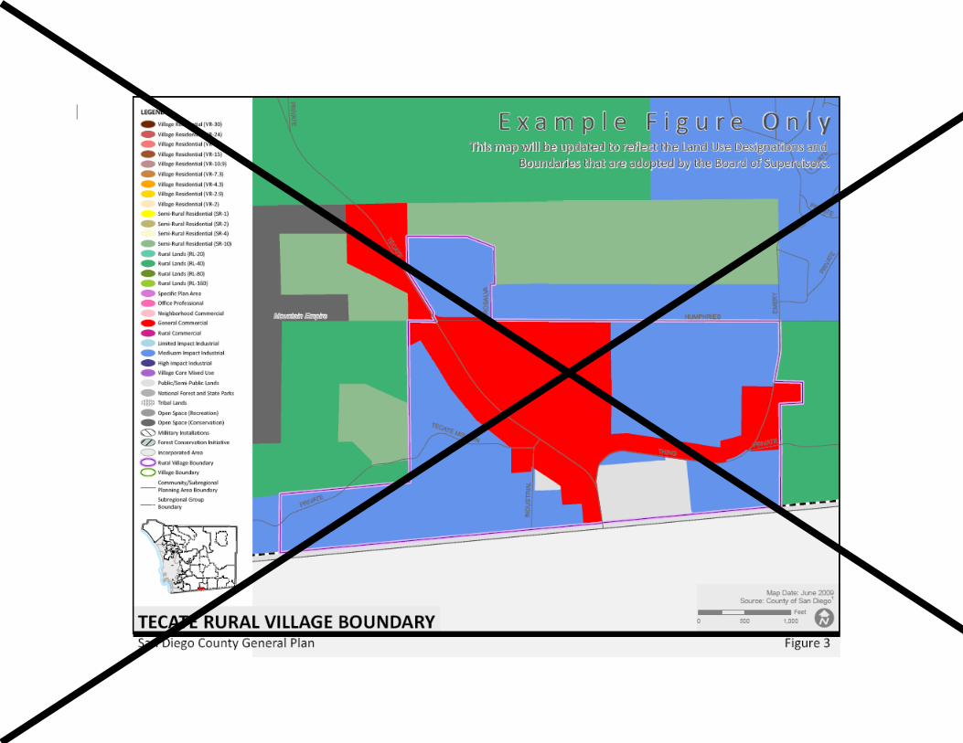
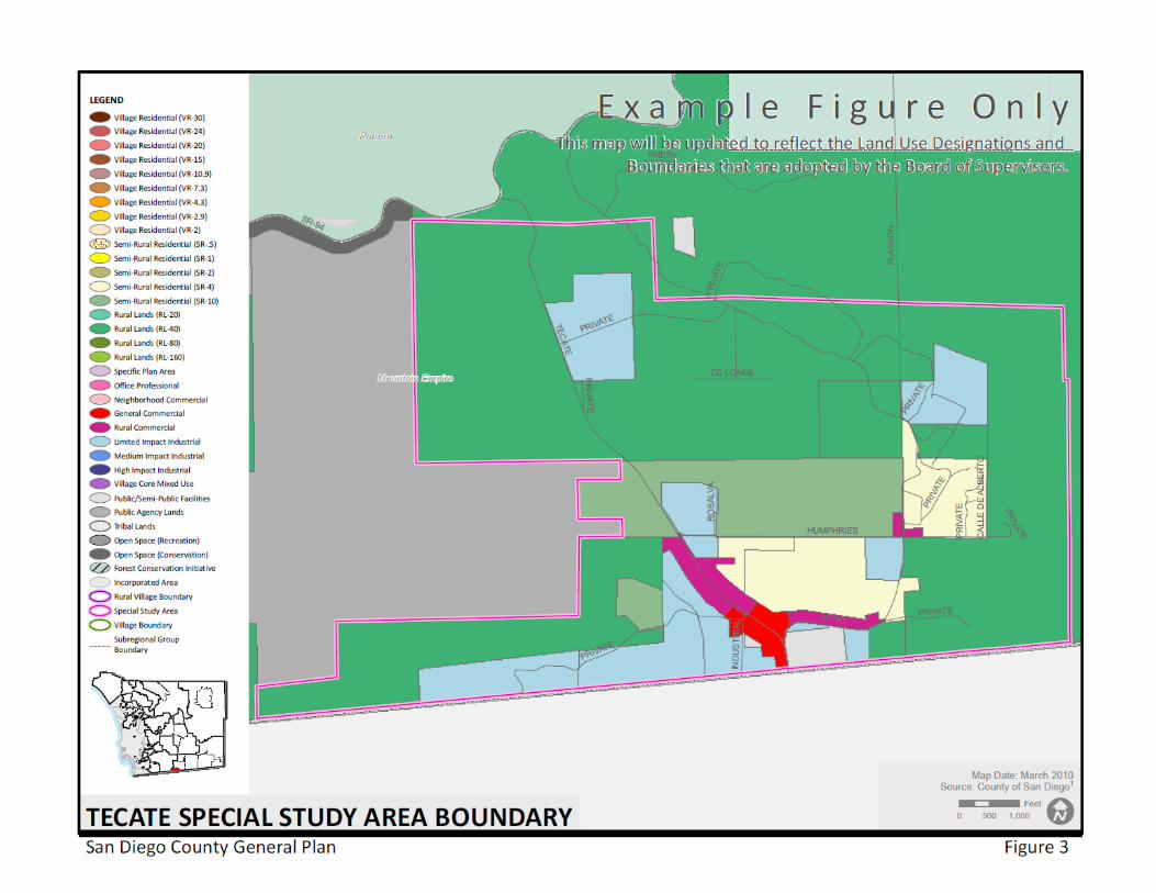
TECATE SPECIAL STUDY AREA
Tecate, USA and Tecate, Mexico lie within the Tecate Valley and share many resources, including air quality, water, and weather. The Tecates are connected to State Route 94 and the international border by State Route 188. The Tecate Valley has retained much of its national beauty which has been recognized by the designation of State Route 188 as a scenic corridor. The Tecates are physically separated by the international border and the border fence. The uses of land on each side of the border currently are significantly different. Tecate, USA is dominated by trucking, storage and other border-related uses, with a very small residential component. Tecate, Mexico has a population of more than 100,000 residents. Many residents of Tecate, Mexico and the surrounding area drive through Tecate, USA and westerly along State Route 94 to the urban areas of San Diego County (such as Rancho San Diego and the eastern portions of Chula Vista) to purchase goods and services not readily available in stores where they live. As a result, State Route 94 is heavily traveled between those urban areas and Tecate, causing traffic congestion and safety concerns, along with a number of environmental impacts. The Tecate SSA is intended to create a cross-border community and to promote development of Tecate, USA as an International Trade Community with commercial and industrial uses intended to provide goods and services that compliment the needs of the residents of Tecate, Mexico. Establishing Tecate, USA as an International Trade Community provides an
19
opportunity to redevelop the existing portions of Tecate in proximity to the International border as well as to develop the large, generally flat area northerly along State Route 188 in a coordinated manner while also reducing vehicle traffic on the heavily traveled State Route 94. The reduction in traffic would also have the beneficial effects of reducing energy consumption, air pollution, and reduce the generation of greenhouse gases.
The vision for the Tecate, USA community is based upon developing commercial and industrial uses that reduce vehicle traffic reaching State Route 94 rather than developing residential dwelling units which are readily available in Tecate, Mexico. The Goals and Policies outlined herein for the Tecate SSA are designed to allow the development of commercial uses largely not available to residents of Tecate, Mexico. In this regard, the SSA includes a vehicle trip limit of approximately 65,000 Average Daily Trips (ADT) ends. Sufficient roadway capacity will need to be provided within Tecate, USA to ensure adequate property access. Planning and development shall be coordinated with the federal government to ensure that sufficient border crossing capacity is maintained.
The Tecate Valley has retained much of its natural beauty which should be considered during the implementation of the Tecate SSA. The SSA should include design criteria that respects the SR 188 scenic corridor. Additionally, the SSA should identify the infrastructure needed to support the land use designations and logical phasing. Currently, Tecate, USA does not have adequate infrastructure to serve the proposed SSA; therefore, the SSA implementation will consider which facilities will be needed to serve the community and how those facilities will be provided. All property development will comply with County requirements and standards related to water and wastewater facilities.
Land Use Plan Issue SSA 1.1 A mix of commercial uses needs to be developed to reduce trips into the urban areas of San Diego County. While the topography near the Port of Entry limits development of large flat building pads, it does provide an opportunity for development of uses that compliment the Port of Entry. North of this border area, along State Route 188, is a large generally flat area which represents an excellent opportunity for larger commercial development. A companion component for the development of Tecate, USA will be fostering industrial land uses that emphasize International Trade, and that develop land uses which generate increased sales and property tax revenues while lessening the need for typical public services such as schools, parks, and other population-based
20
services.
Goal SSA 1.1 A Land Use Plan with a mix of commercial and industrial uses tailored to reduce trips into the urban areas of the County of San Diego by developing as a complement to the existing populations in Tecate, Mexico and revitalize the existing underutilized development
Policy SSA 1.1.1 Encourage commercial development in areas with appropriate topography and road access, as a complete plan that integrates revitalization of existing underutilized sites and allows growth in appropriate areas.
Policy SSA 1.1.2 Require the development plan to include design guidelines that will create a distinctive entry to Tecate USA, and will unify the land uses across the multi-ownership.
Goal SSA 1.2 Development of an integrated transportation plan that includes a road network to accommodates traffic from automobiles, pedestrians and other modes on a regional and local level to tie the development to Tecate, Mexico.
Policy SSA 1.2.1 Require the development plan to include traffic analysis and establish land uses based on the Kimly-Horn Traffic Study (Attachment A) to capture existing through traffic and limit traffic on State Route 94 to 65,000 average daily trips from originating from the SSA.
Policy SSA 1.2.2 Periodically review traffic conditions relative to new development in Tecate USA to demonstrate that uses are achieving the desired interaction with Mexico and limiting the traffic burden on State Route 94. Make adjustments to the land plan and intensities where necessary to better achieve the desired balance between growth within Tecate while limiting the effects on State Route 94.
Policy SSA 1.2.3 Arrange retail uses in nodes such that visits to multiple businesses can be made on foot. As development intensity in Tecate increases, consideration should be given to a shuttle service that would transport shoppers between the border crossing and retail establishments in Tecate, USA.
Implementation of the SSA will require a General Plan/Mountain Empire Subregional Plan Amendment, zoning implementation, and a Specific Plan which will describe and designate land uses, design guidelines, and infrastructure consistent with the goal of creating an International Trade Community. The inclusion of this SSA for the Tecate community in this Subregional Plan is
21
considered a County-initiated General Plan Amendment, although privately processed, that does not require further approval as a Plan Amendment Authorization by the Board of Supervisors to begin it’s planning process in compliance with the Goals and Policies in this Subregional Plan. The SSA within the Subregional Plan on figure 3 anticipates requiring a General Plan Amendment, Subregional Plan Amendment, Rezone, and the adoption of a Specific Plan. There are no time limits or prohibitions relative to the processing and approval of said General Plan/Mountain Empire Subregional Plan Amendment, rezoning and/or Specific Plan. The Goals and Policies and Recommendations of the Tecate SSA are adopted within this Subregional Plan.
BIG COUNTRY SPECIFIC PLANNING AREA (0.25) Description of Area Big Country Specific Planning Area 0.25 includes 3,455 acres, 2,280 acres of which are owned in fee and the balance of which is under purchase agreement by Big Country Development Corporation. This holding comprises all the contiguous, privately held property at the north end of Ribbonwood Road (SA 210), approximately 2.4 miles north of Interstate 8 Freeway and the communities of Boulevard, Live Oak Springs and Jacumba. Project Background The original Big Country Specific Plan (SP 83-06) was approved by the Board of Supervisors to allow 296 residential estate homesites on the aforesaid 2,280 acre fee ownership. A Zone Reclassification to the S88 Use Regulation was also granted along with approval of Tentative Subdivision Map TM 4437. Subsequently, under new ownership the property has been enlarged, as noted above, to complete a logical planning area bounded by Bureau of Land Management and Indian Reservation lands. The Big Country Specific Planning Area (0.25) also controls an adjacent 16,000 acres under grazing lease from the Bureau of Land Management. Project Description The original Big Country Specific Plan was approved with exclusively residential estate homesites serviced by individual wells and septic waste disposal systems. The proposed new project includes provision of recreational and transient habitation facilities in addition to permanent residential uses. A variety of residential styles is planned along with additional lakes, an equestrian center, riding and hiking trails and commercial uses adequate to serve the new recreation oriented concept for Big Country Specific Planning Area (0.25). Conditions
22
The Specific Planning Area shall be developed under the following conditions. A. General 1. Maximum overall average residential density will be 0.25 dwelling units per
acre since all of the property is designated (18) Multiple Rural Use and has an overall slope of less than 25%.
2. All goals, objectives and policies of the Mountain Empire Subregional Plan
shall apply. 3. Design of residential and non-residential uses shall include provisions to
mitigate nuisance factors that could impact residential development both within and adjacent to this project.
B. Specific 1. Residential a. Careful attention shall be given to harmony of residential use types,
their design and locations, with existing homesites near and adjacent to the southerly portion of the development.
b. Design of homesites should be such that landscaping and building
locations blend with natural terrain features and compliment the rustic rural character of the area.
2. Commercial a. Neighborhood commercial activities at appropriate scale shall be
located along collector roads. b. Commercial recreation facilities shall be located with care to minimize
impacts to residential uses both within and adjacent to Big Country. While such uses may be complimentary to uses allowed within the adjacent Lark Canyon offroad vehicle and camping area, no offroad vehicle uses will be allowed within Big Country. If direct access is provided to the Lark Canyon use area, it shall be designed and operated so as to avoid the intrusion of offroad vehicles on private property.
c. Animal husbandry uses in conjunction with the Bureau of Land
Management grazing lease shall be perpetuated through design of suitable ranch estate homesites contiguous to adjacent leased lands.
3. Conservation
23
a. Project design shall conserve significant natural resources as identified
in the Environmental Impact Report (EIR) through open space, recreation use areas or other appropriate means.
b. A system of open space linkages and buffers and archaeological
preservation areas shall be provided within the specific planning area. 4. Public Facilities a. Design shall be such that implementation of public facilities including
roads, sewers, water, etc., shall be provided as necessary with a minimum of grading.
b. The Specific Plan shall include the means by which all necessary
public facilities shall be financed and provided including: 1) transportation access, including roads and their drainage
improvements; 2) liquid and solid waste collection, treatment and disposal; 3) public school facilities; 4) fire protection; 5) parks; and 6) any other public facilities and services necessary to fulfill the
requirements of public agencies affected by the Specific Plan. LAZARE SPECIFIC PLAN AREA If the Specific Plan for this area is adopted: 1. All Specific Plan proposals shall be presented to the residents of Jacumba
for review at a Jacumba Sponsor Group Meeting. 2. New development shall be compatible with the historical character and scale
of the existing Jacumba Country Town. 3. Two nearby faults make this Specific Plan Area (SPA) susceptible to
geologic hazards due to earthquakes. A site-specific geologic study should be conducted which would recommend methods of mitigating such impacts.
4. Cluster development to avoid the steep and rocky areas in the western and
northwestern portions of the SPA. 5. Minimize grading on steep and rocky slopes.

24
6. Conduct a site-specific archeological study. This study should recommend preservation measures, and where applicable, should map, collect, excavate and analyze artifacts. Development should avoid recognized sites as much as possible.
7. Provide for the preservation of the three significant historical sites located in
the SPA. At least one site should be preserved as is, while the other two might be integrated into a viable redevelopment theme.
8. Install a package sewer treatment plant capable of handling the waste
product of the SPA, or connect the development to the treatment plant proposed for the Ketchum Ranch SPA.
3. HOUSING GOAL ENSURE THAT ADEQUATE, AFFORDABLE SHELTER IS PROVIDED FOR ALL
RESIDENTS OF THE MOUNTAIN EMPIRE SUBREGION IN A WAY THAT IS CONSISTENT WITH ITS RURAL CHARACTER.
FINDINGS The Housing Element of the General Plan sets forth goals, policies and action
programs which are designed to adequately provide for the housing needs of all economic segments of the County. In most cases, the policies and action programs are targeted toward the larger, more urbanized communities; however, there are some policies which involve issues affecting all parts of the County.
The Tecate SSA designation is based upon developing commercial and industrial land uses that reduce vehicle traffic on State Route 94 through providing goods and services desired by the more than 120,000 residents of Tecate, Mexico.
Housing for low-income households and emergency housing for the homeless are
of regional concern but such housing has been traditionally provided in the more urbanized sections of the County. However, as the communities in the Mountain Empire Subregion grow or as socioeconomic changes occur, problems could arise if housing for these groups is not planned.
It is anticipated that the housing needs of households with incomes at or below
80% of the median in the Subregion will be met through a planned expansion in the supply of manufactured housing. Policy 3.8 of the Regional Land Use Element of the General Plan provides for the location of mobilehome parks in rural areas at urban densities. Associated with this policy is Board of Supervisors Policy I-101 which is intended to aid staff and the developer in identifying significant issues prior to the initiation of a "3.8" application.
The Housing Element, utilizing data compiled by San Diego Association of

25
Governments (SANDAG), provides estimates on how many more housing units would be necessary to meet the demands of the Subregion's growing population up to the year 2000. The demand for additional multi-family housing units for the communities in the Subregion is forecast as follows:
Potrero 8 units Campo 27 units Boulevard 14 units Jacumba 10 units While these do not appear to be significant increases, changes to the Plan Map
should be made to parcels appropriate for multi-family residential use in order to accommodate this projected need.
The lack of adequate housing for the County's farm workers is of great concern;
however, the Subregion does not have significant labor- intensive agricultural activities.
POLICIES AND RECOMMENDATIONS 1. Take those steps necessary to ensure that the private sector is able to
provide for the housing needs of the Subregion's low and moderate income households. [P]
2. Designate appropriate parcels within the Subregional communities for multi-
family or mixed use development. [P] 3. Identify and inventory areas with underused infrastructures when revising
this subregional plan. This could be instrumental in minimizing housing costs, as well as actualizing economics from infilling. [P]
4. Study and determine if there is a need for farm employee housing in the
Subregion. [I] 5. Study and determine if there is a need for creating emergency housing for
the homeless in the Subregion. [I] 6. Provide incentives for builders or developers to voluntarily incorporate
energy conservation features, which go beyond the State Title 24 mandated measures or which address different areas, in new residential construction or during improvements to existing housing. [R]
7.6. If a project is in conformance with the General Plan and if the Subregion has
had a certified EIR done for it, then the EIR may be used as a master environmental assessment. This would provide the applicant with a central
26
source of current information on potential regional impacts, including the cumulative and growth inducing impacts of the project, making it necessary to address only site specific impacts. [PP, R]
8. Modify and update building codes and standards so that they reflect current
housing needs, and eliminate or reduce unnecessary or outmoded restrictions. [B]
9. The demand for low income housing anticipated for the Potrero Valley
Planning Area can be accommodated at the Picnic Twin Lakes Trailer Park. [I]
4. MOBILITYCIRCULATION GOAL IMPROVE THE TRANSPORTATION SYSTEM TO PROVIDE FOR SAFE AND
EFFICIENTLY MAINTAINED TRAVEL THROUGHOUT THE SUBREGION WHILE MAINTAINING THE RURAL ATMOSPHERE AND NATURAL BEAUTY OF THE AREA.
FINDINGS Transportation facilities have significant design, location, and environmental
impacts on community character. Primary access to the Mountain Empire Subregion is provided by Interstate 8, a
limited access freeway with interchanges at: - Buckman Springs Road; - Cameron Road and Old Highway 80; - Crestwood Road and Old Highway 80; and - Ribbonwood Road (Highway 94) and Carrizo Gorge Road. Secondary access to the Subregion is provided by State Route 94 and Old
Highway 80 which serve to connect the Country TownsRural Villages of the Subregion.
Buckman Springs Road is the principal north-south access road within the
Subregion. The current road network can accommodate the existing and planned increases in
population without encountering capacity problems. Large portions of the Subregion are not served by roads. Access to public lands is not required; and, for those areas in private ownership, local roads will be built as development occurs. In general, traffic volumes generated by existing and proposed land use designations will not warrant any addition to, or expansion of, MobilityCirculation Element roads, with the possible exception of SR-188 along with improvements to SR-94 to accommodate implement the traffic reducing developmentland uses
27
planned for the Tecate Subregional Group Area.. Some sponsor community groups have identified traffic safety and parking
problems within their communities which should be addressed. POLICIES AND RECOMMENDATIONS 1. Discourage on-street truck parking in the Country TownRural Village areas.
[GEN] 12. Request CalTrans to prohibit trucks one ton and over from parking on State
Route 188. [DPW] 23. Consider prohibiting trucks of one ton and over from parking on Thing and
Emery Roads in Tecate. [DPW] 34. Request CalTrans to study the safety aspects of SR-94 in the vicinity of
Tecate Road. [DPW] 5. PUBLIC FACILITIES AND SERVICES GOAL PROVIDE THE FACILITIES AND LEVEL OF SERVICE NECESSARY TO
SATISFY THE NEEDS OF THE SUBREGION. FINDINGS San Diego Gas and Electric (SDG&E) maintains a 69 KV overhead transmission
line that runs through the middle of the Boulevard planning area. In addition, the Southwest Powerlink transmission line runs west and east through the entire Subregion. SDG&E has substation facilities located in Boulevard and Cameron Corners. It is possible that development within the vicinity of these power transmission facilities can have an effect upon SDG&E's ability to patrol, maintain, and repair them.
POLICIES AND RECOMMENDATIONS 1. Maintain unobstructed access to and along the path of existing power
transmission facilities and lines. 2. Any proposed grading, improvements or other encroachments to the
substation or transmission rights-of-way must be reviewed by SDG&E. 3. Any alteration of drainage patterns affecting the substation or transmission
line rights-of-way should be reviewed and approved by SDG&E.
28
4. Uses proposed for property adjacent to substations or transmission line
rights-of-way should be reviewed for possible impacts to the power facilities and vice versa.
6. CONSERVATION ENVIRONMENTAL RESOURCES GOAL ENSURE THAT THERE IS CAREFUL MANAGEMENT OF ENVIRONMENTAL
RESOURCES IN THE AREA IN ORDER TO PREVENT WASTEFUL EXPLOITATION OR DEGRADATION OF THOSE RESOURCES AND TO MAINTAIN THEM FOR FUTURE NEEDS.
FINDINGS The Subregion contains a variety of different plant and animal habitats, as well as
numerous rare and endangered plant and animal species. Residents recognize the native oaks as a significant historical, aesthetic and
ecological resource which contributes to the distinctive character of many areas of the Mountain Empire Subregion.
Important geological resources are also present which include: a) An assortment of land formations, some of which have scenic value; b) Groundwater resources; and c) Soils of biological significance. There are significant limitations to groundwater resources, and sewage disposal
capabilities are affected by certain soil characteristics. Numerous archaeological and historical sites have been identified in the
Subregion which attests to a rich history of human habitation. POLICIES AND RECOMMENDATIONS 1. All development shall demonstrate a diligent effort to retain as many native
oak trees as possible. [RPP] 2. Encourage Ssewer districts should to implement a wastewater reclamation
program in areas where groundwater is not abundant. [PAP] 3. Avoid the construction of artificial drainage structures; utilize natural
channels and streambeds and require that runoff and drainage be used for groundwater recharging where applicable. [F]
29
43. Floodways shall be maintained in their natural state unless findings can be made that a threat to public safety exists. [GEN]
5. Discourage the exportation of more than one acre foot of groundwater from
the Potrero basin to areas outside the Potrero watershed. [W, R] 64. The dark night sky is a significant resource for the Subregion and
appropriate steps shall be taken to preserve it. [RPP] 75. Development shall not adversely affect the habitat of sensitive plant and
wildlife species or those areas of significant scenic value. [RPP] 68. The Jacumba Hotel should be restored if at all possible. [RAP, PP] 7. RECREATION It is the policy of the Board of Supervisors that the Recreation Chapter of the
Mountain Empire Subregional Plan shall provide for meeting park needs of the community in accordance with the overall guidelines of the General Plan all subregional plans shall include a Recreation Element which sets forth goals, policies, priorities, standards and general locations for parks. (Board Policy No. F-26). The recreation component of the General Plan is incorporated in the Conservation and Open Space Element. The following is intended to give direction and guidelines for providing and fulfilling the requirements of park and recreation needs for the citizens of the Mountain Empire Subregion.
GOAL SUPPORT RECREATIONAL OPPORTUNITIES TO MEET COMMUNITY NEEDS
AND ENRICH THE LIVES OF ALL RESIDENTS BY ESTABLISHING A BALANCED SYSTEM OF RECREATION FACILITIES AND SERVICES.
FINDINGS The County Local Park Planning Area for the Mountain Empire exceeds the
boundaries of the Subregion. The communities of Descanso and Pine Valley are also served by the Laguna/Mountain Empire Local Park Planning Area. For this reason, park facilities and development priorities for Descanso and Pine Valley are included in this Recreation Element.
Existing Regional Park and Recreation Facilities4 John Lyons - Lake Morena Park - 3,250 acre lakefront park with facilities for
camping, fishing, hiking and entrance to the Pacific Crest Trail. As funds become available, additional water related activities may be developed.
4 Does not include facilities identified in Subregional Group Area sections (Lake Morena / Campo and Potrero)
30
Potrero Park - 60 acres of regional facilities within this 115 acre park. Facilities
include group and individual camping, hiking trails, a self-guided nature trail and access to all day use facilities.
Mountain Springs Park - 137 acres of undeveloped land adjacent to Anza-Borrego
State Park to be preserved as open space for future needs. In-Ko-Pah Park - 159.65 acres of undeveloped land also adjacent to
Anza-Borrego State Park to be preserved as open space for future needs. Pine Valley Park - This 17.07 acre park is considered a subregional facility. The
large acreage allows the park to be used extensively by local Pine Valley residents and by visitors from the entire Laguna/Mountain Empire Area. Facilities include family and group picnic areas, play areas, ballfields, a tennis court, horseshoe and shuffleboard courts. This facility is maintained by the County Parks Department.
Existing Local Park and Recreation Facilities4 Tecate Planning Area Because of the limited population, there are no existing local park facilities, and
none are being currently developed. Potrero Planning Area Within the 115 acre Potrero County Park there are 55 acres of local park facilities.
Day use facilities include numerous individual and group picnic and barbecue areas, play areas, a softball field, and horseshoe courts. This park is a significant resource which can be adversely affected by development taking place on the area surrounding.
Campo/Lake Morena Planning Area Campo Stone Store is a parcel of 1.04 acres containing a historic building open for
community use. Campo Community Facilities is a site of 9.53 acres containing a Community
Center, Senior Center, athletic field, and swimming pool. Facilities are leased to local community groups by County General Services for public use.
Boulevard Planning Area Boulevard Fire Department Building - 3.14 acres containing a community use area
shared with the Sheriff's Office and the Fire and Rescue headquarters. Facilities are leased to the Fire Department by County General Services. The Fire
31
Department manages the community use area while County General Services provides building maintenance.
Jacumba Planning Area Jacumba Community Park consists of one parcel of about 20 acres of
undeveloped land which is intended to be developed with local park facilities. Descanso Planning Area Descanso Community Park - This facility is comprised of approximately two acres
of local park facilities adjacent to Descanso Elementary School. Facilities include a multi-purpose athletic field, play equipment, and picnic area. The Mountain Empire School District is responsible for park maintenance and operation services as provided by a Joint Powers Agreement with the County.
POLICIES AND RECOMMENDATIONS 1. Through the cooperation of the San Diego County Parks Department and
local sponsor groups, the coordination and maximum use of existing recreational facilities shall be undertaken. [DPR]
2. Future development of park and recreation facilities are to be coordinated
with the location and needs of local school facilities in order to promote joint use and most effective use of resources. [DPR]
3. So that Park Land Dedication Ordinance Funds may be used to develop
local park facilities, County Service Areas, alternative taxing agencies, or other organizations are to be created to provide ongoing park maintenance and operation services for each community requiring park facilities within the Subregion. [GEN]
4. In order to proceed with any local park improvements, joint powers or
cooperative agreements will be required with the aeffected community organization. These agreements will be prepared when local groups have established maintenance and operation capabilities. [DPR]
5. Future Development - Regional Facilities: As funds become available,
additional water-related activities may be developed at John Lyons - Lake Morena Park. [DPR]
6. Future Development - Local Facilities: The Mountain Empire Subregion
meets the County General Plan goaldesired standards for available local park land provided per 1,000 population5 in 1986. Consequently, County Parks and local Sponsor Group's review of park and recreation needs has
5 Conservation and Open Space Element goal COS-21.
32
concentrated on facility development rather than acquisition. Review of possible future acquisition needs should occur along with large scale development proposals. Facility development is recognized and prioritized as follows and is to occur as staffing, funding and maintenance and operation capabilities become available. [DPR]
a. Jacumba - Develop local park facilities at the 20-acre Jacumba
Community Park site in accordance with Jacumba Community Service Districts maintenance capabilities and the needs of the citizens of Jacumba.
b. Campo - Expand or improve local park facilities at the Campo
Community center site leased from the County by the Lake Morena/Campo Fund, Inc. Organization, to meet the needs of the citizens of the Campo Community and the organization's operation and maintenance capabilities.
Establish a local Historical Society Chapter at the Campo Stone Store
to enhance and protect its State Historical Designation and to preserve local historical culture, artifacts, and information.
c. Boulevard - Establish a local taxing agency such as a Community
Services District, to manage operations and maintenance needs for proposed local park facilities. Facilities are to be located at or planned to complement the elementary school site and/or community building in Boulevard. Facilities to be developed to meet the needs of the citizens of the Boulevard community and the community's future ability to operate and maintain them.
d. Potrero - Although Potrero Park is a County-owned regional camping
park maintained by the County Parks Department, it also has local park day use facilities that are available to Potrero Community residents. However, further improvement to these facilities could occur in accordance with community recreation needs if new facilities do not add County maintenance responsibilities to the park.
e. Pine Valley - Although Pine Valley Park is a County-owned subregional
park maintained by the County Parks Department, it contains local park day use facilities that are available to the Pine Valley Community residents. However, further improvement to these facilities could occur in accordance with community recreation needs if new facilities do not add County maintenance responsibilities to the park.
f. Descanso - Maintain support for the maintenance and operation
services of the fully developed Descanso Community Park in accordance with the needs of the citizens of the Descanso Community.
cg. Tecate - No park facilities are planned for the near term. Park and
recreation needs for the community are not expected to be reevaluated
33
until the planning area population or needs exceeds its population projection for the Year 2005. If additional local park land is needed to serve the forecast population, means to acquire additional parkland will be assessed.
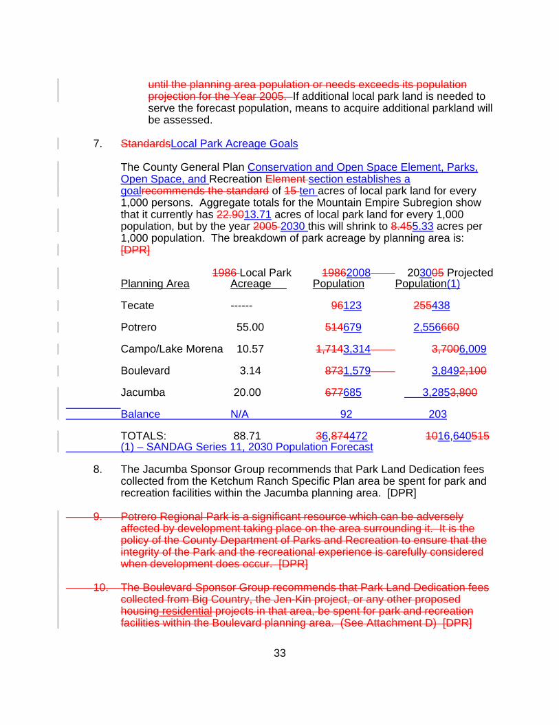
7. StandardsLocal Park Acreage Goals The County General Plan Conservation and Open Space Element, Parks,
Open Space, and Recreation Element section establishes a goalrecommends the standard of 15 ten acres of local park land for every 1,000 persons. Aggregate totals for the Mountain Empire Subregion show that it currently has 22.9013.71 acres of local park land for every 1,000 population, but by the year 2005 2030 this will shrink to 8.455.33 acres per 1,000 population. The breakdown of park acreage by planning area is: [DPR]
1986 Local Park 19862008 203005 Projected Planning Area Acreage Population Population(1) Tecate ------ 96123 255438 Potrero 55.00 514679 2,556660 Campo/Lake Morena 10.57 1,7143,314 3,7006,009 Boulevard 3.14 8731,579 3,8492,100 Jacumba 20.00 677685 3,2853,800 Balance N/A 92 203 TOTALS: 88.71 36,874472 1016,640515 (1) – SANDAG Series 11, 2030 Population Forecast 8. The Jacumba Sponsor Group recommends that Park Land Dedication fees
collected from the Ketchum Ranch Specific Plan area be spent for park and recreation facilities within the Jacumba planning area. [DPR]
9. Potrero Regional Park is a significant resource which can be adversely
affected by development taking place on the area surrounding it. It is the policy of the County Department of Parks and Recreation to ensure that the integrity of the Park and the recreational experience is carefully considered when development does occur. [DPR]
10. The Boulevard Sponsor Group recommends that Park Land Dedication fees
collected from Big Country, the Jen-Kin project, or any other proposed housing residential projects in that area, be spent for park and recreation facilities within the Boulevard planning area. (See Attachment D) [DPR]

34
8. ENERGY GOAL ENSURE THAT THE CONSERVATION OF NON-RENEWAL ENERGY
RESOURCES IS PURSUED IN A WAY THAT IS NOT DETRIMENTAL TO THE RURAL LIFESTYLE.
FINDINGS Site planting and building design can be used to reduce heating and cooling costs
and to provide more comfortable indoor and outdoor living spaces. Advances in technology are producing energy-effective housing designs and
improvements in home energy systems. POLICIES AND RECOMMENDATIONS 1. New development should utilize alternative energy technologies, especially
active and passive solar systems. [GEN] 2. Protected courtyards, porches, arcades, loggias, verandas and overhangs
are effective means of shading exterior wall surfaces and windows from direct sun exposure. These elements are easily added to buildings as temperature-moderating elements. An additional benefit is their ability to add character to the building. [GEN]
3. Deciduous trees used on the south and west sides of a building can provide
shade in summer while allowing sun penetration in winter. [GEN] 4. Roof overhangs on south-facing walls offer effective protection of window
areas from summer sun while admitting lower winter sun rays. [GEN] 5. South-facing courtyards may be used to create protected outdoor spaces,
giving the site a more favorable micro climate for year-round activities. [GEN]
9. SCENIC HIGHWAYS GOAL ESTABLISH A NETWORK OF SCENIC HIGHWAY CORRIDORS WITHIN WHICH
SCENIC, HISTORICAL, AND RECREATIONAL RESOURCES ARE PROTECTED AND ENHANCED.
35
FINDINGS There are seven scenic corridors identified on the Scenic Highways Figure C-5 in
the Conservation and Open Space Element System Plan Map" which that pass through the Mountain Empire Subregional Plan Area:. Four of the corridors are listed as second priority scenic routes in the Scenic Highways Element of the General Plan. These are:
1. Tecate Road, from the Mexican border north to State Route 94; 2. Potrero Valley Road, from State Route 94 to Potrero County Park; 3. Lake Morena Drive from Buckman Springs Road, north to Morena Lake; 4. Oak Drive, from Lake Morena Drive North to Buckman Springs Road. The remaining corridors are listed as third priority scenic routes. These are: 15. Interstate 8, from State Route 79 east to the Imperial County Line; 26. State Route 94, from State Route 125 to Interstate 8; and 37. Buckman Springs Road, from Lake Morena Drive to State Route 94. POLICIES AND RECOMMENDATIONS 1. Mitigate the effects of development located within or in clear view of a
designated scenic corridor. [RPP]

36
APPENDIX A
37
RESOURCE CONSERVATION AREAS This overlay identifies lands requiring special attention in order to conserve resources in a manner best satisfying public and private objectives. The appropriate implementation actions will vary depending upon the conservation objectives of each resource but may include: public acquisition, establishment of open space easements, application of special land use controls such as cluster zoning, large lot zoning, scenic or natural resource preservation overlay zones, or by incorporating special design considerations into subdivision maps or special use permits. Resource conservation areas shall include but are not limited to groundwater problem areas, coastal wetlands, native wildlife habitats, construction quality sand areas, littoral sand areas, astronomical dark sky areas, unique geological formations, and significant archaeological and historical sites. Within Resource Conservation Areas, County departments and other public agencies shall give careful consideration and special environmental analysis to all projects which they intend to carry out, propose, or approve, and shall select those conservation actions most appropriate to the project and consistent with the intent of this overlay designation. The Conservation and Open Space Section (3) of the Community Plan includes a Resource Conservation Element Area Map and reference to Resource Conservation Areas (RCAs) by number. This appendix identifies those areas, and provides discussion of those resources to be conserved in each of the numbered areas. CRITERIA The following criteria were used in selecting resources worthy of conservation: -- Areas necessary for the protection of wildlife and representative stands of native vegetation. -- Areas containing rare and/or endangered plants. -- Wildlife habitats which are: a. in large blocks, if possible; b. wide, rather than long and narrow to minimize adverse effects along their margins; and c. in contact with other wild areas and floodplains to provide migration corridors. -- Areas containing mineral resources. Conservation measures should ensure future availability.
38

39
This page intentionally left blank
40
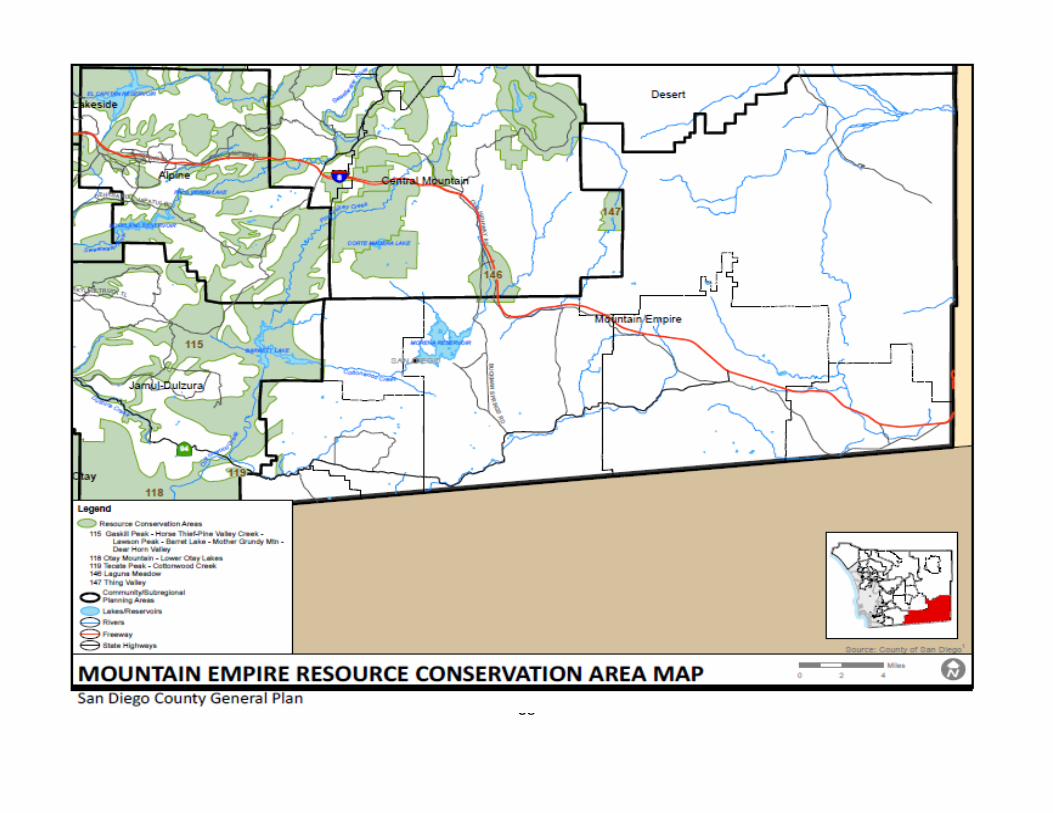
115. Gaskill Peak, Horse Thief-Pine Valley Creek, Lawson Peak, Barrett Lake, Mother Grundy Mountain, Deer Horn Valley Lawson Peak is a scenically important mountain as well as biologically important area because of the presence of the threatened Felt leaf rock mint, Gander's butterweed, and the rare Campo clarkia and Creeping sage. This resource conservation area also contains the Riparian and Oak woodlands of Hollenbeck Canyon, Pringle Canyon, and Dulzura Creek. The rock formation namesake for this mountain is a prominent landscape feature for the Dulzura area. It also contains some of the rare and endangered species that occur in the Barrett RCA. Resources in this area include Tecate Peak as an international landmark, Cottonwood Creek and its waterfall, Riparian woodlands, as well as rare and endangered plants such as Mountain misery, the spectacular Campo pea, Cleveland monkey flower, Dense reed grass, Slender pod caulanthus, Gander's butterweed and Orcutt's brodiaea. 119. Tecate Peak Cottonwood Creek Resources in this area include Tecate Peak as an international landmark, Cottonwood Creek and its waterfall, Riparian woodlands, stands of the rare Tecate cypress, as well as rare and endangered plants such as Mountain misery, the spectacular Campo pea, Cleveland monkey flower, Dense reed grass, Slender pod caulanthus, Gander's butterweed and Orcutt's brodiaea.
41
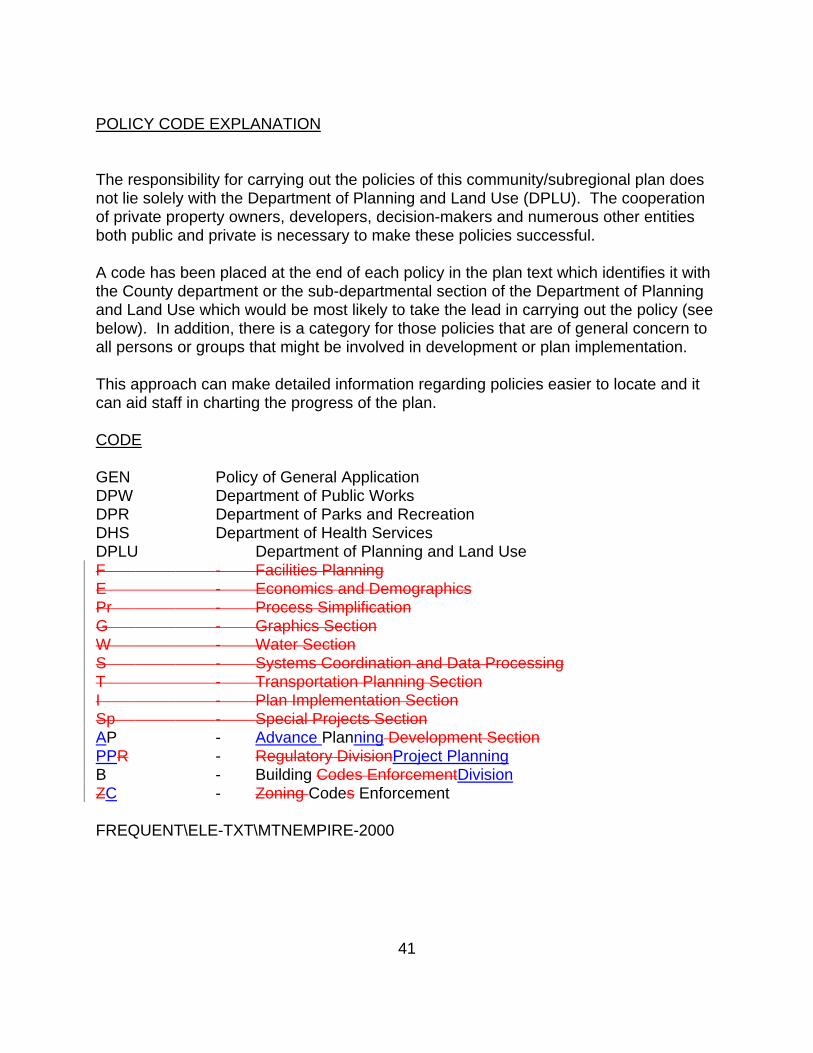
POLICY CODE EXPLANATION The responsibility for carrying out the policies of this community/subregional plan does not lie solely with the Department of Planning and Land Use (DPLU). The cooperation of private property owners, developers, decision-makers and numerous other entities both public and private is necessary to make these policies successful. A code has been placed at the end of each policy in the plan text which identifies it with the County department or the sub-departmental section of the Department of Planning and Land Use which would be most likely to take the lead in carrying out the policy (see below). In addition, there is a category for those policies that are of general concern to all persons or groups that might be involved in development or plan implementation. This approach can make detailed information regarding policies easier to locate and it can aid staff in charting the progress of the plan. CODE GEN Policy of General Application DPW Department of Public Works DPR Department of Parks and Recreation DHS Department of Health Services DPLU Department of Planning and Land Use F - Facilities Planning E - Economics and Demographics Pr - Process Simplification G - Graphics Section W - Water Section S - Systems Coordination and Data Processing T - Transportation Planning Section I - Plan Implementation Section Sp - Special Projects Section AP - Advance Planning Development Section PPR - Regulatory DivisionProject Planning B - Building Codes EnforcementDivision ZC - Zoning Codes Enforcement FREQUENT\ELE-TXT\MTNEMPIRE-2000
Memorandum
To: Devon MutoDepartment of Planning and Land Use, County of San Diego
From: Dave Sorenson, T.E.Adam Dankberg, P.E.Kimley-Horn and Associates, Inc.
Date: May 21, 2009
Subject: Tecate Sponsor Group Proposed Land Use and Traffic Modeling
This technical report summarizes and evaluates the Tecate Sponsor Group’sproposed land plan for the Tecate area of San Diego County. Tecate, USAcurrently has minimal development, but is located directly across theinternational border from Tecate, Mexico, which has a population of 94,000.Tecate, USA is relatively isolated from other more populated communities in SanDiego County, such as Jamul (21 miles), Rancho San Diego (26 miles), andeastern Chula Vista (28 miles). As such, the Tecate Sponsor Group desires todevelop a land use plan focused on interacting with the nearby, heavily populatedTecate, Mexico. The Sponsor Group also seeks to create an economically viableplan that does not overburden the traffic load on State Route 94. A land use planfocused on appealing to Mexican consumers may actually improve State Route94 by attracting shoppers locally that would otherwise travel into San Diego andother shopping areas accessed by State Route 94. The Tecate Sponsor Group hasretained a consultant team to help develop a plan that meets the above objectives,and this team has been in dialogue with County staff to help refine the plan.
Market Demand in Mexico for Tecate, USA Services
One of the first steps in developing the plan was to determine the demand fromMexican residents for services in the USA. Economic Research Associates wasretained to prepare a retail analysis specifically targeting those crossing fromMexico into the United States at the Tecate border crossing. The resulting study,Tecate Retail Analysis II, March 22, 2007, reached the following conclusions:
Suite 600401 B StSan Diego, California92101
TEL 619 234 9411FAX 619 234 9433
Mr. Devon Muto, May 21, 2009, Page 2 of 7
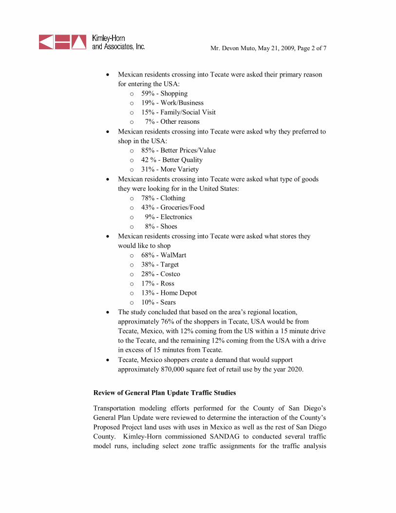
Mexican residents crossing into Tecate were asked their primary reasonfor entering the USA:
o 59% - Shoppingo 19% - Work/Businesso 15% - Family/Social Visito 7% - Other reasons
Mexican residents crossing into Tecate were asked why they preferred toshop in the USA:
o 85% - Better Prices/Valueo 42 % - Better Qualityo 31% - More Variety
Mexican residents crossing into Tecate were asked what type of goodsthey were looking for in the United States:
o 78% - Clothingo 43% - Groceries/Foodo 9% - Electronicso 8% - Shoes
Mexican residents crossing into Tecate were asked what stores theywould like to shop
o 68% - WalMarto 38% - Targeto 28% - Costcoo 17% - Rosso 13% - Home Depoto 10% - Sears
The study concluded that based on the area’s regional location,approximately 76% of the shoppers in Tecate, USA would be fromTecate, Mexico, with 12% coming from the US within a 15 minute driveto the Tecate, and the remaining 12% coming from the USA with a drivein excess of 15 minutes from Tecate.Tecate, Mexico shoppers create a demand that would supportapproximately 870,000 square feet of retail use by the year 2020.
Review of General Plan Update Traffic Studies
Transportation modeling efforts performed for the County of San Diego’sGeneral Plan Update were reviewed to determine the interaction of the County’sProposed Project land uses with uses in Mexico as well as the rest of San DiegoCounty. Kimley-Horn commissioned SANDAG to conducted several trafficmodel runs, including select zone traffic assignments for the traffic analysis
Mr. Devon Muto, May 21, 2009, Page 3 of 7
zones in Tecate, USA and the traffic analysis zone representing vehicles enteringthe United States from Tecate, Mexico. Kimley-Horn reviewed both the Series10 General Plan traffic model and the updated Series 11 traffic model, with theinclusion of General Plan land uses. Based on a review of the modeling data byKimley-Horn, County staff and consultants, and SANDAG staff, the followingconclusions were reached:
The General Plan traffic model dramatically underrepresented the trafficinteraction between Tecate, USA and Mexico.The traffic model matched too much traffic internally amongst the threeTecate, USA Traffic Analysis Zones.Traffic on State Route 94, west of Tecate Road, was shown by theGeneral Plan traffic model to exceed the capacity of that roadway,resulting in projected Level-of-Service F conditions.Traffic projections for the Tecate Sponsor Group plan should bedeveloped based on the findings of this modeling review and theeconomic analysis.
Tecate Sponsor Group Land Use Plan
A land use plan was developed to best respond to retail market demands fromTecate, Mexico, as shown by the economic study. Figure 1 displays the TecateSponsor Group land use plan; however, a Specific Plan will be prepared for thecommunity and the intensity and distribution of land uses will be determinedduring the preparation and adoption of that document. The plan includes certainelements of the Proposed Project land use plan, but with a number ofmodifications. The Sponsor Group plan incorporates a total of just under 100acres of retail use, corresponding to approximately 1 million square feet of actualbuilding area. The retail is focused along Tecate Road to maximize visibility tomotorists traveling up from Mexico. The retail would be located in two areas.The first area would be on both sides of Tecate Road between the border andHumphries Road. The second area would be located north of Humphries Roadon the east side of Tecate Road. This area was intentionally placed on the eastside to facilitate ease of flow into the site (right-turn movements) and designedwith deep parcel sizes that may attract the larger multi-faceted retailers desiredby Mexican shoppers.
The remainder of the plan is similar to the Board Referral Alternative, with theexception that nearly all Medium Impact Industrial was changed to LimitedImpact Industrial, to reflect actual market demands and to reduce trip makingpotential. Limited impact industrial uses include warehousing, storage, and light
Mr. Devon Muto, May 21, 2009, Page 4 of 7
industrial business park. These uses have less environmental impact andgenerate fewer trips than the manufacturing/assembly-associated usesincorporated into the medium impact industrial classification, allowing for anincrease in total acreage, while reducing the total trip generation.
Trip Generation
Trip generation for the plan was calculated using building square footageestimates and detailed selection of appropriate land use types, since many of theuses proposed in the Sponsor Group plan were specifically selected to capturetraffic crossing the border, based on the market research. Trip rates were utilizedfrom the SANDAG Brief Guide of Vehicular Traffic Generation Rates. Modeledtrip rates that are assigned by broad land use classification were deemed to be toogeneral for this effort. Table 1 displays the trip generation estimates for theSponsor Group Plan. This plan generates about 65,000 daily trip ends, of whichseventy-four percent is attributable to retail activity. Residential use occupiesmost of the land, but due to the very low density (1 dwelling unit per 10, 20 or 40acres), only about 90 dwelling units are anticipated to be built. Industrial use islocated on approximately 350 acres and generates about twenty-five percent ofthe trips. See Table 1 for the mix of specific land use types assumed for eachland use designation.
Table 2 compares the land use and trip generation of the Tecate Sponsor GroupPlan to the Proposed Project analyzed in the General Plan Environmental ImpactReport. The Sponsor Group plan generates about two-thirds of the traffic of theProposed Project, largely due to the shift in industrial intensity and by limitinguses to those that would likely interact with Tecate, Mexico.
Trip Interaction
The Tecate Sponsor Group plan was designed such that the majority of trip endsgenerated in Tecate, USA will not be utilizing State Route 94. Figure 2 wasprepared to illustrate the interaction that is expected for retail uses. Forty percentof the retail trips are expected to be made by Mexican shoppers. Another fortypercent of the retail trips are expected to occur between other uses in Tecate,USA. These uses include residential, employment/industrial, and other retailsites (linked shopping trips). Due to the time penalty associated with crossing theinternational border and the lack of competing retail centers anywhere near thearea, it is anticipated that many shoppers to the area will visit multiple retailstores. The remaining twenty percent of the retail trips would use State Route 94.The split of trips between those using SR-94 to/from the east and those using SR-
Mr. Devon Muto, May 21, 2009, Page 5 of 7
94 to/from the west was based on a select zone assignment for Tecate, USA ofthe General Plan Update EIR traffic forecast model.
Figure 3 shows the distribution of industrial trips. Thirty-five percent of theindustrial trips are expected to cross into Tecate, Mexico. It is expected that mostindustrial sites developing in Tecate will have some type of interaction withMexico, due to proximity to the border and isolation from the more populatedportions of San Diego County. Twenty percent of the industrial trips areexpected to interact with Tecate residential (workers) and retail (lunch andservice trips). The remaining forty-five percent of the industrial trips would useState Route 94. The split of trips between those using SR-94 to/from the east andthose using SR-94 to/from the west was based on a select zone assignment forTecate, USA of the General Plan Update EIR traffic forecast model.
Figure 4 shows the distribution of residential trips from Tecate. The overallnumber of residential trips is minor compared with the number of retail andindustrial trips due to the minimal amount of residential development anticipatedto occur in the area. Seventeen percent of the residential trips are expected tocross into Mexico (one round trip per day per dwelling unit). Half of theresidential trips would interact with other uses in Tecate, USA. The remainingone-third of the trips (two round trips out of town per day per dwelling unit)would use State Route 94.
Figure 5 summarizes the combined trip distribution of all proposed uses inTecate, USA. As shown, just less than 25,000 daily trips are expected to interactbetween Tecate, USA and Mexico. This reflects thirty-eight percent of the totaltrip ends in Tecate, USA. About twenty-six percent of the trips will travel onState Route 94 to the east and west. The remainder of the trips will be betweenuses in Tecate, USA.
Table 3, shown below, displays the assumed interaction between Tecate, USAuses. It should be noted that most of the retail internal interaction is to/fromother retail sites in the community. This is logical in that many of the shoppingtrips from Mexico will likely involve stops at multiple stores.
Table 3Internal Trip Interaction between Tecate uses (in daily trip ends)
From/To Retail Industrial ResidentialRetail 15,577 3,127 486
Industrial 3,127 0 54Residential 486 54 0
Mr. Devon Muto, May 21, 2009, Page 6 of 7
Figure 6 shows the resulting daily traffic volumes on roadways within Tecate,including traffic crossing the border and on State Route 94. The amount oftraffic from Mexico shown traveling on State Route 94 is approximately the sameas existing conditions, which is a conservative approach since many existingshopping trips from Mexico would no longer need to use State Route 94. Figure7 depicts the traffic volumes assigned to County Circulation Element roadwaysin the areas influenced by Tecate traffic patterns. As shown in Figure 7, allroadways operate at acceptable LOS D or better conditions. Per the CountyGeneral Plan Update Environmental Impact Report traffic forecast model, SR-94is classified as a two-lane Community Collector with Improvement Optionsthroughout the study area with a total of capacity of 19,000 daily trips. As notedon this figure, Tecate Road will require further analysis to determine the roadwaywidth, which will depend on the spatial distribution of specific land uses withinTecate. Given the existing level of detail in the analysis, it is recommended thatTecate Road be a four lane Major Street, and the right-of-way width required bya six-lane Prime Arterial be reserved to allow for expansion should future studiesindicate the need for additional capacity.
Additional Land Use Plan Considerations
While the land use plan shown in Figure 1 meets a number of stakeholderobjectives, it is likely that future site development patterns will result inmodifications to the precise placement of specific land uses and parcel accesspoints. In order to ensure that any revisions to the land use plan do notsubstantially alter the conclusion of this report that SR-94 would operateeffectively with Sponsor Group plan, the daily trip generation for the areacovered by the plan should be limited to 65,000 total trips. Refinement of theland use plan may require modifications to the proposed internal Tecatetransportation network, including Tecate Road and associated collectors.
Additional site design and transportation elements should be encouraged as theland use plan comes to fruition. Encouragement of the development of shuttle,pedestrian and bicycle facilities near the border will further encourage trips fromMexico to remain in Tecate and utilize the planned commercial uses in the area.In addition, with the projected increase in cross-border interaction with Mexico,demands on border-crossing inspection facilities will increase, resulting inpotential impact. The Sponsor Group plan provides additional parcels for federalinspection facilities beyond those identified in the Proposed Project. The extentto which existing inspection facilities will require expansion will need to beconsidered by federal agencies.
SR-94 currently has truck use restrictions due to the rural character of theroadway. Between SR-125 and Otay Lakes Road, it is classified as a Terminal

Mr. Devon Muto, May 21, 2009, Page 7 of 7
Access Route, allowing use by all California Legal Trucks. Between Otay LakesRoad and Tierra del Sol Road (located two miles west of the junction with I-8),SR-94 is classified as a California Legal Advisory Route. Over this stretch of 38miles of SR-94, a Truck Advisory is in effect. Over this stretch, trucks with akingpin-to-rear-axle length of 30 feet or greater are not advised. Between Tierradel Sol Road and I-8, SR-94 is classified as a Terminal Access Route. SR-188(Tecate Road) has a similar Truck Advisory as SR-94 between SR-94 andHumphries Road. Between Humphries Road and the border it is classified as aCalifornia Legal Route, allowing use by all California Legal Trucks. It isanticipated that future development in the Tecate area will need to abide by theseadvisories.
Summary
The above analysis indicates that, given a land use plan focused on attractingMexican consumers and minimizing traffic to/from other portions of San DiegoCounty, development can occur in Tecate while maintaining State Route 94 as atwo-lane roadway. The land use plan developed and contained in thismemorandum leans on the economic analysis performed of border crossers atTecate, which indicates strong Mexican demand for American retail uses near theborder crossing. Given the remoteness of Tecate, USA to other populated areason the American side of the border, it is anticipated that the trips generated by theproposed land uses will be primarily linked within the Tecate, Mexico andTecate, USA area, minimizing trips on State Route 94.
Attachments:Figure 1: General Plan Update – Tecate Sponsor Group Land Use PlanFigure 2: Tecate, USA Retail Trip Distribution with Sponsor Group Proposed
Land UseFigure 3: Tecate, USA Industrial Trip Distribution with Sponsor Group Proposed
Land UseFigure 4: Tecate, USA Residential Trip Distribution with Sponsor Group
Proposed Land UseFigure 5: Tecate, USA Total Trip Distribution with Sponsor Group Proposed
Land UseFigure 6: Daily Roadway Volumes with Sponsor Group Land UseFigure 7: 2030 Level of Service and Daily Volumes with Sponsor Group Land
UseTable 1: Proposed Tecate Land Uses Trip Generation SummaryTable 2: Tecate Land Use ComparisonK:\TPTO\095591000\Word\Tecate Land Use Report 1-20-09.docx
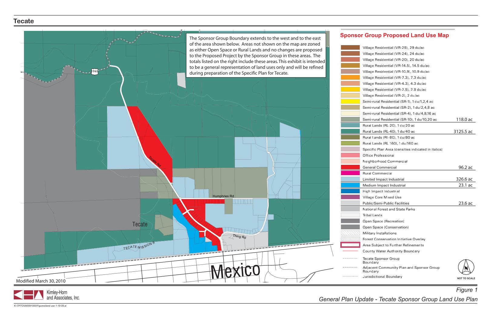
NOT TO SCALE
K:\TPTO\095591000\Figures\land use 1-19-09.ai
Figure 1General Plan Update - Tecate Sponsor Group Land Use Plan
Tecate
County of San Diego
Tecate Rd
Thing Rd
Humphries Rd
County of San Diego
Tecate Rd
Thing Rd
Humphries Rd
Sponsor Group Proposed Land Use Map
96.2 ac
326.6 ac23.1 ac
23.6 ac
118.0 ac
3125.5 ac
The Sponsor Group Boundary extends to the west and to the eastof the area shown below. Areas not shown on the map are zonedas either Open Space or Rural Lands and no changes are proposedto the Proposed Project by the Sponsor Group in these areas. Thetotals listed on the right include these areas. This exhibit is intendedto be a general representation of land uses only and will be refinedduring preparation of the Specific Plan for Tecate.
Modified March 30, 2010
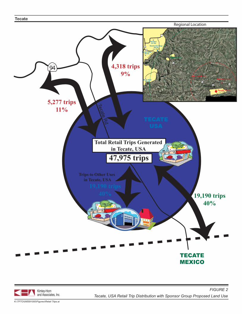
NOT TO SCALE
Tecate
FIGURE 2Tecate, USA Retail Trip Distribution with Sponsor Group Proposed Land Use
K:\TPTO\095591000\Figures\Retail Trips.ai
94CALIFORNIA
TECATEMEXICO
TECATEUSA
Tecate Rd
19,190 trips40%
Trips to Other Uses in Tecate, USA
5,277 trips11%
4,318 trips9%
19,190 trips40%
Otay Lakes Rd
Jamac
ha Blvd
94CALIFORNIA
INTERSTATE
CALIFORNIA
8
125CALIFORNIA
94CALIFORNIA
94CALIFORNIA
94CALIFORNIA
188TecateTecate (1 mi)
Jamul (21 mi)
Dulzura (10 mi)
Rancho San Diego(26 mi)
Spring Valley(30 mi)
Chula Vista(28 mi)
El Cajon(31 mi)
Potrero (5 mi)
Mexico
USA pop 94,000
pop 150
pop 700
pop 6,000
pop 20,100
pop 900
Regional Location
Total Retail Trips Generatedin Tecate, USA
47,975 trips
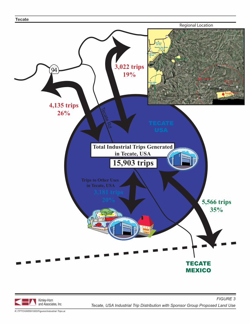
NOT TO SCALE
Tecate
FIGURE 3Tecate, USA Industrial Trip Distribution with Sponsor Group Proposed Land Use
K:\TPTO\095591000\Figures\Industrial Trips.ai
94CALIFORNIA
TECATEMEXICO
TECATEUSA
Tecate Rd
3,181 trips20%
Trips to Other Uses in Tecate, USA
4,135 trips26%
3,022 trips19%
5,566 trips35%
Otay Lakes Rd
Jamac
ha Blvd
94CALIFORNIA
INTERSTATE
CALIFORNIA
8
125CALIFORNIA
94CALIFORNIA
94CALIFORNIA
94CALIFORNIA
188TecateTecate (1 mi)
Jamul (21 mi)
Dulzura (10 mi)
Rancho San Diego(26 mi)
Spring Valley(30 mi)
Chula Vista(28 mi)
El Cajon(31 mi)
Potrero (5 mi)
Mexico
USA pop 94,000
pop 150
pop 700
pop 6,000
pop 20,100
pop 900
Regional Location
Total Industrial Trips Generatedin Tecate, USA
15,903 trips
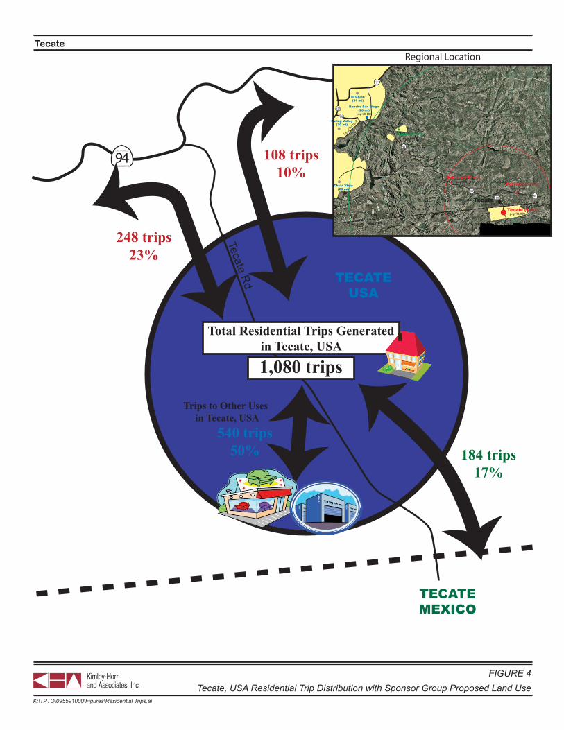
NOT TO SCALE
Tecate
FIGURE 4Tecate, USA Residential Trip Distribution with Sponsor Group Proposed Land Use
K:\TPTO\095591000\Figures\Residential Trips.ai
94CALIFORNIA
TECATEMEXICO
TECATEUSA
Tecate Rd
540 trips50%
Trips to Other Uses in Tecate, USA
248 trips23%
108 trips10%
184 trips17%
Otay Lakes Rd
Jamac
ha Blvd
94CALIFORNIA
INTERSTATE
CALIFORNIA
8
125CALIFORNIA
94CALIFORNIA
94CALIFORNIA
94CALIFORNIA
188TecateTecate (1 mi)
Jamul (21 mi)
Dulzura (10 mi)
Rancho San Diego(26 mi)
Spring Valley(30 mi)
Chula Vista(28 mi)
El Cajon(31 mi)
Potrero (5 mi)
Mexico
USA pop 94,000
pop 150
pop 700
pop 6,000
pop 20,100
pop 900
Regional Location
Total Residential Trips Generatedin Tecate, USA
1,080 trips
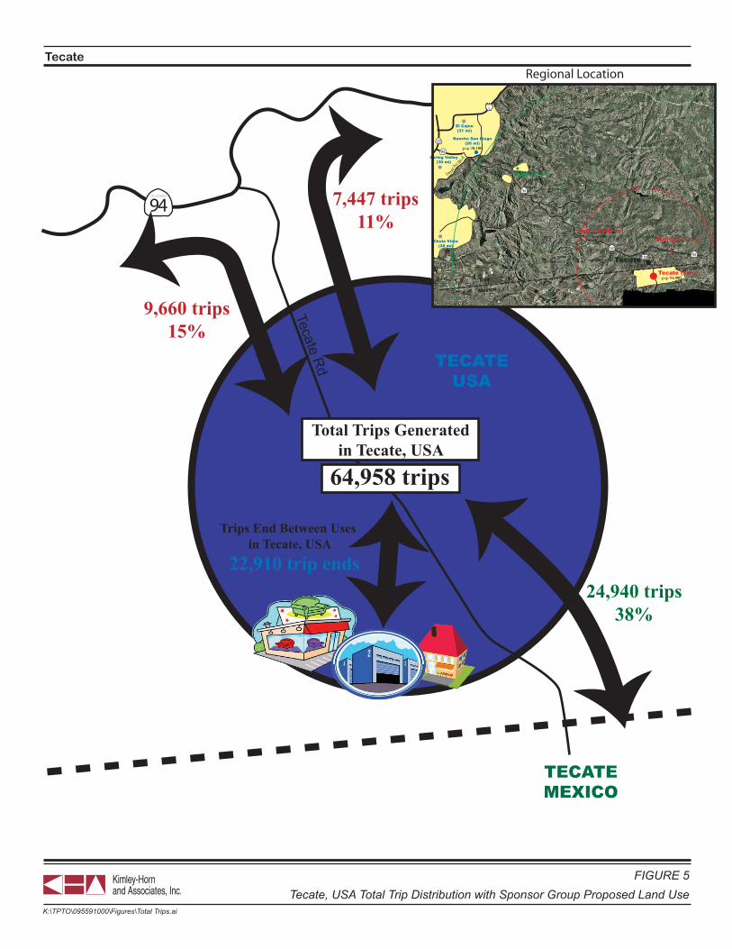
NOT TO SCALE
Tecate
FIGURE 5Tecate, USA Total Trip Distribution with Sponsor Group Proposed Land Use
K:\TPTO\095591000\Figures\Total Trips.ai
94CALIFORNIA
TECATEMEXICO
TECATEUSA
Tecate Rd
22,910 trip ends
Trips End Between Uses in Tecate, USA
9,660 trips15%
7,447 trips11%
24,940 trips38%
Otay Lakes Rd
Jamac
ha Blvd
94CALIFORNIA
INTERSTATE
CALIFORNIA
8
125CALIFORNIA
94CALIFORNIA
94CALIFORNIA
94CALIFORNIA
188TecateTecate (1 mi)
Jamul (21 mi)
Dulzura (10 mi)
Rancho San Diego(26 mi)
Spring Valley(30 mi)
Chula Vista(28 mi)
El Cajon(31 mi)
Potrero (5 mi)
Mexico
USA pop 94,000
pop 150
pop 700
pop 6,000
pop 20,100
pop 900
Regional Location
Total Trips Generatedin Tecate, USA
64,958 trips

NOT TO SCALE
Tecate
FIGURE 6Daily Roadway Volumes with Sponsor Group Land Use
K:\TPTO\095591000\Figures\Tecate Roadway Vols.ai
94CALIFORNIA
TECATEMEXICO
TECATEUSA
Tecate Rd
Total Volume: 23,108To/From Tecate, USA: 17,108
To/From Tecate, Mexico: 6,000
Total Volume: 30,940To/From Tecate, USA: 24,940
To/From SR-94: 6,000
Total Volume: 15,194To/From Tecate, USA: 9,660
To/From Tecate, Mexico: 5,004To/From SR-94 E/O Tecate Rd: 530
Total Volume: 8,973To/From Tecate, USA: 7,447To/From Tecate, Mexico: 996
To/From SR-94 W/O Tecate Rd: 530
Note: Volumes are daily and bi-directional
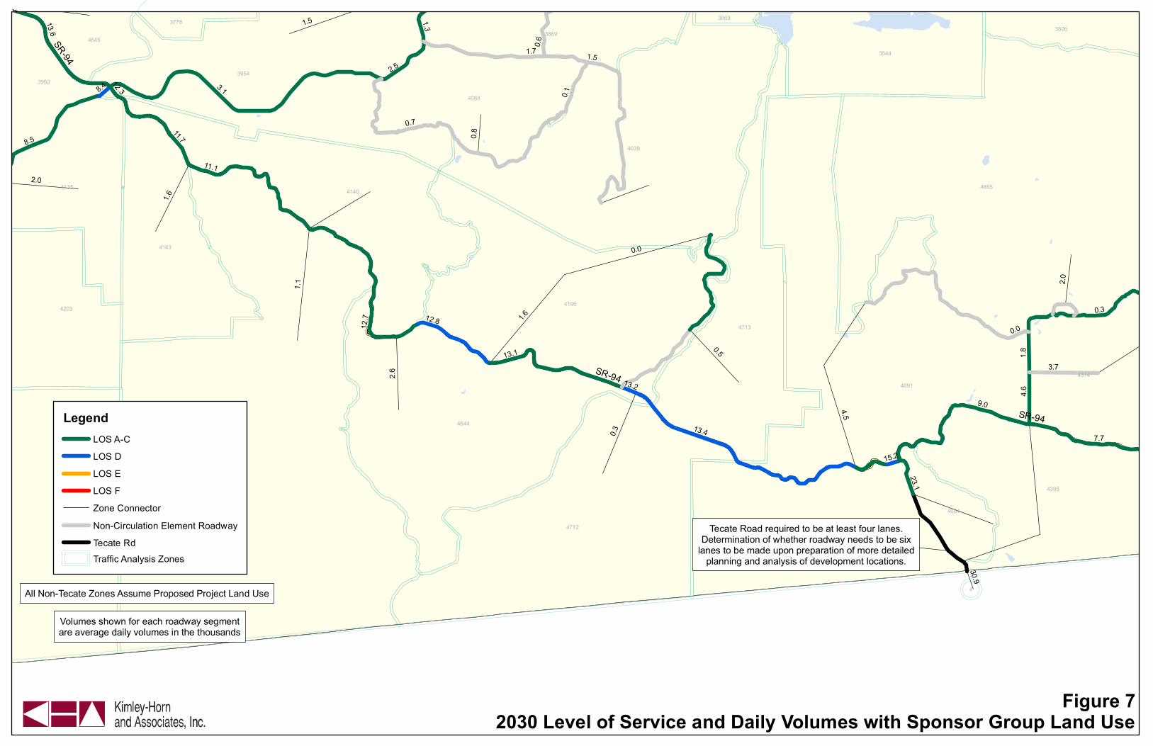
4192
4665
4091
4039
4712
4644
4196
3954
43854388
4140
4713
4395
4143
3544
4088
4203
4135
4314
3869
3962
4664
3506
4645
3778
4
3869
SR-94
SR-94
SR-94
3.1
0.0
1.1
13.4
1.5
0.1
9.0
1.7
0.7
0.5
1.6
3.7
7.7
8.5
4.5
11.1
12.7
13.1
0.3
13.6
1.8
2.6
11.7
12.8
2.0
2.5
4.6
0.6
0.8
15.2
1.3
23.1
8.4
30.9
13.2
12.3
2.0
1.5
1.6
0.3
0.0
Figure 72030 Level of Service and Daily Volumes with Sponsor Group Land Use
LegendLOS A-C
LOS D
LOS E
LOS F
Zone Connector
Non-Circulation Element Roadway
Tecate Rd
Traffic Analysis Zones
Volumes shown for each roadway segmentare average daily volumes in the thousands
All Non-Tecate Zones Assume Proposed Project Land Use
Tecate Road required to be at least four lanes.Determination of whether roadway needs to be six
lanes to be made upon preparation of more detailedplanning and analysis of development locations.
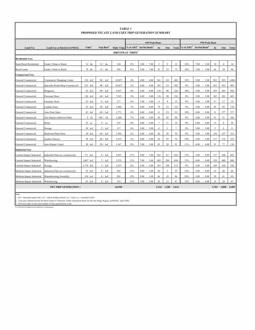
AM Peak-Hour PM Peak-Hour
Land Use Land Use as listed in SANDAG Units1 Trip Rate2 Daily Trips % of ADT2 In:Out Ratio2 In Out Total % of ADT2 In:Out Ratio2 In Out Total
DRIVEWAY TRIPS3
Residential Uses
Semi-Rural Residential Estate, Urban or Rural 12 du 12 / du 144 8% 3.00 : 7.00 3 9 12 10% 7.00 : 3.00 10 4 14
Rural Lands Estate, Urban or Rural 78 du 12 / du 936 8% 3.00 : 7.00 22 53 75 10% 7.00 : 3.00 66 28 94
Commercial Uses
General Commercial Community Shopping Center 126 ksf 80 / ksf 10,057 4% 6.00 : 4.00 241 161 402 10% 5.00 : 5.00 503 503 1,006
General Commercial Specialty Retail/Strip Commercial 251 ksf 40 / ksf 10,057 3% 6.00 : 4.00 181 121 302 9% 5.00 : 5.00 453 452 905
General Commercial Drugstore 63 ksf 90 / ksf 5,657 4% 6.00 : 4.00 136 90 226 10% 5.00 : 5.00 283 283 566
General Commercial Discount Store 126 ksf 60 / ksf 7,543 3% 6.00 : 4.00 136 90 226 8% 5.00 : 5.00 302 301 603
General Commercial Furniture Store 63 ksf 6 / ksf 377 4% 7.00 : 3.00 11 4 15 9% 5.00 : 5.00 17 17 34
General Commercial Lumber Store 63 ksf 30 / ksf 1,886 7% 6.00 : 4.00 79 53 132 9% 5.00 : 5.00 85 85 170
General Commercial Auto Parts Sales 63 ksf 60 / ksf 3,771 4% 0.00 : 0.00 0 151 151 10% 0.00 : 0.00 0 377 377
General Commercial Gas Station with/Food Mart 8 vfs 160 / vfs 1,280 7% 5.00 : 5.00 45 45 90 8% 5.00 : 5.00 51 51 102
General Commercial Motel 25 oc 9 / oc 225 8% 4.00 : 6.00 7 11 18 9% 6.00 : 4.00 12 8 20
General Commercial Storage 58 ksf 2 / ksf 117 6% 5.00 : 5.00 4 3 7 9% 5.00 : 5.00 5 6 11
General Commercial Hardware/Paint Store 58 ksf 60 / ksf 3,502 2% 6.00 : 4.00 42 28 70 9% 5.00 : 5.00 158 157 315
General Commercial Garden Nursery 58 ksf 40 / ksf 2,335 3% 6.00 : 4.00 42 28 70 10% 5.00 : 5.00 117 116 233
General Commercial Auto Repair Center 58 ksf 20 / ksf 1,167 8% 7.00 : 3.00 65 28 93 11% 4.00 : 6.00 51 77 128
Industrial Uses
Limited Impact Industrial Industrial Park (no commercial) 711 ksf 8 / ksf 5,691 11% 9.00 : 1.00 563 63 626 12% 2.00 : 8.00 137 546 683
Limited Impact Industrial Warehousing 1,067 ksf 5 / ksf 5,335 13% 7.00 : 3.00 485 209 694 15% 4.00 : 6.00 320 480 800
Limited Impact Industrial Storage 1,778 ksf 2 / ksf 3,557 6% 5.00 : 5.00 107 106 213 9% 5.00 : 5.00 160 160 320
Medium Impact Industrial Industrial Park (no commercial) 63 ksf 8 / ksf 503 11% 9.00 : 1.00 50 5 55 12% 2.00 : 8.00 12 48 60
Medium Impact Industrial Manufacturing/Assembly 126 ksf 4 / ksf 503 19% 9.00 : 1.00 86 10 96 20% 2.00 : 8.00 20 81 101
Medium Impact Industrial Warehousing 63 ksf 5 / ksf 314 13% 7.00 : 3.00 29 12 41 15% 4.00 : 6.00 19 28 47
64,958 2,334 1,280 3,614 2,781 3,808 6,589
Note:1. ksf = thousand square feet; vsf = vehicle fueling stations; ac = acres; oc = occupied rooms2. Trip rates referenced from the Brief Guide of Vehicular Traffic Generation Rates for the San Diego Region, SANDAG, April 20023. Driveway trips are the total number of trips generated by a site.K:\TPTO\095591000\Excel\[591000TG01.xlsx]Summary
NET TRIP GENERATION =
PROPOSED TECATE LAND USES TRIP GENERATION SUMMARYTABLE 1

Sponsor GroupProposal
Proposed ProjectAlternative
Semi-rural Residential (SR-10) 118.3 118.3Rural Lands (RL-40) 3125.5 3220.7Total Residential 3243.8 3339.0
General Commercial 96.2 63.8Rural Commercial 4.1Streetfront Commercial 3.8Other Commercial 1.2Total Commercial 96.2 72.9
Church 14.3
Limited Impact Industrial 326.6 17.4Medium Impact Industrial 23.1 255.4Warehousing/Storage 16.1Total Industrial 349.7 288.9
Sponsor Group Proposed ProjectDaily Total Trip Generation 64,958 93,339
K:\TPTO\095591000\Excel\[Model Trip Gen.xlsx]Comparison
Land Use by Alternative (ac)
TECATE LAND USE COMPARISON
Note: Daily trip generation for Proposed Project alternative from SANDAG series 10 GPU model run.Daily trip generation for Sponsor Group land use from projected land uses, floor-to-area ratios, andcorresponding SANDAG daily trip generation rates.
TABLE 2
Land Use