part i. slope & gravity figure 1. gravity. figure 2...
TRANSCRIPT

Geol 108 Lab #6 Landslides and Mass Wasting Week of October 8-12, 2012 PART I. SLOPE & GRAVITY
The main force responsible for mass wasting is gravity. Gravity is the force that acts everywhere on the Earth's surface, pulling everything in a direction toward the center of the Earth. On a flat surface the force of gravity acts downward. So long as the material remains on the flat surface it will not move under the force of gravity.
D = G sin θ N = G cos θ R = resisting force R = µ N (where µ is the frictional coefficient) If D > R, there will be movement. Down-slope movement is favored by steeper slope angles and anything that reduces the
shear strength, such as lowering cohesion among particles or lowering the frictional resistance.
Figure 1. Gravity.
Figure 2. Components of forces acting on a slope.
1 of 8

Figure 3a, 3b, 3c. Role of water and the angle of repose.
PART II. THE ROLE OF WATER The Role of Water Although water is not always directly involved as the transporting medium in mass-wasting processes, it does play an important role. Water increases mass, hence, increasing gravitational attraction. Dry unconsolidated grains will form a pile with a slope angle determined by the angle of repose. The angle of repose is the steepest angle at which a pile of unconsolidated grains remains stable, and is controlled by the frictional contact between the grains. In general, for dry materials the angle of repose increases with increasing grain size, but usually lies between about 30° and 37° .
Slightly wet unconsolidated materials exhibit a very high angle of repose because surface tension between the water and the solid grains tends to hold the grains in place. When the material becomes saturated with water, the angle of repose is reduced to very
small values and the material tends to flow like a fluid. This is because the water gets between the grains and eliminates grain to grain frictional contact. Another aspect of water that affects slope stability is fluid pressure. Fluid pressure counteracts normal stresses, so in the presence of fluid pressure, some of the weight of the overlying rock mass is supported. This is called “effective stress” which is equal to normal stress minus the fluid pressure. When this occurs, friction is reduced, and shear stresses may be large enough to result in slope failure. Shear stresses are unaffected by fluid pressure.
2 of 8

PART III. EXPERIMENTS
Exp. 1. Dry sand and dry gravel
A. The first experiment should be familiar to you since you probably did something similar at the beach at some point in your life. Use the dry sand and build a sand hill. Then use the dry angular gravel to build a hill. Measure the angle of repose for each, and record below. See next page for hints on how to measure. Angle of repose for dry sand = _____________ Angle of repose for dry angular gravel = _____________ B. Which of the descriptions in Figure 4b corresponds with the dry angular gravel?
Figure 4. A. Angle of repose, expressed as degrees. B. Slope, expressed as percent grade. From: Environmental Geology Laboratory, T. Freeman, 2004.
3 of 8
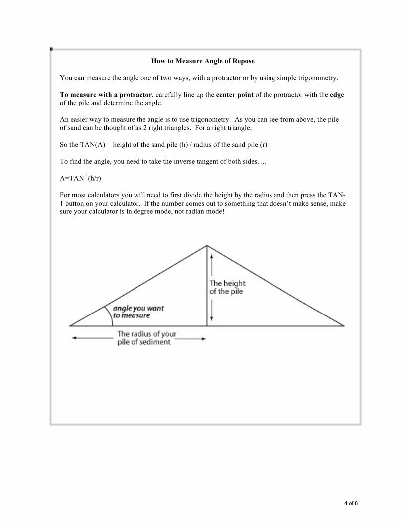
How to Measure Angle of Repose
You can measure the angle one of two ways, with a protractor or by using simple trigonometry. To measure with a protractor, carefully line up the center point of the protractor with the edge of the pile and determine the angle. An easier way to measure the angle is to use trigonometry. As you can see from above, the pile of sand can be thought of as 2 right triangles. For a right triangle, So the TAN(A) = height of the sand pile (h) / radius of the sand pile (r) To find the angle, you need to take the inverse tangent of both sides…. A=TAN-1(h/r) For most calculators you will need to first divide the height by the radius and then press the TAN-1 button on your calculator. If the number comes out to something that doesn’t make sense, make sure your calculator is in degree mode, not radian mode!
4 of 8

Exp. 2. Rain and sediment The following experiment will be done with the help of your TA. The set-up is simple. One layer (wood board) is inclined at a steep angle and overlain by a second layer of unconsolidated, wet material. The slope is oversteepened by construction and removal of material near the bottom (for example road construction). Now heavy rainfall will add water (=weight) to the slope. Observe what happens and describe briefly. Exp. 3. Flash Flood Once the slope started to fail, we now simulate a flash flood. Watch what happens. Briefly describe your observations. What is the feature at the bottom of the slope called?
5 of 8

PART IV. CALIFORNIA HAZARDS 1
DEBRIS FLOW HAZARDS AND THE FIRES OF OCTOBER 2003, SAN BERNARDINO MTS. 1. Maps 1A, 2A, and 3A indicate the probability of fire-related debris flows. What conclusion (one sentence) can you draw after comparing these three maps? 2. Maps 1B, 2B, and 3B indicate the estimated peak discharge of fire-related debris flows. What conclusion (one sentence) can you draw after comparing these three maps? 3. Find Borea Canyon (north of the city of San Bernardino). Look at this canyon on all three maps, 1A, 2A, and 3A. You will notice it is the only area on all three maps to show a high probability of a debris flow occurrence (note red color) under the various amounts of rainfall. Why is this – give your hypothesis. 4. On Dec. 25, 2003, Waterman Canyon was inundated by a mud flow. Compare the rainfall amounts from November 2002 (note circled areas on poster) to the rainfall amounts from Dec. 2003. If the Nov. 2002 amounts were higher, why where there no associated major mud flows? i.e., what made the Dec. 2003 conditions prime for the disaster that occurred at Waterman Canyon?
6 of 8

CALIFORNIA HAZARDS 2
LANDSLIDES - PT. FERMIN, PALOS VERDES, CA Figure 1 is an oblique air photo of a landslide at Point Fermin. The involved area is about 10 acres. Movement was first detected in January 1929, and has been intermittently active ever since. 1. What type of landslide is this? Let's examine the "underlying" causes of this type of land movement. Figure 2 illustrates the basic geologic setting for Point Fermin, and shows sedimentary layers affected by the landslide. View is towards the northwest. Figure 2 is located off to the left margin of Figure 1. 2. What geologic factors might have contributed to the formation of this landslide? (hint - study Figure 2) 3. Are the current residents of this neighborhood in danger of losing their homes at sometime in the future. Explain your reasoning. References: The Lab Book: Problem Solving in Geology, second edition, by Judson, et al., 2000. http://seis.natsci.csulb.edu/VIRTUAL_FIELD/Palos_Verdes/pvmain.htm
7 of 8

PART V. CATASTROPHIC BLOCK GLIDE DOWNTOWN, HOT SPRINGS, ARKANSAS
According to local geologists, four conditions promoted the collapse of a wall of rock in downtown Hot Springs, Arkansas, in November of 1995. Three of the conditions are natural, while a fourth was the undercutting of the slope by shop owners to create more space behind their stores. Undercutting did not produce the failure immediately, but when the three natural conditions coincided, the undercutting tipped the proverbial scale. Sketch looking southward behind shops on the west side of Central Avenue in Hot Springs, Arkansas. Layers of Arkansas Novaculite are inclined parallel to slope.
Reference: Environmental Geology Laboratory, by Tom Freeman, 2004. Identify the three natural conditions and list here:
8 of 8