part a: regional strategic planning · ii part a: regional strategic planning kimberley regional...
TRANSCRIPT
December 2015
Regional Planning and InfrastructureFramework
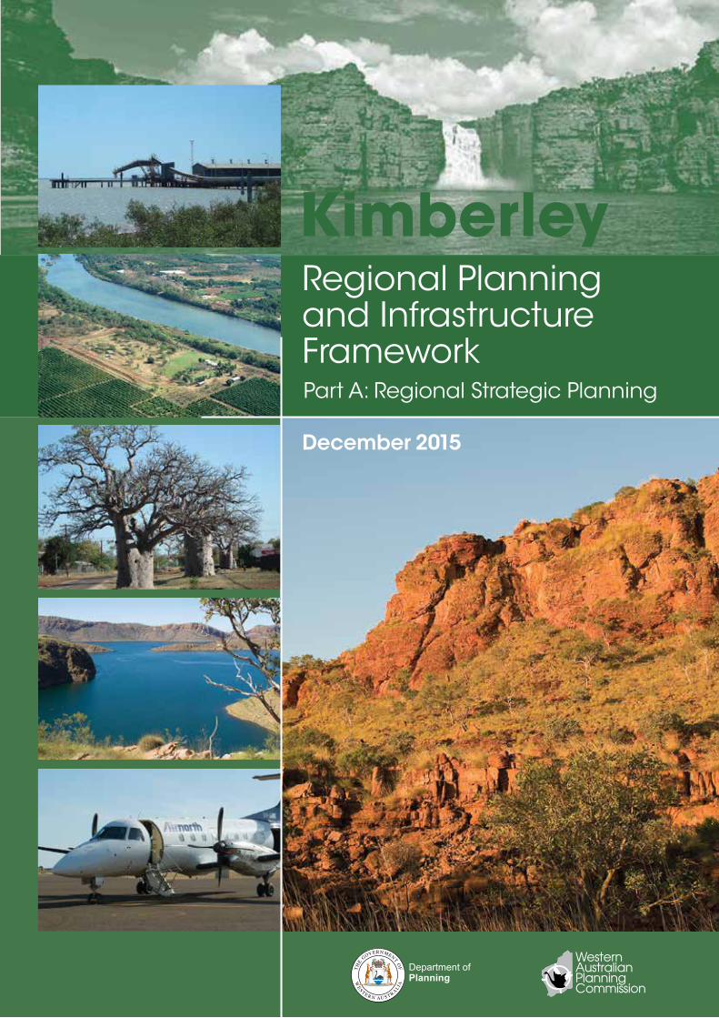
Kimberley
Kim
berley
Part A: Regional Strategic Planning
Regiona
l Planning
and
Infrastructure Fra
mew
ork Part A
Decem
ber 2015
A3 map insertRegional Planning andInfrastructure Framework
Kimberley
December 2015
Part A: Regional Strategic Planning
ii Part A: Regional Strategic Planning
KimberleyRegional Planning and Infrastructure Framework
Disclaimer This document has been published by the Department of Planning on behalf of the Western Australian Planning Commission. Any representation, statement, opinion or advice expressed or implied in this publication is made in good faith and on the basis that the government, its employees and agents are not liable for any damage or loss whatsoever which may occur as a result of action taken or not taken, as the case may be, in respect of any representation, statement, opinion or advice referred to herein. Professional advice should be obtained before applying the information contained in this document to particular circumstances.
The infrastructure projects identified in the Kimberley Regional Planning and Infrastructure Framework are based on existing unaudited information available from State agencies, utilities and departments. The infrastructure listed is not comprehensive and estimates of infrastructure, timeframes and costs are indicative only. Infrastructure identified is based upon the information available at the time of enquiry, and may be subject to review and change to meet new circumstances. Infrastructure identified in the Kimberley Regional Planning and Infrastructure Framework should not be taken as a commitment by Government to fund these projects. Unless otherwise indicated, public funding of projects is not confirmed.
© Western Australian Planning Commission
Published by theWestern Australian Planning Commission140 William StreetPerth WA 6000
Locked Bag 2506Perth WA 6001
Published December 2015
internet: www.planning.wa.gov.auemail: [email protected]
tel: 08 655 19000fax: 08 655 19001National Relay Service: 13 36 77infoline: 1800 626 477
The Department of Planning owns all photography in this document unless otherwise stated. This document is available in alternative formats on application to Communication Services.
iiiPart A: Regional Strategic Planning
KimberleyRegional Planning and Infrastructure Framework
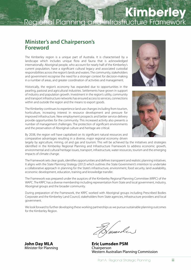
Minister’s and Chairperson’sForewordThe Kimberley region is a unique part of Australia. It is characterised by a landscape which includes unique flora and fauna that is acknowledged internationally. Aboriginal people, who account for nearly half of the Kimberley’s current population, have a significant cultural legacy and associated custodial responsibilities across the region’s lands and waters. The community, stakeholders and government recognise the need for a stronger context for decision-making in a number of areas, and greater coordination of activities and management.
Historically, the region’s economy has expanded due to opportunities in the pearling, pastoral and agricultural industries. Settlements have grown in support of industry and population growth. Investment in the region’s utility, community and transport infrastructure networks has ensured access to services, connections within and outside the region and the means to export goods.
The Kimberley continues to experience land use changes including from tourism, horticulture, increasing interest in resource development and pressure for improved infrastructure. New employment prospects and better service delivery provide opportunities for the community. This increased activity also presents a number of management challenges. The protection of significant environments and the preservation of Aboriginal culture and heritage are critical.
By 2038, the region will have capitalised on its significant natural resources and comparative advantages resulting in a diverse, major regional economy driven largely by agriculture, mining, oil and gas and tourism. This will be achieved by the initiatives and strategies identified in the Kimberley Regional Planning and Infrastructure Framework to address economic growth, environmental and cultural heritage issues, transport, infrastructure, water resources, tourism and the emerging impacts of climate change.
The Framework sets clear goals, identifies opportunities and defines transparent and realistic planning initiatives. It aligns with the State Planning Strategy (2012) which outlines the State Government’s intention to undertake a collaborative approach in planning for the State’s infrastructure, environment, food security, land availability, economic development, education, training and knowledge transfer.
The Framework was prepared under the auspices of the Kimberley Regional Planning Committee (KRPC) of the WAPC. The KRPC has a diverse membership including representation from State and local government, industry, Aboriginal groups and the broader community.
During preparation of the Framework, the KRPC worked with Aboriginal groups including Prescribed Bodies Corporate and the Kimberley Land Council, stakeholders from State agencies, infrastructure providers and local government.
We look forward to further developing these working partnerships as we pursue sustainable planning outcomes for the Kimberley Region.
John Day MLAMinister for Planning
Eric Lumsden PSMChairpersonWestern Australian Planning Commission
Draft

iv Part A: Regional Strategic Planning
KimberleyRegional Planning and Infrastructure Framework
KimberleyRegional Planning and Infrastructure Framework
vPart A: Regional Strategic Planning
Executive summary
Introduction
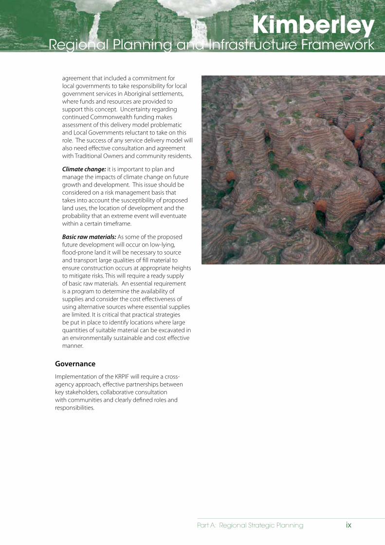
The Kimberley is a unique region that is characterised by its physical landscape that consists of tropical savannahs, spinifex country and coastal islands, significant coastal areas, flood plains and mud flats, diverse waterways and ancient landforms. The biodiversity values of the region, which includes unique flora and fauna, is acknowledged internationally. The Aboriginal people account for nearly half of the Kimberley’s current population and have a significant cultural legacy and associated custodial responsibilities.
Historically, the region’s economy has expanded due to opportunities in the pearling, pastoral and agricultural industries. Settlements have grown in support of industry and population growth while investment in the region’s utility, community service and transport infrastructure networks has ensured access to services, connections within and outside the region, and the means to export goods.
Recently, the Kimberley has experienced a range of land use pressures due to new prospects in the agricultural and horticultural sectors; heightened interest in the development of the region’s mineral and energy resources; and greater understanding of the potential for expanding the tourism industry. These new opportunities will provide significant impetus for economic and population growth driven by enhanced employment prospects and opportunities to improve utility, community and transport infrastructure.
Supporting and fostering growth will continue to present significant management challenges across the region in the future. While there is a strong argument for encouraging and facilitating growth there is also a need to ensure the region’s comparative advantages, including the unique natural environment and cultural history, are not diminished. It is essential that management of the region’s resources be fully inclusive of the region’s Aboriginal people through the provision of opportunities to become more involved in all levels of planning, research and wider promotion and appreciation of their cultural and historical legacy.
Vision
The Kimberley aspires to a long term future transformed into one of the world’s most successful and sustainable region’s. The hallmarks of the success will be:
People – a well-housed, highly educated and healthy people enjoying high amenity in sustainable communities
Place – a place with outstanding infrastructure, services and governance set within a well-conserved and iconic natural environment
Prosperity – shared prosperity arising from the success of the region’s main drivers of economic opportunity: agriculture, Rangeland industries, tourism, minerals and energy.
Purpose
The Kimberley Regional Planning and Infrastructure Framework (KRPIF) defines a strategic direction for the future development of the region over the next 25 years. The KRPIF has been developed in response to the desire by the community, stakeholders and government (at all levels) for a stronger decision-making context across the region, particularly the need for greater coordination of activities and management relating to existing and emerging land use patterns. The Framework identifies a range of strategic initiatives to help achieve comprehensive regional planning whilst having due regard to the region’s natural environment, heritage and culture.
KimberleyRegional Planning and Infrastructure Framework
vi Part A: Regional Strategic Planning
Part A gives context to the scale and distribution of future population growth and investigates land supply/housing requirements, as well as identifying strategies for:
• acknowledging the region’s Aboriginal and non-Aboriginal cultural heritage;
• facilitating economic growth;
• managing population and settlement growth; and
• conserving natural assets.
Part B identifies current and future utility, community and transport infrastructure capacity.
The KRPIF was prepared under the auspices of the Kimberley Regional Planning Committee (KRPC) of the Western Australian Planning Commission (WAPC). The KRPC was established in 2009 to advise the WAPC on land use planning issues in the region. The KRPC has a diverse membership including representation from State and local government, industry, Aboriginal groups and the broader community.
KRPIF Purpose
The Kimberley Regional Planning and Infrastructure Framework has been prepared
to identify regional infrastructure projects for a stronger, more robust economy and community
betterment. The Framework identifies a range of strategic initiatives to help achieve
comprehensive regional planning whilst having due regard to the region’s natural environment,
history and culture.
Planning context
The KRPIF sits under the State Planning Strategy (WAPC, 2012), which establishes state-wide planning principles and objectives, outlines planning directions and is a context for decision-making in Western Australia. The KRPIF will in turn inform the review of current, and development of new, local planning strategies and schemes with which land use and development proposals should comply.
Goals, opportunities and planning initiatives
The KRPIF sets clear goals, identifies opportunities and defines clear and realistic planning initiatives. These are presented in each chapter of the document. These have been developed in consultation with key stakeholders during the preparation of the Framework. Responsibilities have been assigned to each initiative to provide clear direction in regard to implementation. The planning initiatives are closely aligned to the State Planning Strategy.
Infrastructure projects
Part B of KRPIF will inform government on infrastructure projects, which have been determined following broad consultation with key State Government agencies, local government and other key stakeholders. Infrastructure projects are intended to provide direction to the private sector and ensure the sector has confidence to invest in the region.
Chapter summaries
The following is a summary of the chapters of Part A of the KRPIF.
Cultural and natural heritage
The Kimberley has a rich diversity of culture and heritage engendering a unique ‘sense of place’. There are an estimated 22 Aboriginal language groups across the Kimberley today, each supporting their own diverse culture. The non-Aboriginal culture also includes a rich and diverse mix including Chinese, Japanese, Portuguese, and Papuan people who originally travelled to the Kimberley prior to European settlement in the 1800’s.
Environment
The Kimberley region is defined by unique terrestrial and marine ecosystems with high biodiversity set in rugged and remote landscapes. The region is renowned for its environmental values, many of which have been identified for their regional, State, national and international significance. The environment contributes significantly to the region’s cultural values given its importance to the Aboriginal people, who have strong traditional and spiritual connections to the region’s biodiversity, landscapes, rivers/wetlands and valuable natural resource assets particularly water. Many Aboriginal people have maintained connection to country and custodianship
KimberleyRegional Planning and Infrastructure Framework
viiPart A: Regional Strategic Planning
of the land for millennia. These environmental values are likely to play a significant role in shaping the Kimberley through experience e-based tourism and diversification of existing sectors.
Settlement
Over the next 25 years, the scale and character of the Kimberley’s settlements will need to change to accommodate growth. Of the region’s existing settlements some are likely to experience significant expansion and others more modest growth. It is important that the future functions of settlements are identified to ensure growth is managed effectively. By 2036, it is anticipated that the Kimberley’s settlements will have, for example, higher rates of dwelling owner-occupation, lower turnover rates in respect to residential occupation, and higher secondary school retention rates. To manage and plan for this growth and equitable distribution of infrastructure, the KRPIF identifies a settlement hierarchy.
Attention must also be given to the provision of environmentally and culturally sensitive housing coupled with the enhancement of liveability and walkability within communities to assist with place-making. Ensuring there is an adequate supply of land in the region’s settlements will also be important to facilitating population and economic growth.
KRPIF settlement hierarchy
Regional city Broome
Regional centre Kununurra
Sub-regional centre Derby, Fitzroy Crossing, Halls Creek
Town Wyndham, Bidydanga, Balgo, Kalumburu, Looma, Ardyaloon/Bardi, Warmun, Beagle Bay, Yungngora, Djarindjin-Lombadina
Settlementexamples: Camballin, Wangkatjunka, Djugerai, Ngumpan, Kadjina, Yakanarra,
Koorabye, Ngalingkadji, Moongardi, Jimbalakudunj, Pandanus Park, Immintji, Kupangarri
Minor settlement examples: Bidan, La Djardarr Bay, Wuggubun, Kandiwal, Wijilawarrim, Wollergerberleng, Ngunulum, Ningbing, Mimbi, Mingalkala, Mowla Bluff
Service centre examples: Willare Bridge, Sandfire, Truscott, Mornington
note: In the context of the KRPIF the term ‘Regional City’ is not based entirely on population thresholds (as outlined in the Local Government Act 1995) where non-Metropolitan cities with more than 20,000 people are classified as cities. Rather, the term also includes various aspects of function that distinguish it from other settlements in the hierarchy. The term ‘town’ has been used to denote certain characteristics of a place such as provision of infrastructure, and does imply a particular model of governance.
There are, however, significant challenges to providing land within the region’s urban places, including:
• resolution of land tenure matters;
• insufficient infrastructure capacity;
• inappropriate zoning and lack of structure planning;
• land capability;
• adequate water supply;
• environmental constraints; and
• heritage constraints.
Economic development
The KRPIF provides the impetus to transform the region’s economy over the next 25 years so that it is able to facilitate and support population growth. Achieving growth targets will require the formulation of economic development and employment strategies that aim to retain the region’s existing population while also providing opportunities to generate and sustain growth. Future growth will be underpinned by identifying and implementing opportunities for diversification. At present, the most likely options will be in the agricultural, horticulture, pastoral, oil and gas, and tourism sectors. It will be critical, however, that any diversification strategies acknowledge and preserve the delicate balance between growth and protecting the region’s unique natural and cultural assets.
KimberleyRegional Planning and Infrastructure Framework
viii Part A: Regional Strategic Planning
Implementing a sustainable framework
Devising an appropriate set of planning initiatives to deliver the KRPIF vision has followed a number of key steps: understanding the issues; identifying opportunities to address these issues and formulating initiatives to guide implementation.
Engagement with Aboriginal people: greater collaboration with the region’s Aboriginal people was identified as an issue by the Kimberley Regional Planning Committee. A number of workshops were held with representatives from each of the Prescribed Bodies Corporate (PBCs) to identify ways to better include Traditional Owners in the planning process. The PBCs articulated their interest in being involved in strategic land use planning, especially in areas where there are demands for urban expansion, infrastructure provision and economic development. A Traditional Owner Reference Group (TORG) was established to advise the Kimberley Regional Planning Committee with the key aim of establishing better ways to engage Aboriginal people in land use planning.
Native title: effective land use planning plays an important role in assisting assessment of native title requirements and associated opportunities and constraints, including the development of Indigenous Land Use Agreements. The concurrent progression of local planning strategies in the Kimberley more broadly will identify future appropriate land uses and this information will likely inform native title future act negotiations and agreements in the region into the future.
Services to remote Aboriginal towns and settlements: essential services in larger Aboriginal settlements in the Kimberley are serviced by a number of different programs, including the Department of Housing’s Remote Area Essential Services Program (RAESP) and Horizon Power’s Aboriginal and Remote Communities Power Supply Project, which are jointly funded by the Commonwealth and State governments. Municipal services are provided by the Commonwealth under the Municipal Services program.
In 2006, the Government of Western Australia and the Federal Government signed a bilateral
KimberleyRegional Planning and Infrastructure Framework
ixPart A: Regional Strategic Planning
agreement that included a commitment for local governments to take responsibility for local government services in Aboriginal settlements, where funds and resources are provided to support this concept. Uncertainty regarding continued Commonwealth funding makes assessment of this delivery model problematic and Local Governments reluctant to take on this role. The success of any service delivery model will also need effective consultation and agreement with Traditional Owners and community residents.
Climate change: it is important to plan and manage the impacts of climate change on future growth and development. This issue should be considered on a risk management basis that takes into account the susceptibility of proposed land uses, the location of development and the probability that an extreme event will eventuate within a certain timeframe.
Basic raw materials: As some of the proposed future development will occur on low-lying, flood-prone land it will be necessary to source and transport large qualities of fill material to ensure construction occurs at appropriate heights to mitigate risks. This will require a ready supply of basic raw materials. An essential requirement is a program to determine the availability of supplies and consider the cost effectiveness of using alternative sources where essential supplies are limited. It is critical that practical strategies be put in place to identify locations where large quantities of suitable material can be excavated in an environmentally sustainable and cost effective manner.
Governance
Implementation of the KRPIF will require a cross-agency approach, effective partnerships between key stakeholders, collaborative consultation with communities and clearly defined roles and responsibilities.
KimberleyRegional Planning and Infrastructure Framework
x Part A: Regional Strategic Planning
The following is a summary of the chapters of Part B of the KRIPF.
Infrastructure
The KRPIF investigates current infrastructure capacity and investigates future requirements to support economic and population growth across the region.
The KRPIF document provides detailed description of projects, including current planning status and funding allocations.
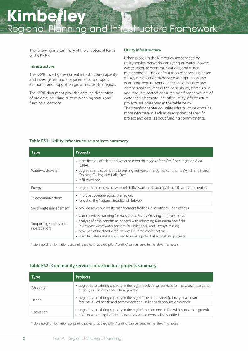
Utility infrastructure
Urban places in the Kimberley are serviced by utility service networks consisting of: water; power; waste water; telecommunications; and waste management. The configuration of services is based on key drivers of demand such as population and economic requirements. Large-scale industry and commercial activities in the agricultural, horticultural and resource sectors consume significant amounts of water and electricity. Identified utility infrastructure projects are presented in the table below. The specific chapter on utility infrastructure contains more information such as descriptions of specific project and details about funding commitments.
Table ES1: Utility infrastructure projects summary
Type Projects
Water/wastewater
• identification of additional water to meet the needs of the Ord River Irrigation Area (ORIA).
• upgrades and expansions to existing networks in Broome; Kununurra; Wyndham; Fitzroy Crossing; Derby; and Halls Creek.
• infill sewerage.
Energy • upgrades to address network reliability issues and capacity shortfalls across the region.
Telecommunications • improve coverage across the region.• rollout of the National Broadband Network.
Solid waste management • provide new solid waste management facilities in identified urban centres.
Supporting studies and investigations
• water services planning for Halls Creek, Fitzroy Crossing and Kununurra.• analysis of cost/benefits associated with relocating Kununurra borefield.• investigate wastewater services for Halls Creek, and Fitzroy Crossing.• provision of localised water services in remote destinations. • identify water services required to service potential agricultural projects.
* More specific information concerning projects (i.e. description/funding) can be found in the relevant chapters
Table ES2: Community services infrastructure projects summary
Type Projects
Education• upgrades to existing capacity in the region’s education services (primary, secondary and
tertiary) in line with population growth.
Health• upgrades to existing capacity in the region’s health services (primary health care
facilities, allied health and accommodation) in line with population growth.
Recreation• upgrades to existing capacity in the region’s settlements in line with population growth.• additional boating facilities in locations where demand is identified.
* More specific information concerning projects (i.e. description/funding) can be found in the relevant chapters
KimberleyRegional Planning and Infrastructure Framework
xiPart A: Regional Strategic Planning
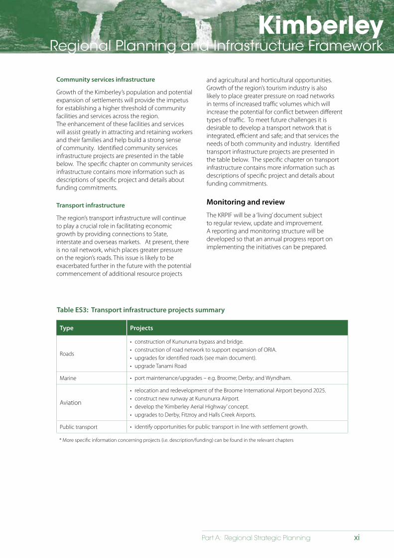
Community services infrastructure
Growth of the Kimberley’s population and potential expansion of settlements will provide the impetus for establishing a higher threshold of community facilities and services across the region. The enhancement of these facilities and services will assist greatly in attracting and retaining workers and their families and help build a strong sense of community. Identified community services infrastructure projects are presented in the table below. The specific chapter on community services infrastructure contains more information such as descriptions of specific project and details about funding commitments.
Transport infrastructure
The region’s transport infrastructure will continue to play a crucial role in facilitating economic growth by providing connections to State, interstate and overseas markets. At present, there is no rail network, which places greater pressure on the region’s roads. This issue is likely to be exacerbated further in the future with the potential commencement of additional resource projects
Table ES3: Transport infrastructure projects summary
Type Projects
Roads
• construction of Kununurra bypass and bridge.• construction of road network to support expansion of ORIA.• upgrades for identified roads (see main document).• upgrade Tanami Road
Marine • port maintenance/upgrades – e.g. Broome; Derby; and Wyndham.
Aviation
• relocation and redevelopment of the Broome International Airport beyond 2025. • construct new runway at Kununurra Airport.• develop the ‘Kimberley Aerial Highway’ concept.• upgrades to Derby, Fitzroy and Halls Creek Airports.
Public transport • identify opportunities for public transport in line with settlement growth.
* More specific information concerning projects (i.e. description/funding) can be found in the relevant chapters
and agricultural and horticultural opportunities. Growth of the region’s tourism industry is also likely to place greater pressure on road networks in terms of increased traffic volumes which will increase the potential for conflict between different types of traffic. To meet future challenges it is desirable to develop a transport network that is integrated, efficient and safe; and that services the needs of both community and industry. Identified transport infrastructure projects are presented in the table below. The specific chapter on transport infrastructure contains more information such as descriptions of specific project and details about funding commitments.
Monitoring and review
The KRPIF will be a ‘living’ document subject to regular review, update and improvement. A reporting and monitoring structure will be developed so that an annual progress report on implementing the initiatives can be prepared.
KimberleyRegional Planning and Infrastructure Framework
xii Part A: Regional Strategic Planning
xiiiPart A: Regional Strategic Planning
KimberleyRegional Planning and Infrastructure Framework
contents Chairman’s foreword iii Executive summary v Contents – Part A xiii
1 Introduction 1.1 Background 1
1.2 Kimberley vision 1
1.3 Purpose 1
1.4 Planning context 4
1.5 Planning principles 4
1.6 Engagement with native title parties 5
1.7 Structure and content 6
1.8 Related plans and strategies 8
1.9 Key plans and strategies 8
2 Cultural and natural heritage 2.1 Strategic direction 11
2.1.1 Overview 11
2.1.2 Goal statement 11
2.1.3 State Planning Strategy 12
2.2 Issues relating to cultural and natural heritage 12
2.3 Aboriginal cultural and natural heritage 12
2.3.1 Addressing Aboriginal cultural and natural heritage 12
2.4 Non-Aboriginal cultural and natural heritage 13
2.4.1 Addressing non-Aboriginal cultural and natural heritage 14
2.5 Planning initiatives – cultural and natural heritage 14
xiv Part A: Regional Strategic Planning
KimberleyRegional Planning and Infrastructure Framework
3 Natural environment 3.1 Strategic direction 16
3.1.1 Overview 16
3.1.2 Goal statement 16
3.1.3 State Planning Strategy 16
3.1.4 Initiatives and programs 16
3.2 Issues relating to environment 18
3.3 Environmental values and land use and development impacts 18
3.3.1 Landscape 18
3.3.2 Biodiversity 19
3.3.3 Water resources 21
3.3.4 Coastal environment 22
3.3.5 Marine environment 23
3.3.6 Adequacy of environmental data and collaboration 24
3.3.7 Aboriginal knowledge and land use and development 25
3.4 Planning initiatives – natural environment 26
4 Settlement 4.1 Strategic direction 27
4.1.1 Overview 27
4.1.2 Goal statement 27
4.1.3 State Planning Strategy 27
4.2 Issues relating to population/settlement 27
4.2.1 Population data 28
4.3 Population 28
4.3.1 Current population 28
4.3.2 Population growth 30
4.3.3 Key demographic trends 31
4.4 Settlement hierarchy 32
4.5 Regional city 33
4.5.1 Regional city – characteristics 33
4.5.2 Regional city – Broome 33
4.6 Regional centre 34
4.6.1 Regional centre – characteristics 34
4.6.2 Regional centre – Kununurra 35
xvPart A: Regional Strategic Planning
KimberleyRegional Planning and Infrastructure Framework
4.7 Sub-regional centre 37
4.7.1 Sub-regional centre – characteristics 37
4.7.2 Sub-regional centre – Derby 37
4.7.3 Sub-regional centre – Fitzroy Crossing 38
4.7.4 Sub-regional centre – Halls Creek 40
4.8 Towns 41
4.8.1 Town – characteristics 41
4.8.2 Town – Wyndham 42
4.8.3 Aboriginal towns 42
4.9 Settlements 43
4.10 Dwellings 43
4.10.1 Resident population accommodation 43
4.10.2 Transient/short stay accommodation 43
4.10.3 Public housing 44
4.11 Urban design 44
4.12 Land 46
4.12.1 Broome 46
4.12.2 Kununurra 46
4.12.3 Derby 47
4.12.4 Fitzroy Crossing 47
4.12.5 Halls Creek 48
4.12.6 Wyndham 48
4.12.7 Aboriginal towns 48
4.13 Planning initiatives – settlement 48
5 Economic development 5.1 Strategic direction 50
5.1.1 Overview 50
5.1.2 Goal statement 50
5.1.3 State Planning Strategy 50
5.2 Issues relating to the region’s economy 52
5.3 Economic significance of the Kimberley 52
5.3.1 Economic sectors 52
5.3.2 Significance of the region to the State’s economy 53
5.4 Economic diversification 53
xvi Part A: Regional Strategic Planning
KimberleyRegional Planning and Infrastructure Framework
5.5 Pastoral 54
5.5.1 Future economic development in the pastoral sector 54
5.5.2 Rangelands reform 55
5.6 Agricultural (excluding pastoral) 55
5.6.1 Future economic development opportunities in the agricultural sector 55
5.6.2 Ord River Irrigation Expansion Project 56
5.7 Tourism 56
5.7.1 Future economic development opportunities in the tourism sector 57
5.7.2 Accommodation and land 57
5.7.3 Aboriginal involvement 57
5.8 Resources 58
5.8.1 Future economic development opportunities in the resources sector 58
5.9 Fishing 60
5.9.1 Future economic development opportunities in the fishing sector 60
5.10 Pearling and aquaculture 60
5.10.1 Future economic development opportunities in the pearling/ aquaculture sectors 61
5.11 Defence 61
5.11.1 Future economic development opportunities in the defence sector 61
5.12 Services and commercial sectors 62
5.12.1 Future development opportunities in the service and commercial sectors 62
5.13 Supply chain completion 62
5.14 Industrial land 63
5.14.1 Future industrial land requirements 63
5.15 Labour force and employment 64
5.15.1 Future employment opportunities 64
5.15.2 Aboriginal employment 65
5.16 Planning initiatives – economic development 66
xviiPart A: Regional Strategic Planning
KimberleyRegional Planning and Infrastructure Framework
6 Implementing a sustainable framework 6.1 Strategic direction 67
6.1.1 Overview 67
6.1.2 Goal statement 67
6.2 Issues, opportunities, actions 67
6.3 Overarching issues 68
6.3.1 Engagement of Aboriginal people 68
6.3.2 Native title 68
6.3.3 Servicing to remote Aboriginal towns and settlements 69
6.3.4 Climate change 70
6.3.5 Basic raw materials 70
6.4 Governance 71
6.4.1 State Government 71
6.4.2 Department of Planning 71
6.4.3 Local planning strategies and schemes 71
6.4.4 Related strategies 71
6.4.5 Infrastructure 71
6.4.6 Consultation 71
6.5 Monitoring and review 71
List of acronyms 83
References 87
List of figures, tables and maps
Figure 1.1 Interpretation of State planning framework 4
Figure 1.2 State Planning Strategy 2050 structure 5
Figure 1.3 Related planning documents 8
Figure 1.4 State planning and development framework 9
Figure 2.1 Elements of cultural and natural heritage 11
Figure 4.1 WA Tomorrow forecasts and aspirational population growth scenarios 31
Figure 4.2 Broome – aspirational population scenarios (2011-2036) 34
Figure 4.3 Kununurra – aspirational population scenarios (2011-2036) 36
Figure 4.4: Derby − aspirational population targets (2011-2036) 38
Figure 4.5: Fitzroy Crossing − aspirational population targets (2011-2036) 39
Figure 4.6: Halls Creek − aspirational population targets (2011-2036) 40
xviii Part A: Regional Strategic Planning
KimberleyRegional Planning and Infrastructure Framework
Figure 5.1 Value of industry activities (2010/11) 52
Figure 5.2 Breakdown of employment by sector (2011) 65
Figure 6.1 Status of local planning initiatives 74
Table 2.1 Planning initiatives – cultural and natural heritage 15
Table 3.1 Planning initiatives – environment 26
Table 4.1: Estimated resident population by local government area (2012p) 28
Table 4.2: Population by urban centre locality 28
Table 4.3: Population of major Aboriginal Settlements 30
Table 4.4: Kimberley Regional Planning Committee aspirational growth rates (2011−2036) 30
Table 4.5: Kimberley settlement hierarchy 32
Table 4.6: Broome − aspirational population growth scenarios (2011−2036) 33
Table 4.7: Kununurra − aspirational population scenarios (2011−2036) 35
Table 4.8: Derby − aspirational population scenarios (2011–2036) 37
Table 4.9: Fitzroy Crossing − aspirational population scenarios (2011–2036) 39
Table 4.10: Halls Creek − aspirational population scenarios (2011–2036) 41
Table 4.11: Wyndham − population targets (based on 2.2% AAGR) (2011-2036) 42
Table 4.12: Aboriginal towns − aspirational population targets (based on 2.2% AAGR) (2011−2036) 42
Table 4.13: Planning initiatives – settlement 49
Table 5.1 Contribution of the Kimberley economy to Gross State Product 53
Table 5.2 Planning initiatives – economic development 66
Table 6.1 Planning initiatives – overarching issues 72
Table 6.2 Breakdown of KRPIF initiatives 73
Map 1.1 Strategy map 3
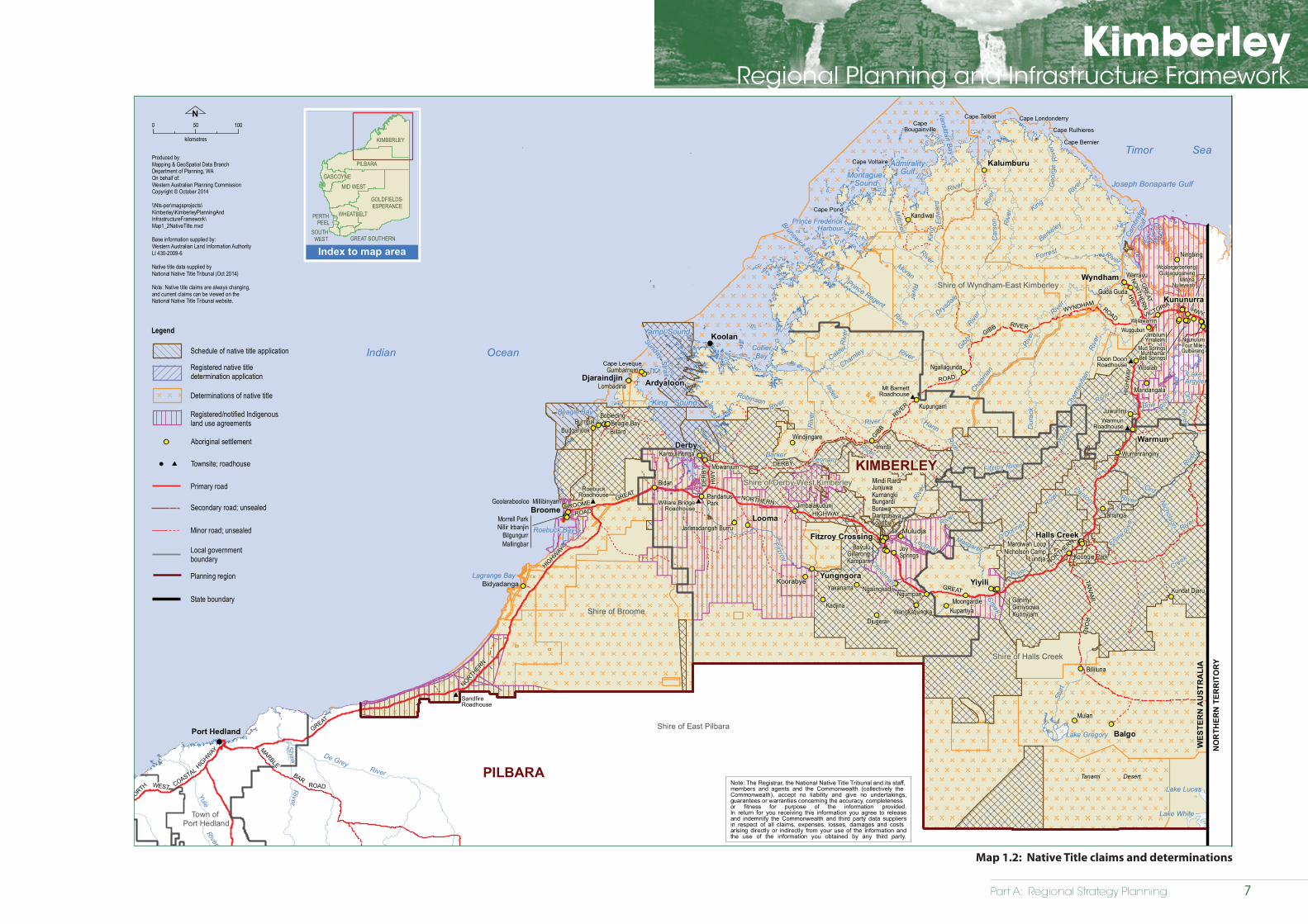
Map 1.2 Native Title claims and determinations 7
Map 3.1 Natural environment 17
Map 4.1 Settlement 29
Map 5.1 Economic development 51
Appendices
Appendix 1: Overview of mining and oil/gas projects 75
Appendix 2: Future employment types 81
Appendix 3: Mining legislation 82
KimberleyRegional Planning and Infrastructure Framework
1Part A: Regional Strategic Planning
1 Introduction
1.1 Background
The Kimberley’s physical landscape is characterised by tropical savannahs, spinifex country and coastal islands, significant coastal areas, flood plains and mud flats, diverse waterways and ancient landforms. The region’s biodiversity, which includes unique flora and fauna, is acknowledged internationally. Aboriginal people, who account for nearly half of the Kimberley’s current population, have a significant cultural legacy and associated custodial responsibilities across the region’s lands and waters, which include, for example: formal tenure and substantial land holdings such as pastoral stations, and traditional rights and interests that are recognised and protected under the Native Title Act 1993 (Cth) (NTA).
Historically, the region’s economy has expanded due to opportunities in the pearling, pastoral and agricultural industries. Settlements have grown in support of industry and population growth while investment in the region’s utility, community service and transport infrastructure networks has ensured access to services, connections within and outside the region and the means to export goods.
In recent times this remote part of northern Australia has experienced a range of land use pressures caused by the emergence of new prospects in the agricultural and horticultural sectors; heightened interest in the development of the region’s mineral and energy resources; and greater awareness of the potential for expanding the tourism industry. These new opportunities will provide significant impetus for economic and population growth driven by enhanced employment prospects and opportunities to improve utility, community and transport infrastructure.
Supporting and fostering growth will continue to present significant management challenges across the region in the future. While there is a strong argument for encouraging and facilitating growth there is also a pressing need to ensure the quality of the region’s comparative advantages − in particular, its unique natural environment − are not diminished. It is essential that management of the region’s resources be fully inclusive of the region’s Aboriginal people through the provision of opportunities to become more involved in all levels of planning, research and wider promotion and appreciation of their cultural and historical legacy.
1.2 Vision
The Kimberley aspires to a long term future transformed into one of the world’s most successful and sustainable region’s. The hallmarks of the success will be:
People – a well-housed, highly educated and healthy people enjoying high amenity in sustainable communities
Place – a place with outstanding infrastructure, services and governance set within a well-conserved and iconic natural environment
Prosperity – shared prosperity arising from the success of the region’s main drivers of economic opportunity: agriculture, Rangeland industries, tourism, minerals and energy.
1.3 Purpose
The Kimberley Regional Planning and Infrastructure Framework (KRPIF) defines a strategic direction for the future development of the Kimberley region over the next 25 years. The KRPIF has been developed in response to the desire by the community, stakeholders and government (at all levels) for a stronger decision-making context across the region, particularly the need for greater coordination of activities and management relating to existing and emerging land use patterns.

KimberleyRegional Planning and Infrastructure Framework
2 Part A: Regional Strategic Planning
Part A gives context to the scale and distribution of future population growth and investigates land supply/housing requirements, as well as identifying strategies for: facilitating economic growth; managing environmental impacts within the context of emerging impacts such as climate change. The KRPIF sets clear goals, identifies opportunities and defines clear and realistic planning initiatives.
KRPIF was prepared under the auspices of the Kimberley Regional Planning Committee (KRPC) of the Western Australian Planning Commission (WAPC). The KRPC was established in 2009 to advise the WAPC on land use planning issues in the region. The KRPC has a diverse membership including representation from State and local government, industry, Aboriginal groups and the broader community.
The enabling legislation for the WAPC and the context within which the KRPIF is prepared is the Planning and Development Act 2005. The scope of WAPC functions under that legislation, are:
• preparing a planning strategy for the State, and
• planning policies in respect of land-use (planning), transport planning and land development (planning); transport and infrastructure planning
During preparation of the KRPIF, the KRPC worked with Aboriginal groups including Prescribed Bodies Corporate (PBC) and the Kimberley Land Council (KLC) through the Traditional Owners Reference Group (TORG)1. The committee acknowledges the important role Aboriginal people generally, and native title parties in particular, will play in the future development and management of the region and welcomes the opportunity to continue strengthening partnerships and supporting the aspirations of Aboriginal people in planning for the future. Other stakeholders from State agencies, infrastructure providers and local government were also consulted.
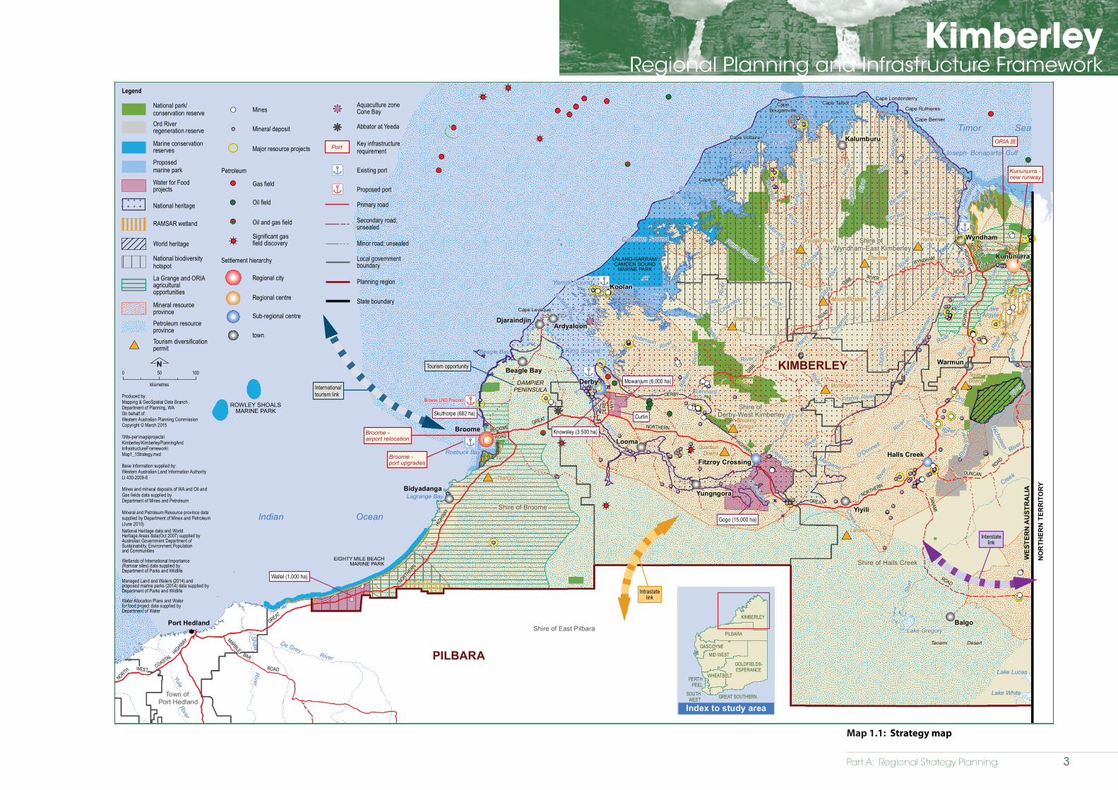
It is intended that the planning initiatives identified in the KRPIF will be reflected in the preparation of local planning strategies and local planning schemes across the region. Identified infrastructure projects, economic opportunities, and significant environmental and cultural assets are illustrated in Map 1.1.
In summary, key strategies include:
• having due regard to known heritage and native title interests and constraints;
• measuring and understanding population growth;
• defining a clear settlement hierarchy;
• focusing on land supply and known development constraints;
• providing affordable housing and greater housing choice;
• diversifying and expanding the economy;
• having due regard to the region’s Aboriginal and non-Aboriginal heritage; and
• conserving the environment.
1 The TORG was established by the Kimberley Regional Planning Committee (KRPC) with endorsement of the WAPC and DoP and comprises representatives of all current RNTPBCs of the Kimberley Region and the Kimberley Land Council representing claimants.
KRPIF Purpose
The Kimberley Regional Planning and Infrastructure Framework has been
prepared to identify regional infrastructure projects for a stronger, more robust
economy and community betterment. The KRPIF identifies a range of strategic
initiatives to help achieve comprehensive regional planning whilst having due regard to the region’s natural environment, history
and culture.
Part A: Regional Strategy Planning
KimberleyRegional Planning and Infrastructure Framework
Strategy map
Kimberley Regional Planning and Infrastructure Framework
Map 1.1WO ROAD
Wickham
TREAMPANNANICA
COASTAL
WEST HIGHWAY
HIGHWAY
GREAT
NO
RTH
ER
N
HIGHW
AY
ROAD
MARBLE
RO
AD
BAR
SPRINGSTelfer
River
Fortescue
River
Yule
River
Shaw
River
De GreyRiver
River
River
Swamp
Goodjadarnie
Anketell
Roebuck Bay
Lagrange Bay
King SoundBeagle Bay
Cape Leveque
Yampi Sound
Sunday Strait
CollierBay
Camden Sound
Brunswick Bay
Prince FrederickHarbour
Montague Sound
AdmiralityGulf
Vansittart Bay
Cape TalbotCapeBougainville
Cape Voltaire
Cape Pond
Cape Londonderry
Cape Rulhieres
Cape Bernier
Cam
brid
geG
ulf
Joseph Bonaparte Gulf
LakeArgyle
Tanami Desert
Lake Gregory
Lake Lucas
Lake White
Broome
Koolan
Derby
Wyndham
Fitzroy CrossingHalls Creek
BAR
NORTH
ROAD
GREAT
HIGHWAY
NORTHERN
GREATNORTHERN
HIGH
WAY
GIBB
RIVER
HWY
TANAMI
DUNCANROAD
ROAD
GIBB
WYNDHAM
ROAD
HWY
GREAT
NORTHERN
HIGHWAYR
iver
River
Riv
er
Lennard
River
Christmas
King
Riv
er
River
Edw
ard
King
Prince Regent
River
River
Gibb Rive
r
River
River
Riv
er
RiverRiver
Ord
River
Riv
er
River
Dunha
m
Rive
r
River
Fitzroy
Riv
er
ROWLEY SHOALSMARINE PARK
Warmun
Yiyili
Yungngora
Balgo
Kalumburu
ArdyaloonDjaraindjin
Beagle Bay
Bidyadanga
Looma
Internationaltourism link
DAMPIERPENINSULA
Interstatelink
Port Hedland
ROAD
Broome - airport relocation
Broome - port upgrades
Kununurra
Kununurra -new runway
ORIA III
Tourism opportunity
Browse LNG Precinct
LALANG-GARRAM/CAMDEN SOUND
MARINE PARK
EIGHTY MILE BEACHMARINE PARK
SKULL
NORTH
KarrathaRoebourne
Nullagine
Point Samson
NORTHERN
DERBY
RIVER
VICTORIA
DERB
Y
BROOME
Dur
ack
River
Hann
Riv
er
River
River
O'Donnell
Chapm
an
Cham
berla
in
River
River
Riv
er
Calder
Charnley
Bark
er
Rive
r
Nicholson
Berkeley
Leopold
Forrest
Elvi
re
Geo
rge
King
Robinson
River
River
RiverMoran
Panton
River
Bow
Fitzroy
Drysdale
Ord
Rive
r
Ord
River
Creek
Creek
Isdell
Rive
r
River
River
Mitchell
Wils
on
Car
son
Margaret
Stur
t
¿¿
¿
¿
¿
¿
Intrastatelink
kk
kk
Wallal (1,000 ha)
Curtin
Mowanjum (6,000 ha)
Knowsley (3.500 ha)
Gogo (15,000 ha)
Skuthorpe (682 ha)
Index to study area
Shire of East Pilbara
Indian Ocean
Timor Sea
WES
TER
N A
UST
RA
LIA
NO
RTH
ERN
TER
RIT
OR
Y
PILBARA
Town of Port Hedland
Shire of Broome
Shire of Derby-West Kimberley
Shire of Wyndham-East Kimberley
Shire of Halls Creek
0 50 100
kilometres
Nn|
n|
n|
Legend
National park/conservation reserve
Marine conservationreserves
Proposed marine park
Key infrastructurerequirement
RAMSAR wetland
National heritage
Petroleum resource province
Mineral resource province
Regional centre
Sub-regional centre
town
La Grange and ORIAagricultural opportunities
National biodiversity hotspot
Mines
Petroleum
Gas field
Oil field
Oil and gas field
Significant gasfield discoveryWorld heritage
!!
!!
!<
<
National Heritage data and WorldHeritage Areas data(Oct 2007) supplied byAustralian Government Department of Sustainability, Environment,Populationand Communities
Wetlands of International Importance(Ramsar sites) data supplied byDepartment of Parks and Wildlife
Managed Land and Waters (2014) andproposed marine parks (2014) data supplied byDepartment of Parks and Wildlife Water Allocation Plans and Waterfor food project data supplied byDepartment of Water
Settlement hierarchy
n|
n|
Local governmentboundary
Primary road
Planning region
State boundary
Existing port
Proposed portn|
n|
KIMBERLEY
Regional city
Secondary road;unsealed
Minor road; unsealed
Produced by:Mapping & GeoSpatial Data BranchDepartment of Planning, WAOn behalf of:Western Australian Planning CommissionCopyright © March 2015
\\Nts-per\magsprojects\Kimberley\KimberleyPlanningAndInfrastructureFramework\Map1_1Strategy.mxd
Base information supplied by:Western Australian Land Information AuthorityLI 430-2009-6
Mines and mineral deposits of WA and Oil andGas fields data supplied byDepartment of Mines and Petroleum
Mineral and Petroleum Resource province data supplied by Department of Mines and Petroleum(June 2010)
GREAT SOUTHERNSOUTHWEST
PERTHPEEL
MID WEST
GOLDFIELDS-ESPERANCE
GASCOYNE
PILBARA
KIMBERLEY
WHEATBELT
Port
#*
#*#*
Drysdale River
#* Mount Elizabeth
#*Charnley River
#*Mornington
BrookingSprings
#*Quanbun
Downs
#*
#*TexasDowns
#*Larrawa
Thangoo#*
Home Valley
Ellenbrae
#* Tourism diversificationpermit
Mineral deposit
Major resource projects
!!
!!
'*
kk
kk
Aquaculture zoneCone Bay
Abbator at YeedaOrd Riverregeneration reserve
Water for Foodprojects
Map 1.1: Strategy map
3
KimberleyRegional Planning and Infrastructure Framework
4 Part A: Regional Strategic Planning
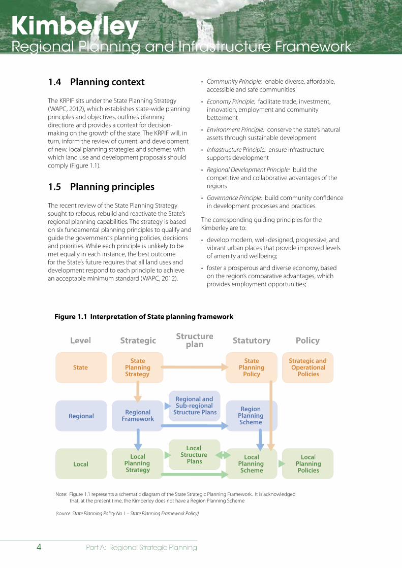
Figure 1.1 Interpretation of State planning framework
1.4 Planning context
The KRPIF sits under the State Planning Strategy (WAPC, 2012), which establishes state-wide planning principles and objectives, outlines planning directions and provides a context for decision-making on the growth of the state. The KRPIF will, in turn, inform the review of current, and development of new, local planning strategies and schemes with which land use and development proposals should comply (Figure 1.1).
1.5 Planning principles
The recent review of the State Planning Strategy sought to refocus, rebuild and reactivate the State’s regional planning capabilities. The strategy is based on six fundamental planning principles to qualify and guide the government’s planning policies, decisions and priorities. While each principle is unlikely to be met equally in each instance, the best outcome for the State’s future requires that all land uses and development respond to each principle to achieve an acceptable minimum standard (WAPC, 2012).
• Community Principle: enable diverse, affordable, accessible and safe communities
• Economy Principle: facilitate trade, investment, innovation, employment and community betterment
• Environment Principle: conserve the state’s natural assets through sustainable development
• Infrastructure Principle: ensure infrastructure supports development
• Regional Development Principle: build the competitive and collaborative advantages of the regions
• Governance Principle: build community confidence in development processes and practices.
The corresponding guiding principles for the Kimberley are to:
• develop modern, well-designed, progressive, and vibrant urban places that provide improved levels of amenity and wellbeing;
• foster a prosperous and diverse economy, based on the region’s comparative advantages, which provides employment opportunities;
Note: Figure 1.1 represents a schematic diagram of the State Strategic Planning Framework. It is acknowledged that, at the present time, the Kimberley does not have a Region Planning Scheme
StateState
PlanningStrategy
Level Strategic Structureplan Statutory Policy
Regional
Local
RegionalFramework
LocalPlanning Strategy
LocalPlanning Scheme
LocalPlanningPolicies
RegionPlanningScheme
StatePlanning
Policy
Strategic and Operational
Policies
Regional and Sub-regional
Structure Plans
Local Structure
Plans Local
LocalPlanning Strategy
LocalStructure
PlansLocal
Planning Scheme
LocalPlanningPolicies
Regional RegionalFramework
StateState
PlanningStrategy
StatePlanning
Policy
Strategic and Operational
Policies
Regional andSub-regional
Structure Plans RegionPlanningScheme
(source: State Planning Policy No 1 – State Planning Framework Policy)
KimberleyRegional Planning and Infrastructure Framework
5Part A: Regional Strategic Planning
• develop sustainable communities that are inclusive, accessible, healthy and safe with access to a range of employment, housing, cultural, educational and recreational opportunities;
• provide a high standard of infrastructure, including: interconnected transport; utility infrastructure; and community services (health and education);
• safeguard and enhance significant natural landscape assets and cultural heritage values;
• encourage sustainable well-designed development that is responsive to the region’s natural environment, including its climate; and
• develop governance structures to ensure the efficient and timely implementation of the KRPIF.
Planning initiatives that have been identified in the KRPIF respond to the strategic directions of the SPS.
1.6 Engagement with native title parties
A significant proportion of the Kimberley is covered by native title claims or determinations. The Native Title Act 1993 (Cth) (NTA) recognises and protects both claimed and determined rights and interests, that are registered under it. The NTA generally requires that the registered native title party is afforded the same rights as though they held ordinary green title in the respective area, depending
VISION: Sustained Growth and ProsperityDiverse Liveable Connected Collaborative
PRINCIPLESCommunity
EconomyEnvironment
InfrastructureRegional Development
Governance
STRATEGIC GOALSGlobal Competiveness
Sustainable CommunitiesConservation
Strong and Resilient RegionsInfrastructure Planning
STRATEGIC DIRECTIONS1. Economic development
1.1 Resource economy1.2 Education, training and knowledge transfer1.3 Tourism1.4 Agriculture and food1.5 Remote settlements1.6 Land availability
2. Physical infrastructure2.1 Movement of people, resources and information2.2 Water2.3 Energy2.4 Waste2.5 Telecommunications
3. Social infrastructure3.1 Spaces and places3.2 A�ordable living3.3 Health and wellbeing
4. Environment
5. Security
ACTION PLANNINGImplementation Evaluation
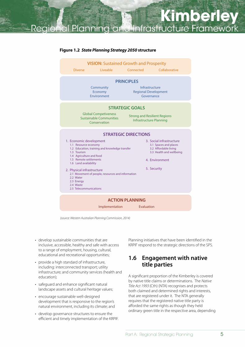
Figure 1.2 State Planning Strategy 2050 structure
(source: Western Australian Planning Commission, 2014)
KimberleyRegional Planning and Infrastructure Framework
6 Part A: Regional Strategic Planning
on the proposed development or type of future act. To the extent that native title exists within a relevant area, rights under the NTA with regard to development proposals may include, for example, the right to be notified, the right to be consulted, or the right to be negotiated with before the development proposal can go ahead.
Certain previous past government acts, such as the creation of freehold or other types of tenure that carry a right to exclude others, generally extinguish native title, meaning that there are no ongoing obligations for developers under the NTA in such areas.
It is an integral stage in land use and project planning therefore to identify whether native title exists in the area the subject of a development proposal and, if so, to apply the appropriate procedures and timeframes under the NTA.
Prescribed Bodies Corporate (PBCs) are those entities that are required under the NTA to be incorporated following a positive determination of native title to hold rights and interests in trust for the relevant group. The PBC is the appropriate entity for engagement on land use planning matters, to the extent that proposed development is likely to impact native title rights and interests within a specific determination area.
The Western Australian Planning Commission recognises that individual PBCs will increasingly play a role in the planning and development of the Kimberley into the future, just as Mirriuwung Gajerrong Corporation and Nyamba Buru Yawaru Ltd have influenced Kununurra and Broome respectively. PBCs will act both in roles as proponents wishing to develop land and in roles of key stakeholders affected by the development proposals of others, especially in areas where there are demands for urban expansion, infrastructure provision and economic development (refer to Map 1.2).
The WAPC’s Regional Planning Committee’s Traditional Owner Reference Group (TORG) provides for specific collaborative engagement between the WAPC and PBCs in the region. The TORG exists in addition to the usual means by which interested or affected parties in the Kimberley may participate in the planning system.
State Planning Policy 3.2: Aboriginal Settlements (SPP 3.2) also formally requires engagement with native title holders and registered claimants in the development and endorsement of town plans for Aboriginal communities, the majority of which, in the state are situated in the Kimberley region (see section 4.12.7).
1.7 Structure and content
Part A of the KRPIF is set out under the following chapters:
Chapter 1 – Introduction: establishes the purpose, vision, planning context and planning principles for the KRPIF and outlines its structure and related documents.
Chapter 2 – Cultural and natural heritage: provides an overview of the Kimberley’s rich Aboriginal and European heritage and provides opportunities and planning initiatives to facilitate responsible land use planning and development.
Chapter 3 – Natural environment: provides an overview of the region’s environmental assets and provides opportunities and planning initiatives to ensure these are protected.
Chapter 4 – Settlement: outlines a strategic direction for population growth and settlement in the Kimberley and provides opportunities and planning initiatives to achieve this.
Chapter 5 – Economic development: outlines the strategic direction for diversifying the Kimberley’s economy and provides opportunities and planning initiatives to achieve this.
Chapter 6 – Implementation of a sustainable framework: discusses issues, opportunities and planning initiatives required to implement the KRPIF and outlines requirements for governance, monitoring and review.
Part A: Regional Strategy Planning
KimberleyRegional Planning and Infrastructure Framework
Native title claims and determinations
Kimberley Regional Planning and Infrastructure Framework
Map 1.2
WickhamCOASTAL
WEST
HIGHW
AY
GREAT
NO
RTH
ER
N
HIGHWAY
ROAD
MARBLE
SPRINGS
Yule
River
Shaw De GreyRiver
River
Roebuck Bay
Lagrange Bay
King SoundBeagle Bay
Cape Leveque
Yampi Sound
SundayStrait
CollierBay
Brunswick Bay
Prince FrederickHarbour
Montague Sound
AdmiralityGulf
Vansittart Bay
Cape TalbotCape
Bougainville
Cape Voltaire
Cape Pond
Cape Londonderry
Cape Rulhieres
Cape Bernier
Cam
brid
geG
ulf
Joseph Bonaparte Gulf
LakeArgyle
Tanami Desert
Lake Gregory
Lake Lucas
Lake White
Broome
Koolan
Derby
Wyndham
Kununurra
Fitzroy Crossing Halls Creek
BAR
NORTH
Port Hedland
ROAD
GREAT
HIGHWAY
NORTHERN
GREAT
NORTHERN
HIG
HW
AY
GIBB
RIVER
HWY
TANAM
IR
OA
D
ROAD
GIBB
WYNDHAMROAD
HW
Y
GR
EAT
NORTHERN
HW
Y
River
Riv
er
Lennard
River
Christmas
King
Riv
er
River
Edw
ard
King
Prince Regent
River
River
Gibb Rive
r
River River
Riv
er
RiverRiver
Ord
River
Riv
er
River
Fitzroy
Calder
Bidyadanga
Muludja
Rive
r
Bow
NORTHERN
BROOME
DER
BY DERBY
VICTORIA
Warmun
Balgo
Yungngora
Looma
ArdyaloonDjaraindjin
Yiyili
RIVER
DER
BY
Dur
ack
River
Hann
Riv
er
River
River
O'Donnell
Chapm
an
Cham
berla
in
River
River
Riv
er
Riv
er
Charnley
Barker
Nicholson
Berkeley
Leopold
Forrest
Elvire
Geo
rge
Robinson
River
River
RiverMoran
Panton
River
Fitzroy
Drysdale
River
Ord
River
Creek
Creek
Isdell
Rive
r
River
River
Mitchell
Wils
on
Car
son
Margaret
Stur
t
Mulan
Woolah
Ningbing
Bidan
Mowanjum
Mandangala
Kandiwal
Wuggubun
Juwurlinji
Ganinyi
Billiluna
Wurrenranginy
Wijilawarrim
Djugerai
Mud SpringsMunthamar
Bell SpringsNgallagunda
Moongardie
Ngunulum
Ngumpan
Mingullatharndo
Bayulu
Kundat Djaru
Gillarong
Bobieding
Girriyoowa
Imintji
Wangkatjungka
Beagle Bay
Ngalingkadji
Yarrunga
Koorabye
Bell Springs
JoySprings
Kadjina
PandanusPark
Kalumburu
Kupungarri
JimbilumYirrallelm
Goolarabooloo Millibinyarri
Karnparri
Kupartiya
Koongie Park
Yakanarra
Jimbalakudunj
Karmulinunga
Windjingare
Jarlmadangah Burru
Lombadina
Mardiwah Loop
Budgarjook
Guda Guda
Nicholson Camp
Warrayu
Burawa
Nillir Irbanjin
Gumbarnum
Darlgunaya
Four Mile
Gulgagulganeng
Billard
Loanbun
Kurinyjarn
Burrguk
Morrell Park
BilgungurrMallingbar
MirimaNulleywah
Woolergerberleng
Gulberang
Lundja
Mindi RardiJunjuwaKurnangkiBungardi
Shire of East Pilbara
Indian Ocean
Legend
Local governmentboundary
Primary road
Aboriginal settlement
Timor Sea
WES
TER
N A
UST
RA
LIA
NO
RTH
ERN
TER
RIT
OR
Y
KIMBERLEY
PILBARA
Town of Port Hedland
Shire of Broome
Shire of Derby-West Kimberley
Shire of Wyndham-East Kimberley
Shire of Halls Creek
Planning region
State boundary
Townsite; roadhouse
Willare BridgeRoadhouse
Mt BarnettRoadhouse
WarmunRoadhouse
Doon DoonRoadhouse
RoebuckRoadhouse
SandfireRoadhouse
Secondary road; unsealed
Minor road; unsealed
0 50 100
kilometres
N
Produced by:Mapping & GeoSpatial Data BranchDepartment of Planning, WAOn behalf of:Western Australian Planning CommissionCopyright © October 2014
\\Nts-per\magsprojects\Kimberley\KimberleyPlanningAndInfrastructureFramework\Map1_2NativeTitle.mxd
Base information supplied by:Western Australian Land Information AuthorityLI 430-2009-6
Native title data supplied byNational Native Title Tribunal (Oct 2014)
Note: Native title claims are always changing,and current claims can be viewed on the National Native Title Tribunal website.
GREAT SOUTHERNSOUTH
WEST
Index to map area
PERTHPEEL
MID WEST
GOLDFIELDS-ESPERANCE
GASCOYNE
PILBARA
KIMBERLEY
WHEATBELT
Registered native title determination application
Schedule of native title application
Determinations of native title
Registered/notified Indigenousland use agreements
Note: The Registrar, the National Native Title Tribunal and its staff,members and agents and the Commonwealth (collectively the Commonweath), accept no liability and give no undertakings,guarantees or warranties concerning the accuracy, completeness or fitness for purpose of the information provided.In return for you receiving this information you agree to releaseand indemnify the Commonwealth and third party data suppliersin respect of all claims, expenses, losses, damages and costs arising directly or indirectly from your use of the information andthe use of the information you obtained by any third party.
Map 1.2: Native Title claims and determinations
7

KimberleyRegional Planning and Infrastructure Framework
8 Part A: Regional Strategic Planning
Figure 1.3 Related planning documents
RegionalHotspots
Kimberley RegionalPro�le
Kimberley Regional Planning&
Infrastructure Framework
State PlanningStrategy
Kimberley RegionalPro�le
State PlanningStrategy
Kimberley Regional Planning&
Infrastructure Framework
RegionalHotspots
1.8 Related plans and strategies
A number of related plans, strategies and initiatives, together with the KRPIF, make a valuable contribution to the region’s transformation (Figure 1.3).
The Kimberley Regional Profile contains detailed information on the economic, social and environmental elements; as well as other aspects of the region and is supported by a series of regional maps. The profile focuses on historic and current trends.
Regional Hotspots publications are prepared under the WAPC’s Urban Development Program to provide information on the availability of land for future residential, industrial and commercial development in major centres across the state, including the Kimberley. The program identifies the planning and infrastructure coordination needed to meet demand in selected regional centres across Western Australia. To date, these documents have been prepared for Broome (WAPC, 2008), Kununurra (WAPC, 2008), Fitzroy Crossing (WAPC, 2008), and Halls Creek (WAPC, 2008).
1.9 Key plans and strategies
Kimberley Science and Conservation Strategy
The State Government is now implementing the actions of the Kimberley Science and Conservation Strategy (KSCS). Preparing the Strategy involved State Government agencies, Aboriginal groups, pastoralists, non-government organisations and individuals who are involved in the conservation of the Kimberley. The strategy does not replace existing legislative responsibilities or the activities of a range of stakeholders, but assists in integrating them.
The KSCS recognises the need to protect the region’s natural and cultural values as it fulfils its economic potential. The top five strategic outcomes that will be delivered are:
1. establishment of Kimberley Wilderness Parks (marine and terrestrial);
2. adopting a landscape approach to conservation to manage fire, introduced animals and weeds;
3. training and employment for Aboriginal rangers;
4. investing in knowledge and making information accessible; and
5. providing a major boost to nature-based tourism.
National Heritage Assessment of the West Kimberley
Following a 2008 agreement between the Commonwealth and Western Australian Governments, the Australian Heritage Council has undertaken an assessment of the heritage values of the west Kimberley in accordance with the
KimberleyRegional Planning and Infrastructure Framework
9Part A: Regional Strategic Planning
requirements of the Environment Protection and Biodiversity Conservation Act 1999 (EPBC 1999). The Council has identified and comprehensively assessed a range of national heritage values throughout the region.
The West Kimberley was officially placed on the National Heritage Listing in mid-2011. The listing will protect Aboriginal, historic, cultural, scientific, aesthetic and natural heritage values that have been assessed as having ‘outstanding’ heritage values. The region provides a significant contribution to Australian heritage and the listing will ensure that those values will be protected under Federal environmental legislation.
Kimberley Regional Investment Blueprint
The Kimberley Development Commission (KDC) is preparing a comprehensive Regional Investment Blueprint (“the Blueprint”) for the Kimberley region with input from public, private, not-for profit and local community sectors.
The Blueprint is mandated by:
a) the Review of Regional Development Commissions (Duncan Review);
b) Cabinet’s response to the Duncan Review; and
c) The Regional Development Council.
The Blueprint, which complements the KRPIF, will be developed through rigorous analysis that focusses on ‘transforming’ the Kimberley over the next 25 years. Importantly, the KRPIF and Blueprint share a common vision.
The transformation will be by a series of ‘agendas’ that will change the Kimberley. These include:
1. regional leadership and development-readiness;
2. enhancing the capability of the services sector;
3. aboriginal advancement;
4. industry and resources development;
5. developing regional centres; and
6. infrastructure for driving growth.
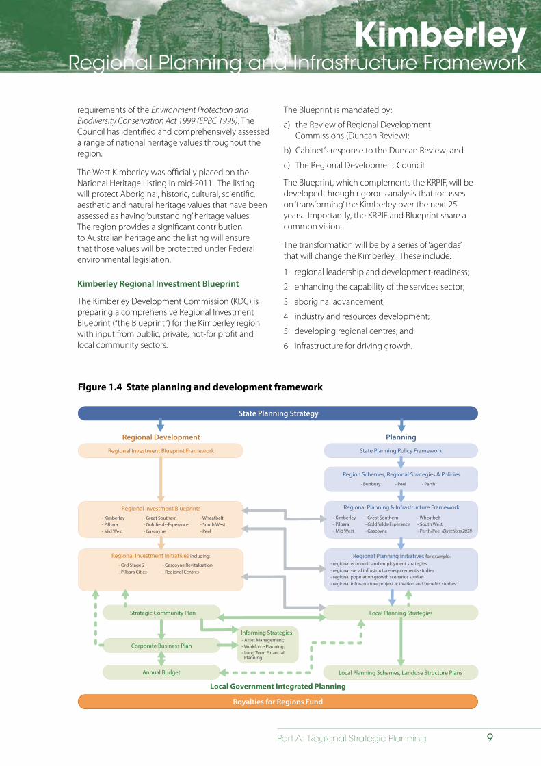
Figure 1.4 State planning and development framework
State Planning Strategy
Regional Development Planning
Royalties for Regions Fund
Local Government Integrated Planning
Regional Investment Blueprint Framework State Planning Policy Framework
Strategic Community Plan
Corporate Business Plan
Annual Budget
Local Planning Strategies
Local Planning Schemes, Landuse Structure Plans
Region Schemes, Regional Strategies & Policies
Regional Planning & Infrastructure Framework
Regional Planning Initiatives for example:Regional Investment Initiatives including:
Regional Investment Blueprints
Informing Strategies:
- Kimberley- Pilbara- Mid West
- Great Southern- Gold�elds-Esperance- Gascoyne
- Wheatbelt- South West- Peel
- Ord Stage 2- Pilbara Cities
- Gascoyne Revitalisation- Regional Centres
- Asset Management;- Workforce Planning;- Long Term Financial
Planning
- Bunbury - Peel - Perth
- Kimberley- Pilbara- Mid West
- Great Southern- Gold�elds-Esperance- Gascoyne
- Wheatbelt- South West- Perth/Peel (Directions 2031)
- regional economic and employment strategies- regional social infrastructure requirements studies- regional population growth scenarios studies- regional infrastructure project activation and bene�ts studies
KimberleyRegional Planning and Infrastructure Framework
10 Part A: Regional Strategic Planning
A critical component of the Blueprint will be setting measurable targets for each of the key strategies that have been identified to transform the region. These measures include ‘aspirational’ targets.
The diagram (Figure 1.4) shows the relationship between the Regional PIFs and the Regional Investment Blueprints. These documents will be prepared for each region to provide a consistent message to government in relation to infrastructure and economic development priorities.
Northern Ministerial Forum
In 2010, the Federal Government established the Northern Ministerial Forum. It consists of the state regional development Ministers from Western Australia, Northern Territory, Queensland and from the Federal Government. The purpose of the forum is to collaborate and encourage the development of northern Australia, including the Kimberley.
Regional Development Australia
In recognition of the need for better coordination leading to improved economic, social and community outcomes, the Kimberley branch of Regional Development Australia (RDA) has been funded by the Federal Government to deliver on five key areas, including:
1. community engagement and consultation;
2. informed regional planning;
3. enhanced whole-of-government approach;
4. promotion of government programs; and
5. community and economic development.
On the basis of consultation with key regional stakeholders, existing plans, internal resources and networks, the Kimberley RDA has identified the following strategic priorities for the region: economic development; health; education; youth; environment; industry and Aboriginal issues. Specific implementation activities to achieve outcomes in these priority areas are detailed in a business plan for the Kimberley RDA. This document sets out the strategic framework under which the Kimberley RDA will operate.
Regional Business Plan
Local government authorities within the Kimberley region have developed a suite of business and community plans together with Local Planning Strategies. The intent of these documents is to identify the aspirational and future planning needs for their respective areas. The Kimberley Zone and Regional Collaborative Group has also developed a Regional Business Plan.

KimberleyRegional Planning and Infrastructure Framework
11Part A: Regional Strategic Planning
2 Cultural and natural heritage
2.1 Strategic direction
2.1.1 Overview
The Kimberley has a rich diversity of culture and heritage, which assists in the creation of a unique ‘sense of place’ - engendering particular areas, places, buildings and landscapes with special qualities and meaning for individuals and communities. The WAPC recognises that not all individuals or communities necessarily share the same sense of place for a given area. It therefore aims for a planning system in the Kimberley that is inclusive and facilitates responsible development that takes into consideration, and gives due regard to, the region’s diverse cultural values.
There are many different elements that make up natural heritage and cultural heritage as illustrated in Figure 2.1.
2.1.2 Goal statement
To have due regard to significant cultural and natural heritage values of the Kimberley as identified through the Heritage Tourism Strategy (WA) 2006, State Cultural Heritage Policy (WA) 2011, Aboriginal Heritage Act 1972, Heritage of Western Australia Act 1990 and Native Title Act 1993 to facilitate responsible land use and development.
Figure 2.1: Elements of cultural and natural heritage
Natural heritage Cultural heritage
Examples: Examples:
National parks
Conservation reserves
World and national heritage listings
Wetlands and waterways
Natural history sites
Physical landscapes
Waterfalls
Historic sites
Industrial heritage sites
Heritage districts
Archaeological sites
Built form heritage
KimberleyRegional Planning and Infrastructure Framework
12 Part A: Regional Strategic Planning
The following opportunity has been identified to address cultural and natural heritage across the region:
• consider changes to local and state planning policies that foster responsible development through better recognition of significant cultural and natural heritage values, as identified through other policy and legislation.
2.1.3 State Planning Strategy
The State Planning Strategy defines the following objectives that relate specifically to management of the region’s cultural and natural heritage:
• Tourism: to enable a range of experiences that the State’s lifestyle, prosperity, culture and natural environment has to offer.
• Remote Settlements: to maintain economic and community development through improved connectivity and cultural support.
2.2 Issues relating to cultural and natural heritage
The key issues relating to cultural and natural heritage in the Kimberley are:
• How significant Aboriginal and non-Aboriginal cultural and natural heritage opportunities and constraints can be better identified in strategic land use planning.
• For land use planning and development control to have due regard to identified significant cultural and natural heritage values.
The following opportunities have been identified for the conservation of Aboriginal culture and natural heritage values through land use planning:
• working within the ambit of the Planning and Development Act 2005 and complimenting rather than duplicating existing legislation such as the AHA and NTA;
• working respectfully and productively with native title parties;
• promoting improved access to the region’s Aboriginal cultural and natural heritage sites;
• creating national Aboriginal arts and cultural precincts to showcase the Kimberley’s Aboriginal arts and culture, and host Aboriginal arts and cultural displays and events from other jurisdictions; and
• ensuring suitable engagement between native title parties and the Department of Planning, such as through the TORG.
2.3.1 Addressing Aboriginal cultural and natural heritage
Existing legislative frameworks, such as the Native Title Act 1993 (Cth) (NTA) and the Aboriginal Heritage Act 1972 (WA) (AHA) will continue to play the primary role in recognising and protecting the region’s Aboriginal cultural and natural heritage. Town planning relies on this legislation to assist in identifying both opportunities and constraints. The recording and registration of significant sites or areas occurs via the AHA as a precursor to being identified or reflected in the State’s land use planning system, which captures known heritage and native title opportunities and constraints.
The key overarching issue that needs to be addressed when planning specifically for Aboriginal culture and heritage is town planning schemes and strategies have traditionally been limited to town boundaries. In the near future, these schemes and strategies will extend to cover the entire Shire and will need to consider inclusion of culturally and historically important sites, as registered under the AHA and NTA.
2.3 Aboriginal cultural and natural heritage
The Kimberley region has a complex and diverse indigenous heritage dating back millennia. There are an estimated 22 Aboriginal language groups across the Kimberley today, a reflection of the region’s varied and robust cultures.

KimberleyRegional Planning and Infrastructure Framework
13Part A: Regional Strategic Planning
2.4 Non-Aboriginal cultural and natural heritage
There is evidence that regular visits were made to northern Australia by Chinese traders, Portuguese and Papuan people prior to the 1600s. However it was Indonesian people from the trading centre of Macassar, who were the most regular visitors. The Macassan people traded objects with the Aboriginal people and also influenced art, stories, dance, language and ritual in the region.
In the 1600s Abel Tasman landed on the Kimberley coast en route to Indonesia. The presence of numerous ship wrecks since that time indicate a rich maritime history through the 18th century.
Settlement by pastoralists occurred around 1880, with the historically significant pearling industry establishing near Broome in the late 1800s. The pearling industry was pivotal in attracting a diverse range of cultures, including people from Japan, China, and south-east Asia, to Broome and remains an important industry and tourist attraction. Vestiges of the pearling industry can still be seen throughout the town. In 1885, Halls Creek became the site of Western Australia’s first gold rush. The Ord River Irrigation Area (ORIA) Project has developed over the last 70 years.
In terms of natural heritage values for the non-Aboriginal population, the Kimberley coast is recognised for the William Dampier landing place (1688) around Pender Bay, Karrakatta Bay, King Sound and the Buccaneer Archipelago. The surrounding environment observed by Dampier is substantially unmodified since the 1688 landing. This coastline (which includes islands, peninsulas and inlets) is representative of the dominant coastal landform type without evidence of significant modification by development. Similarly, the region’s natural landscapes provide highly significant aesthetic and historic values as they display an array of colours, inspirational scenery, topographic and geological history.
KimberleyRegional Planning and Infrastructure Framework
14 Part A: Regional Strategic Planning
2.4.1 Addressing non-Aboriginal cultural and natural heritage
In minimising risk of land use conflict regarding the region’s non-Aboriginal cultural and natural heritage, there will be a need to ensure that pastoral lease homesteads and pearling operations, including outbuildings and infrastructure, receive greater recognition on State and local government heritage lists and inventories.
Furthermore, responsible land use and development will ensure due regard to highly valued historic and natural landscapes to reduce risk associated with inappropriate development such as unregulated tourism activities.
The following opportunities have been identified to conserve and suitably manage the cultural integrity of the region’s non-Aboriginal legacy:
• The identification and management, without duplicating existing protective regimes, of:
- places of significance; art, historic places and landscapes;
- the region’s pastoral and pearling heritage particularly pastoral homesteads and significant pearl farms; and
- the region’s resource development heritage, in particular gold mines in the vicinity of the old Halls Creek townsite.
• Encouraging creative partnerships between all levels of government and the private sector for shared ownership, responsibility and development of strategies that promote and enhance the region’s non-Aboriginal cultural heritage.
• Celebrating and cherishing the historical development of the Kimberley, from early non-Aboriginal exploration by land and sea, the gold rush in the East Kimberley, the establishment of the pastoral industry and the pearling industry is a key factor in facilitating responsible development of the region.
2.5 Planning initiatives – cultural and natural heritage
Planning initiatives relating to cultural and natural heritage are presented in Table 2.1.
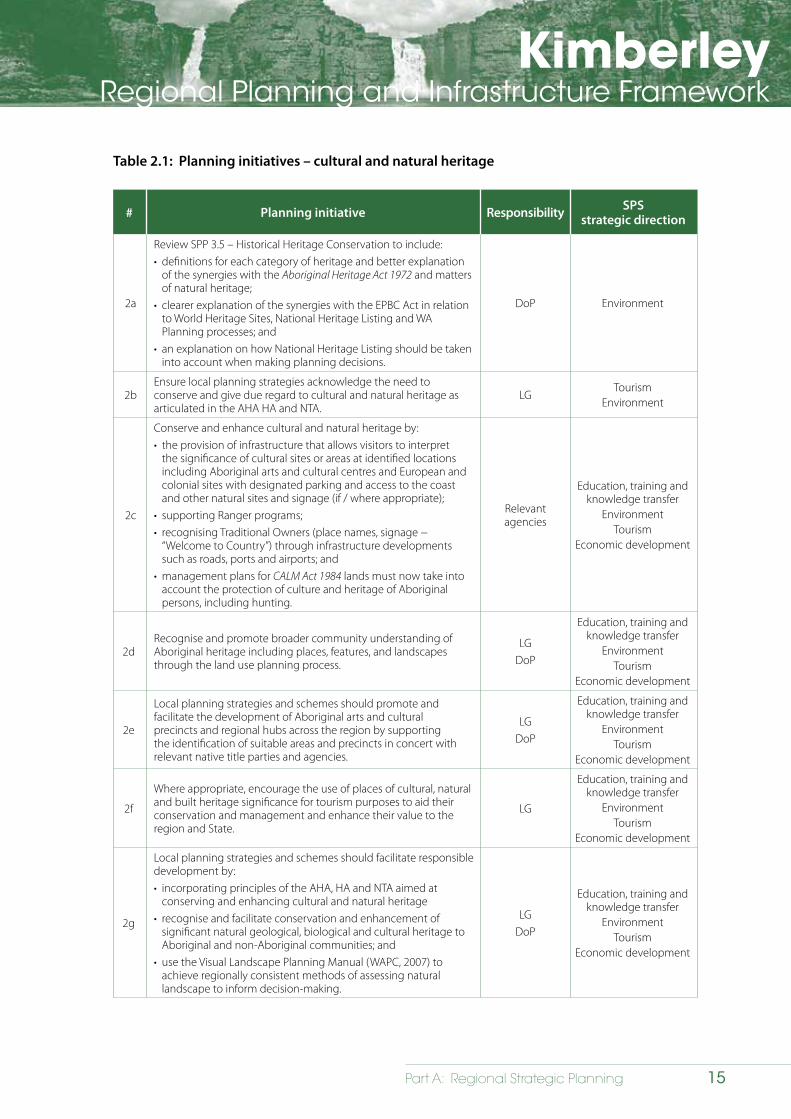
KimberleyRegional Planning and Infrastructure Framework
15Part A: Regional Strategic Planning
Table 2.1: Planning initiatives – cultural and natural heritage
# Planning initiative Responsibility SPSstrategic direction
2a
Review SPP 3.5 – Historical Heritage Conservation to include:• definitions for each category of heritage and better explanation
of the synergies with the Aboriginal Heritage Act 1972 and matters of natural heritage;
• clearer explanation of the synergies with the EPBC Act in relation to World Heritage Sites, National Heritage Listing and WA Planning processes; and
• an explanation on how National Heritage Listing should be taken into account when making planning decisions.
DoP Environment
2bEnsure local planning strategies acknowledge the need to conserve and give due regard to cultural and natural heritage as articulated in the AHA HA and NTA.
LGTourism
Environment
2c
Conserve and enhance cultural and natural heritage by:• the provision of infrastructure that allows visitors to interpret
the significance of cultural sites or areas at identified locations including Aboriginal arts and cultural centres and European and colonial sites with designated parking and access to the coast and other natural sites and signage (if / where appropriate);
• supporting Ranger programs;• recognising Traditional Owners (place names, signage −
“Welcome to Country”) through infrastructure developments such as roads, ports and airports; and
• management plans for CALM Act 1984 lands must now take into account the protection of culture and heritage of Aboriginal persons, including hunting.
Relevant agencies
Education, training and knowledge transfer
EnvironmentTourism
Economic development
2dRecognise and promote broader community understanding of Aboriginal heritage including places, features, and landscapes through the land use planning process.
LGDoP
Education, training and knowledge transfer
EnvironmentTourism
Economic development
2e
Local planning strategies and schemes should promote and facilitate the development of Aboriginal arts and cultural precincts and regional hubs across the region by supporting the identification of suitable areas and precincts in concert with relevant native title parties and agencies.
LGDoP
Education, training and knowledge transfer
EnvironmentTourism
Economic development
2f
Where appropriate, encourage the use of places of cultural, natural and built heritage significance for tourism purposes to aid their conservation and management and enhance their value to the region and State.
LG
Education, training and knowledge transfer
EnvironmentTourism
Economic development
2g
Local planning strategies and schemes should facilitate responsible development by:• incorporating principles of the AHA, HA and NTA aimed at
conserving and enhancing cultural and natural heritage • recognise and facilitate conservation and enhancement of
significant natural geological, biological and cultural heritage to Aboriginal and non-Aboriginal communities; and
• use the Visual Landscape Planning Manual (WAPC, 2007) to achieve regionally consistent methods of assessing natural landscape to inform decision-making.
LGDoP
Education, training and knowledge transfer
EnvironmentTourism
Economic development
KimberleyRegional Planning and Infrastructure Framework
16 Part A: Regional Strategic Planning
3 Natural environment
3.1 Strategic direction
3.1.1 Overview
The Kimberley region is defined by unique terrestrial and marine ecosystems with high biodiversity set in rugged and remote landscapes. The region is renowned for its environmental values, many of which have been identified for their regional, state, national and international significance (refer to Map 3.1).
The environment also contributes significantly to the region’s cultural values given its importance to the Aboriginal people, who have strong traditional and spiritual connections to the region’s biodiversity, landscapes and natural resource assets, including water. Many Aboriginal people have maintained connection to country and custodianship of the land for millennia.
The region’s environmental values are likely to play a significant role in shaping the Kimberley through experience-based tourism and diversification of existing sectors (Chapter 5 – Economy). In 2011, the Government of Western Australia released the Kimberley Science and Conservation Strategy (DEC, 2011) to provide a strategic path for conservation of the region’s natural and cultural values while recognising the potential economic growth opportunities for the region. The KSCS states that the Kimberley has increased recognition in its development potential, including:
• development of rich offshore and onshore petroleum resources;
• expansion of the Ord and West Kimberley irrigation projects;
• population growth;
• support pastoral leases to diversify their operations; and
• increasing international profile and visitor numbers.
Each of these may impact on the region’s environment and need to be carefully managed and planned.
3.1.2 Goal statement
The high conservation values and integrity of the natural environment must be conserved through effective planning while also facilitating economic growth and diversification.
3.1.3 State Planning Strategy
The State Planning Strategy 2012 has defined a series of objectives that relate to the environment, which will guide future planning in the Kimberley region:
• Environment - to conserve biodiversity and manage the State’s natural resources in a sustainable manner.
• Tourism - to access and enhance a range of experiences unique to the State.
• Water – to support WA’s growth and development by sustainably managing the availability and quality of water while maintaining a healthy, diverse and well-managed water environment.
3.1.4 Initiatives and programs
The following State and Commonwealth initiatives and programs are relevant to this chapter of the KRPIF:
• Kimberley Science and Conservation Strategy (DEC, 2011);
• National Landscapes Program - Kimberley National Landscape Experience Development Strategy (Commonwealth 2010);
• National Wildlife Corridors Plan (Commonwealth 2012);
• Rangelands Reform Program (DoL, 2011);
• Indigenous Protected Areas (ongoing with Commonwealth); and
• Northern Australia Sustainable Futures program.
Refer to the Kimberley Regional Profile for further information.
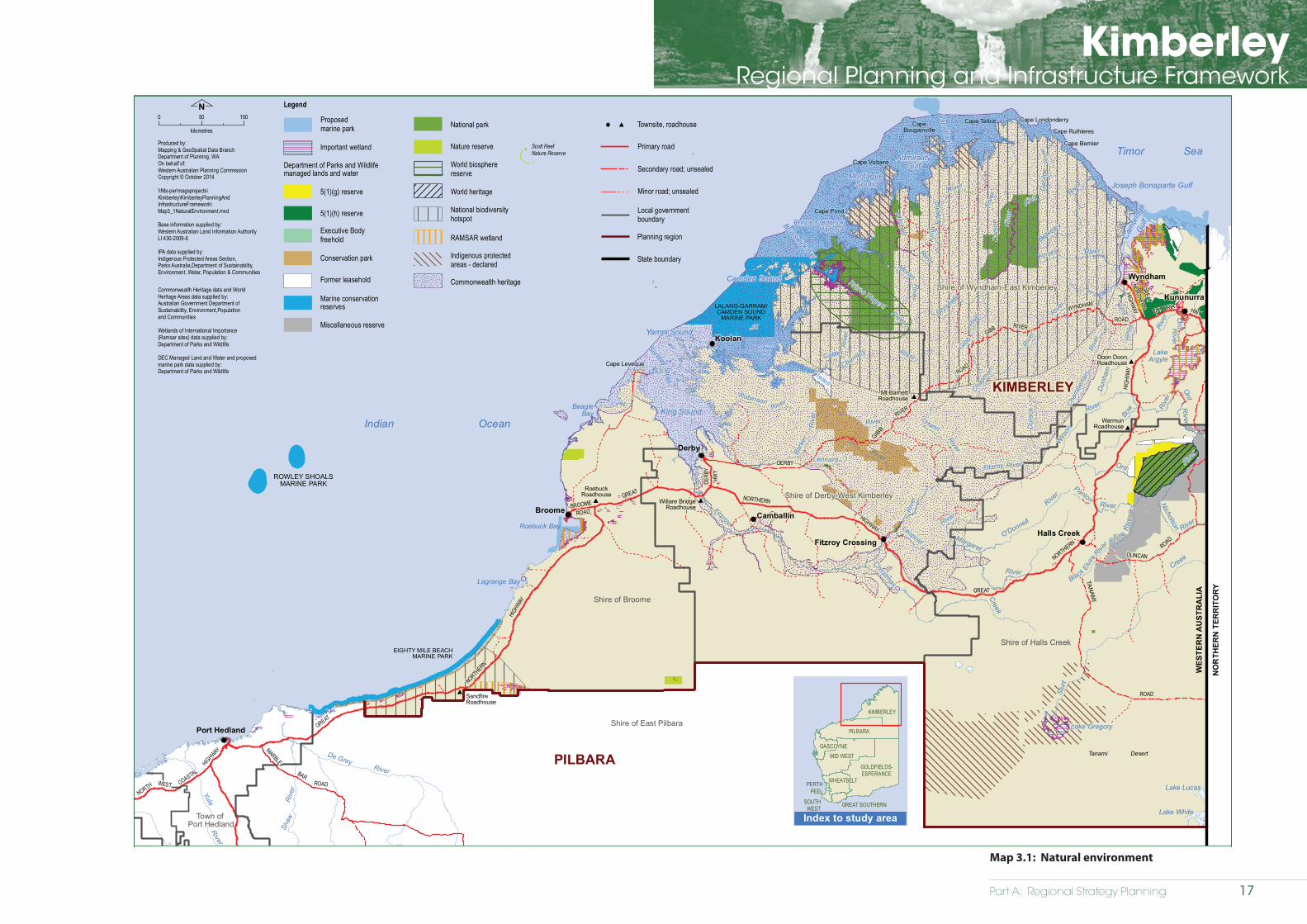
Part A: Regional Strategy Planning
KimberleyRegional Planning and Infrastructure Framework
Natural environment
Kimberley Regional Planning and Infrastructure Framework
Map 3.1
WickhamCOASTAL
WEST
HIGHWAY
GREAT
NO
RTH
ER
N
HIGHW
AY
ROAD
MARBLE
Yule
River
Shaw
De GreyRiver
River
Roebuck Bay
Lagrange Bay
King SoundBeagle
Bay
Cape Leveque
Yampi Sound
SundayStrait
CollierBay
Camden Sound
Brunswick Bay
Prince FrederickHarbour
Montague Sound
AdmiralityGulf
Vansittart Bay
Cape TalbotCapeBougainville
Cape Voltaire
Cape Pond
Cape Londonderry
Cape Rulhieres
Cape Bernier
Cam
brid
geG
ulf
Joseph Bonaparte Gulf
LakeArgyle
Tanami Desert
Lake Gregory
Lake Lucas
Lake White
Broome
Koolan
Derby
Wyndham
Kununurra
Fitzroy CrossingHalls Creek
Camballin
BAR
NORTH
Port Hedland
ROAD
GREAT
HIGHWAY
NORTHERN
GREAT
NORTHERN
HIGH
WAY
GIBB
RIVER
HWY
TANAM
I
ROAD
DUNCANROAD
ROAD
GIBB
WYNDHAM
ROAD
HWY
GREAT
NORTHERN
HIGHWAYR
iver
River
Riv
er
LennardRiver
Christmas
King
Riv
er
River
Edw
ard
King
Prince Regent
River
River
Gibb Rive
r
River
River
Riv
er
Black
Elvir
e
RiverRiver
Ord
River
Riv
er
River
Dun
ham
Rive
r
River
Fitzroy
Riv
er
ROWLEY SHOALSMARINE PARK
Scott Reef Nature Reserve
EIGHTY MILE BEACHMARINE PARK
LALANG-GARRAM/CAMDEN SOUND
MARINE PARK
NORTH
Roebourne
Point Samson
NORTHERN
DERBY
RIVER
VICTORIA
DERB
Y
BROOME
Dur
ack
River
Hann
Riv
er
River
River
O'Donnell
Chapm
an
Cham
berla
in
River
River
Riv
er
Calder
Charnley
Bark
er
Rive
r
Nicholson
Berkeley
Leopold
Forrest
Elvire
Geo
rge
King
Robinson
Riv
er
River
RiverMoran
Panton
River
River
Bow
Fitzroy
Drysdale
Ord
River
Ord River
Creek
Creek
Isdell
Riv
er
River
River
Mitchell
Wils
on
Car
son
Margaret
Stur
t
Index to study area
Shire of East Pilbara
Indian Ocean
Local governmentboundary
Primary road
Secondary road; unsealed
Minor road; unsealed
Timor Sea
WES
TER
N A
UST
RA
LIA
NO
RTH
ERN
TER
RIT
OR
Y
PILBARA
Town of Port Hedland
Shire of Broome
Shire of Derby-West Kimberley
Shire of Wyndham-East Kimberley
Shire of Halls Creek
Planning region
State boundary
0 50 100
kilometres
N Legend
Proposed marine park
World biosphere reserve
RAMSAR wetland
Commonwealth heritage
National biodiversity hotspot
World heritage
Commonweatlh Heritage data and WorldHeritage Areas data supplied by:Australian Government Department of Sustainability, Environment,Populationand Communities
Wetlands of International Importance(Ramsar sites) data supplied by:Department of Parks and Wildlife
DEC Managed Land and Water and proposedmarine park data supplied by:Department of Parks and Wildlife
Important wetland
5(1)(g) reserve
Department of Parks and Wildlifemanaged lands and water
5(1)(h) reserve
Executive Bodyfreehold
Conservation park
Former leasehold
Marine conservationreserves
National park
Miscellaneous reserve
Nature reserve
Indigenous protectedareas - declared
Produced by:Mapping & GeoSpatial Data BranchDepartment of Planning, WAOn behalf of:Western Australian Planning CommissionCopyright © October 2014
\\Nts-per\magsprojects\Kimberley\KimberleyPlanningAndInfrastructureFramework\Map3_1NaturalEnvironment.mxd
Base information supplied by:Western Australian Land Information AuthorityLI 430-2009-6
IPA data supplied by:Indigenous Protected Areas Section,Parks Australia,Department of Sustainability,Environment, Water, Population & Communities
GREAT SOUTHERNSOUTHWEST
PERTHPEEL
MID WEST
GOLDFIELDS-ESPERANCE
GASCOYNE
PILBARA
KIMBERLEY
WHEATBELT
Townsite, roadhouse
KIMBERLEY
RoebuckRoadhouse
Willare BridgeRoadhouse
Doon DoonRoadhouse
WarmunRoadhouse
Mt BarnettRoadhouse
SandfireRoadhouse
Map 3.1: Natural environment
17

KimberleyRegional Planning and Infrastructure Framework
18 Part A: Regional Strategic Planning
3.2 Issues relating to environment
The key issues relating to land use and development and the region’s environment are:
• environmental data for many areas of the region is inadequate for informing land use planning decisions;
• proposed development can impact upon the region’s significant natural landscapes;
• biodiversity values are impacted by land use and development (including informal tourism and access arrangements, pastoral activities and urban expansion);
• the coast is a fragile ecosystem that can be damaged from development and uncontrolled access; and
• development can have an impact on the region’s water resources.
3.3 Environmental values and land use and development impacts
3.3.1 Landscape
The region’s natural landscapes are among the most pristine in the world, and provide a unique connectivity of ecosystems, communities and species. The region’s landscapes provide key economic opportunities for tourism.
Impacts
Potential impacts on the region’s landscapes include:
• development and various land uses can impact upon the visual landscape as well as other landscape values such as ecological links, biodiversity and natural and cultural values;
• maintaining a balance between the expansion of the tourism industry while minimising potential impacts upon the landscape;
• uncontrolled access and tourism can impact upon many natural and cultural landscape values, elements and features, including the region’s fragile coastal environment; and
• expansion of urban areas can cause landscape impacts and should take into account retention of regional character, ecological links, sense of place; and socio-economic values.
Opportunities for improved landscape conservation
Future planning needs to address land use change and development at the landscape scale to ensure key landscape values and features are identified and conserved. The scale and form of proposed development (e.g. urban, industrial, coastal, tourist) needs to be considered in this context.
The Kimberley is classified as a National Landscape within the National Landscapes Program, and is one of the sixteen recognised regions across Australia. The program is a partnership between the tourism and conservation industries and its strategies include:
• the promotion and conservation of the region’s most distinct and rich natural landscapes and features; and
• the preparation of an Experience Development Strategy (EDS) for the Kimberley that outlines guiding principles to ensure sustainable outcomes in development and management of visitor experiences in environmental, social, cultural, economic and financial terms.
One of the important initiatives being proposed through the KSCS is the provision of Kimberley wilderness parks in the region as a way to preserve the region’s unique landscapes. Identified initiatives are stated in Section 3.3.2 - Biodiversity.
The following opportunities have been identified to protect the region’s landscapes:
• conserving and managing the region’s natural landscape values to maintain and enhance visual, ecological, natural and cultural values;
• recognising that effective conservation of landscapes, biodiversity and the natural environment operates at the landscape and seascape scale across both public and private lands (KSCS 2011– Principles); and
• protecting the Kimberley at a landscape scale by minimising impacts of key threats, altered fire regimes, weeds and introduced fauna (KSCS 2011 – Objectives).

KimberleyRegional Planning and Infrastructure Framework
19Part A: Regional Strategic Planning
3.3.2 Biodiversity
The North Kimberley bioregion is renowned for its near pristine environment, which has been recognised as a National Biodiversity Hotspot (Map 3.1). The Kimberley biodiversity values consist of a greater diversity of flora, fauna and terrestrial, wetlands and waterways, coastal and marine landscapes, which create habitats for an array of faunal species, and large areas of relatively intact vegetation and healthy ecosystems. These contribute to the region’s biological uniqueness. The ecosystems include extensive coastal islands, mangrove areas, rainforests, limestone ranges, permanent water bodies and cave systems. Marine biodiversity will be addressed in Section 3.3.5.
Impacts
The major threats to the region’s terrestrial biodiversity from land use and development include:
• land clearing, overgrazing, and overstocking;
• inappropriate fire regimes, feral cattle and cats;
• current and future climate change, through changes to temperature, rainfall and extreme events; and
• urban expansion, which can have the following impacts on biodiversity:
- clearing remnant vegetation;
- clearing of land for the creation of appropriate buffers to industrial, residential and commercial areas;
- threats to endangered species and habitats; and
- potential degradation of air, land and water resources.
The following opportunities have been identified to conserve the region’s biodiversity values:
• management of access to maintain biodiversity values;
• conservation of the diversity of native flora and fauna and maintenance of viable populations of significant flora and fauna;
• establishment of a comprehensive, adequate and representative reserve system; and
• provision of a balanced approach to economic activity and conservation on pastoral lands.
KimberleyRegional Planning and Infrastructure Framework
20 Part A: Regional Strategic Planning
Opportunities for improved biodiversity conservation
The achievement of a comprehensive and representative reserve system is a priority for the region. This will require improving knowledge of biodiversity values and then mapping at a certain scale that can inform recommendations to maintain these values.
One of the important initiatives being proposed as part of the KSCS is placing greater emphasis on increasing the area managed for conservation through a formal reserve system and through partnerships with other land managers as a way to preserve the unique landscape environment of the Kimberley. Identified initiatives relating to wilderness parks include:
• upgrading Prince Regent Nature Reserve to a Class ‘A’ National Park (classed as a world biosphere reserve);
• creating a ‘conservation corridor’ linking Prince Regent National Park and Drysdale River National Park; and
• protecting the Kimberley’s most environmentally significant islands as parks through partnerships with traditional owners.
The National Wildlife Corridors Plan (2012), which is a Commonwealth initiative, has identified the Kimberley region as a prospective corridor for inclusion as part of the national wildlife corridor network (restoration of ecological connections). There may be opportunities to incorporate these corridors into regional and local planning strategies to assist with protection of biodiversity values, provided the State is consulted by the Commonwealth in developing such corridors.
It is anticipated that local government will also continue to implement the Local Government Biodiversity Planning Guidelines to develop local biodiversity strategies, which encourage the setting of biodiversity targets and criteria, enabling local governments to secure biodiversity values through integration of biodiversity conservation into planning and decision-making processes, such as local planning strategies and schemes.
The Rangelands Reform Program addresses challenges faced by the pastoral industries in the regions and the program aims to develop sustainable, diverse rangeland communities. One of the goals of the program is options for restorative management and regeneration of the rangelands as well as an improved understanding of sustainable land use.
One of the focus areas of the program is to facilitate use of the rangelands for conservation purposes. This would include management of parts or whole leases for conservation, consistent with conservation outcomes. The economic objectives of the program are outlined in detail in Chapter 5 - Economic Development.
Proposals to diversify rangeland areas, such as activities on pastoral stations that are unsustainable for grazing should be considered for conservation (including suitable management strategies) but taking into account other legitimate land use opportunities, consistent with the goals of the Rangelands Reform Program.
The conservation of biodiversity can be enhanced through:
• land use planning by appropriate identification, zoning and reservation of biodiversity corridors and a comprehensive, adequate and representative (CAR) reserve system;
• future development accounting for protection of vegetation, flora and fauna species and communities with high biodiversity values;
• mitigation strategies to manage impacts and identify offsets; and
• adaptive management to manage and plan for the region’s natural assets.
KimberleyRegional Planning and Infrastructure Framework
21Part A: Regional Strategic Planning
3.3.3 Water resources
The region’s water resources include waterways (wetlands, rivers), surface and ground water, and are a dominant feature of the region’s landscape. The Kimberley takes in part of northern Australia’s monsoonal tropics as well as its arid central desert area, resulting in a highly variable climate both spatially and seasonally, with a strong rainfall gradient from north to south with average annual rainfall ranging from 1,500 mm in the north to 350 mm in the south. Severe storms and cyclones are a natural and frequent occurrence and these rain events are a critical component of ecosystems and replenish streams, rivers, springs and underground aquifers. Climatic conditions can lead to high evaporation rates that exceed mean annual rainfall (DoW, 2010), and, therefore, the region can be described as a water-limited landscape.
Impacts
The region’s water resources are susceptible to:
• potential impacts from a wide range of activities, including tourism, irrigation, mining and pastoralism, which can contribute to erosion, pollution, litter, biodiversity loss (including riparian vegetation) and impact on waterways, springs and wetlands;
• other natural factors such as intense rains (including cyclones), long dry periods, flooding and fire;
• contamination of groundwater and surface waters (waterways) through use of pollutants and waste disposal as a result of activities, including urban expansion, port and shipping, mining, agriculture and industrial development;
• land use and development leading to changes in water quality (and hydrology) as a result of unmanaged storm water runoff, increased recreational pressures, loss of riparian vegetation and impacts upon drinking water supplies; and
• altered hydrology through groundwater abstraction and discharge for agricultural irrigation and mining.
The following opportunities have been identified to encourage the sustainable use and management of the region’s water resources:
• protection of water resources from adverse impacts of development;
• protection of water resources for human use from potential contamination;
• a coordinated approach across government to land use development proposals that impact on water resources; and
• strong management of water resources to effectively facilitate the water requirements associated with irrigation and mining opportunities.
Opportunities to improve water resource protection
The region is considered to have some of Western Australia’s best water resources to support future development and this is a strategic advantage to the region.
The Kimberley has significant known ground water sources located along the Fitzroy River, in the Dampier Peninsula and in the La Grange area. Groundwater investigations are being used to assess these resources and the water licensing process is being used to safeguard the resource from overuse. More intensive development may require the preparation or review of water allocation plans for these areas.
The Ord River is the State’s most significant surface water resource, with 865GL available at a high level of reliability and is guided by the Ord Surface Water Allocation Plan (DOW, 2013). The Fitzroy is one of the largest rivers in the State, but flows are very seasonal and storage would be required to contain any flow. Such storage would have very significant environmental impacts and assessment by State and Federal governments would be necessary.
Rivers in the north of the Kimberley represent some of the most remote ‘wild rivers’ in the state, with limited present access or development impacts to date.
KimberleyRegional Planning and Infrastructure Framework
22 Part A: Regional Strategic Planning
Lake Kununurra is a designated wetland of international importance under the Ramsar Convention which faces pressure from agriculture, tourism and rural residential development, and associated stormwater and drainage runoff. As land uses intensify it has become necessary to establish better land use controls for the Lake Kununurra foreshore.
Groundwater is generally used for the region’s main towns, and source protection is provided by source protection plans, guiding development to minimise the risk of contamination. Urban expansion is impacting on a number of these resources, particularly in Fitzroy Crossing, Halls Creek and Kununurra.
The region’s water resources are a unique opportunity for use by industry and to service future populations. Further investigations will be required to determine the suitability of these sources. Future water usage will need to be managed in a way that balances industry demand while protecting and preserving environmental and cultural values. Other opportunities may include the wider promotion and practice of re-using process water from mining for other purposes.
At the local level it will be important to continue to consider the impact of future development on the total water cycle. Managing these impacts should require:
• stormwater management;
• monitoring of water resources;
• establishment of buffers to sensitive water resources (maintenance of riparian/wetland vegetation, protection of ground/surface waters); and
• sustainable water usage.
3.3.4 Coastal environment
The Kimberley coastline, including islands, is internationally recognised and renowned as one of the most pristine marine areas in the world. The manner by which the large tidal ranges drive coastal processes is unique to the region. Large water movements create extensive volumes of muddy water and a large land-sea interface. The fringing coral reefs of the Kimberley coastline are more diverse and extensive than the reef system in Ningaloo Marine Park.
The region’s coastline is dotted with more than 2,500 islands. These islands contain intact ecosystems that preserve wildlife, flora and ecological communities. Many of the islands are currently unmanaged. This will need to change if the tourism potential of these islands is realised.
Impacts
• cyclones during the wet season that can create significant storm surge resulting in inundation of low lying areas;
• climate change (including sea level rise and coastal vulnerability);
• settlement growth along the coast; and
• unmanaged tourism and recreation uses.
The following opportunities have been identified for the protection of the region’s diverse and sensitive coastal attributes:
• coastal hazard risk management and adaption planning to identify sensitive and vulnerable areas; and
• better management of coastal tourism.
Opportunities for improved coastal protection
Effective and careful strategic planning can ensure that inappropriate development along the coastline is avoided. Development proposals in coastal areas should be consistent with State Planning Policy 2.6 – State Coastal Planning Policy (SPP 2.6).
Guidance on the application of coastal hazard risk management and adaptation planning for existing low-lying areas, such as Derby and Broome, is provided in SPP 2.6. Key considerations will be whether to restrict development within low lying areas or continue building in these low lying areas with adaption measures, such as raising the floor level.
Coastal tourism development will need to be considered strategically through local planning strategies. Coastal tourism development is ad hoc and inappropriately regulated or managed. Strategies need to identify coastal tourism nodes that consider sensitive coastal areas, including opportunities and constraints.
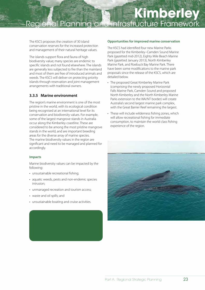
KimberleyRegional Planning and Infrastructure Framework
23Part A: Regional Strategic Planning
The KSCS proposes the creation of 30 island conservation reserves for the increased protection and management of their natural heritage values.
The islands support flora and fauna of high biodiversity value; many species are endemic to specific islands and not found elsewhere. The islands are generally less subjected to fire than the mainland and most of them are free of introduced animals and weeds. The KSCS will deliver on protecting priority islands through reservation and joint management arrangements with traditional owners.
3.3.5 Marine environment
The region’s marine environment is one of the most pristine in the world, with its ecological condition being recognised at an international level for its conservation and biodiversity values. For example, some of the largest mangrove stands in Australia occur along the Kimberley coastline. These are considered to be among the most pristine mangrove stands in the world, and are important breeding areas for the diverse array of marine species. The marine biodiversity values in the region are significant and need to be managed and planned for accordingly.
Impacts
Marine biodiversity values can be impacted by the following:
• unsustainable recreational fishing;
• aquatic weeds, pests and non-endemic species intrusion;
• unmanaged recreation and tourism access;
• waste and oil spills; and
• unsustainable boating and cruise activities.
Opportunities for improved marine conservation
The KSCS had identified four new Marine Parks proposed for the Kimberley–Camden Sound Marine Park (gazetted mid-2012), Eighty Mile Beach Marine Park (gazetted January 2013), North Kimberley Marine Park, and Roebuck Bay Marine Park. There have been some modifications to the marine park proposals since the release of the KSCS, which are detailed below.
• The proposed Great Kimberley Marine Park (comprising the newly proposed Horizontal Falls Marine Park, Camden Sound and proposed North Kimberley and the North Kimberley Marine Parks extension to the WA/NT border) will create Australia’s second largest marine park complex, with the Great Barrier Reef remaining the largest.
• These will include wilderness fishing zones, which will allow recreational fishing for immediate consumption, to maintain the world class fishing experience of the region.
The following opportunity has been identified for the marine environment:
• protect the region’s diverse and sensitive coastal attributes, including the marine environment.
KimberleyRegional Planning and Infrastructure Framework
24 Part A: Regional Strategic Planning
• There is also provision for parks to include sanctuary zones, which will exclude recreational and commercial fishing and other extractive activities, to protect the highly significant marine habitats and biodiversity.
Horizontal Falls Marine Park was proposed as a Class ‘A’ marine and national park in January 2013. The marine park proposal covers nearly 3,000 square kilometres to the south of Camden Sound, including Talbot, Collier, Doubtful Bays and Walcott Inlet. It will contribute to the proposed Great Kimberley Marine Park, which will expand to 26,000km2 (from Horizontal Falls to the WA/NT border).
3.3.6 Adequacy of environmental data and collaboration
Information on biodiversity, vegetation and water resource characteristics have not been collected or mapped at an appropriate scale to accurately inform planning and management decision-making.
The limited data availability and scientific understanding of the region’s environment has been largely due to the region’s remoteness and hence high cost of research. As a result most research has been exploratory and descriptive in approach.
The following opportunities have been identified to improve the adequacy of environmental data:
• appropriate information and knowledge about the region’s natural environment, especially around existing centres and other developable areas, to enable informed decision-making; and
• effective collaborations and information sharing between the scientific community, government and agencies in regard to environmental protection, management and assessment processes.
Opportunities for improved environmental data and collaboration
During the development and release of the KSCS, the following research priorities were identified to assist in obtaining scientific knowledge and accurate data sets:
• research on marine systems and values;
• more detailed vegetation mapping at different scales;
• continued support of biological surveys of important taxa and ecological communities;
• continued ongoing monitoring to assess changes in biodiversity;
• cultural heritage;
• social research to inform and plan for tourism opportunities;
• climate change impacts; and
• climate change mitigation and adaptation strategies for the region.
The establishment of baseline data and control sites for monitoring are essential for measuring environmental change over time. The research undertaken by the WA Marine Science Institute, the development of Environmental Data Library and Coastal vulnerability mapping, and the monitoring and evaluation Framework established for the North Kimberley as part of the Landscape Conservation Initiative is an example of this. Establishment of baseline data and monitoring will greatly assist in making informed planning and management decisions.
Collaboration between the scientific community, government and industry is essential for data research, data collection and sharing. Land use planning decisions will be accurately informed through improved collaboration and data sharing. An adaptive management approach for the region will link research and management programs to build on knowledge and data, as it becomes available.
KimberleyRegional Planning and Infrastructure Framework
25Part A: Regional Strategic Planning
The following opportunity has been identified to incorporate Aboriginal knowledge in land use planning:
• the inclusion of Indigenous Knowledge Systems in land use planning as information sources for environmental data and attributes.
3.3.7 Aboriginal knowledge and land use and development
Traditionally, Aboriginal knowledge about the natural (and cultural) environment has been passed on through storytelling, which has made it difficult for western science to understand or incorporate this information into decision-making.
The goals of the IPAs are to support:
• Aboriginal land owners to develop, declare and manage these areas as part of Australia’s National Reserve System;
• Aboriginal interests to develop cooperative management arrangements with Government agencies managing protected areas (joint management); and
• the integration of Aboriginal ecological and cultural knowledge with contemporary protected area management practices.
The Kimberley Ranger Program assists in the use and integration of Aboriginal ecological and cultural knowledge of the region. The work plans are guided by elders, and the traditional knowledge (i.e. how to care for country) is passed from generation to generation. The combination of cultural and traditional knowledge and western technologies is used to develop these work plans. Examples of tasks that rangers undertake in the Kimberley are; the protection of cultural sites, weeding, wildlife and biodiversity monitoring, burning, conducting research, monitoring the health of rivers and waterways and fish sampling. This knowledge and information can assist in the decision-making process.
Joint Management Agreements
In addition to IPA’s, the CALM Act 1984 was amended in March 2012 to provide greater opportunity for the joint management of land. Joint management is a cooperative, legal arrangement between the Western Australian Government (represented by DPAW) and one or more other parties to manage land or waters in Western Australia based on recognition, mutual respect and goals.
Joint management of lands where the CALM Act 1984 wouldn’t normally apply allows DPAW to enter into arrangements with Aboriginal people, private landowners, the Minister for Lands, a lessee (including pastoral lessees), local shires or a vested body or a body with the care, control and management of an area.
Opportunities to retain and utilise traditional Aboriginal knowledge
Indigenous Protected Areas (IPAs) are an initiative that supports Traditional Owner aspirations to protect cultural and natural assets for future generations. Their management utilises both traditional and western scientific knowledge to achieve the best outcomes for the environment and the community. IPAs do not restrain land tenure; rather they are a management tool for environmental, cultural and economic benefits of such areas of land.
Management practices include weed and feral animal control, fire management, revegetation, wildlife monitoring and protection.
In terms of land use planning, the IPA management plans should be taken into account as part of the decision making process, similar to coastal, wetland, flora and fauna, traffic and noise management plans. The information presented in the IPA management plans, can assist in the integration of Aboriginal knowledge within land use planning.
The program provides opportunities to incorporate additional information that is presented in the IPA management plans to inform the decision making process.
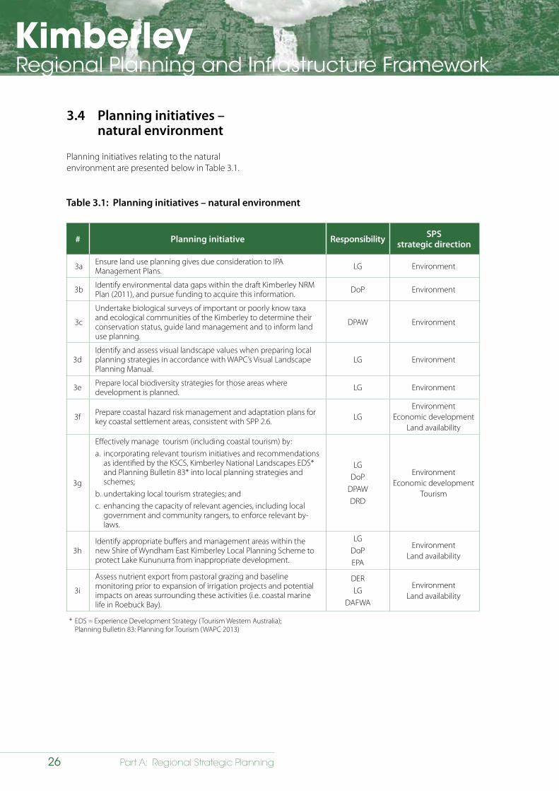
KimberleyRegional Planning and Infrastructure Framework
26 Part A: Regional Strategic Planning
Table 3.1: Planning initiatives – natural environment
# Planning initiative Responsibility SPSstrategic direction
3a Ensure land use planning gives due consideration to IPA Management Plans. LG Environment
3b Identify environmental data gaps within the draft Kimberley NRM Plan (2011), and pursue funding to acquire this information. DoP Environment
3c
Undertake biological surveys of important or poorly know taxa and ecological communities of the Kimberley to determine their conservation status, guide land management and to inform land use planning.
DPAW Environment
3dIdentify and assess visual landscape values when preparing local planning strategies in accordance with WAPC’s Visual Landscape Planning Manual.
LG Environment
3e Prepare local biodiversity strategies for those areas where development is planned. LG Environment
3f Prepare coastal hazard risk management and adaptation plans for key coastal settlement areas, consistent with SPP 2.6. LG
EnvironmentEconomic development
Land availability
3g
Effectively manage tourism (including coastal tourism) by:a. incorporating relevant tourism initiatives and recommendations
as identified by the KSCS, Kimberley National Landscapes EDS* and Planning Bulletin 83* into local planning strategies and schemes;
b. undertaking local tourism strategies; and c. enhancing the capacity of relevant agencies, including local
government and community rangers, to enforce relevant by-laws.
LGDoP
DPAWDRD
EnvironmentEconomic development
Tourism
3hIdentify appropriate buffers and management areas within the new Shire of Wyndham East Kimberley Local Planning Scheme to protect Lake Kununurra from inappropriate development.
LGDoPEPA
EnvironmentLand availability
3i
Assess nutrient export from pastoral grazing and baseline monitoring prior to expansion of irrigation projects and potential impacts on areas surrounding these activities (i.e. coastal marine life in Roebuck Bay).
DERLG
DAFWA
EnvironmentLand availability
* EDS = Experience Development Strategy (Tourism Western Australia); Planning Bulletin 83: Planning for Tourism (WAPC 2013)
3.4 Planning initiatives – natural environment
Planning initiatives relating to the natural environment are presented below in Table 3.1.
KimberleyRegional Planning and Infrastructure Framework
27Part A: Regional Strategic Planning
4 Settlement
4.1 Strategic direction
4.1.1 Overview
Over the next 25 years, the scale and character of the Kimberley’s settlements will need to change in order to accommodate anticipated growth. Of the region’s existing settlements some are likely to experience significant expansion while others can expect more modest rates of growth (refer to Map 4.1). It is important that the future functions of settlements are identified to ensure growth is managed effectively.
By 2036, it is anticipated that the Kimberley’s settlements will have:
• higher rates of dwelling owner-occupation;
• lower turnover rates in respect to residential occupation;
• higher secondary school retention rates; and
• higher rates of volunteering for community and associated activities.
4.1.2 Goal statement
To create sustainable settlements for communities that are safe, healthy, culturally diverse and enjoyable places to live and work; and offer a wide range of employment, cultural, educational and recreational opportunities.
4.1.3 State Planning Strategy
The State Planning Strategy has defined a series of objectives that relate to future planning of settlements in the Kimberley region:
• Spaces and places – creating places and spaces that foster culture, liveability, enterprise and identity.
• Affordable living – ensuring affordable living through housing diversity and compact settlements.
• Land availability – ensuring the sustainable supply of land for future development.
• Remote settlements – maintaining economic and community development through improved connectivity and cultural support.
4.2 Issues relating to population/settlement
The key issues relating to population/settlement in the Kimberley are:
• future population growth in the Kimberley region is expected to be above the State average and so needs to be accommodated;
• temporary population movements can be substantial at particular times of the year and these are not adequately measured;
• Aboriginal population data is not reflective of the actual situation;
• population drift can be an issue due to the ongoing changes to the viability of Aboriginal settlements/communities;
• population growth will require careful planning for settlement expansion and an appropriate supply of project-ready land;
• there is an inadequate supply of project-ready residential, commercial and industrial land in some of the region’s urban places to facilitate growth, due to factors including:
- resolution of land tenure matters;
- insufficient infrastructure capacity;
- inappropriate zoning and lack of structure planning;
- land capability;
- environmental constraints; and
- heritage constraints.
• areas to accommodate transient workforces (FIFO and seasonal) have not been identified within the region’s urban areas;
• development needs to be more climate responsive, water sensitive and energy efficient;
• large-scale resource projects will place significant pressure on some of the region’s urban areas;
• there is a lack of housing choice and limited availability of culturally sensitive housing in the region’s urban places;
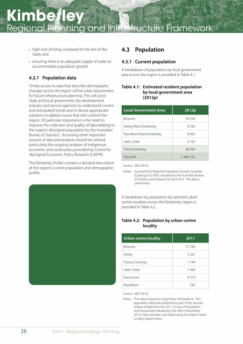
KimberleyRegional Planning and Infrastructure Framework
28 Part A: Regional Strategic Planning
• high cost of living compared to the rest of the State; and
• ensuring there is an adequate supply of water to accommodate population growth.
4.2.1 Population data
Timely access to data that describe demographic changes across the region will be a key requirement for future infrastructure planning. This will assist State and local government, the development industry and service agencies to understand current and anticipated trends and to devise appropriate solutions to address issues that will confront the region. Of particular importance is the need to improve the collection and quality of data relating to the region’s Aboriginal population by the Australian Bureau of Statistics. Accessing other important sources of data and analyses should be utilised, particularly the ongoing analyses of indigenous economic and social policy provided by Centre for Aboriginal Economic Policy Research (CAEPR).
The Kimberley Profile contains a detailed description of the region’s current population and demographic profile.
The following opportunities have been identified to improve population data:
• improving the accuracy of data describing the Aboriginal population;
• utilising accurate Aboriginal population data to guide land use and infrastructure planning and service provision;
• understanding of the impact of population drift on destination communities;
• investigating and understanding the full range of impacts attributable to proposed large-scale resource projects on local communities during the project planning phase; and
• management of the impacts of temporary population movements in susceptible urban places through implementation of flexible strategies.
4.3 Population
4.3.1 Current population
A breakdown of population by local government area across the region is provided in Table 4.1.
Table 4.1: Estimated resident population by local government area (2012p)
Local Government Area 2012p
Broome 16 524
Derby/West Kimberley 9 556
Wyndham/East Kimberley 8 665
Halls Creek 4 105
Total Kimberley 38 850
Total WA 2 469 102
Source: ABS (2013)
Notes: Sourced from Regional Population Growth, Australia (Catalogue 3218.0) complied by the Australian Bureau of Statistics and released 30 April 2013. The data is ‘preliminary’.
A breakdown by population by selected urban centre localities across the Kimberley region is provided in Table 4.2.
Table 4.2: Population by urban centre locality
Urban centre locality 2011
Broome 12 766
Derby 3 261
Fitzroy Crossing 1 144
Halls Creek 1 443
Kununurra 4 573
Wyndham 787
Source: ABS (2012)
Notes: This data is based on Usual Place of Residence. This population data was published as part of the second release of data from the 2011 Census of Population and Households (released by the ABS in November 2012). Data has been calculated using the Urban Centre Locality spatial extent.
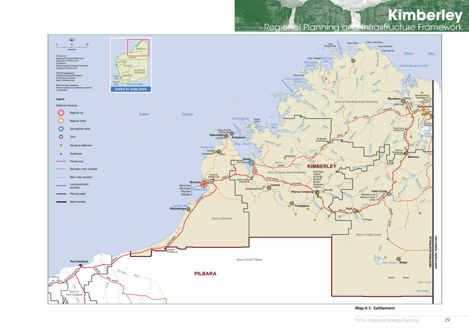
Part A: Regional Strategy Planning
KimberleyRegional Planning and Infrastructure Framework
Settlement
Kimberley Regional Planning and Infrastructure Framework
Map 4.1
!!
!!
!!
!!
!!
!!
!!
!!
!!
!!
!!
!!
!!
!!
!!
!!
!!!!!!
!!
!!
!!
!!
!!
!!
!! !!
!!
!!
!!
!!
!!
!!
!!
!!
!!
!!
!!
!!
!!
!!
!!
!!
!!
!!
!!
!!!!!!
!!
!!!!
!!!!
!!
!!!!
!!
!!!!!!
!!
!! !!
!!
!!
!!!!
!!!! !!!!
!!
!!!!!! !!
!!
!!!!!!
!!
!!
!!
!!
!!
!!
WickhamCOASTAL
WEST
HIGHW
AY
GREAT
NO
RTH
ER
N
HIGHWAY
ROAD
MARBLE
Yule
River
Shaw De GreyRiver
River
Roebuck Bay
Lagrange Bay
King SoundBeagle Bay
Cape Leveque
Yampi Sound
Sunday Strait
CollierBay
Brunswick Bay
Prince FrederickHarbour
Montague Sound
AdmiralityGulf
Vansittart Bay
Cape TalbotCapeBougainville
Cape Voltaire
Cape Pond
Cape Londonderry
Cape Rulhieres
Cape Bernier
Cam
brid
geG
ulf
Joseph Bonaparte Gulf
LakeArgyle
Tanami Desert
Lake Gregory
Lake Lucas
Lake White
Broome
Derby
Wyndham
Kununurra
Fitzroy Crossing Halls Creek
BAR
NORTH
Port Hedland
ROAD
GREAT
HIGHWAY
NORTHERN
GREAT
NORTHERN
HIGH
WAY
GIBB
RIVER
HWY
TANAM
IR
OA
D
ROAD
GIBB
WYNDHAMROAD
HW
Y
GREAT
NORTHERN
HWY
River
Riv
er
Lennard
River
Christmas
King
Riv
er
River
Edw
ard
King
Prince Regent
River
River
Gibb Rive
r
River River
Riv
er
RiverRiver
Ord
River
Riv
er
River
Fitzroy
Calder
Bidyadanga
Muludja
Rive
r
Bow
NORTHERN
BROOME
DER
BY DERBY
VICTORIA
Warmun
Balgo
Yungngora
Looma
ArdyaloonDjaraindjin
Yiyili
KoolanIsland
RIVER
DER
BY
Dur
ack
River
Hann
Riv
er
River
River
O'Donnell
Chapm
an
Cham
berla
in
River
River
Riv
er
Riv
er
Charnley
Barker
Nicholson
Berkeley
Leopold
Forrest
Elvire
Geo
rge
Robinson
River
River
RiverMoran
Panton
River
Fitzroy
Drysdale
River
Ord
River
Creek
Creek
Isdell
Rive
r
River
River
Mitchell
Wils
on
Car
son
Margaret
Stur
t
Karmulinunga
Windjingare
Jarlmadangah Burru
Lombadina
Mardiwah Loop
Budgarjook
Guda Guda
Nicholson Camp
Warrayu
Burawa
Nillir Irbanjin
Gumbarnum
Darlgunaya
Four Mile
Gulgagulganeng
Billard
Loanbun
Kurinyjarn
Burrguk
Morrell Park
BilgungurrMallingbar
MirimaNulleywah
Woolergerberleng
Gulberang
Lundja
Mindi RardiJunjuwaKurnangkiBungardi
Shire of East Pilbara
Indian Ocean
Legend
Local governmentboundary
Primary road
Aboriginal settlement
Timor Sea
WES
TER
N A
UST
RA
LIA
NO
RTH
ERN
TER
RIT
OR
Y
KIMBERLEY
PILBARA
Town of Port Hedland
Shire of Broome
Shire of Derby-West Kimberley
Shire of Wyndham-East Kimberley
Shire of Halls Creek
Planning region
State boundary
Roadhouse#
Willare BridgeRoadhouse
#
Mt BarnettRoadhouse#
#Warmun
Roadhouse
Doon DoonRoadhouse#
RoebuckRoadhouse
#
# SandfireRoadhouse
!!
Secondary road; unsealed
Minor road; unsealed
0 50 100
kilometres
N
Produced by:Mapping & GeoSpatial Data BranchDepartment of Planning, WAOn behalf of:Western Australian Planning CommissionCopyright © February 2015
\\Nts-per\magsprojects\Kimberley\KimberleyPlanningAndInfrastructureFramework\Map4_1Settlement.mxd
Base information supplied by:Western Australian Land Information AuthorityLI 430-2009-6
Regional centre
Sub-regional centre
Town
Settlement hierarchy
Regional city
GREAT SOUTHERNSOUTH
WEST
Index to map area
PERTHPEEL
MID WEST
GOLDFIELDS-ESPERANCE
GASCOYNE
PILBARA
KIMBERLEY
WHEATBELT
Map 4.1: Settlement
29
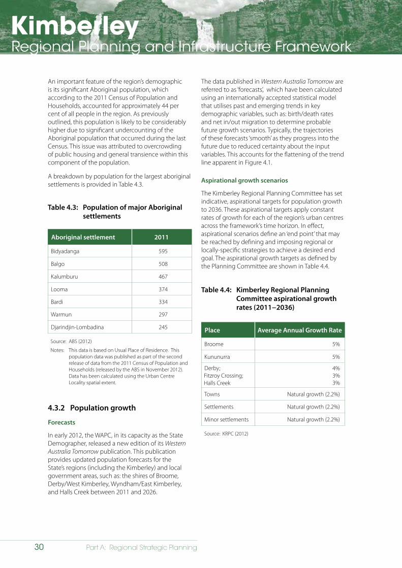
KimberleyRegional Planning and Infrastructure Framework
30 Part A: Regional Strategic Planning
An important feature of the region’s demographic is its significant Aboriginal population, which according to the 2011 Census of Population and Households, accounted for approximately 44 per cent of all people in the region. As previously outlined, this population is likely to be considerably higher due to significant undercounting of the Aboriginal population that occurred during the last Census. This issue was attributed to overcrowding of public housing and general transience within this component of the population.
A breakdown by population for the largest aboriginal settlements is provided in Table 4.3.
Table 4.3: Population of major Aboriginal settlements
Aboriginal settlement 2011
Bidyadanga 595
Balgo 508
Kalumburu 467
Looma 374
Bardi 334
Warmun 297
Djarindjin-Lombadina 245
Source: ABS (2012)
Notes: This data is based on Usual Place of Residence. This population data was published as part of the second release of data from the 2011 Census of Population and Households (released by the ABS in November 2012). Data has been calculated using the Urban Centre Locality spatial extent.
The data published in Western Australia Tomorrow are referred to as ‘forecasts’, which have been calculated using an internationally accepted statistical model that utilises past and emerging trends in key demographic variables, such as: birth/death rates and net in/out migration to determine probable future growth scenarios. Typically, the trajectories of these forecasts ‘smooth’ as they progress into the future due to reduced certainty about the input variables. This accounts for the flattening of the trend line apparent in Figure 4.1.
Aspirational growth scenarios
The Kimberley Regional Planning Committee has set indicative, aspirational targets for population growth to 2036. These aspirational targets apply constant rates of growth for each of the region’s urban centres across the framework’s time horizon. In effect, aspirational scenarios define an ‘end point’ that may be reached by defining and imposing regional or locally-specific strategies to achieve a desired end goal. The aspirational growth targets as defined by the Planning Committee are shown in Table 4.4.
Table 4.4: Kimberley Regional Planning Committee aspirational growth rates (2011−2036)
Place Average Annual Growth Rate
Broome 5%
Kununurra 5%
Derby; Fitzroy Crossing; Halls Creek
4%3%3%
Towns Natural growth (2.2%)
Settlements Natural growth (2.2%)
Minor settlements Natural growth (2.2%)
Source: KRPC (2012)
4.3.2 Population growth
Forecasts
In early 2012, the WAPC, in its capacity as the State Demographer, released a new edition of its Western Australia Tomorrow publication. This publication provides updated population forecasts for the State’s regions (including the Kimberley) and local government areas, such as: the shires of Broome, Derby/West Kimberley, Wyndham/East Kimberley, and Halls Creek between 2011 and 2026.
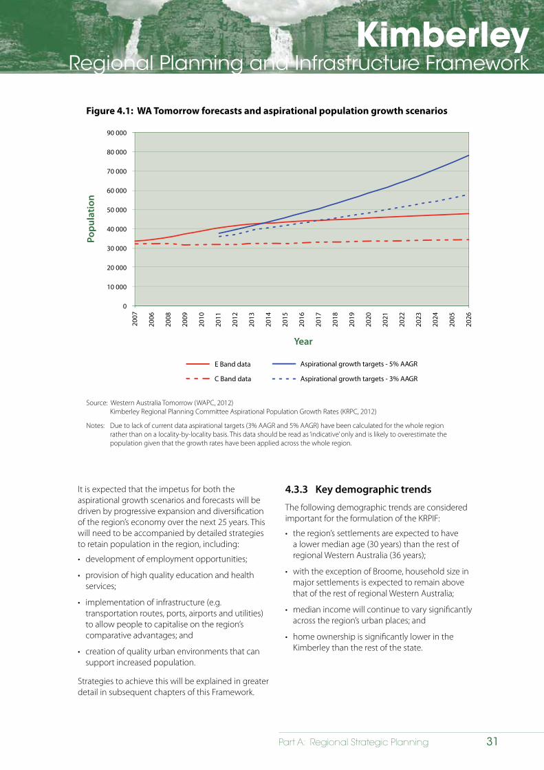
KimberleyRegional Planning and Infrastructure Framework
31Part A: Regional Strategic Planning
Figure 4.1: WA Tomorrow forecasts and aspirational population growth scenarios
90 000
80 000
70 000
60 000
50 000
40 000
30 000
20 000
10 000
0
Popu
latio
n
C Band data
200
7
2006
2008
2009
2010
2011
2012
2013
2014
2015
2016
2017
2018
2019
2020
2021
2022
2023
2024
2005
2026
Year
Aspirational growth targets - 3% AAGR
E Band data Aspirational growth targets - 5% AAGR
Source: Western Australia Tomorrow (WAPC, 2012) Kimberley Regional Planning Committee Aspirational Population Growth Rates (KRPC, 2012)
Notes: Due to lack of current data aspirational targets (3% AAGR and 5% AAGR) have been calculated for the whole region rather than on a locality-by-locality basis. This data should be read as ‘indicative’ only and is likely to overestimate the population given that the growth rates have been applied across the whole region.
It is expected that the impetus for both the aspirational growth scenarios and forecasts will be driven by progressive expansion and diversification of the region’s economy over the next 25 years. This will need to be accompanied by detailed strategies to retain population in the region, including:
• development of employment opportunities;
• provision of high quality education and health services;
• implementation of infrastructure (e.g. transportation routes, ports, airports and utilities) to allow people to capitalise on the region’s comparative advantages; and
• creation of quality urban environments that can support increased population.
Strategies to achieve this will be explained in greater detail in subsequent chapters of this Framework.
4.3.3 Key demographic trends
The following demographic trends are considered important for the formulation of the KRPIF:
• the region’s settlements are expected to have a lower median age (30 years) than the rest of regional Western Australia (36 years);
• with the exception of Broome, household size in major settlements is expected to remain above that of the rest of regional Western Australia;
• median income will continue to vary significantly across the region’s urban places; and
• home ownership is significantly lower in the Kimberley than the rest of the state.
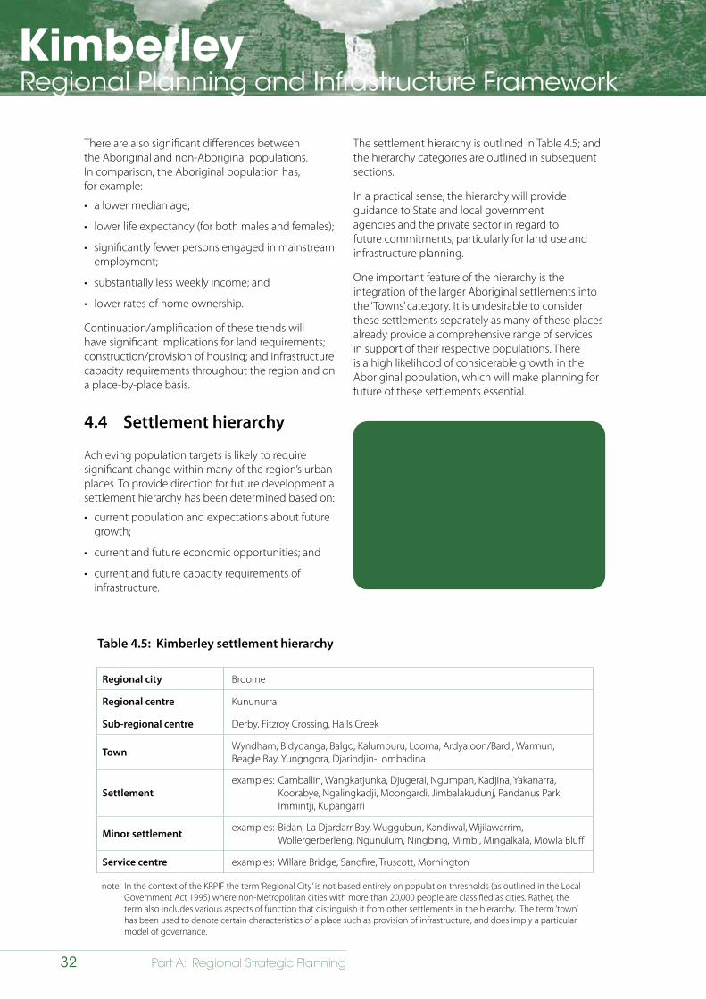
KimberleyRegional Planning and Infrastructure Framework
32 Part A: Regional Strategic Planning
There are also significant differences between the Aboriginal and non-Aboriginal populations. In comparison, the Aboriginal population has, for example:
• a lower median age;
• lower life expectancy (for both males and females);
• significantly fewer persons engaged in mainstream employment;
• substantially less weekly income; and
• lower rates of home ownership.
Continuation/amplification of these trends will have significant implications for land requirements; construction/provision of housing; and infrastructure capacity requirements throughout the region and on a place-by-place basis.
4.4 Settlement hierarchy
Achieving population targets is likely to require significant change within many of the region’s urban places. To provide direction for future development a settlement hierarchy has been determined based on:
• current population and expectations about future growth;
• current and future economic opportunities; and
• current and future capacity requirements of infrastructure.
Table 4.5: Kimberley settlement hierarchy
The settlement hierarchy is outlined in Table 4.5; and the hierarchy categories are outlined in subsequent sections.
In a practical sense, the hierarchy will provide guidance to State and local government agencies and the private sector in regard to future commitments, particularly for land use and infrastructure planning.
One important feature of the hierarchy is the integration of the larger Aboriginal settlements into the ‘Towns’ category. It is undesirable to consider these settlements separately as many of these places already provide a comprehensive range of services in support of their respective populations. There is a high likelihood of considerable growth in the Aboriginal population, which will make planning for future of these settlements essential.
The following opportunities have been identified in relation to future development of urban places:
• incorporation of major aboriginal settlements into mainstream planning; and
• ensuring that future population growth in the Kimberley is planned for and accommodated in accordance with a defined settlement hierarchy.
Regional city Broome
Regional centre Kununurra
Sub-regional centre Derby, Fitzroy Crossing, Halls Creek
Town Wyndham, Bidydanga, Balgo, Kalumburu, Looma, Ardyaloon/Bardi, Warmun, Beagle Bay, Yungngora, Djarindjin-Lombadina
Settlementexamples: Camballin, Wangkatjunka, Djugerai, Ngumpan, Kadjina, Yakanarra,
Koorabye, Ngalingkadji, Moongardi, Jimbalakudunj, Pandanus Park, Immintji, Kupangarri
Minor settlement examples: Bidan, La Djardarr Bay, Wuggubun, Kandiwal, Wijilawarrim, Wollergerberleng, Ngunulum, Ningbing, Mimbi, Mingalkala, Mowla Bluff
Service centre examples: Willare Bridge, Sandfire, Truscott, Mornington
note: In the context of the KRPIF the term ‘Regional City’ is not based entirely on population thresholds (as outlined in the Local Government Act 1995) where non-Metropolitan cities with more than 20,000 people are classified as cities. Rather, the term also includes various aspects of function that distinguish it from other settlements in the hierarchy. The term ‘town’ has been used to denote certain characteristics of a place such as provision of infrastructure, and does imply a particular model of governance.
KimberleyRegional Planning and Infrastructure Framework
33Part A: Regional Strategic Planning
4.5 Regional city
4.5.1 Regional city – characteristics
When compared to other settlements across the region a ‘Regional city’ can be described as a place that:
• accommodates the highest levels of current and predicted population growth;
• accommodates the highest levels of predicted economic growth;
• is serviced by regionally significant infrastructure and services, including: port facilities, regional health campus, private and public schools, tertiary education facilities, regional administrative offices of State agencies, focal point for transport corridors into and out of the region;
• is serviced by regional, district and local commercial and community activities; and
• has the highest current and future levels of predicted demand for housing and land (e.g. residential, commercial, industrial).
4.5.2 Regional city − Broome
Population growth
Broome is expected to accommodate the most significant amount of the region’s anticipated population growth over the next 25 years. In summary:
• the Shire of Broome accounts for 43 per cent of the region’s population (2011);
• the Broome townsite is the region’s most populous urban place (accounting for 87% of the LGA population in 2011);
• approximately 25 per cent of the population is Aboriginal;
• according to the highest population forecasts published in Western Australia Tomorrow, the Shire of Broome’s population is expected to be 27,700 by 2026;
• according to Kimberley Regional Planning Committee aspirational growth scenarios, a 5 per cent average annual growth rate (AAGR) would see Broome’s population increase to 44,395 by 2036 (Table 4.6 and Figure 4.2); and
• Broome supports significant regional infrastructure and is considered to be the service centre for the West Kimberley.
Table 4.6: Broome − aspirational population growth scenarios (2011−2036)
Year 2011 2016 2021 2026 2031 2036
3% 12 766 14 799 17 156 19 889 23 057 26 729
4% 12 766 15 532 18 897 22 991 27 972 34 032
5% 12 766 16 293 20 794 26 540 33 872 43 230
Source: KRPC (2012); ABS (2012)
Notes: Base population figures are those published as part of the second release of data from the 2011 Census of Population and Households (released by the ABS in November 2012). Data has been calculated using the Urban Centre Locality spatial extent.
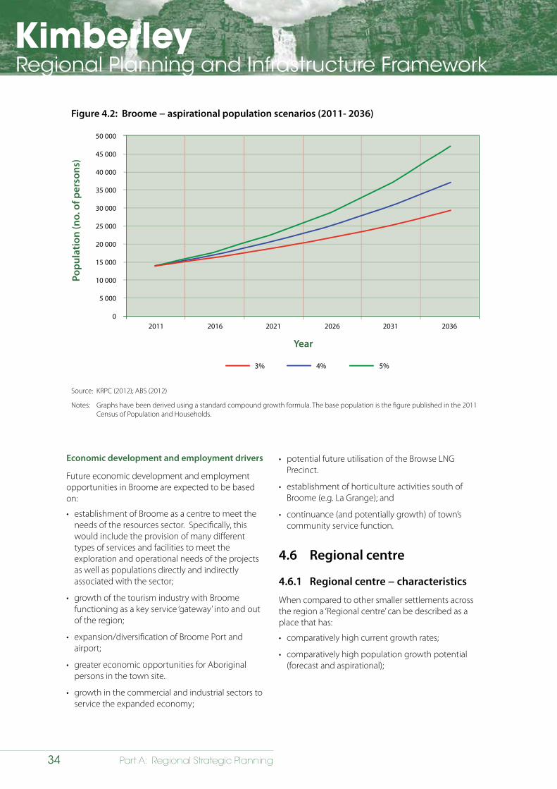
KimberleyRegional Planning and Infrastructure Framework
34 Part A: Regional Strategic Planning
Figure 4.2: Broome − aspirational population scenarios (2011- 2036)
2011 2016 2021 2026 2031 2036
50 000
45 000
40 000
35 000
30 000
25 000
20 000
15 000
10 000
5 000
0
Popu
latio
n (n
o. o
f per
sons
)
Year
4%3% 5%
Source: KRPC (2012); ABS (2012)
Notes: Graphs have been derived using a standard compound growth formula. The base population is the figure published in the 2011 Census of Population and Households.
Economic development and employment drivers
Future economic development and employment opportunities in Broome are expected to be based on:
• establishment of Broome as a centre to meet the needs of the resources sector. Specifically, this would include the provision of many different types of services and facilities to meet the exploration and operational needs of the projects as well as populations directly and indirectly associated with the sector;
• growth of the tourism industry with Broome functioning as a key service ‘gateway’ into and out of the region;
• expansion/diversification of Broome Port and airport;
• greater economic opportunities for Aboriginal persons in the town site.
• growth in the commercial and industrial sectors to service the expanded economy;
• potential future utilisation of the Browse LNG Precinct.
• establishment of horticulture activities south of Broome (e.g. La Grange); and
• continuance (and potentially growth) of town’s community service function.
4.6 Regional centre
4.6.1 Regional centre − characteristics
When compared to other smaller settlements across the region a ‘Regional centre’ can be described as a place that has:
• comparatively high current growth rates;
• comparatively high population growth potential (forecast and aspirational);
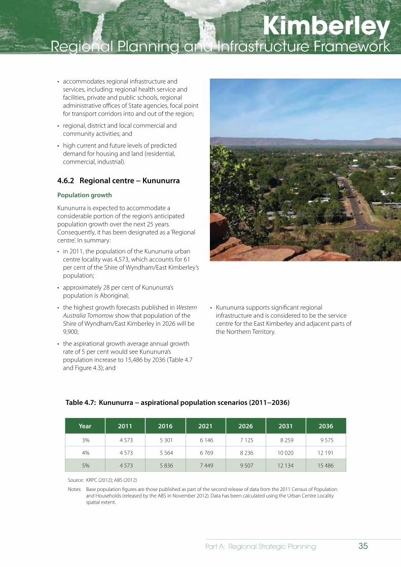
KimberleyRegional Planning and Infrastructure Framework
35Part A: Regional Strategic Planning
• accommodates regional infrastructure and services, including: regional health service and facilities, private and public schools, regional administrative offices of State agencies, focal point for transport corridors into and out of the region;
• regional, district and local commercial and community activities; and
• high current and future levels of predicted demand for housing and land (residential, commercial, industrial).
4.6.2 Regional centre − Kununurra
Population growth
Kununurra is expected to accommodate a considerable portion of the region’s anticipated population growth over the next 25 years. Consequently, it has been designated as a ‘Regional centre’. In summary:
• in 2011, the population of the Kununurra urban centre locality was 4,573, which accounts for 61 per cent of the Shire of Wyndham/East Kimberley’s population;
• approximately 28 per cent of Kununurra’s population is Aboriginal;
• the highest growth forecasts published in Western Australia Tomorrow show that population of the Shire of Wyndham/East Kimberley in 2026 will be 9,900;
• the aspirational growth average annual growth rate of 5 per cent would see Kununurra’s population increase to 15,486 by 2036 (Table 4.7 and Figure 4.3); and
Table 4.7: Kununurra − aspirational population scenarios (2011−2036)
Year 2011 2016 2021 2026 2031 2036
3% 4 573 5 301 6 146 7 125 8 259 9 575
4% 4 573 5 564 6 769 8 236 10 020 12 191
5% 4 573 5 836 7 449 9 507 12 134 15 486
Source: KRPC (2012); ABS (2012)
Notes: Base population figures are those published as part of the second release of data from the 2011 Census of Population and Households (released by the ABS in November 2012). Data has been calculated using the Urban Centre Locality spatial extent.
• Kununurra supports significant regional infrastructure and is considered to be the service centre for the East Kimberley and adjacent parts of the Northern Territory.
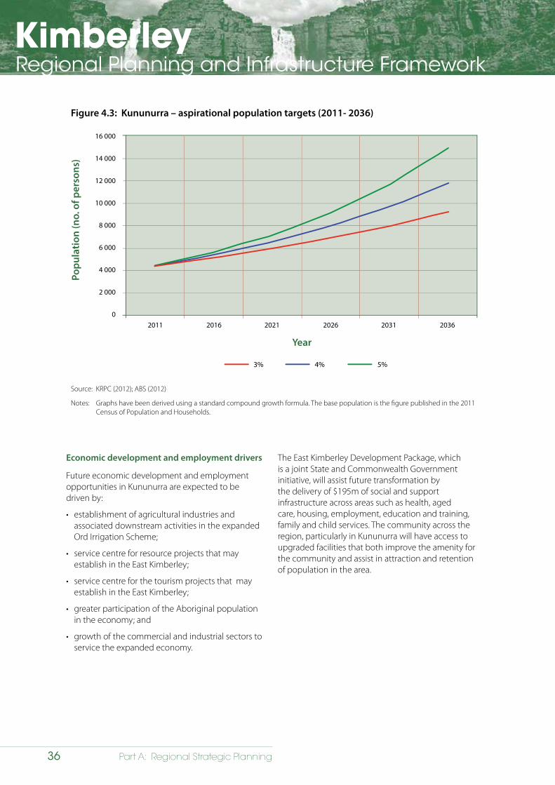
KimberleyRegional Planning and Infrastructure Framework
36 Part A: Regional Strategic Planning
Figure 4.3: Kununurra – aspirational population targets (2011- 2036)
2011 2016 2021 2026 2031 2036
16 000
14 000
12 000
10 000
8 000
6 000
4 000
2 000
0
Popu
latio
n (n
o. o
f per
sons
)
Year
4%3% 5%
Source: KRPC (2012); ABS (2012)
Notes: Graphs have been derived using a standard compound growth formula. The base population is the figure published in the 2011 Census of Population and Households.
Economic development and employment drivers
Future economic development and employment opportunities in Kununurra are expected to be driven by:
• establishment of agricultural industries and associated downstream activities in the expanded Ord Irrigation Scheme;
• service centre for resource projects that may establish in the East Kimberley;
• service centre for the tourism projects that may establish in the East Kimberley;
• greater participation of the Aboriginal population in the economy; and
• growth of the commercial and industrial sectors to service the expanded economy.
The East Kimberley Development Package, which is a joint State and Commonwealth Government initiative, will assist future transformation by the delivery of $195m of social and support infrastructure across areas such as health, aged care, housing, employment, education and training, family and child services. The community across the region, particularly in Kununurra will have access to upgraded facilities that both improve the amenity for the community and assist in attraction and retention of population in the area.
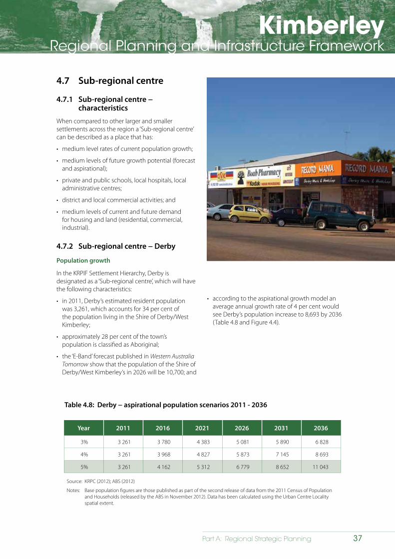
KimberleyRegional Planning and Infrastructure Framework
37Part A: Regional Strategic Planning
4.7 Sub-regional centre
4.7.1 Sub-regional centre − characteristics
When compared to other larger and smaller settlements across the region a ‘Sub-regional centre’ can be described as a place that has:
• medium level rates of current population growth;
• medium levels of future growth potential (forecast and aspirational);
• private and public schools, local hospitals, local administrative centres;
• district and local commercial activities; and
• medium levels of current and future demand for housing and land (residential, commercial, industrial).
4.7.2 Sub-regional centre − Derby
Population growth
In the KRPIF Settlement Hierarchy, Derby is designated as a ‘Sub-regional centre’, which will have the following characteristics:
• in 2011, Derby’s estimated resident population was 3,261, which accounts for 34 per cent of the population living in the Shire of Derby/West Kimberley;
• approximately 28 per cent of the town’s population is classified as Aboriginal;
• the ‘E-Band’ forecast published in Western Australia Tomorrow show that the population of the Shire of Derby/West Kimberley’s in 2026 will be 10,700; and
Table 4.8: Derby − aspirational population scenarios 2011 - 2036
Year 2011 2016 2021 2026 2031 2036
3% 3 261 3 780 4 383 5 081 5 890 6 828
4% 3 261 3 968 4 827 5 873 7 145 8 693
5% 3 261 4 162 5 312 6 779 8 652 11 043
Source: KRPC (2012); ABS (2012)
Notes: Base population figures are those published as part of the second release of data from the 2011 Census of Population and Households (released by the ABS in November 2012). Data has been calculated using the Urban Centre Locality spatial extent.
• according to the aspirational growth model an average annual growth rate of 4 per cent would see Derby’s population increase to 8,693 by 2036 (Table 4.8 and Figure 4.4).
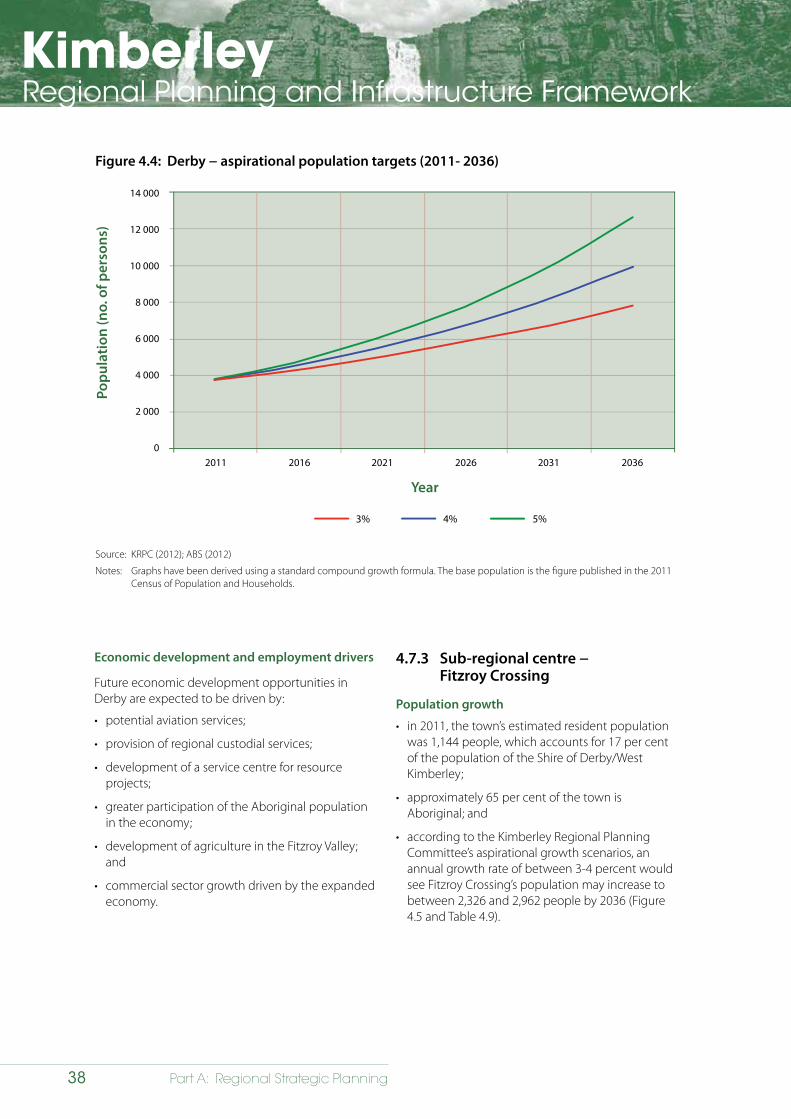
KimberleyRegional Planning and Infrastructure Framework
38 Part A: Regional Strategic Planning
Figure 4.4: Derby − aspirational population targets (2011- 2036)
2011 2016 2021 2026 2031 2036
14 000
12 000
10 000
8 000
6 000
4 000
2 000
0
Popu
latio
n (n
o. o
f per
sons
)
Year
4%3% 5%
Source: KRPC (2012); ABS (2012)
Notes: Graphs have been derived using a standard compound growth formula. The base population is the figure published in the 2011 Census of Population and Households.
Economic development and employment drivers
Future economic development opportunities in Derby are expected to be driven by:
• potential aviation services;
• provision of regional custodial services;
• development of a service centre for resource projects;
• greater participation of the Aboriginal population in the economy;
• development of agriculture in the Fitzroy Valley; and
• commercial sector growth driven by the expanded economy.
4.7.3 Sub-regional centre − Fitzroy Crossing
Population growth
• in 2011, the town’s estimated resident population was 1,144 people, which accounts for 17 per cent of the population of the Shire of Derby/West Kimberley;
• approximately 65 per cent of the town is Aboriginal; and
• according to the Kimberley Regional Planning Committee’s aspirational growth scenarios, an annual growth rate of between 3-4 percent would see Fitzroy Crossing’s population may increase to between 2,326 and 2,962 people by 2036 (Figure 4.5 and Table 4.9).
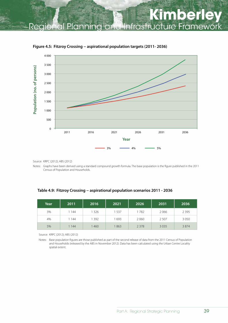
KimberleyRegional Planning and Infrastructure Framework
39Part A: Regional Strategic Planning
Figure 4.5: Fitzroy Crossing − aspirational population targets (2011- 2036)
4 000
3 500
3 000
2 500
2 000
1 500
1 000
500
0
Popu
latio
n (n
o. o
f per
sons
)
2011 2016 2021 2026 2031 2036
Year
4%3% 5%
Source: KRPC (2012); ABS (2012)
Notes: Graphs have been derived using a standard compound growth formula. The base population is the figure published in the 2011 Census of Population and Households.
Table 4.9: Fitzroy Crossing − aspirational population scenarios 2011 - 2036
Year 2011 2016 2021 2026 2031 2036
3% 1 144 1 326 1 537 1 782 2 066 2 395
4% 1 144 1 392 1 693 2 060 2 507 3 050
5% 1 144 1 460 1 863 2 378 3 035 3 874
Source: KRPC (2012); ABS (2012)
Notes: Base population figures are those published as part of the second release of data from the 2011 Census of Population and Households (released by the ABS in November 2012). Data has been calculated using the Urban Centre Locality spatial extent.
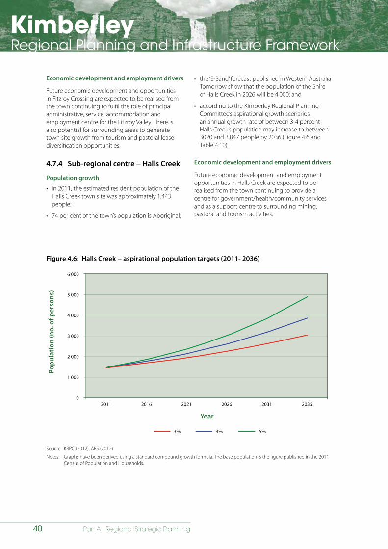
KimberleyRegional Planning and Infrastructure Framework
40 Part A: Regional Strategic Planning
Figure 4.6: Halls Creek − aspirational population targets (2011- 2036)
6 000
5 000
4 000
3 000
2 000
1 000
0
Popu
latio
n (n
o. o
f per
sons
)
2011 2016 2021 2026 2031 2036
Year
4%3% 5%
Source: KRPC (2012); ABS (2012)
Notes: Graphs have been derived using a standard compound growth formula. The base population is the figure published in the 2011 Census of Population and Households.
Economic development and employment drivers
Future economic development and opportunities in Fitzroy Crossing are expected to be realised from the town continuing to fulfil the role of principal administrative, service, accommodation and employment centre for the Fitzroy Valley. There is also potential for surrounding areas to generate town site growth from tourism and pastoral lease diversification opportunities.
4.7.4 Sub-regional centre − Halls Creek
Population growth
• in 2011, the estimated resident population of the Halls Creek town site was approximately 1,443 people;
• 74 per cent of the town’s population is Aboriginal;
• the ‘E-Band’ forecast published in Western Australia Tomorrow show that the population of the Shire of Halls Creek in 2026 will be 4,000; and
• according to the Kimberley Regional Planning Committee’s aspirational growth scenarios, an annual growth rate of between 3-4 percent Halls Creek’s population may increase to between 3020 and 3,847 people by 2036 (Figure 4.6 and Table 4.10).
Economic development and employment drivers
Future economic development and employment opportunities in Halls Creek are expected to be realised from the town continuing to provide a centre for government/health/community services and as a support centre to surrounding mining, pastoral and tourism activities.
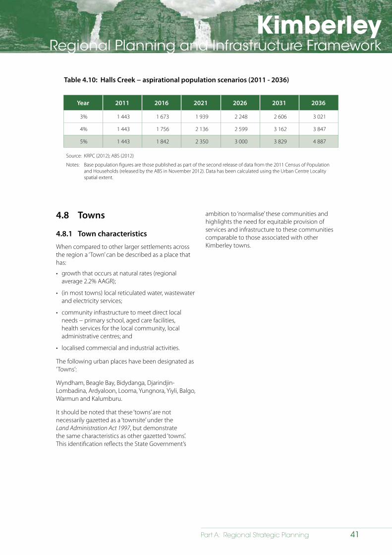
KimberleyRegional Planning and Infrastructure Framework
41Part A: Regional Strategic Planning
Table 4.10: Halls Creek − aspirational population scenarios (2011 - 2036)
Year 2011 2016 2021 2026 2031 2036
3% 1 443 1 673 1 939 2 248 2 606 3 021
4% 1 443 1 756 2 136 2 599 3 162 3 847
5% 1 443 1 842 2 350 3 000 3 829 4 887
Source: KRPC (2012); ABS (2012)
Notes: Base population figures are those published as part of the second release of data from the 2011 Census of Population and Households (released by the ABS in November 2012). Data has been calculated using the Urban Centre Locality spatial extent.
4.8 Towns
4.8.1 Town characteristics
When compared to other larger settlements across the region a ‘Town’ can be described as a place that has:
• growth that occurs at natural rates (regional average 2.2% AAGR);
• (in most towns) local reticulated water, wastewater and electricity services;
• community infrastructure to meet direct local needs − primary school, aged care facilities, health services for the local community, local administrative centres; and
• localised commercial and industrial activities.
The following urban places have been designated as ‘Towns’:
Wyndham, Beagle Bay, Bidydanga, Djarindjin-Lombadina, Ardyaloon, Looma, Yungnora, Yiyli, Balgo, Warmun and Kalumburu.
It should be noted that these ‘towns’ are not necessarily gazetted as a ‘townsite’ under the Land Administration Act 1997, but demonstrate the same characteristics as other gazetted ‘towns’. This identification reflects the State Government’s
ambition to ‘normalise’ these communities and highlights the need for equitable provision of services and infrastructure to these communities comparable to those associated with other Kimberley towns.
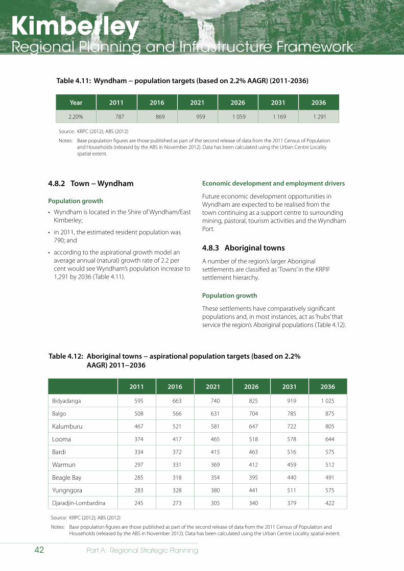
KimberleyRegional Planning and Infrastructure Framework
42 Part A: Regional Strategic Planning
4.8.2 Town − Wyndham
Population growth
• Wyndham is located in the Shire of Wyndham/East Kimberley;
• in 2011, the estimated resident population was 790; and
• according to the aspirational growth model an average annual (natural) growth rate of 2.2 per cent would see Wyndham’s population increase to 1,291 by 2036 (Table 4.11).
Table 4.11: Wyndham − population targets (based on 2.2% AAGR) (2011-2036)
Year 2011 2016 2021 2026 2031 2036
2.20% 787 869 959 1 059 1 169 1 291
Source: KRPC (2012); ABS (2012)
Notes: Base population figures are those published as part of the second release of data from the 2011 Census of Population and Households (released by the ABS in November 2012). Data has been calculated using the Urban Centre Locality spatial extent.
Economic development and employment drivers
Future economic development opportunities in Wyndham are expected to be realised from the town continuing as a support centre to surrounding mining, pastoral, tourism activities and the Wyndham Port.
4.8.3 Aboriginal towns
A number of the region’s larger Aboriginal settlements are classified as ‘Towns’ in the KRPIF settlement hierarchy.
Population growth
These settlements have comparatively significant populations and, in most instances, act as ‘hubs’ that service the region’s Aboriginal populations (Table 4.12).
Table 4.12: Aboriginal towns − aspirational population targets (based on 2.2% AAGR) 2011−2036
2011 2016 2021 2026 2031 2036
Bidyadanga 595 663 740 825 919 1 025
Balgo 508 566 631 704 785 875
Kalumburu 467 521 581 647 722 805
Looma 374 417 465 518 578 644
Bardi 334 372 415 463 516 575
Warmun 297 331 369 412 459 512
Beagle Bay 285 318 354 395 440 491
Yungngora 283 328 380 441 511 575
Djaradjin-Lombardina 245 273 305 340 379 422
Source: KRPC (2012); ABS (2012)
Notes: Base population figures are those published as part of the second release of data from the 2011 Census of Population and Households (released by the ABS in November 2012). Data has been calculated using the Urban Centre Locality spatial extent.
KimberleyRegional Planning and Infrastructure Framework
43Part A: Regional Strategic Planning
These settlements are serviced by self-contained utility infrastructure networks and provide some community services to their respective inhabitants. Housing within these places is provided by various programs that are funded to varying degrees by the Federal and State governments.
Economic development and employment drivers
At the present time, these towns support some economic development and employment opportunities although this may change in the future. As outlined in Section 5, identification of opportunities to promote growth in these settlements is seen as a key future growth strategy that will mean greater opportunities for the Aboriginal population.
4.9 Settlements
There are also many smaller settlements throughout the region. These consist primarily of:
• Aboriginal settlements (with populations of between 50 to 250 people)
• Aboriginal communities with populations below 50 persons), outstations and roadhouses.
4.10 Dwellings
Tight rental markets in some towns are significantly impacting on achieving regional development outcomes. There have been significant housing developments across the Kimberley in recent years, however, further increases are required in housing supply, to reduce high levels of overcrowding and place downward pressure on rents and housing prices. Given the emphasis that is being placed on facilitating ‘in migration’ throughout the Kimberley, particularly the realisation of greater economic opportunities, there may be potential to change the regional trend of comparatively low home ownership. This must, however, be supported by measures to:
• address the impacts of high house prices and income disparities on the ability of the population to access suitable housing by ensuring there is an adequate stock of affordable housing in the region’s urban places; and
• provide more short-stay accommodation of varying forms to meet demand from FIFO, seasonal workers and other types of transient population.
4.10.1 Resident population accommodation
New economic opportunities and strategies aimed at retaining population in the region will create significant ‘new’ demand for dwellings of varying forms and styles across the region. These impacts are likely to be most significant in larger urban places, such as Broome, Kununurra and Derby. There will also be a requirement to continue processes to provide appropriate housing to the service the needs of the region’s Aboriginal populations.
4.10.2 Transient / short-stay accommodation
Resource projects
Direct employees
Commitment to large-scale resource projects will create substantial demand for accommodation of various types. This will either be located onsite or integrated into existing communities that are in close proximity to project activities. Housing demand generated by resource projects relates to employees (persons specifically employed to work on a particular project) that are employed on a FIFO basis.
In many cases, resources sector employees will either acquire accommodation that is provided by a specific company or from the private sector in the form of:
• purpose-built accommodation to service FIFO workers, which is typified by many of the workers camps throughout the State − these are often comprised of living quarters, a mess and recreational facilities provided on-site; and
• available rental accommodation within a particular settlement.
There are emerging alternatives for accommodating employees engaged in the resources sector, including the provision of various types of dwellings in town sites to support Live In / Fly Out (LIFO). The LIFO work mode offers a number of key advantages particularly the fact that economic benefits from resource projects flow directly to local communities rather than to other places such as the place of worker origin (e.g. the Perth Metropolitan area).
KimberleyRegional Planning and Infrastructure Framework
44 Part A: Regional Strategic Planning
Consequential/indirect workers
Consequential/indirect workers (or those persons not directly employed by resource companies) will also require access to housing. It is unlikely; however, that these people will have access to housing that is provided directly by companies nor will they have access to location allowances that are often paid to workers. These ‘new’ populations will also place significant demand on existing housing stocks, services and infrastructure. Inadequate supply of housing coupled with rising rents and prices is likely to place pressure on other types of living spaces, particularly caravan parks and short-stay accommodation, which are crucial to meeting demands from other sectors like tourism.
Transient and seasonal workers
The issues of availability and affordability are further exacerbated for persons engaged in comparatively lower paid forms of employment such as seasonal employment in the tourism sector. At the present time, securing workforces requires employers to provide accommodation of varying standards such as dongas and rooms attached to commercial establishments. This trend looks set to continue, particularly in larger urban places that will be the focal points for these opportunities.
4.10.3 Public housing
The cost of housing across the region has tracked significantly upwards over the past 5−10 years due to:
• land supply shortages;
• servicing costs;
• cost of acquiring and transporting materials; and
• access to construction workforces.
This decrease in housing affordability has resulted in fewer opportunities for lower socio-economic groups to enter the housing market. Consequently, there is a significant requirement for supply and delivery of public housing across the region – the Kimberley has far higher numbers of persons living in public or community housing than across the State. In 2011, 45 per cent of non-Aboriginal people and only 12 per cent of Aboriginal people in the Kimberley owned their own home compared to the State average of 70.8 per cent.
Improving access to affordable housing options, particularly for lower socio-economic groups, has been the focus of initiatives like the Social Housing Taskforce and the State Housing Affordability Strategy. These investigations have outlined a number of key initiatives that can be directly applied to the Kimberley, including:
General
• introducing accommodation subsidies for apprentices and trainees;
• introducing suitable housing need assessment mechanisms; and
• providing greater opportunities for people in lower economic groups to become home owners.
Aboriginal housing
• articulating a vision for Aboriginal housing in urban and regional areas across Western Australia;
• continuing to assist Aboriginal families to access the private rental sector;
• assisting Aboriginal people to access home ownership options; and
• recognising the need to provide visitor accommodation in Halls Creek, Broome and Fitzroy Crossing.
The West Kimberley Revitalisation Plan, which commenced in 2013, allocated $33m towards an Aboriginal Housing Program.
Transitional housing
Transitional housing has been established in the East Kimberley and the Kimberley Development Commission is seeking to establish the model in the West Kimberley. It aims to move people through the housing continuum from public housing to the commercial housing market. This is a significant contemporary development that will impact future planning. The KDC has also established the Aboriginal Community Housing Project in Kununurra, Halls Creek and Fitzroy Crossing that represents further innovation of housing models for community benefit.
The 2015/16 State budget allocated $13.5 million to the West Kimberly Transitional Housing Program
4.11 Urban design
Creating settlements that people want to live in will be a key issue in retaining population in the region. In general, urban form is dictated by physical setting, climatic conditions and previous urban planning. Greening and shading towns is essential to creating attractive communities.
Each of the Kimberley’s urban places faces its own unique set of design challenges and opportunities. For example, future development in coastal towns (such as: Broome; Derby; and Kalumburu) will need to address
KimberleyRegional Planning and Infrastructure Framework
45Part A: Regional Strategic Planning
ocean frontages in a creative way while responding to the risks caused by storm surge and ocean inundation. When planning inland towns it will be important to take into account arid landscapes and risks from flash flooding and bushfires. In many cases, future development will need to retrofit some of the earlier urban structures to enhance liveability, walkability and assist with place-making. There is also a strong argument for the adoption of water sensitive design practices that utilise rainfall and ensure dwellings are designed to reduce heat and maximise cooling breezes.
Key urban design considerations include:
• creating well defined and cohesive settlements − setting and form;
• adopting water sensitive urban design practices;
• developing urban structures that are safe, in keeping with the character of the local landscape, permeable and engender connectivity;
• encouraging local variations between towns; and
• ensuring lot layout, landscaping and building design is climate responsive.
The following opportunities have been developed in relation to future land supply and dwellings:
• ensuring sufficient land is provided in urban places that are expected to experience growth;
• ensuring development constraints are known and addressed in a timely manner to ensure land can be released;
• providing sufficient land, accommodation and infrastructure in appropriate locations to accommodate workers in the resource, service, community development and tourism sectors within identified urban places;
• promoting and implementing strategies to ensure future development is based on high quality urban design, is climate responsive, water sensitive and energy efficient;
• providing greater choice, quantity, quality and affordability in housing provision;
• promoting dwelling/housing designs to cater for aboriginal occupants;
• promoting local population participation in emerging industries and ‘live in fly out’ opportunities;
• master planning to ensure towns develop in a structured manner and consider/allow for future population growth; and
• ensuring an affordable water supply is available to cater for additional people and land uses.
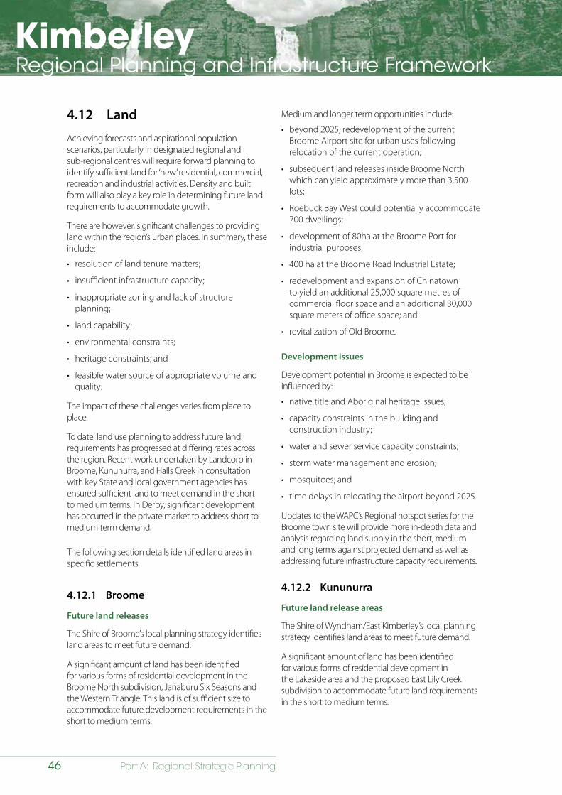
KimberleyRegional Planning and Infrastructure Framework
46 Part A: Regional Strategic Planning
4.12 Land
Achieving forecasts and aspirational population scenarios, particularly in designated regional and sub-regional centres will require forward planning to identify sufficient land for ‘new’ residential, commercial, recreation and industrial activities. Density and built form will also play a key role in determining future land requirements to accommodate growth.
There are however, significant challenges to providing land within the region’s urban places. In summary, these include:
• resolution of land tenure matters;
• insufficient infrastructure capacity;
• inappropriate zoning and lack of structure planning;
• land capability;
• environmental constraints;
• heritage constraints; and
• feasible water source of appropriate volume and quality.
The impact of these challenges varies from place to place.
To date, land use planning to address future land requirements has progressed at differing rates across the region. Recent work undertaken by Landcorp in Broome, Kununurra, and Halls Creek in consultation with key State and local government agencies has ensured sufficient land to meet demand in the short to medium terms. In Derby, significant development has occurred in the private market to address short to medium term demand.
The following section details identified land areas in specific settlements.
4.12.1 Broome
Future land releases
The Shire of Broome’s local planning strategy identifies land areas to meet future demand.
A significant amount of land has been identified for various forms of residential development in the Broome North subdivision, Janaburu Six Seasons and the Western Triangle. This land is of sufficient size to accommodate future development requirements in the short to medium terms.
Medium and longer term opportunities include:
• beyond 2025, redevelopment of the current Broome Airport site for urban uses following relocation of the current operation;
• subsequent land releases inside Broome North which can yield approximately more than 3,500 lots;
• Roebuck Bay West could potentially accommodate 700 dwellings;
• development of 80ha at the Broome Port for industrial purposes;
• 400 ha at the Broome Road Industrial Estate;
• redevelopment and expansion of Chinatown to yield an additional 25,000 square metres of commercial floor space and an additional 30,000 square meters of office space; and
• revitalization of Old Broome.
Development issues
Development potential in Broome is expected to be influenced by:
• native title and Aboriginal heritage issues;
• capacity constraints in the building and construction industry;
• water and sewer service capacity constraints;
• storm water management and erosion;
• mosquitoes; and
• time delays in relocating the airport beyond 2025.
Updates to the WAPC’s Regional hotspot series for the Broome town site will provide more in-depth data and analysis regarding land supply in the short, medium and long terms against projected demand as well as addressing future infrastructure capacity requirements.
4.12.2 Kununurra
Future land release areas
The Shire of Wyndham/East Kimberley’s local planning strategy identifies land areas to meet future demand.
A significant amount of land has been identified for various forms of residential development in the Lakeside area and the proposed East Lily Creek subdivision to accommodate future land requirements in the short to medium terms.
KimberleyRegional Planning and Infrastructure Framework
47Part A: Regional Strategic Planning
Longer-term opportunities include:
• development of Drovers Rest, which is located south of Lakeside − the site could potentially yield a further 2,500 lots in the longer term subject to finalisation of detailed planning to address site issues;
• the Lake Kununurra waterfront could yield land in the long-term but developing this site requires significant planning, including relocation of the existing bore field;
• development of an industrial area to service Ord Stage 2 and further expansion; and
• rural residential development will need to be accompanied by robust water supply planning.
Development issues
Development potential in Kununurra is expected to be influenced by:
• capacity constraints in the building and construction industry;
• wet season conditions limit the window of opportunity for civil works to be undertaken to the months of the dry season only;
• buffer issues and competition for land for rural-residential developments with priority agricultural land;
• managing the safety and efficiency of the regional road network to cater for increased travel demand and conflict between local and regional traffic, including heavy freight vehicles;
• drainage;
• proximity and impact of development on Lake Kununurra which is a listed wetland;
• expansion of the town is restricted by the airport and the bore fields; and
• a replacement drinking water source needs to be found, harnessed and brought on-line before the current bore field can be decommissioned.
Updates to the WAPC’s Regional Hotspot series for the Kununurra townsite will provide more in-depth data and analysis of land supply in the short, medium and long terms against projected demand as well as addressing future infrastructure capacity requirements.
4.12.3 Derby
Future land requirements
The Shire of Derby/West Kimberley’s local planning strategy identifies land areas to meet future demand for residential, commercial, tourism and mixed use activities.
Development issues
Development potential in Derby is expected to be influenced by:
• resolution of native title;
• capacity constraints in the building and construction industry;
• redevelopment of existing residential areas is constrained in some instances by a lack of infill sewerage;
• availability and quality of groundwater. Non-scheme supply and public open space supplies need to be carefully considered due to these risks; and
• the town is low-lying and located on a narrow peninsula so development is at risk of inundation from cyclonic storm surge.
Future updates to the WAPC’s Regional Hotspot series for the Derby town site will provide more in-depth data and analysis of land supply in the short, medium and long terms against projected demand as well as addressing future infrastructure capacity requirements.
4.12.4 Fitzroy Crossing
Future land release
The Fitzroy Futures Town Plan (WAPC, 2010) identifies future residential areas in Fitzroy Crossing, including the five communities. The rezoning and development of many of these sites would be subject to the successful completion of a consolidated land assembly strategy.
Development issues
Development potential in Fitzroy Crossing is expected to be influenced by:
• limited availability of land, with the town site being severely constrained by a 100-year flood level;
• water/waste water supply and capacity constraints;
• resolution of native title issues;

KimberleyRegional Planning and Infrastructure Framework
48 Part A: Regional Strategic Planning
• complex and anomalous land tenure arrangements, resulting in complex and lengthy land assembly processes;
• high development costs due to remoteness and difficult site conditions; and
• provision of services and accommodation options for temporary and seasonal visitors.
4.12.5 Halls Creek
Future land release
Landcorp has recently undertaken works to release residential lots as part of Stage 2 of the Bridge Street subdivision. The subdivision has been designed to include single, grouped and duplex lots. There is significant land to support subsequent land releases as demand dictates.
Development issues
Development potential in Halls Creek is expected to be influenced by:
• water source protection requirements and capacity constraints;
• high development costs due to remoteness;
• lack of private investors;
• the town site is surrounded by unallocated crown land which is subject to native title;
• many of the identified future development areas are subject to resolution of native title and are covered by exploration licences;
• unknown or changing demands for housing; and
• high occupancy rates within the Aboriginal population.
4.12.6 Wyndham
Future land development
The Shire of Wyndham/East Kimberley has identified potential land release areas in the Wyndham town site as part of preparing its local planning strategy. Requirements will be closely linked to further development of the Ord Irrigation Scheme and the potential expansion of the port facility in relation to this activity.
4.12.7 Aboriginal towns
Future land release
Layout plans that have been prepared for these settlements as part of SPP 3.2 – Aboriginal Settlements identify areas for future expansion. These layout plans, which are reviewed periodically for each of these settlements, are available on the WAPC website (www.planning.wa.gov.au).
4.13 Planning initiatives – settlement
Planning initiatives relating to settlement are presented in Table 4.13.
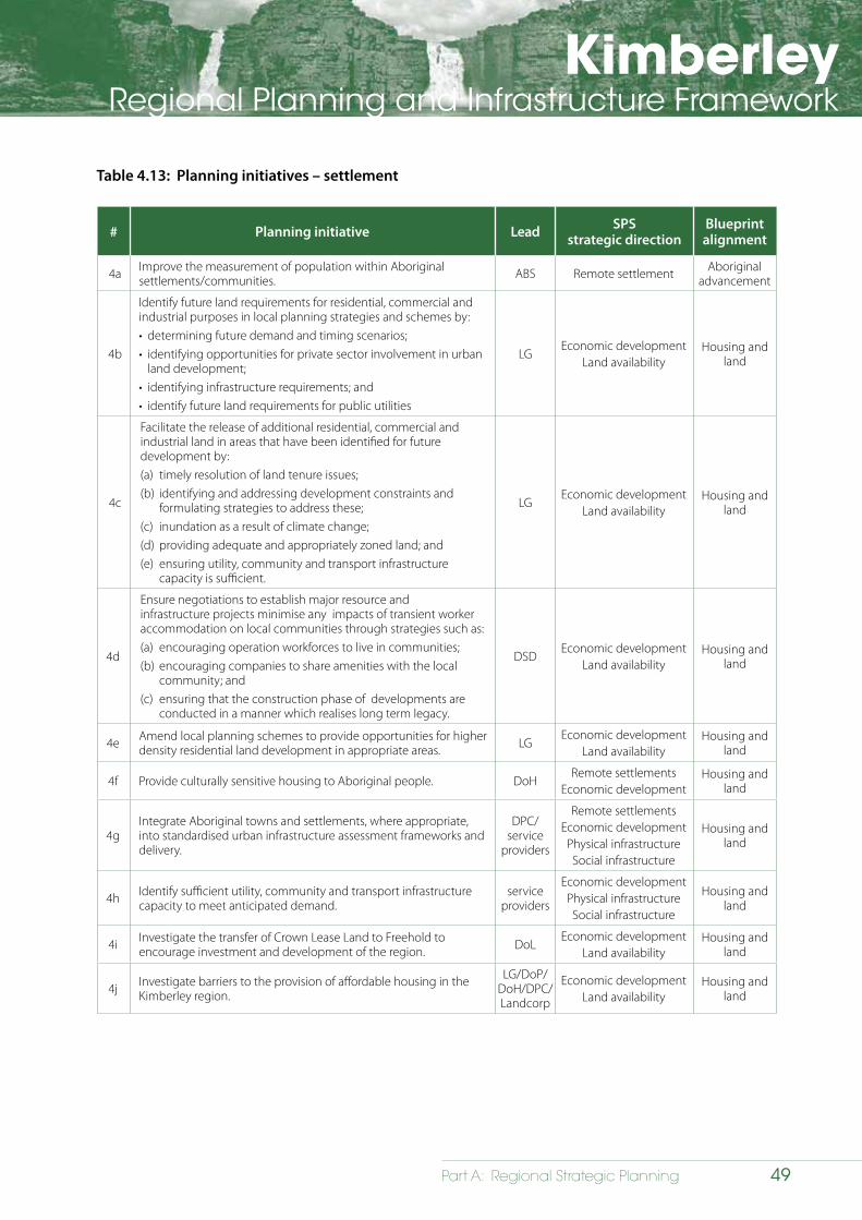
KimberleyRegional Planning and Infrastructure Framework
49Part A: Regional Strategic Planning
Table 4.13: Planning initiatives – settlement
# Planning initiative Lead SPSstrategic direction
Blueprintalignment
4a Improve the measurement of population within Aboriginal settlements/communities. ABS Remote settlement Aboriginal
advancement
4b
Identify future land requirements for residential, commercial and industrial purposes in local planning strategies and schemes by:• determining future demand and timing scenarios;• identifying opportunities for private sector involvement in urban
land development;• identifying infrastructure requirements; and• identify future land requirements for public utilities
LGEconomic development
Land availabilityHousing and
land
4c
Facilitate the release of additional residential, commercial and industrial land in areas that have been identified for future development by: (a) timely resolution of land tenure issues;(b) identifying and addressing development constraints and
formulating strategies to address these;(c) inundation as a result of climate change;(d) providing adequate and appropriately zoned land; and (e) ensuring utility, community and transport infrastructure
capacity is sufficient.
LGEconomic development
Land availabilityHousing and
land
4d
Ensure negotiations to establish major resource and infrastructure projects minimise any impacts of transient worker accommodation on local communities through strategies such as: (a) encouraging operation workforces to live in communities;(b) encouraging companies to share amenities with the local
community; and(c) ensuring that the construction phase of developments are
conducted in a manner which realises long term legacy.
DSDEconomic development
Land availabilityHousing and
land
4e Amend local planning schemes to provide opportunities for higher density residential land development in appropriate areas. LG
Economic developmentLand availability
Housing and land
4f Provide culturally sensitive housing to Aboriginal people. DoHRemote settlements
Economic developmentHousing and
land
4gIntegrate Aboriginal towns and settlements, where appropriate, into standardised urban infrastructure assessment frameworks and delivery.
DPC/service
providers
Remote settlementsEconomic development
Physical infrastructureSocial infrastructure
Housing and land
4h Identify sufficient utility, community and transport infrastructure capacity to meet anticipated demand.
service providers
Economic developmentPhysical infrastructureSocial infrastructure
Housing and land
4i Investigate the transfer of Crown Lease Land to Freehold to encourage investment and development of the region. DoL
Economic developmentLand availability
Housing and land
4j Investigate barriers to the provision of affordable housing in the Kimberley region.
LG/DoP/DoH/DPC/Landcorp
Economic developmentLand availability
Housing and land
KimberleyRegional Planning and Infrastructure Framework
50 Part A: Regional Strategic Planning
5 Economic development
5.1 Strategic direction
5.1.1 Overview
The Kimberley Regional Planning and Infrastructure Framework provides the impetus to transform the region’s economy over the next 25 years so that it becomes broader and more able to facilitate and support population growth. Achieving growth targets will require the formulation of economic development and employment strategies that aim to retain the region’s existing population while also providing opportunities to generate and sustain growth. The future economic strategy for the region will be based on maximising opportunities presented by:
• utilisation of the region’s pastoral leases for a wider range of economic activities;
• expansion and intensification of agriculture and horticulture;
• expansion of the tourism sector to capitalise on the region’s unique features;
• encouraging the development of the region’s mineral resources and oil and gas resources;
• capitalising on supply chain and logistics opportunities presented by committed and proposed offshore oil and gas developments and in other sectors;
• development of the region’s strategic industrial areas to provide opportunities for industry;
• identify options for innovation technologies relating to the resources sector;
• promote expansion of educational/university capability in partnership with industry.
• identifying ways to facilitate greater participation of the Aboriginal population in the economy;
• expansion of the region’s settlements;
• identifying and capitalising on new and emerging opportunities relevant to the region; and
• development of the Browse LNG Precinct.
Future economic growth will be underpinned by identifying and implementing opportunities for diversification. At present, the most likely options will be in the agricultural, pastoral, resources and tourism sectors (refer to Map 5.1). It will be critical, however, that any diversification strategies acknowledge and preserve the delicate balance between growth and protecting the region’s unique natural assets.
Economic growth can only be facilitated by locating a land use close to an appropriate water source and by providing sufficient ‘enabling’ infrastructure, including adequate power capacity; adequate transport facilities (roads, ports, airports); and sufficient land zoned and serviced for light industrial and commercial uses.
5.1.2 Goal statement
A robust, diversified and sustainable regional economy that will provide sufficient employment opportunities for the Kimberley’s planned population growth.
5.1.3 State Planning Strategy
The State Planning Strategy defines a series of objectives that relate specifically to future development and management of the State’s economy generally and, more specifically, on a region-by-region basis. The following key points are relevant to this chapter:
• Economic development – to facilitate coordinated and sustainable economic development.
• Food security – to enable the State’s food supply chain and projected demands of its domestic and global food market.
• Knowledge – for Western Australia to become globally competitive as a creative, innovative and knowledge-based economy.
• Tourism – to access and enhance a range of experiences unique to the State.
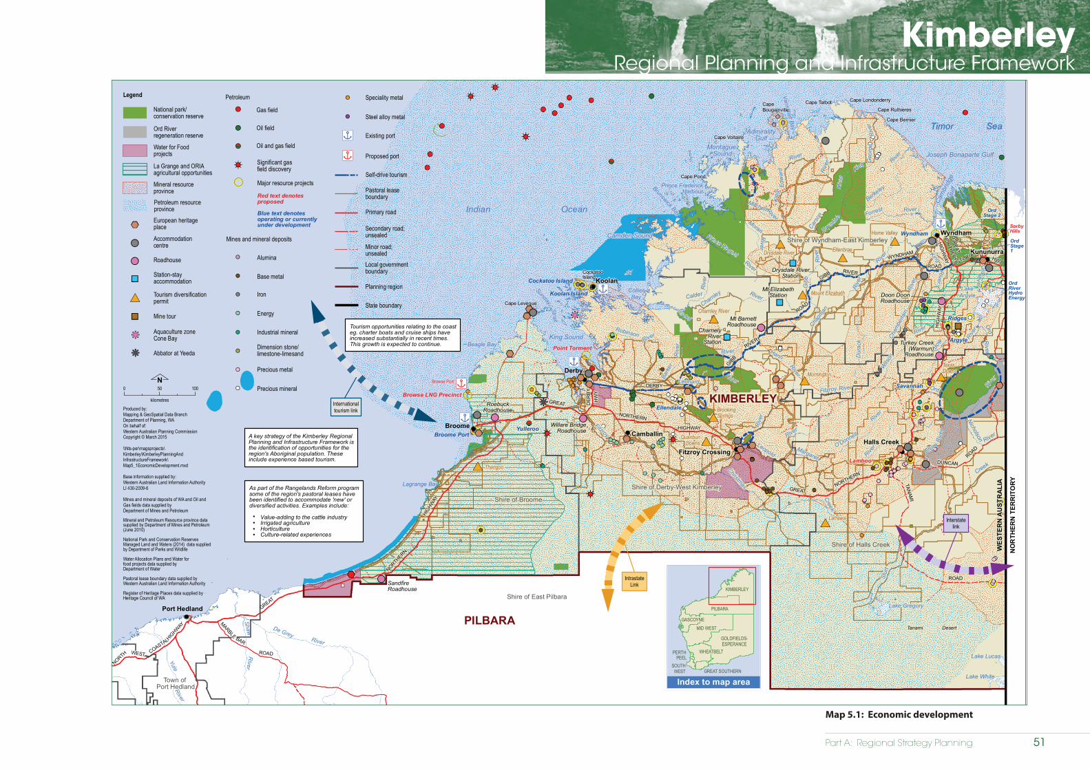
Part A: Regional Strategy Planning
KimberleyRegional Planning and Infrastructure Framework
Economic development
Kimberley Regional Planning and Infrastructure Framework
Map 5.1WO ROAD
Wickham
TREAMPANNANICA
COASTAL
WEST HIGHWAY
HIGHW
AY
GREAT
NO
RTH
ER
N
HIG
HWAY
ROAD
MARBLE
RO
AD
BAR
SPRINGSTelfer
River
Fortescue
River
Yule
River
Shaw
River
De GreyRiver
River
River
Swamp
Goodjadarnie
Anketell
Lagrange Bay
King SoundBeagle Bay
Cape Leveque
SundayStrait
CollierBay
Camden Sound
Brunswick Bay
Prince FrederickHarbour
Montague Sound
AdmiralityGulf
Vansittart Bay
Cape TalbotCapeBougainville
Cape Voltaire
Cape Pond
Cape Londonderry
Cape Rulhieres
Cape Bernier
Cam
brid
geG
ulf
Joseph Bonaparte Gulf
LakeArgyle
Tanami Desert
Lake Gregory
Lake Lucas
Lake White
Broome
Koolan
Derby
Wyndham
Kununurra
Fitzroy CrossingHalls Creek
Camballin
BAR
NORTH
GREAT
HIGHWAY
NORTHERN
GREATNORTHERN
HIG
HW
AY
GIBB
RIVER
HWY
TANAM
I
ROAD
DUNCANROAD
ROAD
GIBB
WYNDHAM
ROAD
HW
Y
GR
EAT
NORTHERN
HIG
HW
AYR
iver
River
Riv
er
LennardRiver
Christmas
King
Riv
er
River
Edw
ard
King
Prince Regent
River
River
Gib
b
Rive
r
River
Riv
er
RiverRiver
Ord
River
Riv
er
River
River
Fitzroy
Riv
er
¿
¿
¿
¿
¿¿
Internationaltourism link
IntrastateLink
Interstatelink
CockatooIsland
Port Hedland
SorbyHills
Browse Port
SKULL
NORTH
KarrathaRoebourne
Dampier
Nullagine
Point Samson
NORTHERN
DERBY
RIVER
VICTORIA
DER
BY
Dur
ack
River
Hann
Riv
er
River
River
O'Donnell
Chapm
an
Cham
berla
in
River
Riv
erR
iver
Calder
Charnley
Bark
er
Rive
r
Nicholson
Berkeley
Leopold
Forrest
Elvire
Geo
rge
King
Robinson
River
River
RiverMoran
River
Bow
Fitzroy
Drysdale
Ord
River
Ord River
Creek
Creek
Isdell
Riv
er
River
River
Mitchell
Wils
on
Cars
on
Margaret
Stur
t
As part of the Rangelands Reform programsome of the region's pastoral leases havebeen identified to accommodate 'new' ordiversified activities. Examples include:
Value-adding to the cattle industry Irrigated agriculture Horticulture Culture-related experiences
Tourism opportunities relating to the coasteg. charter boats and cruise ships haveincreased substantially in recent times.This growth is expected to continue.
A key strategy of the Kimberley Regional Planning and Infrastructure Framework isthe identification of opportunities for the region's Aboriginal population. Theseinclude experience based tourism.
!
!
!
!
Ridges
Broome Port
Argyle
Wyndham
Savannah
Ellendale
Koolan Island
Cockatoo Island
Yulleroo
Lamboo
Point Torment
Browse LNG Precinct
OrdRiverHydroEnergy
OrdStage1
OrdStage 2
kk
kk
Shire of East Pilbara
Indian Ocean
Timor Sea
WES
TER
N A
UST
RA
LIA
KIMBERLEY
PILBARA
Town of Port Hedland
Shire of Broome
Shire of Derby-West Kimberley
Shire of Wyndham-East Kimberley
Shire of Halls Creek
0 50 100
kilometres
N
Produced by:Mapping & GeoSpatial Data BranchDepartment of Planning, WAOn behalf of:Western Australian Planning CommissionCopyright © March 2015
\\Nts-per\magsprojects\Kimberley\KimberleyPlanningAndInfrastructureFramework\Map5_1EconomicDevelopment.mxd
Base information supplied by:Western Australian Land Information AuthorityLI 430-2009-6
Mines and mineral deposits of WA and Oil andGas fields data supplied byDepartment of Mines and Petroleum
KIMBERLEY
PILBARA
GOLDFIELDS-ESPERANCE
MID WESTGASCOYNE
WHEATBELT
GREAT SOUTHERNSOUTH
WEST
PERTHPEEL
Index to map area
Legend
National park/conservation reserve
Petroleum resource province
Mineral resource province
Red text denotesproposed
La Grange and ORIAagricultural opportunities
Blue text denotesoperating or currentlyunder development
Petroleum
Gas field
Oil field
Oil and gas field
Significant gasfield discovery
!!
!!
!<
<
Mineral and Petroleum Resource province data supplied by Department of Mines and Petroleum(June 2010)
National Park and Conservation ReservesManaged Land and Waters (2014) data suppliedby Department of Parks and Wildlife Water Allocation Plans and Water for food projects data supplied byDepartment of Water
Pastoral lease boundary data supplied by Western Australian Land Information Authority
Register of Heritage Places data supplied byHeritage Council of WA
European heritageplace%%
Accommodationcentre
Roadhouse
Station-stayaccommodation
!!
""
!!
#* Tourism diversificationpermit
Mine tour""
Timor Sea
NO
RTH
ERN
TER
RIT
OR
Y
RoebuckRoadhouse
!!Willare Bridge
Roadhouse
#
#
Turkey Creek(Warmun)
Roadhouse
SandfireRoadhouse
Mt BarnettRoadhouse
!!
!!
!!
!!
!!
%%
%%
%%%% %%
%%%%
%%%%%%
%%
%%
%%
%%%%%%
%%
%%
%%
!!
!!
!!
!!!!
!!
!!
!!
Doon DoonRoadhouse
""Charnely
RiverStation
""
Mt ElizabethStation
""Drysdale River
Station
""
!!
!!
!!
#*
#*#*
Drysdale River
#* Mount Elizabeth
#*Charnley River
#*Mornington
BrookingSprings
#*Quanbun
Downs
#*
#*TexasDowns
#*Larrawa
Thangoo#*
Home Valley
Ellenbrae
Pastoral lease boundary
Self-drive tourism
Existing port
Proposed portn|
n|
Local governmentboundary
Primary road
Secondary road; unsealed
Minor road; unsealed
Planning region
State boundary
Base metal
Alumina
Dimension stone/limestone-limesand
Energy
Industrial mineral
Iron
Precious metal
Major resource projects
Mines and mineral deposits
!!
!!
!!
!!
!!
!!
!! Speciality metal
Precious mineral
Steel alloy metal!!
!!
!!
'*
n|
n|
n|
n|
n|
kk
kk
Aquaculture zoneCone Bay
Abbator at Yeeda
Ord Riverregeneration reserve
Water for Foodprojects
Map 5.1: Economic development
51
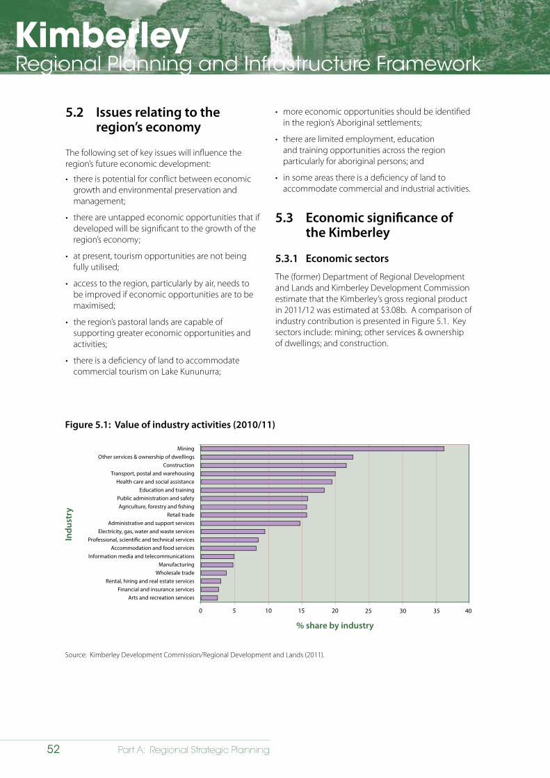
KimberleyRegional Planning and Infrastructure Framework
52 Part A: Regional Strategic Planning
5.2 Issues relating to the region’s economy
The following set of key issues will influence the region’s future economic development:
• there is potential for conflict between economic growth and environmental preservation and management;
• there are untapped economic opportunities that if developed will be significant to the growth of the region’s economy;
• at present, tourism opportunities are not being fully utilised;
• access to the region, particularly by air, needs to be improved if economic opportunities are to be maximised;
• the region’s pastoral lands are capable of supporting greater economic opportunities and activities;
• there is a deficiency of land to accommodate commercial tourism on Lake Kununurra;
Figure 5.1: Value of industry activities (2010/11)
MiningOther services & ownership of dwellings
ConstructionTransport, postal and warehousing
Health care and social assistanceEducation and training
Public administration and safetyAgriculture, forestry and �shing
Retail tradeAdministrative and support services
Electricity, gas, water and waste servicesProfessional, scienti�c and technical services
Accommodation and food servicesInformation media and telecommunications
ManufacturingWholesale trade
Rental, hiring and real estate servicesFinancial and insurance services
Arts and recreation services
0 5 10 15 20
% share by industry
25 30 35 40
Indu
stry
Source: Kimberley Development Commission/Regional Development and Lands (2011).
• more economic opportunities should be identified in the region’s Aboriginal settlements;
• there are limited employment, education and training opportunities across the region particularly for aboriginal persons; and
• in some areas there is a deficiency of land to accommodate commercial and industrial activities.
5.3 Economic significance of the Kimberley
5.3.1 Economic sectors
The (former) Department of Regional Development and Lands and Kimberley Development Commission estimate that the Kimberley’s gross regional product in 2011/12 was estimated at $3.08b. A comparison of industry contribution is presented in Figure 5.1. Key sectors include: mining; other services & ownership of dwellings; and construction.
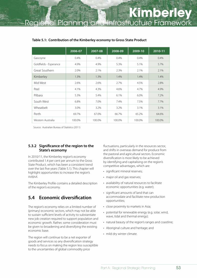
KimberleyRegional Planning and Infrastructure Framework
53Part A: Regional Strategic Planning
5.3.2 Significance of the region to the State’s economy
In 2010/11, the Kimberley region’s economy contributed 1.4 per cent per annum to the Gross State Product, which has been a consistent trend over the last five years (Table 5.1). This chapter will highlight opportunities to increase the region’s output.
The Kimberley Profile contains a detailed description of the region’s economy.
5.4 Economic diversification
The region’s economy relies on a limited number of (primary) economic sectors, which may not be able to sustain sufficient levels of activity to substantiate new job creation required to support population and economic growth. Rather, some consideration must be given to broadening and diversifying the existing economic base.
The region will continue to be a net exporter of goods and services so any diversification strategy needs to focus on making the region less susceptible to the uncertainties of global commodity price
2006-07 2007-08 2008-09 2009-10 2010-11
Gascoyne 0.4% 0.4% 0.4% 0.4% 0.4%
Goldfields - Esperance 4.9% 4.9% 5.3% 5.1% 5.7%
Great Southern 2.0% 2.1% 2.3% 2.1% 2.1%
Kimberley 1.3% 1.3% 1.4% 1.4% 1.4%
Mid West 2.6% 2.6% 2.7% 4.5% 2.8%
Peel 4.1% 4.3% 4.6% 4.7% 4.9%
Pilbara 5.3% 5.4% 6.1% 6.0% 7.2%
South West 6.8% 7.0% 7.4% 7.5% 7.7%
Wheatbelt 3.0% 3.2% 3.2% 3.1% 3.1%
Perth 69.7% 67.0% 66.7% 65.2% 64.6%
Western Australia 100.0% 100.0% 100.0% 100.0% 100.0%
Source: Australian Bureau of Statistics (2011)
Table 5.1: Contribution of the Kimberley economy to Gross State Product
fluctuations, particularly in the resources sector, and shifts in overseas demand for produce from the pastoral and agricultural sectors. Economic diversification is most likely to be achieved by identifying and capitalising on the region’s competitive advantages, which are:
• significant mineral reserves;
• major oil and gas reserves;
• availability of natural resources to facilitate economic opportunities (e.g. water);
• significant amounts of land that can accommodate and facilitate new production opportunities;
• close proximity to markets in Asia;
• potential for renewable energy (e.g. solar, wind, wave, tidal and thermal energy);
• natural beauty of the region’s ranges and coastline;
• Aboriginal culture and heritage; and
• mild dry winter climate.
KimberleyRegional Planning and Infrastructure Framework
54 Part A: Regional Strategic Planning
These need to be balanced against the requirement to overcome some of the region’s comparative disadvantages, which include:
• relative remoteness from other Australian urban centres;
• limited local market;
• high cost of production and service delivery;
• high cost of land development and housing;
• harsh monsoonal climate (heat and cyclone hazard);
• semi-arid landscape with marginal agricultural potential;
• large tidal range (10m); and
• aged and inadequate regional port infrastructure.
The following opportunities have been identified in relation to potential economic diversification:
• continue to develop and promote the utilisation of the Browse LNG Precinct;
• promoting a wider mix of activities on the region’s pastoral leases to create economic opportunities for pastoralists and employment opportunities for the population;
• providing opportunities in the tourism sector that focus on offering a wide range of experiences that tap into the region’s unique characteristics;
• identifying and establishing new opportunities, primarily aligned with intensification of current activities, in the agricultural sector;
• encouraging activities (e.g. gas exploration) required to facilitate growth in key economic sectors, such as resources and defence, to locate in the Kimberley;
• encouraging opportunities for greater supply chain completion associated with key economic sectors such as the resources industry; and
• establishing regional infrastructure networks to support economic development across the Kimberley.
5.5 Pastoral
The pastoral industry sector has a strong historical legacy in the Kimberley. While the sector continues to make a significant contribution to the region’s economy its relative importance has, in recent times, been overtaken by mining and emerging sectors like tourism. At present, about 50 per cent of the region is under pastoral lease for broad acre stock grazing. In 2010/11, the pastoral industry contributed 86 per cent ($219.68m) of the total value of the agriculture sector ($254.67m).
5.5.1 Future economic development opportunities in the pastoral sector
Facilitating a wider range of activities on the region’s pastoral leases is an important economic opportunity for the region’s future. Traditionally, land uses on pastoral lands have been limited to activities such as broad scale cattle grazing. Intensification of production by diversifying pastoral leases to permit additional crop and livestock options offers significant opportunities in these areas. Possible future options include:
• value-adding to the cattle industry;
• dry land and irrigated agriculture;
• horticulture; and
• silviculture.
Further diversification options to permit tourism are identified as a central theme in the Kimberley Science and Conservation Strategy and in Tourism Western Australia’s North West Tourism Development Priorities 2010-2015 (TWA, 2010). Pastoral-based tourism activities include experiences associated with:
• guided tours involving windmill, pipeline and water supply checks along existing pastoral tracks;
• visits to homesteads and surrounds, such as: shearing shed, stock yards, and stock watering bores;
• interactive tours of the pastoral lease, including Ecosystem Management Understanding (EMU) project sites and general interaction to gain an insight and experience of pastoral rangelands; and
• provision of caravan and tent sites, stores with liquor licence, ablutions, laundry and staff quarters.
KimberleyRegional Planning and Infrastructure Framework
55Part A: Regional Strategic Planning
5.5.2 Rangelands reform
The Department of Lands is leading the comprehensive Rangelands Reform Program. This program seeks to address specific issues faced by the pastoral industry to grow sustainable, economically diverse rangeland enterprises. In summary, it is expected that through the program:
• diversification opportunities will be better understood and implemented;
• new forms of tenure will be available to support diversified land uses;
• transitional arrangements will be clearly identified and underway;
• short-term responses to address acute problems in specific areas will have been implemented or be underway;
• the potential for new economic opportunities will be well understood (e.g. carbon industries, Aboriginal land management opportunities such as rangeland monitoring, and strategic fire management); and
• specific developments and significant new investment will have commenced.
It is expected that new tenure options can be taken up by existing pastoral lessees, new investors and/or for joint investment. Any new tenure option will also take account of the unique status and circumstances of Native Title holders and claimants.
5.6 Agricultural (excluding pastoral)
In the east Kimberley, agricultural enterprises, excluding activities on the pastoral leases (Section 5.5), are currently located in the Ord River Irrigation Area. This area produces diverse range of agricultural crops including: melons, mangoes, pumpkins, chickpeas, cannellini, borlotti and kidney beans, hybrid seeds, chia and grapefruit. The Ord Valley is a significant producer of Indian Sandalwood.
The Water for Food (WFF) initiative is a suite of water investigation projects designed to increase economic growth and employment in regional communities by defining water source availability for the establishment of new irrigation areas and increasing the size and water efficiency of existing irrigation districts.
WFF aims to position regional communities to take advantage of emerging food export opportunities by accelerating water and land capability investigations across the State to open up new irrigation precincts and expand productivity in existing districts.
Establishing the availability of reliable water supply options is fundamental to new investment leading to increasing production. Investors will be seeking to minimise risk and maximise returns by confirming security of water supplies and land tenure.
The DAFWA has estimated total agricultural production in ORIA, during the 2012 dry season, to be approximately $45m. A further $71m (imputed value) is accounted for from activities relating to tropical forestry. There are also smaller agricultural enterprises in the west Kimberley (the Shires of Broome and Derby-West Kimberley). These also produce crops such as mangoes and watermelons via horticultural processes and are estimated to contribute an additional $5-10m to the industry.
The West Kimberley and Fitzroy Valley have significant agricultural potential, which will result in the development of new agricultural precincts in the next decade. The La Grange area (south of Broome), the Knowsley area (south of Derby), and areas near Fitzroy crossing represent opportunities to grow communities and the Kimberley agricultural importance.
The Kimberley Revitalisation Plan, which commenced in 2013, will assist to activate development in these areas.
Securing the scale of land, appropriate tenure and required water allocations are the keys to attracting the capital needed to realise the full potential of Kimberley agriculture.
5.6.1 Future economic development opportunities in the agricultural sector
According to the Department of Agriculture and Food of Western Australia (DAFWA), population growth and changing diets at both the local and global level are expected to create important opportunities for market growth in Western Australia’s agricultural sector. The issue of food security is identified as a key objective in the State Planning Strategy in which Western Australia, particularly regions like the Kimberley, can make a
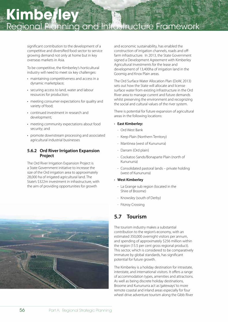
KimberleyRegional Planning and Infrastructure Framework
56 Part A: Regional Strategic Planning
significant contribution to the development of a competitive and diversified food sector to service growing demand not only at home but in key overseas markets in Asia.
To be competitive, the Kimberley’s horticultural industry will need to meet six key challenges:
• maintaining competitiveness and access in a dynamic marketplace;
• securing access to land, water and labour resources for production;
• meeting consumer expectations for quality and variety of food;
• continued investment in research and development;
• meeting community expectations about food security; and
• promote downstream processing and associated agricultural industrial businesses
5.6.2 Ord River Irrigation Expansion Project
The Ord River Irrigation Expansion Project is a State Government initiative to increase the size of the Ord irrigation area to approximately 28,000 ha of irrigated agricultural land. The State’s $322m investment in infrastructure, with the aim of providing opportunities for growth
and economic sustainability, has enabled the construction of irrigation channels, roads and off-farm infrastructure. In 2013, the State Government signed a Development Agreement with Kimberley Agricultural Investments for the lease and development of 13,400ha of irrigation land in the Goomig and Knox Plain areas.
The Ord Surface Water Allocation Plan (DoW, 2013) sets out how the State will allocate and license surface water from existing infrastructure in the Ord River area to manage current and future demands whilst preserving the environment and recognizing the social and cultural values of the river system.
There is potential for future expansion of agricultural areas in the following locations:
• East Kimberley:
- Ord West Bank
- Keep Plain (Northern Territory)
- Mantinea (west of Kununurra)
- Darram (Ord plain)
- Cockatoo Sands/Bonaparte Plain (north of Kununurra)
- Consolidated pastoral lands – private holding (west of Kununurra)
• West Kimberley
- La Grange sub region (located in the Shire of Broome)
- Knowsley (south of Derby)
- Fitzroy Crossing
5.7 Tourism
The tourism industry makes a substantial contribution to the region’s economy, with an estimated 350,000 overnight visitors per annum, and spending of approximately $256 million within the region (15.5 per cent gross regional product). This sector, which is considered to be comparatively immature by global standards, has significant potential for future growth.
The Kimberley is a holiday destination for intrastate, interstate, and international visitors. It offers a range of accommodation types, amenities and attractions. As well as being discrete holiday destinations, Broome and Kununurra act as ‘gateways’ to more remote coastal and inland areas especially for four wheel drive adventure tourism along the Gibb River
KimberleyRegional Planning and Infrastructure Framework
57Part A: Regional Strategic Planning
Road. Popular natural attractions for self-drive visitors, include: Windjana Gorge National Park; Tunnel Creek National Park; Geikie Gorge National Park; King Leopold Ranges Conservation Park; Mitchell Falls National Park; and Purnululu National Park.
Other significant forms of tourism include charter boats and cruise ships, which traverse the region’s isolated coast line offering sightseeing and fishing products. The number of vessels offering these opportunities has increased steadily in recent times and this trend is expected to continue. Scenic air tours, which operate from Broome and Kununurra, provide opportunities for sightseeing with some operators offering remote camping experiences.
Tourism centred on the region’s Aboriginal culture is also becoming a popular feature of the tourism industry. At present, there is a diverse range of products on offer such as bush food tours, fishing, kayaking, traditional knowledge sharing, rock art tours and a number of contemporary art galleries. Aboriginal communities on the Dampier Peninsula, north of Broome, offer a range or tourism experiences, which receive more than 30,000 visitors a year.
5.7.1 Future economic development opportunities in the tourism sector
Further expansion of the tourism sector is likely to occur both within settlements and in more remote areas.
Development within settlements will focus on providing a range of accommodation to suit the differing needs and aspirations of visitors. Associated amenities and attractions will also need to emphasise and accentuate unique aspects of places such as historical and cultural legacy. Tourism activities in more remote areas will focus on unique aspects of the natural and cultural environment.
Establishing tourism ventures in remote regions like the Kimberley can be very expensive, in terms of building and construction costs, accessing goods and materials, and securing workforces. These issues represent significant, ongoing challenges to the industry. Developing the industry in a sustainable manner that reduces impacts on the region’s attractions, given that many of these are based on the natural environment, will be an important consideration. While the potential for the region to offer quality tourism experiences in the future is
substantial it is recognised that facilitating growth will require a coordinated focus from a range of stakeholders in the private sector, State and local government, and Aboriginal interests.
5.7.2 Accommodation and land
To ensure the growth of the tourism industry, it will be necessary to identify and secure land for tourism development within major settlements. Substantial costs to establish tourism activities can, however, be a major barrier to would-be developers who may seek more ‘secure’ returns on investment by pursuing residential development ventures. This has resulted in local governments introducing provisions in local planning schemes that aim to ‘protect’ significant tourism sites from residential development. This practice will need to continue into the future.
To ensure the tourism industry develops in a manner that does not damage and/or devalue the region’s natural attractions visitors should be managed appropriately. The issue was examined in detail as part of the KSCS, which addresses the requirement to manage visitors by defining the following specific strategies:
• upgrade camping, picnic, interpretive and associated visitor facilities to enhance visitor experiences and increase the capacity to cater for visitors at key tourist parks;
• undertake priority conservation works to protect highly visited historical sites;
• address impacts of informal access to unregistered sites in the region’s National Parks and reserves;
• facilitate quality environmentally and culturally sensitive accommodation;
• develop and promote tourism corridors across the region involving upgraded and new camping facilities and interpretive signage, and linking sites of interest with camping facilities approximately one day’s drive apart; and
• a $35million dollar investment by the State commenced in 2013-14 to improve caravan and camping options across WA, including the Kimberley.
5.7.3 Aboriginal involvement
Cultural tourism is also a key strength of the region, offering an extensive range of Aboriginal attractions, activities and accommodation. The future potential of this industry has been recognised by the KSCS and the Kimberley National Landscapes – Experience
KimberleyRegional Planning and Infrastructure Framework
58 Part A: Regional Strategic Planning
Development Strategies. These strategies provide opportunities for Aboriginal tourism businesses to build their capacity and to establish the region as Australia’s premier Aboriginal cultural tourism destination.
Initiatives will provide for:
• expansion of Aboriginal tourism operations and products being offered;
• opportunities for visitors to have Aboriginal tourism experiences; and
• opportunities for Aboriginal communities to benefit from tourism.
This represents a way for Aboriginal people to become more involved in the mainstream economy.
5.8 Resources
In 2013, the resources sector contributed $1.13b to the region’s economy. At this time, the most significant commodities (by value) were iron ore, diamonds/crude oil, and nickel/copper/cobalt/gold/silver.
The most significant are the offshore gas reserves of the Browse Basin, which are estimated to contain 33.4 tcf as well as conventional petroleum and unconventional gas in the Canning Basin.
In terms of minerals, there are substantial bauxite deposits located in the Mitchell Plateau, Cape Bougainville and Mt Leeming/East Kalumburu areas. The region also has significant deposits of other minerals and energy sources, including: heavy mineral sands (Dampier Peninsula), lead/silver (Sorby Hills), coal (Duchess Paradise),gold (Lamboo) and rare earths (Browns Range).
5.8.1 Future economic development opportunities in resources sector
The resources sector will continue to play a major role in the economic development of the region. A number of significant projects are currently being investigated by proponents, particularly those that will process natural gas and extracting minerals (e.g. iron ore and diamonds) from ore deposits located inland. Commencement of these projects is closely linked to variables such as world commodity prices, availability of infrastructure and detailed analysis of potential site impacts.
Mineral extraction
The Kimberley Profile contains a list of mineral extraction projects that are being investigated across the region. At present these include; heavy mineral sands (Dampier Peninsula), lead/silver (Sorby Hills), coal (Duchess, Paradise) and gold (Lamboo) developments.
These projects are at varying stages of feasibility and approvals. Any project commencement will have significant implications for settlement development, employment and infrastructure provision across the region. The region also has considerable mineral deposits but many of these are considered unfeasible at the present time.
Oil and gas
The region is located close to significant offshore gas reserves of the Browse Basin. Some of the retention leases for these reserves are administered by the Commonwealth while others are in the State’s jurisdiction. At the present time, these leases are held by a number of multi-national petroleum exploration companies.
Other opportunities include the discovery of conventional petroleum and ‘tight’ gas within the Canning Basin. The Canning Basin covers 530,000 km2, stretching from the coast between Port Hedland and Broome, to the State’s eastern border. In the basin natural gas deposits, which are held in shale rock has been speculated that there could be in the vicinity of 235 tcf of unconventional gas. The resource is entirely owned by the State. Development will bolster the supply of natural gas for domestic markets as well as providing a possible feedstock for gas processing operations.
Buru Energy/Mitsubishi Joint Venture - Canning Basin
The Canning basin is home to what is potentially the largest onshore resource of unconventional gas in Australia. A number of companies have commenced exploration in the area, including Buru Energy and Mitsubishi Corporation, Apache Energy, New Standard Energy, ConocoPhillips, Petro China, Key Petroleum and the Hess Corporation.
Buru Energy Limited and Mitsubishi Corporation are currently investigating the potential of the basin’s tight gas resource contained in the Laurel Formation, located 2 – 3 km below the surface. This is supported by the State with the Natural Gas (Canning Basin Joint Venture) Agreement Act 2013, which targets the
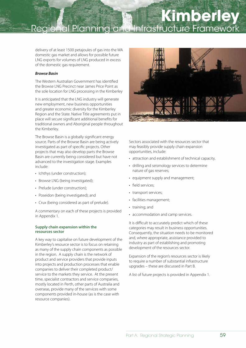
KimberleyRegional Planning and Infrastructure Framework
59Part A: Regional Strategic Planning
delivery of at least 1500 petajoules of gas into the WA domestic gas market and allows for possible future LNG exports for volumes of LNG produced in excess of the domestic gas requirement.
Browse Basin
The Western Australian Government has identified the Browse LNG Precinct near James Price Point as the sole location for LNG processing in the Kimberley
It is anticipated that the LNG industry will generate new employment, new business opportunities and greater economic diversity for the Kimberley Region and the State. Native Title agreements put in place will secure significant additional benefits for traditional owners and Aboriginal people throughout the Kimberley.
The Browse Basin is a globally significant energy source. Parts of the Browse Basin are being actively investigated as part of specific projects. Other projects that may also develop parts the Browse Basin are currently being considered but have not advanced to the investigation stage. Examples include:
• Ichthys (under construction);
• Browse LNG (being investigated);
• Prelude (under construction);
• Poseidon (being investigated); and
• Crux (being considered as part of prelude).
A commentary on each of these projects is provided in Appendix 1.
Supply chain expansion within the resources sector
A key way to capitalise on future development of the Kimberley’s resource sector is to focus on retaining as many of the supply chain components as possible in the region. A supply chain is the network of product and service providers that provide inputs into projects and production processes that enable companies to deliver their completed product/service to the markets they service. At the present time, specialist contractors and service companies, mostly located in Perth, other parts of Australia and overseas, provide many of the services with some components provided in-house (as is the case with resource companies).
Sectors associated with the resources sector that may feasibly provide supply chain expansion opportunities, include:
• attraction and establishment of technical capacity,
• drilling and seismology services to determine nature of gas reserves;
• equipment supply and management;
• field services;
• transport services;
• facilities management;
• training; and
• accommodation and camp services.
It is difficult to accurately predict which of these categories may result in business opportunities. Consequently, the situation needs to be monitored and, where appropriate, assistance provided to industry as part of establishing and promoting development of the resources sector.
Expansion of the region’s resources sector is likely to require a number of substantial infrastructure upgrades – these are discussed in Part B.
A list of future projects is provided in Appendix 1.
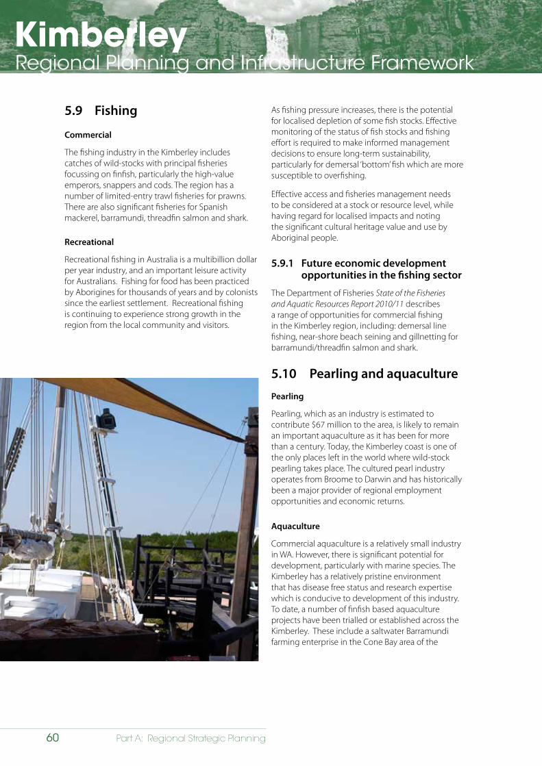
KimberleyRegional Planning and Infrastructure Framework
60 Part A: Regional Strategic Planning
5.9 Fishing
Commercial
The fishing industry in the Kimberley includes catches of wild-stocks with principal fisheries focussing on finfish, particularly the high-value emperors, snappers and cods. The region has a number of limited-entry trawl fisheries for prawns. There are also significant fisheries for Spanish mackerel, barramundi, threadfin salmon and shark.
Recreational
Recreational fishing in Australia is a multibillion dollar per year industry, and an important leisure activity for Australians. Fishing for food has been practiced by Aborigines for thousands of years and by colonists since the earliest settlement. Recreational fishing is continuing to experience strong growth in the region from the local community and visitors.
As fishing pressure increases, there is the potential for localised depletion of some fish stocks. Effective monitoring of the status of fish stocks and fishing effort is required to make informed management decisions to ensure long-term sustainability, particularly for demersal ‘bottom’ fish which are more susceptible to overfishing.
Effective access and fisheries management needs to be considered at a stock or resource level, while having regard for localised impacts and noting the significant cultural heritage value and use by Aboriginal people.
5.9.1 Future economic development opportunities in the fishing sector
The Department of Fisheries State of the Fisheries and Aquatic Resources Report 2010/11 describes a range of opportunities for commercial fishing in the Kimberley region, including: demersal line fishing, near-shore beach seining and gillnetting for barramundi/threadfin salmon and shark.
5.10 Pearling and aquaculture
Pearling
Pearling, which as an industry is estimated to contribute $67 million to the area, is likely to remain an important aquaculture as it has been for more than a century. Today, the Kimberley coast is one of the only places left in the world where wild-stock pearling takes place. The cultured pearl industry operates from Broome to Darwin and has historically been a major provider of regional employment opportunities and economic returns.
Aquaculture
Commercial aquaculture is a relatively small industry in WA. However, there is significant potential for development, particularly with marine species. The Kimberley has a relatively pristine environment that has disease free status and research expertise which is conducive to development of this industry. To date, a number of finfish based aquaculture projects have been trialled or established across the Kimberley. These include a saltwater Barramundi farming enterprise in the Cone Bay area of the
KimberleyRegional Planning and Infrastructure Framework
61Part A: Regional Strategic Planning
Buccaneer Archipelago, which has recently gained approval to extend the number of its leases. It is seeking to raise more capital to expand infrastructure. In this location, the Department of Fisheries has established the Kimberley Aquaculture Development Zone (KADZ).
The KADZ is located in Cone Bay, at the northern end of King Sound, about 215 kilometres north east of Broome. Although situated in the Shire of Derby/West Kimberley, its location provides significant pre and post farm-gate opportunities within the Shire of Broome on the Dampier Peninsula. The traditional custodians of the land and saltwater, the Bardi Jawi, Mayala and Dambimangari people together recognise the need for appropriate strategic planning so that adequate provision is made for the necessary infrastructure to realise the full potential of the KADZ into the future.
The Western Australian Planning Commission has developed the Dampier Peninsula Planning Strategy (2015) which identifies in section 3.5.10, objectives, strategies and actions to further articulate future planning requirements to complement the development of the KADZ.
5.10.1 Future economic development opportunities in the pearling/aquaculture sectors
The Kimberley region has potential for a wide range of aquaculture developments given its unique environment. Potential projects are likely to include: pearling; trochus (shellfish); barramundi; oysters; mussels; prawns and the provision of associated economic development.
5.11 Defence
At present, the Australian Defence Force (ADF) has a ‘low visibility’ presence in Northern Australia focused on border protection. Although navy vessels use Broome as a rest and resupply port during their patrols of the North West oceans there is no dedicated naval base.
5.11.1 Future economic development opportunities for the defence sector
The Australian Defence Force’s White Paper (2013) recommends that an increased and more visible ADF presence is warranted in Australia’s North West. This is due to the area becoming a global source of liquefied natural gas and other petroleum resource exports. As a result, there will be a requirement to ensure freedom and security of the sea lines of communication in the Indian Ocean.
The Australian Defence Force Posture Review (ADF 2012) recommends that:
‘While permanent Navy bases in the North West are not operationally necessary, the ADF should examine options relating to investment in civil and logistics infrastructure in the north-west to support operations’.
The location of additional infrastructure to support the sector is likely to have significant economic flow on effects for the region. For example, the RAAF Curtin Aerodrome, near Derby, is identified for upgrades to support Joint Strike Fighters and this will increase activity at the facility; giving it opportunity for further investment as a strategic defence base.
The White Paper indicates that the defence industry will continue to build upon existing relationships with regional communities and partners in the north-west. The ADF’s presence and visibility in the region will be enhanced in close consultation with State Governments, industry and local communities.
KimberleyRegional Planning and Infrastructure Framework
62 Part A: Regional Strategic Planning
5.12 Service and commercial sectors
The Kimberley’s service sector includes community and governance (health, education, local, State and federal government services); retail, wholesale and hospitality services; and to a lesser extent business, property, media, information technology and consulting. The Kimberley’s commercial sector includes retail and entertainment activities; and office spaces. The sectors are a significant employer across the region with the widest range of activities found in Broome and Kununurra. The $130m West Kimberley Revitalisation Plan, which was announced in 2013, included $10m for redevelopment of the Chinatown in Broome.
5.12.1 Future economic development opportunities in the service and commercial sectors
The service and commercial sectors are likely to retain a significant presence in the region’s settlements over the next 25 years. Anticipated population growth will result in the need to expand existing, and to develop new, services and commercial operations. Growth in the service sector is likely to be most evident in welfare provision, health and education. Expansion of hospitality services is also likely given the drive to significantly expand the tourism sector.
There is likely to be sufficient demand to support a range of higher order commercial uses such as service commercial and showrooms, additional office spaces and more entertainment, services and amenities in key centres of Broome, Kununurra and Derby.
The service and commercial sectors will continue to be important providers of employment opportunities throughout the region’s settlements. Change in this sector is also likely to result in increased demand for affordable additional land and housing and land.
5.13 Supply chain completion
Opportunities for supply chain expansion relating to the resources sector has already been discussed in Section 5.8 – Resources. It is also important, however, to differentiate between resource based supply chain expansion and new economic drivers and their associated supply chains. Whereas a focus on resource-based supply chain expansion is likely to strengthen the region’s resources specialisation there are new industries that also have supply chains. Expansion of these will aid greater economic diversification across the region.
It is recognised that supply chains are now an integral part of the supply and procurement practices of major resource companies and that there is a need for stakeholders and decision-makers to collaboratively identify and promote the development of supply chain infrastructure in the Kimberley region.
Potential areas for supply chain expansion are:
• primary production (e.g. transportation and processing of goods);
• tourism and hospitality (e.g. focussing on regionally-specific attractions);
• warehouse, service commercial, distribution and retail activities in identified key service centres;
• community and governance (e.g. relocation of government functions to the region);
• defence facilities (e.g. establishing a purpose-based defence facility);
• education and training (e.g. establishing a university or training facility); and
• business, media, IT and consulting.
New and upgraded infrastructure, particularly to the region’s movement networks – e.g. Broome Port and the region’s airports, will be required to facilitate this aim. This is discussed in greater depth in Part B.
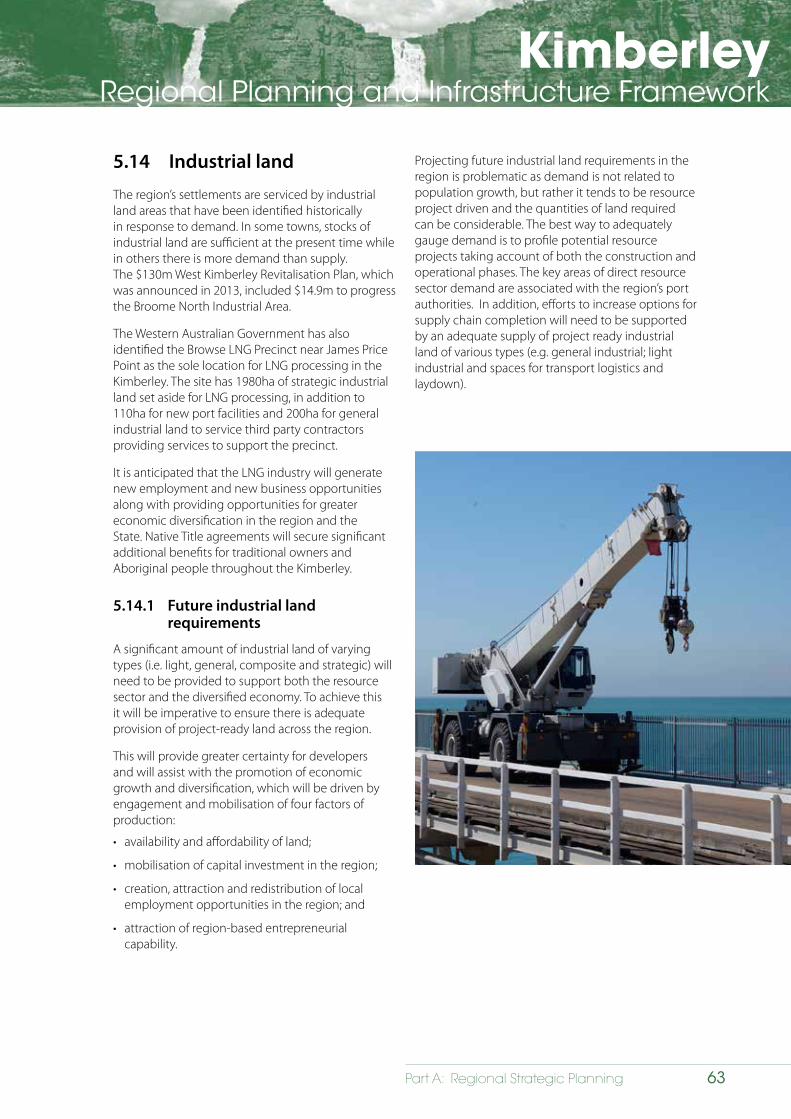
KimberleyRegional Planning and Infrastructure Framework
63Part A: Regional Strategic Planning
5.14 Industrial land
The region’s settlements are serviced by industrial land areas that have been identified historically in response to demand. In some towns, stocks of industrial land are sufficient at the present time while in others there is more demand than supply. The $130m West Kimberley Revitalisation Plan, which was announced in 2013, included $14.9m to progress the Broome North Industrial Area.
The Western Australian Government has also identified the Browse LNG Precinct near James Price Point as the sole location for LNG processing in the Kimberley. The site has 1980ha of strategic industrial land set aside for LNG processing, in addition to 110ha for new port facilities and 200ha for general industrial land to service third party contractors providing services to support the precinct.
It is anticipated that the LNG industry will generate new employment and new business opportunities along with providing opportunities for greater economic diversification in the region and the State. Native Title agreements will secure significant additional benefits for traditional owners and Aboriginal people throughout the Kimberley.
5.14.1 Future industrial land requirements
A significant amount of industrial land of varying types (i.e. light, general, composite and strategic) will need to be provided to support both the resource sector and the diversified economy. To achieve this it will be imperative to ensure there is adequate provision of project-ready land across the region.
This will provide greater certainty for developers and will assist with the promotion of economic growth and diversification, which will be driven by engagement and mobilisation of four factors of production:
• availability and affordability of land;
• mobilisation of capital investment in the region;
• creation, attraction and redistribution of local employment opportunities in the region; and
• attraction of region-based entrepreneurial capability.
Projecting future industrial land requirements in the region is problematic as demand is not related to population growth, but rather it tends to be resource project driven and the quantities of land required can be considerable. The best way to adequately gauge demand is to profile potential resource projects taking account of both the construction and operational phases. The key areas of direct resource sector demand are associated with the region’s port authorities. In addition, efforts to increase options for supply chain completion will need to be supported by an adequate supply of project ready industrial land of various types (e.g. general industrial; light industrial and spaces for transport logistics and laydown).
KimberleyRegional Planning and Infrastructure Framework
64 Part A: Regional Strategic Planning
5.15 Labour force and employment
In 2009-10, the labour force of the Kimberley region totalled 16,746 people comprising 15,356 employed and 1,390 unemployed. The unemployment rate of the Kimberley was 8.3 per cent (compared to the State average of 4.3 per cent). In addition, it is important to note that a significant percentage of the population is not recorded as part of the formal workforce.
As highlighted in Figure 5.2, the most significant sectors in terms of employment across the region were:
• Construction (14.3%)
• Public Administration and Safety (9%); and
• Mining (8.5%).
These data can be attributed to:
• large construction workforces employed on large-scale projects that were being progressed across the region at the time of the Census of Population and Households in 2011;
• employment in ‘Public Administration and Safety’ has traditionally been high compared to other categories across the region and reflects the region’s significant population support/servicing function; and
• employment in the mining category, which reflects workforces at operating mines across the region.
5.15.1 Future employment opportunities
For regional and urban planning purposes the region’s future employment structure is most productively analysed and projected in terms of:
• driver/export;
• retail;
• consumer services;
• producer services;
• knowledge intensive consumer services; and
• knowledge intensive producer services.
The composition and characteristics of these groupings are outlined in Appendix 2.
The Kimberley region’s current employment structure can be characterised as predominantly ‘driver/export’ and ‘production services’, where the majority of people are employed in jobs as part of construction to support the mining and agriculture sectors.
It is anticipated that emerging opportunities in the region’s primary sectors, increased presence of the exploration industry, greater supply chain completion and identification of other new
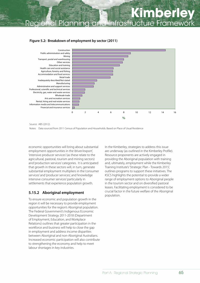
KimberleyRegional Planning and Infrastructure Framework
65Part A: Regional Strategic Planning
Figure 5.2: Breakdown of employment by sector (2011)
ConstructionPublic administration and safety
MiningTransport, postal and warehousing
Other servicesEducation and training
Health care and social assistanceAgriculture, forestry and �shing
Accommodation and food servicesRetail trade
Inadequately described/Not statedManufacturing
Administrative and support servicesProfessional, scienti�c and technical services
Electricity, gas, water and waste servicesWholesale trade
Arts and recreation servicesRental, hiring and real estate services
Information media and telecommunicationsFinancial and insurance services
0 2 4 6 8
%
10 12 14 16
Source: ABS (2012).
Notes: Data sourced from 2011 Census of Population and Households. Based on Place of Usual Residence
economic opportunities will bring about substantial employment opportunities in the ‘driver/export’, ‘intensive producer services’ (as these relate to the agricultural, pastoral, tourism and mining sectors) and ‘production services’ categories. It is anticipated that growth in these sectors will, in turn, generate substantial employment multipliers in the ‘consumer services’ and ‘producer services’, and ‘knowledge intensive consumer services’ particularly in settlements that experience population growth.
5.15.2 Aboriginal employment
To ensure economic and population growth in the region it will be necessary to provide employment opportunities for the region’s Aboriginal population. The Federal Government’s Indigenous Economic Development Strategy 2011-2018 (Department of Employment, Education, and Workplace Relations) outlines that greater participation in the workforce and business will help to close the gap in employment and address income disparities between Aboriginal and non-Aboriginal Australians. Increased economic participation will also contribute to strengthening the economy and help to meet labour shortages in key industries.
In the Kimberley, strategies to address this issue are underway (as outlined in the Kimberley Profile). Resource proponents are actively engaged in providing the Aboriginal population with training and, ultimately, employment while the Kimberley Training Institute’s ‘Strategic Plan - Towards 2015’, outlines programs to support these initiatives. The KSCS highlights the potential to provide a wider range of employment options to Aboriginal people in the tourism sector and on diversified pastoral leases. Facilitating employment is considered to be crucial factor in the future welfare of the Aboriginal population.
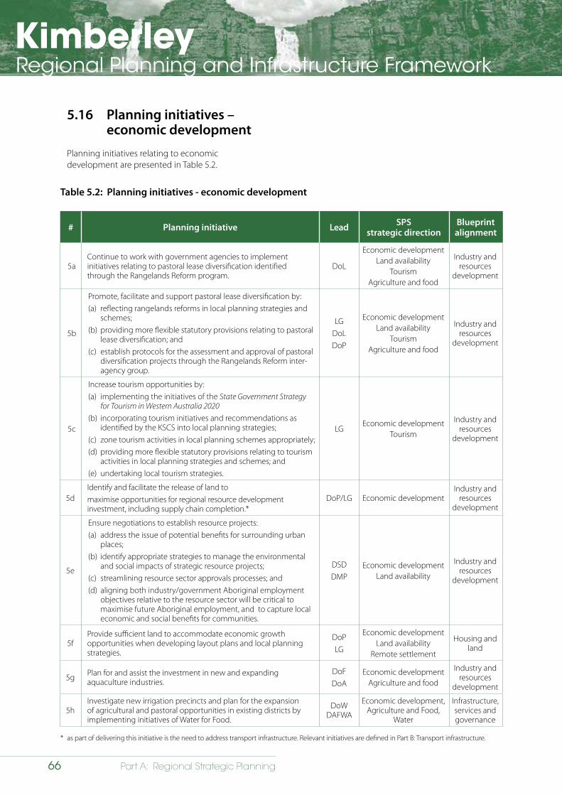
KimberleyRegional Planning and Infrastructure Framework
66 Part A: Regional Strategic Planning
5.16 Planning initiatives – economic development
Planning initiatives relating to economic development are presented in Table 5.2.
Table 5.2: Planning initiatives - economic development
# Planning initiative Lead SPSstrategic direction
Blueprintalignment
5aContinue to work with government agencies to implement initiatives relating to pastoral lease diversification identified through the Rangelands Reform program.
DoL
Economic developmentLand availability
TourismAgriculture and food
Industry and resources
development
5b
Promote, facilitate and support pastoral lease diversification by: (a) reflecting rangelands reforms in local planning strategies and
schemes; (b) providing more flexible statutory provisions relating to pastoral
lease diversification; and(c) establish protocols for the assessment and approval of pastoral
diversification projects through the Rangelands Reform inter-agency group.
LGDoLDoP
Economic developmentLand availability
TourismAgriculture and food
Industry and resources
development
5c
Increase tourism opportunities by: (a) implementing the initiatives of the State Government Strategy
for Tourism in Western Australia 2020(b) incorporating tourism initiatives and recommendations as
identified by the KSCS into local planning strategies;(c) zone tourism activities in local planning schemes appropriately;(d) providing more flexible statutory provisions relating to tourism
activities in local planning strategies and schemes; and(e) undertaking local tourism strategies.
LGEconomic development
Tourism
Industry and resources
development
5dIdentify and facilitate the release of land to maximise opportunities for regional resource development investment, including supply chain completion.*
DoP/LG Economic developmentIndustry and
resources development
5e
Ensure negotiations to establish resource projects: (a) address the issue of potential benefits for surrounding urban
places;(b) identify appropriate strategies to manage the environmental
and social impacts of strategic resource projects;(c) streamlining resource sector approvals processes; and(d) aligning both industry/government Aboriginal employment
objectives relative to the resource sector will be critical to maximise future Aboriginal employment, and to capture local economic and social benefits for communities.
DSDDMP
Economic developmentLand availability
Industry and resources
development
5fProvide sufficient land to accommodate economic growth opportunities when developing layout plans and local planning strategies.
DoPLG
Economic developmentLand availability
Remote settlement
Housing and land
5g Plan for and assist the investment in new and expanding aquaculture industries.
DoFDoA
Economic developmentAgriculture and food
Industry and resources
development
5hInvestigate new irrigation precincts and plan for the expansion of agricultural and pastoral opportunities in existing districts by implementing initiatives of Water for Food.
DoW DAFWA
Economic development, Agriculture and Food,
Water
Infrastructure, services and governance
* as part of delivering this initiative is the need to address transport infrastructure. Relevant initiatives are defined in Part B: Transport infrastructure.
KimberleyRegional Planning and Infrastructure Framework
67Part A: Regional Strategic Planning
6 Implementing a sustainable framework
6.1 Strategic direction
6.1.1 Overview
Implementing the Kimberley Regional Planning and Infrastructure Framework (KRPIF) will be central for achieving a sustainable, liveable and attractive urban form that is inclusive of all the region’s inhabitants. Constraints and impediments will need to be creatively addressed to transform the region.
6.1.2 Goal statement
Diversify and develop the region’s economy to facilitate population and settlement growth while protecting the Kimberley’s natural environment and cultural heritage values.
6.2 Issues, opportunities, initiatives
Devising an appropriate set of planning initiatives to deliver the KRPIF vision has followed a number of key steps: understanding the issues; identifying opportunities to address these issues and formulating initiatives to guide implementation.
The KRPIF was prepared following consultation with key stakeholders to identify relevant issues. These issues form the basis for discussion in each chapter and are summarised (by topic) as:
• respecting Aboriginal people and conforming with requirements of the Native Title Act 1993.
• protecting and cherishing the region’s heritage;
• understanding the population;
• diversifying the economy;
• developing sustainable settlements;
• providing employment and upskilling opportunities;
• ensuring greater involvement of the region’s Aboriginal population in land use planning;
• protecting the region’s unique environmental assets;
• providing sufficient utility infrastructure capacity to facilitate growth;
• ensuring community services infrastructure capacity will meet the needs of the population; and
• connecting the region’s settlements to the rest of Western Australia, interstate and overseas.
KimberleyRegional Planning and Infrastructure Framework
68 Part A: Regional Strategic Planning
Identified opportunities flow from an understanding of what is required to address these issues to ultimately transform the region in accordance with the KRPIF. The opportunities are presented throughout each chapter to focus the discussion on future requirements. As the final step in the strategy process they are then translated into meaningful, implementable initiatives at the end of each chapter.
6.3 Overarching issues
A number of significant overarching issues will impact on the delivery of the KRPIF. Planning initiatives to address these issues are presented in Table 6.1.
6.3.1 Engagement with Aboriginal people
The need for greater collaboration with the region’s Aboriginal people was identified as an issue by the Kimberley Regional Planning Committee at its commencement. A number of workshops were held with representatives from each of the Prescribed Bodies Corporate (PBCs) to identify ways to better include Traditional Owners in the planning process. The PBCs articulated their interest in being involved in strategic land use planning, especially in areas where there are demands for urban expansion, infrastructure provision and economic development.
In response to these desires expressed by the PBCs, the Traditional Owner Reference Group (TORG) was established to advise the Kimberley Regional Planning Committee with the key aim of establishing better ways to engage people in land use planning.
The following opportunities have been identified to improve engagement with Aboriginal people in the land use planning process:
• acknowledging the differing needs and aspirations of Aboriginal people in relation to land;
• inclusive, whole-of-government, engagement with both Traditional Owners and Historical People as relevant;
• ensuring the TORG meets regularly to advise the KRPC on current and emerging issues; and
• utilising a collaborative, cross-agency approach to indigenous consultation.
6.3.2 Native title
Effective land use planning plays an important role in assisting assessment of native title requirements and associated opportunities and constraints, including e.g. the development of Indigenous Land Use Agreements (ILUAs). In Fitzroy Crossing, for example, the Departments of Premier and Cabinet and Planning and other state government agencies are working towards native title agreement through ILUAs. It is not possible to fully implement the Fitzroy Futures Town Plan (FFTP) and associated land tenure reform in that town without first addressing the NTA’s requirements. The FFTP endorsed by the WAPC in 2009 has served as a useful blueprint for ILUA negotiations and planned divestment of land tenure to facilitate development.
The concurrent progression of local planning strategies in the Kimberley more broadly will identify future appropriate land uses and this information will likely inform native title future act negotiations and agreements in the region into the future.
Native title has been positively determined across most of the region, with more positive determinations likely in the future. Three shires are currently preparing district schemes (these are schemes that apply to the whole Shire) and this will result in native title determination areas having formal land use classifications and being zoned for the first time. It should be noted that the zoning of land under a scheme is not a future act and does not attract procedural rights under the
KimberleyRegional Planning and Infrastructure Framework
69Part A: Regional Strategic Planning
The following opportunities have been identified to better incorporate native title into land use planning:
• improving local and regional planning policies to better articulate the relationship between native title and heritage legislation and land use planning processes; and
• productively engaging with the region’s PBC’s, principally through the TORG, when preparing land use plans and making land use planning decisions on Country.
NTA. However the actual development of the land, in many instances will constitute a future act and require conformity with the NTA before development can occur. As such, the WAPC seeks productive engagement with native title parties in land use planning as a means of facilitating responsible development in the Kimberley.
In 2012, the (then) Department of Local Government requested each local government in the Kimberley to undertake a study of Indigenous settlements to assess the implication on the Shire of this transfer of responsibility. From here the Department of Local Government will assess the implications of the policy on the Western Australian Government as a whole.
Initial recommendations from the studies undertaken by local governments propose establishing a district approach to service delivery whereby key service centres are identified to support a district catchment of smaller settlements. Key service centres could be selected based on criteria such as accessibility (distance from smaller settlements in the catchment, and bituminised roads not subject to flooding); current (and potential future capacity) of services such as secondary schools, regular health clinic, post office, mechanics and shop offering a good range of weekly shopping needs.
Secondary centres could offer limited daily shopping needs, primary school, remote / travelling nurse, but would need to visit the key service centre for more significant goods and services.
Uncertainty regarding continued Commonwealth funding and the role of Community Councils makes assessment of this ‘hub and spoke’ service delivery model problematic. The success of any service delivery model will also need effective consultation and agreement with Traditional Owners and community residents.
The following opportunity has been identified relating to servicing of Aboriginal settlements:
• plan for the equitable and effective provision of Infrastructure in Aboriginal settlements.
6.3.3 Services to remote Aboriginal towns and settlements
Larger Aboriginal settlements in the Kimberley are serviced with essential services by a number of different programs, including the Department of Housing’s Remote Area Essential Services Program (RAESP) and Horizon Power’s Aboriginal and Remote Communities Power Supply Project, which are jointly funded by the Commonwealth and State governments. The Department of Housing through the RAESP manages water and sewer. Municipal services are provided by the Commonwealth under the Municipal Services Program.
In 2006, the Government of Western Australia and the Australian Government signed a bilateral agreement on Indigenous affairs that aimed to improve the circumstances of Aboriginal people in WA. The agreement included a commitment for local governments to take responsibility for local government services in Aboriginal settlements, where funds and resources are provided to support this concept.
KimberleyRegional Planning and Infrastructure Framework
70 Part A: Regional Strategic Planning
6.3.4 Climate change
The potential impacts of climate change are an overarching concern when addressing land use planning and development in the Kimberley, impacts from climate change include:
• damage from extreme weather events (e.g. cyclones);
• sea level rise and coastal inundation and the impacts on coastal resources and values, including: habitat, ports, infrastructure and communities;
• catchment flooding;
• broad-scale impact on biodiversity; and
• hazards associated with fire frequency and behaviour.
Implications of climate change across the region would include:
• environmental variability;
• water shortages;
• exacerbation of existing environmental issues;
• stability of existing settlements and infrastructure; and
• community impacts (increased temperatures, flooding, water shortages).
It is important to plan and manage the impacts of climate change on future growth and development. This issue should be considered on a risk management basis that takes into account the susceptibility of proposed land uses, the location of development and the probability that an extreme event will eventuate within a certain timeframe.
6.3.5 Basic raw materials
Extraction of basic raw materials (BRM) is required for all new and maintenance of existing infrastructure. A lack of local BRM supply would likely lead to increased material prices, which would impact housing affordability and increase the cost of government projects.
Basic raw materials are defined as a mineral when on Crown land, and hence the need for mining leases under the Mining Act 1978 for commercial basic raw material extraction on Crown land. However, on private property, basic raw material extraction and sale is not covered by the Mining Act but authorised by Local government through grant of Extractive Industry Licences. Irrespective of the land type, commercial extraction of BRM is covered by the Mines Safety and Inspection Act 1994 to protect the health and safety of the workforce..
In 2013, the Geological Survey of Western Australia (GSWA) published maps of ‘Basic raw material resources’. The mapping covers the areas around Broome and Derby and extends onto the Dampier Peninsula. These maps are a valuable asset when planning as they provide context on availability of BRM and can assist in identifying those areas requiring planning protection.
As some of the proposed future development will occur on low-lying, flood-prone land it will be necessary to source and transport large quantities of fill material to ensure construction occurs at appropriate heights to mitigate risks. This will require a ready supply of basic raw materials (along with best practice stormwater and water-sensitive urban design).
With the exception of Broome and the Dampier Peninsula, there has not been any assessment of basic raw materials (BRM), nor has the use of potential substitutes been fully explored. Reports undertaken to date, however, identify a shortage of local materials that are suitable for fill, with much of the limited sand supplies constrained by environmental and/or heritage significance considerations.
An essential requirement is a program to determine the availability of supplies and consider the cost effectiveness of using alternative sources where essential supplies are limited. It is critical that practical strategies be put in place to identify locations where large quantities of suitable material can be excavated in an environmentally sustainable and cost effective manner.
The following opportunity has been identified for managing climate change:
• plan appropriately for the effects of extreme weather events and climate change in settlement areas across the region.
KimberleyRegional Planning and Infrastructure Framework
71Part A: Regional Strategic Planning
6.4 GovernanceThe successful implementation of the KRPIF will require effective partnerships between key stakeholders with clearly defined roles and responsibilities.
6.4.1 State Government
Committees include the Kimberley Regional Planning Committee and WAPC whose decisions or recommendations will be guided by the KRPIF, the ICC (Section 9.5.5), the board of the Kimberley Development Commission and the Regional Development Council.
At a State Government level there is need for coordination between ministers and their respective departments (e.g. Department of Planning, Department of Regional Development, Department of Lands, Department of State Development) and key stakeholders.
6.4.2 Department of Planning
The Department of Planning will play a crucial role in implementing the KRPIF. It will be responsible for:
• undertaking identified reviews of existing planning procedures and practises to effectively implement the KRPIF across the region;
• review existing policy and develop new policies; and
• provide leadership and guidance as part of stakeholder consultation across the region.
6.4.3 Local planning strategies and schemes
A critical component of implementing the KRPIF will be the review and/or preparation of local planning strategies and local planning schemes across the region by local government. When preparing these documents, local governments should consider the
objectives and initiatives outlined throughout this document. The status of work currently underway is summarised in Figure 6.1.
6.4.4 Related strategies
The KRPIF acknowledges relevant work that is already being undertaken by other State agencies to address issues in the Kimberley. Of particular importance are the Kimberley Science and Conservation Strategy (Department of Parks and Wildlife and Tourism WA), the Rangelands Reform Program (Department of Lands) and the Kimberley Regional Investment Blueprint (Kimberley Development Commission).
6.4.5 Infrastructure
To facilitate the development of land and housing in the Kimberley it will be necessary to provide adequate utility, community service and transport infrastructure. The WAPC’s Infrastructure Coordinating Committee will take a lead role and, together with the relevant servicing agencies and the Kimberley Development Commission, will ensure infrastructure is provided in a timely manner.
6.4.6 Consultation
Effective implementation will not only require consultation between agencies but also the region’s population, including the significant Aboriginal population (Table 6.2).
6.5 Monitoring and review
The KRPIF will be a ‘living document’ subject to regular review, update and improvement. Subsequent editions of the document will take into account new and updated information; review the opportunities/initiatives; and address additional important issues that have not been addressed in this version of the document. The accompanying Kimberley Regional Profile will also be updated as required.
A reporting and monitoring structure will be developed as part of the KRPIF so that an annual progress report on implementing the initiatives can be prepared. Over time, this structure will include a set of indicators (in accordance with the new State Planning Strategy) to assess the effectiveness of initiatives stated in the document.
The following opportunity has been identified for basic raw materials:
• develop a better understanding of the locations of basic raw materials is needed, especially those materials required for construction and development.
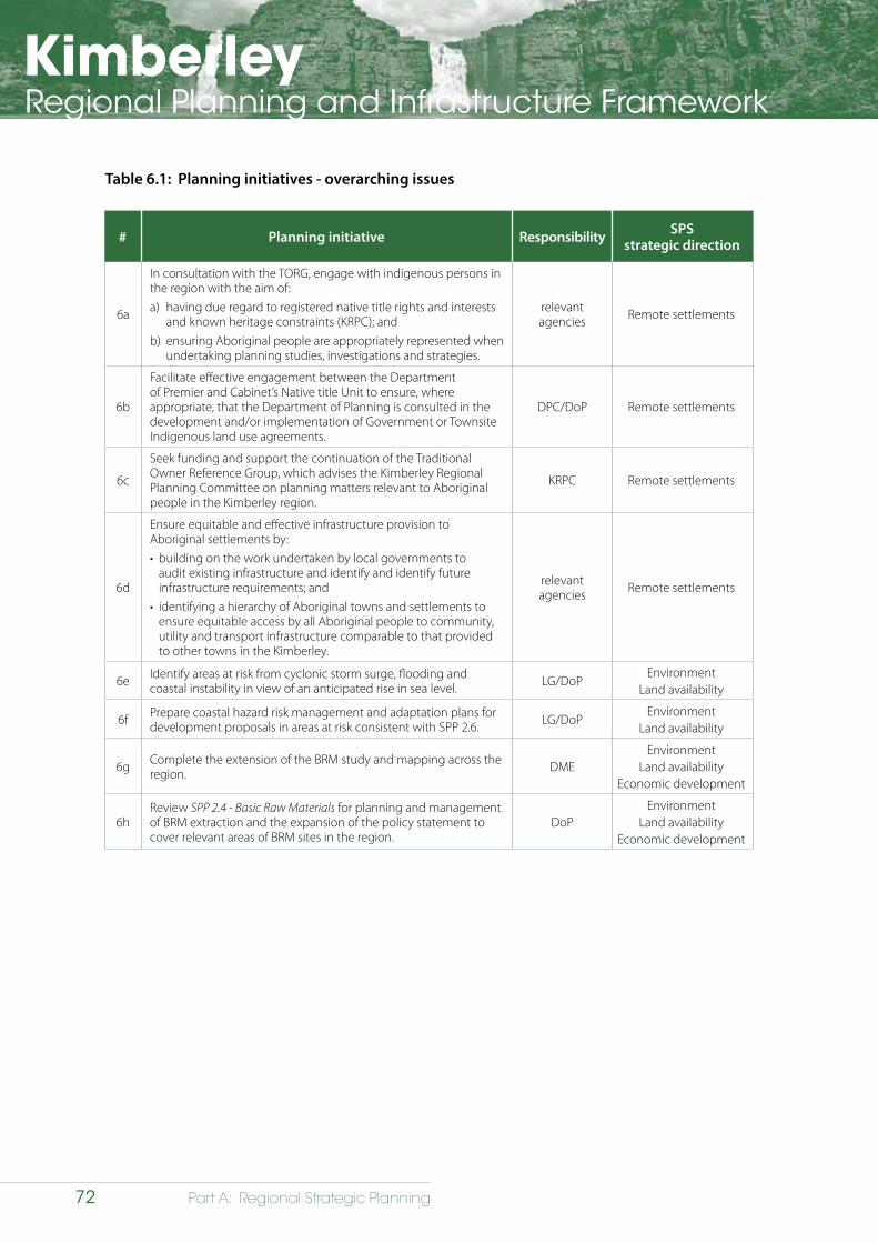
KimberleyRegional Planning and Infrastructure Framework
72 Part A: Regional Strategic Planning
# Planning initiative Responsibility SPSstrategic direction
6a
In consultation with the TORG, engage with indigenous persons in the region with the aim of:a) having due regard to registered native title rights and interests
and known heritage constraints (KRPC); andb) ensuring Aboriginal people are appropriately represented when
undertaking planning studies, investigations and strategies.
relevant agencies Remote settlements
6b
Facilitate effective engagement between the Department of Premier and Cabinet’s Native title Unit to ensure, where appropriate, that the Department of Planning is consulted in the development and/or implementation of Government or Townsite Indigenous land use agreements.
DPC/DoP Remote settlements
6c
Seek funding and support the continuation of the Traditional Owner Reference Group, which advises the Kimberley Regional Planning Committee on planning matters relevant to Aboriginal people in the Kimberley region.
KRPC Remote settlements
6d
Ensure equitable and effective infrastructure provision to Aboriginal settlements by:• building on the work undertaken by local governments to
audit existing infrastructure and identify and identify future infrastructure requirements; and
• identifying a hierarchy of Aboriginal towns and settlements to ensure equitable access by all Aboriginal people to community, utility and transport infrastructure comparable to that provided to other towns in the Kimberley.
relevant agencies Remote settlements
6e Identify areas at risk from cyclonic storm surge, flooding and coastal instability in view of an anticipated rise in sea level. LG/DoP
EnvironmentLand availability
6f Prepare coastal hazard risk management and adaptation plans for development proposals in areas at risk consistent with SPP 2.6. LG/DoP
EnvironmentLand availability
6g Complete the extension of the BRM study and mapping across the region. DME
EnvironmentLand availability
Economic development
6hReview SPP 2.4 - Basic Raw Materials for planning and management of BRM extraction and the expansion of the policy statement to cover relevant areas of BRM sites in the region.
DoPEnvironment
Land availabilityEconomic development
Table 6.1: Planning initiatives - overarching issues
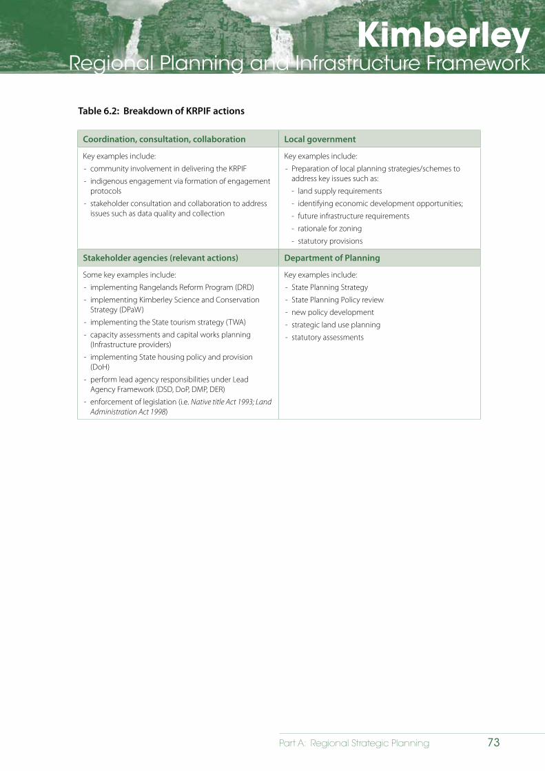
KimberleyRegional Planning and Infrastructure Framework
73Part A: Regional Strategic Planning
Coordination, consultation, collaboration Local government
Key examples include:
- community involvement in delivering the KRPIF
- indigenous engagement via formation of engagement protocols
- stakeholder consultation and collaboration to address issues such as data quality and collection
Key examples include:
- Preparation of local planning strategies/schemes to address key issues such as:
- land supply requirements
- identifying economic development opportunities;
- future infrastructure requirements
- rationale for zoning
- statutory provisions
Stakeholder agencies (relevant actions) Department of Planning
Some key examples include:
- implementing Rangelands Reform Program (DRD)
- implementing Kimberley Science and Conservation Strategy (DPaW)
- implementing the State tourism strategy (TWA)
- capacity assessments and capital works planning (Infrastructure providers)
- implementing State housing policy and provision (DoH)
- perform lead agency responsibilities under Lead Agency Framework (DSD, DoP, DMP, DER)
- enforcement of legislation (i.e. Native title Act 1993; Land Administration Act 1998)
Key examples include:
- State Planning Strategy
- State Planning Policy review
- new policy development
- strategic land use planning
- statutory assessments
Table 6.2: Breakdown of KRPIF actions
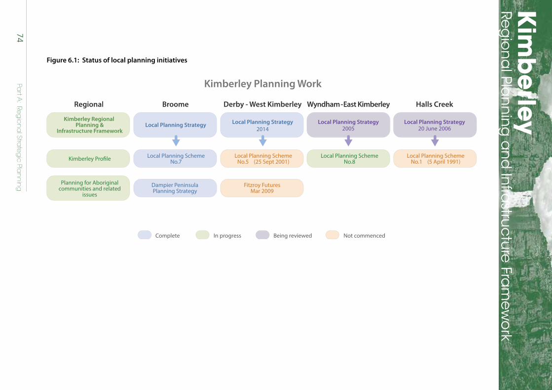
Kim
berley
Reg
ion
al Pla
nn
ing
an
d In
frastru
ctu
re Fra
mew
ork
74Pa
rt A: Re
gio
na
l Strate
gic
Plan
nin
g
Figure 6.1: Status of local planning initiatives
Kimberley Planning Work
Broome
Local Planning Strategy2014
Derby - West Kimberley Wyndham - East Kimberley Halls Creek
Kimberley Regional Planning &
Infrastructure Framework
Regional
Local Planning SchemeNo.7
Local Planning SchemeNo.5 (25 Sept 2001)
Local Planning SchemeNo.8
Local Planning SchemeNo.1 (5 April 1991)Kimberley Pro�le
Fitzroy FuturesMar 2009
Local Planning Strategy Local Planning Strategy20 June 2006
Local Planning Strategy2005
Dampier PeninsulaPlanning Strategy
Complete In progress Being reviewed Not commenced
Planning for Aboriginalcommunities and related
issues
Kimberley Regional Planning &
Infrastructure Framework
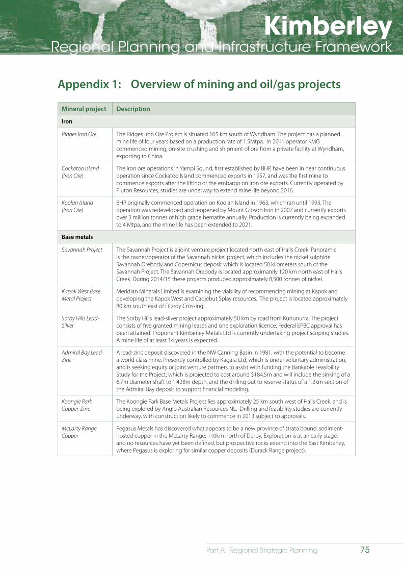
KimberleyRegional Planning and Infrastructure Framework
75Part A: Regional Strategic Planning
Appendix 1: Overview of mining and oil/gas projects
Mineral project Description
Iron
Ridges Iron Ore The Ridges Iron Ore Project is situated 165 km south of Wyndham. The project has a planned mine life of four years based on a production rate of 1.5Mtpa. In 2011 operator KMG commenced mining, on-site crushing and shipment of ore from a private facility at Wyndham, exporting to China.
Cockatoo Island (Iron Ore)
The iron ore operations in Yampi Sound, first established by BHP, have been in near continuous operation since Cockatoo Island commenced exports in 1957, and was the first mine to commence exports after the lifting of the embargo on iron ore exports. Currently operated by Pluton Resources, studies are underway to extend mine life beyond 2016.
Koolan Island(Iron Ore)
BHP originally commenced operation on Koolan Island in 1963, which ran until 1993. The operation was redeveloped and reopened by Mount Gibson Iron in 2007 and currently exports over 3 million tonnes of high grade hematite annually. Production is currently being expanded to 4 Mtpa, and the mine life has been extended to 2021.
Base metals
Savannah Project The Savannah Project is a joint venture project located north east of Halls Creek. Panoramic is the owner/operator of the Savannah nickel project, which includes the nickel sulphide Savannah Orebody and Copernicus deposit which is located 50 kilometers south of the Savannah Project. The Savannah Orebody is located approximately 120 km north east of Halls Creek. During 2014/15 these projects produced approximately 8,500 tonnes of nickel.
Kapok West Base Metal Project
Meridian Minerals Limited is examining the viability of recommencing mining at Kapok and developing the Kapok West and Cadjebut Splay resources. The project is located approximately 80 km south east of Fitzroy Crossing.
Sorby Hills Lead-Silver
The Sorby Hills lead-silver project approximately 50 km by road from Kununurra. The project consists of five granted mining leases and one exploration licence. Federal EPBC approval has been attained. Proponent Kimberley Metals Ltd is currently undertaking project scoping studies. A mine life of at least 14 years is expected.
Admiral Bay Lead-Zinc
A lead-zinc deposit discovered in the NW Canning Basin in 1981, with the potential to become a world class mine. Presently controlled by Kagara Ltd, which is under voluntary administration, and is seeking equity or joint venture partners to assist with funding the Bankable Feasibility Study for the Project, which is projected to cost around $184.5m and will include the sinking of a 6.7m diameter shaft to 1,428m depth, and the drilling out to reserve status of a 1.2km section of the Admiral Bay deposit to support financial modeling.
Koongie Park Copper-Zinc
The Koongie Park Base Metals Project lies approximately 25 km south west of Halls Creek, and is being explored by Anglo Australian Resources NL. Drilling and feasibility studies are currently underway, with construction likely to commence in 2013 subject to approvals.
McLarty Range Copper
Pegasus Metals has discovered what appears to be a new province of strata bound, sediment-hosted copper in the McLarty Range, 110km north of Derby. Exploration is at an early stage, and no resources have yet been defined, but prospective rocks extend into the East Kimberley, where Pegasus is exploring for similar copper deposits (Durack Range project).
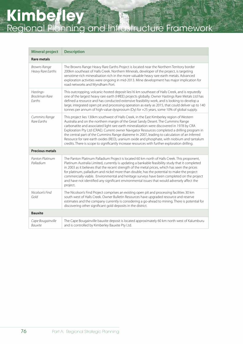
KimberleyRegional Planning and Infrastructure Framework
76 Part A: Regional Strategic Planning
Mineral project Description
Rare metals
Browns Range Heavy Rare Earths
The Browns Range Heavy Rare Earths Project is located near the Northern Territory border 200km southeast of Halls Creek. Northern Minerals, developer of the project, is targeting xenotime-rich mineralisation rich in the more valuable heavy rare earth metals. Advanced exploration activities were ongoing in mid-2013. Mine development has major implication for road networks and Wyndham Port.
Hastings-Brockman Rare Earths
This outcropping, volcanic-hosted deposit lies16 km southeast of Halls Creek, and is reputedly one of the largest heavy rare earth (HREE) projects globally. Owner Hastings Rare Metals Ltd has defined a resource and has conducted extensive feasibility work, and is looking to develop a large, integrated open pit and processing operation as early as 2015, that could deliver up to 140 tonnes per annum of high-value dysprosium (Dy) for +25 years, some 10% of global supply.
Cummins Range Rare Earths
This project lies 130km southwest of Halls Creek, in the East Kimberley region of Western Australia and on the northern margin of the Great Sandy Desert. The Cummins Range carbonatite and associated light rare earth mineralization were discovered in 1978 by CRA Exploration Pty Ltd (CRAE). Current owner Navigator Resources completed a drilling program in the central part of the Cummins Range diatreme In 2007, leading to calculation of an Inferred Resource for rare earth oxides (REO), uranium oxide and phosphate, with niobium and tantalum credits. There is scope to significantly increase resources with further exploration drilling.
Precious metals
Panton Platinum Palladium
The Panton Platinum Palladium Project is located 60 km north of Halls Creek. This proponent, Platinum Australia Limited, currently is updating a bankable feasibility study that it completed in 2003 as it believes that the recent strength of the metal prices, which has seen the prices for platinum, palladium and nickel more than double, has the potential to make the project commercially viable. Environmental and heritage surveys have been completed on the project and have not identified any significant environmental issues that would adversely affect the project.
Nicolson’s Find Gold
The Nicolson’s Find Project comprises an existing open pit and processing facilities 30 km south west of Halls Creek. Owner Bulletin Resources have upgraded resource and reserve estimates and the company currently is considering a go-ahead to mining. There is potential for discovering other significant gold deposits in the district.
Bauxite
Cape Bougainville Bauxite
The Cape Bougainville bauxite deposit is located approximately 60 km north west of Kalumburu and is controlled by Kimberley Bauxite Pty Ltd.
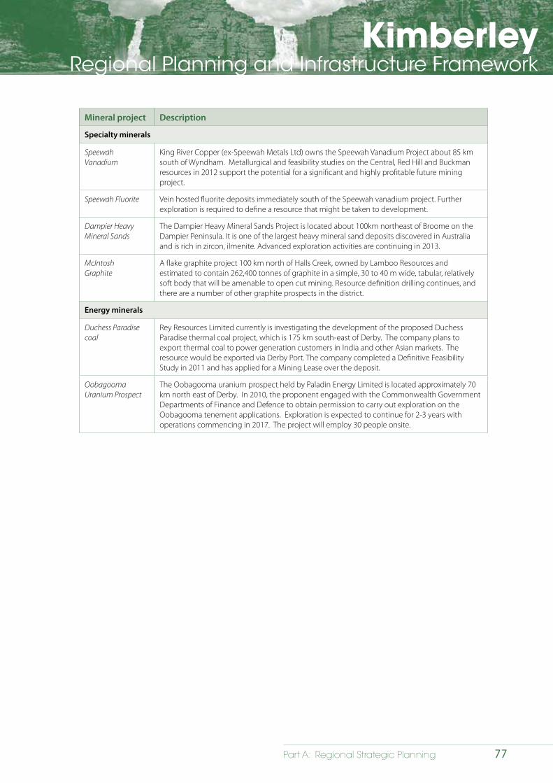
KimberleyRegional Planning and Infrastructure Framework
77Part A: Regional Strategic Planning
Mineral project Description
Specialty minerals
Speewah Vanadium
King River Copper (ex-Speewah Metals Ltd) owns the Speewah Vanadium Project about 85 km south of Wyndham. Metallurgical and feasibility studies on the Central, Red Hill and Buckman resources in 2012 support the potential for a significant and highly profitable future mining project.
Speewah Fluorite Vein hosted fluorite deposits immediately south of the Speewah vanadium project. Further exploration is required to define a resource that might be taken to development.
Dampier Heavy Mineral Sands
The Dampier Heavy Mineral Sands Project is located about 100km northeast of Broome on the Dampier Peninsula. It is one of the largest heavy mineral sand deposits discovered in Australia and is rich in zircon, ilmenite. Advanced exploration activities are continuing in 2013.
McIntosh Graphite
A flake graphite project 100 km north of Halls Creek, owned by Lamboo Resources and estimated to contain 262,400 tonnes of graphite in a simple, 30 to 40 m wide, tabular, relatively soft body that will be amenable to open cut mining. Resource definition drilling continues, and there are a number of other graphite prospects in the district.
Energy minerals
Duchess Paradise coal
Rey Resources Limited currently is investigating the development of the proposed Duchess Paradise thermal coal project, which is 175 km south-east of Derby. The company plans to export thermal coal to power generation customers in India and other Asian markets. The resource would be exported via Derby Port. The company completed a Definitive Feasibility Study in 2011 and has applied for a Mining Lease over the deposit.
Oobagooma Uranium Prospect
The Oobagooma uranium prospect held by Paladin Energy Limited is located approximately 70 km north east of Derby. In 2010, the proponent engaged with the Commonwealth Government Departments of Finance and Defence to obtain permission to carry out exploration on the Oobagooma tenement applications. Exploration is expected to continue for 2-3 years with operations commencing in 2017. The project will employ 30 people onsite.
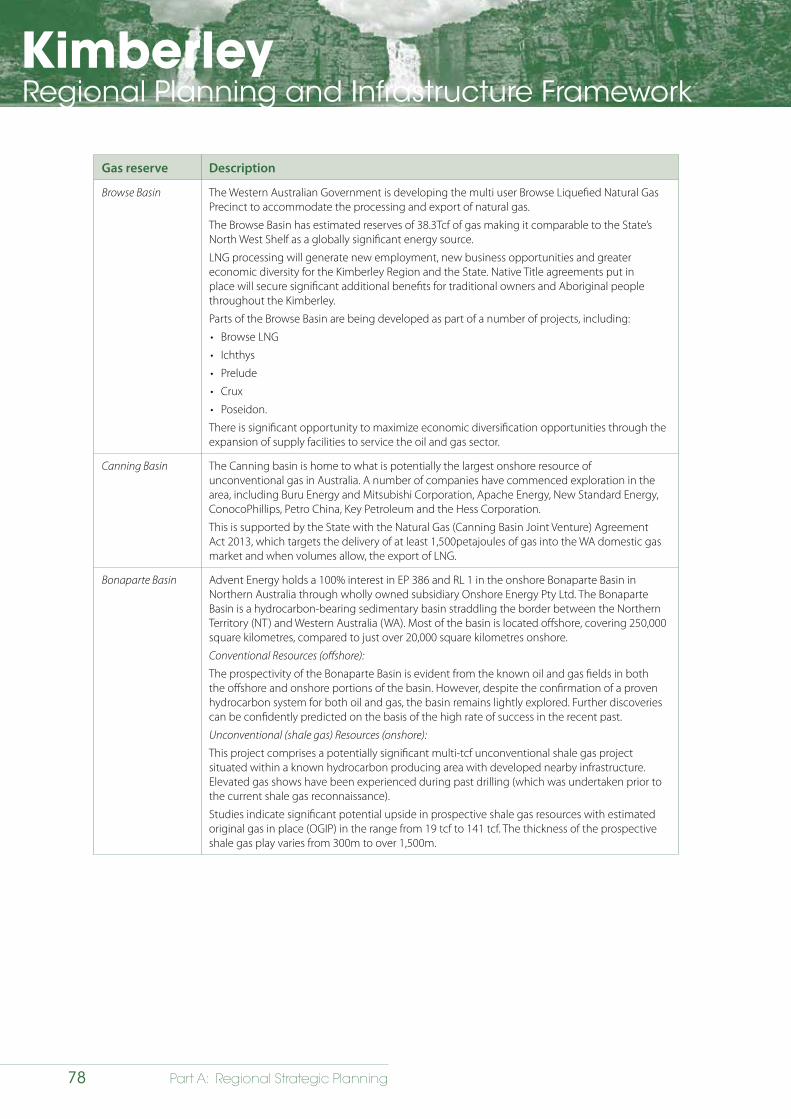
KimberleyRegional Planning and Infrastructure Framework
78 Part A: Regional Strategic Planning
Gas reserve Description
Browse Basin The Western Australian Government is developing the multi user Browse Liquefied Natural Gas Precinct to accommodate the processing and export of natural gas.
The Browse Basin has estimated reserves of 38.3Tcf of gas making it comparable to the State’s North West Shelf as a globally significant energy source.
LNG processing will generate new employment, new business opportunities and greater economic diversity for the Kimberley Region and the State. Native Title agreements put in place will secure significant additional benefits for traditional owners and Aboriginal people throughout the Kimberley.
Parts of the Browse Basin are being developed as part of a number of projects, including:
• Browse LNG
• Ichthys
• Prelude
• Crux
• Poseidon.
There is significant opportunity to maximize economic diversification opportunities through the expansion of supply facilities to service the oil and gas sector.
Canning Basin The Canning basin is home to what is potentially the largest onshore resource of unconventional gas in Australia. A number of companies have commenced exploration in the area, including Buru Energy and Mitsubishi Corporation, Apache Energy, New Standard Energy, ConocoPhillips, Petro China, Key Petroleum and the Hess Corporation.
This is supported by the State with the Natural Gas (Canning Basin Joint Venture) Agreement Act 2013, which targets the delivery of at least 1,500petajoules of gas into the WA domestic gas market and when volumes allow, the export of LNG.
Bonaparte Basin Advent Energy holds a 100% interest in EP 386 and RL 1 in the onshore Bonaparte Basin in Northern Australia through wholly owned subsidiary Onshore Energy Pty Ltd. The Bonaparte Basin is a hydrocarbon-bearing sedimentary basin straddling the border between the Northern Territory (NT) and Western Australia (WA). Most of the basin is located offshore, covering 250,000 square kilometres, compared to just over 20,000 square kilometres onshore.
Conventional Resources (offshore):
The prospectivity of the Bonaparte Basin is evident from the known oil and gas fields in both the offshore and onshore portions of the basin. However, despite the confirmation of a proven hydrocarbon system for both oil and gas, the basin remains lightly explored. Further discoveries can be confidently predicted on the basis of the high rate of success in the recent past.
Unconventional (shale gas) Resources (onshore):
This project comprises a potentially significant multi-tcf unconventional shale gas project situated within a known hydrocarbon producing area with developed nearby infrastructure. Elevated gas shows have been experienced during past drilling (which was undertaken prior to the current shale gas reconnaissance).
Studies indicate significant potential upside in prospective shale gas resources with estimated original gas in place (OGIP) in the range from 19 tcf to 141 tcf. The thickness of the prospective shale gas play varies from 300m to over 1,500m.
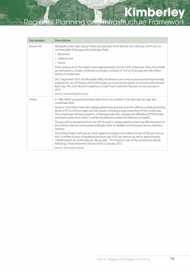
KimberleyRegional Planning and Infrastructure Framework
79Part A: Regional Strategic Planning
Gas project Description
Browse LNG Woodside is the major equity holder and operator of the Browse Joint Venture, which aims to commercialise three gas and condensate fields:
• Brecknock,
• Calliance and
• Torosa
These reserves lie in the Indian Ocean approximately 425 km north of Broome. These three fields are estimated to contain combined contingent volumes of 15.9 tcf of dry gas and 436 million barrels of condensate.
On 2 September 2013, the Woodside (WEL) led Browse Joint venture announced it had formally adopted the use of Floating LNG technologies as its processing option to commercialise Browse Basin Gas. The Joint Venture is seeking to make Final Investment Decision on the concept in 2015.(Source: www.woodside.com.au).
Ichthys In 1998, INPEX acquired the Ichthys field which has resulted in the discovery of a gas and condensate field.
Gas from the Ichthys Field will undergo preliminary processing at the offshore central processing facility (CPF) to remove water and raw liquids, including a large proportion of the condensate. This condensate will be pumped to a floating production, storage and offloading (FPSO) facility anchored nearby, from which it will be transferred to tankers for delivery to markets.
The gas will be transported from the CPF through a subsea pipeline more than 885 kilometres to the onshore LNG processing plant at Blaydin Point on Middle Arm Peninsula, Darwin, Northern Territory.
The Ichthys Project will have an initial capacity to produce 8.4 million tonnes of LNG per annum and 1.6 million tonnes of liquefied petroleum gas (LPG) per annum, as well as approximately 100,000 barrels of condensate per day at peak. The Project is now in the construction phase, following a Final Investment Decision (FID) in January 2012.(Source: www.inpex.com.au)
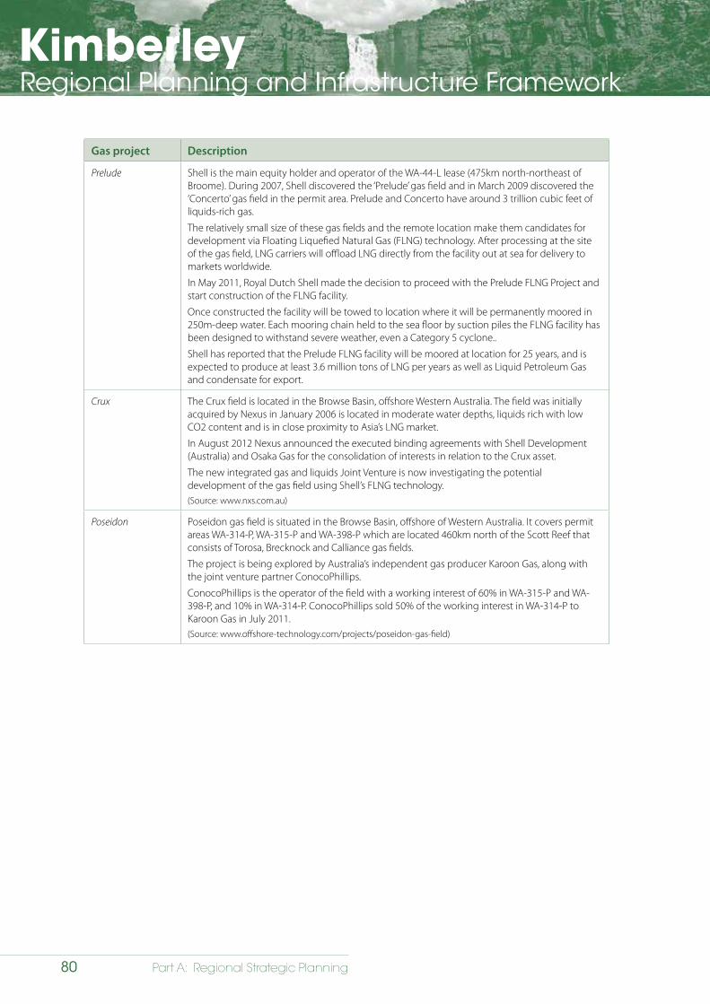
KimberleyRegional Planning and Infrastructure Framework
80 Part A: Regional Strategic Planning
Gas project Description
Prelude Shell is the main equity holder and operator of the WA-44-L lease (475km north-northeast of Broome). During 2007, Shell discovered the ‘Prelude’ gas field and in March 2009 discovered the ‘Concerto’ gas field in the permit area. Prelude and Concerto have around 3 trillion cubic feet of liquids-rich gas.
The relatively small size of these gas fields and the remote location make them candidates for development via Floating Liquefied Natural Gas (FLNG) technology. After processing at the site of the gas field, LNG carriers will offload LNG directly from the facility out at sea for delivery to markets worldwide.
In May 2011, Royal Dutch Shell made the decision to proceed with the Prelude FLNG Project and start construction of the FLNG facility.
Once constructed the facility will be towed to location where it will be permanently moored in 250m-deep water. Each mooring chain held to the sea floor by suction piles the FLNG facility has been designed to withstand severe weather, even a Category 5 cyclone..
Shell has reported that the Prelude FLNG facility will be moored at location for 25 years, and is expected to produce at least 3.6 million tons of LNG per years as well as Liquid Petroleum Gas and condensate for export.
Crux The Crux field is located in the Browse Basin, offshore Western Australia. The field was initially acquired by Nexus in January 2006 is located in moderate water depths, liquids rich with low CO2 content and is in close proximity to Asia’s LNG market.
In August 2012 Nexus announced the executed binding agreements with Shell Development (Australia) and Osaka Gas for the consolidation of interests in relation to the Crux asset.
The new integrated gas and liquids Joint Venture is now investigating the potential development of the gas field using Shell’s FLNG technology.(Source: www.nxs.com.au)
Poseidon Poseidon gas field is situated in the Browse Basin, offshore of Western Australia. It covers permit areas WA-314-P, WA-315-P and WA-398-P which are located 460km north of the Scott Reef that consists of Torosa, Brecknock and Calliance gas fields.
The project is being explored by Australia’s independent gas producer Karoon Gas, along with the joint venture partner ConocoPhillips.
ConocoPhillips is the operator of the field with a working interest of 60% in WA-315-P and WA-398-P, and 10% in WA-314-P. ConocoPhillips sold 50% of the working interest in WA-314-P to Karoon Gas in July 2011.(Source: www.offshore-technology.com/projects/poseidon-gas-field)
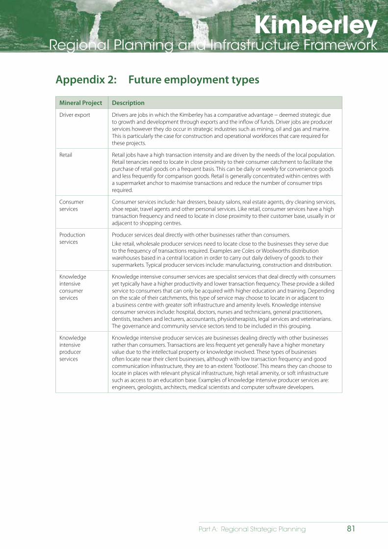
KimberleyRegional Planning and Infrastructure Framework
81Part A: Regional Strategic Planning
Appendix 2: Future employment types
Mineral Project Description
Driver export Drivers are jobs in which the Kimberley has a comparative advantage − deemed strategic due to growth and development through exports and the inflow of funds. Driver jobs are producer services however they do occur in strategic industries such as mining, oil and gas and marine. This is particularly the case for construction and operational workforces that care required for these projects.
Retail Retail jobs have a high transaction intensity and are driven by the needs of the local population. Retail tenancies need to locate in close proximity to their consumer catchment to facilitate the purchase of retail goods on a frequent basis. This can be daily or weekly for convenience goods and less frequently for comparison goods. Retail is generally concentrated within centres with a supermarket anchor to maximise transactions and reduce the number of consumer trips required.
Consumer services
Consumer services include: hair dressers, beauty salons, real estate agents, dry cleaning services, shoe repair, travel agents and other personal services. Like retail, consumer services have a high transaction frequency and need to locate in close proximity to their customer base, usually in or adjacent to shopping centres.
Production services
Producer services deal directly with other businesses rather than consumers.
Like retail, wholesale producer services need to locate close to the businesses they serve due to the frequency of transactions required. Examples are Coles or Woolworths distribution warehouses based in a central location in order to carry out daily delivery of goods to their supermarkets. Typical producer services include: manufacturing, construction and distribution.
Knowledge intensive consumerservices
Knowledge intensive consumer services are specialist services that deal directly with consumers yet typically have a higher productivity and lower transaction frequency. These provide a skilled service to consumers that can only be acquired with higher education and training. Depending on the scale of their catchments, this type of service may choose to locate in or adjacent to a business centre with greater soft infrastructure and amenity levels. Knowledge intensive consumer services include: hospital, doctors, nurses and technicians, general practitioners, dentists, teachers and lecturers, accountants, physiotherapists, legal services and veterinarians. The governance and community service sectors tend to be included in this grouping.
Knowledge intensive producer services
Knowledge intensive producer services are businesses dealing directly with other businesses rather than consumers. Transactions are less frequent yet generally have a higher monetary value due to the intellectual property or knowledge involved. These types of businesses often locate near their client businesses, although with low transaction frequency and good communication infrastructure, they are to an extent 'footloose'. This means they can choose to locate in places with relevant physical infrastructure, high retail amenity, or soft infrastructure such as access to an education base. Examples of knowledge intensive producer services are: engineers, geologists, architects, medical scientists and computer software developers.
KimberleyRegional Planning and Infrastructure Framework
82 Part A: Regional Strategic Planning
Appendix 3: Mining legislation
The Mining Act 1978 regulates mineral exploration and mining in the State through the grant and administration of various types of mining tenure and mining-related activities. It establishes the rights of access for exploration and mining purposes on different classes of land and the compensation provisions and royalties that apply.
The Western Australian Offshore Minerals Act 2003 regulates mineral exploration and mining within the area from the baseline (generally the mean low water mark) outward to three nautical miles of the territorial sea. Beyond this boundary, these activities in Australian waters are regulated by the Commonwealth Offshore Minerals Act 1994.
The Mines Safety and Inspection Act 1994 covers safety within commercial mining operations including quarries and mines that are not covered by the Mining Act 1978.
Activities in the petroleum, geothermal energy and greenhouse gas storage sectors are regulated by the following legislation:
The Petroleum and Geothermal Energy Resources Act 1967 covers all onshore areas of the State, including its islands and some waters landward of the base line, other than ‘subsisting’ permit areas under the Petroleum (Submerged Lands) Act, 1982.
The Western Australian Petroleum (Submerged Lands) Act 1982 applies to Western Australia’s terrestrial sea, including the territorial sea around the State islands, and under certain circumstances, some areas of internal waters.
The Commonwealth Offshore Petroleum and Greenhouse Gas Storage Act 2006 applies to the offshore areas of the continental shelf beyond the territorial sea boundary (at the three nautical mile mark).
Both the Petroleum and Geothermal Energy Act 1967 and the Petroleum (Submerged Lands) Act 1982 are administered solely by Western Australia, while the Commonwealth Petroleum and Greenhouse Gas Storage Act 2006 is administered by the National Offshore Petroleum Titles Administrator (NOPTA), which is part of the Commonwealth’s Department of Resources, Energy and Tourism (RET).”
State Agreements are legal contracts between the Western Australian Government and a proponent of a major project within the boundaries of Western Australia. State Agreements detail the rights, obligations, terms and conditions for the development of any specific project and establish a framework for ongoing relations and cooperation between the state and the project proponents. State Agreements have been used by successive governments since the 1950s to secure major resource projects, particularly those that require the development of railways and ports, and long-term titles and conditions. Under such agreements, proponents take or share responsibility with the state for developing infrastructure specific to the project.
KimberleyRegional Planning and Infrastructure Framework
83Part A: Regional Strategic Planning
List of acronyms
AAGR Average Annual Growth Rate
ABS Australian Bureau of Statistics
ADF Australian Defence Force
ADSL Asymmetric Digital Subscriber Line
AHA Aboriginal Heritage Act 1972
AHC Australian Heritage Council
ARCPS Aboriginal and Remote Communities Power Supply (Horizon Power)
ASGC Australian Standard Geographical Classification
BRM Basic Raw Materials
CAEPR Centre for Aboriginal Economic Policy Research
DAFWA Department of Agriculture and Food of Western Australia
DEC (former) Department of Environment and Conservation
DoE Department of Environment
DER Department of Environmental Regulation
DFS Department of Fire and Emergency Services
DoH Department of Housing
DIA Department of Indigenous Affairs
DoL Department of Lands
DMP Department of Mines and Petroleum
DPaW Department of Parks and Wildlife
DoP Department of Planning
DPC Department of Premier and Cabinet
DRD Department of Regional Development
DRDL (former) Department of Regional Development and Lands
DSD Department of State Development
DoW Department of Water
EDS Experience Development Strategy
EDWA Education Department of Western Australia
EPA Environmental Protection Authority
FFTP Fitzroy Futures Town Plan
FIFO Fly in / fly out
FLNG Floating Liquefied Natural Gas (processing)
GL gigalitre
KimberleyRegional Planning and Infrastructure Framework
84 Part A: Regional Strategic Planning
GL/yr gigalitre per year
GP General Practitioner
Ha hectares
ICC Infrastructure Coordinating Committee
ILUA Indigenous Land Use Agreements
IPA Indigenous Protection Areas
KAMSC Kimberley Aboriginal Medical Services Council
KDC Kimberley Development Commission
KLC Kimberley Land Council
kL kilolitres
kL/d kilolitres per day
km kilometre
KRPIF Kimberley Regional Planning and Infrastructure Framework
KRPC Kimberley Regional Planning Committee
KSCS Kimberley Science and Conservation Strategy
kV kilovolt
kWh kilowatt hours
LG local government
LIFO Live in / fly-out
LNG Liquefied Natural Gas
LPS Local Planning Strategy
LNG Liquefied Natural Gas
MRWA Main Roads Western Australia
Mtpa million tonnes per annum
MUNS Municipal Services program
MW mega watts
N&RCHS WA Northern & Remote Country Health Services Western Australia
NextG Next Generation Network (Telstra)
NPARIH National Partnership Agreement on Remote Indigenous Housing
NRM Natural Resource Management
NT Northern Territory
NTA Native Title Act 1993
ORIA Ord River Irrigation Area
ORIA2 Ord River Irrigation Area (Expansion 2)
ORIA3 Ord River Irrigation Area (Expansion 3)
pa per annum

KimberleyRegional Planning and Infrastructure Framework
85Part A: Regional Strategic Planning
PBC Prescribed Bodies Corporate
PJ petajoule
RAAF Royal Australian Air Force
RADS Regional Airports Development Scheme
RAESP Remote Area Essential Services Program
RMCP Regional Mobile Communications Project
RPIF Regional Planning and Infrastructure Framework
WARFNR Western Australian Regional Freight Network Review
SPP State Planning Policy
SPS State Planning Strategy
tcf trillion cubic feet
TEA Tidal Energy Australia
TWA Tourism Western Australia
TORG Traditional Owners Reference Group
TWWM Treated Waste Water Management
WA Western Australia
WAPC Western Australian Planning Commission
WWTP Waste Water Treatment Plant
SPP 2.4 State Planning Policy 2.4 - Basic Raw Materials
SPP 2.6 State Planning Policy 2.6 – State Coastal Planning Policy
SPP 3.2 State Planning Policy 3.2 - Aboriginal Settlements
SPP 3.5 State Planning Policy 3.5 - Historical Heritage Conservation
KimberleyRegional Planning and Infrastructure Framework
86 Part A: Regional Strategic Planning
KimberleyRegional Planning and Infrastructure Framework
87Part A: Regional Strategic Planning
References
AEC Group, 2012, Broome Economic Profile (draft) - March 2012, AEC Group.
AEC Group, 2012, Broome Community Profile (draft) - March 2012, AEC Group.
Anglo Australian Resources NL, 2011, mining within the Kimberley Region, Unpublished data, Anglo Australian Resources. Perth, WA.
Australian Bureau of Statistics, 2012, Census of Population and Housing: Basic Community Profile, Australian Bureau of Statistics, Canberra, ACT
Australian Bureau of Statistics, 2011, Census of Population and Households 2011, online databases – www.abs.wa.gov.au
Australian Bureau of Statistics, 2006, Census of Population and Housing: Basic Community Profile, Australian Bureau of Statistics, Canberra, ACT
Australian Bureau of Statistics, 2001, Census of Population and Housing: Basic Community Profile, Australian Bureau of Statistics, Canberra, ACT
Australian Defence Force, 2012, Australian Defence Force Posture Review, ADF, Canberra.
Bulletin Resources Limited, 2011, (www.bulletinresources.com) ‘Current mining activity in the Kimberley Region’. unpublished data. Bulletin Resources. Perth, WA
Chamber of Minerals and Energy Western Australia, 2011, State Outlook 2011, CMEWA, Perth.
Chamber of Minerals and Energy Western Australia, 2010, Policies, Planning and Partnerships for Responsible Resources Development in the Kimberley, CMEWA, Perth.
Christie, M J 1991, ‘Aboriginal Science for the Ecologically Sustainable Future’ in Australian Science Teachers Journal, vol. 37, no.1, March: 26 – 31, viewed 15 July 2011, via Academic Search Premier.
Davis, S., 2012, ‘Collaborative Land Use Planning and Development of Aboriginal Settlements in Western Australia: A Case Study’, unpublished symposium presentation organised by the Australian National University and Anthropological Society of Western Australia: Anthropology in the Aftermath of Native Title, University of Western Australia, Perth, WA.
Department for Communities, 2010, ‘Kimberley child and out of school hours care’ unpublished data, Department for Communities, Perth, WA.
Department for Sustainability, Environment, Water, Populations and Communities, 2012, Draft National Wildlife Corridors Plan, prepared by the National Wildlife Corridors Plan Advisory Group, ACT.
Department of Agriculture and Food, 2011, Land systems of the Kimberley region, Western Australia – Technical Paper 98 (www.dafwa.wa.gov.au), DAFWA, Perth.
Department of Education, 2011, Schools On Line - Kimberley school data: www.det.wa.edu.au/schoolsonline, Department of Education, Perth, WA.
Department of Education, Employment and Workplace Relations, 2012, Small Area Labour Markets, unpublished data, Department of Education, Employment and Workplace Relations. Perth, WA.
Department of Environment and Conservation, 2011, Kimberley Science and Conservation Strategy, DEC, Perth.
Department of Environment and Conservation, 2009, Protecting the Kimberley, a synthesis of scientific knowledge to support conservation management in the Kimberley region of Western Australia, DEC, Perth.
The Department of Fisheries, 2011, State of the Fisheries and Aquatic Resources Report 2010/11, Department of Fisheries, Perth, WA.
Department of Fisheries, 2011, ‘Fishing within the Kimberley Region.’ unpublished data. Department of Fisheries. Perth, WA.
Department of Health, 2011, ‘Kimberley hospital beds and inpatient mental health units’ unpublished data, Department of Health, Perth, WA.
KimberleyRegional Planning and Infrastructure Framework
88 Part A: Regional Strategic Planning
Department of Innovation, Industry, Science and Research, 2012, Indigenous Engagement with Science – towards deeper understanding, Inspiring Australia Indigenous Working Group, ACT.
Department of Regional Development and Lands/Kimberley Development Commission, 2011, Kimberley: Snapshot of a Region, DRDL/KDC, Perth, WA.
Department of Mines and Petroleum, 2011, Minerals and employment data (www.dmp.wa.gov.au) Department of Mines and Petroleum. Perth, WA.
Department of Planning and Infrastructure, 2004, How Traditional Owners of the North Kimberley want to look after their Country, prepared by the Kimberley Land Council, WA.
Department of State Development, 2012, Resource projects database – 2012’, DSD, Perth.
Department of State Development, 2010, ‘East Kimberley upgrades for existing health services’, unpublished data, Department of State Development, Perth, WA.
Department of State Development 2010, Strategic Environmental Assessment (including Social Impact Assessment) for the Browse Liquefied Natural Gas (LNG) Precinct. Perth, WA.
Department of Transport, 2012, Presentation to ICC/KRPC Joint Workshop on Kimberley Region Infrastructure Priorities, April 2012.
Department of Water, 2010, Draft Kimberley Region Water Plan, DOW, Perth.
Department of Water, 2013, Ord Surface Water Allocation Plan, DOW, Perth.
Donaldson, M. and Kenneally, K., (eds), 2007, Rock Art of the Kimberley - Proceedings of the Kimberley Society Rock Art Seminar, WA.
Education Department of Western Australia, 2012, Presentation to ICC/KRPC Joint Workshop on Kimberley Region Infrastructure Priorities, April 12 2012.
Ellison, C, 2009, Foundations for a Kimberley Strategy, Report on the consultation process for the Kimberley Science and Conservation Strategy, DEC, Perth.
Essential Environmental, 2011, Natural Resource Management Report for the Protection of Priority Natural Resources in the Kimberley Strategic Regional Land Use Plans – Report prepared for the Department of Planning, WA.
Gregory, J., and Gothard, J.,2009, Historical Encyclopaedia of Western Australia, University of Western Australia Press, Perth.
Government of Western Australia, 2007, State of the Environment Report, Perth, WA.
Health Department of Western Australia, 2012, Presentation to ICC/KRPC Joint Workshop on Kimberley Region Infrastructure Priorities, April 2012.
Horizon Power, 2012, Presentation to ICC/KRPC Joint Workshop on Kimberley Region Infrastructure Priorities, April 12 2012.
Horizon Power (2012) ‘Electricity infrastructure in the Kimberley’, unpublished data, Horizon Power. Perth, WA.
Kagara Limited, 2011, (www.kagara.com.au) ‘Mining activity in the Kimberley Region’, unpublished data, Kagara, Perth, WA.
Kimberley Development Commission/Department of Regional Development and Lands, 2011, Kimberley: A region in Profile, Perth, WA.
Kimberley Development Commission, 2013, Draft Kimberley Regional Investment Blueprint Stage 1, Kununurra and Broome, WA.
Kimberley Draft Regional Water Plan, 2010, ‘Strategic direction for water management in the Kimberley’ unpublished data, Perth, WA.
Kimberley Metals Group 2011 (www.kmetgroup.com) ‘Mining for KMG in Western Australia’ unpublished data, Perth, WA.
Kimberley Metals Group 2011 (www.kmetgroup.com) ‘Mining activity within Western Australia’ unpublished data, Perth, WA.
KimberleyRegional Planning and Infrastructure Framework
89Part A: Regional Strategic Planning
Kimberley Metals Limited 2011 (www.kimberleymetals.com.au) ‘Mining activity within Western Australia’ unpublished data, Perth, WA.
Kimberley TAFE, 2012, Strategic Plan 2010-2012, Kimberley TAFE, WA.
Main Roads Western Australia, 2012, Presentation to ICC/KRPC Joint Workshop on Kimberley Region Infrastructure Priorities, April 2012.
Meridian Minerals Limited, 2011, Meridian mining in Western Australia’ unpublished data, Meridian Minerals, Perth, WA.
Memmott, P. and Long, S., 2003, ‘Place Theory and Place Maintenance in Indigenous Australia’ in Urban Policy and Research, vol.20, no.1; 39-56, viewed 11 August 2011, via Academic Search Premier.
Memmott, P. 1980, ‘The Nature of Place’ in Man Environment Systems, vol.10, no.3/4, 160-168, viewed 10 August 2011, via Sage Publications.
New South Wales Heritage Office, 2004, Heritage and Sustainability – a Discussion Paper, NSW, Australia.
Niagra Regional Council, 2010, ‘Niagra Cultural Plan – Appendix 1’ in Cultural Mapping Summary Report, Canada.
North Kimberley Saltwater Country Steering Committee, 2010, North Kimberley Saltwater Country Plan for Balanggarra, Uunguu, Dambimangari and Mayala Saltwater Country, with assistance from The Kimberley Land Council, WA.
Paladin Energy Limited, 2011 ‘Mining within Western Australia’ unpublished data, Paladin Energy Limited, Perth, WA.
Panoramic Resources Ltd 2011 (www.panoramicresources.com) Mining activity in Western Australia. unpublished data, Panoramic Resources Perth, WA.
Reeves, D., 2005, Planning for Diversity, Routledge, London.
Renewable Energy Atlas of Australia, 2011, Images for the Kimberley Region, www.climatechange.gov.au.
Rey Resources 2011 (www.reyresources.com) ‘Mining within the Kimberley Region. unpublished data. Rey Resources. Perth, WA.
Rose, D. B 1996, Nourishing terrains: Australian Aboriginal views of landscape and wilderness, Canberra: Australian Heritage Commission.
Seddon, G., 1997, Words and weeds: some notes on language and landscape, in Landprints: Reflections on Place and Landscape, Cambridge University Press, Melbourne.
Speewah Metals Limited, 2012, (www.niplats.com.au) ‘Mining activity within the Kimberley Region’ unpublished data, Speewah Metals, Perth, WA.
Thundelarra Exploration Ltd, 2012, (www.thundelarra.com) ‘Kimberley mining activity’ unpublished data, Thundelarra, Perth, WA.
Tourism Resource Consultants Ltd, 2010, Kimberley National Landscape – Experience Development Strategy, ACT.
Tourism Western Australia, 2010, Australia’s North West: Tourism Development Priorities 2010- 2015, TWA, Perth.
Tourism Western Australia, 2011, Making a Difference – An Aboriginal Tourism Strategy for Western Australia 2011-2015, TWA, Perth.
Water Corporation, 2012 Presentation to ICC/KRPC Joint Workshop on Kimberley Region Infrastructure Priorities, April 2012.
Water Corporation, 2012 ‘Water and wastewater infrastructure in the Kimberley’, unpublished data, Water Corporation, 2012.
Water Corporation, 2010, ‘Water and wastewater services in the Kimberley’, unpublished data, Water Corporation. Perth, WA.
Water Corporation, 2009, ‘Water and wastewater services in the Kimberley’, unpublished data, Water Corporation. Perth, WA.
Western Australian Planning Commission, 2012, Draft State Planning Strategy, WAPC, Perth.
KimberleyRegional Planning and Infrastructure Framework
90 Part A: Regional Strategic Planning
Western Australian Planning Commission, 2012, Gascoyne Planning and Infrastructure Framework (draft), WAPC, Perth.
Western Australian Planning Commission, 2012, Mid-West Planning and Infrastructure Framework (draft), WAPC, Perth.
Western Australian Planning Commission, 2012, Pilbara Planning and Infrastructure Framework, WAPC, Perth.
Western Australian Planning Commission, 2012, Western Australia Tomorrow – Forecast Summary for Planning Regions, WAPC, Perth.
Western Australian Planning Commission, 2011, State Planning Policy 3.2 Aboriginal Settlements, Government of Western Australia.
Western Australian Planning Commission, 2009, Fitzroy Futures Town Plan, WAPC, Perth.
Western Australian Planning Commission, 2008, Halls Creek – regional hot spots land supply update, WAPC, Perth.
Western Australian Planning Commission, 2008, Fitzroy Crossing – regional hot spots land supply update, WAPC, Perth.
Western Australian Planning Commission, 2008, Derby – regional hot spots land supply update, WAPC, Perth.
Western Australian Planning Commission, 2008, Kununurra – regional hot spots land supply update, WAPC, Perth.
Western Australian Planning Commission, 2008, Broome – regional hot spots land supply update, WAPC, Perth.
Western Australian Planning Commission, 2007, State Planning Policy 3.5 Historic Heritage Conservation, Government of Western Australia.
Western Australian Planning Commission 2007, Visual Landscape Planning in Western Australia: a manual for evaluation, assessment, siting and design, Government of Western Australia.
Western Australian Planning Commission, 2006, State Planning Policy 3.4 – Natural Hazards and Disasters, Government of Western Australia.
Western Australian Planning Commission, 2006, State Planning Policy 2.6 – State Coastal Planning Policy, Government of Western Australia.
Western Australian Planning Commission, 2006, State Planning Policy 1 – State Planning Framework Policy, Government of Western Australia.
Western Australian Planning Commission, 2003, State Planning Policy 2 Environment and Natural Resources, Government of Western Australia.
Western Australian Planning Commission, 2000, State Planning Policy 2.4 Basic Raw Materials, Government of Western Australia.
Western Australian Police Department, 2012, ‘Kimberley Police Services’ unpublished data, Department of Police, Perth, WA.
Williams, D R 2008, ‘Pluralities of Place: A User’s Guide to Place Concepts, Theories, and Philosophies in Natural Resource Management’, in Kruger, L E, Hall, T E & Stiefel, M C (eds) Understanding Concepts of Place in Recreation Research and Management, Portland, Otegon: U.S. department of Agriculture, forest Service, Pacific Northwest Research Station.
Williams, D R & Stewart, S 1998, ‘Sense of place: an elusive concept that is finding a home in ecosystem management’ in Journal of Forestry. vol. 96, no. 5: 18 – 23, viewed 12 August 2011, via Google Scholar.
Local government websites
Shire of Broome: www.broome.wa.gov.au
Shire of Derby West Kimberley: www.sdwk.wa.gov.au
Shire of Halls Creek: www.hallscreek.wa.gov.au
Shire of Wyndham East Kimberley: www.swek.wa.gov.au