part 6 weathering of carbonate rock. limestone commonly weathers to a bluish- grey color, as shown...
Post on 21-Dec-2015
223 views
TRANSCRIPT

Part 6Part 6
WEATHERING WEATHERING
OFOF CARBONATE CARBONATE
ROCKROCK

Limestone commonly weathers to a bluish-Limestone commonly weathers to a bluish-grey color, as shown here, center-left of photo. grey color, as shown here, center-left of photo. McCloud River arm of Lake Shasta, CA McCloud River arm of Lake Shasta, CA

Carbonic acidCarbonic acid from rainwater and water from rainwater and water percolating through decaying forest liter percolating through decaying forest liter weathers weathers feldsparfeldspar and and calcitecalcite

Carbonate rocksCarbonate rocks are more susceptible to solutioning are more susceptible to solutioning and enlargement of discontinuities, especially along and enlargement of discontinuities, especially along orthogonal joints and bedding planes. orthogonal joints and bedding planes.
In the Midwest, In the Midwest, rainwaterrainwater can dissolve 1 mm of can dissolve 1 mm of limestone in 25 years where there is an average limestone in 25 years where there is an average precipitation of 34 in/yr (Winkler, 1965).precipitation of 34 in/yr (Winkler, 1965).

Terra rossa residual soils forming over limestone, Terra rossa residual soils forming over limestone, typical of sub-humid conditions. Note how the typical of sub-humid conditions. Note how the reddish-brown soil infills the joints and separations reddish-brown soil infills the joints and separations between core stones. Tree roots often follow these. between core stones. Tree roots often follow these.

Distinctly weathered surface of carbonate rock known as Distinctly weathered surface of carbonate rock known as "rillenkarren,“"rillenkarren,“ small solution pockets a few centimeters apart small solution pockets a few centimeters apart separated by sharp intergroove crests. These are formed by separated by sharp intergroove crests. These are formed by solutioning of puddled rain drops, which are slightly acidic.solutioning of puddled rain drops, which are slightly acidic.

GEOFORENSICSGEOFORENSICS Geoforensics Geoforensics involves involves
principles of geology to principles of geology to solve various mysteries solve various mysteries involving earth and ocean involving earth and ocean systems. These include systems. These include applications to engineering applications to engineering failures as well as crimes failures as well as crimes involving our criminal involving our criminal justice system. justice system.
The background in this The background in this photo of Osama bin Laden photo of Osama bin Laden appears to be a type of appears to be a type of karst feature called karst feature called rillenkarrenrillenkarren. Not rare, but . Not rare, but not that common either.not that common either.
Osama bin Laden giving interview Osama bin Laden giving interview aired on al Jazeera television in aired on al Jazeera television in November 2001; likely somewhere in November 2001; likely somewhere in the Tora Bora Mountains of the Tora Bora Mountains of Afghanistan.Afghanistan.

Karst Karst refers the topography typically developed on limestone, refers the topography typically developed on limestone, gypsum and other soluble rocks, primarily by dissolution. gypsum and other soluble rocks, primarily by dissolution. Karst Karst regionsregions are typified by are typified by sinkholes, cave, dry channelssinkholes, cave, dry channels and and extensive extensive underground drainage networksunderground drainage networks, most of which are , most of which are joint-controlled. joint-controlled.
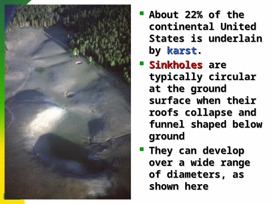
About 22% of the About 22% of the continental United continental United States is underlain by States is underlain by karstkarst..
SinkholesSinkholes are typically are typically circular at the ground circular at the ground surface when their surface when their roofs collapse and roofs collapse and funnel shaped below funnel shaped below groundground
They can develop over They can develop over a wide range of a wide range of diameters, as shown diameters, as shown here here

1981 Auburndale, FL depression resulted from oxidation 1981 Auburndale, FL depression resulted from oxidation of peats deposited in an underlying sinkhole. The of peats deposited in an underlying sinkhole. The depression was about 2 ft deep.depression was about 2 ft deep.

Engineering geologists surveying ground fissures Engineering geologists surveying ground fissures caused by settlement.caused by settlement. Sinkhole features generally Sinkhole features generally express themselves in circular form.express themselves in circular form.

A 1981 drought in Florida caused the collapse of this A 1981 drought in Florida caused the collapse of this 320 ft wide by 100 ft deep sinkhole in Winter Park, 320 ft wide by 100 ft deep sinkhole in Winter Park, FloridaFlorida

Ground view of the May 1981 sinkhole in Winter Park, Ground view of the May 1981 sinkhole in Winter Park, Florida. Note the funnel shape of the deep, central Florida. Note the funnel shape of the deep, central abyss.abyss.

Approximately 22% of the Continental United States is Approximately 22% of the Continental United States is underlain by karst, including most of the Ozarks. This is a underlain by karst, including most of the Ozarks. This is a large sinkhole feature known as large sinkhole feature known as Slaughter SinkSlaughter Sink, near , near Interstate 44 on the Phelps/Pulaski County boundary.Interstate 44 on the Phelps/Pulaski County boundary.

Most Most limestone cavernslimestone caverns begin through begin through solution of calcite along steeply dipping rock solution of calcite along steeply dipping rock joints and faultsjoints and faults
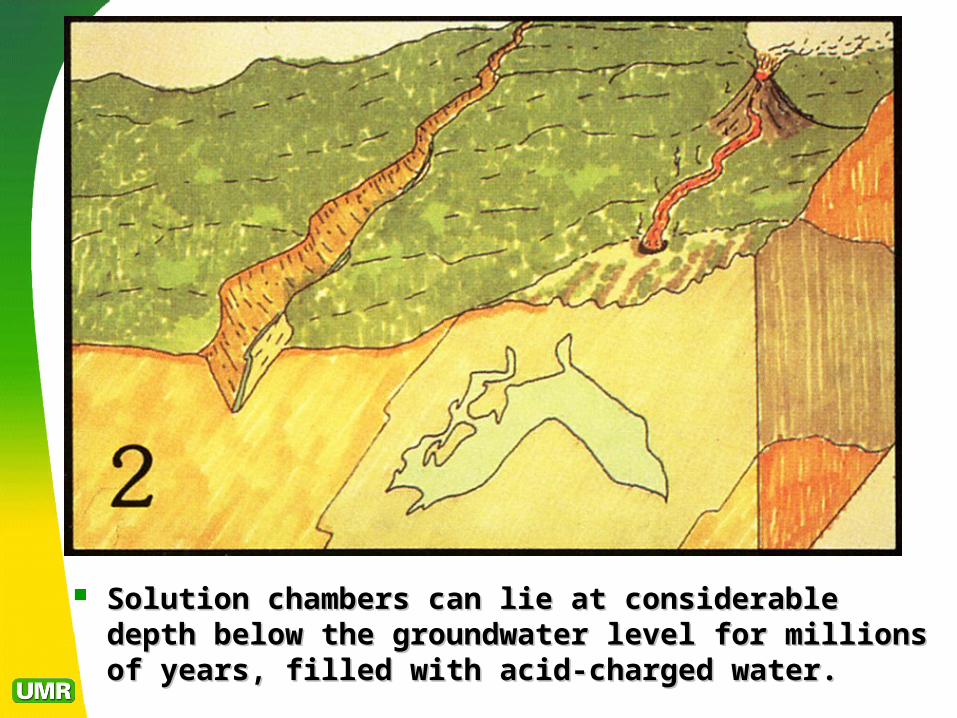
Solution chambers can lie at considerable depth Solution chambers can lie at considerable depth below the groundwater level for millions of years, below the groundwater level for millions of years, filled with acid-charged water.filled with acid-charged water.

Shifts in weather patterns or natural erosion Shifts in weather patterns or natural erosion can serve to lower groundwater levels, can serve to lower groundwater levels, removing buoyancy and support, causing removing buoyancy and support, causing partial collapsepartial collapse. .

Continued solution can open up pathways to the Continued solution can open up pathways to the atmosphere, allowing calcite-bearing solutions to enter atmosphere, allowing calcite-bearing solutions to enter the cavern, lose some of their dissolved COthe cavern, lose some of their dissolved CO22 and and deposit calcite as deposit calcite as speleothemsspeleothems. . Residual clayResidual clay begins to begins to fill the interstices of the cavern floor.fill the interstices of the cavern floor.

During the wetter climes of the Pleistocene calcite-During the wetter climes of the Pleistocene calcite-rich groundwater deposited speleothems and washed rich groundwater deposited speleothems and washed out some portion of the residual clay.out some portion of the residual clay.
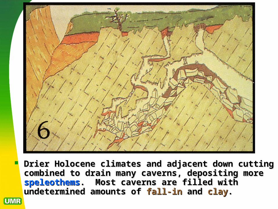
Drier Holocene climates and adjacent down cutting Drier Holocene climates and adjacent down cutting combined to drain many caverns, depositing more combined to drain many caverns, depositing more speleothemsspeleothems. Most caverns are filled with undetermined . Most caverns are filled with undetermined amounts of amounts of fall-infall-in and and clayclay. .