part-2 projections and proposals prepared by …
TRANSCRIPT
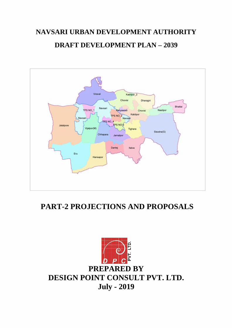
NAVSARI URBAN DEVELOPMENT AUTHORITY
DRAFT DEVELOPMENT PLAN – 2039
PART-2 PROJECTIONS AND PROPOSALS
PREPARED BY
DESIGN POINT CONSULT PVT. LTD.
July - 2019
Navsari Urban Development Authority, Navsari Page 1
Contents List of Figure ............................................................................................................................ 5
List of Tables ............................................................................................................................ 6
List of Charts ............................................................................................................................ 6
1. Introduction .......................................................................................................................... 7
1.1 Growth pattern and trends ................................................................................................ 7
1.2 Population projections ...................................................................................................... 8
1.3 Suggestions from stakeholders ......................................................................................... 8
1.4 Vision and Concepts of Growth management.................................................................. 9
Chapter 2 Vision for Development of NUDA ...................................................................... 10
2.1 Vision ............................................................................................................................. 10
2.2 Concepts for Development Planning and Growth Management .................................... 10
2.3 Development Framework ............................................................................................... 11
2.4 Considerations for proposed plans, proposals and recommendations............................ 11
Chapter 3 Zoning and Development .................................................................................... 13
3.1 Introduction .................................................................................................................... 13
3.2 Considerations for Proposals .......................................................................................... 13
3.3 Proposed Landuse .......................................................................................................... 14
3.3 Proposals and Recommendations ................................................................................... 16
3.3.1. Proposal 1: Re-densification of Existing zoned areas ............................................ 16
3.3.2 Proposal 2: Preservation of Agriculture Zone to preserve agriculture land ............ 17
3.4 Recommended actions for implementation .................................................................... 18
Chapter 4 Transportation and Road Network .................................................................... 19
4.1 Introduction .................................................................................................................... 19
4.2 Considerations ................................................................................................................ 19
Proposals and Recommendations ......................................................................................... 21
4.3 Proposal 1: Simplified, Unified Street Classification system ........................................ 21
4.4 Proposal 2: Expansion of Road Network ....................................................................... 24
4.5 Proposal 3: Network Improvement ................................................................................ 25
4.6 Proposal 4: Pedestrian Network ..................................................................................... 26
4.7 Proposal 5: Parking Management .................................................................................. 27
4.8 Proposal 6: Decentralization of GSRTC Depots ............................................................ 29
4.9 Recommended Actions for Implementations ................................................................. 30
Navsari Urban Development Authority, Navsari Page 2
Chapter 5 Green Network ..................................................................................................... 32
5.1 Introduction .................................................................................................................... 32
5.2 Considerations ................................................................................................................ 32
Proposals and Recommendations ......................................................................................... 32
5.3 Proposal 1: Green Street Network .................................................................................. 33
5.4 Proposal 2: Waterfront Development ............................................................................. 34
5.5 Proposal 5: Recreational area around Water body ......................................................... 35
5.5 Recommendations .......................................................................................................... 36
5.6 Recommended actions for implementation .................................................................... 37
Chapter 6 Physical Infrastructure ....................................................................................... 38
6.1 Water Supply .................................................................................................................. 38
6.1.1 Basic Considerations –water supply ........................................................................ 38
6.1.2 Proposals & Recommendations: .............................................................................. 38
6.2 Sewerage ........................................................................................................................ 39
6.2.1 Basic considerations– Sewerage .............................................................................. 39
6.2.2 Proposals and Recommendations ............................................................................ 40
6.3 Storm Water System....................................................................................................... 40
6.3.1 Basic Considerations – storm water ........................................................................ 40
6.3.2 Proposals and Recommendations ............................................................................ 41
6.4 Solid waste management ................................................................................................ 41
6.4.1 Basic Considerations –solid waste management ..................................................... 42
6.4.2 Proposals and Recommendations ............................................................................ 42
6.5 Recommendations for implementation .......................................................................... 42
Chapter 7 Social Infrastructure ........................................................................................... 43
7.1 Proposals ........................................................................................................................ 43
7.2 Recommendations .......................................................................................................... 44
Chapter 8 Economic Development ....................................................................................... 45
8.1 Considerations ................................................................................................................ 45
8.2 Proposals and Recommendations ................................................................................... 45
8.3 Recommended Actions for implementation ................................................................... 47
9.1 Considerations ................................................................................................................ 50
9.2 Proposals and Recommendations ................................................................................... 50
9.3 Recommended Actions for implementation ................................................................... 51
Navsari Urban Development Authority, Navsari Page 3
Chapter 10 Environment ....................................................................................................... 52
10.1 Considerations .............................................................................................................. 52
10.2 Proposals and Recommendations ................................................................................. 52
10.2.1 Incentivizing Green development .......................................................................... 52
10.2.2 Water Quality and water resource management: ................................................... 52
10.2.3 Air Quality ............................................................................................................. 53
10.2.4 Noise ...................................................................................................................... 54
10.3 Recommended Actions for implementation ................................................................. 55
Chapter 11 Implementation of Development Plan ............................................................. 56
11.1 Introduction .................................................................................................................. 56
11.2 Implementation Tools .................................................................................................. 56
11.2.1 Comprehensive General Development Control Regulations (CGDCR) ............... 56
11.2.2 Projects .................................................................................................................. 58
11.2.3 Proposals ................................................................................................................ 58
11.2.4 Detailed Plans, Studies and other improvements .................................................. 59
11.2.5 Creation of Resource Cell...................................................................................... 60
11.3 Implementation Mechanisms ....................................................................................... 60
Chapter 12 Costing and Resource Mobilization ................................................................. 61
12.1 Cost Estimation ............................................................................................................ 61
12.1.1 Implementation of projects (Construction and Development) .............................. 61
12.1.2 Preparation of detailed plans and studies .............................................................. 66
12.1.3 Database Preparation and procedural changes ...................................................... 66
12.1.4 Resource cell .......................................................................................................... 66
12.1.5 Total cost for Revised Draft Development Plan .................................................... 66
12.2 Resource Mobilization ................................................................................................. 66
12.2.1 Self-funding by Authority ..................................................................................... 67
12.2.2 Funding from State Government ........................................................................... 67
12.2.3 Funding from Central Government ....................................................................... 67
12.2.4 Leveraging funding from other agencies and departments ................................... 67
12.2.5 Joint Ventures/Public Private Partnership (PPP) ................................................... 67
Chapter 13 Recommended Actions ...................................................................................... 68
13.1 Projects ......................................................................................................................... 68
13.2 Implementation of Proposals ........................................................................................ 68
Navsari Urban Development Authority, Navsari Page 4
13.3 Preparation of Detailed Plans, studies and other improvements .................................. 68
13.4 Creation of Resource Cell ............................................................................................ 69
APPENDIX .............................................................................................................................. 71
APPENDIX 1.A – BASIS FOR POPULATION PROJECTIONS ........................................ 71
PROJECTION METHODOLOGY ..................................................................................... 71
APPENDIX 3.2. A – NETWORK ROAD PLANNING ...................................................... 72
Navsari Urban Development Authority, Navsari Page 5
List of Figure
Figure 1 Growth Pattern of Navsari ........................................................................................... 7
Figure 2 Schematic Diagram for adopting concepts ................................................................ 10
Figure 3 Proposed Landuse ...................................................................................................... 15
Figure 4 Proposed Agriculture Zone........................................................................................ 17
Figure 5 High Speed Rail Corridor .......................................................................................... 20
Figure 6 Proposed Road Pattern in NUDA Area ..................................................................... 22
Figure 7 Sectional Diagram of Major Arterial Road ............................................................... 22
Figure 8 Sectional Diagram of Minor Arterial Road ............................................................... 23
Figure 9 Sectional Diagram of Major Streets .......................................................................... 23
Figure 10 Sectional Diagram of Minor Streets ........................................................................ 24
Figure 11 Hierarchy of Transportation Users .......................................................................... 27
Figure 12 Existing on street Parking ........................................................................................ 28
Figure 13 Existing GSRTC Depots.......................................................................................... 30
Figure 14 Examples of Green shaded Pedestrian Street and landscaped street ....................... 33
Figure 15 Envisioning Green Street Development .................................................................. 34
Figure 16 Illustration: Envisioning Lake Development.......................................................... 35
Figure 17 Proposed Recreational space around water boadies ................................................ 36
Figure 18 Proposed STP Station ............................................................................................. 40
Figure 19 "Kirti Pillar" at Dandi Beach ................................................................................... 48
Figure 20 Dudhiya Talav ......................................................................................................... 48
Figure 21 Dastur Meherji-Rana Library .................................................................................. 49
Figure 22 Dharagiri Falls ......................................................................................................... 49
Figure 23 Tapodhan Dham ...................................................................................................... 49
Figure 24 Dargah of Sayed Saadat........................................................................................... 49
Figure 25 Lunsikui area ........................................................................................................... 50
Navsari Urban Development Authority, Navsari Page 6
List of Tables
Table 1 Population Detail .......................................................................................................... 8
Table 2: Growth Rate Percentage Increase .............................................................................. 14
Table 3: Area Table of Proposed Land Use 2039 .................................................................... 15
Table 4 Number of Proposed Bridges in Navsari Municipality and NUDA ........................... 26
Table 5 Demand analysis of Water Supply.............................................................................. 38
Table 6 Cost break up for Construction of Roads ................................................................... 61
Table 7 Estimation of Drainage Work ..................................................................................... 63
List of Charts Chart 1 Population projection– NUDA...................................................................................... 8
Chart 2: Population Growth Rate with Projection ................................................................... 14
Chart 3 Proposed Land Use 2039 ............................................................................................ 16
Chart 4 Road/Street Classification by ROW .......................................................................... 21
Navsari Urban Development Authority, Navsari Page 7
1. Introduction The Draft Development Plan, 2039 is prepared considering the demand of projected population
of next two decades for the entire area of 71.36 Sq.km of Navsari Urban Development
Authority (NUDA). This total area consists of Navsari Municipal Corporation (NMC) Area
and rest of villages under NUDA. Total 18 villages are included under over all NUDA.
Navsari is one of the most important, rapid growing industrial centres for small scale industries
in this region. As well it is the centre for social, cultural, commercial, educational, political and
industrial activities. It is one of the important economic centre in South Gujarat region after
Surat, on Ahmedabad-Mumbai Golden Corridor. The new developmental forces and activities
that were in vogue in the region during the last four decades have posted a challenging problem
to the architects and planners while creating manmade environments within the domain of the
natural landscape that the region offers.
Going forward, in a globalizing scenario, the role of the city is even more pronounced.
Ultimately, if Navsari is to improve as quality of life and sustainable place with affordable
costs, short commutes, low travel times and sufficient amenities, it must plan with necessary
foundations and organize its land resources carefully.
Following are some of the major considerations taken into account for deriving and formulating
proposals of the Draft Development Plan 2039.
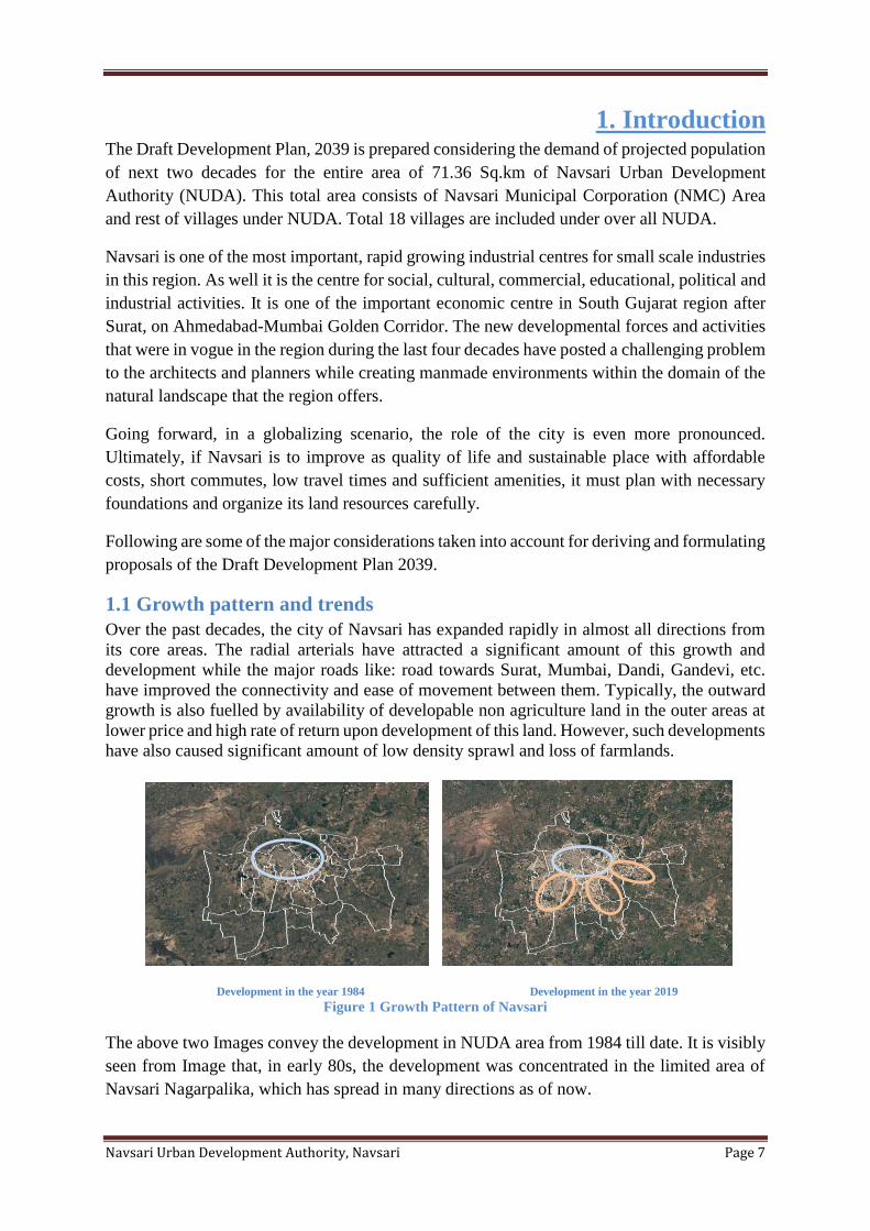
1.1 Growth pattern and trends
Over the past decades, the city of Navsari has expanded rapidly in almost all directions from
its core areas. The radial arterials have attracted a significant amount of this growth and
development while the major roads like: road towards Surat, Mumbai, Dandi, Gandevi, etc.
have improved the connectivity and ease of movement between them. Typically, the outward
growth is also fuelled by availability of developable non agriculture land in the outer areas at
lower price and high rate of return upon development of this land. However, such developments
have also caused significant amount of low density sprawl and loss of farmlands.
Development in the year 1984 Development in the year 2019
Figure 1 Growth Pattern of Navsari
The above two Images convey the development in NUDA area from 1984 till date. It is visibly
seen from Image that, in early 80s, the development was concentrated in the limited area of
Navsari Nagarpalika, which has spread in many directions as of now.
Navsari Urban Development Authority, Navsari Page 8
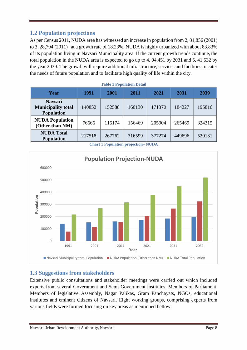
1.2 Population projections
As per Census 2011, NUDA area has witnessed an increase in population from 2, 81,856 (2001)
to 3, 28,794 (2011) at a growth rate of 18.23%. NUDA is highly urbanized with about 83.83%
of its population living in Navsari Municipality area. If the current growth trends continue, the
total population in the NUDA area is expected to go up to 4, 94,451 by 2031 and 5, 41,532 by
the year 2039. The growth will require additional infrastructure, services and facilities to cater
the needs of future population and to facilitate high quality of life within the city.
Table 1 Population Detail
Year 1991 2001 2011 2021 2031 2039
Navsari
Municipality total
Population
140852 152588 160130 171370 184227 195816
NUDA Population
(Other than NM) 76666 115174 156469 205904 265469 324315
NUDA Total
Population 217518 267762 316599 377274 449696 520131
Chart 1 Population projection– NUDA
1.3 Suggestions from stakeholders
Extensive public consultations and stakeholder meetings were carried out which included
experts from several Government and Semi Government institutes, Members of Parliament,
Members of legislative Assembly, Nagar Palikas, Gram Panchayats, NGOs, educational
institutes and eminent citizens of Navsari. Eight working groups, comprising experts from
various fields were formed focusing on key areas as mentioned bellow.
0
100000
200000
300000
400000
500000
600000
1991 2001 2011 2021 2031 2039
Po
pu
lati
on
Year
Population Projection-NUDA
Navsari Municipality total Population NUDA Population (Other than NM) NUDA Total Population
Navsari Urban Development Authority, Navsari Page 9
(1) Regional Structure
(2) Traffic and Transportation
(3) Demography and Economic Studies
(4) Environmental Sustainability and Disaster Management
(5) Real estate, Housing and Land value
(6) Informal sectors and Slums
(7) Urban infrastructure
(8) GDCR
The inputs from the consultation were studied and reviewed, detailed analysis of existing
situation was conducted and proposals and policies for the Development Plan were formulated
based on the inferences.
1.4 Vision and Concepts of Growth management
The vision and the principles identified after multiple discussions and deliberations played a
crucial role in formulating the proposals of this Development Plan. The major concepts that
shaped the proposals include environment friendly and responsive planning, co‐ordination
between land use and transport through transit oriented development, creating harmonious
open spaces, encouraging sustainable and affordable development.
Navsari Urban Development Authority, Navsari Page 10
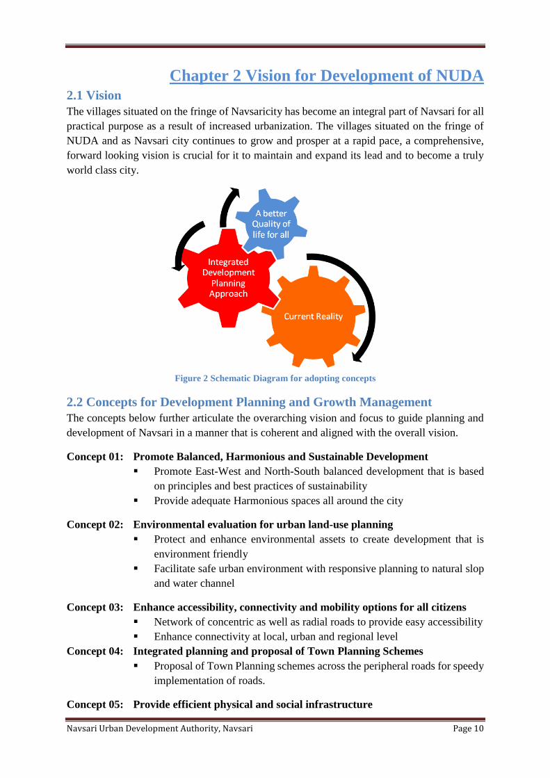
Chapter 2 Vision for Development of NUDA 2.1 Vision
The villages situated on the fringe of Navsaricity has become an integral part of Navsari for all
practical purpose as a result of increased urbanization. The villages situated on the fringe of
NUDA and as Navsari city continues to grow and prosper at a rapid pace, a comprehensive,
forward looking vision is crucial for it to maintain and expand its lead and to become a truly
world class city.
Figure 2 Schematic Diagram for adopting concepts
2.2 Concepts for Development Planning and Growth Management
The concepts below further articulate the overarching vision and focus to guide planning and
development of Navsari in a manner that is coherent and aligned with the overall vision.
Concept 01: Promote Balanced, Harmonious and Sustainable Development
▪ Promote East-West and North-South balanced development that is based
on principles and best practices of sustainability
▪ Provide adequate Harmonious spaces all around the city
Concept 02: Environmental evaluation for urban land-use planning
▪ Protect and enhance environmental assets to create development that is
environment friendly
▪ Facilitate safe urban environment with responsive planning to natural slop
and water channel
Concept 03: Enhance accessibility, connectivity and mobility options for all citizens
▪ Network of concentric as well as radial roads to provide easy accessibility
▪ Enhance connectivity at local, urban and regional level
Concept 04: Integrated planning and proposal of Town Planning Schemes
▪ Proposal of Town Planning schemes across the peripheral roads for speedy
implementation of roads.
Concept 05: Provide efficient physical and social infrastructure
Navsari Urban Development Authority, Navsari Page 11
▪ Proposal of Utility corridors across all the roads to provide efficient and
adequate physical infrastructure
▪ Provide social infrastructure that supports the needs of developed areas
Concept 06: Proposals of special development areas
▪ Plan and develop special area within the city that contain various use along
with adequate gardens, parks and open spaces
▪ Lakes Development, Dandi road etc.
Concept 07: Facilitate vibrant, lively, and safe urban environment
▪ Facilitate the creation of vibrate, and lively urban environments by
encouraging consistent and coordinated development regulations
▪ Facilitate safe urban environment to people
2.3 Development Framework
The current city form of Navsari has been evolved over past decades. This street network has
shaped the nature and form of development that has taken place within the city. The general
development pattern in the city has followed typical density patterns with concentration of
highest density in the central areas, gradually reducing towards the periphery. Analyzing the
existing development, it is relatively moderate density and primarily low rise urban form with
scattered sprawl on outer fringes.
The urban framework in the Draft Development Plan 2039 aims to build upon the vision and
the principles to guide the urban form of the city so that development continues and urban
infrastructure is optimized. Increase in density is proposed through introduction of telescopic
FSI and transit oriented zones which can help facilitate densification and redevelopment in
existing areas.
Higher densities are proposed along public transport corridors to facilitate transport, reduce
congestion, reduce dependability on private transport and optimize investments in transport
infrastructure. This will help define characters of the different neighborhoods, thereby
improving and enhancing the image ability and legibility of the city.
2.4 Considerations for proposed plans, proposals and recommendations
The proposals and recommendations from the main core of this Revised Draft Comprehensive
Development Plan 2039. They are formulated after multiple deliberations, detailed analysis of
existing conditions, future growth projections, the overarching vision, the principles and the
input from stakeholders all combined. Even though many of these proposals cover more than
one focus area, for ease of organizing they are grouped under nine subsections which are as
follows
1. Zoning and Development
2. Transport Network and Mobility
3. Housing
4. Green Network
5. Physical infrastructure
Navsari Urban Development Authority, Navsari Page 12
6. Social infrastructure
7. Economic development
8. Heritage
9. Environment
Generally, proposals are the proposed tasks that are to be carried out or implemented primarily
by the Authority. Whereas recommendations include the ‘tasks’ or actions for which other
government departments or entities may have to take primary role, with the authority
supporting them.
Navsari Urban Development Authority, Navsari Page 13
Chapter 3 Zoning and Development 3.1 Introduction
Today, the areas within NUDA limits are home of about 3.16 lakhs people. As this number
continues to grow and the city continues to prosper, additional supply of land and built spaces
will be required to provide places for living, working, shopping, education, entertainment,
healthcare, gardens, infrastructure and many such needs. Also, it would be crucial to organize
this growth in a manner that maintains the quality of life and livability standards within the
area while keeping it economically vibrant and environmentally sustainable. This development
plan aims to satisfy these needs through various tools and mechanisms available under the
existing legal frameworks and in a manner that inconsistent with the overarching vision and
principles of this plan.
Zoning is one of the important planning tools to manage growth, regulate density and organize
land uses within the urban area. By regulating land uses it helps to segregate incompatible uses,
increase livability and create desirable character for different areas for the city. Zoning
combined with development regulations determines the supply of developable land and built
space in various zones. However, before arriving at various proposals to accommodate growth
and organize land uses, it is important to first understand the demand for development and
various considerations to organize land use and densities.
3.2 Considerations for Proposals
It is important to understand following considerations that were taken into account while
deriving and formulating proposals included in this section.
▪ Existing Growth pattern and trend
▪ Population projections for 2031 and 2039
▪ Comprehensive assessment of existing conditions, land uses, development
typologies, socio‐economic parameters etc.
▪ Existing supply of buildable land in zoned areas
▪ Availability of land suitable for urbanization
▪ The overarching vision for Navsari 2039, the planning and growth management
principles including growth rate, transport network, sustainable environment and
affordable development
▪ Study of State and Central Government policies and working group reports such as
integrated mobility plan, City Development Plan (CDP), Tourism policy, Heritage
policy, Hospital policy, slum redevelopment and rehabilitation population, etc.
▪ Incorporation of comments and suggestions from Working group and stakeholder
meetings
Assessing Future Demand and Existing Supply:
Estimating demand for development is crucial to understand how much of additional zoned
land will be required to accommodate growth in the coming decades. Currently, NUDA area is
home of about 3,16599 people (According to 2011 Census). This population is expected to
grow to 4,49,696 by year 2031 and to 5,20,131 by 2039.
Navsari Urban Development Authority, Navsari Page 14
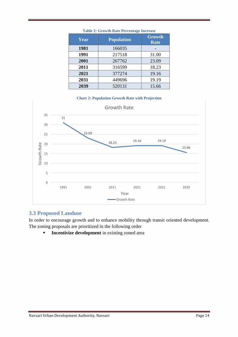
Table 2: Growth Rate Percentage Increase
Year Population Growth
Rate
1981 166035 -
1991 217518 31.00
2001 267762 23.09
2011 316599 18.23
2021 377274 19.16
2031 449696 19.19
2039 520131 15.66
Chart 2: Population Growth Rate with Projection
3.3 Proposed Landuse
In order to encourage growth and to enhance mobility through transit oriented development.
The zoning proposals are prioritized in the following order
▪ Incentivize development in existing zoned area
31
23.09
18.23 19.16 19.19
15.66
0
5
10
15
20
25
30
35
1991 2001 2011 2021 2031 2039
Gro
wth
Rat
e
Year
Growth Rate
Growth Rate
Navsari Urban Development Authority, Navsari Page 15
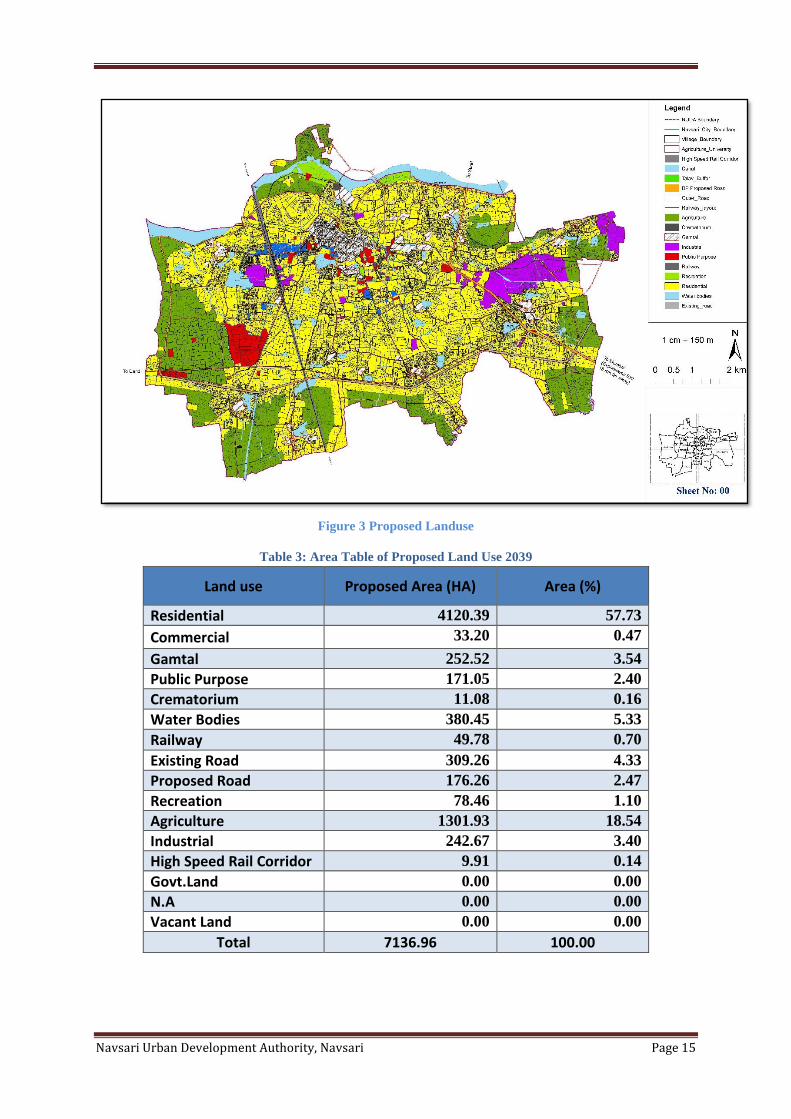
Figure 3 Proposed Landuse
Table 3: Area Table of Proposed Land Use 2039
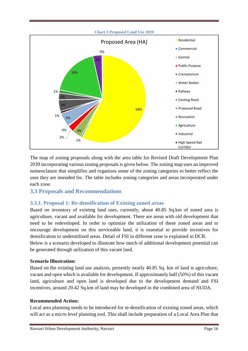
Land use Proposed Area (HA) Area (%)
Residential 4120.39 57.73
Commercial 33.20 0.47
Gamtal 252.52 3.54
Public Purpose 171.05 2.40
Crematorium 11.08 0.16
Water Bodies 380.45 5.33
Railway 49.78 0.70
Existing Road 309.26 4.33
Proposed Road 176.26 2.47
Recreation 78.46 1.10
Agriculture 1301.93 18.54
Industrial 242.67 3.40
High Speed Rail Corridor 9.91 0.14
Govt.Land 0.00 0.00
N.A 0.00 0.00
Vacant Land 0.00 0.00
Total 7136.96 100.00
Navsari Urban Development Authority, Navsari Page 16
Chart 3 Proposed Land Use 2039
The map of zoning proposals along with the area table for Revised Draft Development Plan
2039 incorporating various zoning proposals is given below. The zoning map uses an improved
nomenclature that simplifies and organizes some of the zoning categories to better reflect the
uses they are intended for. The table includes zoning categories and areas incorporated under
each zone.
3.3 Proposals and Recommendations
3.3.1. Proposal 1: Re-densification of Existing zoned areas
Based on inventory of existing land uses, currently, about 40.85 Sq.km of zoned area is
agriculture, vacant and available for development. There are areas with old development that
need to be redeveloped. In order to optimize the utilization of these zoned areas and to
encourage development on this serviceable land, it is essential to provide incentives for
densification to underutilized areas. Detail of FSI in different zone is explained in DCR.
Below is a scenario developed to illustrate how much of additional development potential can
be generated through utilization of this vacant land.
Scenario Illustration:
Based on the existing land use analysis, presently nearly 40.85 Sq. km of land is agriculture,
vacant and open which is available for development. If approximately half (50%) of this vacant
land, agriculture and open land is developed due to the development demand and FSI
incentives, around 20.42 Sq.km of land may be developed in the combined area of NUDA.
Recommended Action:
Local area planning needs to be introduced for re-densification of existing zoned areas, which
will act as a micro level planning tool. This shall include preparation of a Local Area Plan that
58%
1%
4%
2%
0%
5%1%
4%
3%
1%
18%
3%
0%
Proposed Area (HA) Residential
Commercial
Gamtal
Public Purpose
Crematorium
Water Bodies
Railway
Existing Road
Proposed Road
Recreation
Agriculture
Industrial
High Speed RailCorridor
Navsari Urban Development Authority, Navsari Page 17
would provide comprehensive guidance to enhance livability of the area through coordinated
improvements in transport, physical and social infrastructure taking into account the existing
character, land uses and activities taking place in the area. Network road plan shall help
implement the vision of Development Plan at local area level taking into account the needs of
the existing ward/ neighborhood or any area within NUDA.
Step 1: Prepare proposals for preparation of T. P. Schemes for transit corridors:
It is recommended to first prepare proposals for preparation of T. P. Schemes for transit
corridors which will help the improvement of existing conditions and identify improvements
for better accessibility, amenities, infrastructure, land use and urban environment. The T. P.
Schemes should be consistent with the vision and principles of the Development Plan and
should include specific recommendations for implementation.
Step 2: Implementation:
Depending on the type of recommendations various approaches for implementation can be
identified. For example, specific recommendations related to providing certain amenities and
improving infrastructure can be implemented through capital projects. However, if a large scale
improvement and plot reconfiguration is required; revising T.P. Scheme shall be considered.
The revenue generated through T.P. Scheme can be useful resource to recover the cost of
improvements within the area.
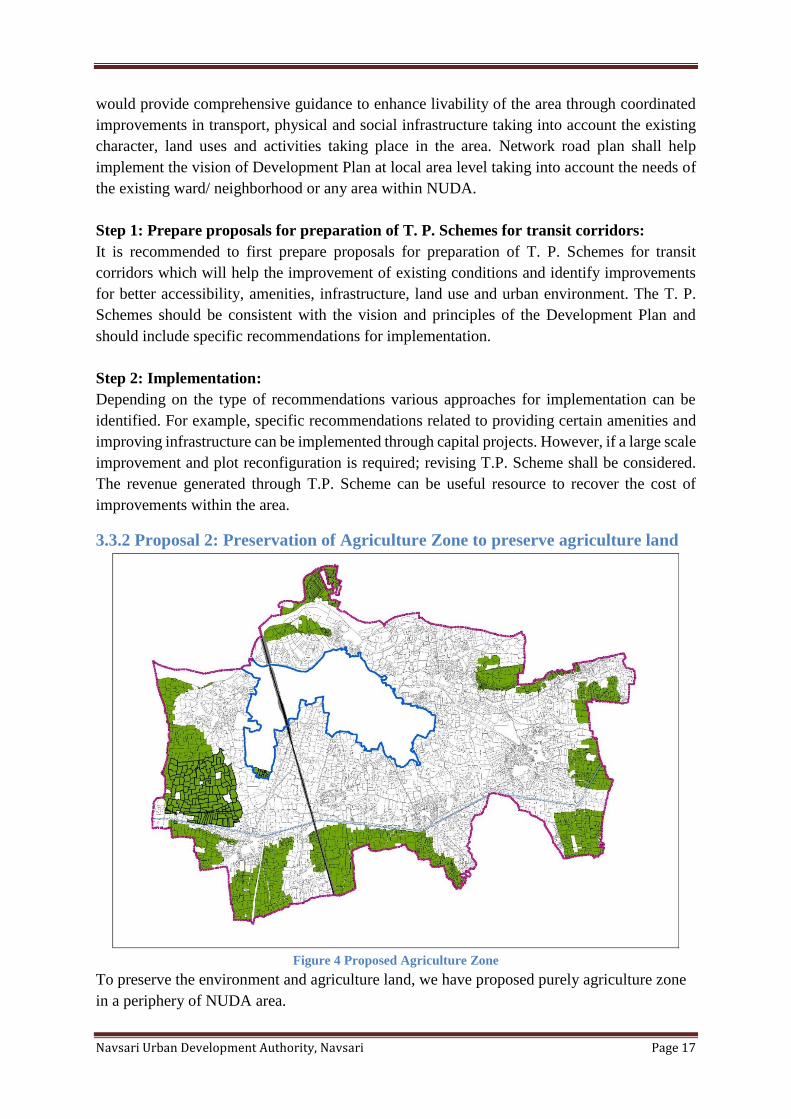
3.3.2 Proposal 2: Preservation of Agriculture Zone to preserve agriculture land
Figure 4 Proposed Agriculture Zone
To preserve the environment and agriculture land, we have proposed purely agriculture zone
in a periphery of NUDA area.
Navsari Urban Development Authority, Navsari Page 18
3.4 Recommended actions for implementation
▪ Prepare Guidelines for Network road plan
▪ Prepare Network road plan for Gamtal, Revenue areas
▪ Prepare Guidelines for TP schemes
Navsari Urban Development Authority, Navsari Page 19
Chapter 4 Transportation and Road Network 4.1 Introduction
A high quality well connected and integrated transportation and Road network is essential to
ensure healthy growth, thriving economy and high livability standard for a city. Today Navsari
has about 3.09 Sq.km of existing road network. As the city continues to grow improvements
and expansions of its transportation network will be required. Such improvements however
must be planned carefully as they influence existing population as well as future growth and
their location choices in the long run. Following the principles of accessibility and mobility,
land use‐transportation coordination and compact growth, this chapter identifies proposals and
recommendations to improve transportation network and mobility in NUDA area.
4.2 Considerations
Similar to other Indian Urban Centers and metropolitan cities, Navsari is also facing severe
problems such as traffic congestion, travel delays, unsafe travel conditions, parking issues,
encroachment etc. Below are some of the important observations as identified in the existing
condition analysis in Part I of this development plan.
▪ Increase in vehicular traffic volumes
▪ Lack of integration between Land use and transportation system
▪ Congestion and bottleneck on major junctions
▪ Inadequate, blocked or unusable sidewalks
▪ Absence of well-defined street classification system
▪ Incomplete street sections with undefined edges and unorganized margin space
▪ Lack of integration between modes of public transport
▪ Absence of pedestrian and bicycle network
▪ Unused and insufficient cycle lanes, not connected with destinations
▪ Inadequate on street and off street parking facilities
▪ Inefficient logistics facilities in and around the city
In order to improve on these transport issues, this Revised Draft Development Plan is elevating
modes of transport and non-motorized transport at higher priority level. Currently Navsari is
relying on GSRTC for public transport.
Towards Kharel express way 18 km away from NUDA area. This express way Mumbai to
Ahmedabad National Road. This way influence on NUDA region is very effective.
Central Government project.
1) High Speed Rail Corridor
The project of high speed train corridor between Ahmedabad and Mumbai. The total length
of proposed High Speed Railway Corridor works out to be 508.17km.
The route of Mumbai Ahmedabad High Speed Rail will be passing through two states,
Maharashtra and Gujarat and one Union Territory, Dadra and Nagar Haveli, of the Union of
India.
Navsari Urban Development Authority, Navsari Page 20
The proposed corridor lies in Western Railway zone. It shall start from Bandra Kurla
Complex in Mumbai and will end near Sabarmati Railway Station in Ahmedabad.
Out of 508.17km, 155.642 km of the proposed alignment falls in Maharastra, 350.530 km in
Gujarat and 2 km in UT of Dadra and Nagar Haveli.
The High Speed Corridor of Mumbai-Ahmedabad has been proposed with 12 Stations
i.e. Mumbai, Thane, Virar, Boisar, Vapi, Bilimora, Surat, Bharuch, Vadodara, Anand/Nadia,
Ahmedabad and Sabarmati, all near major traffic points. Two depots are proposed on either
ends of the corridor one near Thane and one near Sabarmati Rail Depot
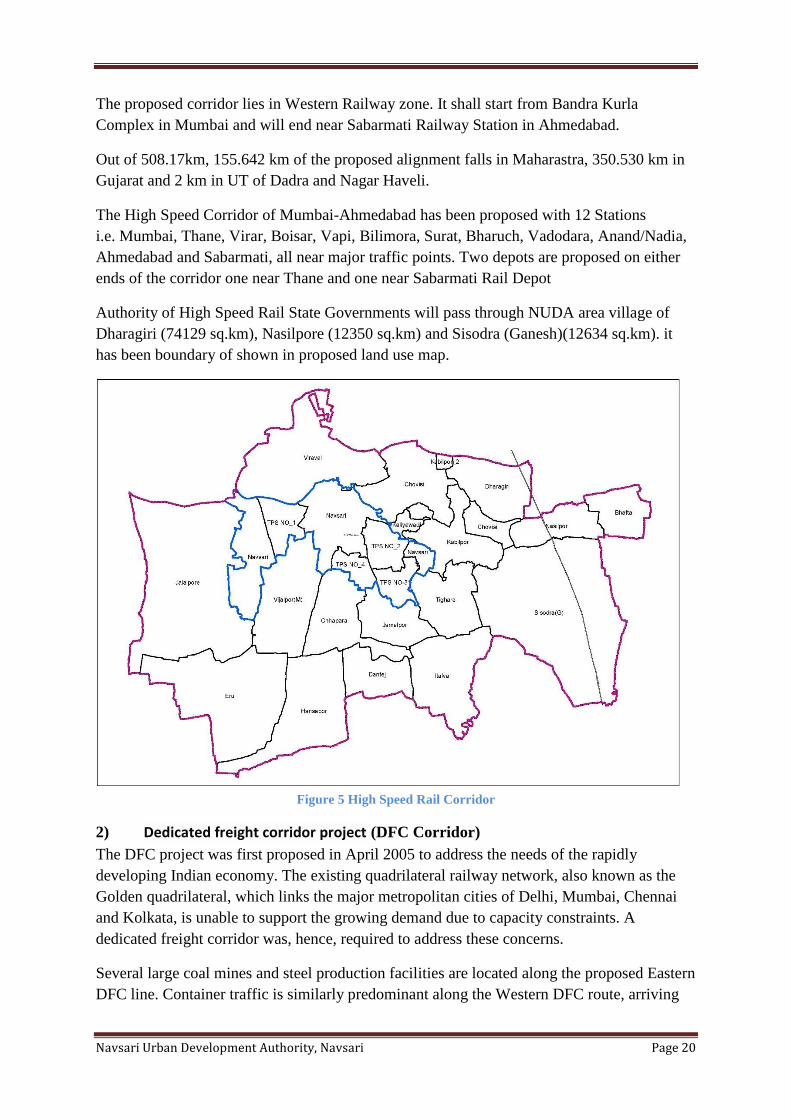
Authority of High Speed Rail State Governments will pass through NUDA area village of
Dharagiri (74129 sq.km), Nasilpore (12350 sq.km) and Sisodra (Ganesh)(12634 sq.km). it
has been boundary of shown in proposed land use map.
Figure 5 High Speed Rail Corridor
2) Dedicated freight corridor project (DFC Corridor)
The DFC project was first proposed in April 2005 to address the needs of the rapidly
developing Indian economy. The existing quadrilateral railway network, also known as the
Golden quadrilateral, which links the major metropolitan cities of Delhi, Mumbai, Chennai
and Kolkata, is unable to support the growing demand due to capacity constraints. A
dedicated freight corridor was, hence, required to address these concerns.
Several large coal mines and steel production facilities are located along the proposed Eastern
DFC line. Container traffic is similarly predominant along the Western DFC route, arriving
Navsari Urban Development Authority, Navsari Page 21
mainly from the Jawaharlal Nehru Port (JNPT). By 2022, the port is expected to handle 5.29
million 20ft-equivalent units of container traffic.
Proposals and Recommendations
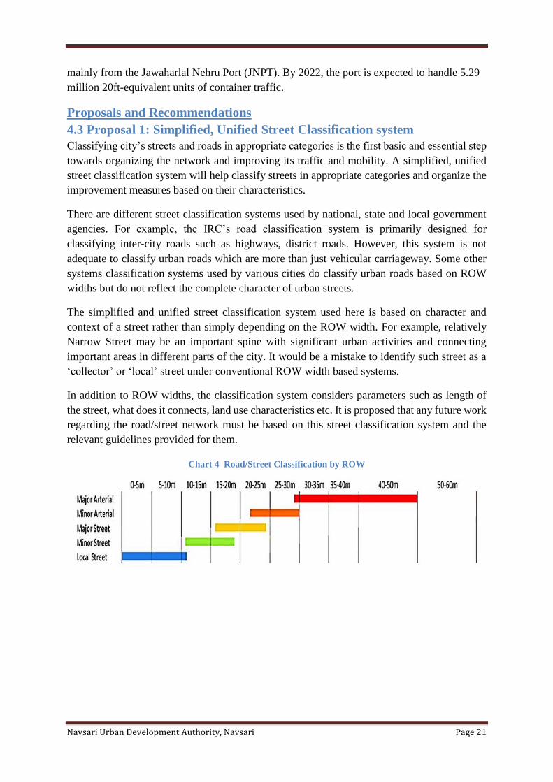
4.3 Proposal 1: Simplified, Unified Street Classification system
Classifying city’s streets and roads in appropriate categories is the first basic and essential step
towards organizing the network and improving its traffic and mobility. A simplified, unified
street classification system will help classify streets in appropriate categories and organize the
improvement measures based on their characteristics.
There are different street classification systems used by national, state and local government
agencies. For example, the IRC’s road classification system is primarily designed for
classifying inter‐city roads such as highways, district roads. However, this system is not
adequate to classify urban roads which are more than just vehicular carriageway. Some other
systems classification systems used by various cities do classify urban roads based on ROW
widths but do not reflect the complete character of urban streets.
The simplified and unified street classification system used here is based on character and
context of a street rather than simply depending on the ROW width. For example, relatively
Narrow Street may be an important spine with significant urban activities and connecting
important areas in different parts of the city. It would be a mistake to identify such street as a
‘collector’ or ‘local’ street under conventional ROW width based systems.
In addition to ROW widths, the classification system considers parameters such as length of
the street, what does it connects, land use characteristics etc. It is proposed that any future work
regarding the road/street network must be based on this street classification system and the
relevant guidelines provided for them.
Chart 4 Road/Street Classification by ROW
Navsari Urban Development Authority, Navsari Page 22
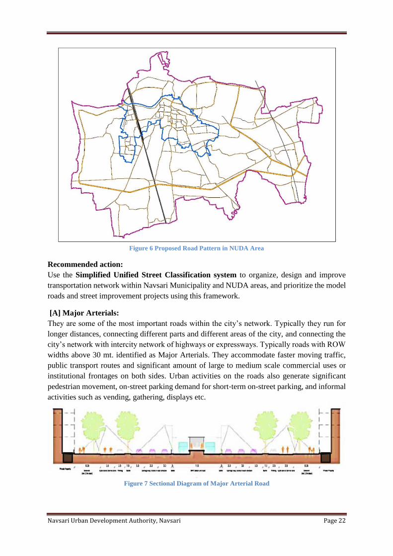
Figure 6 Proposed Road Pattern in NUDA Area
Recommended action:
Use the Simplified Unified Street Classification system to organize, design and improve
transportation network within Navsari Municipality and NUDA areas, and prioritize the model
roads and street improvement projects using this framework.
[A] Major Arterials:
They are some of the most important roads within the city’s network. Typically they run for
longer distances, connecting different parts and different areas of the city, and connecting the
city’s network with intercity network of highways or expressways. Typically roads with ROW
widths above 30 mt. identified as Major Arterials. They accommodate faster moving traffic,
public transport routes and significant amount of large to medium scale commercial uses or
institutional frontages on both sides. Urban activities on the roads also generate significant
pedestrian movement, on‐street parking demand for short‐term on-street parking, and informal
activities such as vending, gathering, displays etc.
Figure 7 Sectional Diagram of Major Arterial Road
Navsari Urban Development Authority, Navsari Page 23
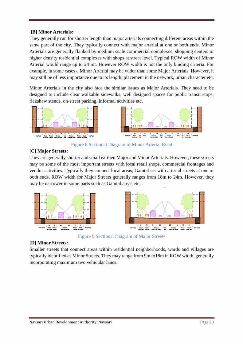
[B] Minor Arterials:
They generally run for shorter length than major arterials connecting different areas within the
same part of the city. They typically connect with major arterial at one or both ends. Minor
Arterials are generally flanked by medium scale commercial complexes, shopping centers or
higher density residential complexes with shops at street level. Typical ROW width of Minor
Arterial would range up to 24 mt. However ROW width is not the only binding criteria. For
example, in some cases a Minor Arterial may be wider than some Major Arterials. However, it
may still be of less importance due to its length, placement in the network, urban character etc.
Minor Arterials in the city also face the similar issues as Major Arterials. They need to be
designed to include clear walkable sidewalks, well designed spaces for public transit stops,
rickshaw stands, on‐street parking, informal activities etc.
Figure 8 Sectional Diagram of Minor Arterial Road
[C] Major Streets:
They are generally shorter and small earthen Major and Minor Arterials. However, these streets
may be some of the most important streets with local retail shops, commercial frontages and
vendor activities. Typically they connect local areas, Gamtal set with arterial streets at one or
both ends. ROW width for Major Streets generally ranges from 18m to 24m. However, they
may be narrower in some parts such as Gamtal areas etc.
Figure 9 Sectional Diagram of Major Streets
[D] Minor Streets:
Smaller streets that connect areas within residential neighborhoods, wards and villages are
typically identified as Minor Streets. They may range from 9m to18m in ROW width, generally
incorporating maximum two vehicular lanes.
Navsari Urban Development Authority, Navsari Page 24
Figure 10 Sectional Diagram of Minor Streets
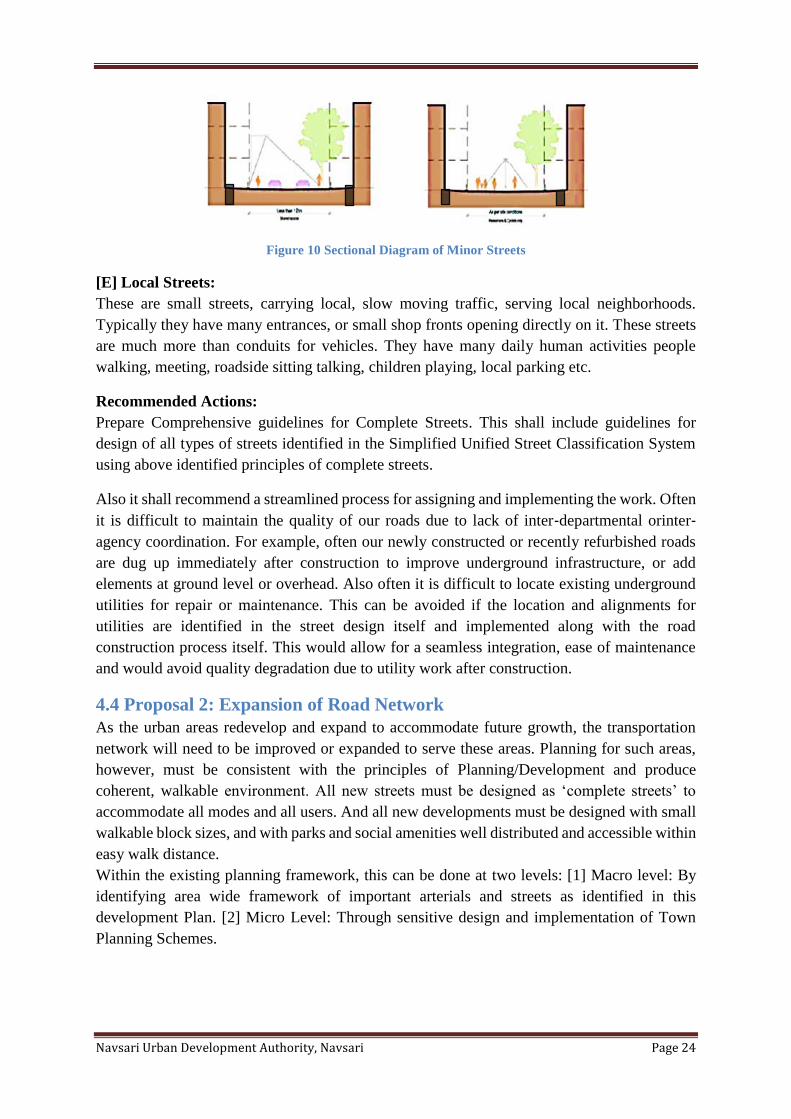
[E] Local Streets:
These are small streets, carrying local, slow moving traffic, serving local neighborhoods.
Typically they have many entrances, or small shop fronts opening directly on it. These streets
are much more than conduits for vehicles. They have many daily human activities people
walking, meeting, roadside sitting talking, children playing, local parking etc.
Recommended Actions:
Prepare Comprehensive guidelines for Complete Streets. This shall include guidelines for
design of all types of streets identified in the Simplified Unified Street Classification System
using above identified principles of complete streets.
Also it shall recommend a streamlined process for assigning and implementing the work. Often
it is difficult to maintain the quality of our roads due to lack of inter‐departmental orinter‐
agency coordination. For example, often our newly constructed or recently refurbished roads
are dug up immediately after construction to improve underground infrastructure, or add
elements at ground level or overhead. Also often it is difficult to locate existing underground
utilities for repair or maintenance. This can be avoided if the location and alignments for
utilities are identified in the street design itself and implemented along with the road
construction process itself. This would allow for a seamless integration, ease of maintenance
and would avoid quality degradation due to utility work after construction.
4.4 Proposal 2: Expansion of Road Network
As the urban areas redevelop and expand to accommodate future growth, the transportation
network will need to be improved or expanded to serve these areas. Planning for such areas,
however, must be consistent with the principles of Planning/Development and produce
coherent, walkable environment. All new streets must be designed as ‘complete streets’ to
accommodate all modes and all users. And all new developments must be designed with small
walkable block sizes, and with parks and social amenities well distributed and accessible within
easy walk distance.
Within the existing planning framework, this can be done at two levels: [1] Macro level: By
identifying area wide framework of important arterials and streets as identified in this
development Plan. [2] Micro Level: Through sensitive design and implementation of Town
Planning Schemes.
Navsari Urban Development Authority, Navsari Page 25
[1] Macro level framework:
Map below identifies the macro level framework of important arterials and streets that shall be
designed and implemented as ‘Complete Streets’. The network follows Ring and Radial pattern
which allows for the expansion of urban area in a contiguous and compact manner. It also
provides easy connections in both directions, with radials connecting with city’s central areas
and rings connecting with the surrounding suburban areas. Some of these radials extend to
connect with the Growth Centers.
Achieving compact city form however, does not only depend on the right framework of
transportation, but it must be supported by appropriate zoning framework that helps concentrate
densities closer to the existing urban areas and along desirable corridors.
Generally growth follows infrastructure. Anticipation and land speculations along proposed
network may artificially trigger developments in far‐flung areas without sufficient
infrastructure, resulting into high traffic volumes on insufficient rural network, increased
congestion, longer travel times and reduced quality of personal and social life. Therefore it is
important to build the infrastructure at right time in phased manner and also to expand the
zoned area in phased manner at appropriate time.
[2] Micro level network:
The micro level planning for the new development areas is to be carried out during preparation
of Town Planning Schemes. For new developments to be sustainable, livable and walkable all
new Town Planning Scheme layouts must be designed well to have integrated network of
complete streets. It must keep the block sizes small and parks, gardens and social amenities
must be well distributed and located within easy walk distance from the residents. This will
require a deeper understanding of sustainable site planning, land use transportation
coordination and urban design while preparing Town Planning Schemes.
Recommended Actions:
Prepare Comprehensive guidelines for preparing Town Planning Schemes. This would help
bring consistency and coherence in preparation of TP Scheme layouts and make them more
sustainable, livable and walkable. It would include guidelines for preparing layout to work with
the existing natural topography and drainage systems, guidelines for laying out streets and
blocks to make the development more walk able and for improved connectivity with public
amenities. It would also include guidelines for implementation sequence in order to develop
high quality streets, infrastructure and urban environment.
4.5 Proposal 3: Network Improvement
In urban context, a network with multiple smaller streets providing alternative routes and
distributing traffic is more efficient and desirable than a network with a few larger roads
funneling large volumes of traffic. The latter has higher chances of creating bottlenecks and
chokepoints in the network. Releasing congestion pressure on network requires strategic
insertion of new connection and strategic improvements on selected locations, including
widening of selected alternative routes, strategic improvements of certain intersections,
installing Intelligent Transportation Systems (ITS) etc.
Navsari Urban Development Authority, Navsari Page 26
It is important to carry out a detailed study of existing travel patterns by various modes
on the network, and travel demand analysis to understand where to make such
improvements. Some of the major improvements proposed to improve the network throughout
the city and increase its capacity are as below.
[A] Connecting missing links:
In order to release congestion pressure from the network, to improve connectivity and to
enhance walkability a set of new or improved linkages and/or improved intersection design are
required, below is the map showing some of the links and intersections for potential
improvements. A more detailed assessment and study is recommended to verify them and
identify more such links and intersections for improvements.
[B] Bridges and Underpasses:
Features such as bridges and underpasses are important to ensure connectivity of major arterials
and to reduce congestion in the network.
Table 4 Number of Proposed Bridges in Navsari Municipality and NUDA
No. Type NUDA
1 Bridge over River 5
Flyovers and underpasses are important to reduce congestion. They may end up dividing the
neighborhoods and impacting commercial viability of existing business on the street sides.
Therefore, it is crucial to design the flyovers in a way that allows cross connectivity for
pedestrians at street level and causing minimum impact on the adjoining properties.
[C] Proposed 18 mt Road:
Road is dividing factor in landuse plan. There is 18 mt proposed DP road both side Along
canal. This road pattern is Ring road for NUDA area.
4.6 Proposal 4: Pedestrian Network
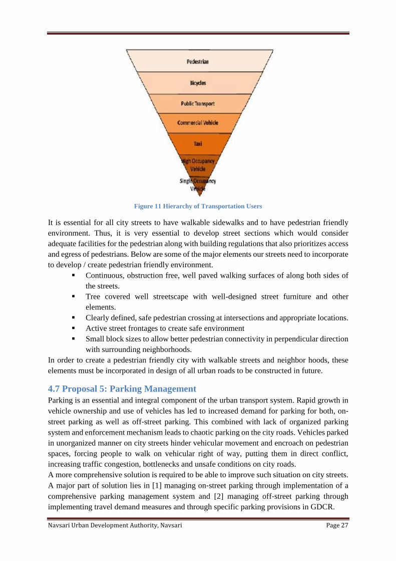
Every trip first begins on feet and ends on feet. Walking is the first and the worst natural mode
of transport for us as human beings. Everyone is a pedestrian for part of their trip even if they
are driving or using public transport. Walking is also the most energy efficient, healthy and
sustainable mode of transport. Therefore, allowing and encouraging walking must be the first
priority while planning our cities transport infrastructure and building our streets.
Navsari Urban Development Authority, Navsari Page 27
Figure 11 Hierarchy of Transportation Users
It is essential for all city streets to have walkable sidewalks and to have pedestrian friendly
environment. Thus, it is very essential to develop street sections which would consider
adequate facilities for the pedestrian along with building regulations that also prioritizes access
and egress of pedestrians. Below are some of the major elements our streets need to incorporate
to develop / create pedestrian friendly environment.
▪ Continuous, obstruction free, well paved walking surfaces of along both sides of
the streets.
▪ Tree covered well streetscape with well-designed street furniture and other
elements.
▪ Clearly defined, safe pedestrian crossing at intersections and appropriate locations.
▪ Active street frontages to create safe environment
▪ Small block sizes to allow better pedestrian connectivity in perpendicular direction
with surrounding neighborhoods.
In order to create a pedestrian friendly city with walkable streets and neighbor hoods, these
elements must be incorporated in design of all urban roads to be constructed in future.
4.7 Proposal 5: Parking Management
Parking is an essential and integral component of the urban transport system. Rapid growth in
vehicle ownership and use of vehicles has led to increased demand for parking for both, on‐
street parking as well as off‐street parking. This combined with lack of organized parking
system and enforcement mechanism leads to chaotic parking on the city roads. Vehicles parked
in unorganized manner on city streets hinder vehicular movement and encroach on pedestrian
spaces, forcing people to walk on vehicular right of way, putting them in direct conflict,
increasing traffic congestion, bottlenecks and unsafe conditions on city roads.
A more comprehensive solution is required to be able to improve such situation on city streets.
A major part of solution lies in [1] managing on‐street parking through implementation of a
comprehensive parking management system and [2] managing off‐street parking through
implementing travel demand measures and through specific parking provisions in GDCR.
Navsari Urban Development Authority, Navsari Page 28
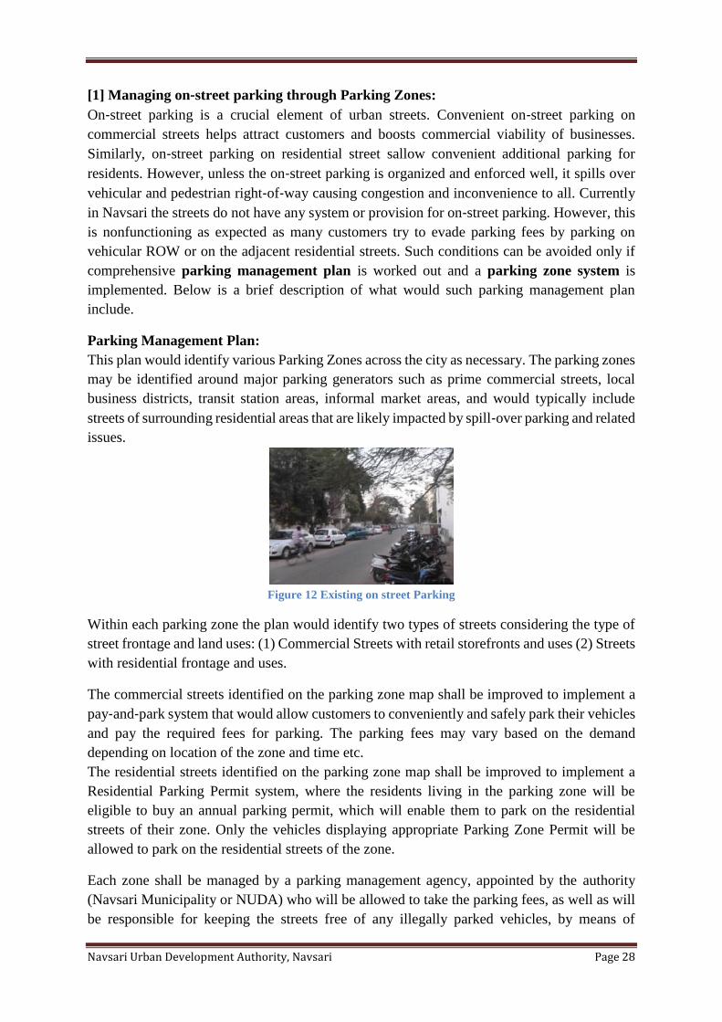
[1] Managing on‐street parking through Parking Zones:
On‐street parking is a crucial element of urban streets. Convenient on‐street parking on
commercial streets helps attract customers and boosts commercial viability of businesses.
Similarly, on‐street parking on residential street sallow convenient additional parking for
residents. However, unless the on‐street parking is organized and enforced well, it spills over
vehicular and pedestrian right‐of‐way causing congestion and inconvenience to all. Currently
in Navsari the streets do not have any system or provision for on‐street parking. However, this
is nonfunctioning as expected as many customers try to evade parking fees by parking on
vehicular ROW or on the adjacent residential streets. Such conditions can be avoided only if
comprehensive parking management plan is worked out and a parking zone system is
implemented. Below is a brief description of what would such parking management plan
include.
Parking Management Plan:
This plan would identify various Parking Zones across the city as necessary. The parking zones
may be identified around major parking generators such as prime commercial streets, local
business districts, transit station areas, informal market areas, and would typically include
streets of surrounding residential areas that are likely impacted by spill‐over parking and related
issues.
Figure 12 Existing on street Parking
Within each parking zone the plan would identify two types of streets considering the type of
street frontage and land uses: (1) Commercial Streets with retail storefronts and uses (2) Streets
with residential frontage and uses.
The commercial streets identified on the parking zone map shall be improved to implement a
pay‐and‐park system that would allow customers to conveniently and safely park their vehicles
and pay the required fees for parking. The parking fees may vary based on the demand
depending on location of the zone and time etc.
The residential streets identified on the parking zone map shall be improved to implement a
Residential Parking Permit system, where the residents living in the parking zone will be
eligible to buy an annual parking permit, which will enable them to park on the residential
streets of their zone. Only the vehicles displaying appropriate Parking Zone Permit will be
allowed to park on the residential streets of the zone.
Each zone shall be managed by a parking management agency, appointed by the authority
(Navsari Municipality or NUDA) who will be allowed to take the parking fees, as well as will
be responsible for keeping the streets free of any illegally parked vehicles, by means of
Navsari Urban Development Authority, Navsari Page 29
charging fine or towing as necessary. The primary objective of Parking Management Plan is to
develop and implement a self‐sustaining mechanism:
▪ To organize on‐street parking
▪ To enable enforcement
▪ To manage spill‐over effect on adjacent streets
▪ To generate revenue to pay for the cost of implementing the system
In addition to identifying various parking zones, Parking Management Plan may also include
detailed design for a pilot project, guidelines and standards for parking spaces, signage, parking
lanes etc.
[2] Managing Off-Street Parking:
Off street parking can be classified in 2 categories.
▪ Off-street public parking and
▪ Off‐street private parking.
Off street public parking includes public parking plots and multilevel parking structures. These
must be strategically located
▪ Near public transit stations to incentivize commuters to park their vehicles and use
public transit.
▪ At significant destinations with high demand
Public parking must be on chargeable basis and the parking fees must be carefully determined.
Also, Parking Management Plan should identify appropriate location and recommend
guidelines for identification of such locations and parking fee structures.
Off street private parking includes parking provided on individually owned plots with
commercial, residential, etc. uses. Parking requirements for these plots are identified in GDCR.
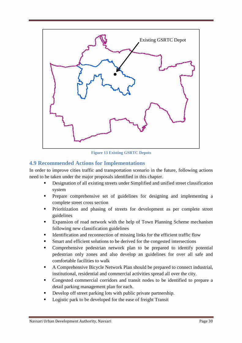
4.8 Proposal 6: Decentralization of GSRTC Depots
The GSRTC buses provide a major connectivity between Navsari and other destinations of the
state. In existing scenario, all GSRTC traffic is forced to connect with the central depot. As a
result it attracts commuters within the city and again travels through the city center to reach its
destination. This centralized location causes traffic congestion, parking issues and number of
problems within the city.
Therefore, it is suggested to decentralize the existing Central Depot and peripheral new
locations have been identified, which are served by major road and public transport
connectivity.
Navsari Urban Development Authority, Navsari Page 30
Figure 13 Existing GSRTC Depots
4.9 Recommended Actions for Implementations
In order to improve cities traffic and transportation scenario in the future, following actions
need to be taken under the major proposals identified in this chapter.
▪ Designation of all existing streets under Simplified and unified street classification
system
▪ Prepare comprehensive set of guidelines for designing and implementing a
complete street cross section
▪ Prioritization and phasing of streets for development as per complete street
guidelines
▪ Expansion of road network with the help of Town Planning Scheme mechanism
following new classification guidelines
▪ Identification and reconnection of missing links for the efficient traffic flow
▪ Smart and efficient solutions to be derived for the congested intersections
▪ Comprehensive pedestrian network plan to be prepared to identify potential
pedestrian only zones and also develop an guidelines for over all safe and
comfortable facilities to walk
▪ A Comprehensive Bicycle Network Plan should be prepared to connect industrial,
institutional, residential and commercial activities spread all over the city.
▪ Congested commercial corridors and transit nodes to be identified to prepare a
detail parking management plan for each.
▪ Develop off street parking lots with public private partnership.
▪ Logistic park to be developed for the ease of freight Transit
Existing GSRTC Depot
Navsari Urban Development Authority, Navsari Page 31
▪ Designation of transit nodes for the provision of required respective facilities
around
▪ A comprehensive city level signage and way finding plan should be prepared and
implemented
▪ Comprehensive Freight Management Plan to be prepared
Navsari Urban Development Authority, Navsari Page 32
Chapter 5 Green Network 5.1 Introduction
Green network includes parks, green streets, waterfronts and urban groves. Green open spaces
such as parks and gardens play indispensable role in maintaining the physical environment and
social character of the neighborhoods in the city. They serve as community forums for social
interactions, for children to play, for people to entertain and exercise, etc. Green cover along
the city streets also make the streets more walkable and make the city environment more
pleasant and helps reduce heat island effect.
With increase in population, the need for a variety of parks and open spaces is constantly
increasing. The proposals in this section are focused on developing a vibrant livable city that
has variety of parks, gardens, public open spaces and green streets for its residents providing a
healthy and high-quality environment.
5.2 Considerations
Currently, we have about 0.32 sq.km of the area identified as parks and gardens in NUDA.
Therefore, there is a need to increase amount of parks and gardens to align with URDPFI
guidelines to sufficiently serve the existing population. Below are a set of major considerations
for the subsequent proposals included in this chapter.
▪ Transform the city character by increasing the green cover across various parts in
the city.
▪ Develop parks and gardens to serve at neighborhood level and city level and
regional level.
▪ Distribute parks and gardens within ten minutes of walking distance to all the
residents which would be taken care while implementing the development plan
proposal at micro level using Town Planning Scheme mechanism.
▪ Create a well-connected network of contiguous green spaces which includes parks,
gardens, plazas, groves, green streets and green boulevards.
▪ Develop green streets as attractive streetscapes to serves community connections
linking schools, parks, open spaces, offices through improved pedestrian and
bicycle connectivity.
Understanding the considerations and the existing level of parks and open spaces in NUDA, a
set of proposals and recommendations have been planned to provide adequate recreational
spaces catering the needs of the neighborhoods in the city.
Proposals and Recommendations
For the newly developing areas the allocation of land parcels for parks and open spaces are
majorly implemented through the Town Planning Scheme Mechanism.
Recommended Action:
New parks and gardens can be developed within the developed area through Network road
plan. These plans will assess existing conditions and identify improvements related to
community spaces, development or up gradation of parks and open spaces etc. In case of large
scale improvements, TP scheme may be modified.
Navsari Urban Development Authority, Navsari Page 33
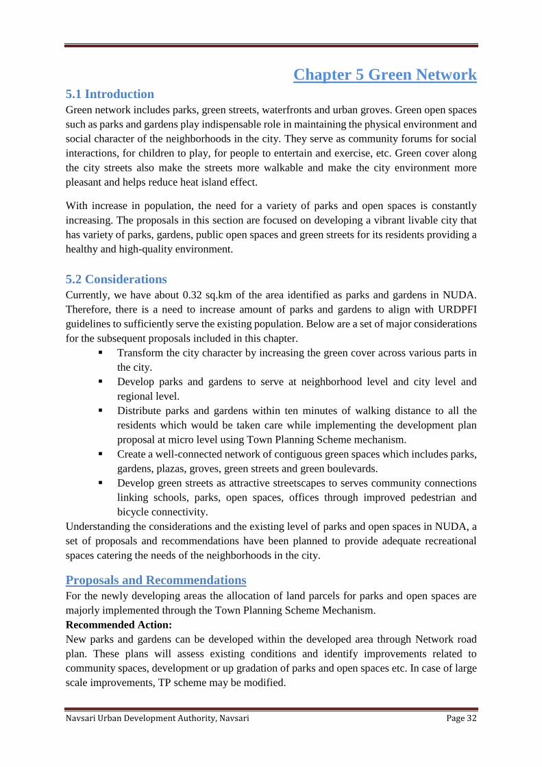
5.3 Proposal 1: Green Street Network
Green shaded streets create attractive streetscapes that increase walkability, increase green
cover, reduce direct heating of paved surfaces and reduce heat island effect. The purpose of
Green Street is to
▪ Enhance pedestrian circulation and create open space opportunities in medium to
high density residential areas lacking adequate public open space.
▪ Create a vibrant pedestrian environment in the street right-of-way that attracts
pedestrians.
▪ Support economic activity by creating an attractive and welcoming "front door" for
pedestrians.
▪ Strengthen connections between residential enclaves and other amenities by
improving the streetscape for pedestrians, bicycles and transit patrons.
Figure 14 Examples of Green shaded Pedestrian Street and landscaped street
Considering the hot and dry climatic context, mixed use development, shorter average trip
lengths and high pedestrian volume it is very essential to develop green streets in the city which
would encourage people to walk and cycle but in organized way on street ROW. Thus
identification of existing green streets and extending them up to important public open spaces
and amenities, educational institutes, transportation and recreational nodes in the city should
be done to form a complete green network; facilitating safe and pleasant path for the pedestrians
to commute.
While designing the Green Streets following design principles should be considered:
▪ Emphasize pedestrians and open space over other street functions.
▪ Design should complement and enhance adjacent land uses.
▪ Keep traffic speed and volume low.
▪ Response to site specific conditions.
Recommended Action:
Detail design of all the identified Green Streets would be the part of the ‘Green Streets Plan
‘that would identify types of green streets and include the details of necessary amenities, street
section, contextual requirements, type of trees and landscape and correlation with traffic flow
on the street.
Navsari Urban Development Authority, Navsari Page 34
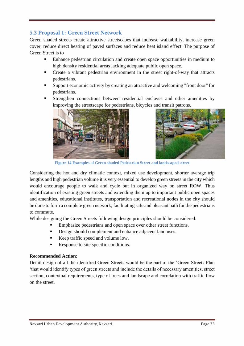
Figure 15 Envisioning Green Street Development
5.4 Proposal 2: Waterfront Development
NUDA area contains water body as a river and lakes. Development of waterfront not only
preserves the water body but also helps in creation of additional recreational and green space.
Waterfront development projects will make the waterfronts accessible to the public with new
parks, gardens, plazas and numerous public facilities like cultural centers, museums, sports
facilities, open air markets, etc. While developing the waterfronts it is crucial to consider the
location and environmental context within which the water body is located. Based on their
urban context, the waterfront development can be categorized in three categories.
i) Water bodies in urban context
ii) Water bodies in rural context
iii) Water bodies in natural context
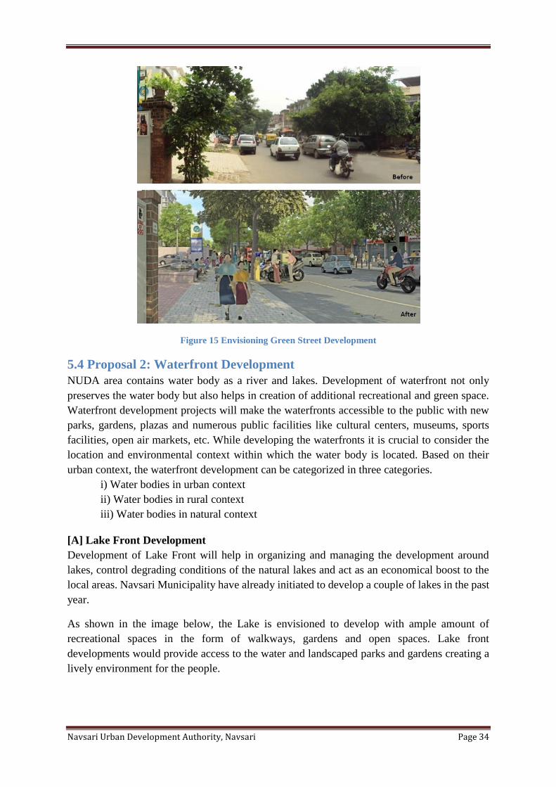
[A] Lake Front Development
Development of Lake Front will help in organizing and managing the development around
lakes, control degrading conditions of the natural lakes and act as an economical boost to the
local areas. Navsari Municipality have already initiated to develop a couple of lakes in the past
year.
As shown in the image below, the Lake is envisioned to develop with ample amount of
recreational spaces in the form of walkways, gardens and open spaces. Lake front
developments would provide access to the water and landscaped parks and gardens creating a
lively environment for the people.
Navsari Urban Development Authority, Navsari Page 35
Recommended Action:
‘Comprehensive Lake Development
Plan’ needs to be prepared that classifies
the lakes based on their contexts and
identifies guidelines for their
development considering their natural
environment and urban setting.
[B] Riverfront Development
The Riverfront Development Project is
an environmental improvement, social
uplift and urban rejuvenation project
that will renew the city. The project will
make the riverfront accessible to the
public by reclaiming proper land from
the river bed.
Many new parks, gardens and plazas
proposed on the reclaimed land will
provide the much needed green space to
the city. The project will add new 88.44 ha land for parks, gardens as a recreation zone to the
city. Proposed new parallel streets to the river will augment the city’s road network and provide
better access to the riverfront. Pedestrian sspromenade along the complete length of the
Riverfront forms a major public open space which allows people to reach close to water and
permits water recreational activities. The new Development Plan has identified the area around
Riverfront as a special area development zone to carry out focused development.
5.5 Proposal 5: Recreational area around Water body
NUDA area contains water body as a river and water Bodies. Development of water bodies are
not only preserves, but also helps in creation of additional recreational and green space. Total
45 water bodies in NUDA. Development of as a recreational area around three water bodies:
Italava, Dantej and Hansapore village. There are three water bodies around 15mt buffer as
recreational area along with river bank.
Figure 16 Illustration: Envisioning Lake Development
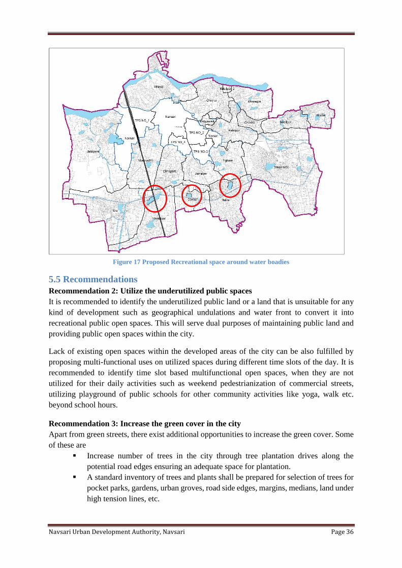
Navsari Urban Development Authority, Navsari Page 36
Figure 17 Proposed Recreational space around water boadies
5.5 Recommendations
Recommendation 2: Utilize the underutilized public spaces
It is recommended to identify the underutilized public land or a land that is unsuitable for any
kind of development such as geographical undulations and water front to convert it into
recreational public open spaces. This will serve dual purposes of maintaining public land and
providing public open spaces within the city.
Lack of existing open spaces within the developed areas of the city can be also fulfilled by
proposing multi-functional uses on utilized spaces during different time slots of the day. It is
recommended to identify time slot based multifunctional open spaces, when they are not
utilized for their daily activities such as weekend pedestrianization of commercial streets,
utilizing playground of public schools for other community activities like yoga, walk etc.
beyond school hours.
Recommendation 3: Increase the green cover in the city
Apart from green streets, there exist additional opportunities to increase the green cover. Some
of these are
▪ Increase number of trees in the city through tree plantation drives along the
potential road edges ensuring an adequate space for plantation.
▪ A standard inventory of trees and plants shall be prepared for selection of trees for
pocket parks, gardens, urban groves, road side edges, margins, medians, land under
high tension lines, etc.
Navsari Urban Development Authority, Navsari Page 37
5.6 Recommended actions for implementation
In order to implement the proposals and recommendations to further enhance green network in
Navsari, following actions need to be taken to improve green open space scenario as identified
under major proposals in this chapter.
▪ Categorization of all existing parks and open spaces as a pocket park, neighborhood
park, community park, city level park and regional park.
▪ Inventory of all existing public land for identification of vacant or underutilized
parcels.
▪ Converting those vacant or underutilized public land parcels in to green parks and
gardens
▪ Preparation of ‘Green Network Plan’ for detail design and implementation of green
streets
▪ Prioritization of potential lakes, Rivers and water bodies stretches for water front
development
▪ Prepare a Comprehensive Lake development Plan for NUDA area
▪ Prepare Lakefront Development Plans for individual lakes
▪ Identification of existing and proposed sites for urban groves
▪ Develop a mechanism for frequent monitoring and periodic maintenance of parks
and open spaces
▪ Standard inventory need to be established for selection of trees at various locations
and functions
▪ Ensure public transport access to all city level and regional parks
Navsari Urban Development Authority, Navsari Page 38
Chapter 6 Physical Infrastructure Provision of high‐quality physical infrastructure facilities is necessary to make any city more
habitable. Various measures had been taken in the previous development plan for improving
the physical infrastructure facilities in Navsari. However, due to the rapid growth of population
within the city and the expansion of developed areas there is a need for constant up gradation
and expansion of the physical infrastructure.
Therefore, the current Development Plan introduces several plans, proposals and
recommendations taking into consideration the future population growth for improvement in
physical infrastructure facilities which include water supply, sewerage system, storm water
management and solid waste management.
6.1 Water Supply
6.1.1 Basic Considerations –water supply
Below are some major considerations that are useful for various proposals for water supply in
NUDA area. Currently, nearly 30 MLD of Navsari Municipality area is served by water supply
network. It means presently Navsari Municipality supply 165 liter per capita which is more
than actual requirement. For the current population at least 50 MLD water is required.
However, due to increasing population there is constant pressure to upgrade and install the
water supply network lines.
Following Table shows the water demand for projected population of NUDA area.
Table 5 Demand analysis of Water Supply
Sr. No. Year Total
Population
Water Demand
in (MLD)
1 2021 377274 50
3 2031 449696 60
4 2039 520131 70
▪ Ensuring water is accessible to all the citizens on a continuous basis
▪ Increase the treatment capacity of the water treatment plants in order to fulfill the
need of the population for the coming 20 years.
▪ Considered surface water as the primary source for water supply so as to prevent
the usage of ground water resources by the residents.
As shown in table, currently there is a demand gap of around 30 MLD in Navsari Municipality
areas with the consideration of NUDA population-2011, there is 50 MLD water is required.
With the increase in population the projected water demand is 60 MLD and 70 MLD for the
year 20231-39 respectively for total NUDA population.
6.1.2 Proposals & Recommendations:
Keeping the principle of provision of efficient and adequate physical infrastructure, proposals
and recommendations have been formulated. Through this development plan, inefficient water
supply system is proposed to serve Navsari area adequately.
Navsari Urban Development Authority, Navsari Page 39
Proposal 1: Up gradation of water treatment plants (WTPs)
Navsari city has its present water demand is 30 MLD. Water is supplied through 25,000 tap
connections by three major surface water sources namely kakrapar branch canal, Dudhiya
Talav and 28 nos. of bore wells. Navsari city has more than 4 nos. of Hand pumps and 136 nos.
of stand posts as Ground Water Sources situated all over city area. Existing storage capacity of
water supply system is 850ML.
Up gradation of water is required according to NUDA population and it is require to increase
the total treatment capacity as per the demand under this development plan, so as to facilitate
the presents well as future population of Navsari Municipality as well as NUDA area with
adequate water supply.
Proposal 2: Up gradation and development of new water supply network
Currently approximately 70% Population within Navsari Municipality limit is served by the
water supply network. Remaining 30% people within Navsari Municipality are dependent on
tanker, bore or hand pump. To serve the remaining un-served area it is proposed to expand the
water supply network in the remaining area within Navsari Municipality area. To facilitate
existing population within urbanized area of Navsari and to cater the needs of the future
population, nearly, additional water supply network lines are proposed to be implemented in
urbanized area of Navsari area. Similarly new water supply network lines are proposed to be
implemented in the growth centers considering current as well as future population.
In addition, refurbishment of old water supply network shall be carried out for the entire NUDA
area by 2001.
Other Recommendations:
Other than the above mentioned proposals regarding adequate water supply and complete water
supply network, some of the recommendations that can be taken up as projects in the coming
years
▪ Replace the existing decaying consumer connections to avoid problems of leakage,
low pressure and contamination.
▪ Currently, water is being provided only for a few hours in a day. The water supply
system may be enhanced to provide 24 hour supply of water and should be
regulated by water meters.
▪ Develop a GIS based management information system to collect and maintain
detailed information on every pipeline section and pumping machinery with
attribution age, material, etc.
6.2 Sewerage
Currently nearly 60% of population within Navsari Municipality is covered under sewerage
network. The remaining shall be catered through expansion of sewerage network through this
Development Plan.
6.2.1 Basic considerations– Sewerage
Following considerations have been taken into account while formulating the proposals and
recommendations related to sewerage infrastructure.
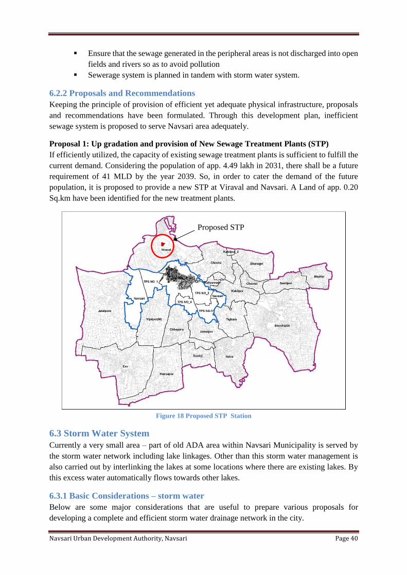
Navsari Urban Development Authority, Navsari Page 40
▪ Ensure that the sewage generated in the peripheral areas is not discharged into open
fields and rivers so as to avoid pollution
▪ Sewerage system is planned in tandem with storm water system.
6.2.2 Proposals and Recommendations
Keeping the principle of provision of efficient yet adequate physical infrastructure, proposals
and recommendations have been formulated. Through this development plan, inefficient
sewage system is proposed to serve Navsari area adequately.
Proposal 1: Up gradation and provision of New Sewage Treatment Plants (STP)
If efficiently utilized, the capacity of existing sewage treatment plants is sufficient to fulfill the
current demand. Considering the population of app. 4.49 lakh in 2031, there shall be a future
requirement of 41 MLD by the year 2039. So, in order to cater the demand of the future
population, it is proposed to provide a new STP at Viraval and Navsari. A Land of app. 0.20
Sq.km have been identified for the new treatment plants.
Figure 18 Proposed STP Station
6.3 Storm Water System
Currently a very small area – part of old ADA area within Navsari Municipality is served by
the storm water network including lake linkages. Other than this storm water management is
also carried out by interlinking the lakes at some locations where there are existing lakes. By
this excess water automatically flows towards other lakes.
6.3.1 Basic Considerations – storm water
Below are some major considerations that are useful to prepare various proposals for
developing a complete and efficient storm water drainage network in the city.
Proposed STP
Navsari Urban Development Authority, Navsari Page 41
▪ Assure availability of storm water network coverage in area outside Navsari
Municipality limit and newly urbanized areas.
▪ Upgrade the existing storm water network in order to have an efficient storm water
system.
▪ Develop techniques like lake linkages in the city so that the excess water flows into
the lakes.
6.3.2 Proposals and Recommendations
Proposal 1: Enhancement of Storm water drainage network coverage
As mentioned above, currently storm water drainage network covers a very small area within
Navsari Municipality limit. The network needs to be expanded to the newly added areas.
Hence, storm water drainage network is proposed to cover entire Navsari Municipality area of
57.16 sq. km. In Navsari Municipality area storm water drainage project is under
implementation through JnNURM project.
Proposal 2: Lake Inter‐linkages Plan
Preparation of a comprehensive and detailed lake linkage plan is recommended to identify
specific lakes to be linked and to identify a phased approach over the next decade.
6.4 Solid waste management
➢ Daily generation of solid waste in city approximately 65 M.T. Thus the total waste is
within the range of 400 gm per capital per day of domestic waste. The above solid
waste is being collected by deploying 100 wheel barrows (52 containers) as per the
guidelines of Hon'ble supreme court by MSW rule 2000. For proper collection of the
garbage Navsari Municipal Corporation has purchased numbers of equipment like
wheel barrows, close container, dumper placer, JCB etc. The collected waste is being
transported by closed container to the nearby transfer stations. Collected waste from
transfer station waste is being transported in accumulated manner to the waste process
plant.
➢ There is no scientific approach for refuse the solid waste at dumping site.
➢ Lack of Transits point for collection of solid waste.
➢ There is no provision for Door-Door collection.
➢ Because of lack of container and vehicle the solid waste is not collected on time.
➢ There is no provision for Door-Door collection, which causes spread of insects, and
disease in the city.
➢ The Biomedical waste is handled by Private Agency.
Solution:
➢ Proper arrangement of Door-Door collection of solid waste.
➢ Construct various Transit Point for collection of solid waste.
➢ Increase the number of containers and vehicle.
➢ Adopt Scientific method for refusing the solid waste which also creates energy and
revenue from solid waste.
Navsari Urban Development Authority, Navsari Page 42
In Navsari Municipality area total 65 MT solid waste is generated per day. In order to develop
a sustainable, environment friendly and efficient solid waste management system in NUDA
area, various efforts have been taken by the development authority in this development plan.
6.4.1 Basic Considerations –solid waste management
Below are some major considerations that are useful to prepare various proposals for solid
waste management in NUDA area.
▪ Increase the treatment capacity of the solid waste treatment plants in order to fulfill the
need of the population for the coming 20 years.
▪ Adopt large scale waste treatment, recycling and disposal, maximizing source
segregation, localized recycling and target zero waste.
▪ Establish ecofriendly techniques for solid waste treatment as well as disposal.
6.4.2 Proposals and Recommendations
Proposal 1: Upgrading Old Landfill Site
Currently total 18.99 MT of solid waste is generated in Navsari Municipality and NUDA area.
Considering the additional demand for managing solid waste for the year 2039, upgrading of
old landfill site has been proposed.
Other recommendations
Other than the above mentioned proposals the following set of recommendations can be
adopted or can be taken up as the separate projects in future for developing an efficient solid
waste management system.
▪ Create awareness among the citizens for segregation of waste at source; that is two
domestic bins for biodegradable waste and for recyclable waste.
▪ Develop mechanism through which the villages in NUDA areas can be catered for
solid waste management.
▪ Develop localized treatment and disposal options like vermin composting and
community composting.
▪ Develop a complaints and redressal system; maintain records of complaints for
disposal of all kinds of solid waste disposal.
▪ Carry out appropriate waste treatment and disposal techniques through public private
partnerships.
▪ Encourage/ create public awareness regarding 3 ‘R’s –Reduce, Reuse and Recycle.
6.5 Recommendations for implementation
▪ Prepare Physical Infrastructure Development and Management Plans
▪ Prepare and update Physical Infrastructure GIS database
Navsari Urban Development Authority, Navsari Page 43
Chapter 7 Social Infrastructure Social infrastructure ensures access to the basic facilities like education, health, recreational
facility and safety. The economic growth of a city cannot be looked in isolation without
considering the social welfare of people. The proposals identified in this section shall help to
make various educational. Medical, fire and emergency and sports facilities available in a well
distributed manner in different parts of the city.
7.1 Proposals
Below are some major considerations that are useful for various proposals for water supply in
NUDA area. Currently, nearly 70% of the area of NUDA area is served by water supply
network. However, due to increasing population there is constant pressure to upgrade and
install the water supply network lines.
Proposal 1: Provision of land for educational facilities through Town Planning
Mechanism
Education is a foundation stone for a progressive, harmonious and prosperous society. As per
the Municipalities Act, it is obligatory for the Municipalities to provide primary education
facilities within the city.
Schools in Navsari are either "municipal schools" (run by the Navsari Municipality) or private
schools (run by trusts or individuals), which in some cases receive financial aid from the
government. The schools are either affiliated with Gujarat Secondary and Higher Secondary
Education Board, Central Board of Secondary Education or International General Certificate
of Secondary Education. English or Gujarati is the predominant language of instruction. The
government run public schools lack many facilities, but are the only option for poorer residents
who cannot afford the more expensive private schools.
Under the 10+2+3/4 plan, students complete ten years of schooling and then enroll for two
years in Higher Secondary, where they select one of three streams: arts, commerce, or science.
This is followed by either a general degree course in a chosen field of study, or a professional
degree course, such as law, engineering and medicine. Most of the colleges in Navsari are either
affiliated to South Gujarat University or Gujarat Technological University.
Navsari has many colleges named V. S. Patel Arts & Science College, Commerce and Law
College, Govt. College for B.Ed., Civil Hospital School of Nursing. Navsari is also home to
the Navsari Agricultural University which offers courses in Agriculture Engineering.
As the city’s population continues to grow, there is a need to increase the number of schools
that can provide good quality, affordable education for the lower and middle income groups.
Traditionally, TP scheme has been the primary mechanism through which land for social
infrastructure is made available. Typically this includes land for schools, hospitals,
neighborhood center, civic center, gardens and open space set. Up till now, only 4 T.P. Schemes
are prepared within old ADA area, hence to avail various social infrastructure plots, it is
proposed to have additional new T. P. Schemes within Navsari Municipality area, it is
recommended to allocate sufficient amount of land for the educational purpose through the
TPS mechanism to meet up the future needs.
Navsari Urban Development Authority, Navsari Page 44
Proposal 2: Provision of land for fire and emergency services through TPS Mechanism.
Currently there is only one fire stations within the limits of Navsari Municipality. There is a
considerable need to increase the number of fire stations and expand its service area. Location
of the new fire stations shall be well distributed within the Navsari Municipality and NUDA
limits to serve maximum population. The fire services department also provides facilities such
as medical emergencies, other services. Medical emergencies are catered by both private and
government agencies.
Proposal 3: Provision of land for recreational facility through TPS Mechanism
Recreation activities are important for the physical and social development of an individual.
The city shall provide requisite infrastructure, equipment and facilities for the overall
development of the citizens. At present, there are number of facilities such as playgrounds, art
galleries, sports club, library etc. within the Navsari Municipality limit. As the city is expanding
the need for recreational facility would be in high demand so more number of such services
shall be made available which can serve well within the Navsari Municipality and NUDA limit.
Looking at the expansion of the city, the locations for new recreational facilities shall be
rationally located within the Navsari Municipality and NUDA limit through the TPS
mechanism.
7.2 Recommendations
With the rapid increase in urbanization and city limits the demand for schools has been
increasing. Looking at the pace of supply from the government there is a shortfall observed in
the past years. It is possible to overcome this by encouraging private sector to develop, manage
and maintain education facilities like high schools and institutes through Public Private
Partnership (PPP).
Navsari Urban Development Authority, Navsari Page 45
Chapter 8 Economic Development Navsari plays a pivotal role towards the contribution for the state economy. In the past decade
a shift from secondary to tertiary sector has been observed. The secondary sector shows a
decline in the share of manufacturing and processing sector other than household industries.
On the other hand tertiary sector appears to be growing in trade and commerce, transportation
and other services etc.
8.1 Considerations
The basic considerations for economic development for Navsari city are based on the principle
of supporting diverse economic activity at various scales. The economic development in the
city can be promoted through its primary, secondary and tertiary sectors considering the
requirements and need of each sector and fulfilling them through proposals and
recommendations.
8.2 Proposals and Recommendations
Improvement of physical infrastructure, transportation network and freight would lead to
promotion of commercial development in NUDA areas. Moreover, commercial developments
in the city are major areas generating employment opportunities; thereby increasing growth
and economy for the area.
Proposal 1: Enable and support industrial centers and corridors
To encourage and support industrial development and generate employment, additional area
has been added in the Industrial Zone in Sisodra GIDC and surrounding villages. The industrial
areas are connected by transportation network and infrastructure with the city and growth
centers.
The city would be experiencing an impact of few special projects and industrial areas within
and around the city limits in the coming decade. These special projects would act as economic
magnets and generate employment for the city. It is important to develop growth centers that
can accommodate future population living and working in these employment centers and
corridors.
It is required to support and provide a favorable environment with well-equipped modern
infrastructure facilities for these economic activities in the region to boost the present and future
economy of the city. Considerations for the necessary regulations have been framed in the
General development regulations.
Proposal 2: Organize informal sector
Informal sector plays an important role in city’s economy and providing employment to the
economically weaker section. However, there is a need to organize this sector in order to avoid
the negative impacts it generates through encroachments on city streets and properties. The
National Policy for Urban Street Vendors is one of the tools that can be used to organize
informal sector. Also, a detailed study and a plan can be prepared to identify and develop
appropriate locations in order to organize the informal sector.
Navsari Urban Development Authority, Navsari Page 46
Recommended action:
It is recommended to carry out a detailed study and a plan can be prepared to identify and
develop appropriate locations in order to organize the informal sector. Dedicated spaces for
informal markets and vendors need to be created in order to make it more organized. Some of
the existing examples include – formalized spaces allotted to vendors at Law garden
Proposal 3: Organize employment centers and corridors for sustainable economic
development
This would require preparing an economic development plan that would identify and study
various employment center sand commercial corridors and make recommendations to better
organize the development and growth pattern to improve job housing balance, increase
affordable housing options, reduce travel time and congestion and improve livability within the
city.
Proposal 4: Support Rural economy
With the expansion of city, the peripheral agricultural land is continuously under pressure for
urbanization. Moreover, the land under double cropping is more fertile and well irrigated and
occupies a major part of land within the city as indicated in the map. Many of these peri-urban
fertile lands however stands threatened by the encroachment of urban land use resulting in the
decrease in agricultural production.
In order to improve primary sector in NUDA area, zoning of appropriate agricultural land in
development Plan having an area of 14.01 sq.km. Further, to protect the agricultural land,
necessary regulations have been framed. However, along with agricultural activities
development of agro‐based industries, processing units is allowed in order to support activities
like farming, livestock etc. in conjunction with the development regulations.
Recommendation 1: Develop city level trade, exhibition and convention facilities
Conventions are not only social gatherings but major economic growth engines which
contribute by attracting national and global audience. With the increasing trade and commerce,
the demand to cater for city level trade, exhibitions and convention facilities are required to be
increased in numbers.
Presently, there are four large convention and exhibition facilities within the city however the
number needs to be increased as per the requirement. Therefore it is proposed to develop such
city level trade cum exhibition and convention centers to promote the city through large scale
national and international conventions and generate ample job opportunities in the city.
Recommendation 2: Maintain records for data needed in order to build job opportunities
in the city
Creation of a robust database related to household income and employment is recommended
to help support job opportunities in the city. Database should include details related to
population distribution of households by income, employment, income details according to the
age sex pyramid, consumption expenditure, employment type, participation rate, employment
generating centers in the city and its periphery, employment in different sectors,
Navsari Urban Development Authority, Navsari Page 47
shifting/relocation of industries, growth of informal sector, shifting of employment centers.
The data should be updated on a regular basis to make this system more effective.
8.3 Recommended Actions for implementation
▪ Plan to organize and manage informal sector
▪ Create and maintain records for data needed in order to build job opportunities in
the city
▪ Prepare and maintain database of existing employment by various categories and
location to assess job‐housing balance, travel demand and infrastructure demand.
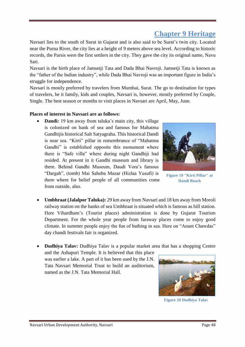
Navsari Urban Development Authority, Navsari Page 48
Chapter 9 Heritage
Navsari lies to the south of Surat in Gujarat and is also said to be Surat’s twin city. Located
near the Purna River, the city lies at a height of 9 meters above sea level. According to historic
records, the Parsis were the first settlers in the city. They gave the city its original name, Navu
Sari.
Navsari is the birth place of Jamsetji Tata and Dada Bhai Navroji. Jamsetji Tata is known as
the “father of the Indian industry”, while Dada Bhai Navroji was an important figure in India’s
struggle for independence.
Navsari is mostly preferred by travelers from Mumbai, Surat. The go to destination for types
of travelers, be it family, kids and couples, Navsari is, however, mostly preferred by Couple,
Single. The best season or months to visit places in Navsari are April, May, June.
Places of interest in Navsari are as follows:
• Dandi: 19 km away from taluka’s main city, this village
is colonized on bank of sea and famous for Mahatma
Gandhijis historical Salt Satyagraha. This historical Dandi
is near sea. “Kirti” pillar in remembrance of “Mahatma
Gandhi” is established opposite this monument where
there is “Safe villa” where during night Gandhiji had
resided. At present in it Gandhi museum and library is
there. Behind Gandhi Museum, Daudi Vora’s famous
“Dargah”, (tomb) Mai Saheba Mazar (Hizlaa Yusufi) is
there where for belief people of all communities come
from outside, also.
• Umbhraat (Jalalpor Taluka): 29 km away from Navsari and 18 km away from Moroli
railway station on the banks of sea Umbhraat is situated which is famous as hill station.
Here Vihardham’s (Tourist places) administration is done by Gujarat Tourism
Department. For the whole year people from faraway places come to enjoy good
climate. In summer people enjoy the fun of bathing in sea. Here on “Anant Chawdas”
day chandi festivals fair is organized.
• Dudhiya Talav: Dudhiya Talav is a popular market area that has a shopping Centre
and the Ashapuri Temple. It is believed that this place
was earlier a lake. A part of it has been used by the J.N.
Tata Navsari Memorial Trust to build an auditorium,
named as the J.N. Tata Memorial Hall.
Figure 19 "Kirti Pillar" at
Dandi Beach
Figure 20 Dudhiya Talav
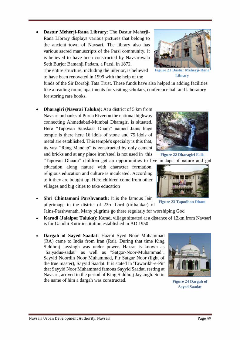
Navsari Urban Development Authority, Navsari Page 49
• Dastur Meherji-Rana Library: The Dastur Meherji-
Rana Library displays various pictures that belong to
the ancient town of Navsari. The library also has
various sacred manuscripts of the Parsi community. It
is believed to have been constructed by Navsariwala
Seth Burjor Bamanji Padam, a Parsi, in 1872.
The entire structure, including the interior, is believed
to have been renovated in 1999 with the help of the
funds of the Sir Dorabji Tata Trust. These funds have also helped in adding facilities
like a reading room, apartments for visiting scholars, conference hall and laboratory
for storing rare books.
• Dharagiri (Navsrai Taluka): At a district of 5 km from
Navsari on banks of Purna River on the national highway
connecting Ahmedabad-Mumbai Dharagiri is situated.
Here “Tapovan Sanskaar Dham” named Jains huge
temple is there here 16 idols of stone and 75 idols of
metal are established. This temple's specialty is this that,
its vast “Rang Mandap” is constructed by only cement
and bricks and at any place iron/steel is not used in this
“Tapovan Dhaam” children get an opportunities to live in laps of nature and get
education along nature with character formation,
religious education and culture is inculcated. According
to it they are bought up. Here children come from other
villages and big cities to take education
• Shri Chintamani Parshvanath: It is the famous Jain
pilgrimage in the district of 23rd Lord (tirthankar) of
Jains-Parshvanath. Many pilgrims go there regularly for worshiping God
• Karadi (Jalalpor Taluka): Karadi village situated at a distance of 12km from Navsari
is for Gandhi Kutir institution established in AD 1950
• Dargah of Sayed Saadat: Hazrat Syed Noor Muhammad
(RA) came to India from Iran (Rai). During that time King
Siddhraj Jaysingh was under power. Hazrat is known as
"Saiyadus-sadat" as well as "Satgor-Noor-Muhammad".
Sayyid Noordin Noor Muhammad, Pir Satgur Noor (light of
the true master), Sayyid Saadat. It is stated in 'Tawarikh-e-Pir'
that Sayyid Noor Muhammad famous Sayyid Saadat, resting at
Navsari, arrived in the period of King Siddhraj Jaysingh. So in
the name of him a dargah was constructed.
Figure 22 Dharagiri Falls
Figure 23 Tapodhan Dham
Figure 24 Dargah of
Sayed Saadat
Figure 21 Dastur Meherji-Rana
Library
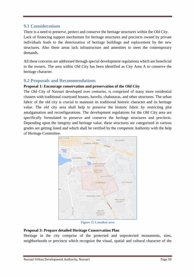
Navsari Urban Development Authority, Navsari Page 50
9.1 Considerations
There is a need to preserve, protect and conserve the heritage structures within the Old City.
Lack of financing support mechanism for heritage structures and precincts owned by private
individuals leads to the deterioration of heritage buildings and replacement by the new
structures. Also these areas lack infrastructure and amenities to meet the contemporary
demands.
All these concerns are addressed through special development regulations which are beneficial
to the owners. The area within Old City has been identified as City Area A to conserve the
heritage character.
9.2 Proposals and Recommendations
Proposal 1: Encourage conservation and preservation of the Old City
The Old City of Navsari developed over centuries, is comprised of many more residential
clusters with traditional courtyard houses, havelis, chabutaras, and other structures. The urban
fabric of the old city is crucial to maintain its traditional historic character and its heritage
value. The old city area shall help to preserve the historic fabric by restricting plot
amalgamation and reconfigurations. The development regulations for the Old City area are
specifically formulated to preserve and conserve the heritage structures and precincts.
Depending upon the integrity and heritage value, these structures are categorized in various
grades are getting listed and which shall be verified by the competent Authority with the help
of Heritage Committee.
Figure 25 Lunsikui area
Proposal 3: Prepare detailed Heritage Conservation Plan
Heritage in the city comprise of the protected and unprotected monuments, sites,
neighborhoods or precincts which recognize the visual, spatial and cultural character of the
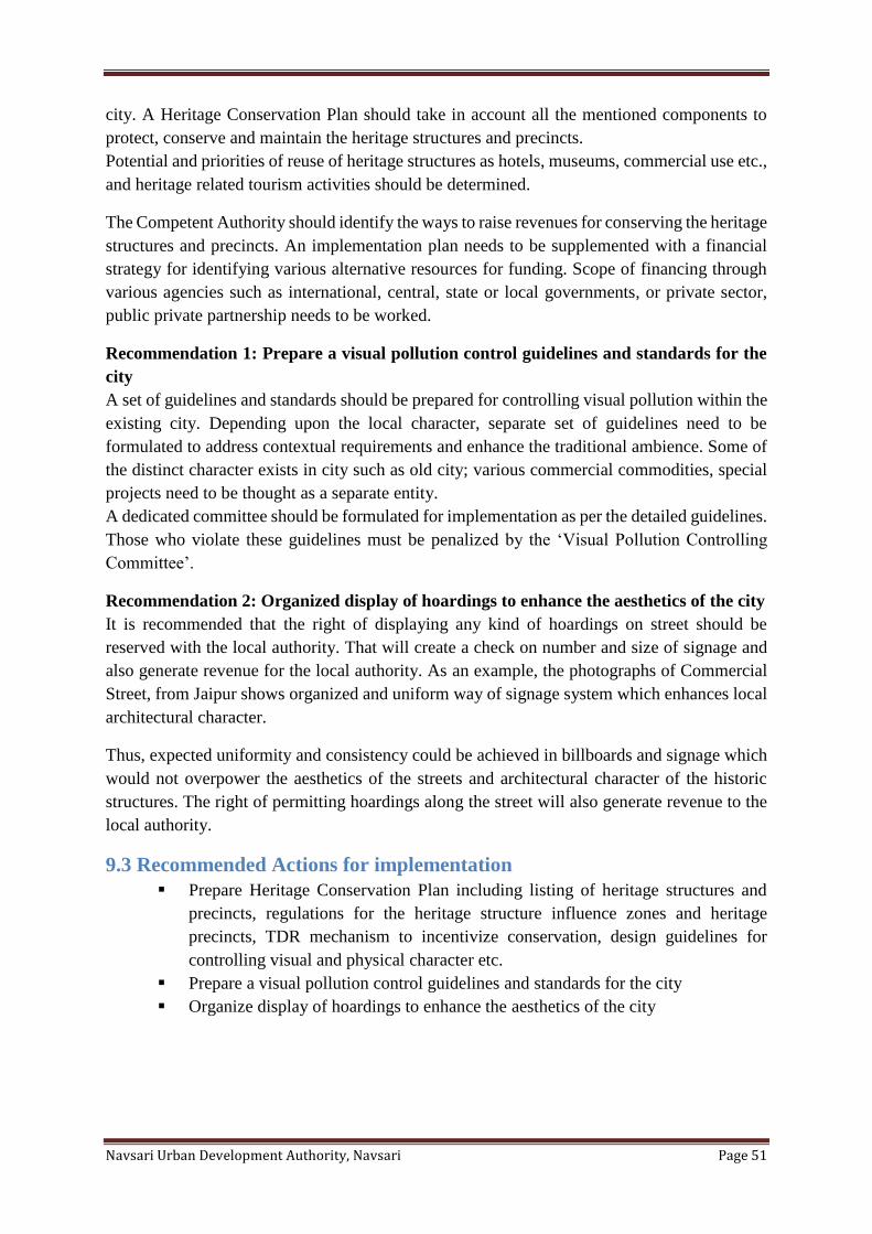
Navsari Urban Development Authority, Navsari Page 51
city. A Heritage Conservation Plan should take in account all the mentioned components to
protect, conserve and maintain the heritage structures and precincts.
Potential and priorities of reuse of heritage structures as hotels, museums, commercial use etc.,
and heritage related tourism activities should be determined.
The Competent Authority should identify the ways to raise revenues for conserving the heritage
structures and precincts. An implementation plan needs to be supplemented with a financial
strategy for identifying various alternative resources for funding. Scope of financing through
various agencies such as international, central, state or local governments, or private sector,
public private partnership needs to be worked.
Recommendation 1: Prepare a visual pollution control guidelines and standards for the
city
A set of guidelines and standards should be prepared for controlling visual pollution within the
existing city. Depending upon the local character, separate set of guidelines need to be
formulated to address contextual requirements and enhance the traditional ambience. Some of
the distinct character exists in city such as old city; various commercial commodities, special
projects need to be thought as a separate entity.
A dedicated committee should be formulated for implementation as per the detailed guidelines.
Those who violate these guidelines must be penalized by the ‘Visual Pollution Controlling
Committee’.
Recommendation 2: Organized display of hoardings to enhance the aesthetics of the city
It is recommended that the right of displaying any kind of hoardings on street should be
reserved with the local authority. That will create a check on number and size of signage and
also generate revenue for the local authority. As an example, the photographs of Commercial
Street, from Jaipur shows organized and uniform way of signage system which enhances local
architectural character.
Thus, expected uniformity and consistency could be achieved in billboards and signage which
would not overpower the aesthetics of the streets and architectural character of the historic
structures. The right of permitting hoardings along the street will also generate revenue to the
local authority.
9.3 Recommended Actions for implementation
▪ Prepare Heritage Conservation Plan including listing of heritage structures and
precincts, regulations for the heritage structure influence zones and heritage
precincts, TDR mechanism to incentivize conservation, design guidelines for
controlling visual and physical character etc.
▪ Prepare a visual pollution control guidelines and standards for the city
▪ Organize display of hoardings to enhance the aesthetics of the city
Navsari Urban Development Authority, Navsari Page 52
Chapter 10 Environment Due to the rapid growth of population and urbanization, the environment quality is fast
degrading. As a result, it is leading to further deterioration of conditions and over extraction of
resources. This chapter is focused on the improvement in the environmental conditions of the
city to sustain the fast growth of population.
10.1 Considerations
As mentioned in existing condition following are the major issue and observations of existing
environmental quality of the city
▪ There is a constant need to preserve natural elements like water bodies, ravines and
eco‐sensitive areas.
▪ With the pace of development there is a need to take higher precautions to maintain
the air quality in the city due to high vehicular growth and industrialization.
▪ The untreated waste water from commercial and industrial sectors is disposed into
the natural water bodies leading to water pollution.
▪ The levels of noise have been constantly increasing due to the increase in the
vehicles on the road.
▪ Incompatible land uses, for example party plots located in residential areas, mall or
a market places nearby the institutions cause noise pollution.
▪ Due to the hard and reflective surfaces in urbanized areas heat effect can be seen
through the climate change in the city.
10.2 Proposals and Recommendations
Below are the set of proposals and recommendations grouped by various issues to address; air
quality, water quality, noise level, visual quality, eco‐sensitive areas, heat, energy efficiency
and climate change.
10.2.1 Incentivizing Green development
Proposal 1: Encourage energy efficient buildings
In order to encourage construction of energy efficient buildings, special regulations and
incentives have been introduced in the revised Development Regulations. These include
▪ Any energy efficient building having a certificate from GRIHA (Green Rating for
Integrated Habitat Assessment) or any other Government recognized Institute, shall
be eligible for incentives in the rate of premium FSI up to 5%.
▪ Provision of solar assisted water heating system in Hospital & Nursing Homes,
Hotels, Lodges and Guest Houses, Hostels of schools, colleges, training centers,
Community centers and Banquet Halls
▪ On the external wall of any building, maximum 50% of the surface area of the wall
can be covered by sun reflecting material/ reflecting glass, with the provision of
safety railing up to sill level.
10.2.2 Water Quality and water resource management:
Rapid urbanization and industrialization are the vital causes of deterioration in water quality
and depletion of water resources in the city. The untreated water effluent from polluting
industries, inadequate infrastructure network and untreated disposal of sewerage and storm
Navsari Urban Development Authority, Navsari Page 53
water are the major causes behind the degradation of ground water and surface water quality.
Following are the recommendations for the improvement in water quality and water resource
management in future.
Proposal 2: Ground water recharge through Recharge wells
Ground water recharge has been proposed through development of Recharge wells, Retention
ponds, Rainwater harvesting systems etc. For this, suitable regulations have been introduced in
the GDCR as well. Also, lake linkages schemes shall be carried out to further increase
groundwater level
Recommendation 1: Recycle and Reuse of waste water
Recycling and reuse of waste water should be encouraged as recycled water can satisfy most
water demands, as long as it is adequately treated to ensure water quality appropriate for the
use. Recycled water is most commonly used for non-potable (not for drinking) purposes, such
as agriculture, landscape, public parks, toilet flushing, dust control, construction activities, etc.
By providing an additional source of water, water recycling can help us find ways to decrease
the diversion of water from sensitive ecosystems. Other benefits include decreasing wastewater
discharges and reducing and preventing pollution.
Recommendation 2: Controlling water quality through strict monitoring and
enforcement of regulations
NUDA and Navsari Municipality to work with GPCB to identify/develop mechanism to
monitor quality of ground water, water in lakes and rivers on regular basis and also rank the
water sourced based on their quality
10.2.3 Air Quality
Looking at the existing air quality situation and pace of urbanization, long term and time bound
strategies should be formulated to achieve healthy and safe air environment in future.
Motorized vehicles and industries are the major sources of air pollution in the city. Apart from
that, addition of dust particles into the air is another means of air pollution. Following are
recommended measures to overcome the air quality issue in future.
Recommendation 3: Controlling vehicular emission
With the population growth and economic development, there is a rapid increase in private
motorized vehicles in the city. Along with the high vehicular volume, poor condition of the
vehicles, use of polluting nonrenewable fuel and also slow and congested traffic flow are the
major causes behind the increase in air pollution due to vehicular emission.
There are two parts to controlling pollution from vehicular emission ‐ improvement through
vehicle and fuel technology and reduction in vehicular travel. To control this situation the
following measures are recommended
▪ Strict enforcement of PUC standards for all vehicles
▪ Providing and encouraging public transport, pedestrianization and non‐motorized
transport instead of motorized private vehicular mode
▪ Promoting and incentivizing use of low pollution generating renewable energy fuel
▪ Ensuring smooth flow of traffic
Navsari Urban Development Authority, Navsari Page 54
▪ Restricting use of very old and dilapidated vehicles
Recommendation 4: Controlling Industrial emissions
Industries are a crucial part of the city’s economic growth and development. However,
existence of industries and related activities can be a major cause of degradation of air and
water quality. Segregating such heavy industries from other residential and commercial areas
is important for health and safety of people living in the urban areas. This shall be facilitated
through the zoning regulations of the Development Plan. However, strict enforcement of
pollution controlling standards is crucial for industries in urban and rural areas. It is expected
that there should not be any adverse effect on the surrounding atmosphere due to emission from
such industries and commercial activities.
Compulsory air filtration and purification is recommended before releasing it into the
atmosphere. Also, it is recommended to develop continuous and thick rows of foliaged trees
which will act as an absorptive screen for pollutants. Specific foliaged trees and land for tree
plantation need to be identified for such green buffer development.
Recommendation 5: Reducing suspended particulate matter in air
Due to hot and dry climate, flat topography and type of ground surface, the city faces
considerable dust pollutants in air. Higher amount of such particles in air can cause issues
related to breathing and respiratory diseases. Also, they capture and contain heat and contribute
in urban heat island effect. Therefore, it is important to treat the exposed earth surfaces through
provision of green cover, permeable pavement or other such technologies.
The proposal to develop ‘complete streets’ would help cover such exposed surfaces along city
streets and amount of dust particles in the air due to vehicular movement. Provision of green
cover on open plots by creation of plazas, pocket parks and gardens will also help tremendously
to reduce the suspended particulate matter in air. It is also recommended to encourage private
land owners to develop their land with hard and soft landscape and offer them incentives for
the same.
10.2.4 Noise
Commercial areas in Navsari city reach up to 63‐68db, and residential areas reach up to 55‐60
db, which is higher than the limit suggested by GPCB. (60 db for commercial and 40 db for
residential areas) Following measures are suggested to control the increasing noise pollution
in a city.
Recommendation 6: Identifying ‘no honking / silence zone’
Identify and demarcate ‘No Honking zone’/ ‘silence zone’ around noise sensitive areas like
hospitals, educational institutions, zoo, special areas like Gandhi Ashram, High Court, etc. with
appropriate signage system all over the city. A set of guidelines and policy should be prepared
for effective implementation and enforcement of such ‘silence zone’.
Recommendation 7: Controlling noise levels during night time
As per the standards, maximum noise level during nighttime is less than that in day i.e. during
day time, noise level is 55 db and during night time should not be more than 45 db in residential
Navsari Urban Development Authority, Navsari Page 55
areas. Controlling noise level during nighttime is very crucial. Thus noise generated from party
plots, club house, loud speakers because of festivals and events during the night time should
be monitored and controlled by local enforcement.
10.3 Recommended Actions for implementation
Below is a combined list of recommended action points to preserve and maintain the quality of
environment in NUDA area
▪ Implementation of urban environment monitoring program, that monitors air
quality, water quality, noise level and heat island effects in the urban areas on
regular intervals.
▪ Active initiatives should be taken to generate awareness about urban environment
issues within the citizen of the city
▪ Strict enforcement of PUC standards for all motorized vehicles
▪ Reduction of SPM is air by treating exposed land surface by green cover,
landscaped surfaces, permeable pavers and other such techniques.
▪ Compulsory treatment of waste water generated in industries before releasing it
into the natural water bodies.
▪ Identification and demarcation of ‘no honking zone’ or ‘silence zone’
▪ Strict enforcement for controlling high noise level during night time
Navsari Urban Development Authority, Navsari Page 56
Chapter 11 Implementation of Development Plan 11.1 Introduction
Success of Development Plan depends on how effectively it is implemented. Various tools
identified for its implementation include Comprehensive General Development Regulations,
projects, proposals, detailed plans and implementation and monitoring. These tools will require
certain mechanisms through which they can be carried out. Such mechanisms include town
planning schemes, network road plan, public private partnerships, and dedicated team to
prepare and monitor detailed projects.
11.2 Implementation Tools
Below are the tools that can be deployed to implement various aspects of the Development
Plan
i. Comprehensive General Development Control Regulations(CGDCR)
ii. Implementation of projects
iii. Implementation of proposals
iv. Preparation of Detailed Plans and Studies and other improvements
v. Creation of Resource Cell
11.2.1 Comprehensive General Development Control Regulations (CGDCR)
Comprehensive General Development Control Regulations are important tools to regulate the
use of land and the urban form of the city while ensuring safe, healthy and livable urban
environment. In order to implement the Draft Development Plan 2039 in accordance with the
overarching vision and the principles of growth management, the CGDCR are suitably
modified. The revised CGDCRs have also been simplified and illustrated as necessary to make
them easy to interpret and implement. The revised CGDCRs are structures in five sections as
follows:
Section A: Introduction and definitions
Section B: Procedure Regulations
Section C: Planning Regulations
Section D: Building performance regulations
Section E: Schedules and forms
Following are some of the major features of the revised CGDCRs
Procedural Regulations:
These regulations mandate the procedures and requirements for construction of building sand
for obtaining development permission and building use permission. Salient features included
in this section are as follows
▪ Requirement for landscape plan along with building plan approval
▪ Registration of fire protection consultants
▪ All sanctioned building plan to be published on website of the authority
▪ Revision in different kind of fees,
▪ Improved check‐list for scrutiny
Navsari Urban Development Authority, Navsari Page 57
Planning Regulations:
This section consists of Regulations pertaining to land use, density, height and setbacks of
building and parking requirement. Salient features included in this section are as follows
▪ Simplified and improved zoning nomenclature that organizes the zoning categories
to better reflect the uses they are intended for.
▪ FSI incentives for development
▪ Introduction of Gamtal Extension zone to incentivize compact development within
the central areas
▪ Introduction of Transit Corridor to encourage compact development
▪ To incentivize development of affordable housing, Residential – Affordable
Housing policy has been incorporated
▪ Enhanced Regulations for affordable housing
▪ Specific area/zone for Old City to encourage conservation and preservation of the
Old City
▪ Enhanced Regulations for heritage to incentivize preservation of listed heritage
structures
▪ Enhanced Regulations for development of Gamtal Extension areas
Building Performance Regulations:
These regulations define minimum performance standards and specifications that buildings are
required to comply with. Salient features are as follows
▪ Fixed margins:
o Fixed Road Margins (Build‐to‐line) based on road width resulting into a
uniform street facade and harmonious urban form
o Revised and fixed other than roadside margins based on building height range
to increase the use of ground space and at the same time meeting the fire safety
requirements
o Removal of ground coverage restrictions allowing full utilization of ground
space subject to margin, common plot and parking regulations
o Improved parking requirements: removed restrictions on number of cellars or
number of floors for parking purpose
o Parking area not included in FSI requirement
▪ Building height
o Revision of building height classification to enable optimum utilization of FSI
o Building height considered from ground level
o Buildings to be classified based on height range
o Improved norms for fire safety related to fire
▪ Improved norms for fire safety related to fire exit routes
▪ Expanded scope for requirements related to disabled persons
▪ Introduction of rainwater storage requirement and grey water recycling
requirements
▪ Enhanced rainwater harvesting requirement with provision of retention ponds for
larger developments
▪ Incentives for Green Buildings
Navsari Urban Development Authority, Navsari Page 58
11.2.2 Projects
These projects typically include construction and development activities proposed, such as
transportation, physical infrastructure, social infrastructure, green network and housing. They
may require capital investments and may require the need to prepare Detailed Project Reports
(DPR).
Following are the list of projects to be constructed and developed as identified in this Draft
Development Plan 2039.
Transportation:
▪ Existing Road Network 3.09 Sq.km
▪ Expansion of Road Network – 1.76 sq.km
▪ Other Detail
No. Type NUDA
1 Bridge over River 5
Green Network
Development of regional, city level and neighborhood level parks and public plazas ‐ 78.46
hectares
▪ Development of Green street network implemented along with Complete Streets
▪ Lake front, Riverfront and Canal front development
▪ Development of Urban groves to increase green cover
▪ Utilization of underutilized spaces such as bridge under space
Social Infrastructure
▪ Development of Fire Stations
Physical Infrastructure:
▪ Up gradation of water treatment plants (WTPs) ‐
▪ Up gradation and provision of New Sewage Treatment Plants (STP) –
▪ Enhancement of Storm water drainage network coverage
▪ Lake linkages for managing storm water and ground water recharge
▪ Up gradation of landfill site
11.2.3 Proposals
Following are the proposals to be implemented as identified in the Revised Draft Development
Plan 2039.
Zoning
▪ Re-densification of existing zoned areas
Social Infrastructure
▪ Encourage development of educational and research facilities
▪ Provision of land for educational facilities through Town Planning Mechanism
▪ Provision of land for fire and emergency services through Town Planning
Mechanism
Navsari Urban Development Authority, Navsari Page 59
▪ Provision of land for recreational facility through Town Planning Mechanism
Economic Development
▪ Organize informal sector
▪ Enable and support industrial growth center sand corridors
▪ Support rural economy
▪ Organize employment centers and corridors for sustainable economic development
11.2.4 Detailed Plans, Studies and other improvements
Following are some of the recommended plans, studies and other improvements proposed to
be conducted by the Authority’s Resource Cell for effective implementation of the proposals
identified
[A] Plans and studies
▪ Zoning
o Guidelines for Network road plan
o Guidelines for new TP schemes
▪ Transportation and Mobility
o Parking Management Plan and individual Parking Zone Plans
o Trip General manual for Navsari
o Paring generation manual for Navsari
o Signage and Way finding plan
o Comprehensive freight management plan
▪ Green Network
o Green Network Plan
o Comprehensive Lake Development Plan
o Lakefront Development Plans (for individual lakes)
▪ Physical Infrastructure
o Physical Infrastructure Development and Management Plans
o GIS database for physical Infrastructure
▪ Economic Development
o Plan to organize and manage informal sector
o Prepare and maintain database of existing employment by various categories and
location to assess job‐housing balance, travel demand and infrastructure demand
▪ Heritage
o Heritage Conservation Plan including listing of heritage structures and precincts,
regulations for the heritage structure influence zones and heritage precincts, TDR
mechanism to incentivize conservation, design guidelines for controlling visual and
physical character etc.
o Specific Paring Management Plan for Old City to support CGDCR
Navsari Urban Development Authority, Navsari Page 60
[B] Procedural changes
▪ Improvements in building permission records database to include additional
information
▪ Online database for all sanctioned building plans
[C] Interdepartmental programs
▪ Urban environment monitoring program to monitors air quality, water quality,
noise level and heat island
11.2.5 Creation of Resource Cell
The proposals in the Revised Draft Development Plan 2039 have been formulated considering
20 years horizon. However, to evaluate the progress made towards achieving the vision, a
Resource Cell shall be set up to enhance and implement the proposals and projects. It will be
responsible for coordinating and integrating various projects and proposals and for creating a
coherent, livable urban environment. It shall comprise of a Planning and Research Unit and an
Implementation Monitoring Unit.
[A] Planning and Research Unit:
Planning and Research unit shall be equipped with modern data processing facilities, software,
and modern surveying equipment such as GPS etc. It shall comprise of a team of engineers,
planners, administrative officials and other relevant professionals. It shall also prepare various
plans and conduct studies, research and consultancy. It shall identify various projects to be
implemented and empanel professional organizations which shall further assist the Resource
Cell in carrying out various studies for the projects identified.
[B] Monitoring Unit:
Monitoring unit shall be set up for monitoring the progress and implementation of various
projects. For this, measurable indicators need to be identified to monitor the physical and socio‐
economic changes made. Monitoring shall be done in two phases of 5years each. At the end of
the first phase, implementation of the plan shall be reviewed, growth rates and economic
conditions be assessed and necessary recommendations made for any modifications or
revisions.
11.3 Implementation Mechanisms
Below are the mechanisms that can be deployed to implement various aspects of the
Development Plan.
[A] Implementation mechanism for construction and development projects
a. by authority
b. Joint Ventures/Public Private Partnership (PPP)
[B] Implementation mechanism for zoning and land development proposals
a. Town Planning Schemes (T.P. Schemes)
b. Network road plan
c. Comprehensive General Development Regulations
[C] Implementation mechanism for plans and studies and other improvements
Navsari Urban Development Authority, Navsari Page 61
Chapter 12 Costing and Resource Mobilization 12.1 Cost Estimation
Implementation of projects, proposals, plans, studies and improvements identified in the
Revised Draft Development Plan 2039 will require resources and funds for implementation.
Below is a broad estimate of costs for implementation of this Development Plan broken down
into four broad components.
▪ Implementation of projects
▪ Implementation of proposals
▪ Preparation of Detailed Plans, Studies and other Improvements (database
preparation, procedural changes, interdepartmental changes)
▪ Creation of Resource Cell
▪ Each of these components has been detailed out in this section.
12.1.1 Implementation of projects (Construction and Development)
Due to the rapid growth of population within the city and the expansion of developed areas
there is a need for constant up gradation and expansion of the infrastructure facilities. The
expansion area of NUDA needs to be provided with organized infrastructure i.e. roads, water
supply, sewerage, storm water, parks, open spaces etc. Therefore, the Revised Draft
Development Plan 2039 introduces several plans, proposals and recommendations taking into
consideration the future population growth for improvement in transportation, physical
infrastructure and green network.
The cost of implementation of projects has been calculated considering the following
components which have been detailed further in this section
[A] Transportation
[B] Green Network
[C] Physical infrastructure
[A] Transportation
Various proposals have been developed to help address existing transportation issues impacting
mobility and for improving future conditions by improving the network, setting priorities right,
and managing travel demand. The transportation cost includes the following cost components
▪ Construction of Roads
▪ Construction of bridges
▪ Provision of street light
▪ Implementation of On‐street Parking System for Parking Zones
The cost breakup for each of the above mentioned component has been detailed out in the tables
below
Table 6 Cost break up for Construction of Roads
Area Proposed Road area (sq.km) Cost (Rs. In Cr)
NUDA 1.76 433.92
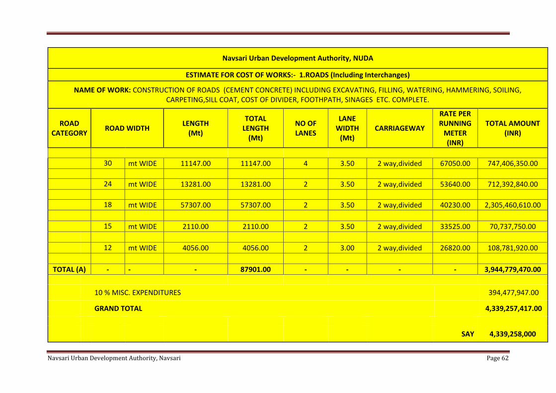
Navsari Urban Development Authority, Navsari Page 62
Navsari Urban Development Authority, NUDA
ESTIMATE FOR COST OF WORKS:- 1.ROADS (Including Interchanges)
NAME OF WORK: CONSTRUCTION OF ROADS (CEMENT CONCRETE) INCLUDING EXCAVATING, FILLING, WATERING, HAMMERING, SOILING, CARPETING,SILL COAT, COST OF DIVIDER, FOOTHPATH, SINAGES ETC. COMPLETE.
ROAD CATEGORY
ROAD WIDTH LENGTH
(Mt)
TOTAL LENGTH
(Mt)
NO OF LANES
LANE WIDTH
(Mt) CARRIAGEWAY
RATE PER RUNNING
METER (INR)
TOTAL AMOUNT (INR)
30 mt WIDE 11147.00 11147.00 4 3.50 2 way,divided 67050.00 747,406,350.00
24 mt WIDE 13281.00 13281.00 2 3.50 2 way,divided 53640.00 712,392,840.00
18 mt WIDE 57307.00 57307.00 2 3.50 2 way,divided 40230.00 2,305,460,610.00
15 mt WIDE 2110.00 2110.00 2 3.50 2 way,divided 33525.00 70,737,750.00
12 mt WIDE 4056.00 4056.00 2 3.00 2 way,divided 26820.00 108,781,920.00
TOTAL (A) - - - 87901.00 - - - - 3,944,779,470.00
10 % MISC. EXPENDITURES 394,477,947.00
GRAND TOTAL 4,339,257,417.00
SAY 4,339,258,000
Navsari Urban Development Authority, Navsari Page 63
The total cost of transportation infrastructure is estimated to be Rs. 433.92 crores.
No. Type NUDA
1 Bridge over River 5
[B] Green Network
In order to cater to the needs of the neighborhoods in the city, a various projects have been
planned to provide adequate recreational spaces. The Green network cost includes
▪ Development of Gardens
▪ Development of Lakes
As we proposed 78.46 Ha of land for recreation zone, on the bases of that the overall costing
for developing gardens in Navsari Municipality and NUDA area is estimated to be Rs. 39
crores.
[C] Physical Infrastructure
The total cost to be incurred for up gradation and provision of physical infrastructure has-been
calculated taking into account the various cost components of sewerage system.
▪ Sewerage cost
The cost estimate for sewage infrastructure includes
o Sewage treatment plants
o Intermediate Pumping stations
o Sewage network
Table 7 Estimation of Drainage Work
Navsari Urban Development Authority, NUDA
ESTIMATE FOR COST OF WORKS:- 3 DRAINAGE WORKS
NAME OF WORK: PROVIDING AND LAYING OF APPROPRIATE SIZE DRAINAGE LINE
INCLUDING TREATMENT PLANT ETC. COMPLETE
Sr.No. DESCRIPTION Population
(2031)
UNIT
Per
RATE (INR) Per
Capita
AMOUNT
(INR)
1 PROVIDING UNDERGROUND
DRAINAGE LINES OF R.C.C.
NP3 CLASS PIPES ON
PROPOSED MAIN
,SECONDARY ROAD
INCLUSIVE OF EXCAVATION,
REFILLING, CONSTRUCTION
OF BRICK MASONRY
MANHOLES WITH FIBER
REINFORCED COVERS AND
SEATS AND PUMPING
STATION, SEWERAGE
TREATMENT PLANT
316599 Ha 6000.00 1899594000.00
sssssTOTAL
………………….(A) 1899594000.00
10 % MISC. EXPENDITURES
189959400
GRAND TOTAL
2089553400
SAY 2,089,554,000
Electrical Street Lighting
Electrical line is proposed with light pole along with the road width which is as shown
in table given bellow.
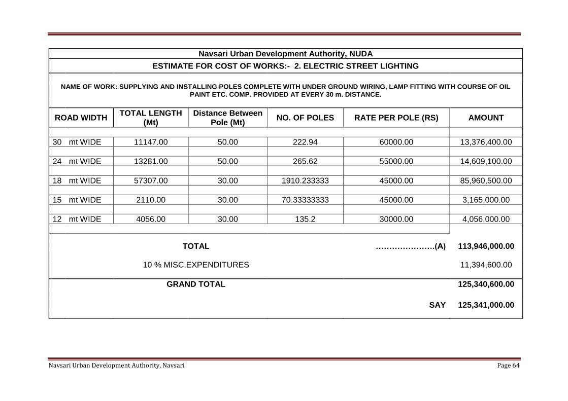
Navsari Urban Development Authority, Navsari Page 64
Navsari Urban Development Authority, NUDA
ESTIMATE FOR COST OF WORKS:- 2. ELECTRIC STREET LIGHTING
NAME OF WORK: SUPPLYING AND INSTALLING POLES COMPLETE WITH UNDER GROUND WIRING, LAMP FITTING WITH COURSE OF OIL
PAINT ETC. COMP. PROVIDED AT EVERY 30 m. DISTANCE.
ROAD WIDTH TOTAL LENGTH
(Mt) Distance Between
Pole (Mt) NO. OF POLES RATE PER POLE (RS) AMOUNT
30 mt WIDE 11147.00 50.00 222.94 60000.00 13,376,400.00
24 mt WIDE 13281.00 50.00 265.62 55000.00 14,609,100.00
18 mt WIDE 57307.00 30.00 1910.233333 45000.00 85,960,500.00
15 mt WIDE 2110.00 30.00 70.33333333 45000.00 3,165,000.00
12 mt WIDE 4056.00 30.00 135.2 30000.00 4,056,000.00
TOTAL ………………….(A) 113,946,000.00
10 % MISC.EXPENDITURES 11,394,600.00
GRAND TOTAL 125,340,600.00
SAY 125,341,000.00
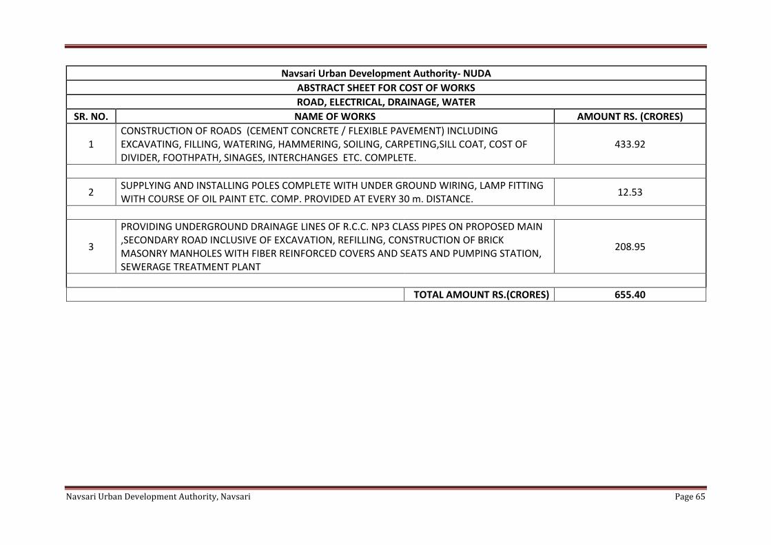
Navsari Urban Development Authority, Navsari Page 65
Navsari Urban Development Authority- NUDA
ABSTRACT SHEET FOR COST OF WORKS
ROAD, ELECTRICAL, DRAINAGE, WATER
SR. NO. NAME OF WORKS AMOUNT RS. (CRORES)
1 CONSTRUCTION OF ROADS (CEMENT CONCRETE / FLEXIBLE PAVEMENT) INCLUDING EXCAVATING, FILLING, WATERING, HAMMERING, SOILING, CARPETING,SILL COAT, COST OF DIVIDER, FOOTHPATH, SINAGES, INTERCHANGES ETC. COMPLETE.
433.92
2 SUPPLYING AND INSTALLING POLES COMPLETE WITH UNDER GROUND WIRING, LAMP FITTING WITH COURSE OF OIL PAINT ETC. COMP. PROVIDED AT EVERY 30 m. DISTANCE.
12.53
3
PROVIDING UNDERGROUND DRAINAGE LINES OF R.C.C. NP3 CLASS PIPES ON PROPOSED MAIN ,SECONDARY ROAD INCLUSIVE OF EXCAVATION, REFILLING, CONSTRUCTION OF BRICK MASONRY MANHOLES WITH FIBER REINFORCED COVERS AND SEATS AND PUMPING STATION, SEWERAGE TREATMENT PLANT
208.95
TOTAL AMOUNT RS.(CRORES) 655.40
Navsari Urban Development Authority, Navsari Page 66
12.1.2 Preparation of detailed plans and studies
Implementation of the Revised Draft Development Plan will require multiple studies,
guidelines and plans to be prepared for effective and successful implementation. Guidelines
for preparing Network road plan, Design of Complete Streets, Parking Management Plan,
Green Network Plan, Traffic Management Plan, Traffic Surveys and Travel Demand
Modeling, Lake Development Plans, Heritage Conservation Plan, Pedestrian and bicycle
network etc. are some examples of such plans and studies.
Total cost of such plans and studies are estimated to be about Rs. 660 crores over the next
decade.
12.1.3 Database Preparation and procedural changes
Learning from the past, the development plan recommends updating various procedures and
creating and maintaining crucial databases. This includes preparing and maintaining housing
unit survey and database, GIS database for physical infrastructure including water, sewage,
storm water etc., building and maintaining employment database, parking surveys and database
etc.
The procedural changes shall include improvements in building permission records database
to capture additional information, online database for all sanctioned building plans,
enhancement of resources and capacity building of existing units to ensure effective
implementation etc.
12.1.4 Resource cell
As discussed earlier, a Resource Cell is proposed to be formed for implementation and
monitoring of the progress of various projects, preparation of various plans and conducting
studies and research as a part of Development Plan. The total cost for Resource cell includes
the following components
▪ [A] Planning and Research Unit
o Infrastructure set up cost
o Manpower cost (10 years)
▪ [B] Implementation monitoring unit
o Infrastructure set up cost
o Manpower cost (10 years)
The total cost for setting up Research cell is Rs. 40 crores.
12.1.5 Total cost for Revised Draft Development Plan
Putting all the costs together, the total cost of Revised Draft Development Plan 2039 is been
estimated to be about Rs. 700 crores.
12.2 Resource Mobilization
The implementation of the Development Plan requires long-term fiscal planning. Following
are some of the modes through which resources could be generated for covering the costs
Navsari Urban Development Authority, Navsari Page 67
incurred for implementation of the various projects, proposals and improvements identified in
the Revised Draft Development Plan 2039.
12.2.1 Self-funding by Authority
▪ Revenues from Development Fees
▪ Land Resources / Sale of Public land
▪ Payment from saleable FSI
▪ Various fees for urban services such as water supply, drainage, roads etc. (under
sec 23 of the Act)
▪ Development charges from the citizens for development of land (under sec. 99 and
100 of the Act)
12.2.2 Funding from State Government
The funds generated by Authority will be inadequate for major capital projects proposed under
Development Plan 2039. Therefore, additional funding shall be required to be sourced by the
grants and loans from the state government.
12.2.3 Funding from Central Government
The Government of India has proposed substantial assistance through the JnNURM under
which funds shall be provided for proposals that would meet the Mission’s requirements.
Assistance under JnNURM is additional central assistance, which would be provided as grant
to the implementing agencies.
12.2.4 Leveraging funding from other agencies and departments
Apart from the various State and central government financial assistance, Authority can seek
funding for proposals from various organizations such as LIC, HUDCO, World Bank etc.
12.2.5 Joint Ventures/Public Private Partnership (PPP)
In order to optimize life cycle costs, private sector efficiencies can be inducted in development,
management, implementation and financing of proposals and projects proposed in the Revised
Draft Development Plan 2039 through Joint Ventures or Public Private Partnership (PPP)
arrangements where appropriate.
Private sector involvement may be sought for the following
▪ Construction of affordable housing,
▪ Infrastructure development such as construction of roads, public transit systems,
logistics Parks, parking management
▪ Garden and Waterfront development
▪ Physical infrastructure such as water supply, solid waste management etc.
Navsari Urban Development Authority, Navsari Page 68
Chapter 13 Recommended Actions Following are some of the recommended actions that can be taken up as immediate steps as a
part of implementation of the Revised Draft Development Plan 2039.
13.1 Projects
Transportation
▪ Existing Road Network 3.09 sq.km
▪ Expansion of Road Network – 1.76 sq.km
Green Network
▪ Development of Green street network implemented along with Complete Streets
▪ Lake front, Riverfront and Canal front development
▪ Development of Urban groves to increase green cover
▪ Utilization of underutilized spaces such as bridge under space
Physical Infrastructure
▪ Up gradation and provision of New Sewage Treatment Plants (STP) – 1 nos.
▪ Enhancement of Storm water drainage network coverage
▪ Lake linkages for managing storm water and ground water recharge
13.2 Implementation of Proposals
Following are the proposals to be implemented as identified in the Revised Draft Development
Plan 2039.
Zoning
▪ Re-densification of existing zoned areas
Social Infrastructure
▪ Encourage development of educational and research facilities through provision of
Knowledge and Institution Zone
▪ Provision of land for educational facilities through Town Planning Mechanism
▪ Provision of land for fire and emergency services through Town Planning
Mechanism
▪ Provision of land for recreational facility through Town Planning Mechanism
Economic Development
▪ Organize informal sector
▪ Enable and support industrial growth center sand corridors
▪ Support rural economy
▪ Organize employment centers and corridors for sustainable economic development
13.3 Preparation of Detailed Plans, studies and other improvements
Following are some of the recommended plans, studies and other improvements proposed to
be conducted by the Authority’s Resource Cell for effective implementation of the proposals
identified

Navsari Urban Development Authority, Navsari Page 69
[A] Plans and studies
▪ Zoning
o Guidelines for Network road plan
o Guidelines for new TP schemes
▪ Transportation and Mobility
o Comprehensive set of guidelines for designing and implementing a ‘Complete
Street’
o Parking Management Plan and individual Parking Zone Plans
o Trip General manual for Navsari
o Paring generation manual for Navsari
▪ Green Network
o Green Network Plan including planning of Vistas
o Comprehensive Lake Development Plan
o Lakefront Development Plans (for individual lakes)
▪ Physical Infrastructure
o Physical Infrastructure Development and Management Plans
o GIS database for physical Infrastructure
▪ Economic Development
o Plan to organize and manage informal sector
o Prepare and maintain database of existing employment by various categories and
location to assess job‐housing
o balance, travel demand and infrastructure demand
▪ Heritage
o Heritage Conservation Plan including listing of heritage structures and precincts,
regulations for the heritage structure influence zones and heritage precincts, TDR
mechanism to incentivize conservation, design guidelines for controlling visual and
physical character etc.
[B] Procedural changes (in record keeping systems (digital& manual forms), fees etc.)
▪ Improvements in building permission records data base to include additional
information
▪ Online database for all sanctioned building plans
[C] Interdepartmental programs (monitoring programs etc.)
▪ Urban environment monitoring program to monitors air quality, water quality, noise
level and heat island effects in the urban areas on regular intervals.
13.4 Creation of Resource Cell
▪ For monitoring plan implementation
Navsari Urban Development Authority, Navsari Page 70
▪ Coordinating between various department and authorities for implementation of
DP
▪ Carrying out various studies and planning exercises
▪ Implementing procedural and other improvements etc.
Navsari Urban Development Authority, Navsari Page 71
APPENDIX APPENDIX 1.A – BASIS FOR POPULATION PROJECTIONS
PROJECTION METHODOLOGY
Considering the trends of population growth during the past four decades, the future profile of
the city in terms of population has been worked out. The development Plan is for the period of
10 years, for the consideration of the projects a time period of 20 years is considered thus the
population projects is done for a period of 10 and 20 years respectively for the years of 2021,
2031 and 2039. In order to be more realistic in terms of estimating the future population of the
town, 3 different methods have been used. The methods used for the population projections
are:
a) Arithmetical progression method
b) Geometrical progression method
c) Incremental increase method
Considering the large variations of population arrived at by these methods, average of the
figures are proposed to be adopted for working out the population distribution, land use
planning, infrastructure requirement and transportation network required to serve the
population.
Population Projection through Arithmetical Progression Method:
The increment in the population per decade is averaged out and it is multiplied with the number
of decades for which the projection is required to be done, this averaged increment is applied
to the population of base year i.e. 2011 and the projection for the year 2021, 2031 and 2039 is
calculated.
Projected Population for year 2021 =
Population in 2001+ (1 x average increase per decade)
Projected Population for year 2031 =
Population in 2011+ (2 x average increase per decade)
Projected Population for year 2041 =
Population in 2011+ (3 x average increase per decade)
Population Projection through Geometrical Progression Method:
For projecting the population through Geometric Progression Method, a Geometric mean of
the past growth rates is derived, now assuming that the future growth for the decades of 2021,
2031 and 2039 follows the geometric mean. Taking the population of the year 2011 as the base
year the geometric mean is applied to the population of the base year and the population is
projected for the upcoming 3 decades.
Geometric mean, rg= (Growth rate of 1st and 2nd decade x Growth Rate 2nd and 3rd decade x
Growth rate of 2nd and 3rddecade) ^ (1/3)
Navsari Urban Development Authority, Navsari Page 72
Projected Population for year 2021 = Population in 2011 X (1 + rg) ^ 1
Projected Population for year 2031 = Population in 2011 X (1 + rg) ^ 2
Projection Population for year 2041 = Population in 2011 X (1 + rg) ^ 3
Population Projection through Incremental Increase Method:
For projecting the population through Incremental Increase Method, the difference between the
increments is calculated which is called the incremental increase, which is then averaged out
and applied to the Base year of 2001 and the projection for the year 2011, 2021 and 2031 are
calculated.
Incremental Increase Pn = P1 + nX + n (n+1) Y/2
Where,
Pn is the Projected Population for that particular decade
P1 is the population for the base year i.e. 2001
n is the decade for which the population projection is to be done
X is the average increase in population per decade
Y is the average incremental increase of the decades
APPENDIX 3.2. A – NETWORK ROAD PLANNING
A Development Plan consists of a broad framework of overall vision, policies, proposals and
regulations for the urban area of Navsari for future development up to next 20 years. This
development Plan is implemented on ground through various tools. Historically, these tools
have included T.P. schemes and development control regulations (GDCR) specified for various
zones. These tools primarily are focused on guiding new developments. However, there is a
significant need to do micro level planning for improving existing developed areas.
Network Road Planning is proposed to be one such micro level planning tool that will help
implement the vision of Development Plan on plot to plot basis taking into account the needs
of the existing ward/ neighborhood or any area within NUDA. This shall be achieved by
instantaneous proposal of a Public road at the time of receiving Development Permission, after
thoroughly studying existing Network, demand etc. However, ideally, it is intended to have a
Town Planning Scheme for development of this area, but in absence of any proposal of Town
Planning Scheme, the mechanism of Network Planning shall continue, with a minimum width
of Public road, so proposed to be wider than 15 mt.
The Network Road Planning shall also help support the Development Plan’s vision of compact
growth, and densification within the existing zoned areas along transit corridors. The objective
of Network Road Planning is comprehensive improvement of the area, including improvement
in overall mobility, pedestrian accessibility, public transportation, gardens, open space,
amenities, infrastructure and enhancement of overall neighborhood character, so that the city
can be better equipped to accommodate future growth in a sustainable and livable manner.
Navsari Urban Development Authority, Navsari Page 73
What will it include?
A Network Road Planning shall help improving the connectivity of individual plots with
Public roads, thereby generating new grids of interconnecting roads, thus this shall provide
comprehensive guidance to enhance livability of the area through coordinated improvements
in transport, physical and social infrastructure taking into account the existing character, land
uses and activities taking place in the area.
As Network Road Planning is intended for better connectivity and provision of Infrastructure,
It is deemed to have a proposal of Draft Town Planning Scheme in the area of TOZ, however
in absence of T. P. Schemes, Network Road Planning may include:
a) Study of
a. exiting areas, its built form, development character and activity patterns
b. Streets network and public transportation infrastructure
c. Parks, Gardens, Plazas and public spaces
d. Physical infrastructure
b) Proposal of Network roads which shall also include the provision of following physical
Infrastructure:
▪ Water supply
▪ Sewerage
▪ Solid waste
▪ Storm water
▪ Street light
Navsari Urban Development Authority, Navsari Page 74

Navsari Urban Development Authority, Navsari Page 75