part 1:uk physical landscapes - oaklands catholic … · happen due to mechanical weathering or...
TRANSCRIPT

2. What are the
major lowland areas in the UK?
As shown on the map – to South and East of
the Tees-Exe line is where you find the
majority of the lowlands areas in the UK. The
most famous of the UK lowland areas are the
Fens, which can be found in Lincolnshire,
Cambridgeshire and Norfolk (shown shaded
in yellow).
3. What are the
main river
systems in the
UK?
I have provided a new UK map here with just the river systems
outlined on it. You do not need to know them all! I would
suggest that you know the following as a minimum:
Severn
Thames
Trent
Great Ouse
Tyne
4. What types of waves are there and what are their characteristics? DESTRUCTIVE and CONSTRUCTIVE WAVES
Part 1:UK Physical Landscapes
1. What are the major upland areas in the UK?
North West Highlands
Grampian Mountains (Ben Nevis)
Southern Uplands
Cumbrian Mountains (Scafell Pike)
Pennines
Cambrian Mountains (Snowdon)
The purple dotted
lines is the Tees-Exe
line. This connects the
mouths of the two
named rivers and
splits the UK into
Upland and Lowland
areas
Revision tip – we made you do
an exercise in class where you
had to fill in the main UK
physical features – ask us for a
spare copy to allow you to test
yourself during revision!
Part 2: Coastal Landscapes in the UK
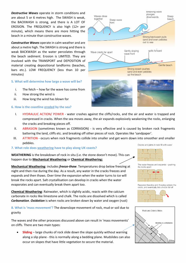
Destructive Waves operate in storm conditions and
are about 5 or 6 metres high. The SWASH is weak,
the BACKWASH is strong, and there is A LOT OF
EROSION. The FREQUENCY is also high (12+ per
minute), which means there are more hitting the
beach in a minute than constructive waves.
Constructive Waves operate in calm weather and are
about a metre high. The SWASH is strong and there is
weak BACKWASH as the water percolates through
the beach sediment. Erosion is LIMITED. They are
involved with the TRANSPORT and DEPOSITION of
material creating depositional landforms (beaches,
bars etc.). LOW FREQUENCY (less than 10 per
minutes)
5. What will determine how large a wave will be?
i. The fetch – how far the wave has come from
ii. How strong the wind is
iii. How long the wind has blown for
6. How is the coastline eroded by the sea?
I. HYDRAULIC ACTION/ POWER - water crashes against the cliffs/rocks, and the air and water is trapped and
compressed in cracks. When the sea moves away, the air expands explosively weakening the rocks, enlarging
the cracks and breaking pieces off.
II. ABRASION (sometimes known as CORRASION) - is very effective and is caused by broken rock fragments
battering the land, cliffs etc. and breaking off other pieces of rock. Operates like ‘sandpaper’.
III. ATTRITION - occurs when rock fragments collide into smaller and get worn down into smoother and smaller
pebbles.
7. What role does weathering have to play along UK coasts?
WEATHERING is the breakdown of rock in situ (i.e. the stone doesn’t move). This can
happen due to Mechanical Weathering or Chemical Weathering:
Mechanical Weathering: includes freeze-thaw. Temperatures drop below freezing at
night and then rise during the day. As a result, any water in the cracks freezes and
expands and then thaws. Over time the expansion when the water turns to ice will
break the rocks apart. Salt crystallisation can develop in cracks when the water
evaporates and can eventually break them apart too.
Chemical Weathering: Rainwater, which is slightly acidic, reacts with the calcium
carbonate in rocks like limestone and chalk. The rocks are dissolved which is called
Carbonation. Oxidation is when rocks are broken down by water and oxygen (rust)
8. What is ‘mass movement’? The downslope movement of rock, mud or soil due to
gravity
The waves and the other processes discussed above can result in ‘mass movements’
on cliffs. There are two main types:
Sliding – large chunks of rock slide down the slope quickly without warning
along a slip plane - this is normally along a bedding plane. Mudslides can also
occur on slopes that have little vegetation to secure the material.
Slumping – rainwater moves through the permeable sands
and gravels until it reaches the impermeable clay. The
water collects at this boundary and the weight of the
material above puts pressure on it. Eventually, the pressure
will cause a weakness to develop at the top of the cliff and
it tears away from the cliff face. The material
then slumps down along the curved slip plane
leaving material at the base of the slope.
Rockfalls – these occur when well-jointed
rocks (like limestone) are bare and left
exposed. Freeze-thaw weathering can result in
rocks becoming loose and they fall. The
materials can often create a scree slope at the
base of the cliff.
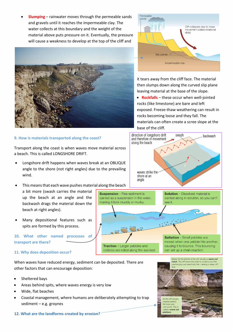
9. How is materials transported along the coast?
Transport along the coast is when waves move material across
a beach. This is called LONGSHORE DRIFT.
Longshore drift happens when waves break at an OBLIQUE
angle to the shore (not right angles) due to the prevailing
wind.
This means that each wave pushes material along the beach
a bit more (swash carries the material
up the beach at an angle and the
backwash drags the material down the
beach at right angles).
Many depositional features such as
spits are formed by this process.
10. What other named processes of
transport are there?
11. Why does deposition occur?
When waves have reduced energy, sediment can be deposited. There are
other factors that can encourage deposition:
Sheltered bays
Areas behind spits, where waves energy is very low
Wide, flat beaches
Coastal management, where humans are deliberately attempting to trap
sediment – e.g. groynes
12. What are the landforms created by erosion?

WAVE-CUT PLATFORM - Waves erode rocks along the shoreline by hydraulic action,
abrasion and corrosion. A notch is slowly formed at the high water mark which may
develop into a cave. Rock above the notch becomes unstable with nothing to support
it, and it collapses. The coastline (cliffs) can retreat over many years and a WAVE-
CUT PLATFORM forms as this process continues as only the base of the cliffs are left
as the cliffs recedes.
HEADLANDS AND BAYS - If there are alternate bands of hard and softer rock in the
coastline, the harder rocks take longer to erode than the softer rocks- because the
sea has less effect. The hard rock will be left jutting out forming one or more
HEADLANDS, usually with cliffs. The softer rock will be eroded to form BAYS, the
erosion means the bays will usually slope more gently inland, creating room for a
BEACH TO FORM. Can you work out where the hard and soft rocks are found on this
map of the coast at Swanage in Dorset?
CAVES, ARCHES AND STACKS
- A crack in a headland can be
eroded- wave energy is
usually strong there because
the headland juts out. This
forms one or more wave cut
notches/caves. Further
erosion enlarges the cave
and it breaks through the
headland forming an ARCH.
The roof of the arch is often
unstable and eventually
collapses leaving a STACK or
SERIES OF STACKS. Areas
with limestone or chalk
geology are prone to this
kind of erosion. MAKE SURE
YOU REFER TO ACTUAL NAMED PROCESSES HERE.
13. What are the landforms of deposition?
BEACHES – The table on the right shows the main differences
between pebble and sand beaches. Beaches can change
throughout the year too. Destructive waves in winter can
reduce the width of the beach and make it narrow/steep.
Material can be removed offshore to create a bar. In the
summer, constructive waves brings that material back
from the bar and makes the beach wider and
shallower.
SPITS - Deposition also creates SPITS (East Head Spit!!)
Spits are beaches joined to the coast at one end. At their seaward end shingle ridges form a series of recurves or hooks. Spits often develop across river mouths or where the direction of the coastline changes abruptly.
Pebble Beach Sandy beach
Shallow, flat, wide Tend to be steep, not very wide
Constructive Destructive
Can have sand dunes at their rear
Larger stones towards the back of the beach. Distinct ridges (berms)
An example you
could use is
Durdle Door in
Dorset for an
arch

Spits form by a process called LONGSHORE DRIFT (referred to earlier)
Tucked away behind spits are quiet backwaters that waves cannot reach, where tidal currents deposit fine silt and build up MUDFLATS and SALT MARSHES.
BARS - Deposition also creates BARS. Bars take spits one stage further
and actually extends further and join up to another headland. This is able
to happen due to the lack of a strong river current that would wash the
sediment away like in the tidal race of a spit. A good example of this is
Loe Bar in Cornwall or Slapton Sands in Devon (pictures right). These are
called BAY BARS. You can also get OFFSHORE BARS (submerged), which
run parallel to the coast.
SAND DUNES
Requirements for growth:
1. Frequent & strong onshore winds.
2. Wide foreshore exposed at low water so
that the sand can dry out and be
transported by the wind onshore.
3. Presence of a ‘trap’ for the blown sand
to encourage accumulation- this can be
drifted debris on the beach, shingle, tufts of grass etc.
How do they grow?
Vegetation can colonize. Marram grass, with its deep branching roots, stabilises the dune, but can only survive with
continued inputs of sand. As you move inland more (and varied) vegetation grows. You can see in the diagram above
the different names of the various dune ridges. As you move in land vegetation succession occurs, where decaying
vegetation inputs nutrients into the sand, which allows for a soil to develop (dunes are yellow near the start and appear
more grey as you move inland). This allows more luxuriant vegetation to grow until you see trees growing further
inland.
14. An example of a stretch of UK coastline to show its major landforms of erosion and deposition (continued on
next page)
Lulworth
Cove
Durdle
Door
Broad
Bench
Swanage
Bay
Old Harry
Rock
Studland
Sand Dunes
Hurst
Castle Spit
Bournemouth
Beach
Cliffs at Barton-
on-Sea
Purple = deposition landform
Red = Erosion landform
The pink boxed off area
will be used in the next
section

15. How can geological structure
influence coastal landforms?
This geology map right is the pink area
shown on the previous page.
It shows how geology can influence
coastal landforms. For example, along
the southern section of this coast the
rocks are CONCORDANT, which means
that they are aligned parallel to the
coast. On the eastern section of this
coast, the rocks are DISCORDANT,
which means that they are aligned at
90 degrees to the coast.
Lulworth Cove is formed along the concordant section
of the coast. The harder Portland and Purbeck
limestone acts as a barrier to the sea. Once penetrated,
the softer Wealden sand and clays + Greensand are
easily removed, until the more resistant chalk is
reached at the back of the cove.
Durdle Door has exactly the same rock types present, albeit in narrower bands. This is why there is in arch parallel to
the coast. The Wealden Clays and Greensand still remain to connect the promontory to the mainland.
At Swanage Bay (east of the map top right), the rocks are discordant. In this
instance, the harder chalk and limestone bands are more resistant to erosion and
consequently, have not eroded at the same rate of the bay (Wealden sand and
clays); this differential erosion has created headlands and bays.
Chalk
Wealden
sand/clays
Limestone
The ‘dip’ of the rocks also exerts and influence
on coastal landforms. The rocks have been
folded at Lulworth – you can see that they are
beyond vertical (see orange lines on the
picture). Consequently, the cliffs are near
vertical. If the dip was shallow, you would see
cliffs with a shallow gradient.
16. Who manages the coast? - DEFRA (Department for Environment, Food and Rural Affairs) is the government
department responsible for coastal defence. The Environment Agency and local councils decide on how best to spend
the money and protect the coastline.
17. How are coastlines actually protected?
Planners can use ‘hard’ strategies or ‘soft’ strategies.
Hard management: physical structures constructed to stop erosion by the waves – they tend to not blend in
well with their surroundings
Soft management: working with nature rather than against it. For example, beach nourishment – no physical
structures built and often blend in
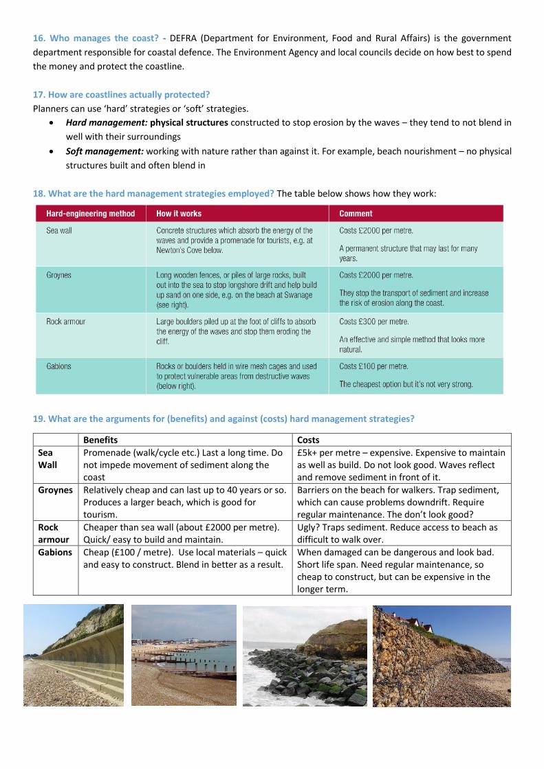
18. What are the hard management strategies employed? The table below shows how they work:
19. What are the arguments for (benefits) and against (costs) hard management strategies?
Benefits Costs
Sea Wall
Promenade (walk/cycle etc.) Last a long time. Do not impede movement of sediment along the coast
£5k+ per metre – expensive. Expensive to maintain as well as build. Do not look good. Waves reflect and remove sediment in front of it.
Groynes Relatively cheap and can last up to 40 years or so. Produces a larger beach, which is good for tourism.
Barriers on the beach for walkers. Trap sediment, which can cause problems downdrift. Require regular maintenance. The don’t look good?
Rock armour
Cheaper than sea wall (about £2000 per metre). Quick/ easy to build and maintain.
Ugly? Traps sediment. Reduce access to beach as difficult to walk over.
Gabions Cheap (£100 / metre). Use local materials – quick and easy to construct. Blend in better as a result.
When damaged can be dangerous and look bad. Short life span. Need regular maintenance, so cheap to construct, but can be expensive in the longer term.

20. What are the hard management strategies employed? Beach
nourishment/reprofiling and dune regeneration.
a). Beach nourishment – this where beach materials is brought in from elsewhere to
make the beach larger. The idea being that a larger beach will be able to dissipate wave
energy and protect the land. This has been done at Pevensey in East Sussex. Nourishment
can also take place if materials is simply RECYCLED. For
example, at East Head spit, materials has been taken from the
distal (far) end of the spit and was placed at the proximal
(where it connects to the mainland) end.
b). Beach reprofiling – when the material that is already
present on the beach as re-shaped to make the
beach higher. This means that waves can’t go over
the top and attack the land behind.
c). Sand dune regeneration – this is where existing
dunes are improved. For example, marram grass
can be planted to secure the dunes in place.
Ropes/fences can be used to prevent trampling.
Alternatively, it can be where new dunes are
created – sand can be brought in and then planted
with marram etc. The net effect being that the
dunes provide a barrier between the sea and the
land behind and prevent flooding.
21. What are the costs and benefits of these soft management strategies?
Benefits Costs
Beach nourishment Wider beach – protects properties. Better for tourism. Looks good.
Cheaper than hard management, but still expensive, especially as regular maintenance is required.
Beach reprofiling Beach higher, so land/property protected. Relatively easy to do.
£200,000 a year was spent at Selsey every year to perform this task – regular maintenance required.
Dune regeneration Produce natural looking dunes. Costs are low. Enhances ecosystems/ habitats
To ensure that people do not trample on the dunes, boardwalks, fences, roped areas, signs etc. all have to be provided – this is expensive. It may not work – a large storm could destroy all of your efforts. It takes time for the vegetation to establish/flourish
22. What is coastal realignment?
Coastal realignment is often referred to as ‘managed retreat’. It is when there is a new engineered position inland
from the current position of the coast. Essentially, it is where coastal managers decide that ‘holding the line’ is no
longer an option.
When it has been done, it has tended to be done in flat, low-lying areas of coast. People are moved out and buildings
demolished and a breach is made in existing sea defences. This allows the seas to flood in to produce new inter-tidal
habitats (salt marshes). A new embankment is made inland to prevent the water from going further inland.
It is done because sea levels are rising and it is believed that this is a better approach than constantly trying to shore
up sea defences – i.e. it is a sustainable approach.

23. An example of a coastal management scheme in the UK
At Medmerry, near Selsey in West Sussex, a large-scale coastal
management scheme has been undertaken – see red circle on the
map.
In Q22, managed retreat/coastal realignment was discussed. This
scheme is an example of exactly this. Therefore, the costs and
benefits discussed of this scheme apply to Q22 too.
Where?: Medmerry, near Selsey, West Sussex.
What?: example of coastal realignment (largest in Europe)
Why was it done?: The Environment Agency considered this area
as most at risk from flooding. As has been mentioned previously,
£200,000 was spent annually reprofiling the beach at
Selsey. In addition, this has not always worked – the last
breach occurred in 2008 and £5 million of damage was
caused. It was suggested that things would only get worse
(rising sea levels etc.), so a long-term solution was required.
What was actually done?: Completed in 2014.
Embankment built 2km inland (see white dotted line on
picture, right) using clay from the site itself to protect
properties further inland, but also to enclose the new inter-
tidal area. Sea defences breached to allow water in – this
100 metres entrance was protected by rock armour from
Norway (60,000 tonnes).
What have been the impacts of the scheme?:
Benefits/ Positives Costs/ Negatives
Economic Tourism expected to increase – birdwatchers, new car parks etc. Fishing nursery in the new salt marshes – boost local fishing industry
Economic £28 million! £200,000 per year to reprofile the shingle wall? Value? Loss of farmland – valuable agricultural land wasted
Social Selsey is now unlikely to be flooded, which was not the case before 10km footpaths, 7km bike paths, 5km new bridleways have all been created
Social Land simply given up – many locals don’t agree with this Huge cost – justifiable in such a sparsely populated area?
Environmental Species were protected before scheme was constructed 300 hectares of new inter-tidal habitat. Great for wildlife – huge RSPB nature reserve.
Environmental Loss of existing land –based habitats

Part 3: UK Glacial Landscapes in the UK 24. What does the term ‘Ice Age’ mean?
A period of time when ice sheets are found on continents. We
still have glaciers on land today, so strictly speaking we are still in
an Ice Age.
25. How long has the recent Ice Age lasted? - Scientists believe
that the climate has been similar for the last 2 million years or so.
This is called the Pleistocene Era. During that time, the glaciers
have advanced and retreated and in doing so has created many
impressive landscapes. In fact, Britain would have looked like
Greenland in the past. The maximum extent of the ice is shown on
the map on the right.
26. Are special names given for the periods for when glaciers
advance and retreat? - Yes. Warmer periods are called interglacial
periods and colder periods are called glacial periods. During the
most extreme glacial periods during the Pleistocene, Britain was almost completely covered by a huge ice sheet. The
map on the left shows this.
27. Glaciers move: how does this happen? (we don’t have any in the UK now, but important as this helps to explains
processes later on)
Glaciers move due to gravity. However
the rate of movement is due to the
GLACIAL BUDGET. This is the difference
between the accumulation and
ablation of ice each year. The diagram
(left) explains it:
Glaciers have an accumulation (adding
more) zone at the top, where it is
coldest. However, as the glacier moves
downhill the temperature increases and
the ice will melt. This is called ablation
(melting).
The balance of the accumulation and
the ablation will determine whether a
glacier moves forward (advance) or move backwards
(retreat) – i.e. as suggested by the glacial budget.
28. How does a glacier shape the land? - There are two main
erosion processes: Abrasion and Plucking.
Plucking is where a glacier moves over an area of rock.
Due to friction, the glacier melts and water seeps into
crack around the rocks below. The water refreezes and the rock effectively
becomes part of the glacier and is ripped out when the glacier continues to
move forward.
Abrasion is where rocks at the bottom of the glacier act like sandpaper –
grinding over the bedrock. This can polish the rocks or create sharp grooves
called striations.
29. What weathering process takes place?
The main process is freeze-thaw weathering (discussed earlier in coasts section).
The diagram on the right summarises this process – the key here is that
temperatures often oscillate around 0 degrees Celsius, which makes this process
prevalent. Water expands by about 10% when frozen, which forces the rocks
apart. You can see scree slopes in the UK where frost shattered materials has
accumulated at the base of the slopes. Much of this material may have been
formed during the ice age, but it is still an on-going process.
30. How do glaciers move/transport material?
Bulldozing is where rocks that are in front of the glacier are physically removed by the advancing glacier. Rocks that
have been subjected to freeze-thaw weathering may have fallen from slopes on to the glacier, which would have then
allowed for movement. Materials plucked at the base of the glacier is
then moved by it. Glaciers actually move due to gravity – the glaciers
move on a film of meltwater under the glacier – this is called basal
flow. If it is too cold and the film of water is not present, the glacier
can still move by oozing along by behaving like a plastic. This is called
internal deformation.
31. Why do glaciers deposit sediment?
Look back at Q27. You can see that glaciers flow from upland areas to
lowland areas. As the glacier moves downhill it becomes warmer and therefore the
glacier starts to melt. This meltwater can transport vast amounts of sediment. This is
called OUTWASH. This material is rounded and smoothed by the running water.
Eroded and weathered material dumped down by the glacier is called TILL. This differs
from outwash as the material is angular and not sorted by size.
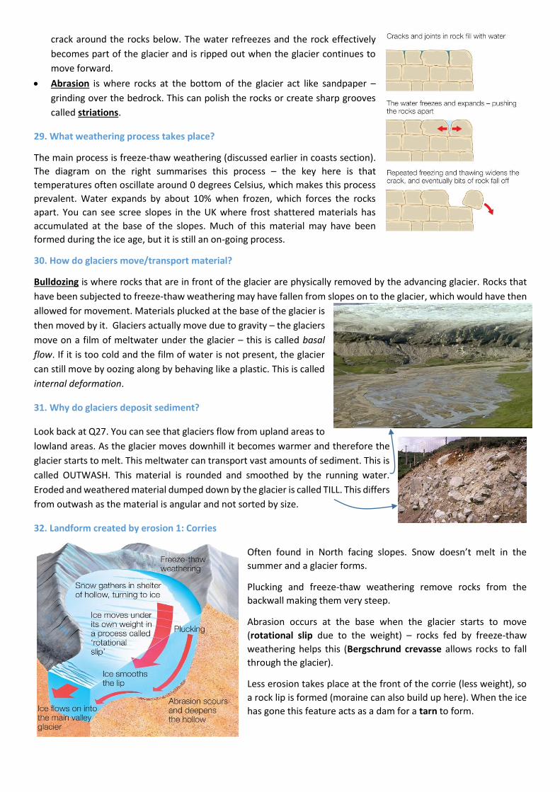
32. Landform created by erosion 1: Corries
Often found in North facing slopes. Snow doesn’t melt in the
summer and a glacier forms.
Plucking and freeze-thaw weathering remove rocks from the
backwall making them very steep.
Abrasion occurs at the base when the glacier starts to move
(rotational slip due to the weight) – rocks fed by freeze-thaw
weathering helps this (Bergschrund crevasse allows rocks to fall
through the glacier).
Less erosion takes place at the front of the corrie (less weight), so
a rock lip is formed (moraine can also build up here). When the ice
has gone this feature acts as a dam for a tarn to form.

33. Landform created by erosion 2: Arête - An arête is a sharp ridge cut when two corries either
side of a mountain cut back to back. The back/ side wall of each corries is attacked by freeze-
thaw weathering and plucking leaving a sharp ridge between them. The picture on the right is
Striding Edge in the Lake District.
34. Landform created by erosion 3: Pyramidal Peak
When you have three or more corries surrounding a mountainside, they cut back and produce
this feature. The diagrams below summarise arête and pyramidal peak formation.
35. Landforms created by erosion 4: Glacial
Trough, Truncated Spurs and Hanging Valleys
Glacial Trough: due to abrasion, plucking and bulldozing, the glacier will erode the landscape as it moves downhill.
Glaciers tend to occupy a former river valley and the erosion turns the V-shaped cross section into a U-shaped one.
The valley becomes wider, deeper and straighter as interlocking spurs are removed.
Truncated Spurs: River valleys have ‘Interlocking spurs’ like the teeth in a zip that overlap (see above left). However,
a glacier removes them and makes the valley straight.
Hanging Valleys: If you understand how a glacial trough is formed, then these are quite easy to understand. The main
glacier is the most powerful at eroding the landscape and cuts down quicker than the smaller valley glaciers that feed
into it. Therefore, once the ice has melted away, you are left with a main trough with small troughs feeding into the
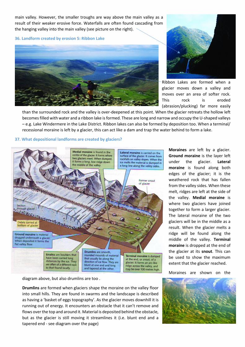
main valley. However, the smaller troughs are way above the main valley as a
result of their weaker erosive force. Waterfalls are often found cascading from
the hanging valley into the main valley (see picture on the right).
36. Landform created by erosion 5: Ribbon Lake
Ribbon Lakes are formed when a
glacier moves down a valley and
moves over an area of softer rock.
This rock is eroded
(abrasion/plucking) far more easily
than the surrounded rock and the valley is over-deepened at this point. When the glacier retreats the hollow left
becomes filled with water and a ribbon lake is formed. These are long and narrow and occupy the U-shaped valleys
– e.g. Lake Windermere in the Lake District. Ribbon lakes can also be formed by deposition too. When a terminal/
recessional moraine is left by a glacier, this can act like a dam and trap the water behind to form a lake.
37. What depositional landforms are created by glaciers?
Moraines are left by a glacier.
Ground moraine is the layer left
under the glacier. Lateral
moraine is found along both
edges of the glacier; it is the
weathered rock that has fallen
from the valley sides. When these
melt, ridges are left at the side of
the valley. Medial moraine is
where two glaciers have joined
together to form a larger glacier.
The lateral moraine of the two
glaciers will be in the middle as a
result. When the glacier melts a
ridge will be found along the
middle of the valley. Terminal
moraine is dropped at the end of
the glacier at its snout. This can
be used to show the maximum
extent that the glacier reached.
Moraines are shown on the
diagram above, but also drumlins are too .
Drumlins are formed when glaciers shape the moraine on the valley floor
into small hills. They are found in swarms and the landscape is described
as having a ‘basket of eggs topography’. As the glacier moves downhill it is
running out of energy. It encounters an obstacle that it can’t remove and
flows over the top and around it. Material is deposited behind the obstacle,
but as the glacier is still moving it streamlines it (i.e. blunt end and a
tapered end - see diagram over the page)
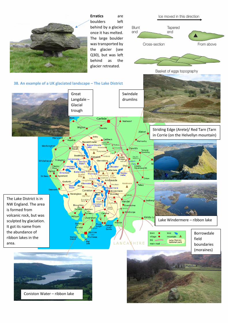
Erratics are
boulders left
behind by a glacier
once it has melted.
The large boulder
was transported by
the glacier (see
Q30), but was left
behind as the
glacier retreated.
38. An example of a UK glaciated landscape – The Lake District
Striding Edge (Arete)/ Red Tarn (Tarn
in Corrie (on the Helvellyn mountain)
Lake Windermere – ribbon lake
Coniston Water – ribbon lake
Great
Langdale –
Glacial
trough
Borrowdale
field
boundaries
(moraines)
Swindale
drumlins
The Lake District is in
NW England. The area
is formed from
volcanic rock, but was
sculpted by glaciation.
It got its name from
the abundance of
ribbon lakes in the
area.

39. What are the economic activities in glaciated regions?
These are split into 4 main categories:
1. Tourism – Scenery, walking, heritage etc. – see the places in the Lake
District!
2. Farming – Upland areas have thin soils, steep slopes, wet/windy
conditions. Consequently, hill sheep farming is suitable. In the
bottoms of the U shaped valleys the soils are thicker, so potatoes and
cereals can be grown. In lowland areas, the soils are fertile and are
suited to intensive arable farming.
3. Forestry – Conifer trees (Christmas trees) can be grown on the steep
slopes/ poor soils. The wood can be sold for the construction industry
and for paper.
4. Quarrying – Slate from the Lake District, limestone from the Pennines
etc.
40. How can conflicts between different land uses and between development and conservation occur? What sort of activities are done in glaciated regions that can cause
disagreement (conflict) between users?
Reservoirs – glacial troughs can be dammed, which is great for HEP and
water supply BUT you lose settlements and countryside
Wind turbines – Great for clean energy BUT not attractive? Deters
tourists?
Forestry – Conifer plantations can make money (see Q39) BUT can spoil
the view. Does not encourage biodiversity. Also, when cut down, can cause soil erosion and flooding.
Quarrying – makes money BUT visual appeal? Dust?
Tourism – makes money BUT congestion, higher house prices, litter, disturbs farm animals, water sports on lakes
noisy etc.
41. What can you do about resolving conflict in Q40? (we will pick
this up again in the Lake District example
Signs – tell visitors what they can and can’t do/ where they
can or can’t go
Visitor limits – restrict numbers
Show the benefit for locals – e.g. wind turbines in Kirkstone
Pass (Lake District), which provided power for the local pub
instead of using diesel generators
Fix footpaths
Park and Ride to ease congestion
Seasonal closure
42. An example of a UK glaciated area used for tourism: The Lake
District
a). Attractions for tourists (of which there are about 16.5 million a
year! – 50% of the income in the economy comes from tourism.
16,000 jobs exist because of tourism).
Glacial scenery – see Q38. Other ‘physical’ claims to fame: Largest lake in England – Windermere. Deepest lake in
England – Wastwater – 74 metres. Highest mountain in England – Scafell Pike 978 metres. Activities associated with
the landscape: walking, fell running, fishing, water sports etc.
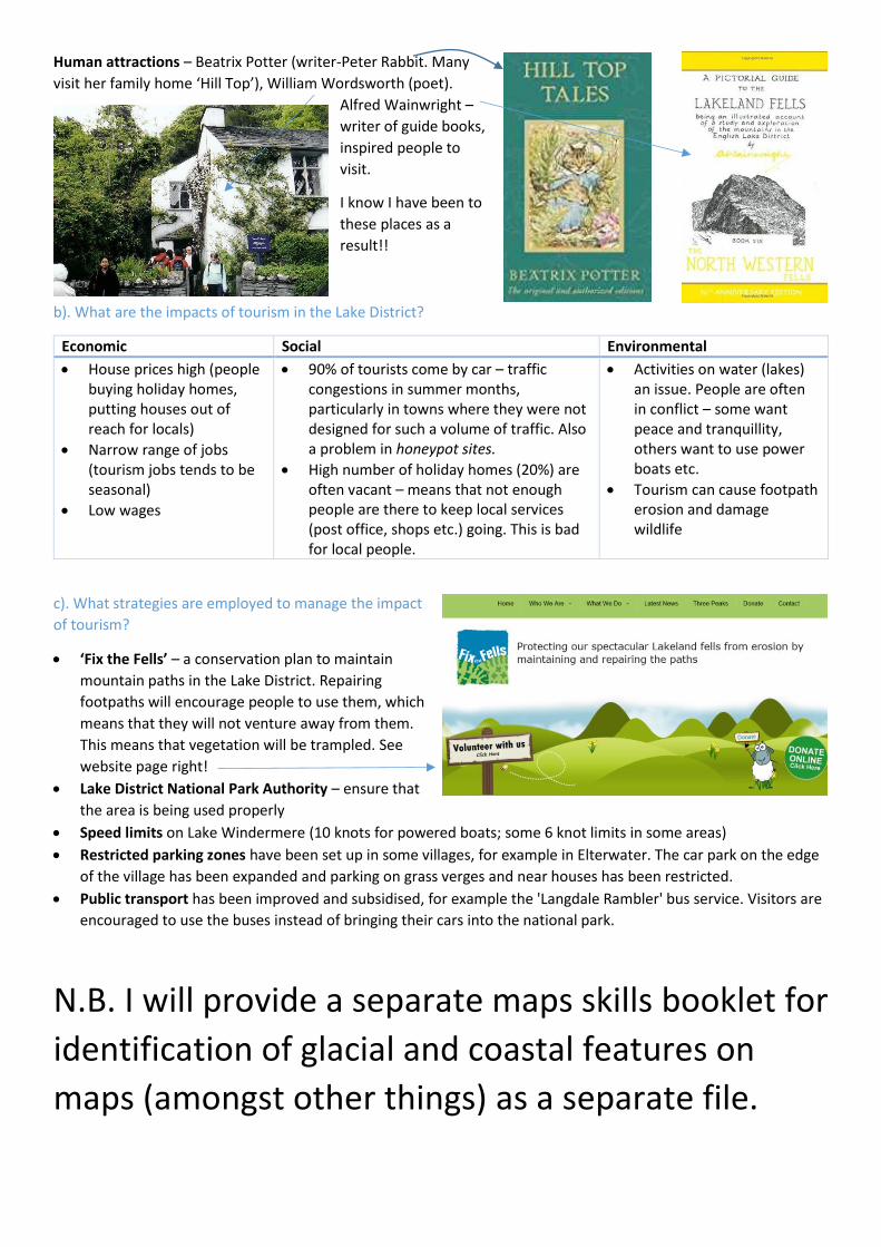
Human attractions – Beatrix Potter (writer-Peter Rabbit. Many
visit her family home ‘Hill Top’), William Wordsworth (poet).
Alfred Wainwright –
writer of guide books,
inspired people to
visit.
I know I have been to
these places as a
result!!
b). What are the impacts of tourism in the Lake District?
Economic Social Environmental
House prices high (people buying holiday homes, putting houses out of reach for locals)
Narrow range of jobs (tourism jobs tends to be seasonal)
Low wages
90% of tourists come by car – traffic congestions in summer months, particularly in towns where they were not designed for such a volume of traffic. Also a problem in honeypot sites.
High number of holiday homes (20%) are often vacant – means that not enough people are there to keep local services (post office, shops etc.) going. This is bad for local people.
Activities on water (lakes) an issue. People are often in conflict – some want peace and tranquillity, others want to use power boats etc.
Tourism can cause footpath erosion and damage wildlife
c). What strategies are employed to manage the impact
of tourism?
‘Fix the Fells’ – a conservation plan to maintain
mountain paths in the Lake District. Repairing
footpaths will encourage people to use them, which
means that they will not venture away from them.
This means that vegetation will be trampled. See
website page right!
Lake District National Park Authority – ensure that
the area is being used properly
Speed limits on Lake Windermere (10 knots for powered boats; some 6 knot limits in some areas)
Restricted parking zones have been set up in some villages, for example in Elterwater. The car park on the edge
of the village has been expanded and parking on grass verges and near houses has been restricted.
Public transport has been improved and subsidised, for example the 'Langdale Rambler' bus service. Visitors are
encouraged to use the buses instead of bringing their cars into the national park.
N.B. I will provide a separate maps skills booklet for
identification of glacial and coastal features on
maps (amongst other things) as a separate file.