part 1 – vision narrative introduction - us … albany... · · 2016-05-161 part 1 – vision...
TRANSCRIPT
NYS Capital Region Smart City Challenge 2016 Applicant: Capital District Transportation Committee
1
Part 1 – VISION NARRATIVE
Introduction The cities of Albany, Schenectady, Troy and Saratoga Springs, collectively, meet the size and demographic criterion for the Smart Cities Challenge and are proposing that as the NYS Capital Region Smart Cities team, they be considered as a Smart Cities Finalist candidate. The region’s major transportation corridors link these 4 cities, serve 4 counties, and impact 11 other jurisdictions. The transportation related issues that face these growing urban centers also impact the quality of life in these neighboring communities, and the region as a whole. A data driven, comprehensive Smart City vision that is shared, and the accompanying transportation based innovations that will be proposed as part of the planning process, will impact and benefit every city, town and village in the region. In addition, similar communities could benefit from the demonstration of successful regional strategies such as this across the nation. The Capital District Transportation Committee (CDTC) is the designated Metropolitan Planning Organization (MPO) for the Albany-Schenectady-Troy and Saratoga Springs metropolitan areas, and is acting as applicant. The New York State Department of Transportation (NYSDOT) is an active partner as well, and brings critical expertise and resources to the project. CDTC’s New Visions 2040: New Visions for a Quality Region plan (updated in 2015) includes recommendations that directly relate to challenges faced by the region, and in turn, the Smart Cities Challenge and the Capital Region Vision. Its planning and investment principles are:
• Investing in a Quality Region: A great transportation system with great choices will help make our region a Quality Region.
• Economic Development: Transportation is critical to our region’s economy. • Regional Equity: Transportation investments will address all needs fairly and equally. • Complete Streets: Street design will serve all users including pedestrians, bicyclists,
transit riders, freight, and drivers. • Bicycle and Pedestrian Transportation: Bicycle and pedestrian travel is vital to the
region’s public health, transportation, and the economy. • Transit: Transit services will provide modern, innovative, and viable travel options. • Infrastructure: Transportation funding must be sufficient to both repair and sometimes
replace our highway, bridge, and transit infrastructure. • Safety and Security: We can significantly save lives and reduce injuries when we
decrease traffic crashes and better respond to traffic emergencies. • Travel Reliability: Reliable traffic flow is more important than reducing congestion –
traffic congestion is often a sign of an area’s economic vitality. • Freight: Our freight system is crucial to the economy; it will be efficient and automated,
and will minimize its impact to communities. • Environment: Transportation choices should improve our environment, not harm it; and • Technology: We must plan for new, smarter, better, and rapidly changing
transportation technology. This final New Visions principle notes: “Advancements in technology, such as self-driving cars, self-adjusting traffic signals, smart phone apps, ridesharing, carsharing, and bikesharing will

NYS Capital Region Smart City Challenge 2016 Applicant: Capital District Transportation Committee
2
have tremendous and wide-reaching impacts on future transportation. These impacts include, but are not limited to, decreasing congestion, providing transportation to more seniors and people with disabilities, reducing traffic crashes, and more.” 1. The NYS Capital Region’s Smart Cities Vision The NYS Capital Region’s Smart Cities Vision includes the following:
• Connected and Automated Vehicles: Our Smart Cities will have connected and self-driving vehicles on our roads; which at critical mass (10 years or so out) benefits will be realized through less congestion and parking issues, fewer crashes, and more/better mobility for seniors and persons with disabilities. The foundation/infrastructure needed for these vehicles will be in place: better, more accurate, accessible everywhere GPS, internet signal and reliable cellphone coverage over the entire corridor. There would be stable, sophisticated connections between vehicles and the road (vehicle to infrastructure (V2I)), with sensors for weather, traffic, and actual road conditions (ice and snow). Smart buses will have more real-time scheduling information (to be included on the street light messaging), smart card and smart phone payment, and traffic signal priority (the ability to modify traffic signals which makes buses more efficient and effective).
• Smart Street Lights: Smart Street lights will have traffic sensors and some video
capability so that crashes and congestion can be detected instantaneously. These lights will provide variable messaging, emergency traffic routing, and weather, and in some instances video and audio capabilities for security reasons. Much further out in the future, virtual traffic signals, projected on the vehicle windshield will make physical traffic lights and their expensive accessory equipment such as poles, controller boxes obsolete. These lights would rely heavily on a computer controlling the intersection and the connection between the computer and the vehicle (vehicle to infrastructure (V2I)).
• Comprehensive Emergency Routing/GPS/Navigating systems: The region will have
an improved system that would include parking availability (on street, parking garages and lots) for both vehicles and trucks, including delivery, and self-driving tractor-trailer units waiting for their drivers at the interstate exit and waiting to enter their freight destination. The system would be able to distinguish the best routes for large trucks that are not allowed to park at their freight destination while waiting for to unload; avoiding the incidences of large trucks parking on a busy roadside. These systems will be more accurate and more responsive, with better sensors and software to make them available to everyone either by cellphone or via in-vehicle internet systems. This system will be available to the NYS DOT Traffic Management Center and to local law enforcement to enable them to react quickly to security or transportation system problems.
• State-of-the-Art Interactive Transportation Data Systems: The region will have
transportation data systems that are connected, interactive, and easily available to local governments, and the DOT Traffic Management Center. This will include new secure equipment (sensors), hardware and software platforms that make the data available and usable - public easily readable dashboards to all users.
NYS Capital Region Smart City Challenge 2016 Applicant: Capital District Transportation Committee
3
Challenges: Urban Migration Necessitates Evolved Regional Transportation Systems There has been a significant trend in the change in population in the Capital Region in the last few decades. Population changes in 1960-2010 show population growth in our suburban towns and population losses in the Cities of Albany, Schenectady, and Troy. It shows the “move to the suburbs” – a well-understood and documented trend nationwide. However, during 2000-2010 - for the first time in 50 years - our cities are growing, and people are moving back into them. Developers are building large-scale rental and condominium projects in the downtowns. Young professionals are moving into these units to be closer to their work places and closer to entertainment, and retired people are moving into these units to simplify their lives and to live near parks, trails, and entertainment, and in walkable communities. This trend is also indicated by examining growth in the U.S. Census “urban area boundaries” from the last two censuses in our area of upstate New York. There are 3 metropolitan areas - Albany-Schenectady-Troy, Saratoga Springs. In the maps below are the urban area boundaries for our area after the 2000 census (green highlighted area) and the 2010 census (yellow highlighted area). See Urbanized Area Maps, following the Annotated Preliminary Site Map for visual comparison. In 2000 the Capital District’s local urban areas (Albany-Schenectady-Troy, Saratoga Springs, and Glens Falls) were expanding out from their centers, but they were not connected. But in a relatively short period of time (only 10 years), in 2010 the urban areas are connected. Our urban areas are continuing to expand outward, but in 2010 they have bumped into each other. If you ignore the geographical boundary lines of the villages, cities, towns, and counties, you see ONE urban area stretching from the just north of Saratoga Springs (the Village of Lake George) to just outside of Albany (the Village of Ravena). Regional planners anticipate that in the next 10 years (by the next federal census) the areas between the Albany-Schenectady-Troy and the Glens Falls urban areas will continue to expand and fill-in. By 2020 our area will really be one metropolitan area with Interstate 87 and Interstate 90 running through its centers. In 2007 the Capital District Regional Planning Commission (CDRPC), conducted an in depth analysis of the demographic distributions and land use patterns to test the impacts of growth. Analysis outlined in the New Visions 2040 Plan shows that the actual growth from 2000 –2010 (43,674) is about 37% higher than the projected growth (31,838) for the same period. Instead of a projected growth of about 4%, the actual growth is about 5.5% over the 10-year period. If our population were able to continue to grow at this rate, it would certainly grow at a rate much higher (about 10%) than the 7% currently forecasted by CDRPC for 2010 – 2040. Using the CDRPC rate of about 7% growth in the next 30 years, applied to the latest 2010 census population results in a Capital District population increase between 2010 – 2040 58,658 and a population in 2040 of approximately 896,625 people. Using our region as a pilot also addresses the needs of both mid-sized (population greater than 200,000) and smaller cities. New York’s Capital Region as a Smart Cities Challenge Demonstration Site Using New York’s Capital Region as a proposed pilot deployment site for the Smart Cities challenge captures a diverse cross section of safety, mobility and environmental issues and needs, as well as opportunities for efficiency and service improvements by state and local transportation agencies. There are two main corridors that run through the Capital Region, the

NYS Capital Region Smart City Challenge 2016 Applicant: Capital District Transportation Committee
4
RT 5 Central corridor, and the I-87 corridor. These two corridors connect the 4 major cities and 11 other towns and villages in between. Located in the Northeastern region of New York State, the region’s 4 major cities are subject to large amounts of annual snow fall and long periods of transitional road conditions where temperatures go from above to below freezing. The harsh winter weather creates difficult driving conditions, generates significant damage to the roadways and puts a huge strain on state and local departments of transportation responsible for snow and ice removal. Along the RT 5 Central and I-87 corridors alone, NYSDOT spreads approximately 3,400 tons of salt per year at cost of over $200,000 annually. The NY Route 5 corridor links two of the larger “Upstate New York” cities, Albany and Schenectady. It is traversed by an average of 26,000 vehicles per day. The vehicles include 5% heavy vehicles and 22% trucks and buses indicating that this is an important route for commerce in the region. This corridor represents numerous urban safety, mobility and environmental issues facing many small to medium sized cities across the United States. These cities have central urban cores with high numbers of pedestrians that quickly transition into a suburban landscape that connects small cities to a large population of individual family homes that comprise a huge base of commuters. This particular corridor experiences a high number of annual accidents compared to other corridors. Over the past three years, the NY Route 5 corridor experienced an average of 700 total accidents per year with 14% leading to injury. The NY ROUTE 5: Comprehensive Pedestrian Safety Study published on November 12, 2014 and prepared for the NYSDOT, Cities of Albany and Schenectady, Towns of Niskayuna and Colonie and Village of Colonie (https://www.dot.ny.gov/regional-offices/region1/other-topics) detailed the pedestrian issues of the NY Route 5 corridor. The study found that there is a need for improvement of pedestrian safety all along the NY Route 5 corridor especially at the busiest pedestrian intersection at Lark Street in the City of Albany. NYSDOT, CDTA, and the City of Albany have been steadfastly working to implement solutions. Lack of fiscal resources has been a major limitation thus far – the Smart Cities funding would help to address this critical issue. In addition, the study found that the greatest number of pedestrian deaths occurred at the section of NY Route 5 corridor between the City limits of Albany and Schenectady. The Cities of Albany, Schenectady, Troy and Saratoga Springs are also home to a large number of citizens who choose public transportation for their travel needs. The busiest bus routes for Capital District Transportation Authority (CDTA), which provides public transportation services for four counties, operate between the Cities of Albany and Schenectady. Over 4.3 million passengers per year travel on CDTA busses along NY Route 5 corridor between Albany and Schenectady, with 70% using public transportation to reach their place of employment. CDTA has become a vital link to support the economic backbone of the region. The I-87 Corridor (“Adirondack Northway”) is a north-south corridor linking Albany with the City of Saratoga Springs to the north. This portion of the site is a two-and three-lane highway corridor (Functional Class 11). Elevation change is moderate rising from approximately 260 feet at State Route 20 to 350 feet south of the point of intersection with the Mohawk River, and descending to 300 feet at Exit 8 before rising to 350 feet at Exit 9. The Adirondack Northway also provides connectivity over the Mohawk River. This route can experience significant amounts of congestion, especially related to incidents, which can cause hours-long delays.

NYS Capital Region Smart City Challenge 2016 Applicant: Capital District Transportation Committee
5
I-87 is traversed by an average of 111,000 vehicles per day. These vehicles include 8% heavy vehicles and 27% trucks and buses, representing a higher percentage than the NY Route 5 corridor. Heavy vehicles and other commercial vehicles are heavy users of I-87, which connects Albany to Buffalo to the west, Boston to the east, Canada to the north and New York City to the south. CDTA also provides express commuter buses along this corridor. The I-87 corridor is subject to the greatest level of vehicle traffic in the region with the peaks occurring during morning and evening rush hour. Fortunately, the average number of accidents in the corridor is 370 or almost half the total number along NY Route 5 corridor. However, incidents along the I-87 corridor along with inclement weather can lead to long queues and major traffic delays generating a unique set of safety and mobility issues. Therefore, real time information and safe routing of vehicles is critical for overall well being of the region. An additional corridor included in this application is for technological improvements to the NY Route 4 & 32 corridor, which travels primarily along the Hudson River connecting Albany to Troy and other smaller urban communities. It includes multiple downtowns, village centers, and urban neighborhoods that are experiencing revitalization with new residents, retails/restaurants, and businesses choosing to relocate in these areas while renovating historic structures for adaptive reuse. This corridor has a significant volume of vehicular traffic with segments over 20,000 AADT. The corridor is served by multiple CDTA bus routes which combined consist over 2.3 million rides per year. Finally, environmental issues of increased emissions and fuel consumption impact the NY Route 5 and I-87 corridor because of their high use and proximity to the greatest concentration of population in the region. Relevant Proposed Project Elements The key proposed Smart Cities Challenge project elements that can be used to address the challenge described above, and are expected to have the most impact include: the use of Intelligent, Sensor-Based Infrastructure and Intelligent Transportation Systems (ITS), User-Focused Mobility Services based on Complete Streets and Transit Oriented design, Connected Vehicles and Electric Fleet Vehicles, and Connected, Involved Citizens who will utilize our improved transportation systems to foster the shared economy. Individual Vision Elements and corresponding technology solutions being proposed are detailed later in this proposal. Approach for Implementation and Program Management
The Team utilizes its proven systems engineering and project management processes to perform ITS projects. It uses defined and approved processes and standards for project management, development of project management plans, schedule development, cost tracking, and configuration management. If an issue develops that was not anticipated or planned for properly, the Team can quickly mobilize its considerable resources to adapt to the challenges presented. If chosen as a Finalist, the NYS Team will be formally organized with existing contracts and/or contract protocols in place for sub-consultants. The various levels of Task, Phase and Program Leaders will provide constant review and resolution. Commonly used management and scheduling tools are used to assist with schedule requirements.
NYS Capital Region Smart City Challenge 2016 Applicant: Capital District Transportation Committee
6
The NYS Capital Region Smart Cities team acknowledges that there are a number of issues involved and challenges that can potentially arise as part of managing a multi-faceted pilot deployment project such as this. These include, but are not limited to:
• Maintaining clear and effective communication among all parties involved: federal, state, local entities, universities, and private sector team members
• Coordination with other programs • Managing the scope of a project that is deploying exciting, new
technology that has the potential to transform the transportation system
• Effective risk management among a diverse set of team members/partners/stakeholders
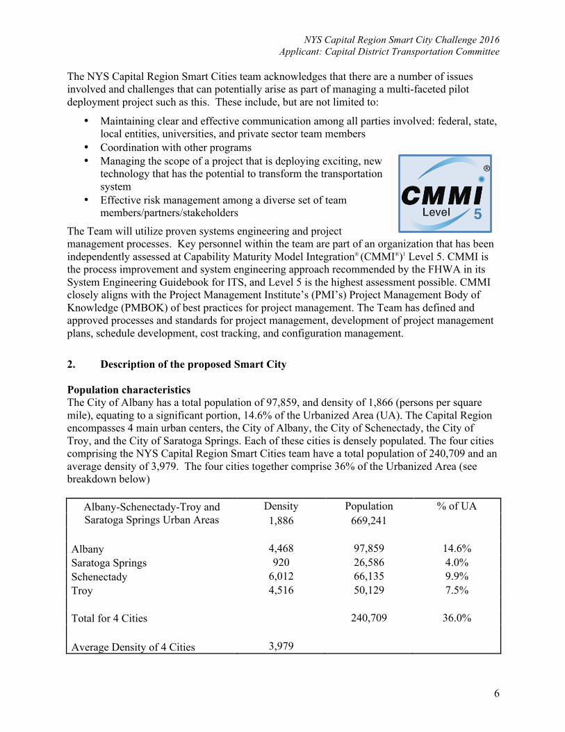
The Team will utilize proven systems engineering and project management processes. Key personnel within the team are part of an organization that has been independently assessed at Capability Maturity Model Integration® (CMMI®)1 Level 5. CMMI is the process improvement and system engineering approach recommended by the FHWA in its System Engineering Guidebook for ITS, and Level 5 is the highest assessment possible. CMMI closely aligns with the Project Management Institute’s (PMI’s) Project Management Body of Knowledge (PMBOK) of best practices for project management. The Team has defined and approved processes and standards for project management, development of project management plans, schedule development, cost tracking, and configuration management. 2. Description of the proposed Smart City Population characteristics The City of Albany has a total population of 97,859, and density of 1,866 (persons per square mile), equating to a significant portion, 14.6% of the Urbanized Area (UA). The Capital Region encompasses 4 main urban centers, the City of Albany, the City of Schenectady, the City of Troy, and the City of Saratoga Springs. Each of these cities is densely populated. The four cities comprising the NYS Capital Region Smart Cities team have a total population of 240,709 and an average density of 3,979. The four cities together comprise 36% of the Urbanized Area (see breakdown below)
Albany-Schenectady-Troy and Saratoga Springs Urban Areas
Density Population % of UA 1,886 669,241
Albany 4,468 97,859 14.6% Saratoga Springs 920 26,586 4.0% Schenectady 6,012 66,135 9.9% Troy 4,516 50,129 7.5% Total for 4 Cities 240,709 36.0%
Average Density of 4 Cities 3,979

NYS Capital Region Smart City Challenge 2016 Applicant: Capital District Transportation Committee
7
3. Other Characteristics Aligning with USDOT characteristics of a Smart City Existing public transportation system The Capital District Transportation Authority (CDTA), created by the state legislature in 1970, is the Capital Region’s mobility company with an annual ridership of 17 million. A nine-member Board of Directors directs CDTA activities, representing the four counties that comprise the service district. CDTA operates 270 buses from three facilities in Albany, Schenectady, and Troy. CDTA also owns and operates the rail stations in Saratoga Springs and Rensselaer. We serve a metropolitan area of 800,000 people and have a workforce of 630.
• Albany County spans 523 square miles. 90% of the population is urban; 10% is rural. • Rensselaer County spans 654 square miles. 69% of the population is urban; 31% is rural. • Saratoga County spans 812 square miles.70% of the population is urban; 30% is rural. • Schenectady County spans 206 square miles. 92% of the population is urban; 8% is rural.
CDTA provides express, park & ride, local, suburban shuttle, and paratransit services. The paratransit service, “STAR”, is a door-to-door advance reservation system for people with disabilities. The Authority owns 300 transit vehicles and employs 650 people – more than 550 of whom are members of the Amalgamated Transit Union. CDTA is committed to providing the best transit service possible by being responsive to the needs of the community it serves. Over the years the Authority’s Mission Statement has evolved and been shaped to focus clearly on the customer: “To Transport Customers Safely and Reliably at a Reasonable Cost”. CDTA serves about 55,000 customers on a typical weekday. Buses travel 24,000 miles each day along 50 individual routes. Fixed communications infrastructure exists at four locations throughout the four county Capital Region of New York State. CDTA views Mobility Management and the provision of transportation alternatives, such as ridesharing services, to be critical to its mission. Commitment to Project and Smart Cities Principles The proposed NYS Capital Region Smart Cities Challenge team is operating in an environment of unprecedented inter-agency and inter-municipal cooperation. The Capital Region, part of New York State’s “Tech Valley” is embracing and pursuing the technological advances that will enable businesses and individuals to thrive in the new age of cyber-mobility and the shared economy. The Smart Cities endeavor is supported with CDTC’s 50-year history of regional cooperation regarding transportation planning and programming, dynamic and engaged members, and relevant, active committees such as Regional Operations and Safety Advisory Committee, our Bicycle/Pedestrian Advisory Committee, and our Freight Advisory Committee. Comprised of the primary transportation routes in the Capital Region, the Smart Cities geographic area contains a variety of key, multi-modal transportation system elements and features. These features will allow for aggressive and varying types of technological solutions to be explored. One of the main objectives of this collaboration is to make pilot discoveries and experiences open to others. This will serve to feed the growing shared economy, and support the current atmosphere of entrepreneurship and innovation, through open, accessible machine-readable resources.
4. Annotated Preliminary Site Map – SEE NEXT PAGE.
NYS Capital Region Smart City Challenge 2016 Applicant: Capital District Transportation Committee
8

NYS Capital Region Smart City Challenge 2016 Applicant: Capital District Transportation Committee
9
Saratoga Springs
Schenectady
Cohoes
TroyWatervliet
Mechanicville
Albany
Rensselaer
Hoosick
Falls
Schaghticoke
Valley Falls
East
Nassau
Nassau
Castleton-on
-Hudson
Ravena
Voorheesville
Menands
Waterford
ColonieAltamont
Delanson
Scotia
Round
Lake Stillwater
Galway
Ballston
Spa
South
Glens
Falls
Corinth
Schuylerville
Victory
Glens
Falls
Whitehall
Lake
George
Hudson
Falls
Fort
Edward
Argyle
Granville
Salem
Cambridge
Greenwich
Day
Berne
Berlin
Corinth
Hoosick
Knox
Colonie
Edinburg
Pittstown
Westerlo
Schodack
Greenfield
Nassau
Duanesburg
Grafton
Galway
Hadley
Moreau
Glenville
Malta
Wilton
Milton
Coeymans
Guilderland
Saratoga
Bethlehem
Stillwater
Stephentown
New Scotland
Brunswick
Clifton Park
Rensselaerville
Providence
Schaghticoke
CharltonBallston
Petersburgh
Rotterdam
Sand Lake
Halfmoon
Poestenkill
East Greenbush
Princetown
Northumberland
Niskayuna
North
Greenbush
Waterford
Green
Island
Fort Ann
Argyle
Easton
Salem
Hebron
Dresden
Whitehall
Granville
Hartford
Jackson
Putnam
Greenwich
Kingsbury
White CreekCambridge
Hampton
Fort
Edward
Johnsburg
Bolton
Hague
Chester
Thurman
Horicon
Stony Creek
Queensbury
Warrensburg
Lake
Luzerne
Lake
George
µ
April 2014
2000 Capital District Adjusted Urbanized Area Boundaries
5 0 5 10 15 20Miles
Data Sources: NYSDOT, FHWA, US CENSUSBUREAU, CDTC, AGFTC
Legend
2000 Small Urbanized Areas
2000 Capital DistrictAdjusted Urbanized Area
Mechanicville
Ravena
Villages
Cities
TownsCounty Lines
Saratoga Springs
Schenectady
Cohoes
TroyWatervliet
Mechanicville
Albany
Rensselaer
Hoosick
Falls
Schaghticoke
Valley Falls
East
Nassau
Nassau
Castleton-on
-Hudson
Ravena
Voorheesville
Menands
Waterford
ColonieAltamont
Delanson
Scotia
Round
Lake Stillwater
Galway
Ballston
Spa
South
Glens
Falls
Corinth
Schuylerville
Victory
Glens
Falls
Whitehall
Lake
George
Hudson
Falls
Fort
Edward
Argyle
Granville
Salem
Cambridge
Greenwich
Day
Berne
Berlin
Corinth
Hoosick
Knox
Colonie
Edinburg
Pittstown
Westerlo
Schodack
Greenfield
Nassau
Duanesburg
Grafton
Galway
Hadley
Moreau
Glenville
Malta
Wilton
Milton
Coeymans
Guilderland
Saratoga
Bethlehem
Stillwater
Stephentown
New Scotland
Brunswick
Clifton Park
Rensselaerville
Providence
Schaghticoke
CharltonBallston
Petersburgh
Rotterdam
Sand Lake
Halfmoon
Poestenkill
East Greenbush
Princetown
Northumberland
Niskayuna
North
Greenbush
Waterford
Green
Island
Fort Ann
Argyle
Easton
Salem
Hebron
Dresden
Whitehall
Granville
Hartford
Jackson
Putnam
Greenwich
Kingsbury
White CreekCambridge
Hampton
Fort
Edward
Johnsburg
Bolton
Hague
Chester
Thurman
Horicon
Stony Creek
Queensbury
Warrensburg
Lake
Luzerne
Lake
George
µ
April 2014
2010 Capital District Adjusted Urbanized Area Boundaries
5 0 5 10 15 20Miles
The Glens Falls Urbanized Area is not yet finalizedData Sources: NYSDOT, FHWA, US CENSUS
BUREAU, CDTC, AGFTC
Legend
2010 Small Urban Clusters
2010 Capital DistrictAdjusted Urbanized Area
Corinth, NY Urban ClusterGranville, NY--VT Urban ClusterGreenwich, NY Urban ClusterHoosick Falls, NY Urban ClusterRavena, NY Urban ClusterWarrensburg, NY Urban Cluster
Villages
Cities
TownsCounty Lines
NYS Capital Region Smart City Challenge 2016 Applicant: Capital District Transportation Committee
10
5. Integration of USDOT Vision Elements and Technology Solutions The Capital Region Team will use an integrated approach to its Smart Cities Challenge demonstration project, aligned to the prescribed 12 USDOT Vision Elements. Many of the Vision Elements support each other, and/or are intertwined - when implemented together, these elements maximize cost savings and efficiency. Combining these elements will create a measurable impact on the region’ s transportation system and the quality of life in the region.
Vision Element # 1 Urban Automation Approach & Proposed Technology Solutions The Capital District Smart Cities Challenge team will build a framework for more sophisticated Urban Automation though its pursuit of the Connected Vehicle deployment. Demonstrations by Google of a totally automated vehicle have made the full development of this technology plausible, however the timeline is uncertain. Our team will follow the progress while focusing on the incremental approach appropriate to our scope. Currently CTDA is pursuing the upgrade of our Computer Aided Dispatch/Automatic Vehicle Location (CAD/AVL) system and related Advanced Public Transportation Systems (APTS) technologies, with current Intelligent Transportation Systems (ITS). The goal of this project is to improve transit service safety, reliability, and efficiency. This project is also integrated with a larger effort to achieve 40 miles of Bus Rapid Transit (BRT) service in the New York State Capital Region. One of the key elements of BRT that makes this type of service attractive and efficient is the use of advanced vehicle technology. In addition to providing basic reliable communications, using hybrid electric technology and alternative fuels, with various amenities such as automatic announcements, real time passenger information, and safety triggers, onboard systems can be integrated with maintenance systems to provide for automated maintenance notifications and alerts. This functionality is an integral part of a newly implemented preventive maintenance program designed to lower the number of unscheduled repairs, extend each vehicle’s useful life, enhance the safety of our customers and employees, and lower overall operating costs. An ITS concept of operations and a system design specification have been completed to enable a quick turnaround from a Request For Proposals (RFP) to implementation. Moreover, an already existing operations plan will enable the system verification and validation stages of the project to take place more quickly upon completion of the software/hardware development and implementation phases. This project will accommodate approximately 300 revenue vehicles (fixed route and paratransit), approximately 50 non-revenue vehicles and support equipment, and mobile data communications infrastructure at four locations. Vision Element #2: Connected Vehicles Approach & Proposed Technology Solutions As part of the NYS Capital Region Smart Cities Challenge Team, The New York State Department of Transportation (NYSDOT) in partnership with the University Transportation
NYS Capital Region Smart City Challenge 2016 Applicant: Capital District Transportation Committee
11
Research Center Region 2 (UTRC) is proposing deployment of connected vehicle technology along two connected “Smart” corridors in the Capital Region of New York State. The proposal includes: public and private fleets; smart phone, satellite, and 5.9 DSRC communications; installation of 22 RSUs; instrumentation of approximately 100 plow trucks and maintenance vehicles and 50 busses; and installation of pedestrian detection and warning systems at two intersections. The deployment of CV technology across the pilot site will deliver the following core functionality to improve safety, mobility, environment and agency efficiency for the region’s main RT 5 Central Av and I-87 corridors: Safety:
• Pedestrian in signalized crosswalk warning (RT 5, RT 4/32) • Collecting and transmitting pavement and roadway condition data on smoothness,
potholes and debris (RT 5, RT 4/32 and I-87) – Special Research Area** • Providing work zone alerts (RT 5, RT 4/32 and I-87) • Forward collision warning (RT 5. RT 4/32 and I-87) • Red light violation warning (RT 5, RT 4/32 and Central Ave) • Emergency electronic brake lights (RT 5, RT 4/32 and I-87) • In-vehicle signage (RT 5, RT 4/32 and I-87) • Curve speed warning (I-87) • Queue warning (RT 5, RT 4/32 and I-87) • Support collection and transmission of other vehicle data (RT 5, RT 4/32 and I-87):
o --Basic safety message o --Real time traveler information o --Real time routing information o --Road weather information o --Vehicle telematics (health, status, position)
• Heavy Vehicle off route/pending bridge collision safe vehicle shut down (general application capabilities include 3 levels of sophistication for informing drivers of hazards such as stop sign, grade crossing and pending bridge collision, Driver Alert - 1, Driver Warning - 2, and System Intervention – 3) – Special Research Area**
Mobility: • Eco-traffic signal priority (RT 5, RT 4/32 and Central Ave) • Self organized traffic management (RT 5. RT 4/32 and Central Ave) • Queue warning (RT 5, RT 4/32 and I-87) • Real time traveler information (RT 5, RT 4/32 and I-87) • Real time routing information (RT 5, RT 4/32 and I-87) • Road weather information data on visibility, temperature, road conditions, and treatment
recommendation (RT 5 and I-87) Environment:
• Eco-traffic signal priority (RT 5, RT 4/32 and Central Ave) • Self organized traffic management (RT 5, RT 4/32 and Central Ave) • Air monitoring at traffic signal intersections (RT 5, RT 4/32 and Central Ave)

NYS Capital Region Smart City Challenge 2016 Applicant: Capital District Transportation Committee
12
• Vehicle telematics (health, status, position) (RT 5, RT 4/32 and I-87) • Road weather information (RT 5, RT 4/32 and I-87)
Agency Efficiency: • Vehicle telematics (health, status, position) (RT 5, RT 4/32 and I-87) • Road weather information data on visibility, temperature, road conditions, and treatment
recommendation (RT 5, RT 4/32 and I-87) • Collecting and transmitting pavement and roadway condition data on smoothness,
potholes and debris (RT 5, RT 4/32 and I-87) Vision Element #3: Intelligent, Sensor-Based Infrastructure. Approach & Proposed Technology Solutions
As explained in Element Vision #2, intelligent, sensor-based infrastructure necessary to achieve success with the proposed Connected Vehicles portion of the Smart Cities vision. Traffic Signal Technology innovations have already been employed to a limited extent locally. The Team proposes regional pilot rollouts for these tools to the extent possible, as well:
• Signal coordination providing the opportunity for cars to move along an arterial with only infrequent stops at traffic signals, and significantly reduce delay. • Transit Signal Priority (TSP) is an innovation that allows buses to activate signals for extended green time as they approach a signal if they are behind schedule. The extended green time is usually ten seconds, which allows transit vehicles to provide higher quality service. It should be noted that autos in the same traffic stream with the bus would benefit as well. Because the green phase is typically extended only two or three times per hour, the impact on side streets is minimal. CDTC supports TSP as an important tool for improving transit service. TSP has been implemented in the Route 5 BusPlus corridor and is being developed for other corridors. Queue jumper signal phases also have the potential to improve transit on time performance by allowing buses to advance on green ahead of other vehicles, without disrupting traffic flow. • Pedestrian Signals Innovation include pedestrian activation of advanced walk phases, where pedestrians can begin crossing before vehicles enter the intersection; exclusive pedestrian phasing, where all vehicles, including right-turn-on red movements, are stopped while the pedestrian crosses. Countdown timers for pedestrians make crossing easier. In addition, a new type of signal for midblock pedestrian crossing has been introduced, called a HAWK beacon. This signal requires autos to stop only when a pedestrian needs to cross. Innovative technology holds promise for improving midblock pedestrian crossings, school crossings, and speed control. • Adaptive signal control is where the signal controller makes adjustments to cycle length, off-sets and phase timings in real-time based on changes in the traffic characteristics on the arterial. This can be especially valuable during an incident on an expressway, when traffic may divert to a parallel arterial. Adaptive signal control has been recommended for the Northway/Route 9 corridor in the I-87/US 9 Integrated Corridor Management Plan. Under adaptive control, traffic signals in a network communicate with each other and adapt to changing traffic conditions to reduce the amount of time cars and trucks spend idling. Using fiber optic video receivers similar
NYS Capital Region Smart City Challenge 2016 Applicant: Capital District Transportation Committee
13
to those used in dynamic control systems, the new technology monitors vehicle numbers and makes changes in real time to minimize congestion wherever possible. • Self-Organizing Signals is an example of an Adaptive Signal Control system being developed and tested at the University at Albany This proposed system is based on the theory of self-organizing traffic signals. Analogous to biological systems, each traffic signal in the system would communicate with the immediately adjacent signals and based on traffic sensor information would adjust the signal timing plan. This innovative approach has the potential to respond to minor changes in traffic flow as well as major changes to traffic flow in a way that optimizes the system. CDTC will continue to monitor its development. Vision Element #4: Urban Analytics Approach & Proposed Technology Solutions Travel patterns in the Capital Region are continually changing as our cities revitalize and where people choose to live, work, and play is transformed. Advanced technologies will give the region a better understanding of individuals’ origins and destinations to allow us to align transportation services and in particular provide faster and more direct connections via public transit. CDTA currently has the ability to track boardings & alightings by stop with interfacing a combination of technologies – including each bus’s GPS system and automatic passenger counters (APC) which are triggered by riders passing through a series of infrared beams in the doorway. This technology is useful, but limited, as it cannot match where a rider boards and where they alight. It is also limited as it only captures existing transit riders and not those already in their automobiles. The vision for the Capital Region Smart Cities is to collect data at a mass scale that matches the origins & destinations of as many travelers as possible using as many modes of transportation as possible, so that this information can be used by a variety of entities for transportation planning and CDTA in particular for adjustments to its route network. For example this data could show the number of individuals working in walking distance of bus stops in Downtown Troy who also live off of Interstate 87 and pass CDTA park & rides on their commute. The number of these drivers and the times they travel would be all the information CDTA needs to justify expansion of its Northway Xpress service to Downtown Troy. One example of an application of this element: CDTA’s automatic passenger counters and GPS bus tracking currently does not exist on the Northway Xpress (NX) and thus no boarding/alighting information can be provided along Interstate 87. The first year of funding from Smart Cities would be used to properly equip the NX commute coaches with all of the technologies on the rest of CDTA’s fleet. Vision Element #5: User-Focused Mobility Services and Choices. Approach & Proposed Technology Solutions Vehicle miles of travel are highly correlated with greenhouse gas emissions, and projects that reduce vehicle miles of travel are generally more effective in reducing greenhouse gas emissions. TDM reduces congestion, reduces the costs of driving, and is an important way to reduce greenhouse gas emissions. CDTC strongly supports Travel Demand Management (TDM) by
NYS Capital Region Smart City Challenge 2016 Applicant: Capital District Transportation Committee
14
investing in transit, bicycle and pedestrian facilities, ridesharing and land use planning. CDTA sponsored programs that could be expanded or enhanced under the Smart Cities Vision include: • Transit pass subsidies (i.e.) Homeowner Incentive and Refugees & Immigrants programs. • www.capitalmoves.org., the travel options website for the Capital Region • Capital CarShare in Albany. Potential expansion: Troy, Schenectady and Saratoga Springs. • CDTC sponsored four demonstration/trial weeks of Bike Share during the summer (2014) in Albany, Schenectady, Troy and Saratoga Springs, and is eager to expand the program. • Park and Ride lots for transit and carpool use and partnerships with vRide for vanpools. Emerging technology enabled (often smart phone) ride hailing services could have future roles in reducing the need for owning/using a personal vehicle for certain trips. These options have the potential to compete with transit as well as support it by offering an additional way to connect to transit, a service that is currently only provided by taxis in the Capital Region. In addition, CDTA’s upgrade the fare collection system for smart cards and mobile phone ticketing, replace the Computer-Aided Dispatch and Automated Vehicle Location systems, and expand Transit Signal Priority and real-time arrival information from BusPlus to local services exemplify the regional commitment to embracing technology solutions Vision Element #6: Urban Delivery and Logistics Approach & Proposed Technology Solutions The Team is not proposing any additional projects aimed specifically at urban delivery and logistics. However, the technologies and approaches contained in many of the other elements will provide beneficial to the commercial sector as well as the individual. Connected vehicles and sensor driven infrastructure can improve road safety, save time and increase efficiency. Vision Element #7: Strategic Business Models and Partnering Opportunities Approach & Proposed Technology Solutions The Capital Region Smart Cities Team is committed seeking out collaborative opportunities that will further the Smart Cities Vision. In the case of the Connected Vehicle element of the proposed project, as mentioned previously, NYSDOT is partnering with University Transportation Research Center Region 2 (UTRC). In fact, the CV Element Team is comprised of nine NYSDOT transportation professionals that each has an average of over twenty years of experience and twenty-four leading experts in connected vehicle technology from academia, nonprofits and the private sector of which nine possess PhDs.
The partnerships developed through universal access agreements with numerous universities, private businesses and others in the Capital Region has been an enormous success with ridership increasing each year with each new partner added. CDTA intends to further expand the Universal Access program. These partnerships allow employees/students free transit access using their institutions’ ID card or other means.
NYS Capital Region Smart City Challenge 2016 Applicant: Capital District Transportation Committee
15
Vision Element #8: Smart Grid, Roadway Electrification, and Electric Vehicles Approach & Proposed Technology Solutions Under the Smart Cities initiative, electric vehicles are proposed as part of the Washington-Western Bus Rapid Transit - Purple Line project, which is described in detail in Vision# 9. Dedicated funding would be used to pilot and operationalize approximately 15 electric buses. This Smart Cities element would include the necessary infrastructure at the BRT Termini and the Albany Maintenance Garage. Vision Element #9: Connected, Involved Citizens. Transportation services Approach & Proposed Technology Solutions Bus Rapid Transit (BRT) is a high performance transit service that functions more like light rail than a local bus. BRT systems typically incorporate elements such as limited stops, priority treatment at traffic signals, bus lanes to bypass traffic at key congested locations, an identifiable brand name and color scheme and station amenities such as real time arrival/departure information, attractive shelters, park-and-ride lots, benches and in some cases restrooms and other services. Local buses, sometimes referred to as feeders, to bring passengers to the high performance BRT routes, complement BRT systems. CDTA has implemented BRT in mixed traffic on NYS Route 5 from downtown Albany to downtown Schenectady, known as BusPlus. To further encourage transit use, Transit Oriented Development (TOD) is encouraged at BRT or other transit service stations. Transit Oriented Development is generally defined as mixed-use development (development that mixes residential, retail, office, open space, and public uses) within walking distance of a transit stop that encourages travel on foot or by public transportation instead of by car. Since the New Visions plan was first adopted and following the numerous studies that were undertaken thereafter, a great deal has been accomplished in improving the regional transit system. All of these accomplishments have built a strong foundation for the region’s Smart Cities Challenge Vision. Route 5 BRT: The region’s first arterial based bus rapid transit system (arterial bus rapid transit) was officially opened in April 2011 following several years of study and incremental implementation of the system. Operating in mixed traffic, the Route 5 BRT (the first CDTA branded BusPlus route) runs from downtown Albany to downtown Schenectady. In its first year of operation, ridership increased 25%, on time performance was greatly improved, and the look and feel of transit in the Capital Region vastly changed. In order to improve the attractiveness and reliability of the system, CDTA worked with a number of regional partners to install limited stop service, unique branding to differentiate BusPlus from the rest of CDTA’s system, large stations with shelters and other customer information and conveniences, queue jumpers at certain signals which allow the BusPlus vehicle to move ahead of the rest of traffic by allowing a few seconds for the bus to move ahead of the rest of traffic at a signal, and transit signal priority was installed to allow the buses to communicate with traffic signals to provide priority to the buses when traveling through these intersections. Washington/Western BRT: CDTA completed a conceptual design study and detailed Alternatives Analysis of a second BRT line in the Capital Region (the BusPlus Purple Line), proposed to operate from downtown Albany through the Harriman and University at Albany

NYS Capital Region Smart City Challenge 2016 Applicant: Capital District Transportation Committee
16
campuses ending at a transit center at Crossgates Mall. Completing the Alternatives Analysis allowed the project to be submitted to the Federal Transit Administration for funding through the Small Starts program. The project was accepted and has entered the Project Development phase. Funds for project development work including environmental clearance documentation and additional engineering work have been awarded by CDTC through its Transportation Improvement Program. CDTA is anticipating the purple line to be in service in 2019. River Corridor BRT: The third BRT line (the BusPlus blue line) is proposed to run along the River Corridor from downtown Albany along Broadway (NYS Route 32) over to Troy with branches to Cohoes and Waterford. The Conceptual Design/Modified Alternatives Analysis for the River Corridor BRT has been completed and CDTA has been awarded funding through CDTC to undertake additional engineering work in the corridor. CDTA was also awarded a TAP (Transportation Alternative Program) grant from USDOT to implement pedestrian and other street improvements in the River Corridor in Albany, Troy and Cohoes. CDTA is anticipating the blue line to be in service in 2018. Transit Centers: As part of the Bus Rapid Transit expansion, CDTA is planning or under design for state-of-the-art transit centers in numerous locations in the region including downtown Albany, downtown Troy, downtown Schenectady, and Crossgates Mall. These facilities will include advanced technologies for customer information, security, and operations. They will be served by not only CDTA bus routes, but by all intercity carriers (except Greyhound) that operate in each city. Implementation of smart card payment options: CDTA is upgrading its fare system to offer a choice-based, multifunctional system that is more flexible for customers and meets the needs of the Authority for the foreseeable future. The new fare boxes were installed in summer of 2014. Smart card and barcode readers will position CDTA for rollout of a new smart card and mobile ticketing application by summer 2016. The new smart cards have the ability to be expanded for not only use on CDTA buses – but Capital Carshare, the future bike share system, and even parking facilities. Bikeable Buses: CDTA’s entire bus fleet is now equipped with easy-to-use bike racks on the front, offering riders more options to get around in an environmentally sound and healthy way. They also help to expand the reach of transit. Each rack can hold two bikes and will accommodate both adult and children’s bikes (excluding tricycles and tandem bikes). Availability is on a first-come-first-served basis. Vision Element #10: (ITS) Architecture and Standards Approach & Proposed Technology Solutions
The Team believes that a flexible architecture is required to support the long-term needs of the deployment of the Connected Vehicle element of our vision. It is working closely with the USDOT Test bed and CVRIA teams in discussions on architectural concepts that will serve the basis for national deployment. The NYS Capital Region deployment would leverage all available USDOT core services as well as the USDOT architecture and tested artifacts that are available on the National Science Foundation Cyber-Physical Systems Virtual Organization (CPS-VO) site.
NYS Capital Region Smart City Challenge 2016 Applicant: Capital District Transportation Committee
17
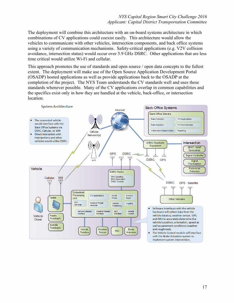
The deployment will combine this architecture with an on-board systems architecture in which combinations of CV applications could coexist easily. This architecture would allow the vehicles to communicate with other vehicles, intersection components, and back office systems using a variety of communication mechanisms. Safety-critical applications (e.g. V2V collision avoidance, intersection status) would occur over 5.9 GHz DSRC. Other applications that are less time critical would utilize Wi-Fi and cellular. This approach promotes the use of standards and open source / open data concepts to the fullest extent. The deployment will make use of the Open Source Application Development Portal (OSADP) hosted applications as well as provide applications back to the OSADP at the completion of the project. The NYS Team understands the CV standards well and uses these standards whenever possible. Many of the CV applications overlap in common capabilities and the specifics exist only in how they are handled at the vehicle, back-office, or intersection location.
NYS Capital Region Smart City Challenge 2016 Applicant: Capital District Transportation Committee
18
For example, many of the communication flows that exist in the architecture can be generalized down to a small set of core data flows:
• A vehicle collects data from its sensors (e.g. GPS, IMU, Weather, vehicle databus) and sends this out to other vehicles and back-office systems
• The back-office systems collect data from vehicles and CV infrastructure and fuse that data with traditional ITS data to create quality traveler information
• This traveler information is sent out to vehicles, dispatchers, the traveling public via traditional means as well as connected vehicle data flows
• Intersections and other potentially hazardous locations send out time-sensitive and location-sensitive information and warnings to the vehicles within communication range. These locations can also receive specific request messages from vehicles (e.g. signal request message for signal prioritization)
• Vehicles receive information from back-office systems, intersections, other roadside equipment, and other vehicles. This information serves as another sensor for the vehicle and the vehicle fuses this information with other data from its sensors and alerts, warns, and possible even intervenes with the driver.
Vision Element #11: Low-Cost, Efficient, Secure, and Resilient Information and Communications Technology (ICT). Approach & Proposed Technology Solutions The participating municipal partners are dedicated to, and will purse the idea of advanced communications technology (ICT) that is secure and can provide one common operating system for city government decision-making. The Team will work to determine the correct balance of data collection and privacy and security for optimal use of data. The Team will also look to the USDOT for support in use of and interfacing with the Security, Credential Management System (SCMS) prototype, and any other appropriate Personal Identifiable Information (PII) tools. Vision Element #12: Smart Land Use Approach & Proposed Technology Solutions • Smart Growth: As part of the NYS Capital Region Smart Cities vision, and under the leadership of the MPO, partners will support sustainable development patterns and site design, urban reinvestment, and community-based land use planning. Two key approaches will be used: Complete Streets, and Transit Oriented Development. Complete Streets: Transportation investments will be made based on a complete streets framework that supports the convenient and safe travel of all people — of all ages and abilities as appropriate to a facility’s community context. Utilizing a complete streets framework ensures that transportation investments are consistently planned, programmed, designed, operated and maintained with all users in mind – including bicyclists, public transportation vehicles and riders, pedestrians of all ages and abilities, and local delivery needs. Successful implementation of a complete streets framework will be achieved by working with municipalities to improve communication and coordination, training and education, design standards and other resources.
NYS Capital Region Smart City Challenge 2016 Applicant: Capital District Transportation Committee
19
Transit Oriented Development (TOD): Under any growth scenario, the benefits of concentrated development patterns are significant for the transportation system and for regional quality of life. Transit Oriented Development not only supports urban centers with concentrated development patterns but can further aid in reinvestment by supporting mixes of land uses at a walkable scale. In support of urban reinvestment and regional equity, CDTC has programmed significant funding for transportation projects in the cities. One important way that CDTC has supported land use planning is by sponsoring the Community and Transportation Linkage Planning Program (known as the Linkage Program). The Linkage Program provides funding for cities, towns, and villages to prepare and implement community-based transportation and land use plans consistent with New Visions principles. Through this program as well as CDTC’s Corridor Management Initiative, TOD studies have been completed in the City of Albany and the City of Schenectady. As the need for additional support for nodal development that supports walking and transit continues to increase and is include in the regional Smart Cities Vision, CDTC will continue to support projects that create areas for transit oriented development. 6. Key technical, policy, and institutional risks of deployment vision and mitigation On issue is that if municipalities don’t adopt TOD “friendly” land use regulations this impedes ability to expand compact development. The partners have experience working collaboratively in the past to obtain a desired outcome so it is likely that the region could overcome institutional risks in the future. 7. Team partners, key Stakeholders, and demonstration governance processes The NYS Capital Region Smart Cities team consists representatives of the City of Albany, the City of Schenectady, the City of Troy, and the City of Saratoga Springs, supported by their MPO, CDTC, the Capital District Transportation Authority (CDTA) and the New York State Department of Transportation (NYSDOT). CDTC will act as the applicant for the Smart Cities Challenge. As part of the NYS Capital Region Smart Cities Challenge Team, the NYSDOT, in partnership with the University Transportation Research Center Region 2 (UTRC) is proposing deployment of connected vehicle technology along two connected “Smart” corridors in the Capital Region. Stakeholders in the NYS Capital Smart Cities initiative fall outside of the City limits. The innovations and technological advancements being proposed in the Vision are all aimed at the areas four main City centers and the main transit corridors that transverses between them. Other stakeholders who are located and operate along these corridors, as listed within the table on the following page.
NYS Capital Region Smart City Challenge 2016 Applicant: Capital District Transportation Committee
20
Municipalities Colleges
and Universities
Business Imp.
Districts (BIDS)
Housing
Authorities
NY Route 5 BRT
Red Line
Albany &
Schenectady Counties
City of Albany
Town of Niskayuna
Town of Colonie
Village of Colonie
City of Albany
Schenectady County
Community College
(SCCC)
Central Avenue
Lark Street
Downtown Albany
Albany
Schenectady
Washington-
Western BRT
Purple Line
Albany County
City of Albany
Town of Guilderland
University at Albany
College of Saint Rose
SUNY Polytechnic
Central Avenue
Lark Street
Downtown Albany
Albany
River Corridor
BRT/ Blue Line
Albany, Saratoga
& Renssealer
Counties
City of Albany
Village of Menands
City of Watervliet
City of Troy
City of Cohoes
Village of Waterford
Rensselaer Polytechnic
Institute (RPI)
Sage Colleges
Downtown
Troy
Albany
Watervliet
Troy
Cohoes
Northway Xpress
Albany & Saratoga
Counties
Town of Milton
City of Saratoga
Springs
Town of Wilton
Town of Malta
Town of Clifton Park
Town of Halfmoon
City of Albany
Downtown Albany
Not
applicable
NYS Capital Region Smart City Challenge 2016 Applicant: Capital District Transportation Committee
21
8. Existing transportation infrastructure and system features
The makeup of the transportation Infrastructure for the Smart Cities geographic area is: principal arterials total 617 centerline miles and interstates total 252 centerline miles. Transit services: The Capital District Transportation Authority (CDTA) is a public benefit corporation that provides transportation and other services within Albany, Rensselaer, Saratoga and Schenectady Counties. CDTA has approximately 270 buses operating on 50 transit routes. The vast majority of CDTA’s trips are for work (over 70%) and the rest are for medical, educational or recreation purposes. Along with fixed route services, CDTA provides commuter express services and paratransit services for people with disabilities. Ridership has increased on CDTA services for four consecutive fiscal years, and is on pace to increase for a fifth. In fiscal year 2013-14, CDTA set a 30-year record for ridership with 17million annual boardings. A key contributor has been the implementation of twelve universal access agreements twelve with local colleges, universities, and employers. In the past five years, CDTA has also implemented several route restructuring initiatives, with ridership on the restructured routes increasing by 15% or more. The Route 5 BRT project increased ridership on the corridor by more than 20%. Shared-use mobility services: Travel demand management (TDM) refers to efforts to reduce auto travel and congestion by improving transit access, bicycle and pedestrian access, providing opportunities for carsharing, bikesharing, carpooling, vanpooling, and telecommuting, and other strategies. TDM reduces congestion, reduces the costs of driving, and it is an important way to reduce greenhouse gas emissions. CDTC strongly supports TDM by investing in transit, bicycle and pedestrian facilities, carpooling and land use planning. CDTC projects and investments that support TDM include federal funding for transit service in the Capital District is a major part of the CDTC TIP. New Visions incorporates CDTA’s Transit Development Plan, which will improve and grow a variety of transit services for the Capital District, increasing mobility and supporting economic development and smart regional growth. One example is CDTC’s investment in the BusPlus system on the Route 5 corridor. The MPO’s plan encourages development that incorporates bicycle and pedestrian accommodations into highway construction as well as city, village, and town plans and provides for recreational opportunities through creation of bike/hike trails. CDTC maintains the iPool2 Ride2gether website which offers a ride matching service and a one-stop shop for traveler needs, and the Capital Coexist website, a localized education campaign geared towards cyclists and motorists safely coexisting when using the region’s roadways. Capital CarShare, sponsored in Albany, has four cars available and two more on the way. Future expansion could include Troy, Schenectady and Saratoga Springs. Providing the opportunity to rent a car on an as needed basis makes not owning a car, or only owning one car in a household, more feasible. In 2014, CDTC sponsored four demonstration/trial weeks of Bike Share during the summer in Albany, Schenectady, Troy and Saratoga Springs. Investments in Park and Ride lots have also been supported by CDTC, CDTA, and NYSDOT. Lastly, the Guaranteed Ride Home- this program provides a taxi trip home for a bus rider or carpooler when they need to respond to an unexpected issue, such as picking up a sick child from school.
Information and communication technology (ICT): The participating municipal partners are dedicated to, and will purse the idea of advanced communications technology (ICT) that is
NYS Capital Region Smart City Challenge 2016 Applicant: Capital District Transportation Committee
22
secure and can provide one common operating system for city government decision-making. The Team will work to determine the correct balance of data collection and privacy and security for optimal use of data, and work with the Security, Credential Management System (SCMS). Operational Improvements/the Intelligent Transportation System (ITS) Priority Network Given the expense and difficulty of adding expressway capacity, and given the high demand for expressway usage that is forecast to continue to grow in the Capital District, it is clear that strategic investments in operational improvements will continue to be important to the future of the Capital District. ITS investments, including incident management and traveler information systems, will make the Capital District more accessible and will be important for maintaining the quality of travel. Emerging and future technologies hold promise, and analysis of future traffic growth and future conditions further underscores the importance of ITS and operational investments to provide important benefits to the traveling public. The identification of priority networks does not imply that improvements off the defined networks are not warranted or desirable. Flexibility is required in interpretation, so long as the basic message—these are important facilities—is not lost. The New Visions Plan identifies a network of expressway and arterial facilities as the platform for the regional ITS. There should be centrally coordinated traffic control and/or guidance along these facilities. The logic is that advising travelers of preferable alternatives before they enter the most congested areas and facilitating smooth flows along the alternatives can keep overall traffic conditions from worsening. The regional ITS priority network contains: priority expressways; arterials representing their immediate alternatives (ordinarily either parallel to or connecting the expressways); their secondary alternatives (which entail more surface street travel); and other arterials that are strategically important because they are important travel corridors, although they are not viewed as alternative routes for expressway travelers. The Regional Operations and Safety Advisory Committee was asked to review the ITS priority network and determine if updates were needed. One of the comments made by the Committee is that volume and crashes on roads within the priority network should be considered in evaluating funding priority. The CDTC project evaluation process already takes into account volumes, facility importance and potential crash reduction in evaluating and prioritizing projects. This concept will be further considered in the context of ITS projects as CDTC refines its project evaluation and selection process. The ITS priority network recognizes the importance of the expressway system, but the role of ITS on the arterial system is also important. Some ITS improvements to arterials, which parallel the expressways, will have direct benefits to expressway travel, especially by providing alternate routes during expressway incidents. Access management and physical improvements will be required for this to be effective. Nonetheless, ITS benefits from signal coordination, transit signal priority, or other improvements will also provide significant benefits to normal daily arterial function. The ITS network recognizes the importance of coordinating signal timing on major city and suburban arterials. Transit-friendly application of that technology will include designing the
NYS Capital Region Smart City Challenge 2016 Applicant: Capital District Transportation Committee
23
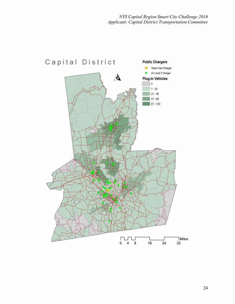
operation of the signal system to achieve multiple objectives. Rather than optimizing signal timing for maximum traffic flow, signal system design can be developed that allows for efficient traffic progression at travel speeds that are compatible with pedestrian, bike and transit movements. This may provide for a win/win outcome. Even modest improvements in basic signal timing will show important results. Implementation of signal coordination along arterial corridors will improve traffic flow for autos as well as for transit using Transit Signal Priority (TSP). Successful implementation of signal coordination along the Route 5 corridor in Albany, Colonie, Village of Colonie, Niskayuna and Schenectady has demonstrated the value of ITS for arterial performance. For routes that parallel expressways, ITS holds the promise of allowing the signal coordination and timing plan to be changed by the TMC to facilitate diverted traffic during an incident. The priority network was recently updated, and extends to the Saratoga County/Warren County border. It includes all routing in the 40 mile BRT system. The Route 5 portion continues to include the BusPlus BRT; while the updated Priority Network includes all routing for the Washington Western BRT and the River Corridor BRT. Smart Grid Infrastructure including electric vehicle charging infrastructure CDTA’s participation in the proposal would fully embrace the intent to build a robust Smart Grid Infrastructure with the deployment of electric buses. The electric vehicle charging infrastructure would be implemented at the termini of existing BRT routes, in addition to growing the network in the future. There are currently about 70 publicly accessible, Level 2 electric vehicle charging stations in the Capital District. Some workplaces and dealerships have installed private charging stations, while Tesla put in DC fast charging stations at Colonie Center. The following map from the Capital District Clean Communities Coalition shows the number of plug-in vehicles and the existing electric vehicle-charging infrastructure. Though infrastructure continues to expand, several gaps in the EV charging network remain. The Capital District EV Charging Station Plan identifies our 4 major cities and the Town of Colonie for infrastructure expansion, guidelines for locating publicly accessible DC fast charge stations, and recommendations for increasing EV purchases. EV-ownership in the Capital District is growing steadily and is anticipated to impact utilities and the grid. A smart grid is the key to “smart” EV charging, providing the visibility and control needed to protect components of the distribution network, such as transformers, from being overloaded by EVs and ensures electricity-generating capacity is used most efficiently. A smart grid will allow utilities to manage when and how EV charging occurs, adapt to customer preference, and apply special rates for EV charging. Special EV charging rates can create significant savings for EV-owners and make EVs attractive to potential customers. The current electric vehicle/charging station configuration is shown on the following page.
NYS Capital Region Smart City Challenge 2016 Applicant: Capital District Transportation Committee
24
�
NYS Capital Region Smart City Challenge 2016 Applicant: Capital District Transportation Committee
25
9. Data Collection
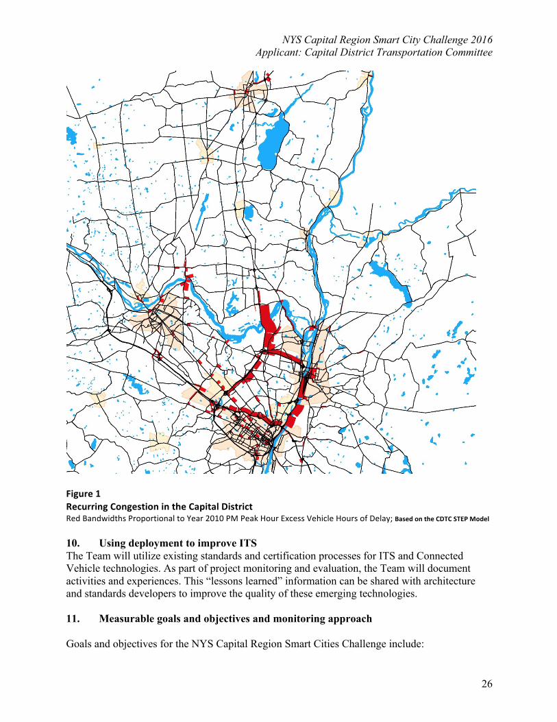
Working as a regional team, the 4 City partners rely heavily on the formalized processes and resources available through their project partners. The Team would seek to standardize and expand the types of information gathered in relation to Smart Cities, so as to achieve the maximum benefit from shared information and analysis. CDTC, CDTA and NYSDOT have significant experience in data collection as well as existing relationships with other agencies that require data sharing policies. The Team will seek support from its partners and USDOT in regards to collecting and safeguarding data as well as making deployment data available as appropriate to advance Smart City objectives. The New York State Department of Transportation (NYSDOT) through the Management Information System collects traffic data for Transportation (MIST) for a number of locations on the connecting corridors, the Northway, I-90, I-787 and Alternate Route 7, spanning across the 4 major cities. This system provides traffic count and speed and incident data for every 15-minute interval throughout the year. On the expressway system, delay is calculated as travel time in excess of travel time at 50 miles per hour. The MIST data system provides extensive monitoring of the four highest volume expressways in the Capital Region, but congestion also occurs throughout the region. CDTC maintains a travel demand model for the four county region, which is called the STEP Model (Systematic Transportation Planning and Evaluation Model). The STEP Model is based on population, housing and employment data and estimates traffic volumes based on demand. These estimated volumes are compared against actual traffic counts to validate the model. Figure 1 shows the STEP Model estimates of traffic congestion (excess vehicle hours of delay) in the Capital District. The STEP Model indicates that the worst congestion in the Capital District occurs on the four highest volume expressways that are covered by the MIST data. The model also indicates other locations along arterials in the cities and suburbs that are often related to intersection delays. CDTC has developed a “Congestion Management Process” (CMP) that identifies critical congestion locations (see Figure below).
NYS Capital Region Smart City Challenge 2016 Applicant: Capital District Transportation Committee
26
Figure 1 Recurring Congestion in the Capital District Red Bandwidths Proportional to Year 2010 PM Peak Hour Excess Vehicle Hours of Delay; Based on the CDTC STEP Model 10. Using deployment to improve ITS The Team will utilize existing standards and certification processes for ITS and Connected Vehicle technologies. As part of project monitoring and evaluation, the Team will document activities and experiences. This “lessons learned” information can be shared with architecture and standards developers to improve the quality of these emerging technologies. 11. Measurable goals and objectives and monitoring approach Goals and objectives for the NYS Capital Region Smart Cities Challenge include:
NYS Capital Region Smart City Challenge 2016 Applicant: Capital District Transportation Committee
27
Goal #1: Increase overall transportation system safety Objectives:
• Improve Pedestrian Safety (RT 5, RT 4/32) • Improve Pavement Quality/Maintenance (RT 5, RT 4/32 and I-87) • Improve NYSDOT Employee Safety (road maintenance workers) (RT 5, RT 4/32 I-87) • Improve Safety of Busses (RT 5, RT 4/32 and I-87) • Improve Safety of Maintenance Vehicles (RT 5, RT 4/32 and I-87) • Reduce crashes due to icy or unplowed roads (RT 5, RT 4/32 and I-87) • Reduce crashes as a result of queue build up (RT 5, RT 4/32 and I-87) • Reduce crashes due to high speed around a curve (roll overs/icy conditions) (I-87) • Improve ability to inform drivers of hazards such as grate crossings
Goal #2: Improved mobility for transportation system users Objectives:
• Reduce traffic congestion during rush hour period (RT 5, RT 4/32 and I-87) • Reduce major incident delays and manage diversions better (RT 5, RT 4/32 and I-87) • Improve Traffic & Weather Data Collection (RT 5, RT 4/32 and I-87) • Improve Traffic and Weather Information Dissemination (RT 5, RT 4/32 and I-87) • Improve Quality & Timeliness, Usefulness of Traveler Info (RT 5, RT 4/32 and I-87) • Improve Efficiency/Reliability of Bus Schedule (RT 5, RT 4/32 and I-87) • Improve Efficiency/Reliability of Plow Truck Routes (RT 5, RT 4/32 and I-87)
Goal #3: Reduced impact of the transportation system on the environment Objectives:
• Reduce maintenance vehicle fuel consumption (RT 5, RT 4/32 and I-87) • Reduce bus fuel consumption (RT 5, RT 4/32 and I-87) • Reduce maintenance vehicle emissions (RT 5, RT 4/32 and I-87) • Reduce bus vehicle emissions (RT 5, RT 4/32 and I-87) • Reduce use of salt on roadways (RT 5, RT 4/32 and I-87)
Goal #4: Improved transportation agency efficiency Objectives:
• Improve real-time information of NYSDOT maintenance vehicles and CDTA busses (NY Route 5, RT 4/32 and I-87)
• Reduce maintenance fleet downtime due to vehicle repairs (RT 5, RT 4/32 and I-87) • Reduce bus fleet downtime due to vehicle repairs (RT 5, RT 4/32 and I-87) • Improve Efficiency of Snow & Ice Operations (RT 5, RT 4/32 and I-87) • Improve Pavement / Roadway Condition Data Collection (RT 5, RT 4/32 and I-87) • Improve Pavement Quality/Maintenance (RT 5, RT 4/32 and I-87) • Improve Efficiency/Reliability of Bus Schedule (RT 5, RT 4/32 and I-87) • Improve Efficiency/Reliability of Plow Truck Routes (RT 5, RT 4/32 and I-87) • Reduce use of salt on roadways (RT 5, RT 4/32 and I-87)
NYS Capital Region Smart City Challenge 2016 Applicant: Capital District Transportation Committee
28
If selected for the demonstration, the Capital Region Smart Cities Challenge Team will assess the impact of the deployed CV applications and technologies using a set of key performance measures, which will be carefully selected to provide a comprehensive evaluation plan. The team will validate site system performance against the targeted measures, collect or infer contextual data to isolate and mitigate confounding factors, and provide supplementary evaluation on a broader set of safety, environmental, mobility and public agency efficiency measures as directed by USDOT. Evaluation based on real world collected data will serve as the cornerstones to both establish the base conditions as well as to allow for a thorough assessment of the CV applications and technologies. The team will support an independent evaluator’s access to the deployment site and project staff for evaluation-related experiments, interviews, and surveys.
12. Team Capacity The Capital Region Smart Cities Team includes the following entities:
uCity of Albany uCity of Schenectady uCity of Troy uCity of Saratoga Springs uThe Capital District Transportation Authority (CDTA) uThe Capital District Transportation Committee (CDTC) uThe New York State Department of Transportation (NYSDOT)
CDTC, as the applicant leading this multi-faceted team, has a 50 history of regional transportation cooperation and coordination. Our staff and our committees have assisted in the implementation of many regional transportation projects. Our members and our committee members, both public and private, have worked together to develop consensus on such large regional projects as the Route 5 BRT project in Albany, Colonie, and Schenectady, the Airport Area Road Relocation projects in Colonie, the Albany Nanotech Fuller/Washington Intersection Relocation in Albany, the Round Lake By-Pass/Access to Global Foundries in Saratoga County, the I-90 Exit 8 Connector, and others. The Team has the technical expertise, the regional cooperation structures, the major university resources, and the vision to further develop and to implement this project. We have strong support and a working relationship among all our team members. We are training the workforce of tomorrow at SUNY Polytechnic Institute in Albany and at Hudson Valley Community College in Troy. We have invested significant transportation funding in the infrastructure in our Smart City corridor, and the pavement and bridge conditions are all very good condition. And finally all our members have strong data and performance management capabilities especially being the State Capital in our New York State government and our universities. 13. Leveraged Resources The transit specific components of this application will leverage existing funding obtained by CDTA and CDTC at the regional, state, and federal level. This includes the TIGER program, TAP program, and future funding from the Federal Transit Administration’s Small Starts program for bus rapid transit. All are team members will dedicate significant in-kind resources towards the project, and we will partner with other jurisdictions, stakeholders, and universities. We will also seek other funding sources, such as federal transportation funding from CDTC and federal and state funding from the NYSDOT.