parks work session agenda
TRANSCRIPT

Town of Pittsboro Department of Parks & Recreation
Paul Horne – Parks Planner – PO Box 759, Pittsboro NC 27312 – (919)533-5480 – [email protected]
AGENDA
Board of Commissioners and Parks and Recreation Advisory Board Work Session
Topic: Draft Parks and Recreation System Master Plan (PRSMP)
October 10, 2018 – 6:30 PM
Background
August 13, 2018: The Board of Commissioners received a presentation of the PRSMP as well as the final
vision and implementation chapters
September 12, 2018: The Parks Plan Steering Committee & PARAB received a presentation of the PRSMP
September 24, 2018: The Board of Commissioners discussed the PRSMP at their regular meeting. The
discussion was structured around written feedback submitted by Commissioner Fiocco. The Board
scheduled this work session in order to continue the discussion in a more focused setting.
Discussion
Staff proposes that we aim for a meeting not to exceed three hours. To this end, an analysis of
Commissioner Fiocco’s questions noticed four major topics recurring in various forms. These were:
Greenprinting Program (goal – under 10 minutes) 6:35 – 6:45
Level of Service (goal – under 45 minutes) 6:45‐7:30
Local Park Prototype and Minimum Amenity Package (goal‐ under 20 minutes) 7:30‐7:50
Roles and Responsibilities of Town and Developers (goal – under 45 minutes) 7:50‐8:40
Indeed these are the topics with perhaps the most import.
It is proposed that we strive to cover each topic within the allotted amount of time, with any remaining
time ensuring that we address the remainder of Commissioner Fiocco’s written feedback as well as any
other discussions which may arise. The goal is to cover the four main topics within 2 hours, leaving 1
hour for the remaining discussion.
Recommendation
Engage in this discussion to come to a better and common understanding of the issues involved and
ideally reach consensus toward adoption of the Master Plan, including any proposed revisions.

1
Staff Responses to Questions and comments from Commissioner Michael Fiocco.
Comments/ Questions in Bold
Page 10 Need to define the various different parks.
Neighborhood
Local/Neighborhood
Rural/Neighborhood
Community Park
Regional Park
Page 11 Natural Areas RE: “The Town’s parks and recreation vision includes protection of the natural areas that are
crucial to maintaining the Town’s character, aesthetics, wildlife habitat, water quality, and
quality of life.”
Protected Natural Areas
States areas are crucial for maintaining Town's character. The Town's character is going to change with growth;
growth that is desirable.
Changing from a bedroom community with enormous retail leakage and reliance on residential tax base.
Other stated goals of sustainability are included in the document that promote economic sustainability and
control of sprawl.
Need to understand/state that Town character does not translate to preservation of a rural/suburban sprawl
dominated development pattern.
Response:
1) The densities and land use patterns associated with Chatham Park are distinctly and objectively of a
suburban nature. The development’s guiding paragons, such Reston Virginia, the Woodlands Texas, Cary,
NC, and even Alexandria Virginia are all suburban. Alexandria is the most urban of all and has Transit
Oriented Development (TOD) nodes with high tax per acre values around those vibrant nodes. The
proposed densities of CP will not support mass transit.
2) There are other sections of this plan that extol the benefits of denser more urban development patterns.
Greater densities allow for greater efficiencies in service provision, healthier communities, higher returns
on investment for the Town, area more marketable to the creative classes which drive innovation in
economy, etc. This plan is by no means advocating for suburban sprawl and would invite ROI calculations/
Cost of Services Analyses associated with alternative land use scenarios.
3) As cities increase their densities it becomes even more important to preserve Natural Areas, not less
important.
a. The goals of growth, greater concentrated densities and conservation of natural areas are
complementary not incongruous.
Page 11‐12 LEVEL OF SERVICE Maintenance of Existing Level of Service ‐ States LOS is 18 Acres of "developable park land" per 1,000 residents and further qualifies developable park land to include only land for active recreation use and excludes passive recreation use in the calculation for level of service. There's a disconnect between the acknowledged value of
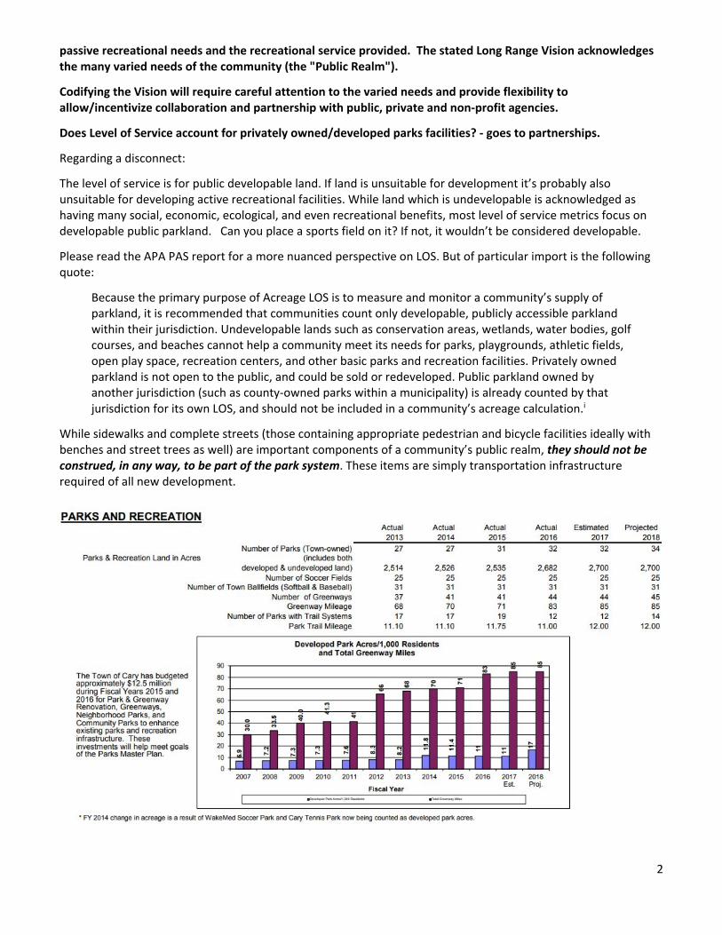
2
passive recreational needs and the recreational service provided. The stated Long Range Vision acknowledges the many varied needs of the community (the "Public Realm").
Codifying the Vision will require careful attention to the varied needs and provide flexibility to allow/incentivize collaboration and partnership with public, private and non‐profit agencies.
Does Level of Service account for privately owned/developed parks facilities? ‐ goes to partnerships.
Regarding a disconnect:
The level of service is for public developable land. If land is unsuitable for development it’s probably also unsuitable for developing active recreational facilities. While land which is undevelopable is acknowledged as having many social, economic, ecological, and even recreational benefits, most level of service metrics focus on developable public parkland. Can you place a sports field on it? If not, it wouldn’t be considered developable.
Please read the APA PAS report for a more nuanced perspective on LOS. But of particular import is the following quote:
Because the primary purpose of Acreage LOS is to measure and monitor a community’s supply of parkland, it is recommended that communities count only developable, publicly accessible parkland within their jurisdiction. Undevelopable lands such as conservation areas, wetlands, water bodies, golf courses, and beaches cannot help a community meet its needs for parks, playgrounds, athletic fields, open play space, recreation centers, and other basic parks and recreation facilities. Privately owned parkland is not open to the public, and could be sold or redeveloped. Public parkland owned by another jurisdiction (such as county‐owned parks within a municipality) is already counted by that jurisdiction for its own LOS, and should not be included in a community’s acreage calculation.i
While sidewalks and complete streets (those containing appropriate pedestrian and bicycle facilities ideally with benches and street trees as well) are important components of a community’s public realm, they should not be construed, in any way, to be part of the park system. These items are simply transportation infrastructure required of all new development.

3
The strongest rationale and most legally defensible method of establishing LOS is continuing the existing LOS, per the recommendation of this plan, which is for 18 acres of developable parkland per 1,000 people. Again, this is similar to the Town of Cary’s acreage LOS, for comparison.
Does Level of Service account for privately owned/developed parks facilities?
Yes and no:
No in the sense that communities typically only consider the facilities under its control within their LOS.
Yes in the sense that the full spectrum of recreational offerings need to be considered in order to have a more comprehensive view of the recreational needs of a community.
The excerpt from Boulder, CO’s Parks System Plan touches on both aspects of this:
Unless otherwise specified, the LOS discussions provided in this assessment are specific to BPRD; they are not applicable at a citywide level. The observations represent the extent to which BPRD, as one of multiple providers in the community, might address the demand for programs and facilities. For instance, the COB has a significant amount of open space; however, most of it falls under the management of Open Space and Mountain Parks department. While the LOS analysis in this plan certainly considers that fact as a part of the situational context, findings are focused on BPRD. The same principle is relevant to the analysis for recreation facilities and recreation programs.
There may be many providers of a particular service throughout the community, and the LOS analysis will describe the level at which BPRD might contribute to the overall availability in the community. In some cases, findings give input on the nature of delivery considering the possibility that some programs could be offered by contractors or formal partners rather than through direct provision by BPRD staff. In addition, the LOS must take into consideration the alternative services provided by other major institutions and the private sector. This includes population related to the University of Colorado, the Boulder Valley School District, non‐profit providers, private health clubs, neighboring golf courses, as well as other service providers in the region.ii
More clarity around public vs. private parks . . . via our consultant
Four proposals for the Town to consider: 1. Local Parks – We are proposing that local parks should be required infrastructure, the same as roads,
sidewalks, sewer, and water are required and built to your specifications. They should not “count” for anything – they are mandatory. The public or private question would pertain to maintenance and operations, not park land and construction. The new code would require the developer to “build and maintain +/‐ 2 acres of local parks per 1,000 new residents, in accordance with the Town’s prototype and specifications, so that every new resident can safely and comfortably walk to a +/‐ 6‐10 acre park within ½ mile of their home”. Period.
2. Maintenance of Local Parks – We have proposed that the Town require the developer to maintain local parks for perpetuity through an HOA; I don’t know why the Town would want to accept them, as long as they are built and maintained in accordance with your prototypes and specifications. It would be up to the developer to declare them public or private.
3. Fair Share of Community/ Regional Parks – We have proposed that developers pay their “fair share” of the larger community/regional parks, recreation centers, etc. that will serve the needs of new residents citywide. Fair share is typically measured in terms of acres and/or value. Your current acreage LOS is 18 acres of land per 1,000 residents. To calculate value, most studies that I’m familiar with estimate replacement costs for the existing system, including land, improvements and infrastructure. For example, if your system of public community/regional parks is worth $4,000,000 – and you have a population of

4
4,000 residents – then you are providing a LOS of $1,000 per person. Assuming a typical household size of 2.6 people, that would equate to a “fair share” of $2600 per new household.
4. Options for Payment – The developer’s fair share could be paid through impact fees, donation of suitable parkland, construction of improvements, or some combination of the three. It is assumed that the Town will assume responsibility for O&M, but the developer could also propose to offset some of those costs.
Each of these proposals are interrelated, and may need to be discussed and resolved separately to form a comprehensive approach to your park requirements. Hope this helps.
The above notwithstanding, how would private parks fit into our LOS? Per MAF:
Does Level of Service account for privately owned/developed parks facilities?
Privately owned parks or facilities would not be counted in the Public LOS. If development built and maintain +/‐ 2 acres of local parks per 1,000 new residents, in accordance with the Town’s prototype and specifications, within the established access LOS then one could reduce the Public LOS by 2 ie. 16 developable acres/ 1000 people.
One additional comment: In Florida, when Adequate Public Facilities regulations were required, there became creative ways of calling everything and the kitchen sink “parks.” Today many communities which lowered the definitions of developable parkland find themselves in a deficit and are now having to purchase additional land in order to meet community demand.
Page 15 Special Events along Greenways Don't understand how "special events and programs" fit into roadway design standards and land development codes?
Many communities have special events along their greenways, or hold “Open Street” festivals along their streets.
Page 17 Basic Park Amenities Suggests all new residential development build new parks in the development to include a long list of
amenities. Is this a list intended to be chosen from or to be included in each park?
Proposed park improvements fall into two categories: basic amenities and additional facilities. First, the Town should provide the following “basic amenity package” – based on residents’ needs and national trends - at all of the Town’s existing parks wherever feasible (physically and financially). Land development regulations should also require these amenities to be included in new parks constructed in new communities:
Safe and comfortable spaces Power, water, infrastructure for special
events Multipurpose open lawns Shade trees & canopies Paved, multi-purpose trail All types of seating, including moveable
tables and chairs Picnic shelters Playground for all ages Wi-Fi
Drinking water fountains Outdoor fitness equipment Multi-purpose courts for basketball, tennis,
and pickleball Restrooms Lawn games, such as horseshoes and
bocce Splashpads ADA, universal access Sidewalk/ Greenway Access
These would be included at each park. While the list is long, most of the items are easy to accommodate, such as walking trails, water fountains, ADA compliance, etc. Courts, shelters, restrooms and splash pads add expense, but increase the value of each facility exponentially. I should clarify that the active courts should not imply separate basketball, tennis, and pickleball court at each park, but rather at least one active recreation hard court,

5
which could serve multiple functions, though more than one may be desirable. This is a prototype and could be refined at the stage of codifying, but the key components are the core minimum amenities and the mix of active, passive and natural components ‐ a bit of something for all age groups and abilities.
Regulations will need to identify thresholds for which developments are required to provide and those that are not and alternatives for those developments unsuitable for recreation improvements.
Yes, you are right – this might be a good topic for Dr. Barth to elaborate on how those thresholds might work. I should point out that it would be possible to “build and maintain +/‐ 2 acres of local parks per 1,000 new residents, in accordance with the Town’s prototype and specifications, within the established access LOS,” on a parcel smaller than 10 acres. However, it is doubtful that anything below six would be able to accommodate the slate of required amenities. For reference Mary Hayes Barber Holmes Park is on 10 acres.
If all development must provide facilities how will that affect LOS calculations?
Privately owned parks or facilities would not be counted in the Public LOS. If development built and maintain +/‐ 2 acres of local parks per 1,000 new residents, in accordance with the Town’s prototype and specifications, within the established access LOS then one could reduce the Public LOS by 2 ie. to 16 developable acres/ 1000 people.
See additional detailed LOS discussion above.
Page 33 CAPRA Why is it important to meet the Standards of Commission for Accreditation of Park and Recreation Agencies? “Agencies cite many reasons for seeking external recognition of their operations, programs and services. The
following lists outline some of the most common reasons. Following this are testimonials attesting to the real
value of agency accreditation and how agencies universally report that the "benefits far outweigh the costs of
accreditation."
Benefits for the Public
Assurance and validation of well‐administered services in accord with approved professional practices
Potential for external financial support and savings to the public
External recognition of a quality governmental service
Holds an agency accountable to the public and ensures responsiveness to meet their needs
Improves customer and quality services
Benefits for the Agency
Public and political recognition
Increased efficiency and evidence of accountability
Answers the question, "How are we doing?" through extensive self‐evaluation
Identifies areas for improvement by comparing an agency against national standards of best practice
Enhances staff teamwork and pride by engaging all staff in the process
Creates an environment for regular review of operations, policies and procedures, and promotes
continual improvement
Forces written documentation of policies and procedures
CAPRA Accredited Agencies in NC
City of Durham
Greensboro
New Bern

6
Kannapolis
Mecklenburg County
Town of Cary
Town of Garner
Town of Morrisville
Union County
Town of Wake Forest
CAPRA accreditation is not a short term objective but it’s a worthy aspirational goal for the future.
Page 34 Aquatics Centers Community parks are identified as having a goal of being located within 3 miles of DU's. Priority 4 states the
same proximity goal for Aquatics Center. As such is it intended that all Community Parks include Aquatics
Centers?
No, not necessarily.
Page 36 Demographics Source of demographics indicating primary growth within PBO is projected to be > 65?
Unsure of the original demographic source however the following Urban Land Institute studyiii confirms this
national trend. Trend period from this source is indicated in the chart titles.

7
Page 38 Action Most Supported Explain statement that the "action most supported by residents is to acquire land to preserve natural areas"?
Good observation – the priority ranking and the “action most supported” were from two separate questions:
Respondents were given a list of 19 different actions that the Town of Pittsboro could take to improve
the Parks and Recreation system in the Town. For each potential action respondents were asked to
indicate whether they are “very supportive”, “somewhat supportive”, “not sure”, or “not supportive” of
each action.
Based on the sum of “very supportive” and “somewhat supportive” responses the four most supported
actions include: acquiring land to preserve large contiguous natural areas of significant natural or
ecological value (80%), further developing existing parks and recreation facilities (80%), developing new
greenways trails and enhancing connectivity between neighborhoods, shopping, parks, and other
destinations (79%), and acquiring land to support a regional trail along the Haw River (78%).
Respondents were then asked which four items they would be most willing to fund with their tax dollars.
Based upon the sum of respondents’ top four choices the two items they would be most willing to
support with their tax dollars include: developing new greenways trails and enhancing connectivity
between neighborhoods, shopping, parks, and other destinations (34%) and developing an aquatic
facility(ies) (pools or splashpads) (32%). The least supported item was developing new athletic fields and
courts.
Seventy percent (70%) of respondents indicated they would be willing to pay more taxes to fund the
potential actions that are most important to their household. Of those who would be willing to pay

8
more taxes 12% would be willing to pay $20 or more per month, 28% would be willing to pay $10‐$20
per month, 17% would be willing to pay $8‐$9 per month, 12% would be willing to pay $6‐$7 per month,
18% would be willing to pay $4‐$5 per month, and 11% would be willing to pay $1‐$3 per month.
Source: ETC Town of Pittsboro Parks and Recreation Needs Assessment Survey Report, Page xiv
Natural Areas is listed 6 in priority?
No, the numbering here just references the various sub‐sections of the overall Vision, they’re not ranked in any
particular order. Natural Areas ranked high in several survey questions: For instance:
For perceived benefits: “Respondents were given a list of 12 potential benefits of parks, recreation, and open
space systems and were asked to rank all 12 from most important to least important. Conservation of natural
areas and community character were the two potential benefits that respondents indicated were most
important.”
Likewise for ETC’s Investment Rankings for Amenities:
Page 38 As ‐ As Possible Amend second sentence, third paragraph to remove "as" "as possible"
I’m afraid I’m unable to find this reference ‐ page 38?
Page 38 Cost of Service Analyses and Land Value per Acre Need to acknowledge the balance/interest in the Town to grow its non‐residential tax base, the development
of Chatham Park per the Master Plan and the County's Comprehensive Plan that states to preserve the rural
character of the County is to focus development in the municipalities.

9
Growth/development is to be focused in Pittsboro and its ETJ and will become urbanized. This needs to be
acknowledged as a caveat to protecting natural areas to help inform the community expectations and
dialogue.
At a gross level, relative to the rest of the County, growth will be channeled to the municipalities. A finer grained
analysis allows for a healthy fiscal mix of land uses within the municipality. While the County Land Use Plan
didn't presume to inform actions within Pittsboro's jurisdiction, it did produce an informative draft land use
suitability analysis that extended within our jurisdiction.v
The County Land Use Plan also acknowledged your correct analysis about the net fiscal impacts associated with
different types of development. It states: "Different land uses can produce different fiscal impacts. Generally,
high‐density commercial or residential development produces net positive fiscal impacts. These types of projects
include research and office parks, industrial developments, high‐rise apartments, and condominiums. On the
other hand, retail and less‐dense residential developments typically produce a net negative fiscal impact."
Most Cost of Service Analyses assign a net neutral or slightly positive net positive for conservation lands because
they don't demand much in the provision of services.
Return on Investments ROI for Infrastructure and provision of services tend to greatly favor dense concentrated
growth. Raleigh’s Blue Ridge Plan or Urban3’s tax value studies offer great examples of such ROI based land use
studies.
See response to P11 Natural Areas above (p. 1)
The first page of the Chatham Park Master Plan states that “Chatham Park is envisioned as a comprehensive live‐
work‐play community that will preserve open space, create parks, establish vibrant village centers as focal points
for work, entertainment, shopping, dining and recreation and create attractive connections among
neighborhoods, businesses, schools and parks, both inside and outside Chatham Park.” That vision sounds in
alignment with the One Pittsboro Plan and highlights the conservation of natural areas.
Densification and conservation are complementary and symbiotic ‐ not at odds.
Ultimately, however, this is a plan to reflect community values and vision. This plan checked‐in after the needs
assessment draft chapters in order to make sure that the vision sub‐categories reflected the will of the Board/
community and no reservations were heard at that time.
Page 38 What would the Town do to pursue its advertisement as a regional outdoors recreation
destination? I would view this more from a strategic marketing perspective beyond just advertisement.
Create the Haw River Trail, and encourage its development beyond our jurisdiction. Invest in both terrestrial
trails and paddle access enhancements, then get the details right though great design.
Invest in conservation lands/ natural areas that can house rope courses, adventure programming, environmental
programming, etc.
Have a mix of buffers around the Haw in areas where people feel "away from it all" (far more than say Cary’s
Hemlock Bluffs) coupled with targeted areas of dense development quite close to the river per the New Belgium
Brewing Company in Asheville. Avoid the muddled middle in‐between.

10
This approach dovetails with my favorite marketing principle. John Crompton (Texas A&M/ Parks guru) describes
this principle known, as real positioning/ real repositioning as follows:
"Real repositioning is the most fundamental because the other strategies do not require changes in services, but
rather changes in communications about services. Crompton suggests that there should be an element of real
repositioning in any comprehensive attempt to change the image of a local leisure service."
I've used this principle to make strategic low‐cost but high‐value improvements to Rock Ridge Disc Golf Course
targeting data driven improvements based on extensive online player feedback. It remains one of the highest
ranked courses in the state.
Ultimately, the more you can create authentic, unique experiences, the more successful the results will be. Of
our natural resources, the Haw and its uplands are perhaps the most unique and not least easily reproduced
elsewhere.
We’ll have to work harder to conserve, strategically enhance, and market what we have because we’re not an
Asheville, or a Boulder, or Tahoe, where intense recreational opportunities abound. That’s why I find the
Razorback trail compelling – we’re on equal footing there, just lacking the investment.
Most of the above focused on marketing to the outside world, but linking Pittsboro’s dense vibrant destinations,
and others, via a series of complete streets, greenways, and a robust well‐developed park system is integral to
creating a great place, and great places attract the desired end results of any targeted marketing campaign,
whether that’s attracting retirees, a creative talent pool, a “Google,” etc., while simultaneous creating a great
place for existing residents.
Page 38 Nat Areas and LOS Will Natural Areas be included in proximity evaluations and level of service calculations?
No, though one could do that via an LOS separate from developable parkland. The strategic approach (for
conservation) recommended in the plan would be to target the most biologically significant conservation areas,
then link to them via a system of greenways, complete streets, and parks.
Page 41 Main Street Fifth paragraph under 7. Downtown…last sentence: replace "three" with "four"; add "organization" after
"are" and replace "development" with "vitality"
Changes made
Page 45 Capital Improvements Chart Is signage and wayfinding system only for parks & rec facilities?
I believe that opinion of costs is only for components of the park system.
Is the unit cost for Acquisition for New Community Parks supposed to include "per acre" after 50,000?
Yes presumably, thanks; that should be indicated in the table heading under unit cost to apply to the entire
column – noted in final mark‐ups
Basis/Rationale for per acre cost difference between Neighborhood and Community Park land?

11
Not sure – good question for our consultant
Do the Land Acquisition items include or exclude Chatham Park land dedication units?
Note that this answer has changed since my original response upon further reflection. The Table includes all
anticipated needs including those within Chatham Park. There is no way to accurately calculate Chatham Park’s
amount of land dedication to the Town from the Master Plan or relevant Additional Element. As written, the
Chatham Park masterplan discusses “parkland” which can be comprised of a mix of public or private lands, the
publicly dedicated land could be dedicated to a party other than the Town of Pittsboro.
Development of New Community Parks item indicates/suggests excluded.
That is correct, this table indicates the needs and makes no assumption about potential contributions or
obligations from Chatham Park, as they remain to be determined.
Should Athletic Fields Multi‐purpose Park with Fields note "included above"?
The current notation is: "included in costs of improvements to existing parks" The chart indicates the need but
we don't want to "double dip" since the funding is accounted for in the lump sums for Rock Ridge and Town
Lake Park. In other words the table is itemizing athletic fields but indicating that the costs are located elsewhere
in the table.
What are the 11,000 acres based upon previously prepared Greenprint Program?
The 11,000 acres represent the area within the natural resource conservation ordinance developed by the North Carolina Wildlife Resources Commission (NCWRC) and Nicholas Institute for Environmental Policy Solutions at Duke University for the Town of Pittsboro circa 2013. It identifies and encourages the conservation of the most sensitive wildlife habitats in the town and it’s ETJ. This Greenprinting component was part of a project “Planning Tools for Pittsboro.” This project’s output has been used to inform the Town’s Draft Unified Development Ordinance. Note that this is about 37% of the ETJ land area, which is very ambitious.
30% of Pittsboro’s 29,475 acres of ETJ would be about 8,843 acres.
25% of Pittsboro’s 29,475 acres of ETJ would be about 7,369 acres.
20% of Pittsboro’s 29,475 acres of ETJ would be about 5.895 acres. If the text isn’t clear, this should be heavily caveated and clarified such that the process, determining the most significant areas, the desired amount of conservation lands, are to be determined. The reference to the existing Greenprinting efforts should be to indicate that we have a pretty good starting point for refining these parameters and don’t have to start from scratch. What is source of $25,000/Acre estimate for Greenprint Lands Acquisition? That’s an approximate rate for raw unimproved land now. There were a few questions about land value assumptions so I’ll provide a more detailed answer here. CP bought their assemblage for about $8‐13K/ acre. Town granted zoning entitlements, added infrastructure/ commitments for adding infrastructure, and speculation, raised the values to around 25‐50K/ acre. That also roughly applies for

12
areas surrounding but not within CP. After improvements the $150K/acre plus is not an unreasonable assumption. This is based on conversations with local realtors. Also, this is a current snapshot, so values will fluctuate. Conservation land likely won’t get any cheaper. Cost of Small Urban Park estimated at $500,000/park. Since the land and improvement aren't separated I'm assuming that this reflects high value land costs (valuable enough to be listed in square foot terms rather than acres), as well as the improvements. But even a modest water feature is about 300K, so sure, 500k sounds about right for this level of planning. Page Vernon Park cost ~ $100,000? Reason for substantial disparity? Since this category doesn’t separate land from development this figure may combine both. Cost to Town for Page Vernon Land = $0/ 0.09 acres: Representative Cost/ Acre of land (no improvements) for 3 parcels surrounding Page Vernon Park: $302,128/ acre $472,727/ acre $3,340,000/ acre Mean of $1,371,618/ acre, or $123,446/ .09th of an acre. Land within the densest areas of Chatham Park should have much higher values. That’s a small park, maybe an ideal size is twice that. . . These are just land costs. . . Can Page Vernon Park accommodate another $100,000 of improvements? This is probably best to answer in terms of improvements we would have incorporated into the design had the budget been less constraining. These would have included:
Bluestone pavers in select portions of the hardscape to create more contrast and visual impact – can’t recall costs but they were simply prohibitive for our budget
A pergola following the curve of the knee wall would have been an additional 50K just for the product, not including installation.
We would have used engineered Silva Cellsvi for organized root control/ better stormwater management. These would have cost more but probably would balance out considering all lifecycle costs such as tree health and future hardscape movement. Again, not sure of the costs as they were simply prohibitive for what we had to work with.
Public Art
Additional Seating/ Tables
Additional Plantings
Modest water feature ‐ $300K So yes, the design was constrained by budget in ways that can’t be known because we didn’t spend energy designing beyond the means of the project. Could the park accommodate $100K in improvements now? Yes:
Public Art
13
Additional Seating/ Tables
Additional Plantings
Pergola
Concrete Foosball Table
Possibly a spray feature comparable to mister at MHBH Park
Water fountain
Phone charging stations
Little library What is the previously prepared Greenprint Program? Addressed in a prior question.
Page 47 Population Projections and time frame Include a time frame for 60k population. Do you have a time frame in mind? You might be better informed on the latest projections. We used and referenced the EIS prepared by the Wooten Company in many instances as that was the latest study produced. That should easily suffice for the five year life expectancy of this plan. That is not total Town "build‐out". Perhaps you are better informed on the latest projections. What numbers do you propose that we use here that are consistent with water/wastewater allocations, capacity studies, or other vetted projections?
Page 49 Service Delivery Models Should "determine the most appropriate model for organization and service delivery" prior to hiring staff as opposed to vice versa. Refer to 1‐2 year implementation plan and consider how realistic such a slate of activities is to accomplish with a staff of one. Determining a service delivery model requires a process which requires staff to manage said process. We need additional staff right now.
Page 50 Indoor Recreation Space What is source of data supporting 1.5 SF/resident for Indoor Recreation Space? Unsure, will consult with consultant. Also, a recreation center should be in the estimated capital costs, and perhaps elaborated upon more within this section. Community Park proximity of 3 ‐ 5 miles is different than text in Section 5? Was unable to find that discrepancy thus far, but trust your thoroughness. Consultant inquiry. How is it determined the demand for pools exceeds the national standard by more than double?

14
I think the language is just a bit confusing there. I believe the idea is that the first pool might be built at around a population size of 15,000 rather than waiting until 33,000. This is also based on survey demand; such variances are not uncommon.
Page 51 Reference to Parks and Open Space Vision: Change to Parks and Recreation Vision. OK – not left in final mark‐up draft to determine consultant’s intent here. There are sections in the plan dealing with providing both recreational programming as well as a conservation/ open space program. Is Open Space something other than Park land? Yes Reduce the Roles and Responsibilities such that specific statements that are more aligned with code language be restated as goal statements and remove statements regarding specific facilities. This section has been re‐reviewed and all read as goal statements from which polies and ordinances would follow accordingly. The section opens with the following: “As reported in Section 3 of this report, the Town’s Unified Development Ordinance (UDO) and Subdivision Regulations do not clearly define the role of developers in meeting the parks and recreation needs of new residents. The Town should work with a qualified planning consultant to help draft the UDO sections relevant to Parks, Recreation, Greenways, and Open Space in order to codify the broad guidance provided in this plan, including the following recommendations:”
The intent is clear that any recommendations fit within that context. Delete the Basis of Developer Contribution. This should be developed as part of the update to the Subdivision/UDO regulations. Again, this section clearly states that this would need to be developed as an update to the UDO. Nevertheless, this simple formula articulates the legal basis for most parks and/or recreation impact fees and is thus included as a guiding principle, should the Town decide to pursue impact fees as one tool and as one part of its rational planning for providing parks and recreation services in a fiscally responsible manner. Impact Fees always require a legally defensible study; so any program would need to be carefully developed by a firm specializing in establishing parks and recreation impact fees. Such a policy could yield around 50 million in impact fees assuming a population of around 60,000 people.
Page 52 Roles & Responsibilities Heading states "Public Recreation Lands" but developer role /responsibility includes maintenance.

15
Yes, you're right that is unclear; "public" should probably not be in the heading. Except in the sense that the private role in addressing local parks allows the Town to focus on the provision of the other aspects of the public park system, perhaps that was Barth's intent? Will make an inquiry. Is the developer/HOA maintaining publicly owned land? Or is land privately owned but accessible to the general public? The later. The idea is that development will provide the local parks land and improvements as basic infrastructure. The idea is also that people aren't going to be willing to drive to someone else's neighborhood to visit a local park, as they'll have their own public or private park within a 10 minute walk, which will meet the base minimum local park standards. Is a Regional Park of a character that the County is the partner for a Town facility? Regional Park not a Town facility? Not part of LOS calculation? So in the schema whereby you have a dual system of local or regional parks, the local parks are essentially neighborhood parks, while the regional parks could be community scale parks or larger district parks. Classically Community Parks would be municipal and District Parks would be provided by the County. The third column 2nd row should read "District" Parks. As such Community Parks, such as the 38 million dollar Pleasant Park in Apex referenced in the plan would be a Town Park and counted in its level of service. Detailed explanations of LOS have been addressed in prior questions and in the APA PAS Memo on LOS received by the Board.
5.21 Maps Suggest including the 3 mile radii/circles. OK Suggest including 3 mile mark in the scale. OK – circular part of ETJ is roughly 3 miles
5.20 Maps How were Sites chosen/designated to fulfill the 3 minute walk criteria? There seem to be clusters and voids?
The 10 minute walk criteria was based on the densities of the Land Use Plan and the CP Land Use Plan ‐ I agree
that the mapping will need to be tightened up. As a former GIS Analyst and cartographer I have a perhaps too
discerning eye.
Is a Community Park disqualified as a Park meeting the 3 minute walk criteria?
10 minute: But no, I think that could work, particularly within a more urban context – and by extension obviate
the need for a local park within the same proximity. The Community Parks would still want to have the base
core amenities, walking trails, benches, etc. as well as any specialized features so those universal needs would
be met. It would be important to have some more contemplative areas within the park to counter the more
active components, and maybe more neighborhood oriented pocket parks/ open squares nearby. You’d have

16
lights, noise, etc. but those would add some spice to life and would be fun design problems to solve. This could
be achieved more easily within a master planned community or PDD.
General Comments Correct spelling of Page Vernon throughout the document: not Paige.
Yes: found & replaced in final markup version
Improve quality of Maps/Exhibits. Legibility is a challenge in both print and electronic formats.
Agreed ‐ will reiterate
Staff initiated additions:
1) to “Framework to Ensure the Provision of Public Recreation Lands” Table (p54):
Downtown Park/ Cultural Arts
Develop a Downtown Park to serve as historic Pittsboro’s cultural center.
Promote cultural arts through programming
Development opportunities could be explored within or surrounding the park to foster commercial synergies per Dix Park in Raleigh, NC or Downtown Park in Cary, NC.
We had a downtown park as one of our sub‐visions, so it should have section in this table.
2) Added Reference to the Triangle Land Conservancy (p55): a. Work with environmental groups and conservation organizations, such as the Triangle Land
Conservancy, to create a natural lands protection committee (e.g. the Pittsboro Conservation Ordinance Committee) to establish an environmental land protection program;
i http://www.barthassoc.com/wp‐content/uploads/2017/01/Barth‐PAS‐Memo‐5_16.pdf ii https://www‐static.bouldercolorado.gov/docs/Boulder_NeedsAssessment_130424‐1‐201307021552.pdf iii http://uli.org/wp‐content/uploads/ULI‐Documents/DemographicStrategiesForRealEstate.pdf iv https://pittsboronc.gov/vertical/sites/%7B512CE168‐4684‐4855‐9CD9‐7D209FE775E3%7D/uploads/REPORT_‐_Town_of_Pittsboro_Parks_and_Recreation_Needs_Assessment_Survey_Report_(September_25_2017).pdf v http://www.chathamnc.org/home/showdocument?id=30791 vi http://www.deeproot.com/blog/blog‐entries/silva‐cell‐features‐explained