parks and recreation plan - menomonie658a84dc-eee8-4daa-86f3...parks and recreation plan 2013 –...
TRANSCRIPT

Adopted April 29, 2013 by:Menomonie Common Council
Planning Assistance Provided by:
Parks and Recreation Plan2013 - 2018
City of Menomonie

City of Menomonie Park Plan 2013-2018
City of Menomonie Parks and Recreation Plan
2013 – 2018
Prepared by:
The City of Menomonie Parks and Recreation Department
1412 6th Street Menomonie, Wisconsin 54751
Planning assistance provided by:
Cedar Corporation 604 Wilson Avenue
Menomonie, Wisconsin 54751

City of Menomonie Park Plan 2013-2018
TABLE OF CONTENTS Introduction ......................................................................................................... 1 Physical Setting and General Information ................................................................. 3 Historic Population ................................................................................................ 4 Population Characteristics ...................................................................................... 5 Median Age .......................................................................................................... 6 Population Projections ........................................................................................... 7 Planning a Park System ......................................................................................... 7 Park Standards ..................................................................................................... 9 Service Areas ....................................................................................................... 10 Park Classification Definitions ................................................................................. 12 Park and Trail Inventory and Classification ............................................................... 17 Park Signs ........................................................................................................... 22 Picnic Shelters ...................................................................................................... 22 Park Maintenance and Landscaping ......................................................................... 22 Naming of City Parks and Facilities .......................................................................... 22 Park Amenities ..................................................................................................... 24 Participation in Recreation Programs ........................................................................ 25 Bongey Park ........................................................................................................ 29 Brickyard Disc Golf Course ..................................................................................... 30 Brickyard Nature Area ........................................................................................... 31 Cedar-Rama Park ................................................................................................. 32 Dog Park ............................................................................................................. 33 Elmwood Park ...................................................................................................... 34 Fowler Court Park ................................................................................................. 35 Galloway Creek Park ............................................................................................. 36 Lakeside Park ....................................................................................................... 37 La Pointe Park ...................................................................................................... 38 Leisure Services Center Park .................................................................................. 39 Lion’s Game Farm ................................................................................................. 40 Miller Park ........................................................................................................... 41 Oakwood Heights Park ........................................................................................... 42 Park Circle ........................................................................................................... 43 Phelan Park ......................................................................................................... 44 Point Comfort Park ................................................................................................ 47 Ridgeway Park ..................................................................................................... 49 Riverside Park ...................................................................................................... 50 Sanna Park .......................................................................................................... 51 Veteran’s Memorial at Knapp Park ........................................................................... 53 Wakanda Park ...................................................................................................... 54 Whisper Ridge Park ............................................................................................... 60 Wilson Park ......................................................................................................... 61 Wilson Creek Park ................................................................................................. 63 Wolske Bay Park ................................................................................................... 64 Dunn County Recreational Park ............................................................................... 65 Lake Menomin Park ............................................................................................... 67 Stout Technology Park ........................................................................................... 69 Junction Trail ....................................................................................................... 70 Lakebank Nature Trail ........................................................................................... 71 Red Cedar Trail .................................................................................................... 72 2nd Street Historic Corridor ..................................................................................... 73 Menomonie Alliance Christian School ....................................................................... 74 Menomonie Middle School ...................................................................................... 75 Menomonie Senior High School ............................................................................... 76 River Heights Elementary School ............................................................................. 77 St. Joseph’s School ............................................................................................... 78

City of Menomonie Park Plan 2013-2018
St. Paul’s School ................................................................................................... 79 Oaklawn Elementary School ................................................................................... 80 Wakanda Elementary School .................................................................................. 81 UW-Stout Sports Complex ..................................................................................... 82 Sign Standardization ............................................................................................. 83 General Improvements for all Parks ......................................................................... 83 Priorities.............................................................................................................. 83 Ongoing Plan Recommendations ............................................................................. 86 Plan Implementation ............................................................................................. 86 Annual Review of the Plan ...................................................................................... 87
TABLES Table 1 Historical Population and Population Change: Dunn County by Minor Civil Division 4 Table 2 Estimated Population and Change ................................................................ 5 Table 3 Age and Sex Characteristics – City of Menomonie ........................................... 7 Table 4 Population Projections ................................................................................ 7 Table 5 Recommended Park Acreage ....................................................................... 9 Table 6 Park, Open Space, and Pathway Classifications .............................................. 12 Table 7 Inventory of Existing Public Park System ....................................................... 20 Table 8 Park Amenity Inventory .............................................................................. 24 Table 9 Menomonie Recreation Department Attendance – Winter Schedule ................... 25 Table 10 Menomonie Recreation Department Attendance – Fall Schedule ...................... 26 Table 11 Menomonie Recreation Department Attendance – Summer Schedule ............... 27 Table 12 Short Term Priorities ................................................................................ 84 Table 13 Mid Term Priorities ................................................................................... 84 Table 14 Long Term Priorities ................................................................................. 85
FIGURES Figure 1 Planning Process ...................................................................................... 1 Figure 2 Menomonie Area ...................................................................................... 3 Figure 3 Population per Age and Sex Group .............................................................. 6
MAPS Map 1 Park Classifications and Service Areas ............................................................ 11 Map 2 Park Ownership and Locations ....................................................................... 18 Map 3 Proposed Bike Network ................................................................................ 19 Map 4 Phelan Park Concept .................................................................................... 46 Map 5 Wakanda Park Amenities .............................................................................. 58 Map 6 Wakanda Park ............................................................................................. 59

City of Menomonie Park Plan 2013-2018
1
INTRODUCTION The City of Menomonie has a long history of providing exceptional parks and recreation services for its residents and residents throughout the area. In 2002, the City received national accreditation from the Commission for Accreditation of Park and Recreation Agencies (CAPRA) which is sanctioned by the National Recreation and Park Association. Adopted by the City of Menomonie, the 2013-2018 City of Menomonie Parks and Recreation Plan is a guide for park land acquisition and development in the community with the goal of maintaining the high standards already in place. This plan updates the 1995-2001, 2001-2005, and 2007-2012 Plans. The plan establishes a process to design a park system which functions as a unit to serve the community. A well-planned park system serves the community at three separate levels: 1. Geographic Area. Parks should be accessible to various neighborhoods in a
community. 2. Age Group. The outdoor recreation needs of children, young adults, mature
adults, and the elderly vary greatly. Considerations must be made for adequate facilities such as parking and access.
3. Activity Level. A good park system is designed to include areas for organized
activities with spectators, improvised sandlot games, and natural and scenic open space.
Meeting the geographic, age group, and activity level needs of the community requires an on-going effort on behalf of the City Council and Parks and Recreation Department. Population and development trends show there is increasing pressure on the local natural resources. The park system must be evaluated regularly to continue to protect the natural resources and serve the needs of the community. The park planning process is outlined in Figure 1. Figure 1 - Planning Process
1. Evaluate Park System 2. Establish Goals and Objectives 3. Inventory Park System 4. Evaluate Park Demand 5. Analyze Supply and Demand of Park Space and Amenities 6. Develop Conceptual and Site Plans 7. Implement Plan

City of Menomonie Park Plan 2013-2018
2
Public participation in the planning process is essential to designing a good park system. The needs of the general population must be served as well as the needs for handicapped, elderly, and minority populations. The City Council and Parks and Recreation Department are responsible for park planning in Menomonie. This plan was developed in meetings with the Menomonie Plan Commission and Parks and Recreation Department. The Park Plan was by the City Council, with preparation assistance from the City Administrator, Park Superintendent and Recreation Director. The Menomonie Park Plan examines the public park land in Menomonie. Approximately 200 acres of private park land also contributes to the ambiance of the community. This includes Chippewa Valley Golf Club, Pinewood Golf Course, Menomonie Country Club Golf Course, Moose Lodge Ball Diamond, and Lion's Club Game Park.

City of Menomonie Park Plan 2013-2018
3
PHYSICAL SETTING AND GENERAL INFORMATION Menomonie is the county seat of Dunn County. Located on Interstate 94 about 65 miles east of St. Paul, Minnesota and about 20 miles northwest of Eau Claire, Wisconsin, the City of Menomonie occupies more than 15 square miles. U.S.H. 12, S.T.H. 25, and S.T.H. 29 provide additional thoroughfares to and from the City (see Figure 2). The City is situated 805 feet above sea level and has an average mean temperature of 44 degrees Fahrenheit. Their average annual precipitation is 30 inches. The City of Menomonie is known for its scenic landscape. The most striking natural features are manmade Lake Menomin, the Red Cedar River, Wilson Creek, and numerous geological features. Designated as a third class municipality, Menomonie has a mayor, eleven member city council and plan commission. There are approximately 9,800 acres within the corporate limits. An estimated 3,900 acres of the city are undeveloped (City of Menomonie Comprehensive Plan). Figure 2 – Menomonie Area
Source: Google Maps

City of Menomonie Park Plan 2013-2018
4
HISTORIC POPULATION Understanding the population dynamics of a community is critical in park planning. The population determines the types of parks a community needs and population projections are helpful in planning for the future. City parks are not necessarily used exclusively by City of Menomonie residents therefore, it is important to look at population trends for the entire County to understand the number of potential users of the City’s park system (see Table 1). Table 1 - Population Growth-Dunn County Municipalities
Municipality 1990 2000 2010 Numerical Change
1990-2010 Percent Change
1990-2010
Towns Colfax 685 909 1,186 501 73.1%Dunn 1,297 1,492 1,524 227 17.5%Eau Galle 856 797 757 -99 -11.6%Elk Mound 772 1,121 1,792 1,020 132.1%Grant 400 426 385 -15 -3.8%Hay River 505 546 558 53 10.5%Lucas 635 658 764 129 20.3%Menomonie 2,725 3,174 3,366 641 23.5%New Haven 665 656 677 12 1.8%Otter Creek 344 474 501 157 45.6%Peru 221 247 242 21 9.5%Red Cedar 1,422 1,673 2,086 664 46.7%Rock Creek 673 793 1,000 327 48.6%Sand Creek 541 586 570 29 5.4%Sheridan 484 483 454 -30 -6.2%Sherman 729 748 849 120 16.5%Spring Brook 1,261 1,320 1,558 297 23.6%Stanton 637 715 791 154 24.2%Tainter 1,768 2,116 2,319 551 31.2%Tiffany 584 633 618 34 5.8%Weston 569 630 594 25 4.4%Wilson 517 500 531 14 2.7%Villages Boyceville 913 1,043 1,086 173 18.9%Colfax 1,110 1,136 1,158 48 4.3%Downing 269 257 265 -4 -1.5%Elk Mound 797 785 878 81 10.2%Knapp 421 421 463 42 10.0%Ridgeland 235 265 273 38 16.2%Wheeler 327 317 348 21 6.4%Cities Menomonie 13,547 14,937 16,264 2,717 20.1%County Dunn County 35,909 39,858 43,857 7,948 22.1%Source: 1990, 2000, and 2010 U.S. Census

City of Menomonie Park Plan 2013-2018
5
Historically, the City of Menomonie has experienced continuous population growth while many of the rural Towns and Villages surrounding the City have experienced varying degrees of growth. The surrounding Towns of Menomonie, Red Cedar, and Tainter have all experienced higher growth rates than the City. Population growth in the surrounding Towns is likely due to the desirable topography and water resources, availability of land, and easy access to retail and employment opportunities in the City of Menomonie (see Table 2). Table 2 - Estimated Population and Change
Municipality 1990 2010 Numeric Change
Percent Change
Town of Menomonie 2,725 3,366 641 23.5%Town of Red Cedar 1,422 2,086 664 46.7%Town of Tainter 1,768 2,319 551 31.2%City of Menomonie 13,547 16,264 2,717 20.1%Source: 1990 and 2010 U.S. Census
POPULATION CHARACTERISTICS Knowledge of the age composition of a population is vital to planning since age influences the time at which a person completes his schooling, enters the labor market, marries, forms a family, and retires from the labor force. Each of these events has implications for land use, housing, transportation, and other public facilities planning. Since each age group exerts different demands on society for facilities and services, it is important to know the number of persons in each age group historically and recognize trends. The needs of an older, more mature population are quite different from those of a younger, growing population. Figure 3 illustrates the population per age and sex group in 2010 for the City of Menomonie. There are two interesting population trends taking place in the City.
The largest age group is residents between 20 and 24. A majority of these residents are UW-Stout students.
Other than residents aged between 15 and 29, the distribution of residents in the remaining age groups does not vary greatly.

City of Menomonie Park Plan 2013-2018
6
Figure 3 – Population Per Age and Sex Group
Source: 2010 U.S. Census Bureau
The general population tends to stay physically active longer in life. This may indicate the need for active recreational opportunities will continue to be important. Some of these needs can be provided by the City of Menomonie park system while others, such as golf courses and health clubs, will be provided by local businesses. MEDIAN AGE A single measure of the relative difference in age structure between areas or time period can be obtained by use of a median age comparison. The median age is that age above and below which there are an equal number of persons. Comparative median age is shown for the City of Menomonie, Dunn County, and the State of Wisconsin between the years 1970 to 2010 (see Table 3). The City of Menomonie shows a very youthful median age due to the influence of University of Wisconsin-Stout students. The City's median age is 10 years lower than Dunn County and 15 years lower than the State’s median age.

City of Menomonie Park Plan 2013-2018
7
POPULATION PROJECTIONS Planning for the future requires population projections to base estimates for future demand for facilities and services. Table 4 shows population projections for the City of Menomonie, Town of Menomonie, Town of Red Cedar, Town of Menomonie, and Dunn County. The population for the City and surrounding area is projected to continue to grow. As the population grows, the number of parks users will also increase. This could create a demand for park space and amenities that the City may not be able to meet with existing facilities. Table 4 – Population Projections
2010 2015 2020 2025 2030 Percent Change
2010-2025 Town of Menomonie 3,366 3,953 4,227 4,491 4,739 40.7% Town of Red Cedar 2,086 2,285 2,482 2,675 2,856 36.9% Town of Tainter 2,319 2,792 3,026 3,255 3,470 49.6% City of Menomonie 16,264 16,875 17,643 18,364 19,009 16.9% Dunn County 43,857 46,975 49,503 51,911 54,103 23.4% Source: Wisconsin DOA
PLANNING A PARK SYSTEM The Menomonie Park Plan is designed to provide an achievable program for meeting outdoor recreation needs in Menomonie. This program consists of goals, objectives, policies/recommendations, and standards.
Goals are general targets to be achieved.
Objectives are more specific targets that have stated means for their attainment.
Policies/Priorities are guides to be used to attain goals and objectives. Policies may be developed and changed as needed.
Standards are yardsticks established by consensus or scientific authority as a test
of quality, dimension and achievement.
Table 3 – Comparative Median Age
Place 1970 1980 1990 2000 2010
City of Menomonie 23.2 22.5 23.5 23.2 23.4
Dunn County 24.9 25.4 28.5 30.6 33.5
State of Wisconsin 27.2 29.4 32.9 36.0 38.5
Source: U.S. Bureau Census

City of Menomonie Park Plan 2013-2018
8
The overall goals and objectives of the Park Plan are listed below.
Goal 1: Provide quality handicap accessible park facilities and varied recreational opportunities to meet the needs of Menomonie residents now and in the future. Objectives:
1. Improve existing park facilities as necessary.
2. Acquire land in fee or by easements for needed parks.
3. Coordinate public parks and recreation areas with other land uses.
4. Cooperate with other local units of government and the state and federal governments in park planning
5. Formulate an action plan to meet the identified park needs.
6. Perform periodic reviews for improvement of Menomonie's recreation programs,
goals, objectives and policies.
7. Develop a coordinated system of parks.
8. Maintain the quality of recreational facilities.
9. Coordinate Menomonie's recreation program with the programs of other levels of government and private enterprise.
10.Encourage quality development of privately owned recreation facilities.
11.Provide a variety of recreation opportunities for the disadvantaged, young, old and
handicapped.
12.Assure that new subdivisions consider parks and recreation in their plans.
13.Participate in federal and state financial aid programs.
14.Facilitate various activities in community parks.
15.Maintain existing fencing, picnic shelters, and restrooms at park facilities.
16.Protect and improve the quality of life for City and area residents.

City of Menomonie Park Plan 2013-2018
9
Goal 2: Add a provision for non-resident use of city recreation programs. Objectives:
1. Include a provision for a recreational and tourism program that is designed to enhance the City's economy.
2. Continue to evaluate the impact of non-resident visitors and tourists on the local
economy and recreation facility use. Goal 3: Preserve and protect Menomonie's open space and water resources. Objectives:
1. Identify and preserve sites having scientific, historic, scenic or archaeological significance.
2. Protect resources by acquisition, easements, zoning and legislation.
3. Combine resource protection with park and recreation development.
4. Protect Menomonie's open space and water resources from visual blight and
degradation.
PARK STANDARDS One way to measure the adequacy of a community's park program is to determine the number of people it serves or has the capacity to serve. By assigning an acreage requirement for each type of park for each 1,000 persons in a community, its present and projected capacity can be evaluated. The optimum acreage for parks per 1,000 persons varies. Different planning sources set different criteria and standards. For planning purposes, the Parks and Recreation Department will use a common standard of 15 acres of parkland per 1,000 persons (see Table 5). This acreage should be distributed throughout the community so all residential areas, age groups and activity levels are served.
Currently, there are approximately 832 acres of park and recreation areas and trails in the City of Menomonie. Not all of these areas are developed or owned by the City. Based on an estimated population of 16,264 in 2010, there is approximately 51.2 acres
Table 5 – Recommended Park Acreage Per 1,000 Persons
Acres
Neighborhood Parks 5.0
Community Parks 10.0
Total 15.0

City of Menomonie Park Plan 2013-2018
10
of park and recreation areas and trails per 1,000 persons. This far exceeds the standards that have been set for the City. Also, many new subdivisions have private parks or open space for residents within those subdivisions. SERVICE AREAS Service capabilities of parks are best described in terms of their service areas. For example, the service area radius for neighborhood parks is one-quarter to one-half mile and one-half to three miles for community parks. These two park classifications serve a majority of residents adjacent to them. Typically, residents will walk or bike to these areas. Service area radii determine the effectiveness of a park in meeting local recreational demands. Man-made and natural obstacles may form physical barriers to recreational facilities within the community. These obstacles diminish the service areas of neighborhood parks and restrict their effectiveness. Normally, such obstacles do not have a similar impact on the effectiveness of large parks. Map 1 shows service areas for neighborhood parks and community parks. The map indicates that there are enough community parks to serve City residents but are few neighborhood parks on the northern and southern ends of the City although residents in these areas have access to other types of park and recreation areas.

City of Menomonie Park Plan 2013-2018
12
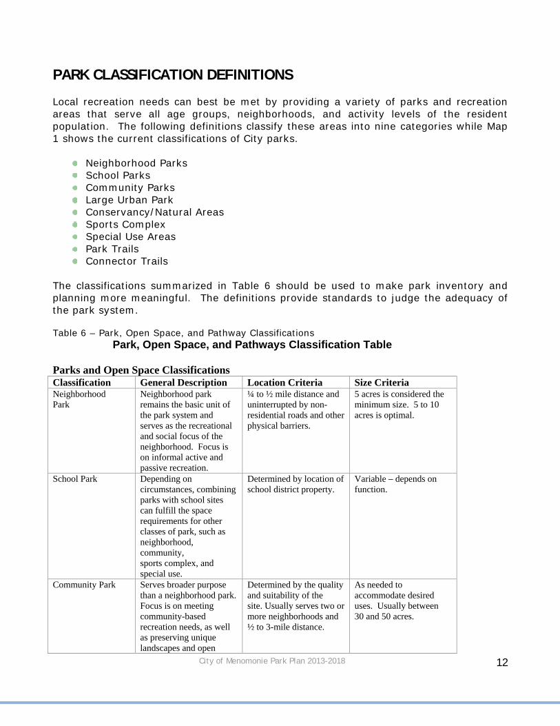
PARK CLASSIFICATION DEFINITIONS Local recreation needs can best be met by providing a variety of parks and recreation areas that serve all age groups, neighborhoods, and activity levels of the resident population. The following definitions classify these areas into nine categories while Map 1 shows the current classifications of City parks.
Neighborhood Parks School Parks Community Parks Large Urban Park Conservancy/Natural Areas Sports Complex Special Use Areas Park Trails Connector Trails
The classifications summarized in Table 6 should be used to make park inventory and planning more meaningful. The definitions provide standards to judge the adequacy of the park system. Table 6 – Park, Open Space, and Pathway Classifications
Park, Open Space, and Pathways Classification Table
Parks and Open Space ClassificationsClassification General Description Location Criteria Size Criteria Neighborhood Park
Neighborhood park remains the basic unit of the park system and serves as the recreational and social focus of the neighborhood. Focus is on informal active and passive recreation.
¼ to ½ mile distance and uninterrupted by non-residential roads and other physical barriers.
5 acres is considered the minimum size. 5 to 10 acres is optimal.
School Park Depending on circumstances, combining parks with school sites can fulfill the space requirements for other classes of park, such as neighborhood, community, sports complex, and special use.
Determined by location of school district property.
Variable – depends on function.
Community Park Serves broader purpose than a neighborhood park. Focus is on meeting community-based recreation needs, as well as preserving unique landscapes and open
Determined by the quality and suitability of the site. Usually serves two or more neighborhoods and ½ to 3-mile distance.
As needed to accommodate desired uses. Usually between 30 and 50 acres.

City of Menomonie Park Plan 2013-2018
13
space. Large Urban Park
Large urban parks serve a broader purpose than community parks and are used when community and neighborhood parks are not adequate to serve the needs of the community. Focus is on meeting community based recreational needs, as well as preserving unique landscapes and open spaces.
Determined by the quality and suitability of the site. Usually serves the entire community.
As needed to accommodate desired uses. Usually a minimum of 50 acres, with 75 or more acres being optimal.
Conservancy/ Natural Areas
Lands set aside for preservation of significant natural resources, remnant landscapes, open space, and visual aesthetics/ buffering.
Resource availability and opportunity.
Variable.
Sports Complex Consolidates heavily programmed athletic fields and associated facilities to larger and fewer sites strategically located throughout the community.
Strategically located community-wide facilities.
Determined by projected demand. Usually a minimum of 25 acres, with 40 to 80 acres being optimal.
Special Use Areas Covers a broad range of parks and recreation facilities oriented toward single-purpose visit.
Variable – dependent on specific use.
Variable.
Pathway Classifications Classification General Description Location Criteria Park Trails Multipurpose trails located within
greenways, parks, and natural resource areas. Focus is on recreational value and harmony with natural environment.
Type I: Separate/singlepurpose, hard-surfaced trails for pedestrians or bicyclists/in-line skaters. Type II: Multipurpose, hardsurfaced trails for pedestrians and bicyclists/in-line skaters. Type III: Nature trails for pedestrians. May be hard- or soft-surfaced.
Connector Trails Multipurpose trails that emphasize safe travel for pedestrians to and from parks and around the community. Focus is as much on transportation as it is on recreation.
Type I: Separate/singlepurpose, hard-surfaced trails for pedestrians or bicyclists/ in-line skaters located in independent r.o.w. (e.g., old railroad r.o.w.) Type II: Separate/single purpose, hard-surfaced trails for pedestrians or bicyclists/in-line skaters. Typically located within road r.o.w.
Source: NRPA’s Parks, Recreation, Open Space, and Greenway Guidelines

City of Menomonie Park Plan 2013-2018
14
Neighborhood Park Neighborhood parks remain the basic unit of the park system and serves as the recreational and social focus of the neighborhood. The focus is on informal active and passive recreation. Neighborhood parks in the City of Menomonie are:
1. Elmwood Park 2. Park Circle 3. Wilson Park 4. Leisure Service Center 5. Fowler Court Park
School Parks Depending on circumstances, combining parks with school sites can fulfill the space requirements for other classes of park, such as neighborhood, community, sports complex, and special use. Typically, school parks are not open to the public during normal school hours or during school events. School parks in the City of Menomonie are:
1. Menomonie Alliance Christian School 2. Oaklawn Elementary School 3. Menomonie Middle School 4. St. Joseph’s Catholic School 5. St. Paul’s Evangelical Lutheran School 6. River Heights Elementary School 7. Wakanda Elementary School
Community Parks Community parks serve broader purpose than neighborhood parks. Focus is on meeting community-based recreation needs, as well as preserving unique landscapes and open space. Many community parks in the City of Menomonie have boat landings to access Lake Menomin and shelters for people to use. Community parks in the City of Menomonie are:
1. Point Comfort Park 2. Riverside Park 3. Lakeside Park 4. Wolske Bay Park

City of Menomonie Park Plan 2013-2018
15
Large Urban Parks Large urban parks serve a broader purpose than community parks and are used when community and neighborhood parks are not adequate to serve the needs of the community. Focus is on meeting community based recreational needs, as well as preserving unique landscapes and open spaces. These parks attract users outside the community as well.
Large Urban parks in the City of Menomonie are:
1. Wakanda Park 2. Lion’s Game Farm 3. Phelan Park
Conservancy/Natural Areas This refers to lands set aside for preservation of significant natural resources, remnant landscapes, open space, and visual aesthetics/ buffering. Conservancy/natural areas may be used for passive recreation or may remain undeveloped. Conservancy/Natural areas in the City of Menomonie are:
1. Lake Menomin Park 2. Ridgewood Heights Park 3. Stout Technology Park 4. Oakwood Heights Conservancy Area 5. Galloway Park 6. Bongey Conservancy Area 7. Miller Park 8. La Pointe Park 9. Wilson Creek Park 10.Brickyard Nature Area

City of Menomonie Park Plan 2013-2018
16
Sports Complex Sport Complexes consolidate heavily programmed athletic fields and associated facilities to larger and fewer sites strategically located throughout the community. The complexes may be used for university and Menomonie School District athletics, regional tournaments, community recreation, etc. Sports Complexes in the City of Menomonie are:
1. Dunn County Recreation Park 2. UW-Stout Sports Complex 3. Menomonie Senior High School/Field House
Special Use Areas
These cover a broad range of parks and recreation facilities oriented toward single-purpose visit. Special use areas in the City of Menomonie are:
1. Cedar-Rama Park 2. Veterans Memorial at Knapp Park 3. Brickyard Disc Course 4. Dog Park
Private Parks These are limited in use by members or land owners. Private Parks in the City of Menomonie are:
1. Whisper Ridge Park Park Trails Park trails are multipurpose trails located within greenways, parks, and natural resource areas. Focus is on recreational value and harmony with natural environment. Park trails in the City of Menomonie are:
1. Red Cedar Trail 2. Junction Trail
City of Menomonie Park Plan 2013-2018
17
Connector Trails Connector trails are multipurpose trails that emphasize safe travel for pedestrians to and from parks and around the community. Focus is as much on transportation as it is on recreation. Connector trails in the City of Menomonie are:
1. Lakebank Nature Trail 2. 2nd Street Historic Corridor
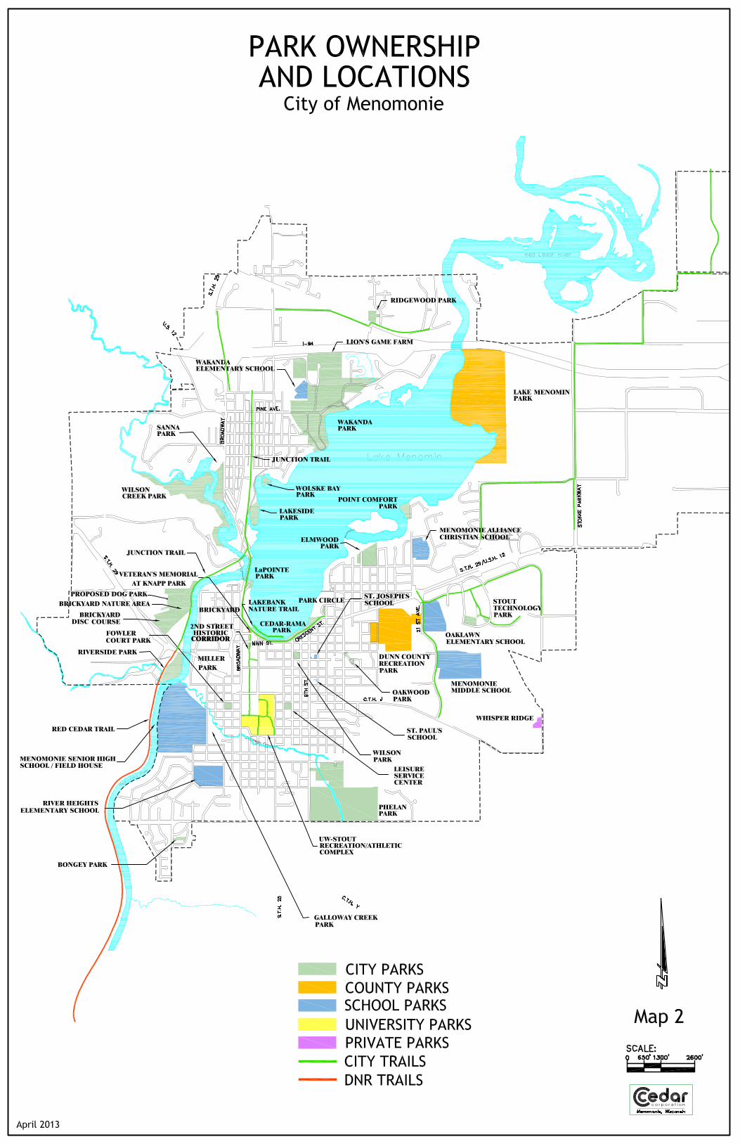
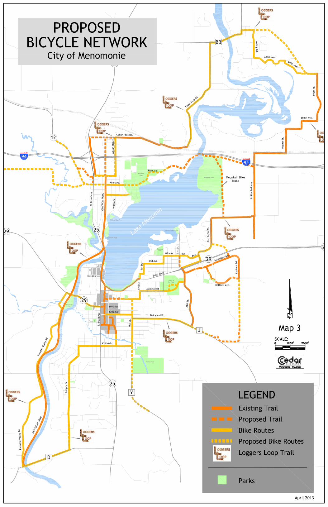
PARK AND TRAIL INVENTORY AND CLASSIFICATION Table 7 and Map 2 provide an inventory of the park system by park type and ownership. Map 3 shows the existing bike trails in the City of Menomonie area including proposed trails and routes as well as a proposed main bike route that would be signed and promoted. The City of Menomonie owns approximately 380 acres of park land. As may be expected, the largest acreage of city park land is in the large urban park category and consists of 223.3 acres. Neighborhood parks constitute a small percentage of total acreage of city park land with 15.9 acres. There are 26.4 acres of community parks owned by the City. Other areas that complement the City of Menomonie’s park and recreation opportunities are:
The county, schools, UW-Stout, and state parks complement the City parks to a great degree.
Dunn County Recreation Park is the home of the County Fair and draws residents and out-of-town visitors year around for activities at its arena.
The playgrounds at the local schools fulfill a geographic need for neighborhood parks and active recreation areas.
Don and Nona Williams Stadium is used for UW-Stout football and other sports. It provides many recreational opportunities for the City.
The Red Cedar Trail which starts in Menomonie and follows the Red Cedar River along a former railroad bed is an asset to the community. The trail is approximately 11 miles long and passes through Irvington, Downsville, Dunnville, and ends in Durand by the Chippewa River. The Red Cedar Trail connects to the Chippewa Trail which takes bicyclists to Eau Claire. Eventually, the trail will also lead to the City of Chippewa Falls. About 1/4 mile of the trail is in the City of Menomonie.

City of Menomonie Park Plan 2013-2018
20
Table 7 – Inventory of Existing Public Park System, Park Identification, Classifications , and Acreages
County Park & Rec. Lands
Neighbor-hood Parks
Com. Park
School Parks
Sports Complex
Large Urban
Trail System
Special Areas
Cons. Natural Areas Total
Dunn County Rec Park --- --- --- 53.8 --- --- --- --- 53.8
Lake Menomin --- --- --- --- --- --- --- 151.6 151.6
Subtotal 0 0 0 53.8 0 0 0 151.6 205.4
Local School Parks
Neighbor-hood Parks
Com. Park
School Parks
Sports Complex
Large Urban
Trail System
Special Areas
Cons. Natural Areas Total
Junior-Senior High --- --- --- 93.4 --- --- --- --- 93.4 Menomonie Middle School --- --- 40.1 --- --- --- --- --- 40.1
River Heights --- --- 19.8 --- --- --- --- --- 19.8
Wakanda School --- --- 6.1 --- --- --- --- --- 6.1
Oaklawn School --- --- 20.9 --- --- --- --- --- 20.9
St. Paul's --- --- 0.1 --- --- --- --- --- 0.1
St. Joseph's --- --- 0.4 --- --- --- --- --- 0.4 Menomonie Alliance --- --- 10.9 --- --- --- --- --- 10.9
SUBTOTAL 0 0 98.3 93.4 0 0 0 0 191.7
UW-Stout Parks Neighbor-hood Parks
Com. Park
School Parks
Sports Complex
Large Urban
Trail System
Special Areas
Cons. Natural Areas Total
UW-Stout Sports Complex --- --- --- 30.4 --- --- --- --- 30.4 Stout Technology Park --- --- --- --- --- --- --- 5.9 5.9
SUBTOTAL 0 0 0 30.4 0 0 0 5.9 36.3 State of Wisconsin Parks
Neighbor-hood Parks
Com. Park
School Parks
Sports Complex
Large Urban
Trail System
Special Areas
Cons. Natural Areas Total
Red Cedar Trail --- --- --- --- --- 2 --- --- 2
SUBTOTAL 0 0 0 0 0 2 0 0 2
Private Parks Neighbor-hood Parks
Com. Park
School Parks
Sports Complex
Large Urban
Trail System
Special Areas
Cons. Natural Areas Total
Whisper Ridge 2.3 --- --- --- --- --- --- --- 2.3
SUBTOTAL 2.3 0 0 0 0 0 0 0 2.3

City of Menomonie Park Plan 2013-2018
21
City Park & Rec. Lands
Neighbor-hood Parks
Com. Park
School Parks
Sports Complex
Large Urban
Trail System
Special Areas
Cons. Natural Areas Total
Wakanda Park --- --- --- --- 99.5 --- --- --- 99.5
Riverside Park --- 12.2 --- --- --- --- --- --- 12.2 Point Comfort Park --- 4.4 --- --- --- --- --- --- 4.4
Sanna Park --- --- --- --- --- --- 8.9 --- 8.9
Wilson Park 1.6 --- --- --- --- --- --- --- 1.6
La Pointe Park --- --- --- --- --- --- 1.5 --- 1.5
Park Circle Park 0.6 --- --- --- --- --- --- --- 0.6 Oakwood Heights Cons. Area --- --- --- --- --- --- --- 0.6 0.6
Ceda-Rama --- --- --- --- --- --- 8.6 --- 8.6
Elmwood 10.5 --- --- --- --- --- --- --- 10.5
Fowler Court 1.6 --- --- --- --- --- --- --- 1.6
Phelan Park --- --- --- --- 97 --- --- --- 97 Leisure Service Center Park 1.6 --- --- --- --- --- --- --- 1.6 Wilson Creek Park --- --- --- --- --- --- --- 52.6 52.6 Galloway Creek Park --- --- --- --- --- --- --- 3.4 3.4
Lakeside Park --- 6.9 --- --- --- --- --- --- 6.9
Wolske Bay Park --- 2.9 --- --- --- --- --- --- 2.9 Brickyard Disc Course --- --- --- --- --- --- 11.4 --- 11.4 Veterans Memorial at Knapp Park --- --- --- --- --- --- 0.05 --- 0.05
Miller Park --- --- --- --- --- --- --- 4.2 4.2 Bongey Cons. Area --- --- --- --- --- --- --- 1.1 1.1
Junction Trail --- --- --- --- --- 3.0 --- --- 3.0 Lakebank Nature Trail --- --- --- --- --- 0.15 --- --- 0.15 Park at Ridgewood Heights --- --- --- --- --- --- --- 3.3 3.3 Brickyard Nature Area --- --- --- --- --- --- --- 18.0 18.0 Lion’s Game Farm --- --- --- --- 26.4 --- --- --- 26.4
Dog Park --- --- --- --- --- --- 11.2 --- 11.2 2nd Street Historic Corridor --- --- --- --- --- 0.24 --- --- 0.24
Subtotal 15.9 26.4 0 0 223.3 8.39 41.65 65.2 398.8
TOTAL 18.2 26.4 98.3 177.6 223.3 10.39 41.65 222.7 834.5 ( ) Useable acreage is area which is accessible and moderately sloped

City of Menomonie Park Plan 2013-2018
22
PARK SIGNS The City of Menomonie park directional signs are created by the Menomonie Street Department. Each sign has a symbol on top that represents a significant feature of that park. The symbol on the Wilson Park sign represents the City’s band shelter that is home to the Ludington Guard Band, which holds outdoor concerts in the summer. It is recommended that standardized signs for all parks should be made. PICNIC SHELTERS For parks that contain picnic shelters, the City of Menomonie has implemented “Park Shelter Reservation Procedures”. These rules are available from the Menomonie Recreation Department and specify the hours the shelters are available for use, price of rental, permitted uses, and responsibilities of users. PARK MAINTENANCE AND LANDSCAPING The City of Menomonie Parks and Recreation Department is responsible for maintaining the parks and mowing all City owned property. Flower planting in Cedar-Rama Park, Lakeside Park, and Wilson Park is done by the Menomonie Woman’s Club. The Club is also responsible for the hanging flower baskets in the downtown area during the summer. The Parks and Recreation Department would like to utilize other groups such as the Menomonie Woman’s Club to help beautify other parks. NAMING OF CITY PARKS AND FACILITIES While the naming of City Parks will ultimately be the decision of the City Council. The Recreation Advisory Board and the Plan Commission shall use the following guidelines in making a recommendation to the City Council. The purpose of this policy is to provide a consistent method for naming or making name changes to public parks, public land or recreation facilities. Names should identify significant historical, geological and ecological areas located within the City. Also, appropriate recognition to individuals who have contributed to the growth and development of the City should be considered. Goals and Objectives for naming:
The names must be purposeful, suitable, symbolic, uncontroversial and must fall under one of the classifications of this policy.
If possible, names of facilities should be adopted before dedication or development begins for a new facility.
Names will not be for living persons.
City of Menomonie Park Plan 2013-2018
23
Classifications: Places and features including but not limited to:
Ü natural phenomenon, Ü recognizable area or neighborhood, Ü descriptive, Ü horticultural, Ü assumed name
Historic Events including but not limited to: Ü battles, Ü discoveries, Ü explorations, Ü community development
Organizations including but not limited to: Ü civic, Ü veterans, Ü fraternal, Ü other
Persons Name including but not limited to: Ü large donors, Ü historical groups, Ü local war heroes, Ü national war heroes, Ü national officials, Ü state officials, Ü local official, Ü local individual
Great Ideas or Causes including but not limited to: Ü ecological, Ü friendship, Ü independence, Ü peace
A group may ask to adopt a park or recreation facility for improvement or maintenance purposes, and in return, the park or facility could be named after that group. A written agreement should be signed specifically detailing the future responsibilities of the group adopting the park or facility and any name change must first be approved by the City Council. It may be appropriate in some cases to name subsections of parks to honor or pay tribute. This shall include ball fields and areas. Naming shall follow the above procedures. Plaques and markers shall be used to recognize individuals that contributed to the growth and development of areas and facilities as project budgets allow. These markers shall be approved by the City Council before installation.

City of Menomonie Park Plan 2013-2018
24
PARK AMENITIES Table 8 lists the amenities available in each park. Table 8 – Park Amenity Inventory
A
rea
Acr
es
Soc
cer
Fie
lds
Res
troo
ms
She
lter
s
Pic
nic
Tab
les
Soft
ball
Bas
ebal
l
Foot
ball
Boa
t Lan
ding
/ Can
oe
Lau
nch
Bea
ch
Hor
sesh
oe
Ten
nis
Nat
ure
Tra
il
Play
grou
nd E
quip
men
t
Gam
e Pa
rk
Slid
ing
Ice
Rin
k
Ski
Tra
il
Rac
e T
rack
Ban
d S
helt
er
Doc
k/Fi
shin
g P
ier
Name of Park
City Park & Recreational Lands
1 Wakanda Park 90.6 X X X X X X X X X X X X
2 Riverside Park 12.2 X X X X X X X
3 Point Comfort Park 8.9 X X X X X X X
4 Sanna Park 8.9 X X
5 Wilson Park 1.6 X X X X X
6 La Point Park 1.5 X X
7 Park Circle 0.6 X
8 Oakwood Park 0.5
9 Cedar-Rama 8.6 X X
10 Elmwood Park 10.5 X X X X X X
11 Fowler Court 1.6 X X X X X
12 Phelan Park 97 X X X X X X X X
13 Leisure Service Center 1.6 X X X X
14 Wilson Creek Park 52.7
15 Lakeside Park 6.9 X X X X X X X
16 Bongey Park 1.1
17 Junction Trail 2 mi. X
18 2nd St. Historic Corridor 1,300’ X
19 Lion’s Game Farm 26.4 X X
20 Miller Park 4.2
21 Brickyard Disc Golf 11.4
22 Galloway Creek Park 3.4
23 Proposed Dog Park 11.2
24 Ridgewood Park 3.3
25 Veteran’s Memorial 0.05
26 Wolske Bay Park 2.9 X X X
27 Lakebank Nature Trail 1,500’ X
Totals
State and County Park/Recreational Lands
28 Dunn Rec. Park 53.8 X X X
29 Lake Menom Park 151.6 X X
30 Stout Tech Park 5.9 X
31 Red Cedar Trail 14.5 mi.
X
Local Public & Private School Parks
32 Senior High 90 X X X X
33 River Heights 14.2 X
34 Middle School 40
35 Wakanda School 2.0
36 Oaklawn School 19 X X X X
37 St. Paul's School 0.1
38 St. Joseph's School 0.5
39 Menomonie Alliance 10.9 X X X
UW-Stout Parks
40 UW-Stout Rec./ Athletic Complex
12.8 X X X
Private Parks
41 Whisper Ridge Park 2.3 X X X

City of Menomonie Park Plan 2013-2018
25
PARTICIPATION IN RECREATION PROGRAMS An indicator of demand for parks is the participation in organized recreation by Menomonie and surrounding area residents. Tables 9, 10, and 11 outlines the types of sports, facilities used and the number of participants in selected recreation programs. Many of the programs have had fairly consistent enrollment from year to year. The Parks and Recreation Department continuously evaluates these programs to identify programs that may be discontinued or added as the needs and interests of the community evolve over time. Table 9 – Menomonie Recreation Department Attendance: Winter Schedule
2000 2006 2012
1. Swim Lessons - Saturdays 46 n/a n/a
2. Swim Lessons - Evening 157 167 168
3. Soccer for the Little Kicker 13 15 26
4. Basketball for the Little Dribbler 64 82 81
5. Tennis Little Netters 12 17 18
6 Therapeutic Recreation 53 35 63
7. Red Cross Lifeguard Training 4 5 n/a
8. Figure Skating 8 n/a n/a
9. Gymnastics 55 57 61
10. Advanced Gymnastics 5 n/a n/a
11. Tumbling for Tots n/a 20 36
12. Learn to Skate 56 27 n/a
13. Leisure Services Center Reservations 3,694 3298 1,325
14. Volleyball Tournament-Hawaiian (10/team) (24)240 (26)260 (26)260
15. Tri-City Volleyball Tourn. (Rotating program) (24)240 (24)260 n/a
16. Walking Program 0 n/a n/a
17. Jump Start Program (Discovery) 23 31 56
18. Yoga n/a 18 19
19. LSC 1 Senior Programs 8,554
TOTAL 4,670 4,292 10,667
n/a indicates - not applicable or not available

City of Menomonie Park Plan 2013-2018
26
Table 10 – Menomonie Recreation Department Attendance: Fall Schedule 2000 2006 2012
1 Discovery-Jump Start 15 27 35
2 Basketball for Little Dribblers 42 35 61
3 Flag Football 188 97 111
4 Football 7 on 7 (6th & 7th Grade) n/a 106 108
5 Football for Little Punters n/a 83 117
6 Punt, Pass & Kick 77 58 73
7 Tumbling for Tots n/a 20 39
8 Gymnastics 80 39 51
9 Advanced Gymnastics 13 n/a n/a
10 Leisure Services Center 3,245 4,151 1,406
11 NYSCA - Fall 0 n/a n/a
12 Soccer for Little Kickers 26 11 12
13 Swim Lessons - Evenings 180 114 123
14 Swim Lessons - Saturdays 55 n/a n/a
15 Figure Skating/Open Skating 11 4 n/a
16 Learn to Skate - Youth 33 17 n/a
17 Tennis for Little Netter 7 n/a 8
18 Volleyball League - Men (10/team) (10)100 0 0
19 Volleyball League - Women (10/team) (15)150 (21)210 16(160)
20 Volleyball League - Coed (10/team) (26)260 (15)150 18(180)
21 Basketball League Men (10/team) (6)60 (6)60 4(40)
22 Therapeutic Recreation 44 35 64
23 PACE n/a 9 n/a
24 Yoga n/a 11 26
25 LSC 1 Senior Program 8,554
TOTAL 4,576 5,237 11,168
n/a indicates not applicable or not available

City of Menomonie Park Plan 2013-2018
27
Table 11 – Menomonie Recreation Department Attendance: Summer Schedule
2000 2006 2012
1 Wakanda Waterpark 50,400 48,689 37,955
2 Pre-school Gymnastics 88 37 44
3 Tumbling & Apparatus 192 163 139
4 DNR Hunter Safety 36 32 37
5 Golf Instruction - Youth 93 91 43
6 Golf Instruction - Adult 25 10 12
7 Tennis Instruction - Youth 156 189 130
8 Creative Dance 158 82 98
9 Bike Safety 20 n/a n/a
10 Summer SCUBA n/o n/a n/a
11 Tennis - Jr. Tennis Team 9 n/a n/a
12 Swim Lessons - Day time 1,197 982 824
13 Swim Lessons - Evening 178 110 131
14 Weight Training 428 390 312
15 T-ball 74 113 91
16 Pitchball I 76 75 75
17 Pitchball II n/a 46 44
18 Bambino's 100 116 75
19 Girls Softball 76 92 152
20 Babe Ruth 17 28 15
21 Fun with Soccer 26 n/a n/a
22 Picnic Kits 33 3 3
23 Red Cross CPR Staff Training n/a 15 10
24 Boat Safety 20 13 14
25 Basketball - Little Dribbler n/o n/a n/a
26 Baseball Clinic/Youth Tourney 8 n/a n/a
27 Volleyball Intstruction n/a 44 101
28 Park Shelter Reservations 276 281 276
29 Leisure Service Center 4,605 3,048 1,734
30 Pool Passes (A-Adult) 6 18 10
31 (F-Family) 269 313 308
32 (Y-Youth) 39 24 32
33 (P-Punch) 19 63 66
34 Pool Party Room Rentals 12 11 35
35 Red Cross Lifeguard Training 0 11 n/a
36 Advanced Gymnastics 20 13 22

City of Menomonie Park Plan 2013-2018
28
37 Tourney Teams n/a(5)60 Boys (4)40 Girls n/a
38 Wrestling n/a 42 115
39 Yoga n/a 13 10
40 LSC 1 Senior Program 8,104
TOTAL 58,656 55,257 51,017
n/a indicates not applicable or not available
Various City, School District, and County Parks are utilized to meet enrollment needs for the various recreation programs offered in the City of Menomonie. The most common facilities used are located at:
Phelan Park Fowler Park Wakanda Park Elmwood Park Dunn County Recreation Park Menomonie High School UW Stout
The Leisure Service Center is operated by the Parks and Recreation Department. Approximately half of the building is leased to the Menomonie Area Senior Citizens, Inc. The Leisure Service Center is also used by various groups and organizations for meetings and other uses.

City of Menomonie Park Plan 2013-2018 29
BONGEY PARK
Inventory Size: 1.1 Acres Facilities: Mowed open space. Service Area: Used mainly by residents in the apartment complexes surrounding the open space. Natural Features: Fairly level, gradual hill moving from west to east. Special Features: Playground, Gazebo Maintenance: Mowed by management company Signage: None Access: The open space can be accessed from surrounding rental units as well as 440th Street and Timber Terrace. Development Plan: Mid Term - The remaining open space should be developed as a passive park. Grading of the area to level it out and replanting of grass is recommended. A sidewalk or trail will connect 440th Street and Timber Terrace. A variety of trees along with benches will be placed along the trail. The open space will create a nice buffer between apartment complexes. Long Term: Deed back to management company.

City of Menomonie Park Plan 2013-2018 30
BRICKYARD DISC GOLF COURSE
Inventory Size: 11.4 Acres Facilities: Nine hole disc golf course. Each hole has a trash receptacle, benches, tables, hole markers, and tee pads. The course was developed by the Stout Disk Golf Club which receives funding through student fees and fundraising. Service Area: The course is mainly used by UW-Stout students but is open to the public. Natural Features: The area is heavily wooded with rolling topography. Special Features: There is a nice view from the first hole looking over the rest of the course. Maintenance: The area is well kept. Most maintenance is provided by the club with occasional mowing provided by the Park and Recreation Department. Signage: There is a sign and bulletin board at the entrance to the course. Access: The course is located behind the Humane Society. Take S.T.H. 29 west to Brickyard Road. Development Plan: There is no specific development plan at this time. Proposed improvements have to be brought to the Menomonie Parks and Recreation Department.

City of Menomonie Park Plan 2013-2018 31
BRICKYARD NATURE AREA
Inventory Size: 18.34 Acres Facilities: This is an open space and natural area acquired by the City Natural Features: Hilly topography with tree cover. Special Features: Located adjacent to Junction Trail and Brickyard Disk Golf Course with unimproved trails. Maintenance: None Signage: No entrance signs. Access: Area may be accessed from the Dog Park or Brickyard Disk Golf Course. Development Plan: Maintain as a natural area.

City of Menomonie Park Plan 2013-2018 32
CEDAR-RAMA PARK
Inventory Size: 8.6 Acres Facilities: Cedar-Rama Park is a small site easily accessible to people in the downtown area and UW-Stout campus. The park has a walking trail, stairs, observation deck, picnic tables, artistic wood carving of a lumberjack, and bench swing. See further information on the Lakebank Nature Trail section. Service Area: Community-wide Natural Features: Lake Menomin frontage, steep slopes, trees, shrubs and water access. Special Features: Water view, good road access, highly visible site. Maintenance: Steep slopes require special attention to maintain vegetation and control surface water. Signage: Existing entrance signs. Access: The Park may be accessed from Main and Crescent Streets. Access should be marked on both ends. Development Plan: Mid Term - Extend the Lakebank Nature Trail in an easterly direction and build stairs up to Crescent Street to provide lake access to Cedar-Rama Park.
City of Menomonie Park Plan 2013-2018 33
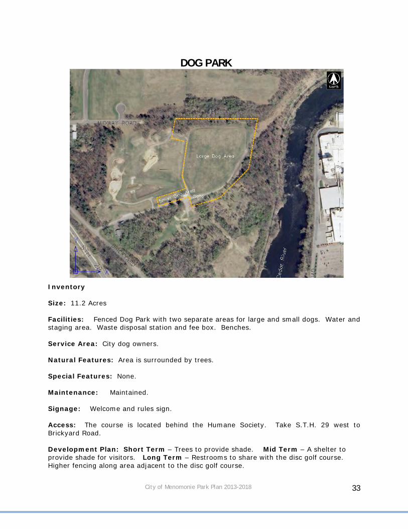
DOG PARK
Inventory Size: 11.2 Acres Facilities: Fenced Dog Park with two separate areas for large and small dogs. Water and staging area. Waste disposal station and fee box. Benches. Service Area: City dog owners. Natural Features: Area is surrounded by trees. Special Features: None. Maintenance: Maintained. Signage: Welcome and rules sign. Access: The course is located behind the Humane Society. Take S.T.H. 29 west to Brickyard Road. Development Plan: Short Term – Trees to provide shade. Mid Term – A shelter to provide shade for visitors. Long Term – Restrooms to share with the disc golf course. Higher fencing along area adjacent to the disc golf course.
City of Menomonie Park Plan 2013-2018 34
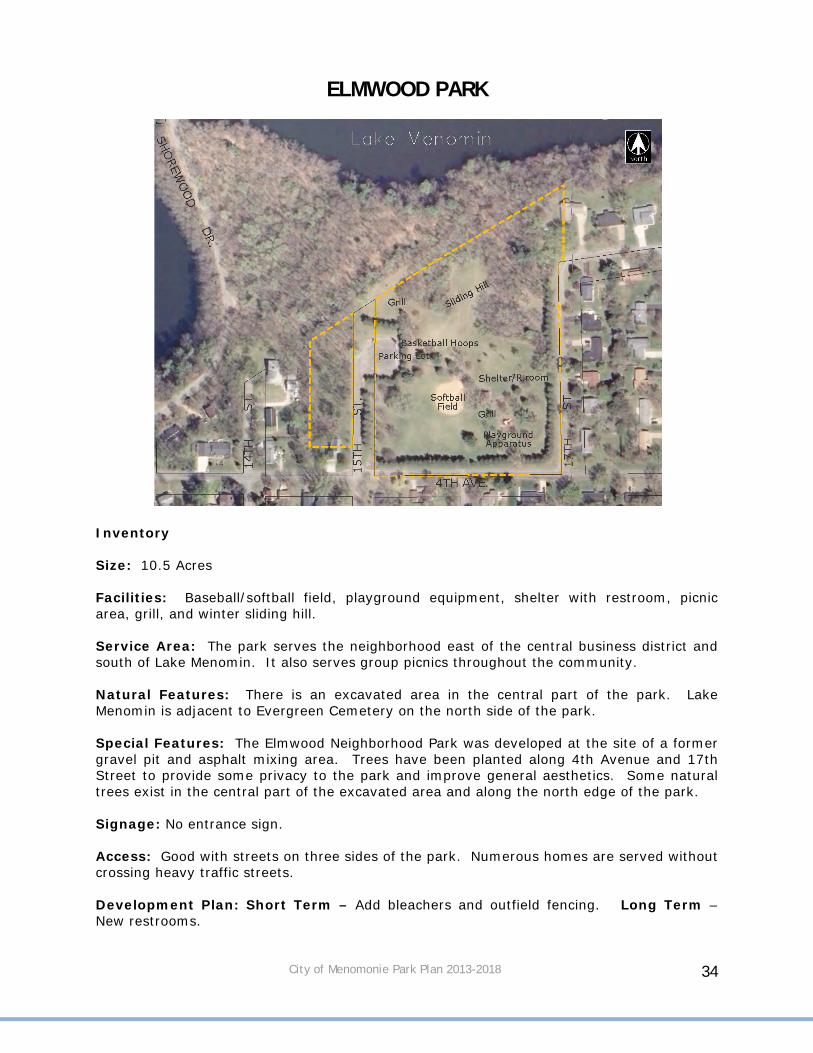
ELMWOOD PARK
Inventory Size: 10.5 Acres Facilities: Baseball/softball field, playground equipment, shelter with restroom, picnic area, grill, and winter sliding hill. Service Area: The park serves the neighborhood east of the central business district and south of Lake Menomin. It also serves group picnics throughout the community. Natural Features: There is an excavated area in the central part of the park. Lake Menomin is adjacent to Evergreen Cemetery on the north side of the park. Special Features: The Elmwood Neighborhood Park was developed at the site of a former gravel pit and asphalt mixing area. Trees have been planted along 4th Avenue and 17th Street to provide some privacy to the park and improve general aesthetics. Some natural trees exist in the central part of the excavated area and along the north edge of the park. Signage: No entrance sign. Access: Good with streets on three sides of the park. Numerous homes are served without crossing heavy traffic streets. Development Plan: Short Term – Add bleachers and outfield fencing. Long Term – New restrooms.
City of Menomonie Park Plan 2013-2018 35
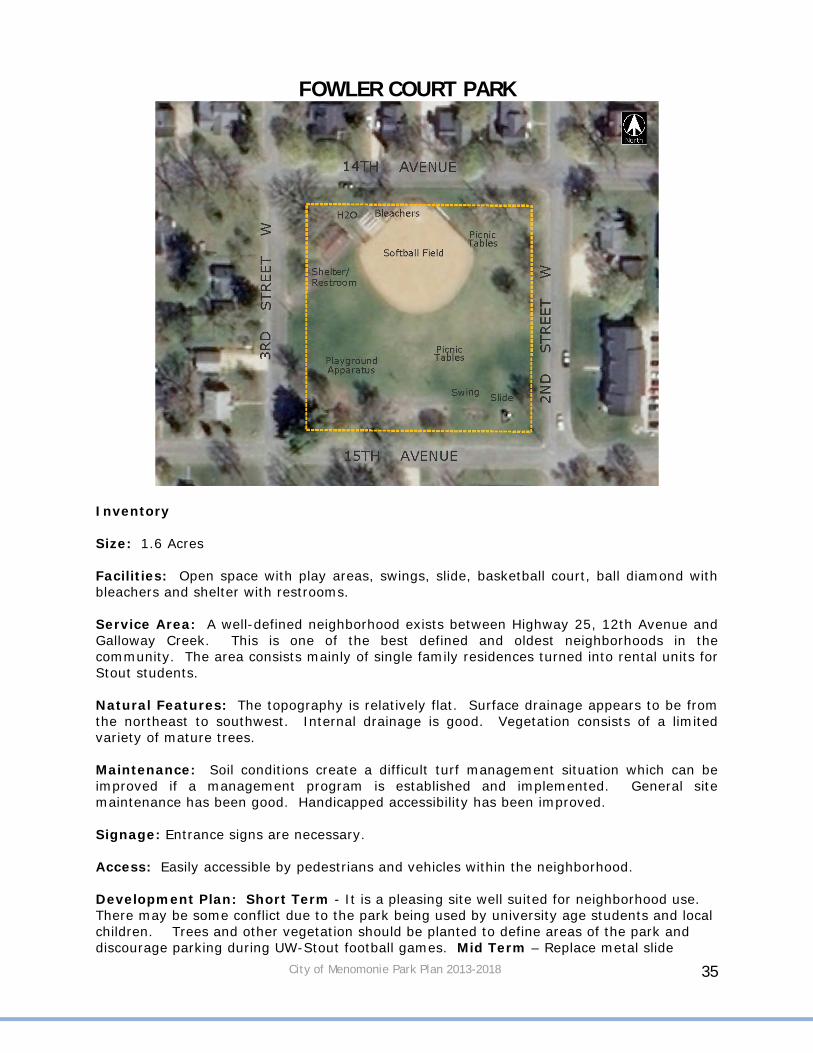
FOWLER COURT PARK
Inventory Size: 1.6 Acres Facilities: Open space with play areas, swings, slide, basketball court, ball diamond with bleachers and shelter with restrooms. Service Area: A well-defined neighborhood exists between Highway 25, 12th Avenue and Galloway Creek. This is one of the best defined and oldest neighborhoods in the community. The area consists mainly of single family residences turned into rental units for Stout students. Natural Features: The topography is relatively flat. Surface drainage appears to be from the northeast to southwest. Internal drainage is good. Vegetation consists of a limited variety of mature trees. Maintenance: Soil conditions create a difficult turf management situation which can be improved if a management program is established and implemented. General site maintenance has been good. Handicapped accessibility has been improved. Signage: Entrance signs are necessary. Access: Easily accessible by pedestrians and vehicles within the neighborhood. Development Plan: Short Term - It is a pleasing site well suited for neighborhood use. There may be some conflict due to the park being used by university age students and local children. Trees and other vegetation should be planted to define areas of the park and discourage parking during UW-Stout football games. Mid Term – Replace metal slide

City of Menomonie Park Plan 2013-2018 36
GALLOWAY CREEK PARK
Inventory Size: 3.4 Acres Facilities: None. Service Area: None Natural Features: Ravine that is heavily wooded. Special Features: None Maintenance: Correct erosion, stabilize banks, improve water flow. Signage: None Development Plan: Leave in a natural state.

City of Menomonie Park Plan 2013-2018 37
LAKESIDE PARK
Inventory Size: 6.9 Acres Facilities: Two boat launches reconstructed in 2007, two docks with one handicap accessible, handicap accessible fishing pier, picnic tables, shelter with restroom that was recently reroofed, black top trails and a large blacktop parking area for vehicles. Signs indicating a “No Mow Zone”. Service Area: The location of this park allows it to be available to all citizens in the community including students from UW-Stout. Natural Features: The park consists of natural lake bank and a fill area where a waste lagoon of a former canning factory exists. The filling of the waste lagoon is complete. The area is approximately 4'-6' above lake level and is relatively flat. Maintenance: Well-maintained. Signage: Existing entrance sign. Development Plan: Almost all amenities, docks, structures, and pavement have been improved over the last three years. Current plans are to maintain as is. Short Term - Rebuild handicap accessible dock. Address parking lot runoff. Mid Term - docks and boat launches will require maintenance or replacement as needed.
City of Menomonie Park Plan 2013-2018 38
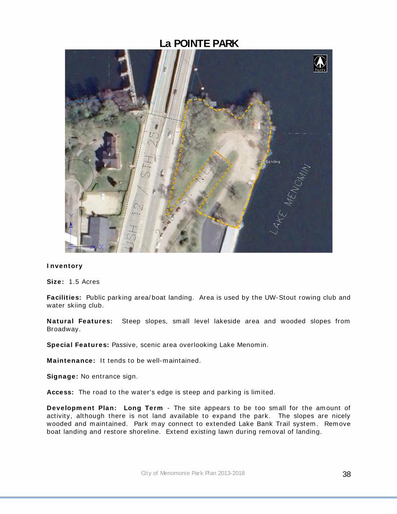
La POINTE PARK
Inventory Size: 1.5 Acres Facilities: Public parking area/boat landing. Area is used by the UW-Stout rowing club and water skiing club. Natural Features: Steep slopes, small level lakeside area and wooded slopes from Broadway. Special Features: Passive, scenic area overlooking Lake Menomin. Maintenance: It tends to be well-maintained. Signage: No entrance sign. Access: The road to the water's edge is steep and parking is limited. Development Plan: Long Term - The site appears to be too small for the amount of activity, although there is not land available to expand the park. The slopes are nicely wooded and maintained. Park may connect to extended Lake Bank Trail system. Remove boat landing and restore shoreline. Extend existing lawn during removal of landing.

City of Menomonie Park Plan 2013-2018 39
LEISURE SERVICES CENTER PARK
Inventory Size: 1.6 Acre Facilities: Small playground consisting of swings, jungle gym, horseshoe pits, a shelter with picnic tables, and a volleyball court. Service Area: This playground has a reasonably well-defined service area within an area served by other recreation facilities--Wilson Park, St. Joseph's, St. Paul's, East and Stout. Natural Features: Drainage appears to present few problems to use and vegetation consists of a few large specimen trees and numerous boulevard trees. Special Features: Large old trees in an established residential neighborhood. Maintenance: Well-maintained. Signage: Entrance signs are necessary. Development Plan: Short Term - Replace the playground equipment. Further development of this park is not anticipated. Additional plantings should be considered.

City of Menomonie Park Plan 2013-2018 40
LION’S GAME FARM
Inventory Size: 26.4 Acres Facilities: Large fenced in area to view animals. Walking trail through the park. Shelter at the entrance to the park. Natural Features: Wooded area with small ponds. Special Features: Elk, deer, and buffalo. Maintenance: Routine maintenance of fencing and buildings. Signage: Existing entrance sign. Access: There is vehicular and pedestrian access through Wakanda Park. Development Plan: The Lion’s Club is responsible for development plans.

City of Menomonie Park Plan 2013-2018 41
MILLER PARK
Inventory Size: 4.2 Acres Facilities: This is open land acquired by the City. Natural Features: Mowed open space with a wooded slope towards residential areas. Some newly planted trees near the roadways. Special Features: None Maintenance: Well maintained. Signage: Existing entrance sign. Access: There is vehicular and pedestrian access along S.T.H. 29 and 3rd and 5th Street West. Development Plan: Basic maintenance should be continued for this open space park.

City of Menomonie Park Plan 2013-2018 42
OAKWOOD PARK
Inventory Size: 0.5 Acres Service Area: Immediate neighborhood Natural Features: Vegetation includes a variety of trees and shrubs such as mountain ash and maple trees. Maintenance: Well-maintained. Signage: No entrance sign. Access: Oakwood Boulevard Development Plan: Basic maintenance should be continued for this open space park.
City of Menomonie Park Plan 2013-2018 43
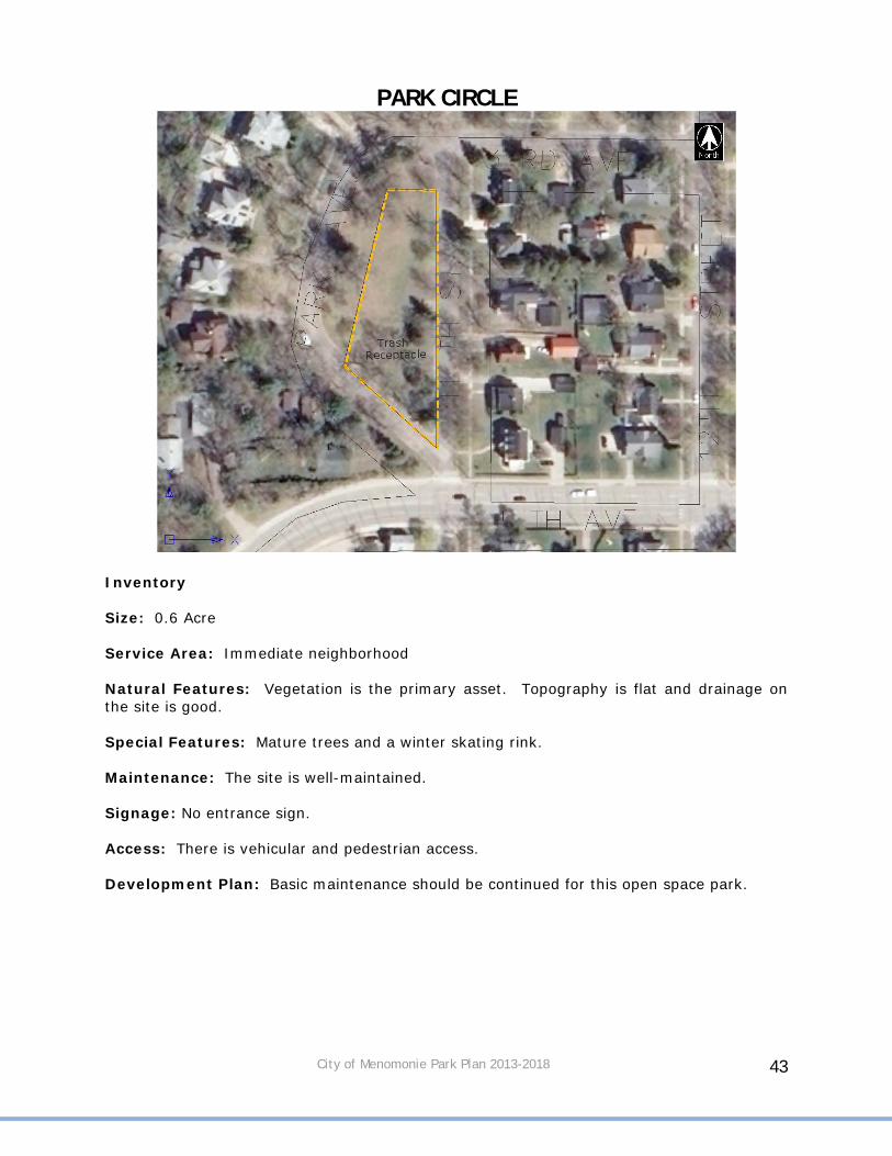
PARK CIRCLE
Inventory Size: 0.6 Acre Service Area: Immediate neighborhood Natural Features: Vegetation is the primary asset. Topography is flat and drainage on the site is good. Special Features: Mature trees and a winter skating rink. Maintenance: The site is well-maintained. Signage: No entrance sign. Access: There is vehicular and pedestrian access. Development Plan: Basic maintenance should be continued for this open space park.

City of Menomonie Park Plan 2013-2018 44
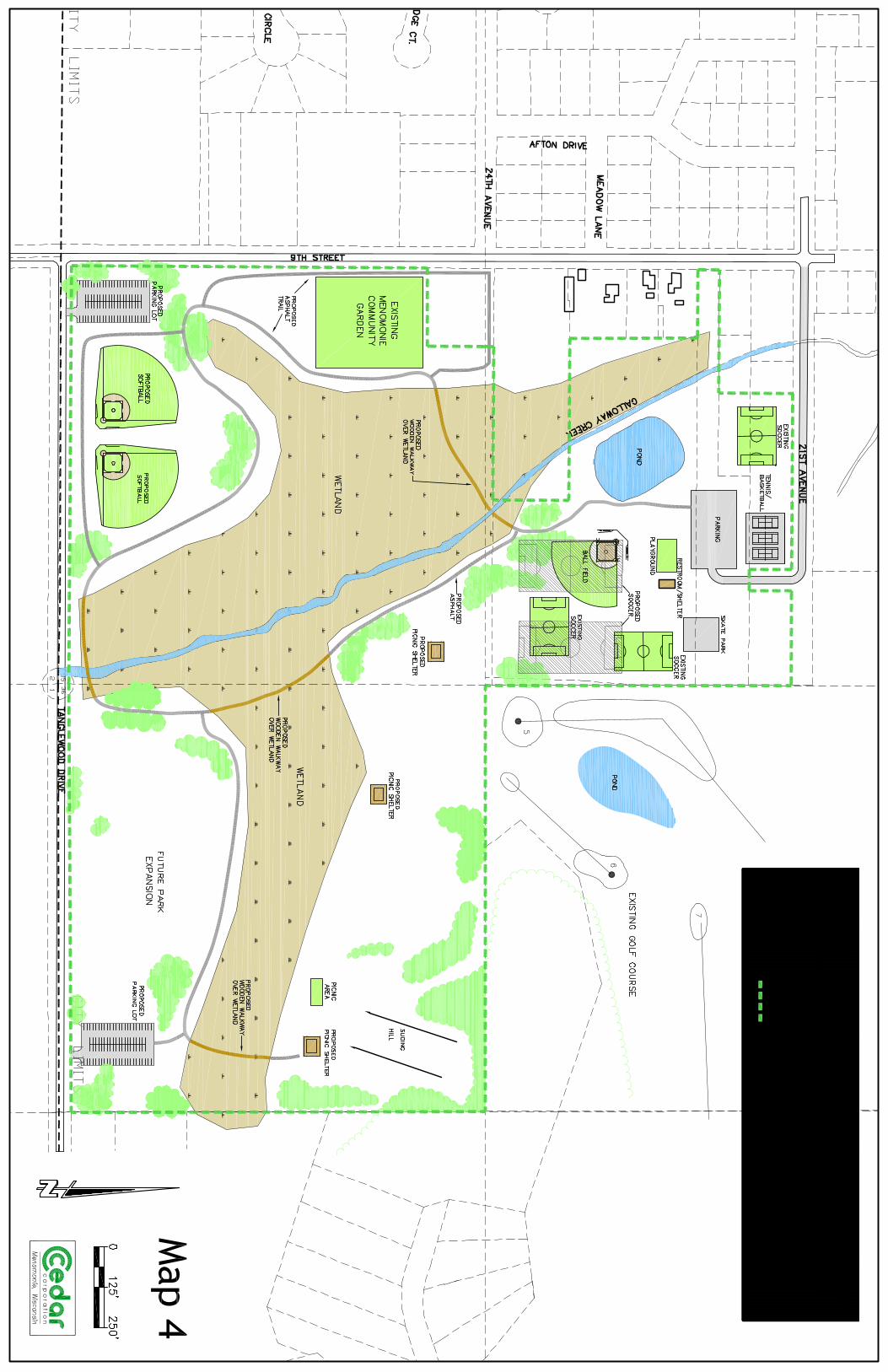
PHELAN PARK
Inventory Size: 97 Acres Facilities: Open play areas, picnic shelter with restrooms, picnic areas, pond, skate park, playground equipment, sidewalk, soccer field, tennis courts, and basketball court. Phelan Park, formerly named Galloway Park, was constructed in 1980 by the City of Menomonie using Community Development Block Grant and local funds. Construction of the park included dredging Galloway Creek, dredging and developing a pond and grading the park site. The City planted numerous small trees throughout the park. Adjacent to the picnic shelter are larger trees. Additional trees and vegetation will be required in the future to upgrade the park. Additional lands to the south were purchased by the City using WisDNR funding. The eastern half of these lands are required to remain passive recreation. Current utilization of the park, including soccer, skating, and flag football activities congregate large numbers of people. The park is also utilized for family picnicking, softball and other activities. In 2010, the Menomonie Community Gardens were added to the park and have an agreement with the city through 2023. Service Area: The park serves the neighborhood east of Broadway Street and south of CTH J. It is also used for community activities including flag football games.

City of Menomonie Park Plan 2013-2018 45
Natural Features: Galloway Creek has been dredged to restore the streambed and a pond was constructed. Signage: Entrance signs are necessary. Access: Park access is from 21st Avenue extended east of 9th Street on the north side of the park. Development Plan: Short Term - Repair fencing around tennis court where heaving has occurred. Additional tree planting to replace large number of ash that may be lost. Repair and upgrade tennis courts. Repair skate park sign. Mid Term – Construct baseball field, reroof shelter, reroof pavilion. Long Term – Construct nature trails through the land acquired to the south to extend around to the existing pond. Benches along the trails along with a picnic shelter would be an added amenity. The southern addition contains many wetland areas. Much of this area should be left in a natural state. Improve water source for Community Gardens.

City of Menomonie Park Plan 2013-2018 47
POINT COMFORT PARK
Inventory Size: 8.9 acres Facilities: Handicap accessible restroom, drinking water, swing, log roll, slide, picnic shelters, picnic tables, fire pits, boat ramps, handicap docks, trails, swimming beach, parking, and shelter. The restroom, fishing pier and two boat launches have been constructed to provide handicap accessibility. A handicap trail has been added from the parking lot to the dock. The Bass Masters built a new pavilion and portions of the playground equipment have been replaced. Service Area: The site is somewhat removed from existing development. The immediate service area (walking distance) includes the adjacent neighborhood. Natural Features: Vegetation covers half the site. Oak and white pine are the dominant species and a variety of trees have been planted. Except for the parking area, turf covers the entire site. Topography of the park is relatively flat. The change in elevation is rapid to the south and east. Special Features: Tall pines and scenic views toward downtown are special assets to the park. Maintenance: This is generally a well-maintained site. Signage: New signs. Access: On-site parking can accommodate boats, trailers and cars.

City of Menomonie Park Plan 2013-2018 48
Development Plan: Short Term – clean up cluttered signage. Mid Term – Replace roofs on shelters and restroom, re-stripe parking areas, and reconstruct boat ramps and docks. Replace remaining original playground equipment.

City of Menomonie Park Plan 2013-2018 49
RIDGEWOOD PARK
Inventory Size: 3.3 Acres Service Area: Immediate neighborhood Natural Features: Area has been graded and seeded. Stormwater pond is on site. Maintenance: Well-maintained. Signage: Entrance sign. Access: Area can be accessed from Wiggins Road. Development Plan: Long Term – Acquire more land to the west as area develops to create a larger park. Expand into a neighborhood playground with possible trails around stormwater pond.
City of Menomonie Park Plan 2013-2018 50
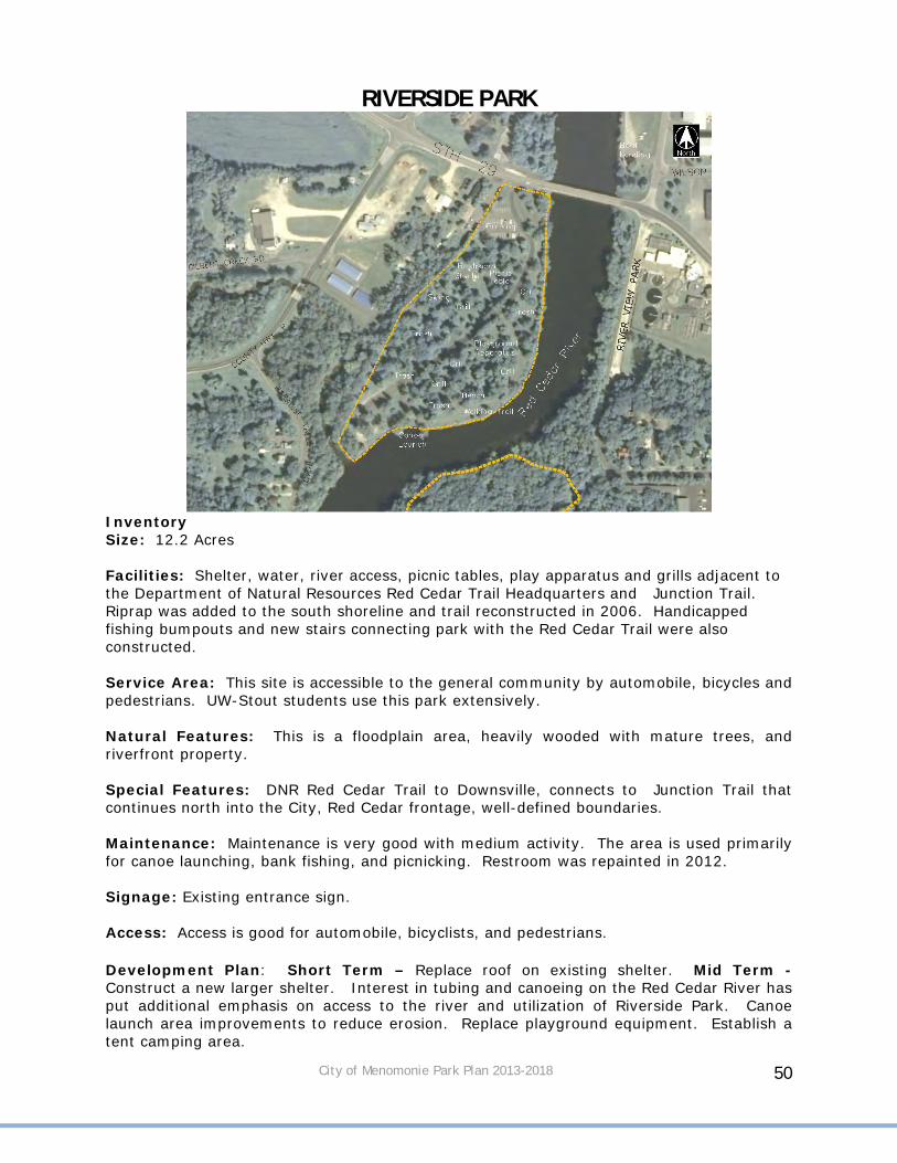
RIVERSIDE PARK
Inventory Size: 12.2 Acres Facilities: Shelter, water, river access, picnic tables, play apparatus and grills adjacent to the Department of Natural Resources Red Cedar Trail Headquarters and Junction Trail. Riprap was added to the south shoreline and trail reconstructed in 2006. Handicapped fishing bumpouts and new stairs connecting park with the Red Cedar Trail were also constructed. Service Area: This site is accessible to the general community by automobile, bicycles and pedestrians. UW-Stout students use this park extensively. Natural Features: This is a floodplain area, heavily wooded with mature trees, and riverfront property. Special Features: DNR Red Cedar Trail to Downsville, connects to Junction Trail that continues north into the City, Red Cedar frontage, well-defined boundaries. Maintenance: Maintenance is very good with medium activity. The area is used primarily for canoe launching, bank fishing, and picnicking. Restroom was repainted in 2012. Signage: Existing entrance sign. Access: Access is good for automobile, bicyclists, and pedestrians. Development Plan: Short Term – Replace roof on existing shelter. Mid Term - Construct a new larger shelter. Interest in tubing and canoeing on the Red Cedar River has put additional emphasis on access to the river and utilization of Riverside Park. Canoe launch area improvements to reduce erosion. Replace playground equipment. Establish a tent camping area.

City of Menomonie Park Plan 2013-2018 51
SANNA PARK
Inventory Size: 8.9 Acres Facilities: Picnic tables, grills and shelter. Service Area: The site services community residents and regional tourist traffic. Natural Features: The principal boundaries are formed by Wilson Creek on the west and Broadway Street on the east. Topography along Wilson Creek is quite severe -- elevation change between the creek bed and the park is in excess of 50 feet. The park land above the creek is rather narrow and heavily wooded. The predominant species are pine, maple and mountain ash. Special Features: High bluff, Wilson Creek, exposed bedrock, large pine and dramatic views across and up Wilson Creek. Maintenance: Bank erosion caused by pedestrian use, uncontrolled movement and parking automobiles have caused problems. The soil is light and heavily shaded by pine trees. Grass is difficult to grow. Signage: No entrance sign. Access: There is vehicular access off North Broadway (Highway 25/12). Pedestrian access is restricted by the high volume of traffic.

City of Menomonie Park Plan 2013-2018 52
Development Plan: Mid Term - The Park is an excellent visual feature when entering into the City. There is no need for expansion, although improvements could be made to enhance the quality. Sanna Park attracts visitors and those who stop for a quick lunch break. Trails should be developed within the park and connect to Wilson Creek acreage. Trees should be replaced in the future, if needed.
City of Menomonie Park Plan 2013-2018 53
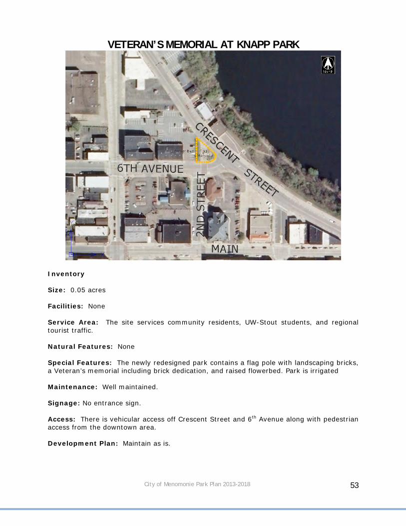
VETERAN’S MEMORIAL AT KNAPP PARK
Inventory Size: 0.05 acres Facilities: None Service Area: The site services community residents, UW-Stout students, and regional tourist traffic. Natural Features: None Special Features: The newly redesigned park contains a flag pole with landscaping bricks, a Veteran’s memorial including brick dedication, and raised flowerbed. Park is irrigated Maintenance: Well maintained. Signage: No entrance sign. Access: There is vehicular access off Crescent Street and 6th Avenue along with pedestrian access from the downtown area. Development Plan: Maintain as is.

City of Menomonie Park Plan 2013-2018 54
WAKANDA PARK
Inventory Size: 90.6 acres Facilities: Baseball, little league and softball diamonds; horseshoe pits ; picnic shelters; park maintenance structure/storage area; concession building; restrooms; miscellaneous play apparatus; picnic tables and charcoal grills; parking; boat launch area; general play area with basketball pad; bleachers; disc golf; drinking fountains and Lions Club rental shelters with facilities. Service Area: This regional park serves Menomonie during the week and the region during the weekend and holidays. Natural Features: A beach is available, although swimming is not recommended until improvements are made. Boundaries are not set for swimming and run-off creates algae in the water. There are steep banks rising 50' behind beach road to the upper level where picnicking and field games are located. Vegetation consists of predominantly oak and pine trees. Oak wilt disease has destroyed some of the trees. The soil is sandy to sandy loam susceptible to erosion and drought. Special Features: Indian mounds, views across the lake and diversity of recreational opportunities. Maintenance: Maintenance is generally excellent. The City has provided some curb and gutter improvements. Signage: There needs to be additional signs directing traffic to the park. The park entrance is not marked.
City of Menomonie Park Plan 2013-2018 55
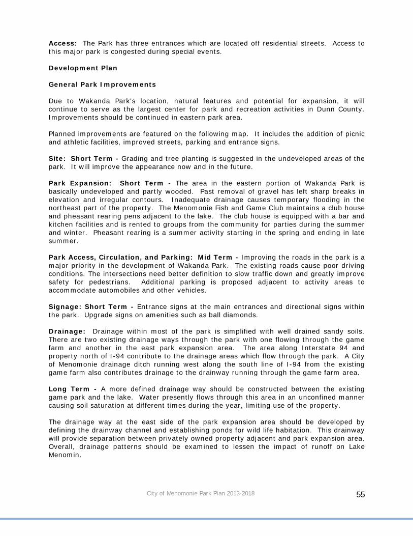
Access: The Park has three entrances which are located off residential streets. Access to this major park is congested during special events. Development Plan General Park Improvements Due to Wakanda Park's location, natural features and potential for expansion, it will continue to serve as the largest center for park and recreation activities in Dunn County. Improvements should be continued in eastern park area. Planned improvements are featured on the following map. It includes the addition of picnic and athletic facilities, improved streets, parking and entrance signs. Site: Short Term - Grading and tree planting is suggested in the undeveloped areas of the park. It will improve the appearance now and in the future. Park Expansion: Short Term - The area in the eastern portion of Wakanda Park is basically undeveloped and partly wooded. Past removal of gravel has left sharp breaks in elevation and irregular contours. Inadequate drainage causes temporary flooding in the northeast part of the property. The Menomonie Fish and Game Club maintains a club house and pheasant rearing pens adjacent to the lake. The club house is equipped with a bar and kitchen facilities and is rented to groups from the community for parties during the summer and winter. Pheasant rearing is a summer activity starting in the spring and ending in late summer. Park Access, Circulation, and Parking: Mid Term - Improving the roads in the park is a major priority in the development of Wakanda Park. The existing roads cause poor driving conditions. The intersections need better definition to slow traffic down and greatly improve safety for pedestrians. Additional parking is proposed adjacent to activity areas to accommodate automobiles and other vehicles. Signage: Short Term - Entrance signs at the main entrances and directional signs within the park. Upgrade signs on amenities such as ball diamonds. Drainage: Drainage within most of the park is simplified with well drained sandy soils. There are two existing drainage ways through the park with one flowing through the game farm and another in the east park expansion area. The area along Interstate 94 and property north of I-94 contribute to the drainage areas which flow through the park. A City of Menomonie drainage ditch running west along the south line of I-94 from the existing game farm also contributes drainage to the drainway running through the game farm area. Long Term - A more defined drainage way should be constructed between the existing game park and the lake. Water presently flows through this area in an unconfined manner causing soil saturation at different times during the year, limiting use of the property. The drainage way at the east side of the park expansion area should be developed by defining the drainway channel and establishing ponds for wild life habitation. This drainway will provide separation between privately owned property adjacent and park expansion area. Overall, drainage patterns should be examined to lessen the impact of runoff on Lake Menomin.

City of Menomonie Park Plan 2013-2018 56
Recreation Area Improvements Football/Soccer/Baseball/Softball, and Batting Cage: Short Term - The area north of the park has been designated for a football/soccer/ball field and batting cages. With a growing interest in football and soccer in the community, better facilities are needed in the future. Space may be provided in the park expansion area for development of two baseball, softball, and soccer fields. The first of those fields was completed in the summer of 2007. The baseball, softball, and soccer fields can be utilized for practice areas and casual play during the summer season when football and soccer are not active. Short Term – Complete ball diamond by the Park Shop. Long Term – New lights and poles on diamond #1. Clean up brush on hillside and add woodchips to help find foul balls. Relocate bullpen area and improve turf. New lights by diamonds #4 and #5. Tennis: Long Term - It is recommended that two groups of three courts be included in the long-range development of Wakanda Park. One group of tennis courts is proposed adjacent to the large group picnic area where it could be utilized by picnic groups as well as other park users. The City of Menomonie does not offer tennis courts for residential use at Wakanda Park. The Phelan Park, Menomonie School District, and UW-Stout have courts which are utilized by students during the school year and are available for public use during the summer season. Participation in the Menomonie Recreation Department's Tennis Program and casual play by local citizens has continuously increased with the development of additional facilities. Horseshoes: Short-Term – The park presently includes a horseshoe pit grouping adjacent to the maintenance building. The horseshoe pits should continue to exist. Volleyball Courts: Long Term - The park does not have permanent volleyball courts. Since the game is becoming increasingly popular, sand based volleyball courts are proposed in the beach area as well as ag-lime courts. Playground Areas: The playground at Wakanda Park is equipped to provide a variety of playing experiences for children. The playground equipment includes a spiral slide, merry-go-round, straight slides, basketball pad, and swing sets. Recently, additional playground equipment has been installed and benches have been added. The Water Park was painted and a stump slide was installed. Wakanda Water Park: Mid Term – A lazy river could be added around the perimeter of the water park. Also, a splash pad could be added and the playground equipment with sand removed. Wakanda Water Park attracts users throughout western Wisconsin. Currently, there are no other water parks in the area that compete with Wakanda. Further additions to the park should be discussed to ensure the park remains an attraction. Beach Area: Short Term – Lights at the top and bottom of the stairs leading from the upper portion of the park down to the beach area. Lights along the road adjacent to the beach area. Mid Term - Restrooms and a water spigot in the open space near the beach.

City of Menomonie Park Plan 2013-2018 57
The beach area is an integral part of the total park concept and is utilized by families picnicking, boating, and using other park facilities. The beach is used for sunbathing. Few people actually swim from the beach because of water quality issues. Restroom/Concession Facilities: Mid Term – Improve foul ball protection near the concession stand. Long Term – Replace concession stand near the lighted Menomonie Area Youth Baseball Association (MAYBA) field. Construct a new centrally located pavilion with a concession area and restrooms. Frisbee Golf Course: Short Term – New hole signs that indicate par and length of hole. Picnic Shelters: Long Term - Replace old roofs on pavilions with new green metal roofs. Locations with a lake view claim a high priority and are very desirable for picnic use. The plan includes development of picnic areas adjacent to the lakeshore in the proposed park expansion area and in a presently undeveloped area south of the Game Park. Existing picnic areas in Wakanda Park are heavily used. Local residents find it necessary to reserve tables and shelters early in the morning on weekends to use them during the day. The Dunn County Recreation Plan indicates a substantial need for additional picnic facilities in Dunn County. Due to Menomonie's central location and high concentration of population in the county, there is an identifiable need for further development of picnic facilities, fire pits and other facilities to accommodate family or large group picnics. Wakanda Park would be an excellent location for this. The existing restroom facilities accommodate group picnics adequately. Relocation of existing park roads will provide larger areas adjacent to the lake and minimize the conflict between vehicles and pedestrians using the park. Currently, the Lion’s Club rents shelters with kitchens and restrooms. Trails: Long Term - A walking/skiing trail is proposed to be constructed from the beach to the boat landing. A looped trail should also be constructed to and from the Indian mounds. Boat Landing: Mid Term – Reconstruct boat landing and docks. Park Entrance from Pine Street: Long Term - Enhance main entrance to the park through landscaping, signage, or an arch. Winter Activities: The City of Menomonie has experienced substantial interest and participation in summer activities in the community where adequate facilities are available. There has been a lack of facilities for winter recreation. Consideration should be given to the development of ice skating and cross-country skiing in Wakanda Park. The present road to the beach areas is utilized for sliding purposes during the winter and is closed to traffic. The development of winterized restrooms should be considered if potential for expanded winter activities is possible within the park area.
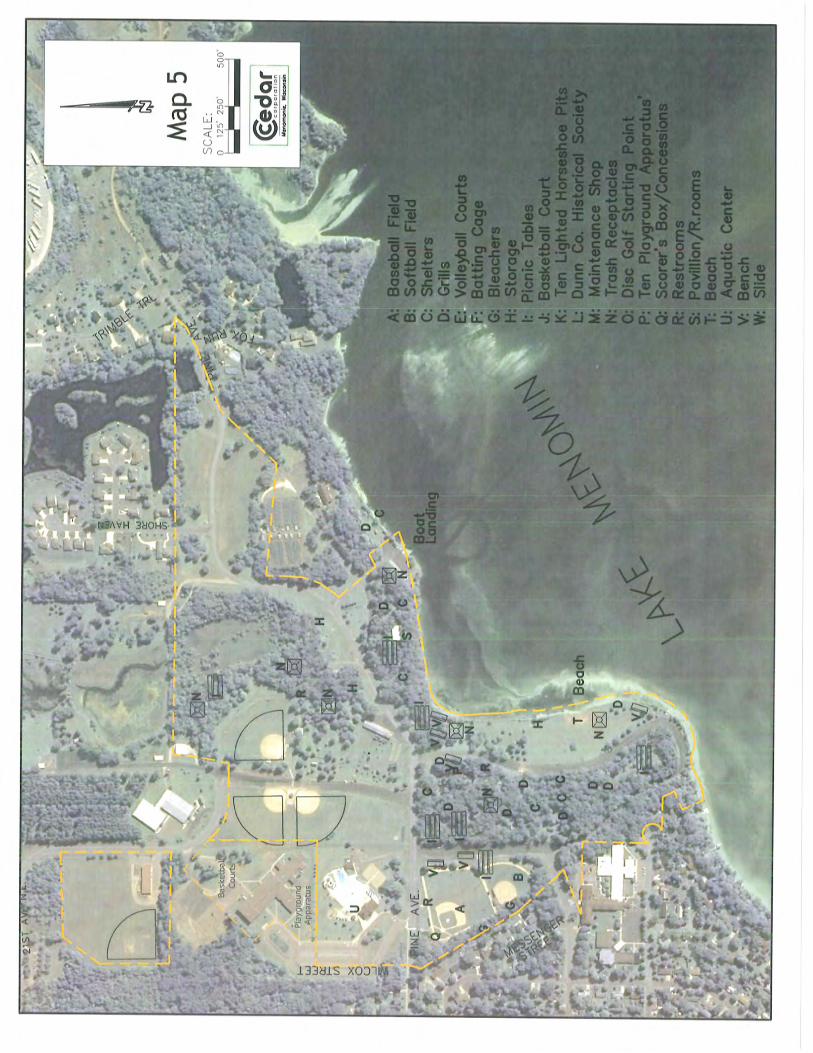


City of Menomonie Park Plan 2013-2018 60
WHISPER RIDGE PARK
Inventory Size: 2.3 Acres Facilities: Children’s playground equipment, tennis/basketball court, and picnic shelter. Service Area: Whisper Ridge Park is a private park serving the Whisper Ridge subdivision. Natural Features: Topography is flat and adjacent to wetlands and open space. Signage: No entrance signs. Access: The site is easily accessible from a sidewalk on Nicholas Drive. Development Plan: Park area will be further developed as the subdivision grows.

City of Menomonie Park Plan 2013-2018 61
WILSON PARK
Inventory Size: 1.6 Acres Facilities: Band shell, benches, picnic shelter, and picnic tables. Service Area: Immediate neighborhood for day use plus visitors who may be in the neighborhood for other purposes. The service area increases when there is a concert at the band shell. Wilson Park is heavily used by church school, church groups, private school groups and other neighborhood organizations Natural Features: Topography is flat. Vegetation is mixed consisting of catalpa, green ash, white pine, oak, elm, and shrub varieties. Maples have been used in replacement planting along the edges. Special Features: Band shell. This facility is used on Tuesday evenings during the summer months for a free community band concert. Other activities could include dramatic productions, children’s theater (day), concerts and weddings. The proximity of the park to business, commercial, government, university and residential land use increases its exposure and use potential. Maintenance: The park is well maintained. Signage: No entrance signs.
City of Menomonie Park Plan 2013-2018 62
Access: The site is easily accessible from any direction for vehicles and pedestrians. Development Plan: Continue to add improvements along the Victorian theme. Add additional trees to replace ash if they need removal. Short Term – Tuck point planters on both sides of the band shelter. Relocate sculpture. Landscaping improvements/plantings around the band shell. Acreage expansion is not possible or necessary, although the facilities could be expanded. Restrooms have been recently remodeled. The picnic shelter and band shell should be upgraded. Work should be done on restoring quality turf in the park. There is an interesting variety of plant material, texture, color, flower and fruit. This theme should be expanded and developed as a passive recreation site. A loss of trees by elm disease has resulted in substantial loss of park atmosphere and aesthetic value. Tree planting, using large trees installed by a tree mover, planting of other trees and vegetation to restore the quality of the park should be undertaken. Recycling containers could be added. Long Term – Replace the roof membrane on the band shell.

City of Menomonie Park Plan 2013-2018 63
WILSON CREEK PARK
Inventory Size: 52.7 acres of creek bank (5 acres accessible along creek). Natural Features: Natural vegetation and steep slopes typify Wilson Creek. Signage: No entrance sign. Development Plan: Long Term - Constructing a walking trail that will connect with Sanna Park. Limited development is anticipated to maintain quality of the lakeshore.

City of Menomonie Park Plan 2013-2018 64
WOLSKE BAY PARK
Inventory Size: 2.9 Acres Facilities: The Park includes two shelters with electricity, tables, grills, benches, paved parking lot, and handicapped accessible trail. A handicapped accessible fishing pier was added in the spring of 2007. There is a usable concrete slab remaining after a building was removed. Service Area: Location allows access for all citizens. Natural Features: Lake Menomin, bays, and reestablished shoreline. Maintenance: Well maintained. Signage: No entrance sign. Development Plan: Mid Term – Add restrooms. Long Term - Construct trail connecting Wolske Bay Park to Lakeside Park if feasible. Continue to address water quality and circulation issues. Dredge bay to assist with water quality.

City of Menomonie Park Plan 2013-2018 65
DUNN COUNTY RECREATION PARK
Inventory Size: 53.8 Acres Facilities: Parking, restrooms year-round, picnic area, track, grandstand, arena (ice hockey) exhibition buildings, lighted ball fields, Dunn County Snowpark, Farmers Market, water and electricity. This park is owned, operated, and maintained by Dunn County. Service Area: Dunn County Recreation Park services the region at fair time and special events other times of the year. The community uses the park for local events and recreation activities. Natural Features: These include sandy soils that are reasonably well-drained and high hills on the south end of the site. These hills are heavily wooded in certain areas. Very little use has been made of the south entry road that defines the midway area at fair time. As the snow melts in the spring, it creates problems. The sandy soils absorb a great deal of water rapidly, but the flatness of the site near the arena area has created water problems. Special Features: Ice arena, grandstand, track and other exhibition structures. Maintenance: There is intense use for short periods of time. Roads as well as parking areas need to be defined. Signage: No entrance sign.

City of Menomonie Park Plan 2013-2018 66
Access: Main Street entrance is well-defined. Development Plan: Dunn County is responsible for the development plan. Internal reorganization would result in improved circulation and space utilization. The site should be programmed for more use. On-site circulation and space use needs to be redefined. Future use plans should be developed in cooperation with the City, Menomonie School District and UW-Stout.

City of Menomonie Park Plan 2013-2018 67
MENOMIN PARK
Inventory Size: 151.6 Acres Facilities: Shelter and trail. Service Area: It services the entire community. The park is owned by Dunn County. Natural Features: Topography varies on the site from approximately 814' to 858' in elevation. Lake Menomin forms the west boundary. Approximately 80 percent of the site is at an elevation of 830' or lower. Good site definition is created by topography to the north and east. A large portion of the site has been used for agricultural purposes; other portions are low and wet. The north and east edge is heavily wooded, native and planted species. Soils are light and subject to erosion. Small ponds are also located on the site, creating added interest. Special Features: The site has unique character and vegetation. The ponds and prairie grass are also interesting features. Mountain bike trails and a pump track have been developed by the Menomonie Area Mountain Bike Association (MAMBA). MAMBA recently created a brochure highlighting the various trails in the Park. Maintenance: Soil conditions will create the most serious problems-- erosion, medium for plants, waste disposal and intense use. Signage: No entrance signs.

City of Menomonie Park Plan 2013-2018 68
Access: Via Red Cedar Street and Domain Drive. Topography and adjacent land uses will limit access potential. Development Plan: Dunn County is responsible for the development plan. This is an excellent site to be developed for extensive use by the community. Land should be retained in reserve until it is needed. Restrooms, a playground, baseball/softball fields and lights could be added near the entrance to the park.
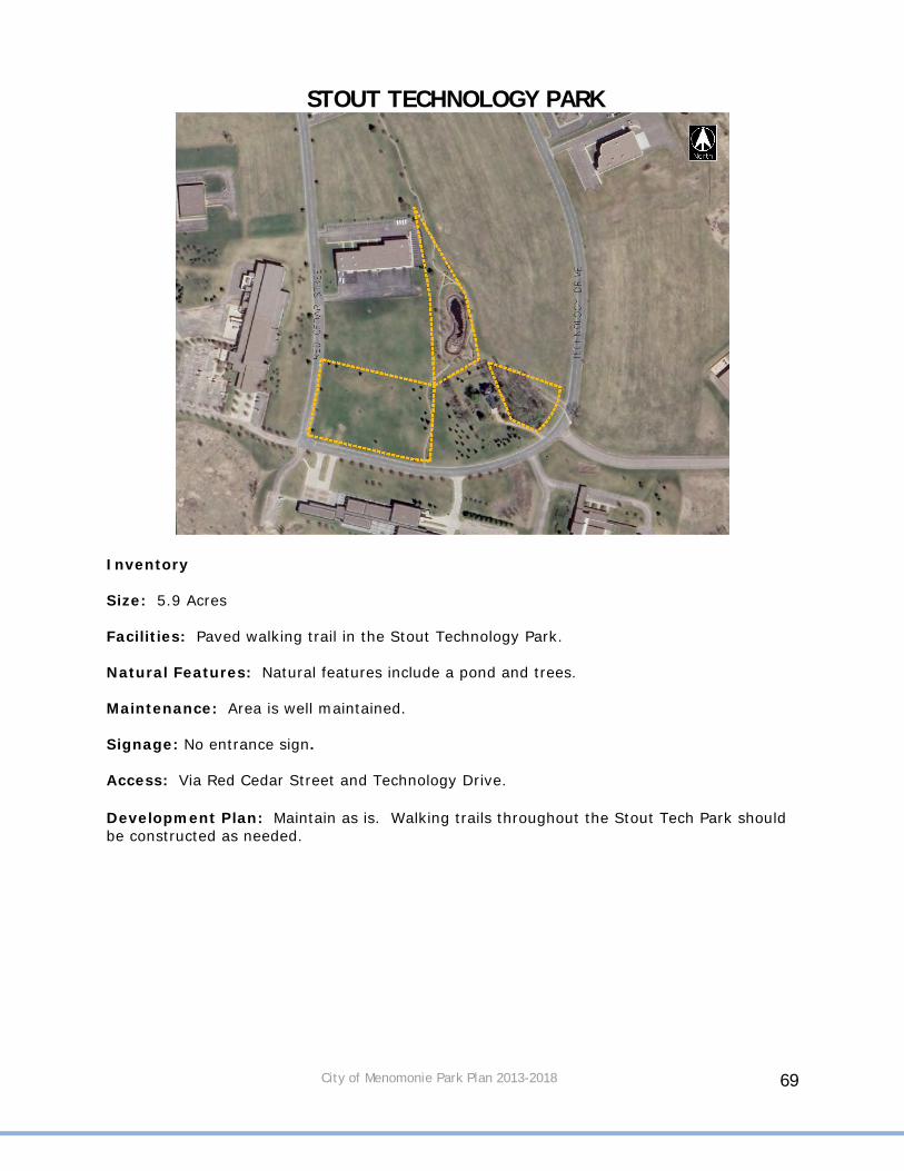
City of Menomonie Park Plan 2013-2018 69
STOUT TECHNOLOGY PARK
Inventory Size: 5.9 Acres Facilities: Paved walking trail in the Stout Technology Park. Natural Features: Natural features include a pond and trees. Maintenance: Area is well maintained. Signage: No entrance sign. Access: Via Red Cedar Street and Technology Drive. Development Plan: Maintain as is. Walking trails throughout the Stout Tech Park should be constructed as needed.

City of Menomonie Park Plan 2013-2018 70
JUNCTION TRAIL
Inventory Site: 11,100’ in length. Facilities: The Junction Trail is located on Hwy 29 at the DNR headquarters. It connects to the Red Cedar Trail and extends up the river and across S.T.H 25/Broadway and follows an old railroad bed up to Oak Avenue. The trail is paved and some areas will have benches. Natural Features: Wooded banks that follow the Red Cedar River and other wooded areas along the trail. Special Features: View of the Red Cedar River and Lake Menomin. Maintenance: Area is well maintained. Signage: No entrance sign. Access: Near the DNR office on S.T.H. 29 or USH 12/STH 25 and along the route. Development Plan: Short Term - The trail in north Menomonie will be paved the summer of 2007 and will be maintained by the City and used by pedestrians and non-motorized vehicles. Mid Term - Improve the intersection at STH 25. Signage, landscaping, and delineated crosswalks are planned. The trail could also use the Meadow Hill Railroad Bridge as a trail route instead of street access. Long Term – Route trail under the bridge or highway to avoid the busy intersection at North Broadway/S.T.H. 25. Along the course of this trail is the option to travel east on Maple Avenue to Wakanda Park.

City of Menomonie Park Plan 2013-2018 71
LAKEBANK NATURE TRAIL
Inventory Size: 1,500’ in length. Facilities: Large wooden staircase and gravel walking trail along the southern bank of Lake Menomin. Benches. Informational signs. Original trail was developed almost 100 years ago but was lost when the dam raised the water level on Lake Menomin. The trail was rededicated in 2006. A trailhead with signage, rain gardens, and flower beds was also created. Natural Features: Steep wooded banks and Lake Menomin. Special Features: Staircase and view of Lake Menomin. Maintenance: Area needs upkeep and trimming. . Signage: Two historic nodes define the trailhead. Access: West end of Cedar-Rama Park next to Well #3. Development Plan: Mid Term – Extend trail to the east with a staircase extending up to Crescent Street possibly by the overlook deck. Extend trail to the west and north to connect to La Pointe Park.
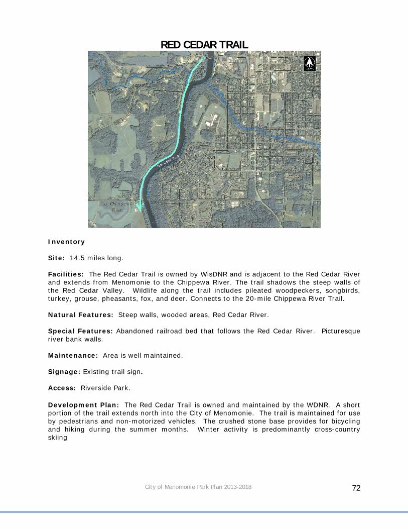
City of Menomonie Park Plan 2013-2018 72
RED CEDAR TRAIL
Inventory Site: 14.5 miles long. Facilities: The Red Cedar Trail is owned by WisDNR and is adjacent to the Red Cedar River and extends from Menomonie to the Chippewa River. The trail shadows the steep walls of the Red Cedar Valley. Wildlife along the trail includes pileated woodpeckers, songbirds, turkey, grouse, pheasants, fox, and deer. Connects to the 20-mile Chippewa River Trail. Natural Features: Steep walls, wooded areas, Red Cedar River. Special Features: Abandoned railroad bed that follows the Red Cedar River. Picturesque river bank walls. Maintenance: Area is well maintained. Signage: Existing trail sign. Access: Riverside Park. Development Plan: The Red Cedar Trail is owned and maintained by the WDNR. A short portion of the trail extends north into the City of Menomonie. The trail is maintained for use by pedestrians and non-motorized vehicles. The crushed stone base provides for bicycling and hiking during the summer months. Winter activity is predominantly cross-country skiing

City of Menomonie Park Plan 2013-2018 73
2ND STREET HISTORIC CORRIDOR
Inventory Site: 1,300 in length. Facilities: Historic walking and biking corridor that travels through the historic downtown and UW-Stout campus. It is mainly used by UW-Stout students and people visiting downtown businesses. Natural Features: Trees along corridor in the City and on University property. Special Features: Historic buildings. Historic nodes along route. Veteran’s Memorial is located on the north end. Landscaping and plantings along corridor. Maintenance: Area is well maintained. Signage: No entrance sign. Access: On 2nd Street in the downtown area. Development Plan: Maintain as is.

City of Menomonie Park Plan 2013-2018 74
MENOMONIE ALLIANCE CHRISTIAN SCHOOL
Inventory Size: 10.9 Acres Facilities: Basketball courts, playground equipment, swings, and a volleyball court.

City of Menomonie Park Plan 2013-2018 75
MENOMONIE MIDDLE SCHOOL
Inventory Size: 40 Acres Facilities: Football field, track, softball field, open space for additional field games, basketball courts, school building--restroom, lockers, water and telephone.

City of Menomonie Park Plan 2013-2018 76
MENOMONIE SENIOR HIGH SCHOOL
Inventory Size: 90 Acres (10 acres developed) Facilities: Eight tennis courts, football field, track, softball field, open space for additional field games, school building--restroom, lockers, water and telephone. Service Area: General area to include the southern half of the City, especially the south-southwest corner. Natural Features: Topography divides the site into the upper fields (practice, softball and tennis) and the lower fields (football, track and baseball). The site is bounded on the north by Galloway Creek and the west by the Red Cedar River. The are adjacent to both waterways is heavily wooded. Special Features: The proximity to the Red Cedar, the wooded banks and vast open areas. A landform resembling a drumlin is located on the south end of the property. Maintenance: Generally good. Sandy soil does create management concerns. Access: Pedestrian access limited to the Fowler neighborhood and River Heights neighborhood. Vehicular access to the site form the general community is good. Development Plans: The School District will prepare a development plan. The large site affords the opportunity to program additional activities. Expansion would be internal. The site needs space definition that could be created by planting and/or earth shaping.
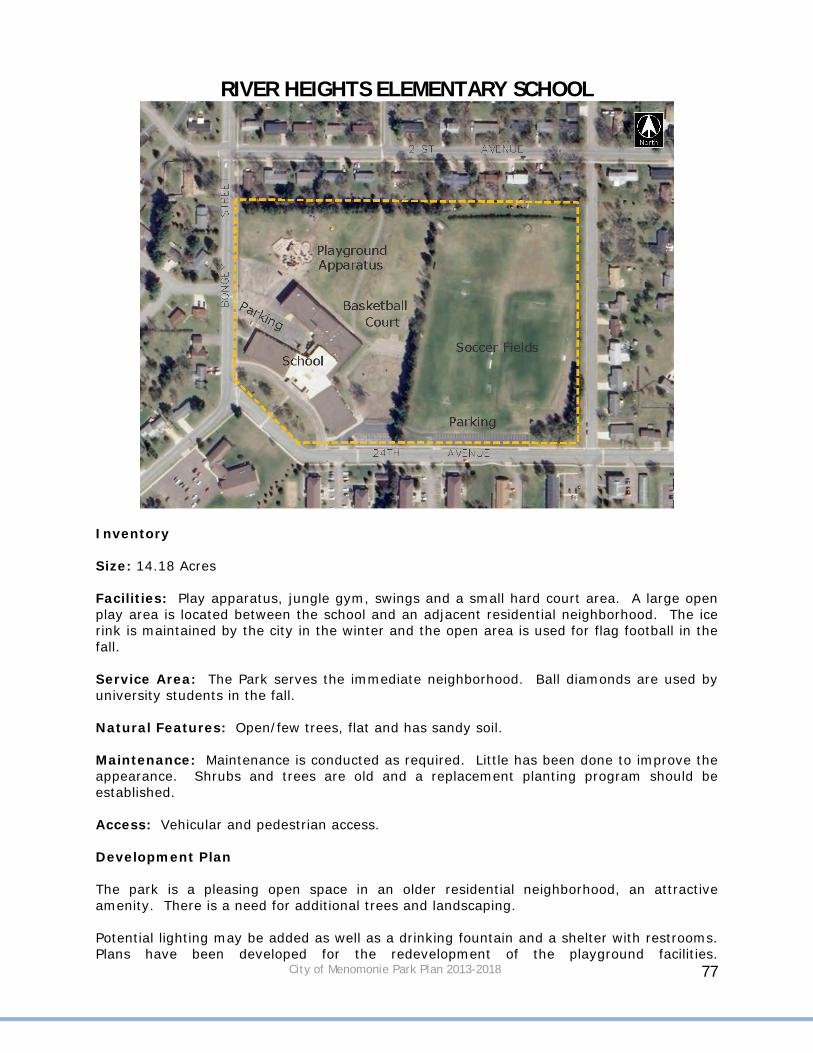
City of Menomonie Park Plan 2013-2018 77
RIVER HEIGHTS ELEMENTARY SCHOOL
Inventory Size: 14.18 Acres Facilities: Play apparatus, jungle gym, swings and a small hard court area. A large open play area is located between the school and an adjacent residential neighborhood. The ice rink is maintained by the city in the winter and the open area is used for flag football in the fall. Service Area: The Park serves the immediate neighborhood. Ball diamonds are used by university students in the fall. Natural Features: Open/few trees, flat and has sandy soil. Maintenance: Maintenance is conducted as required. Little has been done to improve the appearance. Shrubs and trees are old and a replacement planting program should be established. Access: Vehicular and pedestrian access. Development Plan The park is a pleasing open space in an older residential neighborhood, an attractive amenity. There is a need for additional trees and landscaping. Potential lighting may be added as well as a drinking fountain and a shelter with restrooms. Plans have been developed for the redevelopment of the playground facilities.

City of Menomonie Park Plan 2013-2018 78
ST. JOSEPH'S SCHOOL
Inventory Size: 0.5 Acres Facilities: It is a very limited area with new playground equipment. It is not adequate for normal school open space. Two basketball hoops and a large hard court surface.

City of Menomonie Park Plan 2013-2018 79
ST. PAUL'S SCHOOL
Inventory Size: 0.1 Acre Facilities: It is a very limited area with some playground equipment and is not adequate for normal school open space. Some playground equipment and a small basketball court.

City of Menomonie Park Plan 2013-2018 80
OAKLAWN ELEMENTARY SCHOOL
Inventory Size: 19 Acres Facilities: Playground equipment, softball/baseball fields, football/soccer field and ice rink in the winter.

City of Menomonie Park Plan 2013-2018 81
WAKANDA ELEMENTARY SCHOOL
Inventory Size: 2.0 Acres Facilities: Two separate playground areas and three basketball courts.

City of Menomonie Park Plan 2013-2018 82
UW-STOUT SPORTS COMPLEX
Inventory Size: 12.8 Acres Facilities: Ten lighted tennis courts, competitive field games, basketball, locker and gymnasium facilities, parking, lighting and water fountains. Service Area: This is predominantly a UW-Stout community resource. It is not programmed for general community participation. Natural Features: Steep banks on the east side and 3rd Street define the site. Steep slopes are wooded and create a natural buffer between Stout and the adjacent neighborhood. Mature street trees have been retained where possible. The slopes are mixed with deciduous shrubs and trees. Maintenance: Generally good--University staff. Access: Good--adequate parking. Development Plan: This Park should expand as required by University programs. A joint summer program between the University and the City would appear advantageous.

City of Menomonie Park Plan 2013-2018 83
SIGN STANDARDIZATION Entrance signs to parks range from small wooden signs, monuments, former bridge trestles, or no signs at all. Park signs should be standardized in order to make them easily identifiable to residents. New park signs should incorporate three elements in their design:
1. A logo for City parks. 2. The name of each park. 3. Park hours and rules.
Adding park hours and rules would eliminate the need for many smaller signs that can be found in some parks. GENERAL IMPROVEMENTS FOR ALL PARKS Certain improvements in all City parks should be made, along with park signs, to help make them consistent with each other and provide a uniform look.
1. Replace roofs on park shelters. Currently, many have galvanized metal roofs in need of repair. The Parks and Recreation Department has been replacing them with green metal roofs that blend in better with the surrounding.
2. Replace trash receptacles in parks. Most parks have 55 gallon metal drums for trash. Receptacles should be replaced with decorative receptacles similar to the ones in Cedar-Rama Park.
3. Curb in parking areas. Most parks have parking delineated by wooden posts that need regular painting. Some of the posts are damaged each year by snow plowing or vehicles hitting them. Installing curb during road reconstruction will help better delineate parking areas and create a distinct edge between parking and the park areas.
4. Install bicycle racks in parks that have playground equipment, ball fields, trials, etc.
5. Inspect each park to determine if they are ADA compliant. PRIORITIES The proposed improvements in the development plan were placed into three groups:
1. Short Term: To be implemented in the next 1-2 years. 2. Mid Term: To be implemented in the next 3-5 years. 3. Long Term: To be implemented in the next 6-10 years.
Table 12, 13, and 14 show the proposed improvements based on recommended time frame. The priorities should be reviewed and updated each year.

City of Menomonie Park Plan 2013-2018 84
Table 12 – Short Term Priorities
Park Name Proposed Improvements Date Completed
Fowler Court Trees and other vegetation should be planted to define areas of the park.
Leisure Services Center
Replace the playground equipment. Additional plantings should be considered.
Phelan Park Repair fencing around tennis court where heaving has occurred.
Riverside Park New shelter. Wakanda Park Grading and tree planting in the undeveloped
areas of the park north of the maintenance shop.
Wakanda Park Entrance signs at the main entrances and directional signs within the park. Upgrade signs at amenities such as the ball diamonds.
Wakanda Park New ball diamonds behind the maintenance shop. Wakanda Park New lighting by the horseshoe pits. Wakanda Park Lights at the top and bottom of the stairs leading
from the upper portion of the park down to the beach area. Lights along the road adjacent to the beach area.
Wakanda Park New hole signs that indicate par and length of hole on disc course.
Wilson Park Tuck point planters on both sides of the band shelter. Relocate sculpture. Landscaping improvements.
Table 13 – Mid Term Priorities
Park Name Proposed Improvements Date Completed
Bongey Conservancy Area
The open space should be developed as a passive park. Grading of the area to level it out and replanting of grass is recommended. A sidewalk or trail will connect 440th Street and Timber Terrace. A variety of trees along will benches will be placed along the trail. The open space will create a nice buffer between apartment complexes.
Proposed Dog Park A shelter to provide shade for visitors, Cedar-Rama Extend the Lakebank Nature Trail in an easterly
direction and build stairs up to Crescent Street.
Point Comfort Park Replace roofs on shelters, re-stripe parking areas, and reconstruct boat ramps.
Riverside Park Improvements at the canoe launch area to reduce erosion. Replace playground equipment.
Sanna Park Reconstruction of road and parking areas should also take place. Put in new restrooms. Replace roof on shelter. New trash receptacles.
Wakanda Park Improve the roads, parking

City of Menomonie Park Plan 2013-2018 85
Wakanda Park A lazy river should be added around the perimeter of the water park.
Wakanda Park Restrooms and a water spigot in the open space near the beach.
Wakanda Park Reconstruct boat landing. Lakebank Nature Trail Extend trail to the east with a staircase extending
up to Crescent Street possibly by the overlook deck. Extend trail to the west and north to connect to La Pointe Park.
Lakeside Park Maintain docks and boat launches. Wolske Bay Restrooms. Junction Trail Improve the intersection at STH 25. Signage,
landscaping, The trail could also use the Meadow Hill Railroad Bridge as a trail route instead of street access.
Table 14 – Long Term Priorities
Park Name Proposed Improvements Date Completed
Proposed Dog Park Restrooms. Elmwood Park New restrooms. LaPointe Park Remove boat landing and restore shoreline.
Extend existing lawn during removal of landing.
Ridgewood Park Acquire more land to the west as area develops to create on larger park. Develop into a neighborhood playground with possible trails around stormwater pond.
Phelan Park Construct nature trails though the recently acquired land to the south and continue around to the existing pond. Benches along the trails along with a picnic shelter.
Wakanda Park New lights and poles on diamond #1. New lights by diamonds #4 and #5.
Wakanda Park Tennis Courts. Wakanda Park Volleyball Courts. Wakanda Park Replace concession stand near the lighted
Menomonie Area Youth Baseball Association (MAYBA) field. Construct a new centrally located pavilion with a concession area and restrooms.
Wakanda Park Replace older roofs on pavilions with new green metal roofs.
Wakanda Park Development of picnic areas adjacent to the lakeshore in the proposed park expansion area.
Wakanda Park Enhance main entrance to the park through landscaping, signage, or an arch.
Wilson Creek Park Construct a walking trail that will connect with Sanna Park.
Wilson Creek Park
Wolske Bay Park
Construct trail connecting Wolske Bay Park to Lakeside Park if feasible. Continue to address water quality and circulation issues.
Wolske Bay Park
City of Menomonie Park Plan 2013-2018 86
Junction Trail Route trail under the bridge or the highway to avoid the busy intersection at North Broadway/S.T.H. 25.
North Menomonie Bicycle Corridor/Stokke Trail
ONGOING PLAN RECOMMENDATIONS
1. City park facilities should be upgraded by landscaping, including tree and
shrub planting annually to improve the visual quality of the park system. 2. Consideration should be given to expanding the park system to include
more neighborhood parks. 3. The park land dedication ordinance should be reviewed as necessary to
assure that it is adequately providing for park land acquisition and/or development in the areas which are newly subdivided.
4. Consideration should be given to the needs of the physically and mentally
handicapped in the future development of parks in the City. 5. An effort should be made to involve citizens in the park planning process. 6. An effort should be made to continue the involvement of the City
Recreation and Parks Department and service organizations in the park planning process.
7. The City should investigate and take advantage of state and federal
financial aid programs for park land acquisition and development.
8. The City should place park land acquisition and development plans in priority and utilize a capital improvements program to implement its plan.
9. The City should continue its good working relationship with the schools,
county, UW-Stout and state in the development of its park system. PLAN IMPLEMENTATION The proposed improvements may be completed by or in conjunction with help from the various groups:
Various City Departments Volunteer groups from churches, schools, residents, etc… Organizations such as the Girl Scouts, Rotary Club, Menomonie Woman’s
Club, etc…
Funding for park improvements may be provided by:

City of Menomonie Park Plan 2013-2018 87
Parks and Recreation Department budget Private Donations Federal, State, DNR Grants Public and Private Foundations Fundraising User Fees
ANNUAL REVIEW OF THE PLAN The City of Menomonie Parks and Recreation Plan’s short, mid, and long term priorities should be reviewed each year to evaluate successes and challenges in completing the proposed improvements.