parks and open spaces interim provision...
TRANSCRIPT

Parks and Open Spaces Interim Provision Guidelines For greenfield developments and urban areas August 2014
V1.1

Introduction The open space provision guidelines describe the outcomes sought by Auckland Council for the provision of open space within both greenfield developments and the existing urban area to deliver the objectives of Auckland Council’s Parks and Open Spaces Strategic Action Plan, the Sport and Recreation Strategic Action Plan and the requirements of the Auckland Unitary Plan.
Proposed Auckland Unitary Plan
Requirements for open space provision within structure plans and subdivisions
Parks and Open Spaces Acquisition Policy
Criteria Auckland Council uses to prioritise parks and
open space acquisition opportunities
Parks and Open Space Provision Guidelines
Describes how to provide high-quality parks and open space that will deliver the requirements of the Unitary Plan and the Parks and Open Spaces Acquisition Policy
Parks and Open Spaces Strategic Action Plan
Auckland Council’s areas of focus, priorities and actions for parks and open spaces over the next 10 years
Sport and Recreation Strategic Action Plan
Lays out the vision for improving recreation and sport across Auckland, the actions to get there and the role of
council and other organisations.
The provision guidelines have three parts: Distribution of open space – This section of the provision guidelines sets out how open space should be distributed and located to ensure the open space network provides a diversity of experiences. Quantity of open space – This section of the provision guidelines describe the amount of public open space that should be provided in new greenfield developments and Auckland Council’s approach to the provision of open space within the existing urban area. Configuration of open space – This section of the guidelines sets out how different types of open space should be located and configured in relation to other land uses, such as housing and streets, to ensure that a high quality open space network is achieved.
2

Use of the guidelines The guidelines are intended to be a tool to inform the planning and design of the open space network within greenfield developments and existing urban areas. A successful open space network responds to the local context and therefore it is expected that variation in the provision of open space will occur across Auckland. The guidelines do not represent a commitment from Auckland Council to acquire land for open space. All decisions on acquiring land for open space require a resolution from the appropriate Auckland Council committee. Open space network plans Open space network plans are the primary way that Auckland Council will identify open space requirements (development and acquisition) across the region. Open space network plans identify actions to improve the parks and open space network within each of the 21 local board areas in response to local diversity and preferences. The open space provision guidelines will inform the development of open space network plans. Direction from a current open space network plan for a local board area will take precedence over the more general guidance contained in these guidelines. Open space network plans are intended to be prepared for local board areas between 2014-2016.
3

Distribution of open space A quality open space network provides the community with access to a range of recreational, social and environmental experiences while responding to the characteristics and geography of the local area. The following section of the provision guidelines sets out some key experiences the open space network should deliver both within greenfield developments and existing urban areas. Ensuring the open space network delivers these experiences is the primary focus for open space provision. Achieving these experiences will influence the distribution of open space and how it is located in relation to other land uses. The experiences in the provision guidelines are not mutually exclusive - a single area of open space may be able to provide for a number of the experiences. Multifunctional open spaces are encouraged as they are often safer, encourage socialising and are an efficient use of land and facilities. This section of the guidelines also addresses the use of the Green Infrastructure Corridor Zone, small amenity spaces in developments and the provision of open space within rural and business areas.
4

Open space experience
Description: Provision guidance:
Neighbourhood park An area of open space that provides a basic informal recreation experience for nearby residents, including: • Play opportunities • Flat, kick-around space • Areas for respite and relaxation
Each neighbourhood park requires around 0.3ha of open space in greenfield developments. This should be of a configuration that provides transition / buffer space from adjacent roads and housing and contains a flat kick-around space of approximately 30 by 30m. Residents in high density areas should have access to a neighbourhood park within a 400m walk1 Residents in other urban residential zones should have access to a neighbourhood park within a 600m walk2
Suburb park An area of open space that provides a variety of informal recreation experiences for residents from across a suburb. They are often well known by the wider community, and help create distinctive suburbs and urban centres. A suburb park typically provides experiences such as: • Walking circuits or trails within the park • Multiple kick-around spaces • Socialising spaces, including picnic and bbq facilities • Larger and more specialised informal recreation
facilities, such as large playgrounds, skate parks, hard courts
A suburb park requires approximately 3ha of open space. Networks of linear open space and multifunctional sports parks may be able to achieve the experiences of a suburb park. Residents in high density areas should have access to a suburb park within a 1000m walk. Residents in other urban residential areas should have access to a suburb park within a 1500m walk. Suburb parks should be located in a prominent position within a suburb and have good transport access.
Sub-regional park A large area of open space consisting of a variety of environments and that provides a range of informal recreation experiences. They are destinations that can accommodate large number of visitors, who often will visit for an extended period of time, and may travel from across Auckland.
A sub-regional park typically provides experiences such
Sub-regional parks are often large (greater than 30ha) and are typically acquired outside of the structure planning or subdivision process. There is no target travel distance to a sub-regional park. A variety of sub-regional parks should be located to serve each of the northern, western, central and southern areas of urban Auckland.
1 Defined as the Terraced Housing and Apartment, Local Centre, Town Centre, Metropolitan Centre and Mixed Use zones 2 Defined as the Neighbourhood Centre, Single House, Mixed Housing Urban, Mixed Housing Suburban zones
5

as: • Large events or tournaments • Networks of walking circuits and trails • Destination and/ or multiple playgrounds and
specialised recreation facilities • Distinct natural or heritage features • Multiple places for gatherings and socialising such as
bbq and picnic facilities.
Some regional parks located close to urban areas may serve this purpose (e.g. Long Bay, Omana)
Civic space Civic open spaces are places for meeting, socialising, play and events located with Auckland’s urban centres. Civic space is made up of a network of spaces including squares, plazas, greens, streets and shared spaces which Civic spaces are typically highly designed and developed spaces consisting predominately of hard-surfaces.
The extent of the civic space network should reflect the scale of the urban centre. As the size of an urban centre increases, the extent and diversity of civic space will also increase. Local Centre:
• Small civic space such as a green, plaza or square (<1000m2)
Town Centre • Multiple small civic spaces (<1000m2) • A medium civic space capable of hosting small events (1500m2-
2000m2)
Metropolitan Centres • Multiple small civic spaces • Multiple medium civic spaces • A large civic space (3000m2-4000m2)
Local Sports Park Open space that accommodates facilities for organised
sport. These include sports fields, hard-court areas, club facilities as well as associated infrastructure such as car parking and changing rooms.
A local sports park is required in greenfield development areas catering for more than 2000 households Local sports parks require approximately 3ha of flat land per 2000 households. Local sport park sites should be of a configuration that can provide a minimum of two full-sized sports fields in a side-by-side configuration.
6

Connections Open space should be distributed to create a contiguous network where possible that establishes recreational trail networks, cycling and walking linkages and ecological connections.
The provision of open space for linkages and connections will depend on the particular characteristics of an area, such as:
• If water-bodies are present that trigger esplanade reserve/strip requirements
• The location of green infrastructure corridors within greenfield developments.
• Opportunities to provide public access to the coast • Opportunities to link nearby open spaces either through
streetscape design or providing contiguous areas of open space. • Movement networks and destinations within the urban area,
such cycleway routes or schools and train stations A 20m esplanade reserve or strip will typically be required adjacent to the coast all qualifying water bodies.
7

Green Infrastructure Corridors The Proposed Auckland Unitary Plan introduces a Green Infrastructure Corridor zone that should be applied to land that primarily has a stormwater function within greenfield developments. This includes areas such as stormwater ponds / wetlands, and riparian corridors subject to flooding (as defined by the 1% AEP floodplain). The zone requires planting of riparian corridors in native vegetation and also anticipates recreational use of these areas Green infrastructure corridor land should be vested at no cost to the council. The topography of land and configuration of a development may mean it is logical for the green infrastructure corridor zone to be applied beyond the 1% AEP floodplain, such as to embankments or where narrow strips of land exist between the 1%AEP floodplain and other land uses. Green infrastructure corridor land can form an important part of the open space network in both greenfield developments and the existing urban area when the planning and design of stormwater, recreation and ecological functions are integrated. Amenity spaces Auckland Council will generally not acquire small areas of open space that primarily serve an amenity purposes for a development. Open spaces smaller than a neighbourhood park (around 0.3ha) should typically be retained in common or private ownership unless they have an important linkage or conservation function as part of the wider open space network. Developments are encouraged to take advantage of the amenity provided by public open space network and avoid creating small areas of surplus, undevelopable land. Provision of open space in rural and business areas These guidelines do not apply to rural areas. Open space network plans, which consider local needs and opportunities in greater detail, will be the primary tool to identify open space requirements in rural areas. The targets for recreational open space exclude business areas3 . Within business areas open space provision will primarily be for connections, green infrastructure corridors and conservation purposes.
3 Such as the General Business, Business Park, Light Industry and Heavy Industry zones.
8

Quantity of open space The quantity of open space required varies between greenfield developments, which typically have no existing open space network, and existing urban areas where the open space network is largely established. This section of the guidelines explains Auckland Council’s view on the quantity of open space to be provided in both of these situations. Achieving quantity targets is a secondary focus for the provision of open space. The primary focus for the planning and development of the open space network is to provide access to a diversity of high-quality open spaces that provide the experiences described in the distribution section of the guidelines. Existing urban areas Auckland Council does not have a target for the amount of open space that should be provided relative to the population within existing urbanised areas. This is because the open space network is largely in place in urbanised areas and there are constraints on significantly increasing the amount of open space, such as the cost and availability of suitable land. The Parks and Open Spaces Acquisition Policy sets out criteria for prioritising open space acquisition opportunities within the existing urban area. To meet the needs of a growing population, the acquisition policy prioritises land acquisition towards areas where there is:
• High levels of expected population growth
• Relative poor access to informal recreation open space
• Low capacity within the existing open space network
To inform prioritising open space acquisition opportunities, the quantity of open space across the region has been assessed in relation to the current and projected future population. Areas with a significant or moderate shortfall in open space relative other areas in the region are identified on the map below:
9
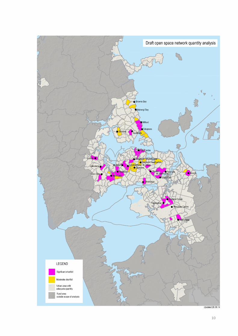
10

Greenfield development areas The following default quantity guidelines for public open space apply to new greenfield development areas which do not have an existing open space network serving residents: Local recreation open space (informal recreation, sport and civic functions)
2 hectares per 400 household units
Sub-regional and regional recreation open space
No quantity guidance, requirements for sub-regional and regional recreational open space will be identified through network planning
Conservation open space (ecology, heritage and landscape functions) Green infrastructure (riparian corridors, stormwater ponds including surrounds)
No quantity guidance, the amount of open space for these functions will depend on the characteristics of the area
The quantity target for local recreation open space is indicative only. Existing open space located nearby, or variation in local demographics and geography, may mean that more or less recreational open space may be required in some situations. The quantity of open space needs to contribute towards achieving the full range of experiences across the open space network described in distribution section of the guidelines4. Some of the experiences (such as suburb parks and local sports parks) may be located outside of the property boundaries of a development area. This means that less than 2ha per 400 households may be required within a development, particularly small developments. Green infrastructure and conservation open space may provide up to 50% of local recreation open space requirements where it has demonstrable recreation benefits. For green infrastructure or conservation open space to provide recreation benefits it should be:
• Of suitable topography and scale to accommodate paths or trails.
• Configured and located to create a contiguous network with other open spaces.
• Able to be accessed safely by the public (such as in terms of natural hazards and CPTED5 principles).
4 Excluding sub-regional parks 5 Crime Prevention Through Environmental Design
11
Configuration of open space Where open space is located and how it is configured in relation to other land uses, such as housing and streets, influences its use and quality. This section of the guidelines sets out some of the layout and configuration factors that determine the success of different types of open space. Informal recreation open space
• Maximise street frontage and locate in prominent locations within a development or neighbourhood to provide good passive surveillance from passer-by’s and neighbouring properties. This will help to make the space well-used and safer.
• Relatively flat terrain is desirable as it provide for a wide range of activities, however some variation in terrain can add interest and play opportunities.
• An open space with relatively equal proportions is best, as this is easy for users to understand and orientate themselves. Avoid overly elongated, narrow or irregular shapes with dead-ends.
• Allow for transition spaces between actively used areas of the park, such as playgrounds or kick-about spaces, and neighbouring properties or streets.
• Provide multiple entrance points and connections through the open space to link with the surrounding neighbourhood
Sport and active recreation open space
• Each sport and activity will have specific requirements for the size, configuration, topography and orientation
• Ensure there is space for safety buffers, walkways, and associated facilities such as clubrooms and car parking
• Consider compatibility with surrounding land uses and allow for a buffer if necessary to address noise and lighting issues.
• Locate many sports facilities on one site to create a hub that allows clubs to share resources and reduce costs
• Co-locate with other recreation facilities, such as a playground and walking circuits to make a multifunctional open space.
• Sports facilities can attract large numbers of visitors and require good access from roads and public transport
• Ensure locations for buildings and structures are both functional and compliment the design and attractiveness of the park.
Civic open space • Locate at prominent focal points where people naturally congregate • Carefully consider the size and proportions of the space in relation to the intended uses.
Large spaces can be great location for events but may not be good as social spaces. • Ensure surrounding buildings front the space and have active uses at street level • Orientate to form a sunny, sheltered space. Consider how surrounding buildings will shade
the space. Take advantage of views to landmarks • Consider opportunities to extend the civic space into the road reserve
Conservation open space
• All the area of conservation value should be included in the open space, along with land to buffer between sensitive areas and other land uses.
• Including sufficient space around built heritage features can help to provide context and assist with people understanding the values.
12

• The configuration of open space conserving natural values should reflect the landform and extent of the area of habitat or feature. A boundary following a contour can be appropriate to incorporate natural features.
• Maximise connections between areas of ecological value • Consider what access is appropriate for the values of the site and purpose of the open
space. Street frontage and public access points may be less important than for other types of open space.
• Varied topography can provide for a range of ecosystems and niches for species, increasing biodiversity.
13