parcel ties - manual · isc land system parcel ties parcel ties - manual ver 2.0 8 plan of survey a...
TRANSCRIPT

ISC LAND System Parcel Ties
Parcel Ties - Manual Ver 2.0 1
Parcel Ties - Manual
DISCLAIMER
The materials in this training manual are for demonstration purposes only. The
forms are subject to change at any time without notice. Use of outdated forms may
result in transactions being rejected or delayed.
Always look to the web site for the most recent versions of the forms.
Information Services Corporation of Saskatchewan will not be responsible for loss
resulting from the use of outdated forms.
© Copyright 2007, Information Services Corporation (ISC) of Saskatchewan.
All rights reserved.
You may not copy, reproduce, translate or reduce to any electronic medium or machine-readable form, in whole or part, without prior written permission of Information Services Corporation (ISC) of Saskatchewan.
While every reasonable precaution has been taken in the preparation of this manual, the author and publishers assume no responsibility for errors or omissions, nor for uses made of the material contained herein and the decision based on such use. Neither the author nor the publishers make any images, warranties or guarantees of any kind, either express or implied. Neither the author nor the publishers shall be liable for any indirect, special, incidental, or consequential damages arising out of the use or inability to use the contents of this book whether the publisher has been advised of the use of this publication or not.

ISC LAND System Parcel Ties
Parcel Ties - Manual Ver 2.0 2
Table of Contents Table of Contents ................................................................... 2 Preliminary .............................................................................. 3
What are Parcel Ties? ......................................................... 3 Related Definitions .............................................................. 4 Statutory Background .......................................................... 9 Conversion – ..................................................................... 10 Application of Parcel Ties .................................................. 10 How do I know if Parcels are Tied? ................................... 11 Requesting a Review/Correction of Parcel Ties ................. 12 A Note About Interest Registrations .................................. 13 Tenant in Common Ownership .......................................... 14
Ownership share must be identical, too. ........................ 14 Examples of Parcel Ties ....................................................... 15
URBAN ............................................................................. 15 Complete lots ................................................................. 15 Whole Lots combined with Metes and Bounds ............... 16 Multiple Metes and Bounds Descriptions/Exceptions ..... 16
RURAL .............................................................................. 17 A road or rail exception that crosses the land ................ 17 A Metes and Bounds exception (e.g. farmyard subdivision) .................................................................... 17 All that portion lying North of Right of Way, Road, River, Lake, etc. ....................................................................... 18 Legal Subdivisions (LSDs) ............................................. 19 Railway Right of Way, Extra Lands and Station Grounds ...................................................................................... 21 School Sites ................................................................... 21 River Lots ...................................................................... 21
PARCEL TIES AND TRANSFORMS .................................... 23 TIES AND TRANSFORMS ................................................ 23
Where the NW is owned by an individual (Mary Smith –client number 987654321) and Parcel A will be transferred to a third party (John Smith) ........................................... 24 Where the NW is owned by an individual (Cathy Jones – client number 134679246), but she will retain Parcel A only and transfer the Quarter to a corporate third party (ABC Farms Ltd.) ........................................................... 25 Where the NW is owned by a corporation (Green Acres Incorporated – convenience client number 134679258) and Parcel A will be transferred to an individual (Michael Bloggins). ....................................................................... 25
Parcels contained within a tied group that are not “active” parcels. ............................................................................. 26
Pending Parcels ............................................................. 26 Disjointed Condominium Plans ...................................... 28
ISC LAND System Parcel Ties
Parcel Ties - Manual Ver 2.0 3
Preliminary
What are Parcel Ties?
Parcel ties (sometimes referred to as “tie codes”) are used to identify parcels that must be dealt with at the same time in the LAND System. Parcel Ties are necessary to ensure that the LAND System complies with the provisions of section 121 of The Planning and Development Act, 2007.
This document explains some of the background related to parcel ties, the process for requesting a review of parcel ties, and some information related to the determination of whether parcel ties are valid or not. It also explains some of the particular considerations when dealing with transforms.

ISC LAND System Parcel Ties
Parcel Ties - Manual Ver 2.0 4
Related Definitions
COBRA-linked client number
A client number for a corporate body that is generated through a download from the Corporations Branch database (COBRA); this entity has the ability to acquire land, provided the corporation is active in Corporations Branch
Convenience Client number
A client number that is system-generated through the conversion of titles; for corporations, this entity does not have the ability to own land, unless it is branched to a COBRA-related number.
Historical Search A search conducted of predecessor Certificates of Title and instruments; in this context, it is used by the Registrar’s Office to determine the circumstances surrounding a subdivision of a parcel of land and any Planning and Development conditions that may have been applied thereto.

ISC LAND System Parcel Ties
Parcel Ties - Manual Ver 2.0 5
Legal Subdivisions The theoretic area by calculation into 1/4s of each Quarter section. Pursuant to the Land Surveys Act Regulations, every quarter section shall be taken to be divided into quarter quarter sections, each of forty acres more or less, which are called Legal Subdivisions. Legal Subdivisions are numbered as shown in the following diagram:
13 14 15 16
12 11 10 9
5 6 7 8
4 3 2 1
NW NE
SW SE

ISC LAND System Parcel Ties
Parcel Ties - Manual Ver 2.0 6
Metes and Bounds Description
A positive land description for which limits or boundaries are defined as marked by natural features or man made structures; a land description that describes the territorial limits of property by means of measuring distances and angles for designated landmarks and in relation to adjoining properties; a description of a parcel of land, in words or numbers, for which a Certificate of Title had been issued pursuant to The Land Titles Act. E.g.:
All that portion of the NE 1-2-3 W3 described as follows: commencing at the North East corner, thence southerly 150’ along the eastern boundary of the quarter section; thence westerly …
All that portion of the NE 1-2-3 W3 lying north of the northerly limit of Right of Way on Plan AB 1234
The most westerly 15 feet in perpendicular width throughout Lot 1, Block 2, Plan 00MJ12345
Legal Subdivision 1 of 1-2-3 W3

ISC LAND System Parcel Ties
Parcel Ties - Manual Ver 2.0 7
Metes and Bounds Exception
A land description that contains an exception of a Metes and Bounds description. E.g.:
The NE 1-2-3 W3, except all that portion described as follows: commencing at the North East Corner, thence southerly 150’ along the eastern boundary of the quarter section; thence westerly…
The NE 1-2-3 W3, except all that portion lying to the North of the Northerly limit of Right of Way on Plan AB 1234
Lot1, Block 2, Plan 00MJ123456, except the most westerly 15 feet in perpendicular width throughout
The SE 1-2-3 W3, except Legal Subdivision 1
All that portion of the NE 1-2-3 W3 not covered by the waters of Lake No. 1 as shown on Township Plan dated June 1, 1905.
Pending Parcel A parcel which has been created for a Transform in PPS and to which a Title record is eligible to be raised in TPS, but for which a Title has not yet been raised
Plan Exception A land description that contains an exception of a registered Plan of Survey. E.g.:
The NE 1-2-3 W3, except 0.91 acres for Roadway on Plan AB 1234
Plan Processing System (PPS)
The automated system used to maintain all legal survey information and deliver the approval process required to file plans in the Land Surveys Registry. Equivalent to the role performed by the Chief Surveyor’s Office and the Controller of Surveys prior to conversion.
Planning Approval Usually a Certificate of Approval issued by the Community Planning Office or by the urban municipality

ISC LAND System Parcel Ties
Parcel Ties - Manual Ver 2.0 8
Plan of Survey A plan prepared by a surveyor in the prescribed manner that illustrates any boundary of a parcel and which has been either registered in the Land Titles Office or filed in the LAND system but does not include a descriptive plan
Remainder Parcel In a typical subdivision Transform, the parcel that remains after the subdivided portion is removed.
Source Parcel(s) The parcel(s) being reconfigured in a Transform
Square Water This situation where water is excluded from a land description in terms of Legal Subdivisions or portions of Legal Subdivisions, rather than in terms of a line drawn on a township plan which closely follows that actual contours of the water body.
Target Parcel(s) The new parcels created by a Transform
Title Processing System (TPS)
The automated system used for the titling of land and registration of interests. Equivalent to the role performed by the Land Titles Offices prior to conversion.
Transform The process used to re-configure or redefine (usually subdivision or consolidation) a graphical area on a plan by PPS; once the preparation of a Transform by PPS is complete, a Transform Approval Certificate will be issued.
Transform Approval Certificate (TAC)
Once the Controller of Surveys has approved a plan and a Transform has been prepared by PPS, a Transform Approval Certificate (TAC) will be issued by Plan Processing. The Transform Approval Certificate (TAC) details both the source parcels and the new or target parcels, and any changes from the source to new parcels, including any change in the parcel class codes.
Transform Packet The packet registered in TPS to raise Titles to the new parcel(s) created in a Transform

ISC LAND System Parcel Ties
Parcel Ties - Manual Ver 2.0 9
Statutory Background Section 20 of The Land Titles Act, 2000 Regulations provides that where an application (such as a transfer) is based on a transaction that requires consent or authorization of a party pursuant to an Act, the Registrar may require the applicant to submit evidence satisfactory to the Registrar to prove that all other conditions precedent have been satisfied. Section 31 of The Land Titles Act, 2000 (LTA) provides that the Registrar may refuse to register any application that does not comply with the Act or Regulations, or any other Act pursuant to which the registration is authorized.
Subdivision of parcels is governed by The Planning and Development Act, 2007 (P&DA). Section 120(2) of the P&DA states that parcels of land are linked together to prevent those parcels from being individually dealt with in the land registry if the situation involves:
a) a legal subdivision in a quarter section as legalsubdivision is defined in section 131 of The LandSurveys Regulations;
b) parcels deemed to be on one parcel of landpursuant to any former Act;
c) parcels that are separated by an approved plan ornatural boundary;
d) parcels held under one certificate of title prior to theimplementation of The Land Titles Act, 2000;
e) a parcel required to be consolidated with all or partof another parcel by a certificate of approval issuedpursuant to another act;
f) a parcel required to be linked by a parcel tie toanother parcel as a condition of approval tosubdivide land pursuant to the P&DA.
Section 121(2) of the P&DA prohibits subdivision of parcels unless the appropriate planning authority has issued a certificate of approval respecting the subdivision.
The Registrar has the authority to determine the manner of ensuring compliance with s. 20 of the LTA regulations. We have chosen to do so by the imposition of a restriction on the transfer of certain parcels in certain circumstances, which has taken the form of parcel ties. This restriction will be lifted in one of three circumstances:
a) if, after a review of the parcels in question, it isdetermined that the ties were placed on the parcelsin error. They will be removed by Registrar’scorrection, as authorized pursuant to section 97 ofthe LTA;

ISC LAND System Parcel Ties
Parcel Ties - Manual Ver 2.0 10
b) evidence of the satisfaction of the prerequisitescontained in s. 121(2) of the P&DA is provided.The Registrar requires this evidence to be in theform the registration of a Transform, which createsnew parcel(s) from the original parcel(s). Althoughthe boundaries of each area may be the same, theTransform acts to change the deemed single parcelinto two new, separate parcels. In some cases, thechange is the removal of Parcel ties, rather than themore usual situation of an actual change to theboundaries of a parcel; or
c) The Controller of Surveys may remove parcel tieswhere valid Planning Approval or a Letter ofConsent from the Director of Community Planninghas been received and the reference landdescriptions for the parcels is different.
Conversion – Application of Parcel Ties
To ensure that the Registry meets its obligations under The Planning and Development Act, the Conversion software was designed to automatically apply ties to all parcels generated from a single Certificate of Title where the land described contains at least one Metes and Bounds Exception, Plan Exception or Metes and Bounds Description. Metes and Bounds descriptions include not only the typical form of Metes and Bounds descriptions, but also Legal Subdivision descriptions and descriptions such as “all that portion of Quarter Section, not covered by the waters of Lake No. 1, as shown on Township Plan dated April 1, 1905”. Changes were made to the Conversion software in September 2002 to reduce the number of invalid application of tie codes in cases where only a Plan Exception was excluded from the description.
There is no human discretion applied at the time that the tie codes are placed; therefore, it is not uncommon that ties may be over-applied to parcels. In those situations, the Registrar has the authority to correct the error. However, the authority is limited to correction of errors made in the land registry; it does not extend to removal of parcel ties in situations where they were correctly applied.

ISC LAND System Parcel Ties
Parcel Ties - Manual Ver 2.0 11
How do I know if Parcels are Tied?
You may identify that a Title has parcel ties associated with it in one of three ways:
A Note at the bottom of the Title print (either Quick SearchTitle Print or requested output Titles) as follows:
Displayed on the Quick Search intermediate results screenas follows:
Displayed on Title/Parcel Search results, as follows:
The “Validated Ties” information indicates whether the parcel ties have been reviewed by the Registry.
A “Yes” in this column indicates that the parcel tie group has been reviewed by the Registry and has been determined to be correct. If a transfer of less than the entire parcel group is required, approval from the appropriate planning authority will need to be obtained. Please contact the appropriate planning authority (usually the City for the larger Urban centres or the Community Planning Branch of Government Relations and Aboriginal Affairs for smaller communities and rural areas) or Plan Processing for further information on the process or requirements for subdivision approval.

ISC LAND System Parcel Ties
Parcel Ties - Manual Ver 2.0 12
A “No” in this column indicates that the Registry has not yet completed a review of the parcel group. The group may or may not be correct - Please contact ISC to initiate a review if you wish to transfer less than the entire parcel group. (See below)
Requesting a Review/Correction of Parcel Ties
If parcel ties have not been validated and you believe them to be in error, you may request that the Registrar’s Office review the parcel ties, with a view to correction if appropriate. To do
so, please contact the Customer Call Centre at [email protected] or 1-866-275-4721. The CCC will obtain the
required information and forward your request to the appropriate resources. If the parcel ties are amended, a Registrar’s Notice will be registered against the Titles affected for thirty days. Copies of the Titles will be sent to you to confirm the amendment of the ties. In the event the ties are valid and, therefore, will not be removed by the Registrar’s Office, you will be contacted with this information.

ISC LAND System Parcel Ties
Parcel Ties - Manual Ver 2.0
13
A Note About Interest Registrations When a packet containing an application for a change in ownership of a parcel of land (Transfer, Transmission, Application by Surviving Joint Tenant or Transform), the Title Processing System (TPS) performs a validation check at the completion of all applications in that packet. This validation check will return an error message when the ownership of all parcels within a tied group of parcels in not identical. However, the same check is not performed by TPS for interest registrations. Therefore, a packet that requests that an interest be registered against only one of several in a tied group of parcels may be submitted and successfully registered. The onus is on the submitting party to ensure compliance with Section 121 of The Planning and Development Act, 2007. Sections 121(3) of the P&DA provide that no person shall register certain interests (which include leases, mortgages and agreements for sale) against only part of a parcel of land, unless a certificate of approval has been obtained from the appropriate planning authority. Section 122(5) provides that such an interest registered without the appropriate approval is invalid. Section 122(3) provides that the Registrar of Titles is not required to confirm compliance with this section when accepting an application for interest registration. Therefore, while TPS may allow the registration of an interest, this is no indication that this transaction is, in fact, a valid registration pursuant to the P&DA.
ISC LAND System Parcel Ties
Parcel Ties - Manual Ver 2.0 14
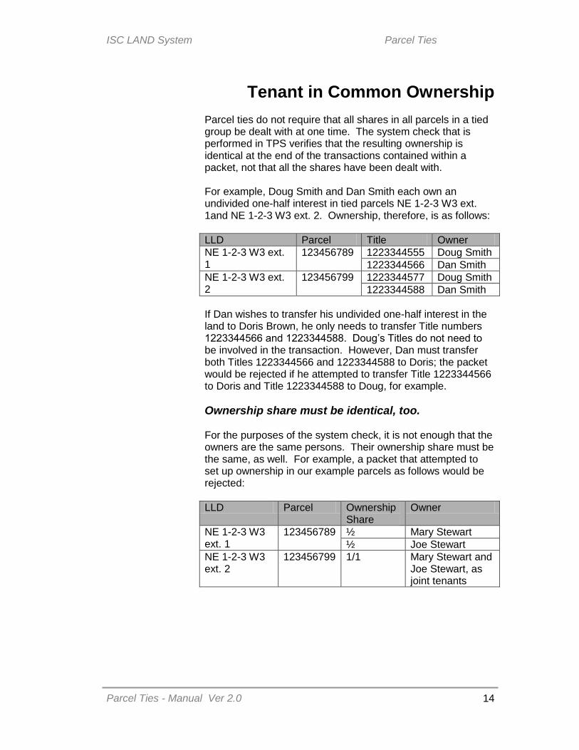
Tenant in Common Ownership
Parcel ties do not require that all shares in all parcels in a tied group be dealt with at one time. The system check that is performed in TPS verifies that the resulting ownership is identical at the end of the transactions contained within a packet, not that all the shares have been dealt with.
For example, Doug Smith and Dan Smith each own an undivided one-half interest in tied parcels NE 1-2-3 W3 ext. 1and NE 1-2-3 W3 ext. 2. Ownership, therefore, is as follows:
LLD Parcel Title Owner
NE 1-2-3 W3 ext. 1
123456789 1223344555 Doug Smith
1223344566 Dan Smith
NE 1-2-3 W3 ext. 2
123456799 1223344577 Doug Smith
1223344588 Dan Smith
If Dan wishes to transfer his undivided one-half interest in the land to Doris Brown, he only needs to transfer Title numbers 1223344566 and 1223344588. Doug’s Titles do not need to be involved in the transaction. However, Dan must transfer both Titles 1223344566 and 1223344588 to Doris; the packet would be rejected if he attempted to transfer Title 1223344566 to Doris and Title 1223344588 to Doug, for example.
Ownership share must be identical, too.
For the purposes of the system check, it is not enough that the owners are the same persons. Their ownership share must be the same, as well. For example, a packet that attempted to set up ownership in our example parcels as follows would be rejected:
LLD Parcel Ownership Share
Owner
NE 1-2-3 W3 ext. 1
123456789 ½ Mary Stewart
½ Joe Stewart
NE 1-2-3 W3 ext. 2
123456799 1/1 Mary Stewart and Joe Stewart, as joint tenants

ISC LAND System Parcel Ties
Parcel Ties - Manual Ver 2.0
15
Examples of Parcel Ties The Registrar’s Office will remove invalid parcel ties upon request. However, before ties are removed, a review must be conducted of the parcels in question to ensure that the parcels may be dealt with independently without a Certificate of Approval. This review may involve a historical review of the previous Certificates of Titles for this land to determine whether parcels must be dealt with together as a single parcel. The review, to determine if the ties were applied in error, is designed to conform to the practice in the Land Titles Offices prior to conversion as closely as possible.
Each situation is unique. The following provides only guidelines for the most common situations, divided into segments on Urban areas, Rural areas and special guidelines where Transforms are involved. However, it is important to remember that historical research is often required to be completed by the Registrar’s Office in order to determine whether ties should be removed or not.
URBAN Parcel ties in Urban areas usually occur on older plans (older areas of a City, or small towns). Most new urban subdivisions result in one Lot per Title. In urban areas, parcel ties result when a Land Description contains a description of something less than a full lot as shown on a registered Plan.
Complete lots If all of the lots described on a Certificate of Title are whole lots, ties will not be applied between the parcels.
The decision not to tie complete lots from a single Certificate of Title was made to conform to the practice in the Land Titles Offices prior to conversion. The existence or absence of a building that may straddle two or more lots was not recorded on the Certificates of Title or elsewhere within the Land Titles Offices. As there was no way for Land Titles to know whether there was a building on all or part of a lot, this was not a consideration when determining whether lots could be transferred independently under the old-paper based system. As well, The Planning and Development Act, 2007 does not require us to take into consideration the location of any buildings on land that is being transferred. This approach has been carried forward from the Land Titles Offices into the LAND System.
ISC LAND System Parcel Ties
Parcel Ties - Manual Ver 2.0
16
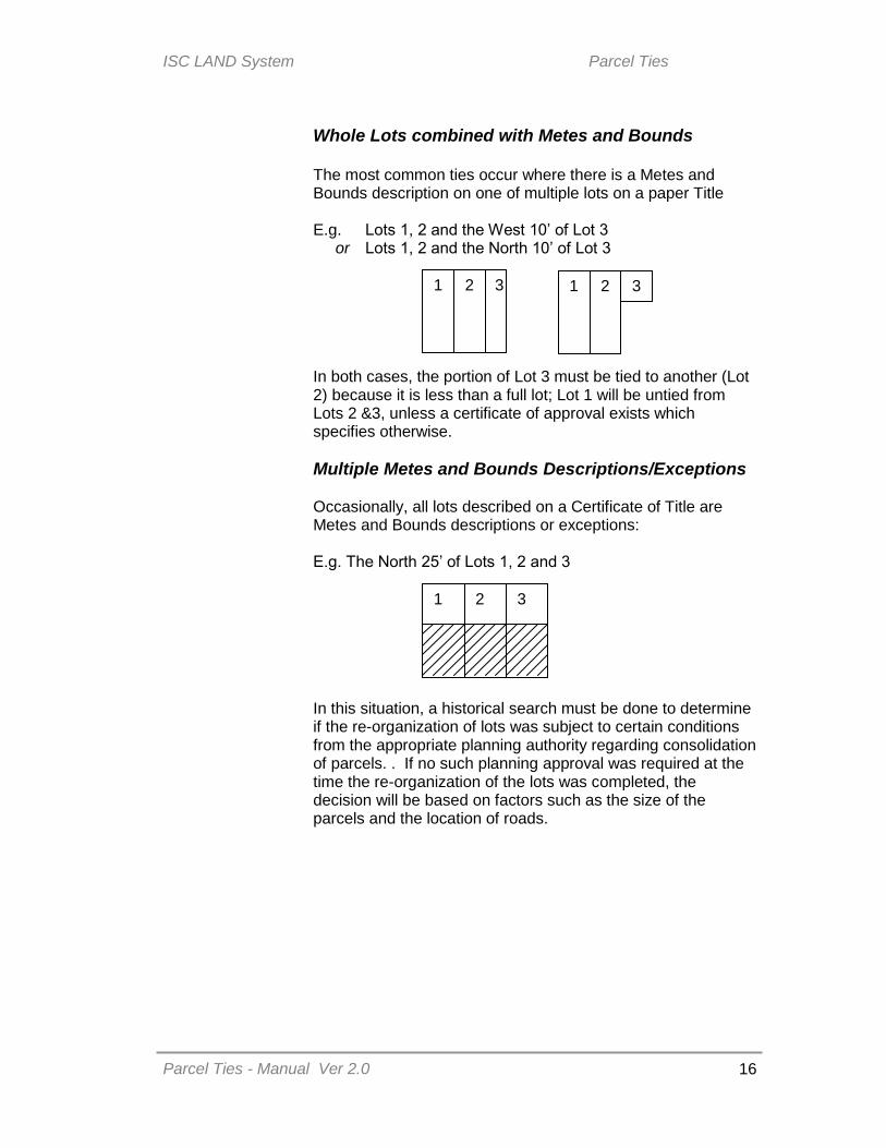
Whole Lots combined with Metes and Bounds The most common ties occur where there is a Metes and Bounds description on one of multiple lots on a paper Title E.g. Lots 1, 2 and the West 10’ of Lot 3 or Lots 1, 2 and the North 10’ of Lot 3 In both cases, the portion of Lot 3 must be tied to another (Lot 2) because it is less than a full lot; Lot 1 will be untied from Lots 2 &3, unless a certificate of approval exists which specifies otherwise.
Multiple Metes and Bounds Descriptions/Exceptions Occasionally, all lots described on a Certificate of Title are Metes and Bounds descriptions or exceptions: E.g. The North 25’ of Lots 1, 2 and 3 In this situation, a historical search must be done to determine if the re-organization of lots was subject to certain conditions from the appropriate planning authority regarding consolidation of parcels. . If no such planning approval was required at the time the re-organization of the lots was completed, the decision will be based on factors such as the size of the parcels and the location of roads.
1 2 3 1 2 3
1
2
3

ISC LAND System Parcel Ties
Parcel Ties - Manual Ver 2.0
17
RURAL In rural areas, the basic unit is the Quarter Section (River Lot in some areas of the former Battleford and Prince Albert Land Registration Districts).
A road or rail exception that crosses the land For example: The North-East and South-East of 1-2-3 W3, except out of the NE, Right of Way on Plan AB1234 (Railway) The two parcels of the NE are considered as a single parcel and need to remain tied to each other; however, the SE does not need to be tied to the NE. Many of these parcel ties were corrected as part of a bulk correction completed in June 2003.
A Metes and Bounds exception (e.g. farmyard subdivision) For Example: The North-East and South-East of 1-2-3 W3, except the most northerly 150’ of the most easterly 200’ from the NE The NE and SE do not need to be tied together and the parcel ties may be removed by Registrar’s Correction.
NE
SE
NE
SE
NOTE
ISC LAND System Parcel Ties
Parcel Ties - Manual Ver 2.0
18
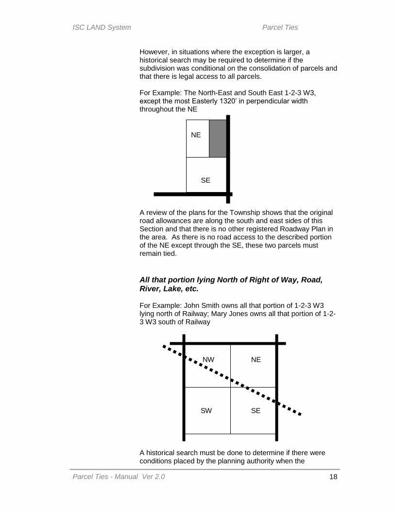
However, in situations where the exception is larger, a historical search may be required to determine if the subdivision was conditional on the consolidation of parcels and that there is legal access to all parcels. For Example: The North-East and South East 1-2-3 W3, except the most Easterly 1320’ in perpendicular width throughout the NE
A review of the plans for the Township shows that the original road allowances are along the south and east sides of this Section and that there is no other registered Roadway Plan in the area. As there is no road access to the described portion of the NE except through the SE, these two parcels must remain tied.
All that portion lying North of Right of Way, Road, River, Lake, etc. For Example: John Smith owns all that portion of 1-2-3 W3 lying north of Railway; Mary Jones owns all that portion of 1-2-3 W3 south of Railway A historical search must be done to determine if there were conditions placed by the planning authority when the
NE
SE
NW
NE
SW
SE
ISC LAND System Parcel Ties
Parcel Ties - Manual Ver 2.0
19
severance was approved. Most often, however, descriptions such as this pre-dated The Planning and Development Act, 2007 and the prior The Planning and Development Act, 1983. Here, we are concerned primarily with access. The three parcels north of the railway may be untied, as there are road allowances providing access to all three parcels. However, for the parcels south of the railway, the portion of the NE has no road access. It must be tied either to the portion of the SE or NW (or both). In this instance, we will contact the owner (or proposed purchaser) to request an election in this regard.
Legal Subdivisions (LSDs) Legal Subdivisions are a theoretic area by calculation into ¼’s of each quarter section. They are not treated the same as subdivided parcels on a registered Plan of Survey. Remember that the basic unit is the Quarter section. Notwithstanding the description as separate LSDs, some or all may need to remain tied. Often, the LSD description acts as a short-form Metes and Bounds description: rather than saying the North half of the SE quarter, the same could be described as LSDs 7 & 8, for example. Historical searches must be completed in these situations. Prior to April 1, 1984, owners could request subdivision into Legal Subdivisions without any planning authority authorization. However, since that date, subdivision into LSDs has been treated the same as any other subdivision. Unless Approval exists for the transfer into separate LSDs, those LSDs which originated from a single Quarter section and which remain on a single Certificate of Title will remain tied. The location of registered road plans or Original Road Allowances are also important considerations in determining whether the parcel ties for Legal Subdivisions are valid.
NOTE

ISC LAND System Parcel Ties
Parcel Ties - Manual Ver 2.0
20
E.g. Historical search shows that A was the owner of the SE 1-2-3 W3. LSDs 1 & 2 were transferred to B in 1980, leaving LSDs 7 & 8 held by A. LSDs 1 & 2 need to remain tied together and LSDs 7 & 8 need to remain tied together. Owned by A Owned by B
Some LSD descriptions date back to the original Grant of land from the Crown and refer to LSDs as a method of excepting water bodies. In these cases, the review of the township plat will often suggest the intention of the parties to create a single parcel of land. Therefore, they will remain tied. E.g. Grant was for the NW, NE and SW quarters of LSD 1, all of LSD 2, LSD 7 & LSD 8, except those portions covered by Lake No. 1. All portions need to remain tied together.
Lake
This is also sometimes described in terms of “square water”. The Grant will be for, e.g. LSDs 2, 7, 8 and the West half and NE quarter of LSD 1. The township plat shows that the
SE
LSD7 LSD8
LSD2 LSD1
LSD 7 LSD 8 LSD 2
ISC LAND System Parcel Ties
Parcel Ties - Manual Ver 2.0
21
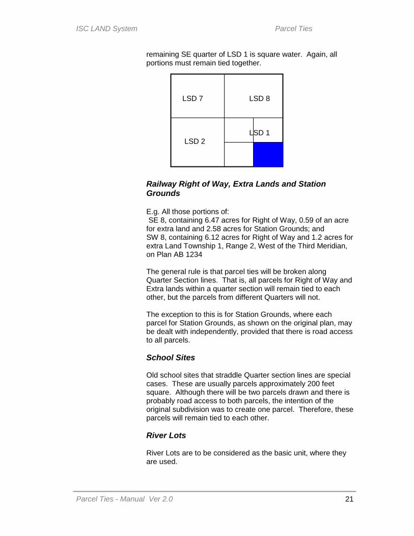
remaining SE quarter of LSD 1 is square water. Again, all portions must remain tied together.
Railway Right of Way, Extra Lands and Station Grounds E.g. All those portions of: SE 8, containing 6.47 acres for Right of Way, 0.59 of an acre for extra land and 2.58 acres for Station Grounds; and SW 8, containing 6.12 acres for Right of Way and 1.2 acres for extra Land Township 1, Range 2, West of the Third Meridian, on Plan AB 1234 The general rule is that parcel ties will be broken along Quarter Section lines. That is, all parcels for Right of Way and Extra lands within a quarter section will remain tied to each other, but the parcels from different Quarters will not. The exception to this is for Station Grounds, where each parcel for Station Grounds, as shown on the original plan, may be dealt with independently, provided that there is road access to all parcels.
School Sites Old school sites that straddle Quarter section lines are special cases. These are usually parcels approximately 200 feet square. Although there will be two parcels drawn and there is probably road access to both parcels, the intention of the original subdivision was to create one parcel. Therefore, these parcels will remain tied to each other.
River Lots River Lots are to be considered as the basic unit, where they are used.
LSD 7 LSD 8
LSD 1 LSD 2

ISC LAND System Parcel Ties
Parcel Ties - Manual Ver 2.0
22
River lots also have the unique quality of sometimes bridging Original Road Allowances. For example, River Lot 2 Township 45, Range 5, West of the Third Meridian (below) is divided in four parcels by the river and the Original Road Allowance. These parcels must remain tied to each other.
Occasionally, River Lots will cross Townships and Ranges. Multiple parcels may be created to accommodate entry into the LAND system. However, the basic unit is still the River Lot and all parcels of each must be tied to each other. If there have been any Metes and Bounds exceptions taken from the original River Lot, a full historical review must be completed to determine the circumstances of the subdivision and whether the parcel ties are valid or not.

ISC LAND System Parcel Ties
Parcel Ties - Manual Ver 2.0
23
PARCEL TIES AND TRANSFORMS Transforms require special consideration of ties. Although Plan Processing does complete a cursory review of parcel ties for conversion errors when the Transform Approval Certificate is prepared and may request a parcel tie review be initiated, is important to check for parcel ties before submitting a Transform packet.
TIES AND TRANSFORMS Where a source parcel is tied to another, the ties will not prevent registration of the Transform. However, care must be taken to set-up the transaction properly. This is to comply with the requirement that all parcels in a tied group must have the same ownership and that the computerized LAND system only recognizes owners as being the “same” if the same client number is used. Sometimes, this will require multiple steps. For Example: The NW 1-2-3 W3 is split into two parcels (NW ext. 1 and NW ext. 2) by a Roadway.
Parcel A is being subdivided from the NW ext. 2. New parcel NW ext. 3 is created for the remainder of the larger piece of the NW
NW ext1 NW ext. 3
A
NW ext1 NW ext. 2

ISC LAND System Parcel Ties
Parcel Ties - Manual Ver 2.0
24
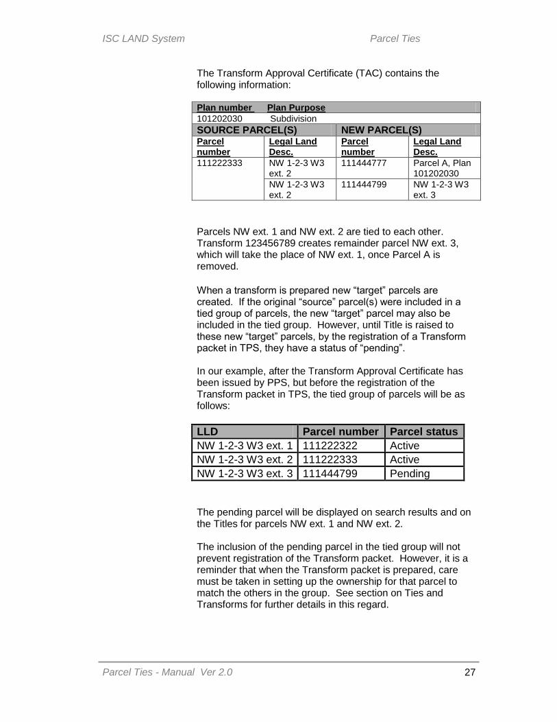
The Transform Approval Certificate (TAC) contains the following information: Plan number Plan Purpose
101202030 Subdivision
SOURCE PARCEL(S) NEW PARCEL(S)
Parcel number
Legal Land Description
Parcel number
Legal Land Description
111222333 NW 1-2-3 W3 ext. 2
111444777
Parcel A, Plan 101202030
NW 1-2-3 W3 ext. 2
111444799 NW 1-2-3 W3 ext. 3
New parcel 111444799, for the “remainder parcel” NW 1-2-3 W3 ext. 3 will be automatically added to the tied group of parcels (NW 1-2-3 W3 ext. 1 & ext. 2). The “pending” parcel 111444799 (that is, a parcel that has been created by Plan Processing, but for which no Title has yet been raised) will appear in web searches and on Title prints. Searches of this parcel will bring back a “No records found” message. The requirements for successfully completing this subdivision depend on the current and future owners of the parcels.
Where the NW is owned by an individual (Mary Smith –client number 987654321) and Parcel A will be transferred to a third party (John Smith) Parcel 111444777 (Parcel A) will be set up in the name of
John Smith; there are no special requirements for the client number used for this set up.
Parcel 111444799 (NW 1-2-3 W3 ext. 3) must be set up in
the name of Mary Smith, using client number 987654321. If any changes are required to the name or address associated with that client number, these changes must be made by separate application for name change or client number amendment, as the case may be.

ISC LAND System Parcel Ties
Parcel Ties - Manual Ver 2.0
25
Where the NW is owned by an individual (Cathy Jones – client number 134679246), but she will retain Parcel A only and transfer the Quarter to a corporate third party (ABC Farms Ltd.) This requires a two-step process, to be completed in two separate packets. If both steps are submitted in a single packet, the packet will be rejected. 1. First Packet: Titles must be raised for the new parcels
created by the Transform. Parcel 111444777 (Parcel A) should be set up in the
name of Cathy Jones. There are no special requirements for the client number used for this set-up.
Parcel 111444799 (NW 1-2-3 W3 ext. 3) must be set up in the name of Cathy Jones, using client number 134679246.
2. Second packet: Titles for the parcels of NW 1-2-3 W3 ext.
1 and NW 1-2-3 W3 ext. 3 must be transferred to ABC Farms Ltd. These must be set up using a COBRA-related client number for ABC Farms Ltd.
Where the NW is owned by a corporation (Green Acres Incorporated – convenience client number 134679258) and Parcel A will be transferred to an individual (Michael Bloggins). Green Acres holds the land with “convenience” client number 134679258, which was assigned to Green Acres upon conversion of the Certificate of Title, but which is not a COBRA-related number. Green Acres must first do a Client Amalgamation or a
Client Branching so that “convenience” client number 134679258 is linked to the COBRA number.
Parcel 111444777 (Parcel A) should be set up in the name
Michael Bloggins. There are no special requirements for the client number used for this set-up.
Parcel 111444799 (NW 1-2-3 W3 ext. 3) must be set up in
the name of Green Acres Incorporated. The client number used will depend on whether they have amalgamated or branched the client numbers.
If the branching option was chosen, the convenience number is used to set up the remainder parcel.
If the amalgamation option was chosen, the COBRA- linked number is used to set up the remainder parcel.

ISC LAND System Parcel Ties
Parcel Ties - Manual Ver 2.0
26
Parcels contained within a tied group that are not “active” parcels.
Pending Parcels When a transform is pending, there may be instances where a search of one or more parcels in a tied group may return a “no results found” message. The Transform may be been created either at the request of the Registrar’s Office to complete a parcel count correction, or at a landowner’s request for a subdivision or consolidation. For Example: The NW 1-2-3 W3 is split into two parcels (NW ext. 1 (parcel 111222322) and NW ext. 2 (parcel 111222333) by a Roadway.
Parcel A is being subdivided from the NW ext. New parcel NW ext. 3 (parcel 111444799) is created for the remainder of the larger piece of the NW
NW ext1 NW ext. 3
A
NW ext1 NW ext. 2
ISC LAND System Parcel Ties
Parcel Ties - Manual Ver 2.0
27
The Transform Approval Certificate (TAC) contains the following information: Plan number Plan Purpose
101202030 Subdivision
SOURCE PARCEL(S) NEW PARCEL(S) Parcel number
Legal Land Desc.
Parcel number
Legal Land Desc.
111222333 NW 1-2-3 W3 ext. 2
111444777 Parcel A, Plan 101202030
NW 1-2-3 W3 ext. 2
111444799 NW 1-2-3 W3 ext. 3
Parcels NW ext. 1 and NW ext. 2 are tied to each other. Transform 123456789 creates remainder parcel NW ext. 3, which will take the place of NW ext. 1, once Parcel A is removed.
When a transform is prepared new “target” parcels are created. If the original “source” parcel(s) were included in a tied group of parcels, the new “target” parcel may also be included in the tied group. However, until Title is raised to these new “target” parcels, by the registration of a Transform packet in TPS, they have a status of “pending”. In our example, after the Transform Approval Certificate has been issued by PPS, but before the registration of the Transform packet in TPS, the tied group of parcels will be as follows:
LLD Parcel number Parcel status
NW 1-2-3 W3 ext. 1 111222322 Active
NW 1-2-3 W3 ext. 2 111222333 Active
NW 1-2-3 W3 ext. 3 111444799 Pending
The pending parcel will be displayed on search results and on the Titles for parcels NW ext. 1 and NW ext. 2. The inclusion of the pending parcel in the tied group will not prevent registration of the Transform packet. However, it is a reminder that when the Transform packet is prepared, care must be taken in setting up the ownership for that parcel to match the others in the group. See section on Ties and Transforms for further details in this regard.

ISC LAND System Parcel Ties
Parcel Ties - Manual Ver 2.0
28
Disjointed Condominium Plans Very occasionally, a Condominium parcel will be tied to other parcels, which return a “no results found” message. This occurs when the land upon which the Condominium is located is in two or more separate pieces. Under the legislative requirements for Condominiums, all Titles for a Condominium Plan must be issued from a single Condominium Parcel. However, so that we can provide a parcel picture for the land the Condominium sits on, the Condominium parcel is linked to other parcels. Because these other parcels have no Titles issued from them, they cannot be searched in the usual manner. However, a Search of the Condominium Parcel will show the tied parcels. Opening those parcels will allow you to view the parcel pictures associated with each. These ties do not affect the ability to deal with either the Condominium Plan as a whole or the Titles to the individual units.