pantone: 378c pantone: 185 c pantone: 130c lion’s head ... head guide.pdf · with the extremely...
TRANSCRIPT
RobbenIsland Atlantis
sand dunes
Koeberg NuclearPower Station Hill where the Battle of
Blaauwberg took place
Bloubergstrand
Cape TownStadium
Paarl Rock
HelderbergMowbray Ridge
Minor Peak
Table Bay Green Point
Signal Hill
V&A Waterfront
Paardeberg
Tygerberg
Duncan DockBen Schoeman Dock
Du Toit’s Peak
Company’s Garden
Simonsberg
Stellenbosch
Jonkershoek
Molteno Reservoir
Saddle
Knife Edge Silverstream Buttress
Devil’s Peak Platteklip Gorge
Cable station BarrierButtress
Blinkwater Needle
PorcupineButtress
JubileeButtress
ValkenButtress
KasteelsButtress
PosternButtress
SpringButtress
WoodButtress
Oppels Kop
TableMountain
Arrow Buttress
VensterButtress Kloof Corner Ridge
SlangolieButtress
Corridor Buttress
Grootkop
Separation Buttress
Pimple Buttress
Karbonkelberg
...for a memorial hereafter we have made a heap of stones on a hill lying west-south-west from the road in the said bay, and call it by the name ‘King James His Mount’.
Lion’s Head (Leeukop) Spiral Path • 670 metres • Trig Beacon 51English Naval Officers, Humphrey Fitzherbert and Andrew Shillinge, issued a proclamation annexing Table Bay in the name of King James I.
GATEWAYGUIDES
Lion’s Head
Cape Point
Cape Town
Muizenberg
False BaySpiral Route
The start of the Spiral Route up Lion’s Head. Remember to bring a tip for the car guard.
Walking through the Silver Tree forest at the end of the jeep track just after the paragliding launch site.
Walking along the western flank of Lion’s Head, you will find a good outcrop of the Graafwater Formation just above the path on your right. Below the path (bottom left of the photo) you will seean outcrop of Cape Granite, which underlies this formation. ‘An easy day for the ladies’. This photograph, taken in the very
early 1900s, shows a group on the lower set of chains, which still exist. This was part of the original route which included the rock bed directly below the present-day chain section. Note the thick-bedded Peninsula Formation (gaps between horizontal cracks greater than 30 cm). Courtesy of Cape Archives
There used to be a pine tree here which marked the position of the first chainson the old historical route.
First steel ladder
Exposed chain handrail
Old climber’s watering hole(The water is not safe to drink now.)
Staples and chains(previously known as the chain ladder)
Follow the three remaining Stone Pine trees, which have been left as route markers to the summit ridge.
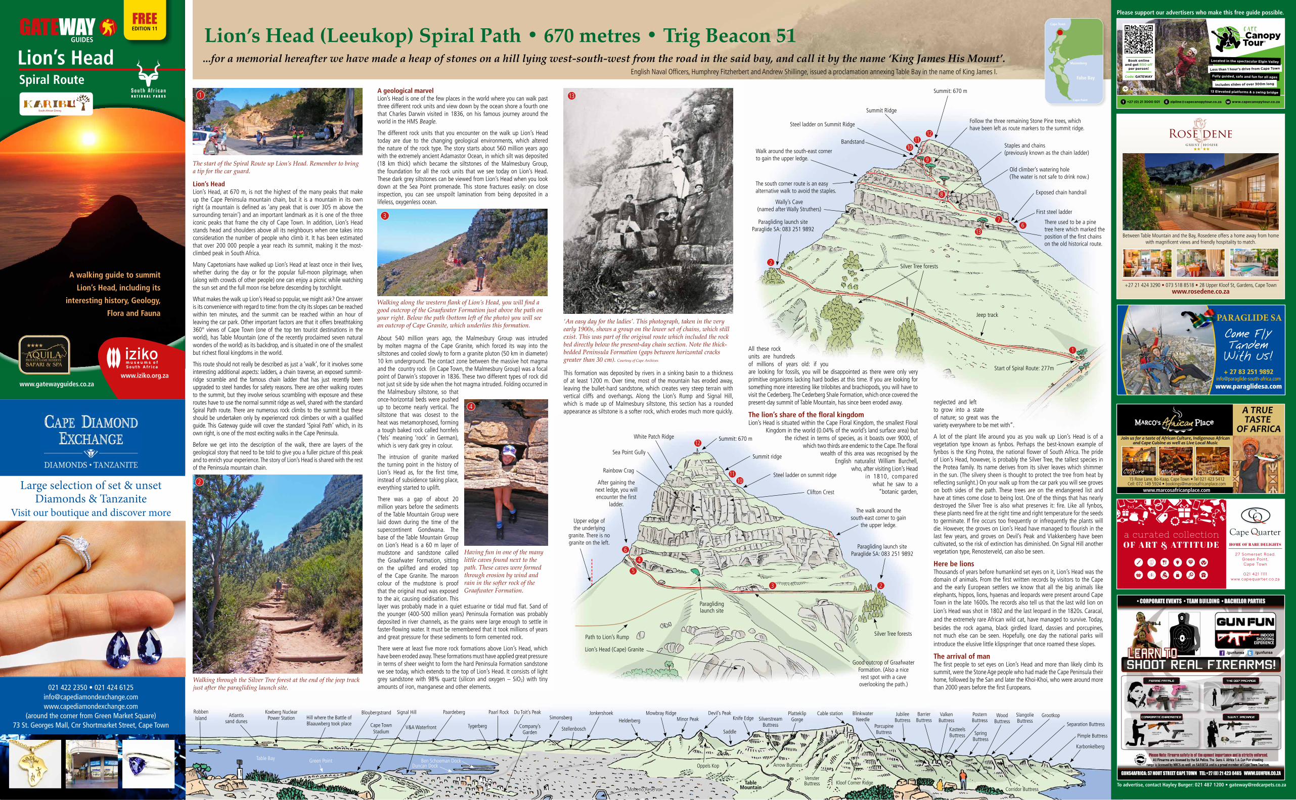
Summit: 670 m
Summit Ridge
Steel ladder on Summit Ridge
Walk around the south-east corner to gain the upper ledge.
The south corner route is an easy alternative walk to avoid the staples.
Paragliding launch siteParaglide SA: 083 251 9892
Silver Tree forests
Jeep track
Start of Spiral Route: 277m
Summit: 670 m
Summit ridge
Steel ladder on summit ridge
Clifton Crest
The walk around the south-east corner to gain
the upper ledge.
Silver Tree forests
Good outcrop of Graafwater Formation. (Also a nicerest spot with a cave
overlooking the path.)
White Patch Ridge
Sea Point Gully
Rainbow Crag
After gaining the next ledge, you will encounter the first
ladder.
Paraglidinglaunch site
Path to Lion’s Rump
Lion’s Head (Cape) Granite
12
1110
6
4
5
3 2
1
136
7
8
9
1011
12
13
3
2
Lion’s HeadLion’s Head, at 670 m, is not the highest of the many peaks that make up the Cape Peninsula mountain chain, but it is a mountain in its own right (a mountain is defined as ‘any peak that is over 305 m above the surrounding terrain’) and an important landmark as it is one of the three iconic peaks that frame the city of Cape Town. In addition, Lion’s Head stands head and shoulders above all its neighbours when one takes into consideration the number of people who climb it. It has been estimated that over 200 000 people a year reach its summit, making it the most-climbed peak in South Africa.
Many Capetonians have walked up Lion’s Head at least once in their lives, whether during the day or for the popular full-moon pilgrimage, when (along with crowds of other people) one can enjoy a picnic while watching the sun set and the full moon rise before descending by torchlight.
What makes the walk up Lion’s Head so popular, we might ask? One answer is its convenience with regard to time: from the city its slopes can be reached within ten minutes, and the summit can be reached within an hour of leaving the car park. Other important factors are that it offers breathtaking 360° views of Cape Town (one of the top ten tourist destinations in the world), has Table Mountain (one of the recently proclaimed seven natural wonders of the world) as its backdrop, and is situated in one of the smallest but richest floral kingdoms in the world.
This route should not really be described as just a ‘walk’, for it involves some interesting additional aspects: ladders, a chain traverse, an exposed summit-ridge scramble and the famous chain ladder that has just recently been upgraded to steel handles for safety reasons. There are other walking routes to the summit, but they involve serious scrambling with exposure and these routes have to use the normal summit ridge as well, shared with the standard Spiral Path route. There are numerous rock climbs to the summit but these should be undertaken only by experienced rock climbers or with a qualified guide. This Gateway guide will cover the standard ‘Spiral Path’ which, in its own right, is one of the most exciting walks in the Cape Peninsula.
Before we get into the description of the walk, there are layers of the geological story that need to be told to give you a fuller picture of this peak and to enrich your experience. The story of Lion’s Head is shared with the rest of the Peninsula mountain chain.
A geological marvelLion’s Head is one of the few places in the world where you can walk past three different rock units and view down by the ocean shore a fourth one that Charles Darwin visited in 1836, on his famous journey around the world in the HMS Beagle.
The different rock units that you encounter on the walk up Lion’s Head today are due to the changing geological environments, which altered the nature of the rock type. The story starts about 560 million years ago with the extremely ancient Adamastor Ocean, in which silt was deposited (18 km thick) which became the siltstones of the Malmesbury Group, the foundation for all the rock units that we see today on Lion’s Head. These dark grey siltstones can be viewed from Lion’s Head when you look down at the Sea Point promenade. This stone fractures easily: on close inspection, you can see unspoilt lamination from being deposited in a lifeless, oxygenless ocean.
This formation was deposited by rivers in a sinking basin to a thickness of at least 1200 m. Over time, most of the mountain has eroded away, leaving the bullet-hard sandstone, which creates very steep terrain with vertical cliffs and overhangs. Along the Lion’s Rump and Signal Hill, which is made up of Malmesbury siltstone, this section has a rounded appearance as siltstone is a softer rock, which erodes much more quickly.
All these rock units are hundreds of millions of years old: if you are looking for fossils, you will be disappointed as there were only very primitive organisms lacking hard bodies at this time. If you are looking for something more interesting like trilobites and brachiopods, you will have to visit the Cederberg. The Cederberg Shale Formation, which once covered the present-day summit of Table Mountain, has since been eroded away.
The lion’s share of the floral kingdomLion’s Head is situated within the Cape Floral Kingdom, the smallest Floral
Kingdom in the world (0.04% of the world’s land surface area) but the richest in terms of species, as it boasts over 9000, of
which two thirds are endemic to the Cape. The floral wealth of this area was recognised by the
English naturalist William Burchell, who, after visiting Lion’s Head
in 1810, compared what he saw to a
“botanic garden,
neglected and left to grow into a state of nature; so great was the variety everywhere to be met with”.
A lot of the plant life around you as you walk up Lion’s Head is of a vegetation type known as fynbos. Perhaps the best-known example of fynbos is the King Protea, the national flower of South Africa. The pride of Lion’s Head, however, is probably the Silver Tree, the tallest species in the Protea family. Its name derives from its silver leaves which shimmer in the sun. (The silvery sheen is thought to protect the tree from heat by reflecting sunlight.) On your walk up from the car park you will see groves on both sides of the path. These trees are on the endangered list and have at times come close to being lost. One of the things that has nearly destroyed the Silver Tree is also what preserves it: fire. Like all fynbos, these plants need fire at the right time and right temperature for the seeds to germinate. If fire occurs too frequently or infrequently the plants will die. However, the groves on Lion’s Head have managed to flourish in the last few years, and groves on Devil’s Peak and Vlakkenberg have been cultivated, so the risk of extinction has diminished. On Signal Hill another vegetation type, Renosterveld, can also be seen.
Here be lionsThousands of years before humankind set eyes on it, Lion’s Head was the domain of animals. From the first written records by visitors to the Cape and the early European settlers we know that all the big animals like elephants, hippos, lions, hyaenas and leopards were present around Cape Town in the late 1600s. The records also tell us that the last wild lion on Lion’s Head was shot in 1802 and the last leopard in the 1820s. Caracal, and the extremely rare African wild cat, have managed to survive. Today, besides the rock agama, black girdled lizard, dassies and porcupines, not much else can be seen. Hopefully, one day the national parks will introduce the elusive little klipspringer that once roamed these slopes.
The arrival of manThe first people to set eyes on Lion’s Head and more than likely climb its summit, were the Stone Age people who had made the Cape Peninsula their home, followed by the San and later the Khoi-Khoi, who were around more than 2000 years before the first Europeans.
2
Upper edge ofthe underlying
granite. There is no granite on the left.
Bandstand
N A T I O N A L P A R K S 1
4
About 540 million years ago, the Malmesbury Group was intruded by molten magma of the Cape Granite, which forced its way into the siltstones and cooled slowly to form a granite pluton (50 km in diameter) 10 km underground. The contact zone between the massive hot magma and the country rock (in Cape Town, the Malmesbury Group) was a focal point of Darwin’s stopover in 1836. These two different types of rock did not just sit side by side when the hot magma intruded. Folding occurred in the Malmesbury siltstone, so that once-horizontal beds were pushed up to become nearly vertical. The siltstone that was closest to the heat was metamorphosed, forming a tough baked rock called hornfels (‘fels’ meaning ‘rock’ in German), which is very dark grey in colour.
The intrusion of granite marked the turning point in the history of Lion’s Head as, for the first time, instead of subsidence taking place, everything started to uplift.
There was a gap of about 20 million years before the sediments of the Table Mountain Group were laid down during the time of the supercontinent Gondwana. The base of the Table Mountain Group on Lion’s Head is a 60 m layer of mudstone and sandstone called the Graafwater Formation, sitting on the uplifted and eroded top of the Cape Granite. The maroon colour of the mudstone is proof that the original mud was exposed to the air, causing oxidisation. This layer was probably made in a quiet estuarine or tidal mud flat. Sand of the younger (400-500 million years) Peninsula Formation was probably deposited in river channels, as the grains were large enough to settle in faster-flowing water. It must be remembered that it took millions of years and great pressure for these sediments to form cemented rock.
There were at least five more rock formations above Lion’s Head, which have been eroded away. These formations must have applied great pressure in terms of sheer weight to form the hard Peninsula Formation sandstone we see today, which extends to the top of Lion’s Head. It consists of light grey sandstone with 98% quartz (silicon and oxygen – SiO2) with tiny amounts of iron, manganese and other elements.
Having fun in one of the many little caves found next to the path. These caves were formed through erosion by wind and rain in the softer rock of the Graafwater Formation.
Paragliding launch siteParaglide SA: 083 251 9892
RESTAURANT
Join us for a taste of African Culture, Indigenous African and Cape Cuisine as well as Live Local Music
15 Rose Lane, Bo-Kaap, Cape Town • Tel 021 423 5412Cell: 072 149 5924 • [email protected]
Culture Music Cuisine
www.marcosafricanplace.com
A TRUE TASTE
OF AFRICA
Please support our advertisers who make this free guide possible.
To advertise, contact Hayley Burger: 021 487 1200 • [email protected]
FREEEDITION 11
Wally’s Cave(named after Wally Struthers)
www.iziko.org.zawww.gatewayguides.co.za
Large selection of set & unsetDiamonds & Tanzanite
Visit our boutique and discover more
021 422 2350 • 021 424 [email protected]
(around the corner from Green Market Square)73 St. Georges Mall, Cnr Shortmarket Street, Cape Town
A walking guide to summit
Lion’s Head, including its
interesting history, Geology,
Flora and Fauna
E W
+27 21 424 3290 • 073 518 8518 • 28 Upper Kloof St, Gardens, Cape Townwww.rosedene.co.za
Between Table Mountain and the Bay, Rosedene offers a home away from home with magnificent views and friendly hospitality to match.
PARAGLIDE SA
Come FlyTandemWith Us!+ 27 83 251 9892
www.paraglidesa.com
South African Dining
C: 67M:73Y: 82K: 0
stripes in the dress
C: 0M:100Y:100K: 0
C: 0M:25Y: 100K: 0
C: 50M:100Y: 100K: 0
Match colours accordingly inthe text KARIBU
C: 67M:73Y: 82K: 0
background
C: 0M:20Y: 100K: 25
C: 0M: 20Y: 100K: 25
New Logo
South African Dining
South African Dining
backgroundbackground
C: 67M:73Y: 82K: 0
C: 0M: 20Y: 100K: 25
background
background
background
C: 0M: 20Y: 100K: 25
C: 0M: 20Y: 100K: 25
C: 50M: 100Y: 100K: 0
South African Dining
pantone: 378c
pantone: 185 c
pantone: 130c
pantone: 111c
pantone: 1807 c
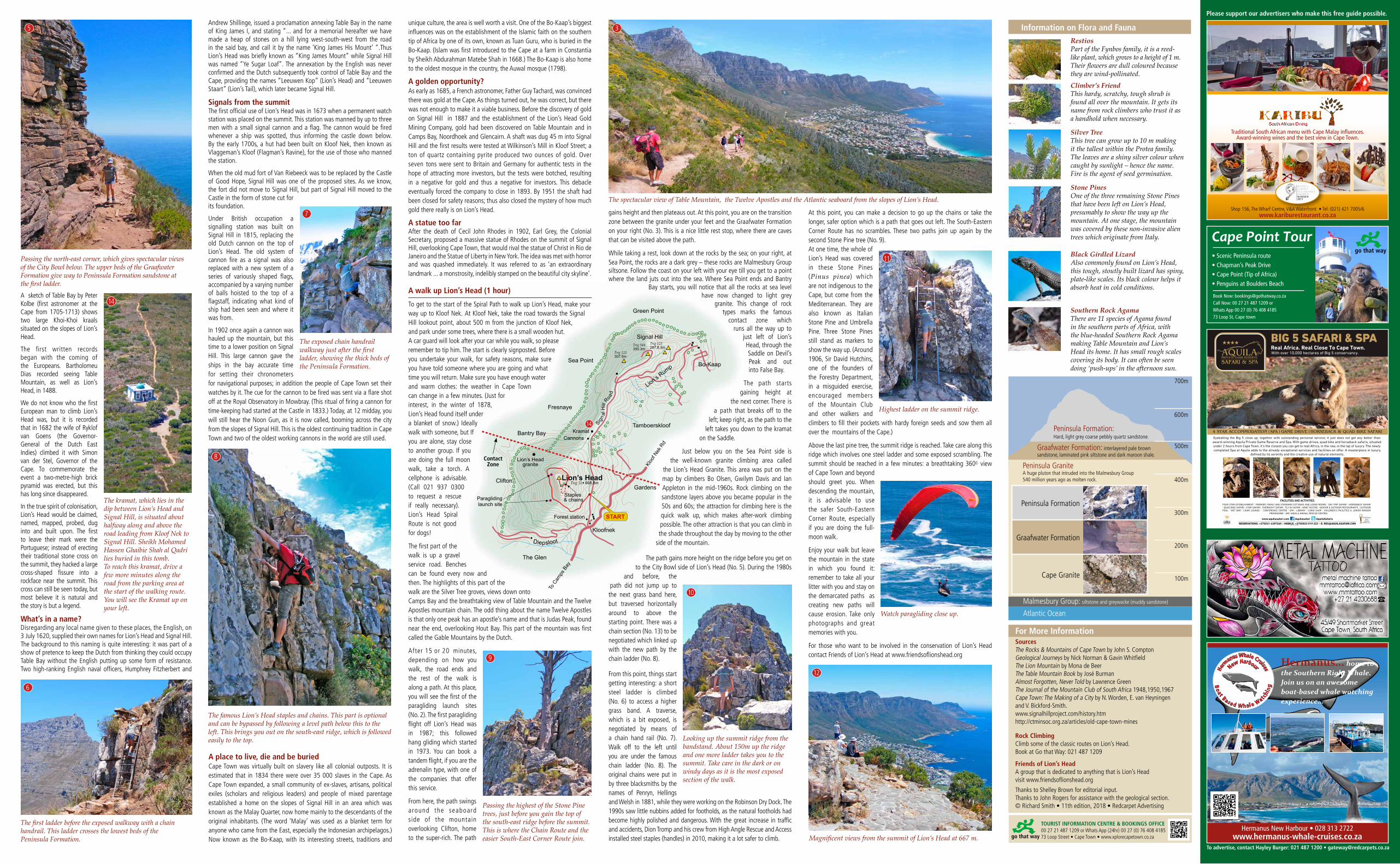
At this point, you can make a decision to go up the chains or take the longer, safer option which is a path that goes out left. The South-Eastern Corner Route has no scrambles. These two paths join up again by the second Stone Pine tree (No. 9).At one time, the whole of Lion’s Head was covered in these Stone Pines (Pinus pinea) which are not indigenous to the Cape, but come from the Mediterranean. They are also known as Italian Stone Pine and Umbrella Pine. Three Stone Pines still stand as markers to show the way up. (Around 1906, Sir David Hutchins, one of the founders of the Forestry Department, in a misguided exercise, encouraged members of the Mountain Club and other walkers and climbers to fill their pockets with hardy foreign seeds and sow them all over the mountains of the Cape.)
Above the last pine tree, the summit ridge is reached. Take care along this ridge which involves one steel ladder and some exposed scrambling. The summit should be reached in a few minutes: a breathtaking 3600 view of Cape Town and beyond should greet you. When descending the mountain, it is advisable to use the safer South-Eastern Corner Route, especially if you are doing the full-moon walk.
Enjoy your walk but leave the mountain in the state in which you found it: remember to take all your litter with you and stay on the demarcated paths as creating new paths will cause erosion. Take only photographs and great memories with you.
For those who want to be involved in the conservation of Lion’s Head contact Friends of Lion’s Head at www.friendsoflionshead.org
200
280
Signal HillTrig 544350.3m
Trig 122307.5m
Sign a
l Hill
Road
Lion’s Rump
Forest station
Diepsloot
Kloofnek
START
Bantry Bay
Fresnaye
Sea Point
Green Point
Bo-Kaap
Tamboerskloof
Gardens
The Glen
Clifton
Trig 125287.8.3m
Kramat
Lion’s HeadTrig 51• 668.8m
Cannons
Kloo
f Nek
Rd
To C
amps
Bay
Lion’s Headgranite
Paraglidinglaunch site
Staples & chains
A sketch of Table Bay by Peter Kolbe (first astronomer at the Cape from 1705-1713) shows two large Khoi-Khoi kraals situated on the slopes of Lion’s Head.
The first written records began with the coming of the Europeans. Bartholomeu Dias recorded seeing Table Mountain, as well as Lion’s Head, in 1488.
We do not know who the first European man to climb Lion’s Head was, but it is recorded that in 1682 the wife of Ryklof van Goens (the Governor-General of the Dutch East Indies) climbed it with Simon van der Stel, Governor of the Cape. To commemorate the event a two-metre-high brick pyramid was erected, but this has long since disappeared.
In the true spirit of colonisation, Lion’s Head would be claimed, named, mapped, probed, dug into and built upon. The first to leave their mark were the Portuguese; instead of erecting their traditional stone cross on the summit, they hacked a large cross-shaped fissure into a rockface near the summit. This cross can still be seen today, but most believe it is natural and the story is but a legend.
What’s in a name?Disregarding any local name given to these places, the English, on 3 July 1620, supplied their own names for Lion’s Head and Signal Hill. The background to this naming is quite interesting: it was part of a show of pretence to keep the Dutch from thinking they could occupy Table Bay without the English putting up some form of resistance. Two high-ranking English naval officers, Humphrey Fitzherbert and
For More InformationSourcesThe Rocks & Mountains of Cape Town by John S. ComptonGeological Journeys by Nick Norman & Gavin WhitfieldThe Lion Mountain by Mona de BeerThe Table Mountain Book by José BurmanAlmost Forgotten, Never Told by Lawrence GreenThe Journal of the Mountain Club of South Africa 1948,1950,1967Cape Town: The Making of a City by N. Worden, E. van Heyningenand V. Bickford-Smith.www.signalhillproject.com/history.htmhttp://ctminsoc.org.za/articles/old-cape-town-mines
Rock ClimbingClimb some of the classic routes on Lion’s Head.Book at Go that Way: 021 487 1209
Friends of Lion’s HeadA group that is dedicated to anything that is Lion’s Headvisit www.friendsoflionshead.org
Thanks to Shelley Brown for editorial input.Thanks to John Rogers for assistance with the geological section.© Richard Smith • 11th edition, 2018 • Redcarpet Advertising
Information on Flora and Fauna
.
700m
600m
500m
400m
300m
200m
100m
Peninsula Formation:Hard, light grey coarse pebbly quartz sandstone.
A huge pluton that intruded into the Malmesbury Group540 million years ago as molten rock.
Peninsula Granite
Malmesbury Group: siltstone and greywacke (muddy sandstone)
Atlantic Ocean
Graafwater Formation: interlayered pale brown sandstone, laminated pink siltstone and dark maroon shale.
Passing the north-east corner, which gives spectacular views of the City Bowl below. The upper beds of the Graafwater Formation give way to Peninsula Formation sandstone atthe first ladder.
The kramat, which lies in the dip between Lion’s Head and Signal Hill, is situated about halfway along and above the road leading from Kloof Nek to Signal Hill. Sheikh Mohamed Hassen Ghaibie Shah al Qadri lies buried in this tomb. To reach this kramat, drive a few more minutes along the road from the parking area at the start of the walking route. You will see the Kramat up on your left.
The first ladder before the exposed walkway with a chain handrail. This ladder crosses the lowest beds of thePeninsula Formation.
The famous Lion’s Head staples and chains. This part is optional and can be bypassed by following a level path below this to the left. This brings you out on the south-east ridge, which is followed easily to the top.
The spectacular view of Table Mountain, the Twelve Apostles and the Atlantic seaboard from the slopes of Lion’s Head.
Magnificent views from the summit of Lion’s Head at 667 m.
Southern Rock AgamaThere are 11 species of Agama found in the southern parts of Africa, with the blue-headed Southern Rock Agama making Table Mountain and Lion’s Head its home. It has small rough scales covering its body. It can often be seen doing ‘push-ups’ in the afternoon sun.
RestiosPart of the Fynbos family, it is a reed-like plant, which grows to a height of 1 m. Their flowers are dull coloured because they are wind-pollinated.Climber’s FriendThis hardy, scratchy, tough shrub is found all over the mountain. It gets its name from rock climbers who trust it asa handhold when necessary.
Silver TreeThis tree can grow up to 10 m making it the tallest within the Protea family. The leaves are a shiny silver colour when caught by sunlight – hence the name. Fire is the agent of seed germination.
Stone PinesOne of the three remaining Stone Pines that have been left on Lion’s Head, presumably to show the way up the mountain. At one stage, the mountain was covered by these non-invasive alien trees which originate from Italy.
Black Girdled LizardAlso commonly found on Lion’s Head, this tough, stoutly built lizard has spiny, plate-like scales. Its black colour helps it absorb heat in cold conditions.
5
14
7
8
6
9
10
12
11
3
14
Andrew Shillinge, issued a proclamation annexing Table Bay in the name of King James I, and stating “... and for a memorial hereafter we have made a heap of stones on a hill lying west-south-west from the road in the said bay, and call it by the name ‘King James His Mount’ “.Thus Lion’s Head was briefly known as “King James Mount” while Signal Hill was named “Ye Sugar Loaf”. The annexation by the English was never confirmed and the Dutch subsequently took control of Table Bay and the Cape, providing the names “Leeuwen Kop” (Lion’s Head) and “Leeuwen Staart” (Lion’s Tail), which later became Signal Hill.
Signals from the summitThe first official use of Lion’s Head was in 1673 when a permanent watch station was placed on the summit. This station was manned by up to three men with a small signal cannon and a flag. The cannon would be fired whenever a ship was spotted, thus informing the castle down below. By the early 1700s, a hut had been built on Kloof Nek, then known as Vlaggeman’s Kloof (Flagman’s Ravine), for the use of those who manned the station.
When the old mud fort of Van Riebeeck was to be replaced by the Castle of Good Hope, Signal Hill was one of the proposed sites. As we know, the fort did not move to Signal Hill, but part of Signal Hill moved to the Castle in the form of stone cut for its foundation.
Under British occupation a signalling station was built on Signal Hill in 1815, replacing the old Dutch cannon on the top of Lion’s Head. The old system of cannon fire as a signal was also replaced with a new system of a series of variously shaped flags, accompanied by a varying number of balls hoisted to the top of a flagstaff, indicating what kind of ship had been seen and where it was from.
In 1902 once again a cannon was hauled up the mountain, but this time to a lower position on Signal Hill. This large cannon gave the ships in the bay accurate time for setting their chronometers for navigational purposes; in addition the people of Cape Town set their watches by it. The cue for the cannon to be fired was sent via a flare shot off at the Royal Observatory in Mowbray. (This ritual of firing a cannon for time-keeping had started at the Castle in 1833.) Today, at 12 midday, you will still hear the Noon Gun, as it is now called, booming across the city from the slopes of Signal Hill. This is the oldest continuing tradition in Cape Town and two of the oldest working cannons in the world are still used.
A place to live, die and be buriedCape Town was virtually built on slavery like all colonial outposts. It is estimated that in 1834 there were over 35 000 slaves in the Cape. As Cape Town expanded, a small community of ex-slaves, artisans, political exiles (scholars and religious leaders) and people of mixed parentage established a home on the slopes of Signal Hill in an area which was known as the Malay Quarter, now home mainly to the descendants of the original inhabitants. (The word ‘Malay’ was used as a blanket term for anyone who came from the East, especially the Indonesian archipelagos.) Now known as the Bo-Kaap, with its interesting streets, traditions and
unique culture, the area is well worth a visit. One of the Bo-Kaap’s biggest influences was on the establishment of the Islamic faith on the southern tip of Africa by one of its own, known as Tuan Guru, who is buried in the Bo-Kaap. (Islam was first introduced to the Cape at a farm in Constantia by Sheikh Abdurahman Matebe Shah in 1668.) The Bo-Kaap is also home to the oldest mosque in the country, the Auwal mosque (1798).
A golden opportunity?As early as 1685, a French astronomer, Father Guy Tachard, was convinced there was gold at the Cape. As things turned out, he was correct, but there was not enough to make it a viable business. Before the discovery of gold on Signal Hill in 1887 and the establishment of the Lion’s Head Gold Mining Company, gold had been discovered on Table Mountain and in Camps Bay, Noordhoek and Glencairn. A shaft was dug 45 m into Signal Hill and the first results were tested at Wilkinson’s Mill in Kloof Street; a ton of quartz containing pyrite produced two ounces of gold. Over seven tons were sent to Britain and Germany for authentic tests in the hope of attracting more investors, but the tests were botched, resulting in a negative for gold and thus a negative for investors. This debacle eventually forced the company to close in 1893. By 1951 the shaft had been closed for safety reasons; thus also closed the mystery of how much gold there really is on Lion’s Head.
A statue too farAfter the death of Cecil John Rhodes in 1902, Earl Grey, the Colonial Secretary, proposed a massive statue of Rhodes on the summit of Signal Hill, overlooking Cape Town, that would rival the statue of Christ in Rio de Janeiro and the Statue of Liberty in New York. The idea was met with horror and was quashed immediately. It was referred to as ‘an extraordinary landmark ... a monstrosity, indelibly stamped on the beautiful city skyline’.
A walk up Lion’s Head (1 hour)
To get to the start of the Spiral Path to walk up Lion’s Head, make your way up to Kloof Nek. At Kloof Nek, take the road towards the Signal Hill lookout point, about 500 m from the junction of Kloof Nek, and park under some trees, where there is a small wooden hut. A car guard will look after your car while you walk, so please remember to tip him. The start is clearly signposted. Before you undertake your walk, for safety reasons, make sure you have told someone where you are going and what time you will return. Make sure you have enough water and warm clothes: the weather in Cape Town can change in a few minutes. (Just for interest, in the winter of 1878, Lion’s Head found itself under a blanket of snow.) Ideally walk with someone, but If you are alone, stay close to another group. If you are doing the full moon walk, take a torch. A cellphone is advisable. (Call 021 937 0300 to request a rescue if really necessary). Lion’s Head Spiral Route is not good for dogs!
The first part of the walk is up a gravel service road. Benches can be found every now and then. The highlights of this part of the walk are the Silver Tree groves, views down onto Camps Bay and the breathtaking view of Table Mountain and the Twelve Apostles mountain chain. The odd thing about the name Twelve Apostles is that only one peak has an apostle’s name and that is Judas Peak, found near the end, overlooking Hout Bay. This part of the mountain was first called the Gable Mountains by the Dutch.
After 15 or 20 minutes, depending on how you walk, the road ends and the rest of the walk is along a path. At this place, you will see the first of the paragliding launch sites (No. 2). The first paragliding flight off Lion’s Head was in 1987; this followed hang gliding which started in 1973. You can book a tandem flight, if you are the adrenalin type, with one of the companies that offer this service.
From here, the path swings around the seaboard side of the mountain overlooking Clifton, home to the super-rich. The path
gains height and then plateaus out. At this point, you are on the transition zone between the granite under your feet and the Graafwater Formation on your right (No. 3). This is a nice little rest stop, where there are caves that can be visited above the path.
While taking a rest, look down at the rocks by the sea; on your right, at Sea Point, the rocks are a dark grey – these rocks are Malmesbury Group siltsone. Follow the coast on your left with your eye till you get to a point where the land juts out into the sea. Where Sea Point ends and Bantry
Bay starts, you will notice that all the rocks at sea level have now changed to light grey
granite. This change of rock types marks the famous
contact zone which runs all the way up to
just left of Lion’s Head, through the Saddle on Devil’s Peak and out into False Bay.
The path starts gaining height at
the next corner. There is a path that breaks off to the
left; keep right, as the path to the left takes you down to the kramat
on the Saddle.
Just below you on the Sea Point side is the well-known granite climbing area called
the Lion’s Head Granite. This area was put on the map by climbers Bo Olsen, Gwilym Davis and Ian Appleton in the mid-1960s. Rock climbing on the sandstone layers above you became popular in the 50s and 60s; the attraction for climbing here is the quick walk up, which makes after-work climbing possible. The other attraction is that you can climb in the shade throughout the day by moving to the other
side of the mountain.
The path gains more height on the ridge before you get on to the City Bowl side of Lion’s Head (No. 5). During the 1980s
and before, the path did not jump up to the next grass band here, but traversed horizontally around to above the starting point. There was a chain section (No. 13) to be negotiated which linked up with the new path by the chain ladder (No. 8).
From this point, things start getting interesting: a short steel ladder is climbed (No. 6) to access a higher grass band. A traverse, which is a bit exposed, is negotiated by means of a chain hand rail (No. 7). Walk off to the left until you are under the famous chain ladder (No. 8). The original chains were put in by three blacksmiths by the names of Penryn, Hellings and Welsh in 1881, while they were working on the Robinson Dry Dock. The 1990s saw little nubbins added for footholds, as the natural footholds had become highly polished and dangerous. With the great increase in traffic and accidents, Dion Tromp and his crew from High Angle Rescue and Access installed steel staples (handles) in 2010, making it a lot safer to climb.
ContactZone
The exposed chain handrail walkway just after the first ladder, showing the thick beds of the Peninsula Formation.
Passing the highest of the Stone Pine trees, just before you gain the top of the south-east ridge before the summit. This is where the Chain Route and the easier South-East Corner Route join.
Highest ladder on the summit ridge.
Watch paragliding close up.
Looking up the summit ridge from the bandstand. About 150m up the ridge and one more ladder takes you to the summit. Take care in the dark or on windy days as it is the most exposed section of the walk.
Peninsula Formation
Graafwater Formation
Cape Granite
Please support our advertisers who make this free guide possible.
To advertise, contact Hayley Burger: 021 487 1200 • [email protected]
TOURIST INFORMATION CENTRE & BOOKINGS OFFICE00 27 21 487 1209 or Whats App (24hr) 00 27 (0) 76 408 418573 Loop Street • Cape Town • www.xplorecapetown.co.za
Shop 156, The Wharf Centre, V&A Waterfront • Tel: (021) 421 7005/6 www.kariburestaurant.co.za
Traditional South African menu with Cape Malay influences.Award-winning wines and the best view in Cape Town.
Cape Point Tour• Scenic Peninsula route• Chapman’s Peak Drive• Cape Point (Tip of Africa)• Penguins at Boulders Beach
Book Now: [email protected] Now: 00 27 21 487 1209 orWhats App 00 27 (0) 76 408 418573 Loop St, Cape town
Hermanus New Harbour • 028 313 2722www.hermanus-whale-cruises.co.za
Hermanus... home to the Southern Right Whale. Join us on an awesome boat-based whale watching experience...
New HarbourHerm
anus Whale Cruises
Bo
at Based Whale Watc
hin
g