pangean paleoclimate - jackson school of geosciences · during the pangean supercontinent. please...
TRANSCRIPT

Pangean Paleoclimate
By Erin Eastwood GEO 387H
November 18, 2008
Abstract
The Pangean supercontinent existed for more than 100 million years and had a profound
influence on Earth's climate and atmospheric circulation system. Proxy paleowind data from
aeolian (wind-blown) deposits in the rock record and climate models indicate a monsoonal
circulation system through the existence of Pangea. However, inconsistencies exist between
studies and the exact reconstruction of the monsoonal system remains unclear.
1. Introduction
Wind is integral to the Earth’s climate system and a major component of atmospheric
circulation. Historically, however, paleowind information has been under-utilized as input data
for ancient climate models. Aeolian (wind-blown) sand dunes are the most direct proxies for
paleowinds at the Earth’s surface because sand dunes form in direct response to the transport of
surface sediment by wind. Aeolian sand dunes provide direct evidence of atmospheric
circulation and the migration of dunes masks short-term climate variation and produces
paleowind information at a scale similar to global climate models (Blumberg and Greeley, 1996).
Where the study of dune fields is only feasible by remote and satellite images, aeolian systems
have been used to interpret the wind directions on Earth (Kocurek and Ewing, 2005; Beveridge
et al., 2006), Mars (Tsoar et al., 1979; Malin et al., 1998) and Titan (Lorenz et al., 2006).
Aeolian deposits are common in the ancient rock record and have been used for decades to infer
dune migration direction (e.g., Reiche, 1938; Curray, 1956; Poole, 1962; Peterson, 1988). More
detailed reconstructions of dune morphology and behavior from cross-strata have been used to
reconstruct wind regime (Rubin and Hunter, 1983; Kocurek et al., 1991; Crabaugh and Kocurek,
1993). Changes in wind directions within seasonal (e.g. monsoonal; Hunter and Rubin, 1983;
Erin Eastwood Pangean Paleoclimate Page 2

Chan and Archer, 1999; Loope et al., 2001) and daily cycles (Hunter and Richmond, 1988) have
been distinguished from aeolian cross-strata.
2. Pangea
The supercontinent Pangea dominated our planet for over 100 million years of Earth’s
history, from the Late Pennslyvanian to the Jurassic, with maximum extent during the Triassic.
This single continent stretched latitudinally across every part of the zonal atmospheric
circulation, thereby producing an extraordinary effect on the global paleoclimate (Dubiel et al.,
1991). The Permian-Triassic interval has been noted as a unique and extreme paleoclimate
interval due to the global occurence of red beds and evaporite deposits in numerous locations
world-wide (Dubiel et al., 1991; Glennie, 1987). During the Triassic the supercontinent was
approximately symmetric about the equator (Parrish and Peterson, 1988).
Approximately 2500m of aeolian-deposited sandstones accumulated in the south-western
United States during the time of the Pangea supercontinent, the majority of deposits occurring on
the Colorado Plateau (Blakey et al., 1988 (Figure 1). The Colorado Plateau is a modern highland
centered at the Four Corners region, or the geographic point where the states of Arizona, New
Mexico, Colorado and Utah meet. Peterson (1988) compiled paleowind data from cross-strata
within these eolian units, creating a dataset of dune migration directions spanning the Late
Pennsylvanian through Jurassic periods from which paleowind directions can be inferred.
Peterson's (1988) dataset is the largest paleowind data set covering any region or time in Earth’s
history (Loope et al., 2004). Using this data set with reconstructed Pangean paleogeography,
atmospheric circulation models can be used to predict the climate and atmospheric circulation
Erin Eastwood Pangean Paleoclimate Page 3

during the Pangean supercontinent. Please note that in this paper, all descriptions of wind
directions (e.g. north-westerly winds) refer to paleo-coordinates unless otherwise noted.
Figure 1. Paleogeographic map showing
the Colorado Plateau and Four Corners
region. Map by Ron Blakey.
http://jan.ucc.nau.edu/~rcb7/
3. Paleomagnetism
The polarity of the Earth’s magnetic field has repeatedly reversed orientations through
time. These reversals are recorded by iron-bearing minerals in igneous rocks that magnetize
parallel to the orientation of the Earth’s current magnetic field. Rocks forming today (e.g.
Atlantic Mid-Ocean Ridge basalts) contain magnetizations that match the current orientation of
the Earth’s magnetic field with magnetic north aligned with the North Pole. However, older
rocks contain magnetizations that are opposite, or reversed, from today’s orientation (Pitman and
Heirtzler, 1966). Rocks forming today at different latitudes are concordant with the modern
magnetic field. Likewise, Permian-aged rocks from various latitudes should all align with the
Erin Eastwood Pangean Paleoclimate Page 4
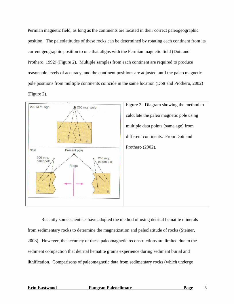
Permian magnetic field, as long as the continents are located in their correct paleogeographic
position. The paleolatitudes of these rocks can be determined by rotating each continent from its
current geographic position to one that aligns with the Permian magnetic field (Dott and
Prothero, 1992) (Figure 2). Multiple samples from each continent are required to produce
reasonable levels of accuracy, and the continent positions are adjusted until the paleo magnetic
pole positions from multiple continents coincide in the same location (Dott and Prothero, 2002)
(Figure 2).
Figure 2. Diagram showing the method to
calculate the paleo magnetic pole using
multiple data points (same age) from
different continents. From Dott and
Prothero (2002).
Recently some scientists have adopted the method of using detrital hematite minerals
from sedimentary rocks to determine the magnetization and paleolatitude of rocks (Steiner,
2003). However, the accuracy of these paleomagnetic reconstructions are limited due to the
sediment compaction that detrital hematite grains experience during sediment burial and
lithification. Comparisons of paleomagnetic data from sedimentary rocks (which undergo
Erin Eastwood Pangean Paleoclimate Page 5

compaction) and from igneous rocks (which do not compact) indicate that sedimentary rocks will
frequently yield paleolatitudes that are too low (Kent and Tauxe, 2005).
For Pangean paleogeographic reconstructions, traditional paleomagnetism methods have
reconstructed a steady northward migration of the supercontinent from Permian (5°N) through
Early Jurassic times (18°N) (Scotese, 1979 & 2003; Ziegler et al., 1997) (Figure 3). The total
error in the paleomagnetic data for the position of Pangea is approximately a few degrees of
latitude (Gibbs et al., 2002). Steiner (2003) used detrital hematite in Jurassic-age sedimentary
rocks to define the movement of the supercontinent, which yielded low Pangean paleolatitudes
(5-10°N) from the Early Permian through the Early Jurassic and migrating an additional 5°N
during the Middle Jurassic.
Figure 3. Paleogeographic map of Pangea. Note the unusual Eastern coastline and large
embayment. Map by Ron Blakey. http://jan.ucc.nau.edu/~rcb7/
Erin Eastwood Pangean Paleoclimate Page 6

4. Monsoonal Circulation
The Pangean climate has been described as “seasonal” since Daugherty (1941) and
“monsoonal” since Robinson (1973). An important feature of monsoonal circulation is cross-
equatorial flow, a product of the thermal and pressure contrast between the winter and summer
hemispheres (Dubiel et al., 1991). The modern Asian monsoon shows a 180° reversal of wind
directions between the winter and summer months (as defined for the northern hemisphere).
During the summer months southern hemisphere south-easterly trade winds blow over the Indian
and eastern Atlantic oceans, but as they reach the equator these winds turn abruptly and flow
south-westerly into low-pressure zones over India and West Africa (Loope et al., 2004) (Figure
4). During the winter months these winds are reversed, flowing north-easterly from Asia over
the Indian Ocean, turning abruptly to north-westerly winds as they reach the equator (Loope et
al., 2004) (Figure 4). The weakening of the Coriolis force at the equator allows this reversal of
wind directions to occur (Loope et al., 2004; Parrish and Peterson, 1988).
Erin Eastwood Pangean Paleoclimate Page 7

Figure 4. Diagram of the modern Asian monsoon, showing the cross-equatorial flow
characteristic of all monsoonal circulation systems. Bold arrows are westerly winds. Note that
in some locations, trade winds are reoriented to westerlies before crossing the equator. From
Loope et al. (2004).
Vertical circulation cells driven by sensible heating are key features of monsoons, and are
created by the thermal differences between oceans and continents. During early summer the
continents heat up more quickly than ocean waters, causing convection of warm air above the
continent. Humid, dense air over the cooler ocean water flows towards the area of low pressure
Erin Eastwood Pangean Paleoclimate Page 8

above the continent. Latent heat release plays an important role in maintaining the convection of
the monsoonal system (Dubiel et al., 1991).
Two dominant features of monsoonal circulation are 1) abundant, yet seasonal rainfall,
concentrated in the summer months, and 2) small annual temperature fluctuations (Dubiel et al.,
1991). A large indentation existed at the equator along the eastern side of Pangea (Figure 3),
setting up the ocean/land interface necessary for monsoonal climates. During the early stages of
Pangea development in the Late Carboniferous, a large mountain chain formed on the equator as
the result of continental collision. These mountains and the associated interior plateau may have
enhanced the monsoonal circulation, much as the Himalayas and the Tibetan Plateau influence
the modern Asian monsoon (Dubiel et al., 1991). However, due to their position on the equator,
these mountains may have hindered the monsoonal circulation (Rowley et al., 1985). If this was
indeed the case, full monsoonal circulation still would have been established in both hemispheres
by the Triassic, when Pangea had moved north and the mountains had begun to erode (Parrish
and Peterson, 1988).
5. Pangean Climate Models
Pangean atmospheric circulation models by Parrish and Peterson (1988) predict the
presence of a subtropical high-pressure cells off the northwest coast of Pangea and a monsoonal
low-pressure cell to the east of the supercontinent. The subtropical high-pressure cells are a
stable and long-lived component of atmospheric circulation that form as a result of land-sea
temperature differentials. Parrish and Peterson (1988) believe the summer winds were stronger
and more important than the winter winds for aeolian dune-field development, representing the
southeastern limb of a subtropical high-pressure (Parrish and Peterson, 1988). Larger summer
Erin Eastwood Pangean Paleoclimate Page 9

temperature differences produce stronger summer winds, which explains why the measured wind
directions of Peterson (1988) correspond best to the predicted summer winds as opposed to
winter winds (see next section) (Parrish and Peterson, 1988). It is possible that dune fields
located in the south-eastern portion of Pangea may have been influenced by summer monsoonal
circulation, particularly the Cedar Mesa Sandstone. Patzkowsky et al. (1991) modeled easterly
winter winds and northerly/northwesterly (summer monsoonal) winds for the Colorado Plateau
during the Early Permian.
Loope et al. (2004) cite several models of Pangean atmospheric circulation which predict
semi-arid equatorial zones and tropical westerlies (Gibbs et al., 2002; Chandler et al., 1992),
including a shift from subtropical north-easterlies to tropical north-westerlies at approximately
10°N of the equator. However, Chandler et al. (2002) caution that these monsoonal systems are
not the "megamonsoons" described by other authors (e.g., Dubiel et al., 1991), but instead are
associated with localized mid-latitude pressure cells located near the coast that are influenced by
topography and coastal geography. The monsoonal circulation patterns likely allowed the
development of semi-arid deserts at low latitudes, differing from the modern distribution of
semi-arid deserts located between 30°N and 30°S (Dubiel et al., 1991; Chandler et al., 2002).
Similarly, the modern African Sahara desert is located at low latitudes and is influenced by the
Asian monsoon (Loope et al., 2004).
Rowe et al. (2007) performed Early Jurassic climate simulations using the latest version
of the Community Climate System Model from the National Center for Atmospheric Research.
Simulations were performed using two paleogeography configurations: 1) the Colorado Plateau
is located at approximately 20°N, and 2) the Colorado Plateau is shifted to approximately 10°S
Erin Eastwood Pangean Paleoclimate Page 10

of the equator. This second configuration is used to fit with the conceptual monsoonal climate
model that Rowe et al. (2007) have proposed for Pangea (see Section 8).
6. Early Permian Wind Data, Colorado Plateau
The direction of Early Permian sediment transport in south-eastern Utah, derived from
aeolian cross-strata, indicates winds generally blew towards the southeast (present coordinates)
(Peterson, 1988). Throughout the Pennsylvanian-Middle Jurassic the winds on the Colorado
Plateau generally blew towards the southwest, south, or southeast (present coordinates)
(Peterson, 1988; Dubiel et al., 1991; Loope et al., 2001). These measured winds correspond with
the predicted summer subtropical circulation from circulation models, except during the Triassic
when monsoon circulation was at a maximum and influenced wind patterns in the south-eastern
portion of western Pangea and the southern Colorado Plateau (Parrish and Peterson, 1988). The
winds shifted during the Late Jurassic and blew towards the northeast (present coordinates)
(Peterson, 1988). This counterclockwise shift in wind patterns likely records the northward
migration of western Pangea out of the subtropical circulation and into the belt of westerlies
(Peterson, 1988; Parrish and Peterson, 1988).
Eolian dust, or loess deposits, can serve as proxy indicators of aridity and wind direction,
although they lack information about wind intensity and velocity due to the small size and
density of the particles (Soreghan, 1992). Loess commonly records high-resolution evidence of
terrestrial climate and climate change (Soreghan et al., 2002a). Pye (1987) documented modern
loess deposits that occur as a result of dry winds associated with either 1) depressions and cold
fronts, or 2) monsoonal circulation, specifically circulation downwind of moist monsoon
systems.
Erin Eastwood Pangean Paleoclimate Page 11

Soreghan et al. (2002b) inferred Early Permian (Wolfcampian) paleowinds by using U-Pb
detrital-zircon geochronology and determining the provenance (i.e. source location) of detrital
zircons from loess deposits in New Mexico and south-eastern Utah. The New Mexico samples
contain zircons derived from the Ancestral Rocky Mountains to the west, and zircons derived
from the Appalachian-Ouachita-Marathon Uplift to the east. The Utah samples contain zircons
derived from the western Mojave terrane located near present-day California and Arizona border
(Soreghan et al., 2002b). Results indicate that New Mexico experienced both westerly and
easterly paleowinds. Meanwhile, results indicate that Utah experienced unidirectional westerly
winds. It is likely that the high topography of the Ancestral Rocky Mountains acted as a wind
block, sheltering south-eastern Utah from the easterly winds recorded in New Mexico (Soreghan
et al., 2002b). These results are consistent with the predictions from Pangean climate models
and paleowind data from aeolian deposits.
The Cedar Mesa Sandstone is an Early Permian (Wolfcampian) succession of wind-
blown, eolian strata exposed in south-eastern Utah (Figure 5). The Cedar Mesa Sandstone is a
member of the Cutler Group and the distal, arid component of a fluvial system draining the
Uncompahgre Uplift (Mountney, 2006) (Figure 6). Peterson (1988) indicates that northwesterly
winds were responsible for development of the Cedar Mesa Dune Field. The Cedar Mesa
Sandstone consists of vertically-stacked sequences of eolian deposits, each separated by an
erosional surface. Loope (1985) proposed that these cycles of deposition and erosion (i.e. arid
and humid times) were caused by regionally-extensive cyclical changes in climate, possibly
driven by a glacio-eustatic mechanism. The Cedar Mesa Sandstone contains very few deposits
of evaporite minerals, indicating that the prevailing paleoclimate was relatively humid and rates
Erin Eastwood Pangean Paleoclimate Page 12

of surface evaporation did not exceed rates of ground water recharge via precipitation or local
fluvial input (Mountney, 2006).
Figure 5. Paleogeographic map for Early
Permian (Wolfcampian) showing dune
migration "tadpoles", where the tail points
downwind. The large arrows indicate
wind patterns predicted from the climate
model of Parrish and Peterson (1988).
From Peterson (1988).
Figure 6. Location of
Early Permian Cedar
Mesa Sandstone
outcrops, arrows
represent inferred
direction of paleowind
from aeolian cross-strata.
Modified from Mountney
(2006).
Erin Eastwood Pangean Paleoclimate Page 13

Soreghan et al. (2002a) identified paleosols and loessites in the Early Permian
(Wolfcampian) Lower Cutler beds from the south-western Paradox Basin that record a long-term
transition from semiarid conditions during the Late Pennsylvanian to seasonally wet conditions
during the Early Permian. Soreghan et al. (2002a) believe this climate transition represents
intensification of the Pangean monsoonal circulation, with the moisture increase resulting from
the seasonal presence of westerly winds. The vertical succession of paleosols and loessites
record high-frequency fluctuations between dry glacial periods and wet interglacial periods, with
increased sediment transport by wind during the glacial periods.
7. Pangean Paleoclimate Interpretations
Parrish and Peterson (1988) used the paleogeography results obtained from Scotese
(1979) and the paleowind data from Peterson (1988) to interpret the dominant western equatorial
Pangean winds as mid-latitude northern hemisphere anticyclones. Loope et al. (2004) used the
detrital hematite paleomagnetism from Steiner (2003) and paleolatitudes inferred from aeolian
cross-strata in Peterson (1988) to interpret the dominant winds in the Pangean Colorado Plateau
as tropical north-westerlies that seasonally blew across the equator, rather than the subtropical
anti-cyclones interpreted by Parrish and Peterson (1988), Dubiel et al., (1991), Loope et al.,
(2001).
Rowe et al. (2007) interpreted the aeolian cross-strata from Peterson (1988) as
representing two different circulation belts within Pangea's monsoonal system. The northern
portion of the Colorado Plateau records northeasterly trade winds, while the southern portion of
the Colorado Plateau rocks show northwesterly winds, or a belt of tropical westerlies located
equator-ward of the trade winds (Figure 7) (Rowe et al., 2007). Rowe et al. (2007) recognize
Erin Eastwood Pangean Paleoclimate Page 14

that the detrital hematite paleomagnetism methods used in Loope et al. (2004) are incorrect,
while the traditional paleomagnetism methods are correct. This means that western equatorial
Pangea and the Colorado Plateau were located near/at the equator during the Permian, and
migrated steadily northward to approximately 20°N by the Early Jurassic (Peterson, 1988;
Scotese, 1979 & 2003).
Figure 7. Dune dip directions for Early Permian (left) and Early Jurassic (right) aeolian
sandstones. Each "tadpole" represents at least 20 dune dip measurements, and the tails point
downwind. The large gray arrows show the flow of trade winds (upper arrows) and tropical
westerlies (bottom arrows). From Rowe et al. (2007).
Rowe et al. (2007) recognize that their interpretation of two circulation belts (trade winds
and tropical westerlies) could not have occurred at 20°N. They reason that in order for their
climactic belt interpretation to be plausible, western equatorial Pangea must been located at or
just south of the equator, where the northwesterly winds inferred from aeolian cross-strata in the
southern Colorado Plateau represent cross-equatorial flow induced by strong summer monsoonal
Erin Eastwood Pangean Paleoclimate Page 15
circulation in the southern hemisphere (Rowe et al., 2007). Rowe et al. (2007) cite "basic
qualitative concepts of climate" and climate model results as evidence that the Colorado Plateau
must have been situated on or south of the equator between Permian and Jurassic times, despite
long-standing paleomagnetism data that states otherwise. Rowe et al. (2007) present results of
the climate simulations that show a low pressure cell in the summer hemisphere and a high
pressure cell in the winter hemisphere, regardless of the paleolatitude configuration used. Rowe
et al. (2007) state that the simulations which place the Colorado Plateau in the southern
hemisphere are the only simulations which produce northeasterly trade winds in the northern
hemisphere that turn and become northwesterly winds south of the equator. Rowe et al. (2007)
conclude by making the assumption that the wind patterns inferred from the aeolian cross-strata
is correct and stating that one of the three following possibilities must be true: 1) the
paleomagnetism-based paleolatitude reconstruction that show northward migration of the
Colorado Plateau from the equator (Permian) to 20°N (Early Jurassic) is incorrect, 2) Early
Jurassic circulation models that simulate a pattern of northeasterly winds north of the equator
turning abruptly to northwesterly winds just south of the equator as a result of monsoonal
circulation are incorrect, or 3) the circulation pattern recorded by aeolian cross-strata within the
Pangean supercontinent represent an extreme climatic state that is far removed from anything we
have experienced or previously reconstructed from historical proxy data.
8. Discussion
Rowe et al. (2007) make the assumption that their interpretation of the paleowinds and
inferred dune migration directions from aeolian cross-strata is correct. However, Peterson
(1988) warns that "random measurements throughout all or part of the eolian formation are what
Erin Eastwood Pangean Paleoclimate Page 16

is mostly available in the literature, and a reevaluation based on more involved studies must,
perforce, await future work" (p. 209). Peterson (1988) also cautions that "that statistical
treatment of the [wind direction] data by rose diagrams and summary resultants may be an
oversimplification that can be misleading" (p. 210). Perhaps the paleomagnetism data is not
incorrect as Rowe et al. (2007) seem to suggest, but in fact, the interpretations of wind directions
from Peterson's (1988) data set have been oversimplified and do not accurately represent the
complexities in the ancient wind regimes.
9. Conclusions
Wind is an integral component of atmospheric circulation and overall climate. Proxy
paleowind data can be inferred from aeolian deposits in the ancient rock record and used to
reconstruct the climate of the supercontinent Pangea. Pangea existed for over 100 million years,
from the Late Pennsylvanian through Jurassic, and the distribution of continents as one large
landmass had a profound effect on the climate. Pangean climate models and deposits from the
ancient rock record indicate a monsoonal circulation, yet inconsistencies exist between studies
and the exact reconstruction of the circulation system remains uncertain. A more detailed
examination of aeolian cross-strata is needed to correctly infer the Pangean paleowinds; the
orientation of dunes needs to be taken into account when measuring the dune dip direction.
Erin Eastwood Pangean Paleoclimate Page 17

10. References Cited Beveridge, C., Kocurek, G., and Ewing, R.C., (2006). Development of spatially diverse and complex
dune-field patterns: Gran Desierto Dune Field, Sonoroa, Mexico. Sedimentology 53: 1391-1409. Blakey, R.C., Peterson, F., and Kocurek, G., (1988). Synthesis of late Paleozoic and Mesozoic eolian
deposits of the Western Interior of the United States, in: Kocurek, G. ed. Sedimentary Geology 56: 3-126.
Blumberg, D.G., and Greeley, R., (1996). A comparison of general circulation model predictions to sand drift and dune orientations. J. Clim 9: 3248.
Chan, M.A., and Archer, A.W., (2000). Cyclic eolian stratification on the Jurassic Navajo Sandstone, Zion National Park: periodicities and implications for paleoclimate. in: Sprinkel, D.A., Chidsey, Jr., T.C., and Anderson, P.B. eds. Utah Geological Association Publication 28: 1-11.
Chandler, M., Rind, D., and Ruedy, R. (1992). Pangean climate during the Early Jurassic: GCM simulations and the sedimentary record of paleoclimate. Bull. Geol. Soc. Am. 104: 543-559.
Crabaugh, M., and Kocurek, G., (1993). Entrada Sandstone: an example of a wet aeolian system. in: Pye, K., London Geological Society Special Publication 72: 103-126.
Curray, J.R., (1956). The analysis of two-dimensional orientation data. Journal of Geology 64: 117-131. Daugherty, L.H. (1941). The Upper Triassic flora of Arizona. Carnegie Institute of Washington Publ.
526: 108p. Dott, R.H., and Prothero, D.R. (2002). Evolution of the Earth, sixth edition. McGraw Hill, Boston. Dubiel, R.F., Parrish, J.T., Parrish, J.M. and Good, S.C. (1991). The Pangean megamonsoon: evidence
from the Upper Triassic Chinle Formation. Palaios 6: 347-370. Glennie, K.W. (1987). Desert sedimentary environments, present and past – a summary. Sedimentary
Geology 50: 135-165. Gibbs, M.T., Rees, P.M., Kutzbach, J.E., Ziegler, A.M., Behling, P.J., and Rowley, D.B. (2002).
Simulations of Permian climate and comparisons with climate-sensitive sediments. J.Geol. 110: 33-55.
Hunter, R.E., and Richmond, B.M., (1988). Daily cycles in coastal dunes. Sedimentary Geology 55: 43-67.
Hunter, R.E., and Rubin, D.M., (1983). Interpreting cyclic crossbedding, with an example from the Navajo Sandstone. in Brookfield ME, Ahlbrandt TS eds. Developments in Sedimentology: Eolian Sediments and Processes 38: 429-454.
Kent, D.V., and Tauxe, L., (2005). Science 307: 240. Kocurek, G., Knight, J., and Havholm, K.G., (1991). Outcrop and semi-regional three-dimensional
architecture and reconstruction of a portion of the eolian Page Sandstone (Jurassic). SEPM Concepts in Sedimentology and Paleontology 3: 25-43.
Kocurek, G., and Ewing, R.C., (2005). Aeolian dune field self-organization – implications for formation of simple versus complex dune-field patterns. Geomorphology 72: 94-105.
Loope, D.B., (1985). Episodic deposition and preservation of eolian sands – a late Paleozoic example from southeastern Utah. Geology 13: 73-76.
Loope, D.B., Rowe, C.M., and Joeckel, R.M., (2001). Annual monsoon rains recorded by Jurassic dunes. Nature 412: 64.
Loope, D.B., Steiner, M.B., and Rowe, C.M., (2004). Tropical westerlies over Pangean sand seas. Sedimentology 51: 315-322.
Lorenz, R.D., Wall. S., Radebaugh, J., Boubin, G., Reffet, E., Janssen, M., Stofan, E., Lopes, R., Kirk, R., Elachi, C., Lunine, J., Mitchell, K., Paganelli, F., Soderblom, L., Wood, C., Wye, L., Zebker, H., Anderson, Y., Ostro, S., Allison, M., Boehmer, R., Callahan, P., Encrenaz, P. Ori, G.G., Francescetti, G., Gim, Y., Hamilton, G., Hensley, S., Johnson, W., Kelleher, K., Muhleman, D., Picardi, G., Posa, F., Roth, L., Seu, R., Shaffer, S., Stiles, B., Vetrella, S., Flamini, E., and West, R., (2006). The sand seas of Titan: Cassini RADAR observations of longitudinal dunes. Science 312: 724-727.
Erin Eastwood Pangean Paleoclimate Page 18
Malin, M.C., Carr, M.H., Danielson, G.E., Davies, M.E., Hartmann, W.K., Ingersoll, A.P., James, P.B., Masursky, H., McEwen, A.S., Soderblom, L.A., Thomas, P., Veverka, J., Caplinger, M.A., Ravine, M.A., Soulanille, T.A., and Warren, J.L., (1998). Early views of the Martian surface from the Mars Orbiter Camera of Mars Global Surveyor. Science 279: 1681-1685.
Mountney, N.P., (2006). Periodic accumulation and destruction of aeolian erg sequences in the Permian Cedar Mesa Sandstone, White Canyon, southern Utah, USA. Sedimentology 53: 789-823.
Parrish, J.T., and Peterson, F., (1988). Wind directions predicted from global circulation models and wind directions determined from eolian sandstones of the western United States – a comparison. in: Kocurek, G. ed. Sedimentary Geology 56: 261-282.
Patzkowsky, M.E., Smith, L.H., Markwich, P.J., Engberts, C.J., and Gyllenhall, E.D. (1991). Application of the Fujita-Ziegler paleoclimatic model: Early Permian and Late Cretaceous examples. Palaeogeography, Palaeoclimatology, Palaeoecology 86: 67-85.
Peterson, F., (1988). Pennsylvanian to Jurassic eolian transportation systems in the western United States in: Kocurek, G. ed. Sedimentary Geology 56: 207-260.
Pittman and Heirtzler (1966). Science 154: 1166-1171. Poole, F.G., (1962). Wind directions in late Paleozoic to middle Mesozoic time on the Colorado Plateau.
U.S. Geol. Surv., Prof. Pap., 450-D: D147-D151. Pye, K., (1987). Aeolian dust and dust deposits: London, Academic Press, 334 p. Reiche, P., (1938). An analysis of cross-lamination, the Coconino Sandstone. Journal of Geology 46: 905-
932. Robinson, P.L. (1973). Paleoclimatology and continental drift: in Tarling, D.H., and Runcorn, S.K. eds.
Implications of Continental Drift to the Earth Sciences, I: Academic Press, London, p. 449-476. Rowe, C.M., Loope, D.B., Oglesby, R.J., Van der Voo, R., and Broadwater, C.E., (2007). Inconsistencies
between Pangean reconstructions and basic climate controls. Science 318: 1284-1286. Rowley, D.B., Raymond, A., Parrish, J.T., Lottes, A.L., Scotese, C.R., and Ziegler, A.M, (1985).
Carboniferous paleogeographic, phytogeographic, and paleoclimatic reconstructions. Int. J. Coal. Geol., 5: 7-42.
Rubin, D.M., and Hunter, R.E., (1983). Reconstructing bedform assemblages from compound crossbedding. in Brookfield, M.E., and Ahlbrandt, T.S., ed. Developments in Sedimentology 38: 407-428.
Scotese, C.R., Bambach, R.K., Barton, C., Van der Voo, R., and Ziegler, A.M., (1979). Paleozoic base maps. J. Geol., 87: 217-277.
Scotese, C.R. (2003). PALEOMAP, Earth History, Jurassic. URL http://www.scotese.com/Jurassic.htm (November 2008).
Soreghan, G.S. (1992). Preservation and paleoclimatic significance of eolian dust in the Ancestral Rocky Mountains province. Geology 20: 1111-1114.
Soreghan, G.S., Elmore, R.D., and Lewchuck, M.T. (2002a). Sedimentologic-magnetic record of western Pangean climate in upper Paleozoic loessite (lower Cutler beds, Utah). Geol. Soc. Am. Bull. 114: 1019-1035.
Soreghan, M.J., Soreghan G.S., and Hamilton, M.A., (2002b). Paleowinds inferred from detrital-zircon geochronology of upper Paleozoic loessite, western equatorial Pangea. Geology 30: 695-698.
Steiner, M.B., (2003). Tectonics 22: 1020. Tsoar, H., Greeley, R., and Peterfreund, A.R., (1979). Mars –north polar sand sea and related wind
patterns. Journal Geophysical Research 84: 8167-8182. Ziegler, A.M., Hulver, M.L., and Rowley, D.B. (1997). Permian world topography and climate. In
Martini, I.P. ed. Late glacial and postglacial environmental changes: Pleistocene, Carboniferous-Permian, and Proterozoic. Oxford, Oxford University Press: 111-146.
Erin Eastwood Pangean Paleoclimate Page 19