pangborn memorial airport i one pangborn drive i east ... · program financial assistance from the...
TRANSCRIPT

Pangborn Memorial Airport I One Pangborn Drive I East Wenatchee, WA 98802
Phone: 509.884.2494 ext. 6 I Fax: 509.884.0113 I www.flywenatchee.com I www.pangbornairport.com
TO: Planning Advisory Committee (PAC) Members RE: Pangborn Airport Master Plan – Working Paper #1 DATE: August 25, 2016 Please find attached for your review the ‘draft’ Working Paper #1 documents for the Pangborn Airport Master Plan. These files includes the following:
Introduction Chapter Inventory/Environmental Overview Chapter Appendices PAC Packet / Meeting Agenda
Each of these materials will be reviewed at the August 31 PAC Meeting #1, with an opportunity for the PAC members to provide input and comment. Again, the PAC Meeting #1 is Wednesday, August 31, 2016, from 11:00 am to 1:00 p.m. at the Confluence Technology Center (285 Technology Center Way, Wenatchee). Lunch will be provided. We look forward to visiting with you, and starting this important Airport Master Plan study. In the meantime, please feel free to contact me at 509-884-2494 Ext. 6 or [email protected] if you have any questions. Sincerely,
Trent Moyers Airport Director Pangborn Memorial Airport

AIRPORT MASTER PLAN PANGBORN MEMORIAL AIRPORT (EAT)
2016
PRELIMINARY DRAFT REPORT – CHAPTER 1
(INTRODUCTION, INVENTORY/ENVIRONMENTAL OVERVIEW)
DRAFT: PUBLIC REVIEW
“The preparation of this document may have been supported, in part, through the Airport Improvement
Program financial assistance from the Federal Aviation Administration (AIP Project Number 3-33-0084-
038-2016) as provided under Title 49 U.S.C., Section 47104. The contents do not necessarily reflect the
official views or policy of the FAA. Acceptance of this report by the FAA does not in any way constitute a
commitment on the part of the United States to participate in any development depicted therein nor does
it indicate that the proposed development is environmentally acceptable or would have justification in
accordance with appropriate public laws.”
Port of Chelan County Officials
Mr. Donn Etherington, District #1
Ms. JC Baldwin, District #2
Mr. Rory Turner, District #3
Port of Douglas County Officials
Mr. Jim Huffman, District #1 Mr. Alan Loebsack, District #2 Mr. Mark Spurgeon, District #3
Airport Staff
Mr. Trent Moyers, Airport Director
Mr. Ron Russ, C.M. Operations Manager
Ms. Tina Stadther, Administrative Manager
Ms. Felicity Lape, Finance Specialist
Ms. Bobbie Chatriand, Administrative Assistant

INTRODUCTION
DRAFT

Pangborn Memorial Airport ____________________________________________________________________________________
____________________________________________________________________________________ Introduction: October 2016 - DRAFT i
INTRODUCTION
OVERVIEW
The Airport Master Plan (“Plan”) is being prepared by the Airport Sponsor to assess and document the facility
and service needs of the Pangborn Memorial Airport (“Airport”). The Plan serves as a roadmap for bringing
projects, people, and funding together in a coordinated manner, and provides strategic direction regarding the
Airport’s 20-year capital development plan and investment of resources. This Plan is funded by the Airport
Sponsor, with a grant from the Federal Aviation Administration’s (FAA) Airport Improvement Program (AIP)
and funds from the Passenger Facility Charge (PFC) program.
The Plan is prepared in accordance with FAA guidance, as prescribed by grant assurances and regulatory
standards. Conformance with FAA standards enables the Airport to apply for federal and state funding to
support the maintenance, expansion, and upgrade of Airport facilities.
1. PURPOSE
The overarching purpose of the Plan is to document the orderly development of airport facilities, services, and
equipment needs. The Plan describes and illustrates the Airport’s 20-year facility development needs, providing
the basis for justifying projects as recommended by the Airport Sponsor, tenants, users, and community
stakeholders. The Plan is reflective of input from the local community while providing for a facility that is:
• Safe and efficient, in accordance with FAA design standards.
• Economically viable and supported in a financially sustainable manner.
• Aligned with broad local, regional, state and national planning goals.
2. BACKGROUND
The Plan evaluates improvement needs with respect to up-to-date user information, trends, facility conditions,
and design standards. The Plan was last updated in 2004; however, changes in FAA design standards, activity
trends, and airport development goals mean that the 2004 Plan no longer reflects stakeholder needs. This
update to the Plan addresses activities conducted by commercial service, general aviation, and military users,
in addition to other aviation and non-aeronautical interests located on and off-Airport.

Pangborn Memorial Airport ____________________________________________________________________________________
____________________________________________________________________________________ Introduction: October 2016 - DRAFT ii
3. PLAN FOCUS
The Plan is principally used to identify future Airport facility needs and to resolve key planning issues. The
following items are the key actions addressed as part of this Plan:
• Crosswind Runway 7-25 Operational Justification and Length Requirements
• Resolve FAA Hotspots to Runway and Taxiway Geometry
• Address FAA Non-Standard Conditions on the Airport Layout Plan (ALP)
• Terminal Building Facility and Functional Needs
• Airline Market Potential and Opportunities
• On-Airport Revenues and Revenue Generation; Airport Rates and Charges
• General Aviation Service and Facility Needs
• Future Airport Landside Development and Roadway Access
• Future Airport Property Interests
• Future Airport Agricultural Leased Areas
• Update Airport Noise Contours
• Update ALP Per FAA Standards and Checklists
• Prepare 20-Year Airport Capital Development Plan
• Update 5-Year Airport Capital Improvement Program (CIP)
4. PLAN DOCUMENTATION
The following describes the core components of the Plan.
Narrative Report: The narrative report documents the Airport decision-making leading to the
recommendations depicted on ALP drawings and carried forward as part of the 20-year airport capital
development plan. The narrative is arranged per the following chapters.
• Chapter 1 – Inventory/Environmental Overview
• Chapter 2 – Aviation Demand Forecasts
• Chapter 3 – Facility Requirements
• Chapter 4 – Improvement Alternatives
• Chapter 5 – Implementation and Capital Improvement Plan
Airport Layout Plan Drawings: The final component of this Plan is the ALP, which is a set of drawings that
illustrate airport facilities and depict recommended improvements. The ALP drawings, which serve as the
Airport’s official ‘record of planning’, are developed in accordance with FAA checklist standards and procedural
requirements.

Pangborn Memorial Airport ____________________________________________________________________________________
____________________________________________________________________________________ Introduction: October 2016 - DRAFT iii
5. PLAN COORDINATION AND PARTICIPATION
The Plan’s public involvement process serves to inform and engage stakeholders such as community leaders,
businesses and interested residents, with the intent of incorporating public viewpoints into the plan. The
outreach includes public meetings conducted at key milestones, stakeholder briefing presentations, and
informational materials presented in various formats for public review. The purpose is to build an
understanding of the master planning process, and establish realistic expectations for what will be considered
and achieved. The following are the key public coordination and participation elements of the Plan:
Airport Stakeholders: The Plan involves coordination and input from multiple local governmental interests,
organizations, and constituencies. The following are key stakeholders that are engaged as part of the Plan:
• Port of Chelan County
• Port of Douglas County
• Airport Users and Services Providers
Planning Advisory Committee (PAC): A PAC was established specifically for this Plan because plans that involve
diverse community participation are more successful and widely accepted than those without. The PAC serves
in an ‘advisory’ capacity, comprised of airport and community stakeholders focused on guiding Plan
recommendations to reflect community interests. The PAC is charged with reviewing interim Plan materials,
attending PAC meetings, providing comment on Plan findings, and encouraging awareness and adoption of the
Plan recommendations in the communities that they represent. PAC feedback is incorporated, as appropriate,
into the final Plan.
Agency Coordination: The FAA is the lead agency for this Plan, and primarily involved with the review of Plan
documentation and formal approval of the aviation activity forecasts and ALP drawings. This coordination
facilitates dialogue as the Plan progresses, allowing the Airport and the FAA to communicate their shared
interests, and to mutually decide key Plan decisions that require FAA input. The Plan includes coordination with
local constituencies at key milestones.
Public Outreach and Participation: Public outreach is an important element of the public involvement process
and serves as the opportunity for the public-at-large to learn about the Plan progress, interact with
stakeholders, communicate concerns, and provide feedback. Public meetings are held at key project
milestones, and public insights and suggestions are integrated into the final Plan. Periodic project updates are
presented through fact sheets, newsletters, outreach events, social media outlets, and posted on the Airport
website.

Pangborn Memorial Airport ____________________________________________________________________________________
____________________________________________________________________________________ Introduction: October 2016 - DRAFT iv
6. STRATEGIC EVALUATION
As a strategic planning process, the Plan is structured to be responsive to the Airport Sponsor’s overall mission,
while being inclusive of broader community needs. The Airport is one of the community’s most important
economic assets, and scheduled commercial air service is of paramount importance to residents and businesses
in Chelan and Douglas counties. The Airport Sponsor, as a Port entity, has the mission to maintain multi-modal
transportation assets and long-term infrastructure, such as the Airport, and charged with spurring economic
development, creating jobs, expanding the region’s tax base, and providing leadership for diverse economic
growth. As part of the strategic planning process, a Strengths, Weaknesses, Opportunities and Threats (SWOT)
analysis is conducted with the PAC to determine the appropriate strategic visions for the Airport, and specific
goals and objectives to be addressed throughout the Plan. SWOT is a process for synchronizing strategic
decision-making factors, and helps categorize the Airport's internal and external characteristics, qualities, and
merits. When compiled, the SWOT factors help formulate Plan goals, provide the basis to pragmatically assess
recommendations, and guide the Plan’s overall developmental policy.
Helpful Harmful
Positive To Achieving
the Objective
Negative To Achieving
the Objective
Inte
rna
l O
rig
in
Attri
bu
tes W
ith
in
Air
port
In
flu
en
ce
Strengths Weaknesses
Ex
tern
al O
rig
in
Attri
bu
tes B
eyo
nd
Air
po
rt In
flu
en
ce
Opportunities Threats
Opportunities:
Threats:
Controlled potential benefit to exploit or capitalize.
Uncontrollable potential vulnerability, risk, or detriment.
SWOT TABLE
Strengths: Advantageous quality.
Weaknesses: Disadvantage or deteriorating influence.

Pangborn Memorial Airport ____________________________________________________________________________________
____________________________________________________________________________________ Introduction: October 2016 - DRAFT v
Strengths:
1. Airport vital to community’s economic well-being
2. Supportive community
3. Airport growing
4. 7,000’ Runway 12-30 length
5. 150’ Runway 12-30 width
6. Regional service area - Central Washington location
7. Regional location to connect with surrounded Seattle, Pasco, and Spokane
8. Proximity to Wenatchee/Quincy
9. Quality scheduled airline service with Alaska Airlines
10. Highly capable Airport management and operations staff
11. Efficient security/TSA experience
12. Easy and affordable airline auto parking
13. Location of Airport provides extraordinary gliding opportunities
14. Location/access to industrial, commercial, and residential areas
15. Vacant, available land with airfield access and other supportive uses
16. Airport industrial land for private development and for Port lease
17. Space to grow on Port-managed property
Weaknesses:
1. Lack of services near the Airport; including hotel and gas station
2. Absence of a crosswind runway
3. Ramp pavement condition
4. Leverage with airline(s)
5. Aircraft fueling availability
6. Wintertime and weather reliability; schedule reliability due to instrument approach standards (currently
the minimum requirement is 1- mile visibility and 300-foot high cloud cover ceiling). This is a huge
improvement over the past but it might be improved more
7. Pavement condition
8. Lack of adequate utilities and access
9. Airport operates at financial loss
10. Cost of operation
11. Financial sustainability; Airport operating deficits; limited ability to fund Airport projects
12. Helicopter parking areas
13. Airline passenger pickup
14. Lack of available terminal area space
15. Limited Airport land base

Pangborn Memorial Airport ____________________________________________________________________________________
____________________________________________________________________________________ Introduction: October 2016 - DRAFT vi
16. Airport land size limits ability to generate non-aviation revenue
Opportunities:
1. Growth in area around Airport
2. Growing local population; demographic changes with baby boomers and millennials
3. Collaborative partners willing to participate in supporting the Airport
4. Marketing to neighbor cities
5. Ground transportation to surrounding communities – Chelan, Leavenworth, Quincy, Methow Valley
6. New airline service; flight frequency, additional direct airline flights to other destinations
7. Increased enplanements/load factor
8. Air package services
9. Advertising to increase passenger numbers
10. Growing tourism/outdoor recreation opportunities; now on the radar
11. Highlight local attractions at Airport
12. Air tourism – rides
13. More aviation-related/dependent business
14. Surrounding industrial lands
15. Real estate development (business park)
16. Business development is more general aviation; and now commercial use
17. Executive Flight building
18. General aviation maintenance
19. New hangar space
Threats:
1. Ground transportation to surrounding communities – Chelan, Leavenworth, Quincy, Methow Valley
2. Drive proximity to Seattle-Tacoma International Airport (SEA)
3. Limited airline flight frequency to-and-from Seattle (SEA)
4. Limited airline destinations; consider California
5. Airline flight timing – connections
6. Controlling land uses surrounding the Airport
7. Encroachment of incompatible land uses (housing) translates into actual conflicts, complaints
8. Aircraft non-movement areas
9. Regional competition
10. Pilot shortage
11. Flight cancellations due to weather
12. Loss of commercial airline service
13. Reduced convenience for travelers

Pangborn Memorial Airport ____________________________________________________________________________________
____________________________________________________________________________________ Introduction: October 2016 - DRAFT vii
14. Ridership changes; other transport options – shuttle/rail/drive
15. Declining general aviation sector
16. Wenatchee terrain; limits approach minimums -- ability to change or improve
17. Passenger levels and the ability to justify more scheduled airline service
CHAPTER 1
DRAFT
AIRPORT INVENTORY AND
ENVIRONMENTAL OVERVIEW (WORKING PAPER #1)

Pangborn Memorial Airport ____________________________________________________________________________________
____________________________________________________________________________________ Inventory Chapter: October 2016 - DRAFT 1
AIRPORT INVENTORY CHAPTER
CHAPTER OVERVIEW
The inventory documents the Pangborn Memorial Airport’s (“Airport”) facilities, services, and conditions used
to establish the informational basis for recommendations made throughout the Airport Master Plan (“Plan”).
Project information was collected through a review of Airport records, published data, and interviews
conducted as part of on-site inspections to verify the status and condition of Airport facilities.
The Inventory Chapter is arranged in the following sections:
1. Airport Overview
2. Airfield and Airspace Facilities
3. Terminal / Landside Facilities and Support Services
4. Meteorological Conditions
5. Airport Land Use and Regulations
6. Airport Economic Profile
7. Environmental Overview
8. Financial Overview
9. Inventory Chapter Summary
1. AIRPORT OVERVIEW
This Section provides an understanding of the Airport’s operational characteristics.
1.1 AIRPORT LOCATION
Exhibit 1.1 illustrates the Airport location and geographic proximity in relation to surrounding roadways,
population centers, and city limits. The Airport is located in unincorporated Douglas County, situated southeast
of the cities of Wenatchee and East Wenatchee. The Airport’s primary roadway access is along an east-west
corridor, via Grant Road.
1.2 AIRPORT GOVERNANCE
The Airport is owned jointly by the Port of Chelan County and the Port of Douglas County. The Ports operate
and manage the Airport under a Joint Operating Agreement, which establishes an Airport Governing Board for
providing administrative oversight. The day-to-day operations are managed by a full-time Airport Director and
supporting staff, reporting to the Governing Board.

Pangborn Memorial Airport ____________________________________________________________________________________
____________________________________________________________________________________ Inventory Chapter: October 2016 - DRAFT 2
EXHIBIT 1.1: AIRPORT LOCATION & VICINITY
1.3 AIRPORT ROLE AND CLASSIFICATION
Table 1.1 describes the key Airport facility and operational attributes. The Airport is a public-use facility
accommodating scheduled commercial airline passenger service, commercial air cargo, general aviation, and
military activity. The Airport is included in the Federal Aviation Administration’s (FAA) National Plan of
Integrated Airport Systems (NPIAS) and classified as a primary non-hub commercial service facility, thus making
the Airport eligible to receive Federal Airport Improvement Program (AIP) grants. The Airport is certified by
the FAA as a Class I FAA Part 139 facility, which means that it maintains facilities and services intended to serve
scheduled passenger aircraft with 30 or more passenger seats.
The Washington State Department of Transportation (WSDOT) classifies the Airport as a ‘Commercial Service’
facility, and is designated as an “Essential Public Facility” pursuant to Revised Code of Washington 36.70A.200.
The airfield facilities are intended to accommodate an aircraft fleet representative of narrow-body commercial
jet transports and medium to large-cabin general aviation business jets.

Pangborn Memorial Airport ____________________________________________________________________________________
____________________________________________________________________________________ Inventory Chapter: October 2016 - DRAFT 3
TABLE 1.1: AIRPORT OVERVIEW
Note: See Appendix for list of acronyms.
Sources: FAA Publications and Airport Records Obtained June, 2015.
1.4 AIRPORT AVIATION ACTIVITY
Activity Overview
In 2015, the Airport processed approximately 120,000
airline passengers (62,000 enplaned passengers),
experienced 40,700 aircraft operations, and is the
domicile for 104 based aircraft. Aircraft operational
traffic, as a non-towered facility, are estimates as
obtained from FAA published records. The Airport is the
6th busiest commercial service airport in the State of
Washington.
Airport Activity/Runway Utilization
Table 1.2 summarizes operational activity as conducted by user category, operational type, and runway end.
Of the total 40,749 annual aircraft operations, nearly 6,000 are commercial air carrier and cargo operations (15
percent) and 35,000 (85 percent) general aviation operations. Itinerant operations account for nearly 40
percent of the traffic and local operations 60 percent, with local traffic attributed largely to US Forest Service
firefighting activities. Wind data suggests that Runway 30 captured about 75 percent of arrival and departure
traffic, and Runway 12 about 25 percent.
Airport Attributes Description
Airport Owner Port of Chelan County and Port of Douglas County
Primary Commercial Service (Non-Hub)
Site Number: 26461.A
FAA Part 139 Certification Class 1
FAA Part 139 ARFF Index Category ‘A’
FAA Airport Reference Code C-III
Critical / Demanding Aircraft Bombardier Q400 Turboprop
WSDOT Airport Category Commercial Service
Airport Traffic Control Tower None
Airport Property 698 Acres (Total Fee)
Navigational Aids ILS, RNAV (RNP), VOR/DME
Automated Weather Station Automated Surface Weather Observation Service (ASOS)
Approach/Departure Control (Seattle ARTCC)
Remote Communications Outlet
FAA NPIAS Airport Classification
Communications
Airline Passenger Enplanements: The count of
passengers (revenue and non-revenue) boarding
a scheduled commercial flight; excludes pilot and
crew members.
Aircraft Operations: The count of aircraft
takeoffs and landings, classified as local (aircraft
took off and landed at the same airport) and
itinerant (aircraft took off and landed at different
airports).
Based Aircraft: Aircraft stored in hangars or on
tie-downs; excludes temporary visiting aircraft or
registered at another airport.

Pangborn Memorial Airport ____________________________________________________________________________________
____________________________________________________________________________________ Inventory Chapter: October 2016 - DRAFT 4
TABLE 1.2: AIRPORT ACTIVITY SUMMARY (2015 BASELINE YEAR)
Note: Traffic estimated from Airport data provided to FAA. Percent runway arrival and departure traffic estimated from wind
data information in consideration of users, aircraft size and operating conditions. Closed crosswind Runway 7-25 excluded.
Source: FAA published data, Airport activity records, Wind observation data, Airport Staff estimates (July 2016).
The following summarizes activity by user category:
Scheduled Airline: Commercial airline service is provided by Alaska Airlines using the 76-seat Bombardier
Q400 turboprop aircraft, operating up to three daily nonstop flights to the Seattle-Tacoma International Airport
(SEA). In 2015, Alaska Airlines conducted 2,200 aircraft arrival and departure operations, carried 120,175 total
passengers, with monthly enplanements ranging from 8,000 to 11,300 passengers.
Scheduled Air Cargo: Air cargo is conducted by three carriers, including Empire Airlines (contracted by FedEx),
Ameriflight (contracted by UPS), and Alaska Airlines, each operating propeller aircraft including the Beechcraft
Model 99, Swearingen Merlin 3, Fairchild Dornier SA-227DC Metro, Cessna 208 Caravan, and the Bombardier
Q400. In 2015, the dedicated air cargo operator activity accounted for 2,950 annual aircraft operations and
totaled 1.27 million cargo pounds (freight, packages, mail) transported to and from the Airport.
General Aviation: General aviation accounts for nearly 35,000 annual operations, or 87 percent of the total
Airport traffic, as comprised of 90 percent by fixed-wing aircraft and 10 percent helicopters. Nearly 72 percent
of operations are conducted by piston-engine aircraft, 12 percent by turboprops, 6 percent by business jets,
and 10 percent helicopters. There are 104 based aircraft, including 82 single-piston engine, 6 multi-piston, 2
business jets, and 3 helicopters. There are 9 based sailplane gliders and 2 ultralights.
United States Forest Service (Firefighting) Activity: The US Forest Service (USFS), with an on-Airport
Central Washington Interagency Communications Center, engages in aerial firefighting, rescue/rappelling
activities, and multiple-agency fire dispatch services. The USFS conducts between 1,000 and 7,500 annual
operations, depending on the severity of the fire season. The peak fire season typically occurs between
mid-June and September. Although not permanently based at EAT, the USFS operates helicopter and fixed-
Operation ClassificationAirport
Total
Airport
Percent
Runway 12
(Operations)
Runway 12
(%)
Runway 30
(Operations)
Runway 30
(%)
TOTAL 40,749 100% 9,894 24.3% 30,855 75.7%
Operation Type
Itinerant Operation 15,628 38.4% 3,614 23.1% 12,015 76.9%
Scheduled Air Carrier 2,030 5.0% 406 20.0% 1,624 80.0%
Other Commercial/Cargo 3,840 9.4% 768 20.0% 3,072 80.0%
General Aviation 9,658 23.7% 2,415 25.0% 7,244 75.0%
Military 100 0.2% 25 25.0% 75 75.0%
Local Operations 25,121 61.6% 6,280 25.0% 18,841 75.0%
General Aviation 25,121 61.6% 6,280 25.0% 18,841 75.0%
Military 0 0.0% 0 0.0% 0 0.0%

Pangborn Memorial Airport ____________________________________________________________________________________
____________________________________________________________________________________ Inventory Chapter: October 2016 - DRAFT 5
wing aircraft, commonly the Bell 204/205/206/210, Kaman K-Max, Sikorsky S-61/S-64, Eurocopter AS350,
Cessna 337/340, Aero Commander, and Beechcraft King Air.
Agricultural Operations: The aviation agricultural activities are mostly linked with the fruit industry, with
general aviation aircraft used to spray, monitor produce production, and extensive helicopter activity
associated with displacing water build-up on the cherry crop. The agricultural activity totals 2,500 annual
operations.
Glider/Sailplane Activity: Gliders (sailplane plus fixed-wing tow plane) perform an average of 800 annual
operations. Glider operations are staged along the east-side hangar area.
Military: The military conducts 100 annual operations. These operations are primarily performed by
helicopters, such as the Boeing CH-47, Boeing AH-64, and Sikorsky UH-60.
1.5 SURROUNDING AIRPORTS
Airports provide various facilities and services which uniquely distinguishes operational capabilities. An
understanding of these factors provides insight into an airport’s service role and ability to accommodate
aviation demand. Factors that make EAT unique when compared to surrounding airports (described below)
include: 1) scheduled passenger and cargo service; 2) proximity to the population and employment centers of
Wenatchee and East Wenatchee; 3) runway length, width, and strength; 4) presence of precision ILS instrument
approach; 5) 24 hour on-call pilot and aircraft services (fuel) and amenities, and; 6) aircraft fire and rescue
service. Surrounding public-use airport characteristics:
Lake Chelan Airport (S10)
Owner: City of Chelan / Port of Chelan County
Longest Runway / Instrument Procedures: Paved 3,503’ x 60’: 12,000 Lbs. / None
Activity: 47 based aircraft | Services: FBO, fuel
Waterville Airport (2S5)
Owner: Port of Douglas County (Port of Douglas County also owns the Mansfield Airport - 84W)
Longest Runway / Instrument Procedures: Paved 2,978’ x 50’: 5,000 Lbs. / None
Activity: 13 based aircraft | Services: None
Cashmere-Dryden Airport (8S2)
Owner: Chelan County
Longest Runway / Instrument Procedures: Paved 1,800’ x 50’: 8,000 Lbs. / None
Activity: 40 based aircraft | Services: Aircraft maintenance
Quincy Municipal Airport (80T)
Owner: City of Quincy
Longest Runway / Instrument Procedures: Paved 3,660’ x 50’: NA / None
Activity: 6 based aircraft | Services: None
Pangborn Memorial Airport ____________________________________________________________________________________
____________________________________________________________________________________ Inventory Chapter: October 2016 - DRAFT 6
1.6 AIRPORT HISTORY
Founded in 1941, the Airport is named for the historic achievement of Clyde Pangborn, who in 1931 became
the first person along with co-pilot Hugh Herndon to fly non-stop across the Pacific Ocean intending to land in
Seattle, Washington but instead landed in East Wenatchee due to fog. In 1945 Northwest Airlines initiated the
Airport’s first commercial air service. Originally operated under the City of Wenatchee ownership, the Airport
was transferred to the Port of Chelan County in 1965.
In 1974, the Port of Douglas County became a co-sponsor, as further recognition to the regional importance
and economic benefit on the surrounding area. Significant developments include a new passenger terminal
building constructed in 1992, the establishment of west side hangar and business park developments in the
late 1990’s, substantial executive hangar construction through the 1990’s, the extension of Runway 30 and
installation of an instrument landing system (ILS) in 2006, and a 1,300-foot Runway 12 extension in 2016.
2. AIRFIELD AND AIRSPACE FACILITIES
This section summarizes Airport assets to quantify facility size, infrastructure condition, and note operational
deficiencies. The airfield facilities include the runway, taxiway, and navigational aid systems directly used to
support aeronautical activities. Exhibit 1.2 illustrates the airfield layout and runway configuration.
2.1 AIRFIELD FACILITIES
The following describes the runway and taxiway systems:
Runway System: The airfield comprises of a single runway aligned in a northwest-southeast orientation.
Runway 12-30 is 7,000’ x 150’ ( extended 1,300’ to the northwest in 2016) and has precision instrument
capabilities. The former 4,460’ x 75’ visual crosswind Runway 7-25 was closed in 2009 due to deteriorating
pavement condition. Table 1.3 summarizes the runway facilities, equipment, and standards per runway
end.
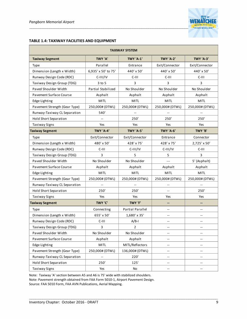
Taxiway System: The taxiway system totals nearly 16,000 linear feet, and consists of a full-length parallel,
exits, and connectors (‘A’, ‘B’, ‘C’, and ‘F’) to support the ingress and egress of aircraft between the runway
and terminal area facilities. The airfield taxiway configuration was previously developed to serve the
former three-runway system, with taxiways sections subsequently re-purposed or closed. In 2016, Taxiway
‘A’ segments were reconfigured as part of the parallel taxiway extension associated with the Runway 12-
30 extension. Table 1.4 summarizes details of the taxiway system, facilities, and equipment capabilities.

Pangborn Memorial Airport ____________________________________________________________________________________
____________________________________________________________________________________ Inventory Chapter: October 2016 - DRAFT 7
EXHIBIT 1.2: AIRPORT DIAGRAM
Note: Runway 7-25 is closed until further notice due to pavement deterioration. Source – Aerial: FAA Photo Source (August, 2016). Source – Airport Diagram: FAA Airport Facility Directory (Modified by Mead & Hunt).

Pangborn Memorial Airport ____________________________________________________________________________________
____________________________________________________________________________________ Inventory Chapter: October 2016 - DRAFT 8
TABLE 1.3: RUNWAY FACILITIES AND EQUIPMENT
Note: Runway 12-30 extended from 5,700’ to 7,000’ in 2016.
Note: Runway 7-25 is closed until further notice due to pavement deterioration.
Note: See Appendix for definitions and acronyms.
Source: FAA Form 5010-1; FAA Instrument Procedures; EAT ALP Drawings.
Runway End 7 Runway End 25 Runway End 12 Runway End 30
Runway Design Code (RDC)
Taxiway Design Group (TDG)
Critical Planning Aircraft
Design Aircraft
Runway Length x Width
Runway Type
Runway Shoulder Width
Runway Blast Pad None None 150' x 200' None
Runway Displaced Threshold None None None None
Stopway Distance None None None None
Land & Hold Short (LASHO)
In-Line Taxiway None None None None
Pavement Surface Course
Pavement Markings
Distance-to-Go Markers No No Yes Yes
Pavement Strength - Pounds
(Aircraft Gear Type)
Runway Edge Lights
Runway Visibil ity Range (RVR) No No None None
Runway Lighting Systems None None PAPI-4L, REIL PAPI(P2L), RAIL, REIL
Runway Instrument Approaches Visual VisualILS, RNAV (RNP),
VOR/DME
RNAV (RNP),
VOR/DME
1-Mile / 318’ 1-Mile / 391’
(A, B, C) (A, B, C)
Navaid Systems (On-Airport)
RUNWAY SYSTEM
A-I (Small Aircraft) C-III (Large Aircraft)
Facility Component
Group 1A Group 5 (FAA Standard)
Runway 12-30Runway 7-25
Single Engine Piston Regional Transport Turboprop
Beech Bonanza 36 Bombardier Q400
4,460’ x 75’ 7,000’ x 150’
None None
Crosswind Primary
±30' Asphalt Width Varies ±20' Asphalt Width Varies
RUNWAY NAVIGATIONAL AID SYSTEMS
ILS, RNAV (RNP), VOR/DME
Basic Precision
Asphalt (Not Grooved) Asphalt (Grooved)
77,000 (DWL)
136,000 (DTWL)
100,000 (DWL)
250,000 (DTWL)
None High Intensity (HIRL)
Approach Minimums (Lowest) N/A N/A
Pangborn Memorial Airport ____________________________________________________________________________________
____________________________________________________________________________________ Inventory Chapter: October 2016 - DRAFT 9
TABLE 1.4: TAXIWAY FACILITIES AND EQUIPMENT
Note: Taxiway 'A' section between A5 and A6 is 75' wide with stabilized shoulders.
Note: Pavement strength obtained from FAA Form 5010-1, Airport Pavement Design.
Source: FAA 5010 Form, FAA AVN Publications, Aerial Mapping.
Taxiway Segment TWY 'A' TWY 'A-1' TWY 'A-2' TWY 'A-3'
Type Paral lel Entrance Exit/Connector Exit/Connector
Dimension (Length x Width) 6,935’ x 50' to 75’ 440’ x 50’ 440’ x 50’ 440’ x 50’
Runway Design Code (RDC) C-III/IV C-III C-III C-III
Taxiway Design Group (TDG) 3 to 5 3 3 3
Paved Shoulder Width Partial Stabi lized No Shoulder No Shoulder No Shoulder
Pavement Surface Course Asphalt Asphalt Asphalt Asphalt
Edge Lighting MITL MITL MITL MITL
Pavement Strength (Gear Type) 250,000# (DTWL) 250,000# (DTWL) 250,000# (DTWL) 250,000# (DTWL)
Runway-Taxiway CL Separation 540’ -- -- --
Hold Short Separation -- 250’ 250’ 250’
Taxiway Signs Yes Yes Yes Yes
Taxiway Segment TWY 'A-4' TWY 'A-5' TWY 'A-6' TWY 'B'
Type Exit/Connector Exit/Connector Entrance Connector
Dimension (Length x Width) 480’ x 50’ 428' x 75' 428’ x 75’ 2,725’ x 50’
Runway Design Code (RDC) C-III C-III/IV C-III/IV C-III
Taxiway Design Group (TDG) 3 5 5 3
Paved Shoulder Width No Shoulder No Shoulder --- 5' (Asphalt)
Pavement Surface Course Asphalt Asphalt Asphalt Asphalt
Edge Lighting MITL MITL MITL MITL
Pavement Strength (Gear Type) 250,000# (DTWL) 250,000# (DTWL) 250,000# (DTWL) 250,000# (DTWL)
Runway-Taxiway CL Separation -- -- -- --
Hold Short Separation 250’ 250’ -- 250’
Taxiway Signs Yes Yes Yes Yes
Taxiway Segment TWY 'C' TWY 'F' -- --
Type Connecting Partial Parallel -- --
Dimension (Length x Width) 655’ x 50’ 1,680’ x 35’ -- --
Runway Design Code (RDC) C-III A/B-I -- --
Taxiway Design Group (TDG) 3 2 -- --
Paved Shoulder Width No Shoulder No Shoulder -- --
Pavement Surface Course Asphalt Asphalt -- --
Edge Lighting MITL MITL/Reflectors -- --
Pavement Strength (Gear Type) 250,000# (DTWL) 136,000# (DTWL) -- --
Runway-Taxiway CL Separation -- 220' -- --
Hold Short Separation 250’ 125' -- --
Taxiway Signs Yes No -- --
TAXIWAY SYSTEM
Pangborn Memorial Airport ____________________________________________________________________________________
____________________________________________________________________________________ Inventory Chapter: October 2016 - DRAFT 10
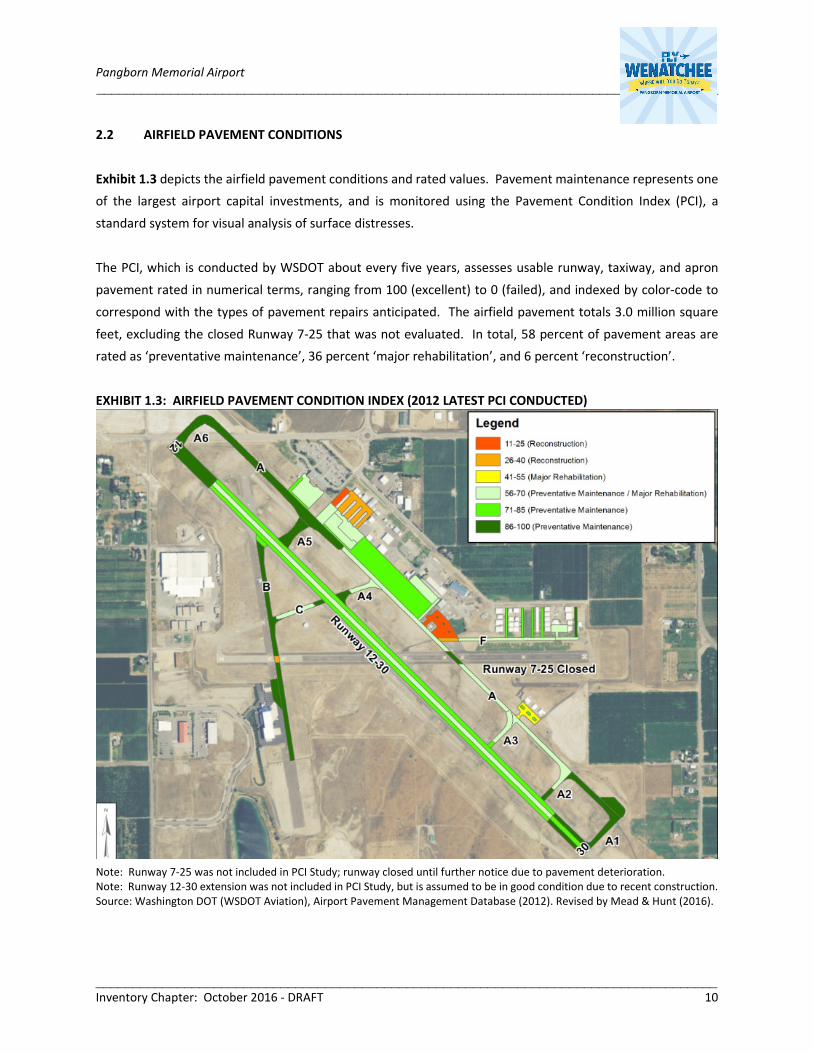
2.2 AIRFIELD PAVEMENT CONDITIONS
Exhibit 1.3 depicts the airfield pavement conditions and rated values. Pavement maintenance represents one
of the largest airport capital investments, and is monitored using the Pavement Condition Index (PCI), a
standard system for visual analysis of surface distresses.
The PCI, which is conducted by WSDOT about every five years, assesses usable runway, taxiway, and apron
pavement rated in numerical terms, ranging from 100 (excellent) to 0 (failed), and indexed by color-code to
correspond with the types of pavement repairs anticipated. The airfield pavement totals 3.0 million square
feet, excluding the closed Runway 7-25 that was not evaluated. In total, 58 percent of pavement areas are
rated as ‘preventative maintenance’, 36 percent ‘major rehabilitation’, and 6 percent ‘reconstruction’.
EXHIBIT 1.3: AIRFIELD PAVEMENT CONDITION INDEX (2012 LATEST PCI CONDUCTED)
Note: Runway 7-25 was not included in PCI Study; runway closed until further notice due to pavement deterioration.
Note: Runway 12-30 extension was not included in PCI Study, but is assumed to be in good condition due to recent construction.
Source: Washington DOT (WSDOT Aviation), Airport Pavement Management Database (2012). Revised by Mead & Hunt (2016).

Pangborn Memorial Airport ____________________________________________________________________________________
____________________________________________________________________________________ Inventory Chapter: October 2016 - DRAFT 11
2.3 AIRSPACE SYSTEM
Exhibit 1.4 depicts the various types of airspace classified by the FAA and Exhibit 1.5 shows the aeronautical
chart for the surrounding airspace structure, navigational routes, and public use airports. The Airport itself is
in Class G airspace, bordered by Class E airspace, which is controlled and uncontrolled airspace configured to
contain instrument flight procedures at non-towered facilities.
The Class E control zone airspace extends outward beyond the runway ends to accommodate instrument
approach and departure procedures, which also inter-connects with the Class E airspace associated with the
Quincy (80T), Ephrata (EPH), and Moses Lake (MWH) Airports. Air traffic control services within the Airport
vicinity are provided by the Seattle Air Route Traffic Control Center (ARTCC), with the Seattle Flight Service
Station (FSS) providing flight planning and advisory services.
EXHIBIT 1.4: AIRSPACE CLASSIFICATION DIAGRAM
Source: Federal Aviation Administration Website; Obtained August, 2016.
The surrounding airspace does not contain any designated restricted or special-use airspace, other than traffic
patterns reserved for nearby public and private airports. The EAT VOR Station provides multiple civilian airway
routes for visual and low-level instrument flight conditions, and also supports the Airport’s instrument
approach and missed approach procedures. A radio controlled flying strip is located 1.5 miles east of the
Airport.

Pangborn Memorial Airport ____________________________________________________________________________________
____________________________________________________________________________________ Inventory Chapter: October 2016 - DRAFT 12
EXHIBIT 1.5: AERONAUTICAL/AIRSPACE CHART
Source: Federal Aviation Administration Website; Obtained August, 2016.
Airport Air Traffic Pattern
The Airport publishes a standard left-hand traffic pattern for Runway 30 and a right-hand traffic pattern for
Runway 12, in which the non-standard patterns are established on Runways 12 to provide greater separation
from higher terrain to the northeast and to avert traffic pattern conflicts with glider and other utility aircraft
traffic. Gliders landing on Runway 12-30 must plan their landing and rollout and expedite clearing the runway.
No gliders are permitted to takeoff or land with an aircraft on final approach. Powered aircraft and glider right
of way procedures are as follows, 1) emergency operations, 2) airline (Alaska Airlines) operations, 3) powered
aircraft, and 4) glider operations.

Pangborn Memorial Airport ____________________________________________________________________________________
____________________________________________________________________________________ Inventory Chapter: October 2016 - DRAFT 13
2.4 INSTRUMENT PROCEDURES
Table 1.5 identifies the Airport’s instrument approach
procedures by type, allowable aircraft categories, and
lowest approach minimums. The Airport has six
instrument approach procedures, four to Runway 12
and two to Runway 30. Runway 12 provides precision
procedures with the lowest approach minimums. The
surrounding terrain impacts the instrument
procedures and obstacle departure, resulting in higher
than standard minimums. Alaska Airlines has established propriety instrument approach procedures
separate from those published by the FAA, in order to gain lower Airport minimums using RNAV technology.
TABLE 1.5: INSTRUMENT APPROACH PROCEDURES
Note: Does not include Alaska Airlines proprietary instrument approach procedures
Source: FAA Terminal Procedures Publication, May 2016.
Runway
EndProcedure
Procedure
Type
Aircraft
Categories
Minimum
Descent
Altitude
(Feet AGL)
Visibility
Minimums
(Statute Mile)
ILS X Precision A, B, C 1,544' 1
ILS Y Precision A, B, C 2,539' 4
Non-Precision A, B, C, D 1,995' 2¾
Non-Precision A, B, C, D 2,071' 3
Non-Precision A, B, C, D 2,368' 4
Non-Precision A 2,660' 1¼
Non-Precision B 2,660' 1½
Non-Precision C, D 2,660' 3
Non-Precision A, B, C 1,623' 1
Non-Precision A, B, C 1,674' 1¼
Non-Precision A, B, C 1,728' 1½
Non-Precision A 3,180' 1¼
Non-Precision B 3,180' 1½
Non-Precision C, D 3,180' 3
12RNAV (RNP)
VOR/DME-C
ILS: Ins trument Landing Sys tem RNAV (GPS): Area Navigation (Required Navigation Performance)
AGL: Above Ground Level
30
VOR/DME-A
RNAV (RNP)
VOR/DME: VHF Omni-Directiona l Range/Dis tance Measuring Equipment
Precision: Horizontal and vertical guidance.
Non-Precision: Horizontal guidance only.
Minimums: The lowest visibility/altitude at
which the procedure is still valid.
Obstacle Departure: A flight procedure to keep
aircraft clear of known obstacles on departure.

Pangborn Memorial Airport ____________________________________________________________________________________
____________________________________________________________________________________ Inventory Chapter: October 2016 - DRAFT 14
3. TERMINAL AND LANDSIDE FACILITIES AND SUPPORT SERVICES
The terminal and landside facilities occupy a total of 70 acres, predominately situated in the northeast quadrant
of the Airport. Nearly 85 percent of the available northeast terminal flightline area is currently occupied. A
summary of the terminal facility locations are shown in Exhibit 1.6. The following describes the major terminal
infrastructure components, users, space allocation, and utilization:
• Air Carrier Facilities
• Air Cargo Facilities
• General Aviation/Tenant Facilities (GA)
• Airport Operations and Support Facilities (ARPT)
• US Forest Service (USFS)
EXHIBIT 1.6: TERMINAL FACILITY LOCATIONS
Source: GIS Mapping (Photo Dated July, 2015).

Pangborn Memorial Airport ____________________________________________________________________________________
____________________________________________________________________________________ Inventory Chapter: October 2016 - DRAFT 15
3.1 AIR CARRIER FACILITIES
Air carrier facilities occupy 10 acres, consisting of the passenger terminal building, dedicated aircraft apron,
and vehicle parking and automobile circulation facilities. The air carrier facilities are physically separated from
other aviation related facilities, which provide a self-contained secured area. Exhibit 1.7 depicts the location,
size and proximity of the air carrier building, apron and automobile parking/circulation facilities.
EXHIBIT 1.7: AIR CARRIER FACILITY LOCATIONS (BUILDING, APRON, AUTO PARKING)
Source: GIS Mapping (Photo Dated July, 2015).
Passenger Terminal Building
The commercial passenger terminal building is a 19,000 square-foot single story structure constructed in 1992.
The building exterior consists of board-formed concrete, with floor-to-ceiling aluminum framed storefront
windows and sliding doors, and a gable type standing seam metal roof. The building interior, designed with a
mixture of wood concrete and steel structure, is arranged in a linear fashion along a common hallway, which
provides a center corridor for the sequential processing of departing and arriving passengers. The building

Pangborn Memorial Airport ____________________________________________________________________________________
____________________________________________________________________________________ Inventory Chapter: October 2016 - DRAFT 16
accommodates airline and passenger processing facilities, the Transportation Security Administration (TSA),
rental car tenants, a food vending area, and the Airport administrative and operations offices. The secured
area consist of a single passenger security screening checkpoint (SSCP), a secured passenger departure hold
room with 105 seats, airline gate counter positions, separate women and men restrooms, and airline and TSA
operating areas. There are three passenger gate door access points, with the middle door used for scheduled
service.
The building layout, with an at-grade walkout aircraft gate system, was designed for handling passengers prior
to security directives brought about by the TSA, prior to the advent of new FAA/TSA security directives. The
building is well designed, constructed, and maintained, with the structure integrity is in good condition. Some
materials wear is evident, but not extensive. The interior lighting is sufficient, helped to a great extent by the
size and location of storefront window walls and clerestories. The mechanical systems, which operate on
multiple systems, are adequate. Some exterior building equipment near the entrance is perched behind
minimal screening. Exhibit 1.8 illustrates the terminal building floorplan configuration. Table 1.6 lists the
terminal building function areas, space allocation and level of service.
Building Landside Entrance
Passenger Departure Lounge
Passenger Baggage Claim

Pangborn Memorial Airport ____________________________________________________________________________________
____________________________________________________________________________________ Inventory Chapter: October 2016 - DRAFT 17
EXHIBIT 1.8: AIR CARRIER TERMINAL BUILDING FLOORPLAN DIAGRAM
Source: Airport Records, DOH Associates Drawings, Modified July 2016.
TABLE 1.6: TERMINAL BUILDING FUNCTIONAL AREAS
Source: Airport Site Inspection / Pangborn Memorial Airport Website, Modified; July 2016.
Air Carrier Apron
The airline apron is 90,000 square feet (250’ x 350’) of which 63,000 square feet (180’ x 350’) is outside of the
taxiway safety area. The apron includes two marked parking positions for regional turboprop aircraft, but does
not provide wingtip separation for simultaneous gate utilization or for aircraft parked overnight. The apron
accommodates airline ground handling equipment used to service aircraft and passenger processing, in
addition to space to allow for fueling and de-icing activities.
Air Carrier Vehicle Circulation and Parking Lots
The terminal building is served by a loop roadway, Pangborn Road, which connects with Grant Road. The loop
road provides three public parking access points, and one access to the administrative lot. The one-way three-
lane curbfront provides 225 linear feet of building frontage for the temporary parking for passenger loading
and unloading.
Airline Operations/Passenger ProcessingPublic
Seating
Area
(SF)
% Area
(SF)
Airline Operating Areas 105 7,000 37%
TSA -- 2,150 11%
Non-Airline Operating SpacePublic
Seating
Area
(SF)
% Area
(SF)
Tenant 16 2,400 13%
Adminstrative -- 1,150 6%
General Circulation / Restrooms / Mechanical 78 6,300 33%
TOTAL 199 19,000 100%

Pangborn Memorial Airport ____________________________________________________________________________________
____________________________________________________________________________________ Inventory Chapter: October 2016 - DRAFT 18
The passenger terminal parking lot is 148,400 square feet with 379 parking positions. The lot includes areas for
short-term, long-term, rental car, and employee/tenant parking. The short and long-term lots are not manned
to collect parking revenue passengers pay a fee at a kiosk. Combined, the short and long-term passenger lots
total 110,400 square feet and 280 parking spaces, with the long-term lot providing 80 percent of the passenger
space allocation. The peak public parking revenue month is around March, and the peak rental car revenue
month is around August. Table 1.7 quantifies the automobile parking facilities by lot.
TABLE 1.7: AIRLINE AUTOMOBILE PARKING LOTS
Source: On-Site Airport Inspect and Airport Aerial Mapping; June, 2016.
Commercial Ground Transportation Services
Ground transportation services include on-demand taxis, private livery, and hotel shuttles. The Airport is not
served by Link Transit, which is a public transit bus service providing year-round scheduled routes and
paratransit service for communities in Chelan and Douglas Counties.
3.2 AIR CARGO TERMINAL FACILITIES
Air Cargo Facilities: The air cargo facilities occupy 3.5 acres, consisting of a sort building, aircraft apron, and
vehicle access and parking lot. The air cargo facilities are used by Empire Airlines primarily using turbine
aircraft. Alaska Airlines processes belly cargo through the air carrier terminal. The air cargo sort building is
20,000 square feet, which includes office space and sort and storage space accessed from the airside by bi-fold
doors. The air cargo apron is 50,000 square feet, with space to accommodate up to three parked aircraft, and
maneuvering space for integrated delivery trucks to process the loading and unloading of aircraft cargo. Exhibit
1.9 shows the air cargo location and facilities.
Lot and Parking FunctionMarked Parking
Spaces
Marked Parking
Spaces (%)
Area
(SF)
Area
(%)
Short-Term 45 12% 24,000 16%
Lot A - Handicap 5 -- 2,000 --
Lot B 40 -- 22,000 --
Long-Term 235 62% 86,400 58%
Lot A 49 -- 21,800 --
Lot B 41 -- 21,800 --
Lot C 100 -- 36,000 --
Lot D 45 -- 36,000 --
Rental Car 69 18% 25,500 17%
Employee/Tenant 30 8% 12,500 8%
Lot A 8 -- 3,000 --
Lot B 22 -- 9,500 --
Total 379 100% 148,400 100%

Pangborn Memorial Airport ____________________________________________________________________________________
____________________________________________________________________________________ Inventory Chapter: October 2016 - DRAFT 19
EXHIBIT 1.9: AIR CARGO FACILITIES
Source: GIS Mapping (Photo Dated July, 2015).
3.3 UNITED STATES FOREST SERVICE (AERIAL FIREFIGHTING TENANT)
The US Forest Service maintains on-airport facilities that support fixed-wing planes and helicopters used by
USFS to combat wildfires. The USFS facilities are located immediately south of the apron used by air cargo
carriers, and include an administrative building, and paved apron with dedicated helicopter landing pads. The
aircraft are used to provide reconnaissance, transport firefighters, deploy smokejumpers, deliver equipment
and supplies, and drop fire retardant, in addition to other fire dispatch function supported from the Central
Washington Interagency Communications Center. The larger USFS transports do not operate from the Airport.
As reported by the USFS website, the department is highly interested in new technologies and envisions the
potential to operate Unmanned Aircraft Systems (UAS) to support a host of natural resource management
activities in the future, including forest health protection, wildfire suppression, research, recreational impacts,
and law enforcement.

Pangborn Memorial Airport ____________________________________________________________________________________
____________________________________________________________________________________ Inventory Chapter: October 2016 - DRAFT 20
3.4 GENERAL AVIATION TERMINAL FACILITIES
The general aviation facilities, which provide aircraft and pilot services for transient and based users, occupy
50 acres on the east side of the airfield and five acres on the west side. These areas consist of hangars, support
buildings, paved aircraft parking areas, and automobile parking occupied by various tenant service providers.
The fixed base operator, Pangborn Flight Center, operates from an office-hangar building located along the
main general aviation apron, and is managed by the Airport.
The following general aviation services are offered:
- Aircraft Ground Handling/Servicing (FBO Provider)
- Aircraft Fueling - Truck Dispensing and Self-Service (FBO Provider)
- Pilot Amenities / Flight Planning Supplies
- Major and Minor Aircraft Maintenance, Repair, Refurbishment, Aircraft Parts
- Flight Training and Instruction
- Aircraft Rental
- Agricultural (Seasonally Based)
- Glider/Sailplane Soaring (Club)
- Manufacturing of ultralight & light sport aircraft/parachutes
- Reproduction of historic and classic aircraft
General Aviation Aircraft Parking Aprons
Combined, the two main public-use general aviation aprons total 297,500 square feet and provide 52 marked
tie-down/parking positions to accommodate fixed-wing and helicopter aircraft. Aircraft parking aprons are
described below in Table 1.8 and shown in Exhibit 1.10.
General Aviation Aircraft Hangars
Hangars are comprised of 39 building structures, which provide for 76 storage units and combined floor area
of over 425,000 square feet. Approximately 96 percent of the based aircraft are stored in hangars, and airport
records show that vacancy is generally between one to three units. The hangar composition and associated
building area entails T-hangars (32,500 SF = 8 percent), executive hangars (64,500 SF = 15 percent), and
common clear-span hangars (328,500 SF = 77 percent). The largest clear-span hangar is the Executive Flight
building (275,000 SF), located on the west side of the airfield. The T-hangars located south of the air carrier
terminal building are the older structures, with a trend towards the construction of executive-type hangars
principally located north of the former Runway 25 end.

Pangborn Memorial Airport ____________________________________________________________________________________
____________________________________________________________________________________ Inventory Chapter: October 2016 - DRAFT 21
EXHIBIT 1.10: GENERAL AVIATION FACILITY LOCATIONS
Source: GIS Mapping (Photo Dated July, 2015).
TABLE 1.8: GENERAL AVIATION AIRCRAFT APRONS
GENERAL AVIATION - PUBLIC USE
Apron Area
(Designation)Apron Fuction
Apron
Dimension
Area
(SF)Surface
Parking Spaces
(Marked Small/Large)
General Aviation
T-Hangar Area;
East Side
(GA-1)
Based and Transient Parking;
Aircraft Manuevering; Access to T-
Hangars
550' x 200' 110,000 Asphalt 28 Tie-Downs - Small
General Aviation
FBO Area;
East Side
(GA-2)
FBO Ramp, General Aviation Based,
Itinerant; Fl ight Training,
Agricultural Spray Operator.
Access to FBO and Executive
Hangars. Access to Self-Fueling.
750' x 250' 187,500 Asphalt20 Tie-Downs - Small
4+ Tie-Downs - Large
TOTAL -- -- 297,500 --48 Tie-Downs - Small
4+ Tie-Downs - Large

Pangborn Memorial Airport ____________________________________________________________________________________
____________________________________________________________________________________ Inventory Chapter: October 2016 - DRAFT 22
Source: On-Site Airport Inspect and Airport Aerial Mapping; June, 2016.
3.4 AIRPORT SUPPORT FACILITIES
Aircraft Fuel Storage/Dispensing
Table 1.9 summarizes the aircraft fuel storage facilities, dispensing, and volumes. Jet-A fueling is dispensed
from a fuel truck, and the 100LL Avgas from a pump station on the apron. Historically, Jet-A sales constitute
about 70 percent of the fuel volume, and 100LL Av Gas is 30 percent. The peak fuel sale months are July and
August.
TABLE 1.9: AIRCRAFT FUEL STORAGE
Note: Jet-A fuel used by turbine powered aircraft, 100LL Avgas used by piston-powered aircraft.
Source: Airport Records (Obtained July, 2016).
GENERAL AVIATION - OTHER/TENANT/PRIVATE USE
Apron Area
(Designation)Apron Fuction
Apron
Dimension
Area
(SF)Surface
Parking Spaces
(Marked)
General Aviation
Executive Hangar
Area; West Side
(GA-3)
Based and Transient Parking;
Aircraft Manuevering; Access to
Executive Hangar; Fueling
780' x 150' 117,000 Asphalt3 Tie-Downs - Small
3 Tie-Downs - Large
USFS/Firefighting
(USFS)Parking and Staging 350' x 150' 60,000 Asphalt
4 Helicopter Pads
Fixed Wing Not Marked
Soaring Club
(S)Parking and Staging 90' x 150' 13,500 Asphalt Not Marked
Agricultural Spray
(AG)Parking and Staging 90' x 150' 30,000 Asphalt Not Marked
TOTAL -- -- 103,500 --3 Tie-Downs - Small
3 Tie-Downs - Large
Storage Type Lessee / Owner Facilities
(1) 20,000 gal lon tank (Jet-A)
Abovegound; North of SRE Building
Dispensing: Fuel Truck
(2) 10,000 gal lon tank (100LL)
Underground; FBO GA Apron
Dispensing: Aircraft Self-Serve
Executive Fl ight
(Proprietary)
(2) 12,500 gal lon tank (Jet A)
Located North of Building/Hangar
Fuel Dispensing Trucks Airport Owned 2,500 gal lon Jet-A Truck
Jet-A
100LL 40,000 to 60,000 Gallons (Peak Month: July to September)
Storage and Dispensing
Fuel Storage Tanks
Airport Operated
(Bulk Storage)
Annual Fuel Volume Sales (Average Range)
100,000 to 120,000 Gallons (Peak Month: June to September)

Pangborn Memorial Airport ____________________________________________________________________________________
____________________________________________________________________________________ Inventory Chapter: October 2016 - DRAFT 23
Aircraft Rescue and Firefighting (ARFF)
As a commercial passenger service facility, on-site Airport Rescue and Firefighting (ARFF) services are provided.
The ARFF station, Station 222, is located along the main general aviation apron, north of the air cargo facility.
The Airport provides firefighting staffing through a mutual aid agreement with Douglas County Fire District #2.
ARFF staff are available during commercial flight operations, and assist in the surrounding areas of Douglas
County when not needed at the Airport.
Airport Maintenance/Equipment Storage (SRE)
The Airport has a 10,000 square-foot equipment storage building, a 4,200 square-foot garage, and a 3,000
square-foot shop building which are located north east of the general aviation terminal building.
3.5 SURFACE TRANSPORTATION
The Douglas County Six Year Transportation Improvement Program 2016-2021 identifies three roadway
projects planned within the Airport vicinity. The first is an intersection project is planned at Grant Road and
South Van Well Avenue in order to improve safety. The second is a project that will connect 10th Street SE to
South Ward Avenue along with realignment, widening, and reconstruction of current road. The third is
intersection improvements at South Van Well Avenue and 4th Street SE to improve safety.
3.6 AIRPORT UTILITIES
Table 1.10 summarizes the on-Airport utilities to generally describe the types, location, capacities, and
recognize service deficiencies and potential improvements. Separate utility systems serve the Airport and
Pangborn Airport Business Park.
4. METEOROLOGICAL CONDITIONS
Meteorological conditions impact aircraft performance and influences aviation activities, as largely influenced
by winds, temperature, cloud conditions, and precipitation types. Table 1.10 summarizes the climatic weather
characteristics for the Airport region.
4.1 Wind Patterns
Wind patterns are an important meteorological factor in assessing runway utilization and for determining
runway design requirements in accordance with FAA aircraft category standards. Exhibit 1.11 plots the
prevailing wind patterns from Airport wind observations for all-weather and instrument conditions.

Pangborn Memorial Airport ____________________________________________________________________________________
____________________________________________________________________________________ Inventory Chapter: October 2016 - DRAFT 24
TABLE 1.10: AIRPORT UTILITY SYSTEMS
Source: Airport Staff and RH2 Data (Obtained August, 2016).
Utility Service Provider System / Capacities / Remarks
Electric PowerDouglas County
Public Util ity District
Airport power is supplied primarily through underground cables. Two
substations supply the Airport including the South Nile Substation
located to the west and the Pangborn Substation located to the east. The
Veedol Substation is under construction to the northeast. Electric power
generally supplies heat to the newer Airport buildings, while fuel oi l is
used for the older buildings.
WaterEast Wenatchee
Water District
Airport water system consists of both private and public water mains,
ranging from 2" to 12" in diameter. The Nile pump station is located to
the west. The Veedol Water Reservoir is located to the northeast.
Sanitary SewerDouglas County Sewer
District
Two pump stations serve the Airport. The Batterman pump station
located northeast of the Airport extends the regional system south to the
air carrier terminal building (continuation of the regional line along the
east side terminal area has been proposed from the Douglas County
Sewer District facil ity east of Union Avenue). The Pangborn Pump Station
is within the Pangborn Airport Business Park and provides domestic
sewer service to the west side of the Airport property.
Gas Cascade Natural GasThe natural gas system provides service to the the western portion of the
Airport, including several lots within the Pangborn Airport Business Park.
Stormwater
SystemsPangborn Airport
The Airport's stormwater system was largely constructed in the 1940's,
with various stormwater expansions and modifications occurring since,
mostly connected with major Airport improvements. The stormwater
system for the runway includes a series of catch basins and pipes that
outlet to the southwest or into infiltration galleries. Drywells
accommodate stormwater in the terminal and general aviation areas.
The Pangborn Airport Business Park is served by a separate stormwater
system maintained by the Port of Douglas County, instal led in the late
1990’s, and extended in 2014 to accommodate runoff throughout the site.
Irrigation System
Operator: Greater
Wenatchee Irrigation
District (GWID)
Owner: US Bureau of
Reclamation
The Greater Wenatchee Irrigation District (GWID) has irrigation mains on
the west, south, and east sides of the Airport and a reservoir and pump
station near the southwest corner of the Airport. Irrigation water is
provided to the Airport and used to irrigation landscaping at the terminal
building and around the terminal facil ities.
Communications FrontierHigh speed fiber extends to the Airport air carrier terminal building and
is installed to the Pangborn Airport Business Park.

Pangborn Memorial Airport ____________________________________________________________________________________
____________________________________________________________________________________ Inventory Chapter: October 2016 - DRAFT 25
4.2 Runway Crosswind Conditions
Table 1.12 lists the all-weather and instrument runway crosswind coverage for 10.5, 13, 16, and 20 knot
crosswind component. Wind conditions affect aircraft to varying degrees. The ability to land and takeoff with
a crosswind varies according to aircraft characteristics and pilot capabilities. Generally, smaller aircraft are
more greatly affected by crosswinds. Runway 12-30 achieves in excess of 95 percent crosswind coverage at
10.5 knots, which means that it also provides over 95 percent coverage for the 13, 16, and 20 knot crosswinds.
Per FAA design standards, the existing single runway provides sufficient crosswind capabilities to accommodate
each aircraft type during all-weather, visual, and instrument wind crosswind conditions.
The prevailing winds and peak-gusts are predominately from the west, and to a lesser extent, from the east.
Annually, calm to light winds (0-11 knots) occurs 86 percent of the time, with gusty winds (greater than 16
knots) occurring 5 percent of the time. Winds greater than 11 knots but less than 16 knots occur at the airport
9 percent of the time. Runway 12 captures about 25 percent of traffic and Runway 30 about 75 percent with
respect to prevailing wind patterns. It should be noted that runway approach and departure utilization is
largely influenced by wind direction, but also instrument procedures, and pilot preference in consideration of
the desired parking destination.
EXHIBIT 1.11: WIND DIAGRAMS (ALL WEATHER AND INSTRUMENT)

Pangborn Memorial Airport ____________________________________________________________________________________
____________________________________________________________________________________ Inventory Chapter: October 2016 - DRAFT 26
TABLE 1.11: CLIMATIC/METEOROLOGICAL SUMMARY
Source: NOAA Climatic Meteorological Data Disk and NOAA Website Data, Obtained July 2016.
TABLE 1.12: CROSSWIND WIND COVERAGE
Source: FAA AGIS Wind Data Observations (Obtained July, 2016)
Climate Event Climate Description Value
Annual Mean 51.3° F
Annual Monthly Mean Maximum 74.2° F (August)
Annual Monthly Mean Minimum 27.9° F (December)
Mean Month Maximum (Month) 88.7° F (July)
Hottest Month (Extreme) 105° F (July)
Average Annual Days Above 65F 176 Days
Average Annual Days Above 90F 37 Days
Average Annual Days with Precipitation 67.9 Days
Average Annual Mean Rainfall Total 8.0 Inches
Mean Maximum Monthly Precipitation 1.4 Inches
Annual Days More Than .10" 25.1 Days
Snowfall Average Annual Mean Total 26 to 33 Inches
Snowfall Mean Maximum Month 12.9 Inches
Visual Flight Rule (VFR) Conditions 88%
Instrument Flight Rule (IFR) Conditions 10%
Low Instrument Flight Rule (IFR) Conditions 2%
Days with Fog 56
Days with Thunderstorms 6
Prevailing Wind Direction (From) Westerly
Average Prevailing Wind Direction (From) 7 Knots
Temperature
Precipitation
Sky Conditions
Winds
Runway10.5-Knot
Component
13-Knot
Component
16-Knot
Component
20-Knot
Component
Runway 12-30 98.92% 99.44% 99.79% 99.94%
Runway 7-25 (Closed) 96.52% 98.78% 99.72% 99.95%
Runway 12-30 & Runway 7-25 Combined 99.78% 99.89% 99.95% 99.98%
Runway 12-30 99.86% 99.92% 99.96% 99.98%
Runway 7-25 (Closed) 99.78% 99.88% 99.95% 99.99%
Runway 12-30 & Runway 7-25 Combined 99.93% 99.95% 99.97% 99.99%
NOTE: CROSSWIND COMPONENT COMPUTED USING RUNWAY TRUE BEARINGS (135.018, 90.023)
NOTE: ALL WEATHER CONDITIONS: PERIOD OF RECORD: 2006 TO 2015 WITH 102,364 OBSERVATIONS.
NOTE: IFR WEATHER CONDITIONS: PERIOD OF RECORD: 2006 TO 2015 WITH 17,324 OBSERVATIONS.
NOTE: VFR WEATHER CONDITIONS: PERIOD OF RECORD: 2006 TO 2015 WITH 85,409 OBSERVATIONS.
ALL-WEATHER WIND DATA OBSERVATIONS (PERCENT COVERAGE)
INSTRUMENT WIND DATA OBSERVATIONS (PERCENT COVERAGE)

Pangborn Memorial Airport ____________________________________________________________________________________
____________________________________________________________________________________ Inventory Chapter: October 2016 - DRAFT 27
5. AIRPORT LAND USES AND REGULATIONS
Airport land use compatibility is regulated through zoning ordinances to govern property development
consistent with aviation operations and facilities, ensure the protection of runway safety and clear zones for
the protection of public safety; and to attract compatible businesses.
5.1 Governmental Jurisdiction
The Airport, situated two miles east of the East Wenatchee city limits and one-mile east of the East Wenatchee
Urban Growth Area (UGA) boundary, is located within an unincorporated area zoned by the Douglas County
Board of County Commissioners. A northwest portion of the Airport traffic pattern overlays the UGA. Per the
Douglas County Countywide Comprehensive Plan, the Airport is designated an Essential Public Facility under
the Growth Management Act (GMA) with prescribed land use goals and policies. It is intended that minimum
requirement criteria be included in the development regulations of the comprehensive plan, intended to
preserve the Airport such that it can change with the community to meet the needs of the County, its residents,
and businesses. The Airport is within the Pangborn Industrial Service Area, a 1,449-acre island UGA planning
area boundary, which does not include residential or commercial activities due incompatibility.
The Pangborn Industrial Service Area is located within the Greater East Wenatchee Sub-Area Plan. Activities
located in this area are designed to be compatible with both airport activities and surrounding agricultural
resource land.
5.2 On-Airport Land Uses
The Airport property totals 700 acres, comprised of four land use categories as designated by past Airport
planning studies, including: Airfield Operation/Approach Protection (AO); Air Carrier Terminal Area (TA);
General Aviation/Cargo/Aircraft Storage (GA); and Non-Aviation Use (NAU). The aeronautical land uses, which
include AO, TA and GA, are committed to existing and future aviation developable areas, and combined,
occupies nearly 530 acres (75 percent) of the total Airport property. The NAU, which totals 170 acres (25
percent), is comprised of a mix of existing leased business sites including the Airport Business Park, areas for
temporary ground lease storage and activities, and farmed areas. The former on-Airport farming area,
predominately located along the south airfield quadrant, had occupied 40 acres and is fallow.
Exhibit 1.12 depicts the Pangborn Airport Business Park and lot layouts, located within the southwest quadrant
of the Airport, with roadway access via South Union Avenue. The business park, which is managed by the Port
of Douglas County, occupies 70 acres and is comprised of 20 lots which vary from about 1.5 to 4.1 acres. Three
lots extending along Taxiway B, including the Executive Flight hangar, have access potential to the airfield.

Pangborn Memorial Airport ____________________________________________________________________________________
____________________________________________________________________________________ Inventory Chapter: October 2016 - DRAFT 28
EXHIBIT 1.12: AIRPORT BUSINESS PARK LOTS
Source: Pangborn Memorial Airport Business Park, Douglas County Mapping, Obtained October 2016.
5.3 Surrounding and Zoned Land Uses
The Airport is surrounded mostly by large-parcel agricultural land uses, with residential subdivision to the
northwest, sparse large-lot residential to the south, and commerce centers to the north and northeast. The
following list the Airport and surrounding Douglas County zoning districts, as depicted by Exhibit 1.13.
Douglas County On-Airport Zoning Districts:
- General Industrial (I-G)
- Commercial Agricultural 10 (AC-10)
Douglas County Zoning Districts Surrounding Airport:
- North - General Industrial (I-G)
- East, South, West - Commercial Agricultural 10 (AC-10)
- Southwest - Rural Resource 5 (RR-5)
- Northwest - Rural Resource 2 (RR-2)

Pangborn Memorial Airport ____________________________________________________________________________________
____________________________________________________________________________________ Inventory Chapter: October 2016 - DRAFT 29
EXHIBIT 1.13: AIRPORT AND SURROUNDING ZONING DISTRICTS
Note: Exhibit does not reflect existing Runway 12-30 extension to 7,000’ or Runway 7-25 closure.
Source: Douglas County Zoning Ordinance Map (March, 2015).
5.4 Airport Land Use Ordinances
Airports face unique land use compatibility and encroachment challenges, in which incompatible development
can impact the operating capability of the Airport as well as endanger the lives of people in the air and on the
ground. The Airport’s area of land use and airspace influence extends and overlays multiple governmental
jurisdictions; including the Port of Douglas County, Port of Chelan County, Douglas County, Chelan County, City
of East Wenatchee and surrounding local communities. In addition, the Douglas County Comprehensive Plan
consists of several volumes that are incorporated by reference; Bridgeport Urban Area Comprehensive Plan,
Greater East Wenatchee Area Comprehensive Plan, Mansfield Urban Area Comprehensive Plan, Rock Island
Comprehensive Plan, Waterville Urban Area Comprehensive Plan, Douglas County Transportation Element,
Douglas County Capital Facilities Plan. To ensure that the Airport function is maintained, land use planning
tools and ordinances have been adopted to ensure that Airport land use conflicts are minimized to the greatest
extent possible, including the height of objects, safety area zones, and noise.
The Douglas County Board of Commissioners has adopted an Airport Overlay District AP-O zoning district that
is codified in Chapter 18.65 of the Douglas County Code. This district establishes Airspace Zones based on FAA
Part 77 imaginary surfaces and Airport Compatibility Zones (Zones 1, 2, 3, 5) based on NTSB safety data
prescribed by WSDOT Aviation Land Use Compatibility.
EAT AIRPORT

Pangborn Memorial Airport ____________________________________________________________________________________
____________________________________________________________________________________ Inventory Chapter: October 2016 - DRAFT 30
The AP-O district protects the viability of the Airport as a significant resource to the community by encouraging
compatible land uses, densities, and reducing hazards that may endanger the lives and property of the public
and aviation users. The ordinance prescribes development standards and site planning requirements per
boundary of the AP-O district. The AP-O Airport Compatibility Zones do not extend into other surrounding
governmental jurisdictions, however the Airspace Zones do extend beyond the Urban Growth Area (UGA), and
extend as an overlay into multiple governmental jurisdictions within Douglas County and Chelan County.
5.5 Airport Operating Regulations and Ordinances
Regulatory ordinances have been adopted, including “Minimum Standards for Commercial Activities” used to
regulate the conduct of commercial airport users and specify uniform thresholds for an operator engaged in
commercial aeronautical activities at the Airport, and “Airport Rules and Regulation” used to regulate the
conduct of airport users.
6. AIRPORT ECONOMIC PROFILE
Table 1.13 quantifies the Airport’s economic impact, measured in jobs, spending, and sales. The Airport
contributes to 284 full-time equivalent jobs resulting in $12 million in wages ($44,000 per job), and has business
sale impact totaling $41.0 million. Annual local and state tax revenue generated from the Airport totals $1.03
million.
TABLE 1.13: AIRPORT ECONOMIC IMPACT (ADJUSTED FOR 2016 DOLLARS)
Source: WSDOT Aviation Division website.
Economic Impact
Jobs from
Airport
Business
Jobs from
Visitor
Spending
Wages from
Airport Businesses
Wages from
Visitor Spending
Airport
Business Sales
Visitor Spending
Business Sales
Direct Impact 90 81 $4,300,000 $2,700,000 $17,100,000 $8,800,000
Indirect Impact 65 48 $2,500,000 $2,500,000 $7,400,000 $7,700,000
$6,800,000 $5,200,000
($44,000 Per Job) ($41,000 Per Job)
Note: 2010 study values adjus ted to 2015 dol lars .
Di rect Impact: amount of ini tia l purchase that remains within the loca l economy.
Indirect Impact: result from a purchases made to another industry and expenditures of employee wages ..
$41,000,000 ($43,000 Per Job)
Individual Total 155 129 $24,500,000 $16,500,000
Combined Total 284$12,000,000
Pangborn Memorial Airport ____________________________________________________________________________________
____________________________________________________________________________________ Inventory Chapter: October 2016 - DRAFT 31
6.1 Airport Regional Transportation and Economic Role
The Airport serves a broad economic value as a commerce center and critical component of the region’s
transportation system. As an Essential Public Facility, the Airport fosters one of the primary goals of the Greater
East Wenatchee Area in the desire to shift from a commuter economy to a jobs-based economy.
Wenatchee is known as the “Apple Capital of the World”. Agriculture is the leading industry in Chelan and
Douglas counties, with over 21 percent of the combined employment. Agriculture employment directly links
to nonfarm employment in the area through food processing, food packaging, and transportation. In addition
to agriculture, tourism plays a vital role to the area’s economy. Every year from the last week of April to the
first week of May, Wenatchee hosts the Washington State Apple Blossom Festival which brings a large amount
of tourists to the area. During the summers many tourists travel to Wenatchee to visit the area’s orchards,
wineries, and the Pybus Public Market. These visitors have a great effect on the hotel bookings, airline tickets,
spending, and sales tax for the area.
7. FINANCIAL OVERVIEW
This section presents a snapshot of the Airport’s financial structure, historical budgeting patterns, and other
influencing factors regarding the Airport’s revenue position.
7.1 Airport Financial Structure
The Airport Governing Board is the authorizing body responsible for the financial obligations to own, manage,
and improve Airport facilities. The Airport Governing Board approves of the annual budgets for maintenance
and operation, and for capital expenditures. As a public operated facility, fiscal duties must be conducted in
accordance with the federal grant assurance agreements and compliances, and other local and state business
requirements.
7.2 Airport Financial Overview (Fiscal Years 2011 to 2015)
Airport income statements for fiscal years 2011 to 2015 were reviewed to identify trends, income patterns and
major operating revenue and expense factors. During this fiscal period, operating revenues averaged $1.46
million annually, while operating expenses (excluding depreciation) averaged $2.10 million, with net profit/loss
operating deficit averaging $545,000 per year. Nearly 50 percent of the Airport’s operating revenue is
generated from building/hangar rents, of which 80 percent is derived from ‘aviation’ tenants and 20 percent
from ‘non-aviation’ tenants. Nearly 40 percent of the Airport’s operating expenses are dedicated to salaries,
benefits, taxes, and 30 percent attributed to fuel operations, which generates a positive Airport revenue. In
the last five years the Airport has shown an operating deficit, in which the Port contributions have averaged
$745,000, of which 60 percent was committed towards ‘operating’ expenses and 40 percent towards ‘capital’
expenses. The Airport’s general fund carry-over per year is $20,000.
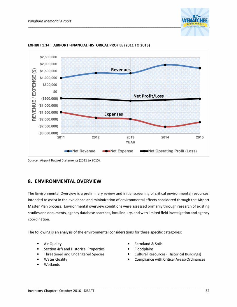
Pangborn Memorial Airport ____________________________________________________________________________________
____________________________________________________________________________________ Inventory Chapter: October 2016 - DRAFT 32
EXHIBIT 1.14: AIRPORT FINANCIAL HISTORICAL PROFILE (2011 TO 2015)
Source: Airport Budget Statements (2011 to 2015).
8. ENVIRONMENTAL OVERVIEW
The Environmental Overview is a preliminary review and initial screening of critical environmental resources,
intended to assist in the avoidance and minimization of environmental effects considered through the Airport
Master Plan process. Environmental overview conditions were assessed primarily through research of existing
studies and documents, agency database searches, local inquiry, and with limited field investigation and agency
coordination.
The following is an analysis of the environmental considerations for these specific categories:
• Air Quality • Farmland & Soils
• Section 4(f) and Historical Properties • Floodplains
• Threatened and Endangered Species • Cultural Resources ( Historical Buildings)
• Water Quality • Compliance with Critical Areas/Ordinances
• Wetlands
($3,000,000)
($2,500,000)
($2,000,000)
($1,500,000)
($1,000,000)
($500,000)
$0
$500,000
$1,000,000
$1,500,000
$2,000,000
$2,500,000
2011 2012 2013 2014 2015
RE
VE
NU
E /
EX
PE
NS
E (
$)
YEAR
Net Revenue Net Expense Net Operating Profit (Loss)
Net Profit/Loss
Revenues
Expenses

Pangborn Memorial Airport ____________________________________________________________________________________
____________________________________________________________________________________ Inventory Chapter: October 2016 - DRAFT 33
8.1 AIR QUALITY
According to the Environmental Protection Agency (EPA) Green Book of Nonattainment Areas for Criteria
Pollutants, the Airport is considered by the Office of Air Quality Planning and Standards to be in ‘attainment’
for all criteria pollutants (i.e. ozone, particulate matter, sulfur dioxide, lead, carbon monoxide, and nitrogen
dioxide), which is in compliance with National Ambient Air Quality Standards (NAAQS).
8.2 SECTION 4(F) AND HISTORICAL PROPERTIES
Section 4(F) refers to the section name of the U.S. Department of Transportation act of 1966 which provided
consideration of parks and recreation lands, wildlife and waterfowl refugees, and historic sites during
transportation developments. Before a project can be approved using Section 4(F) property it must be
determined that there is no feasible and prudent alternative that avoids the Section 4(F) property. The Airport
does not contain any known Section 4(F) properties. The nearest section 4(F) property is Kenroy Park, located
four miles west of the Airport. The nearest National Register of Historic Places site is the Rock Island Railroad
Bridge located 2.6 miles southwest of the airfield.
8.3 THREATENED AND ENDANGERED SPECIES
The United States fish and Wildlife Service (USFWS) Environmental Conservation Online System (ECOS) was
used to determine potentially occurring species listed in the Endangered Species Act (ESA) within the Airport
property area. According to the USFWS ECOS, the listed ESA species which have the potential to occur within
the Airport include the: Yellow-billed Cuckoo (Coccyzus americanus), Bull Trout (Salvelinus confluentus), Gray
wolf (Canis lupus), and Washington ground squirrel (Urocitellus washingtoni). The Washington Department of
Fish and Wildlife (WDFW) Priority Habitats and Species (PHS) database was also reviewed. The WDFW PHS
does not list any priority habitats or species records for the Airport Area. In addition, the FAA Wildlife Strike
Database was reviewed to determined known occurrences of wildlife species near the Airport. The species
listed on the FAA Wildlife Strike Database are common species, namely American kestrel, Horned lark, Eurasian
collared dove, Dark-eyed junco, American pipit, Gray partridge, Chukar, Sparrows, American robin, Finches,
European starling, Swallows, Barn swallow, Rock pigeon, White-throated swift, Tree swallow, Bank swallow
and other unknowns birds of various sizes. Due to the existing disturbed areas resulting from Airport
infrastructure and operations, lack of standing bodies of water, and ongoing agriculture activities, it is unlikely
that any of the above mentioned ESA listed species would be impacted by actions within the Airport area.
8.4 WATER QUALITY
The Airport is located within the Greater East Wenatchee Stormwater Utility boundary, as managed by Douglas
County. Mapping of the existing Airport stormwater system, including topography, impervious surfaces, and
drainage bases was conducted in 2016 as part of an Airport Stormwater Management Plan. This plan includes
mapping of the existing stormwater system and an operations and maintenance plan. Per Douglas County

Pangborn Memorial Airport ____________________________________________________________________________________
____________________________________________________________________________________ Inventory Chapter: October 2016 - DRAFT 34
Code Chapter 20.34, all Airport runoff shall be retained and disposed on-site or in a system designed for such
runoff and which does not flood or damage other properties. Stormwater systems are designed using the one-
hundred year twenty-four hour Type II SCS synthetic rainfall event.
Public entities that operate a Municipal Separate Storm Sewer System (MS4) that discharge stormwater must
get a permit to do so under U.S. Environmental Protection Agency rules. In Washington State, Department of
Ecology issues this permit which is a Phase II Municipal Stormwater Permit. The Airport would be a secondary
permittee. Regardless of whether a Municipal Permit is sought, construction of any new facilities will need to
be reviewed for current permitting requirements.
8.5 WETLANDS
The US Fish and Wildlife Service online National Wetlands Inventory (NWI) mapping system identifies one
wetland area within Airport property, a manmade detention pond within the Columbia Marketing
International, Inc. (CMI) leased premises, which does not appear to be a regulated wetland. Any impacts to
wetlands are to be coordinated with the United States Army Corps of Engineers.
8.6 FARMLAND AND SOILS
The NRCS online web soil survey system was used to identify Airport soil types. Mapping and table details
regarding the mapped soils within the Airport area are contained within the USDA/NRCS Soil Report. Airport
soils are comprised of the following:
• Pogue fine sandy loam (3% to 8% slopes): “Prime farmland if irrigated”
• Torriorthents (very steep): “Not prime farmland”
• Peshastin fine sandy loam, compacted substratum (3% to 8% slopes): “Prime farmland if irrigated”
• Pogue loam (8% to 15% slopes): “Farmland of unique importance”
According to the NRCS, the Pogue fine sandy loam with 3 to 8 percent slope is the dominant soil type accounting
for approximately 90 percent of Airport area. This soil type is associated with prime farmland if it is irrigated.
Potential impacts to this soil type, as well as similarly classified soils within the study area, would require
coordination with the NRCS to determine applicability or exemption to the Farmland Protection Policy Act
(FPPA).
8.7 FLOODPLAINS
The Airport is built on top of a 600-foot-high flood deposit terrace, with an elevation ranging from 1,100 to
1,300 feet above sea level. The Washington Department of Ecology identifies the Airport within the Moses
Coulee Watershed Water Resource Inventory Area (WRIA). The Federal Emergency Management Agency
(FEMA) Flood Insurance Rate Maps (FIRMs) identify the Airport and surrounding vicinity within the “Zone B”

Pangborn Memorial Airport ____________________________________________________________________________________
____________________________________________________________________________________ Inventory Chapter: October 2016 - DRAFT 35
floodplain, a region defined by areas between limits of the 100 and 500-year flood; or areas of 100-year shallow
flooding with depth less than 1-foot.
8.8 CULTURAL RESOURCES (HISTORICAL BUILDINGS)
A review of the Washington Department of Archaeology and Historic Preservation’s Washington Information
System for Architectural and Archaeological Records Data (WISAARD) did not reveal any properties listed on
the National Register of Historic Places (National Register) located on Airport property. This is also supported
by field surveys conducted on the Pangborn Airport Business Park in March 1997 and February 2012. This
review did not include research or evaluations to determine whether inventoried buildings qualify as eligible
for listing in the National Register. As part of future Airport developments, it is recommended that the
Washington State Department of Archaeology and Historic Preservation, State Historical Preservation Officer
(SHPO) be contacted prior to disturbances involving buildings older than 45 years.
8.9 COMPLIANCE WITH CRITICAL AREAS/ORDINANCES
Under the GMA, critical areas contained within the study area must adhere to applicable City or County
ordinances. Douglas County has developed codes, contained in Section 8.08, regarding the use and safety of
the Airport. The codes outline permits pertaining to property, fire prevention, aircraft operation, and motor
vehicle operations. The following are land use planning, zoning, and development regulations applicable or
referenced by way of governing Airport operating and land use:
Airport Mechanisms:
• Pangborn Memorial Airport, Ports of Chelan and Douglas Counties, Airport Master Plan.
• Douglas County Code, Chapter 18.65, Airport Overlay District AP-O Zoning District, May 2010.
• Douglas County Code, Section 8.08, Pangborn Field Airport: Code current through Ord. 15-14-50B,
passed December 1, 2015 and Resolution 14-01-50B passed October 28, 2014.
Local Jurisdiction Mechanisms:
• Douglas County Countywide Comprehensive Plan, 2015
• Douglas County Zoning for the Greater East Wenatchee & Rock Island Areas
• Douglas County Code of the West, 2011
• Greater East Wenatchee Comprehensive Plan - City of East Wenatchee, 2015
• Port of Douglas Strategic Plan Summary, 2011
• Port of Douglas Economic Leadership Roundtable, 2015
• Chelan County Comprehensive Plan, 2015
• Port of Chelan Comprehensive Plan, 2013

Pangborn Memorial Airport ____________________________________________________________________________________
____________________________________________________________________________________ Inventory Chapter: October 2016 - DRAFT 36
8.10 ENVIRONMENTAL CONCLUSION
This overview identifies potential considerations that may require more detailed environmental
documentation for project approval and permitting. Early identification of these environmental factors may
help avoid impeding future development plans. The overview is not intended to fulfill the environmental
clearance requirements outlined in FAA Order 1050.1F, Environmental Impacts and Procedures, nor satisfy the
requirements pursuant to the National Environmental Policy Act (NEPA) and Washington’s State Environmental
Policy Act (SEPA) statutory requirements. This overview does not constitute a formal biological/habitat
assessment, wildlife hazard site visit, or wetland delineation.
9 INVENTORY CHAPTER SUMMARY
The following summarizes the key inventory components noted per facility condition or functional deficiencies.
These bullet point items serve as the basis for subsequent master plan analysis:
Airfield:
• Future disposition of closed crosswind Runway 7-25.
• Continuous perimeter service roadway network.
• Continuous standard perimeter fencing (southeast quadrant).
• Airport ownership of Runway Protection Zones (RPZ) beyond the Runway 30 end.
• Non-standard Runway 12-30 shoulder width.
• Non-standard taxiway shoulder width on multiple taxiways.
• Public roadway through the Runway Protection Zones (RPZ) beyond the Runway 30 end.
• Runway 12-30 lateral ground terrain profile.
• Runway 30 RSA grading standards.
Terminal Area:
• Undersized air carrier apron aircraft parking area.
• Future disposition of aging buildings and hangars.
• Passenger terminal building needs to meet passenger demands and TSA security requirements.
• Passenger automobile parking lot capacity during peak operating periods.
• ARFF building (bay) dimension for accommodating current-generation ARFF vehicles.
• Hangar size and height to accommodate large turbine aircraft.
• Limited Snow Removal Equipment (SRE) building vehicle maneuvering area.
• Location of communication shelter and utility corridors within east side terminal area.
Landside:
Future disposition of on-Airport non-aeronautical leased areas.