pam beach island beach management agreement.pdf
TRANSCRIPT

Palm Beach Island Beach Management Agreement
Florida Department of Environmental Protection

Table of Contents Part I – BMA Main Agreement A) Threshold and Procedural Matters ........................................................................................... 2 B) Agreement Overview ............................................................................................................... 3 C) Description of Agreement Area ............................................................................................... 4 D) BMA Projects and Authorized Activities ................................................................................ 8 E) BMA Participant & Regulatory Agency Commitments ........................................................ 23 F) Net Ecosystem Benefits ......................................................................................................... 26 G) Avoidance, Minimization and Mitigation ............................................................................. 31 H) Individual Project Approval Process for In-Water Activities ............................................... 31 I) Individual Project Approval Process for Dune Construction ................................................ 34 J) Preservation of Third Party Rights ........................................................................................ 35 K) Term of Agreement ............................................................................................................... 35 L) Effective Date ........................................................................................................................ 36 M) Notices ................................................................................................................................... 36 N) Amendments and Updates ...................................................................................................... 37 O) Emergency Situations ............................................................................................................. 40 P) Termination/Exit ..................................................................................................................... 40 Q) Venue and Severability ........................................................................................................... 42 R) Signatures ................................................................................................................................ 43
Part II – Appendices A) Project Drawings
1. Sand Transfer Plant 2. Mid-Town Nourishment 3. Phipps Ocean Park Nourishment 4. Dune Conditions
B) Cell-Wide Monitoring and Mitigation Plans 1. Hardbottom Monitoring, Mitigation and Reporting 2. Cell-Wide Sea Turtle Habitat Monitoring Plan (FWC) 3. Physical Monitoring and Reporting Plan 4. Hardbottom Data and Analysis 5. Annual Monitoring Surveys and Due Dates for BMA Participants
C) General Conditions 1. Dune Restoration 2. Nourishments, Sand Transfer, Groins, In Water Work
D) Project Specific Monitoring and Protection Conditions E) Permit History Table F) Individual Project Agreement Checklists
1. Dunes 2. In-Water 3. BMA Fee
G) Outfall Data
1

A) Threshold and Procedural Matters
1. The Town of Palm Beach, Palm Beach County (Participants or BMA Participants) and
the State of Florida Department of Environmental Protection (DEP or Department) and the
Florida Fish and Wildlife Conservation Commission (FWC) have agreed to enter into this
Palm Beach Island Beach Management Agreement (Agreement or BMA) to coordinate beach
management activities within the Agreement Area defined in Article C.
2. This Agreement, including attachments and Appendices (collectively Agreement or
BMA), is entered into pursuant to the authority in sections 161.101, 403.061, and 403.0752,
Florida Statutes (F.S.). This Agreement is binding on all BMA Participants. Department
approvals issued pursuant to the Agreement will be subject to public notice, administrative
hearing and decision-making procedures, and include points of entry for third parties at the
time of Agreement and at Individual Project Approval (IPA), as set forth in the applicable
provisions of state law and this Agreement.
3. The BMA process established herein coordinates the regulatory responsibilities of the
Department with other state and federal agencies, and with the interests of the BMA
Participants and the public in a streamlined program to protect the environment and to
provide net ecosystem benefits pursuant to subsection 403.0752(2)(a), F.S.
4. This Agreement is intended to coordinate and facilitate flexible permitting for beach
management and to achieve net ecosystem benefits and related public objectives for the area.
The BMA Participants and the Department acknowledge that the Agreement and the
procedures and conditions for IPA set forth herein meet the substantive regulatory and
proprietary criteria of Chapter 161, Chapter 253, Part IV Chapter 373, and Chapter 403, F.S.,
and the BMA Participants have provided reasonable assurance that the objectives and
requirements of subsections 403.0752(1), (2), (3), and (4), F.S., are met.
5. The Agreement’s approach to authorizing projects and activities is centered on regional
management of the coastal system rather than the conventional project-by-project permitting
process. For this reason, the BMA will improve comprehensive coastal management and
result in a net ecosystem benefits to the coastal system through cell-wide monitoring of
resources, improved inlet bypassing, and efficient use of beach quality sand. In addition, the
Agreement is expected to generate a more cost-effective and efficient permitting process that
will reduce the BMA Participants’ costs, time delays, and permitting uncertainty.
2

6. Subsection 403.0752(2), F.S., provides that the Department and regulated entities may
enter into management agreements when the Department determines that:
a. Implementation of such an Agreement meets all the applicable standards and criteria,
so that there is a net ecosystem benefit to the subject ecosystem more favorable than
operation under applicable rules;
b. Entry into such an Agreement will not interfere with the Department’s obligations
under any federally delegated or approved program;
c. Implementation of the Agreement will result in a reduction in overall risks to human
health and the environment as compared to activities conducted in the absence of the
Agreement; and
d. The regulated entity has certified to the Department that it has in place internal
environmental management systems or alternative internal controls sufficient to
implement this Agreement.
The Department has determined that the requirements of subsection 403.0752(2), F.S., will
be satisfied through implementation of this Agreement.
B) Agreement Overview
The primary goal of the BMA is to define mutually agreeable methods among the
Department, local municipalities, and stakeholders for coastal erosion control, natural
community protection, and monitoring protocols in pursuit of regional management of Palm
Beach Island's coastal system, while providing net ecosystem benefits to the cell. Currently,
beach erosion control and inlet management activities are regulated, project by project, through
the Department’s Joint Coastal Permitting (JCP) Program. Beach erosion control activities, such
as beach restoration and nourishment projects, require three forms of authorization: coastal
construction permits (Chapter 161, F.S.), environmental resource permits (Part IV Chapter 373,
F.S.), and proprietary authorization to use sovereign submerged lands (Chapters 253 and 258,
F.S.). The JCP consolidates these authorizations into one permit and also serves as the final
determination of consistency with Florida’s Coastal Zone Management Program (CZM) and
water quality certification under the Clean Water Act.
The BMA Participants and Department initiated the Agreement to improve techniques for
managing the sand resources and beach erosion within the Palm Beach Island coastal cell
3

(Agreement Area) defined in Article C. (See map in Article C for a general depiction of the
area.) A primary goal of the Agreement is to develop a coordinated, long-term process that
facilitates predictable approval of qualifying coastal erosion control and inlet management
activities described herein. Ultimately, the Agreement is intended to facilitate regional
management of the Palm Beach Island coastal cell through mutually agreeable methods for
coastal erosion control, coastal ecosystem protection, and monitoring protocols.
This Agreement addresses State regulatory and proprietary approvals for managing the sand
resources and beach erosion within the Agreement Area. It sets forth the procedures and criteria
to be followed by the Department, the Florida Fish and Wildlife Conservation Commission
(FWC), and the BMA Participants for pre-application meetings and application submittal, review
and approval for individual projects within the Agreement Area, as well as coordination with
federal agencies and notice to the public. The Agreement also sets forth annual cell-wide
requirements for the BMA Participants to monitor the movement of sand, sea turtle nesting,
shorebird nesting, and exposure and burial of hardbottom and to perform aerial surveys.
Department staff reviewed the projects specifically described in Article D of the Agreement
to determine consistency with the substantive requirements of Chapter 161, Chapter 253, Part IV
Chapter 373, and Chapter 403, F.S., and their implementing rules, and for dune restoration,
Chapter 161, F.S., and its implementing rules. This review determined that cell-wide
management of sand resources and beach erosion would result in net ecosystem benefits.
Prior to construction, individual projects must demonstrate compliance with the conditions of
this Agreement under the IPA process set forth in Articles H & I. When conducted pursuant to
the conditions of this Agreement, those projects and activities will meet or exceed the applicable
substantive criteria of Chapter 161, Chapter 253, Part IV Chapter 373, and Chapter 403, F.S., and
their implementing rules. This Agreement also constitutes certification of compliance with state
water quality standards under Section 401 of the Clean Water Act, 33 U.S.C., and a finding of
consistency with Florida’s Coastal Zone Management Program, as required by Section 307 of the
Coastal Zone Management Act (CZMA).
C) Description of Agreement Area
1. The Agreement Area is generally defined by the boundaries of the coastal cell located
within the coastal system of Palm Beach Island, encompassing 15.7 miles of Atlantic Ocean
4

shoreline, and covering 34.5% of the Palm Beach County Shoreline. The approximate
shoreline length and critically eroded shoreline length for each municipality within the
Agreement Area are summarized in Table 1. Critical erosion shoreline lengths are also
depicted in Figure 1 below.
Table 1: Shoreline Lengths and Critically Eroded Areas for Municipalities within the BMA
Palm Beach Island BMA Shoreline and % Critical Erosion Shoreline
Municipality Shoreline length Percent of BMA
cell Length of Critically
Eroded Beach Town of Palm Beach 12.10 Miles 77.0 12.10 Miles
City of Lake Worth 0.26 Miles 1.6 0.11 Miles
Town of South Palm Beach 0.53 Miles 3.4 0.53 Miles
Town of Lantana 0.15 Miles 1.0 0.15 Miles
Town of Manalapan 2.66 Miles 17.0 0.14 Miles
BMA Length 15.70 Miles 100 13.03 miles
2. The specific boundaries of the Agreement Area, approximately 5,560 acres, are defined
as follows:
a. On the North at the Sand Transfer Plant located on the Lake Worth Inlet north jetty
including the expanded settling basin;
b. On the East at the -40.0’ NAVD 88 contour;
c. On the West at the landward extent of the crest of the significant dune or a seawall,
(whichever occurs first); and,
d. On the South at an east/west line twenty-five feet north of the extended reach of the
intake pipe on the South Lake Worth Inlet Sand Bypass facility on Palm Beach Island in
Manalapan.
5

Figure 1: Limits of the BMA Area
6

3. Shoreline Reach Designation
The Town of Palm Beach prepared comprehensive coastal management plans in 1986
and 1998, segmenting the Town’s shoreline into “reaches” in order to examine erosion
problems and develop engineering plans for areas with similar coastal processes. The
reaches remained more or less consistent for the past 25 years, with slight revisions. The
1998 revision expanded the reach concept from the southern limits of the Town to the
southern limits of Palm Beach Island. More recently, the Town extended Reach 7 into the
northern section of Reach 8, and now includes the Lake Worth Pier. This revision was
proposed to reflect the Town’s evolving management strategies and is reflected in Table 2.
Table 2: Shoreline Reach Designation
Town of Palm Beach, Coastal Management Plan Location and Project Boundaries
Reach Physical Description DNR Location Length 1 Lake Worth Inlet R76 - R78+500’ * 2,875’
2 Onondaga Ave to El Mirasol R78+500’ - R90+400’ * 13,080’
3 El Mirasol to Via Bethesda (Breakers) R90+400’ – R95 5,710’
4 Via Bethesda to Banyan Road (Mid-Town) R95 – R102+300’ 7,995’
5 Banyan Road to Widener’s Curve R102+300’ – R110+100’ 8,961’
6 Widener’s Curve to Sloan’s Curve R110+100’ – R116+500’ 6,659’
7 Sloan’s Curve to Lake Worth Pier (Phipps Ocean Park and Kresler Park)
R116+500’ – R128+530’ 12,348’
8 Lake Worth Municipal Beach Pier to South Town Limits
R128+530’ – R134+135’ 6,970’
9 La Bonne Vie to Lantana Avenue T134+135’ - R137+400’ 3,523’
10 Lantana Avenue to Chillingsworth Curve T137+400’ - R145+740’ 8,478’
11 Chillingsworth Curve to South Lake Worth Inlet
R145+740’ - R151+300’ 5,433’
* For purposes of hardbottom delineation, Reach 1 extended from R76-R78, and Reach 2
extended from R78- R90+400’
7

D) BMA Projects and Authorized Activities
This Article defines the projects approved in the BMA, including consistency with the
Strategic Beach Management Plan, cell-wide sand specifications, and associated mixing zone
variances for beach nourishment.
1. Consistency with Strategic Beach Management Plan for Listed and Future Projects
The Florida Legislature directs and provides funding to the Department to implement a
comprehensive, statewide beach management plan for beach erosion control, beach
restoration and beach nourishment, and inlet management activities. In accordance with
section 161.161, F.S., the Department develops and maintains this plan for the restoration
and maintenance of the state's critically eroded beaches and inlets. The Department last
updated and adopted the Strategic Beach Management Plan on May 21, 2008. (A copy may
be obtained at http://www.dep.state.fl.us/beaches/publications/index.htm). The Department’s
adopted statewide Strategic Beach Management Plan strategies for the projects listed in
Article D are:
x Lake Worth Inlet Maintenance Dredging: bypass an average annual volume of
202,000 cubic yards of sand to the downdrift beaches south of the inlet; place all
beach compatible material dredged during channel maintenance on downdrift beaches
in areas of greatest need in Reach 1 and 2, and when feasible at the Mid-town and
Phipps Ocean Park projects;
x Lake Worth Inlet Sand Transfer Plant: extension of the discharge pipelines to increase
bypassing efficiency with discharge points located at the south jetty, and
approximately 1,000 feet and 2,500 feet south of the south jetty;
x Mid-Town Beach Nourishment Project: Maintain through monitoring and
nourishment using sand from offshore and upland sources;
x Phipps Ocean Park Beach Nourishment Project: Maintain through monitoring and
nourishment using sand from offshore and upland sources;
x Dune and Backshore Berm Restoration and Maintenance: Consistent with adopted
strategies to maintain nourishment projects.
x Groin rehabilitation: consistent with adopted strategy to maintain nourishments.
Pursuant to Rule 62B-41.008(1) (m), F.A.C., activities proposed for Department approval
shall be accompanied by a demonstration of consistency with the adopted statewide Strategic
8

Beach Management Plan. Based on its evaluation of the projects listed in Article D, the
Department determined that the proposed activities are consistent with the strategies in the
adopted plan.
Strategic Beach Management Strategies for Potential Future Projects
The Department’s adopted statewide Strategic Beach Management Plan strategy for
proposed activities within the Agreement area that are not included in the projects listed in
Article D are:
x Lake Worth Inlet Maintenance Dredging:
o Reach 1 and 2: limitation of placement area to dry beach or swash zone.
o Reach 2: extension of the beach placement area for dredged material from the
maintenance of the navigation channels at Lake Worth Inlet.
o Limitation of dredging operations within a half mile radius of the Florida
Power and Light Riviera Beach power plant discharge to occur outside of the
November 15- March 31 window, as a manatee impact minimization measure.
x Reach 8 South Beaches: construct restoration projects in environmentally suited
areas.
x Central Palm Beach County Comprehensive Erosion Control Project (South Palm
Beach, Lantana, and Manalapan): Conduct dune restoration where feasible; complete
feasibility study to determine environmentally acceptable designs for beach
restoration.
The completion of feasibility/design studies and associated environmental impact
statements for the Reach 2, Reach 8, and Central Palm Beach projects are consistent with the
strategies in the adopted plan.
2. Cell-Wide Sand Quality Specification
Rule 62B-41.007(2) (j), F.A.C., requires that sand placed on the beach must be
compatible with the sand currently existing on the beach. Fill material must maintain the
general character and functionality of the material occurring on the beach. The Department
9

and the BMA Participants agree that if fill material meets the criteria in Table 3, it will
maintain the character and functionality of the material on the beach.
The Department has determined that the fill material identified in Article D-4 meets the
criteria in Table 3 and will maintain the general character and functionality of the material
occurring on the beaches in the Agreement Area. Therefore, the identified material may be
used for placement on the beaches within the Agreement Area. Further, BMA Participants
may use any borrow areas or upland sources identified for future projects or sediment
placement events, as long as they meet the criteria in Table 3. Each sand placement activity
will not exhaust an entire borrow area. Therefore, during the Individual Project Approval
process, the BMA Participant proposing to construct a sand placement project will submit all
details of the portion of the borrow source to be used for review. This will include
computations of volume and composite fill material characteristics of that portion of the
borrow area or upland sand source that will be used for the individual project.
The sediment from the borrow area(s) and upland sand source(s) is similar in Munsell
color and grain size distribution to the material in the existing coastal system at the beach
placement site. The Department and the Participants acknowledge that it is possible that
discrete occurrences of non-beach compatible sediments may exist within the permitted
borrow area(s) that do not comply with the limiting parameters of Rule 62B-41.007 (2) (j) 1.
– 5. F.A.C., or vary in Munsell color from the composite value. The compliance
specifications take into account the variability of sediment on the native or existing beach,
and are values which may reasonably be attained given what is known about the borrow area
sediment. Beach fill material which falls outside of these limits will be considered
unacceptable and subject to remediation.
10

Table 3: Sediment Compliance Specifications
Sediment Parameter Parameter Definition Compliance Value
Mean grain size Minimum and maximum values (Using moment method calculation)
0.25 mm to 0.60mm
Max. Silt Content passing #230 sieve 2%*
Max. Fine Gravel Content** retained on #4 sieve 5%
Munsell Color Value moist Value (chroma = 1) 6 or lighter
The beach fill material shall not contain construction debris, toxic material, other foreign matter, coarse gravel or rocks.
* Truck –hauled material is expected to have less than 2% silt content. **Shell Content is used as the indicator of fine gravel content for the implementation of quality control/quality assurance procedures.
Two Sediment Quality Control / Quality Assurance (QC/QA) Plans (see Appendix D)
have been developed for the BMA Projects. One covers procedures for the use of an
offshore borrow area such as the ones described above. The other plan covers procedures for
the use of an upland sand source. The selection of an offshore or upland sand source for
beach nourishment and dune restoration and maintenance is at the discretion of the BMA
Participants.
3. Approved Projects
This Article identifies the projects and activities authorized by this Agreement. Any
activities not listed here are not authorized under the BMA, but may be authorized by the
conventional permitting procedures, or added to the BMA through amendment. Prior to
construction, the Department will review the activities identified below for consistency with
the Agreement including proprietary approval and associated mixing zone where necessary,
through the IPA procedures as set forth in Articles H and I. The project drawings are
provided in Appendix A.
a. Lake Worth Inlet Maintenance Dredging
The permitted activity is periodic maintenance dredging by the Army Corps of Engineers
(Permit # 0216012-001-JC) of the entire navigation-related complex at Palm Beach
Harbor/Lake Worth Inlet. This Agreement authorizes the Town of Palm Beach to
11

become a co-applicant with the Army Corps of Engineers for the placement of beach
quality sand from the dredging activity and to use the sand placement sites identified
below. Prior to the use of the sand placement areas outside of Permit # 0216012-001-JC,
the Town of Palm Beach must coordinate with the Army Corps of Engineers to modify
the permit accordingly. Dredging is authorized for the following specifications:
Location Depth + Overdredge ( below MLW)
USACE Boundaries* (Approximate)
Settling Basin (Southern)
35 feet + 2 feet Rge (000 to -100), Stn (32.0 to 37.5)
Extended Settling Basin
35 feet + 2 feet Rge (-100 to -300), Stn (32.0 to 37.0)
Expanded Settling Basin
35 feet + 2 feet Rge (-300 to -800), Stn (32.0 to 37.5)
Entrance Channel (Outer)
35 feet + 2 feet Rge (000 to 400), Stn (25.0 to 30.0)
Entrance Channel (Main)
39 feet + 2 feet Rge (000 to 400), Stn (30.0 to 47.0)
Entrance Channel (Main)
37 feet + 2 feet Rge (000 to 400), Stn (47.0 to 56.0)
Inner Channel 33 feet + 2 feet Rge (000 to 400), Stn (56.0 to 86.0)
Turning Basin (Main) 33 feet + 2 feet Rge (-140 to 1600), PI Stn (-1.4 to 17.2)
Turning Basin (Northern)
25 feet + 1 foot Rge (-500 to 150), PI Stn (10.1 to 19.6)
* Reference from USACE plans. Rge interval = one foot, Stn interval = 100 feet.
Dredged material will be placed within the beach-nearshore template. The berm will have
an elevation of approximately +8.7 feet (MLW), with a 1V:20H seaward slope.
Placement of material may begin immediately south of the south jetty, and proceed in a
southerly direction approximately 3,450 feet near FDEP reference monument R-79. If
the authorized beach placement area immediately south of the Lake Worth Inlet is filled,
then beach-quality sand may be placed within the Mid-Town Beach or the Phipps Ocean
Park nourishment template. Within the entrance channel (between USACE Stations 25.0
12

and 56.0), shoals of less than 5,000 cubic yards may be transferred to deeper parts of the
channel to temporarily alleviate navigational hazards. The construction activity will
adhere to a Sediment Quality Control/Quality Assurance Plan that was approved by the
Department on July 20, 2006. This Sediment QA/QC Plan is incorporated into the
Agreement by reference.
b. Lake Worth Inlet Sand Transfer Plant
The Department authorizes improvements to the sand transfer plant owned by the
Town of Palm Beach at Lake Worth Inlet. The Department also authorizes the operation
and maintenance of the sand transfer plant.
Construction improvements include a new pump house facility immediately adjacent
to the existing bypass plant on the north jetty of the Lake Worth Inlet and the
construction of an additional discharge pipeline. The new facility will house a booster
pump for an additional pipeline to transport material from the north jetty approximately
4,500 feet south to an alternate discharge point near R-79 within Reach 2 in the Town of
Palm Beach (Figure 2). The Department authorizes the new pipeline to be directionally
drilled beneath the inlet channel and remain below the sea bottom until it reaches a beach
discharge structure anchored to pilings and enclosed in architectural formwork on the
beach.
During the operation phase, the Department authorizes the bypassing of
approximately 162,000 cubic yards of beach-quality sand per year to the beach on the
south side of the inlet. Material discharge rates from the bypassing plant will be less
than 5,000 cubic yards per day and on an intermittent basis as coastal littoral transport
processes move sand to the intake pipe of the bypassing plant on the north jetty. The
Town of Palm Beach will utilize the two discharge pipelines as needed to maintain the
beach in Reach 1 and Reach 2, and protect the shore-based discharge pipeline structure
located immediately south of the inlet.
13

Figure 2: Sand Transfer Map – Second Discharge Location
c. Mid-Town Beach Nourishment Project
The Department authorizes periodic beach nourishment to maintain the beach
restoration project located in the central portion of the Town of Palm Beach between
DEP Reference Monuments R-89 and R-102 (Reaches 3 and 4), and maintenance repairs
to the eleven existing groins. In conjunction with this activity, the Department authorizes
the construction and maintenance of one additional groin located at R-99.3 (Figure 3).
The beach fill design consists of a 25-foot wide design berm plus advance beach
nourishment placed seaward of the design berm at an elevation of +9 feet NGVD for an
average construction berm width of 180 feet. The beach construction berm is designed to
a 1V:10H (vertical; horizontal) slope. The volumetric amount will be based on existing
site conditions at the time of construction, but will not exceed the permitted template.
The Department authorizes the Town of Palm Beach to obtain beach compatible sand
from offshore borrow areas as outlined in Article D-4. Alternatively, the Town of Palm
Beach may obtain beach compatible sand from an approved upland source consistent
with the cell-wide sand specifications outlined in Article D-2 and truck-hauled to the
beach through designated beach maintenance access sites. If beach compatible sand
14

becomes available from the maintenance dredging of Lake Worth Inlet by the U.S. Army
Corps of Engineers described in Article D-3.a., it may also be used as fill material for the
portion of this beach template located between reference monuments R-95+108 feet and
R-101.4.
The Department authorizes repairs and maintenance to the eleven groins constructed
in conjunction with the 1995 beach restoration (DEP File # 50-273953-9 and
DBS9A0352-PB) not to exceed the parameters of the original design as shown in the
approved plans and specifications. The groins are spaced approximately 325 feet apart
on average and vary in length from 88 feet to 167 feet with a crest elevation at +6.0 feet
NGVD, toe at approximately -1.0 feet NGVD at the landward end and approximately -4.0
feet at the seaward end. In addition, the construction and maintenance of one additional
groin is authorized near the south limits of the project area at Department Reference
Monument R-99.3. The authorized groin will be 98 feet long in the shore-normal
direction and 12 feet wide at the crest. The sand placement described above will
completely cover the groin.
Figure 3: Mid Town Project Map
d. Phipps Ocean Park Beach Nourishment Project
The Department authorizes periodic beach nourishment to maintain the beach
restoration project located in the south portion of the Town of Palm Beach (Reach 7)
between the Department Reference Monuments R-119 and R-125 and periodic placement
of sand to maintain the restored dune in the northern portion of Reach 7, from R-116 to
R-119 (Figure 4). In addition, the Department authorizes beach restoration and periodic
beach nourishment between monument R-125 and the northern boundary of the Lake
Worth Municipal Park at monument R-127 (northern segment of Reach 8). Construction
15

and maintenance of these three contiguous segments may be conducted separately or
together and material may be stockpiled on the berm between R-119 and R-126 to
replenish the restored dune.
The beach fill design from R-119 to R-127, consists of a +9 feet NGVD berm
elevation with an average construction berm width varying from 190 feet to 455 feet. The
restored dune has a typical crest width of 25 feet at an elevation of +16 feet NGVD, with
a 1V:3H slope down to the beach berm, except north of R-119 where the dune crest is
+10 feet. The volumetric amount will be based on existing site conditions at the time of
construction, but will not exceed the permitted template.
The Department authorizes the Town of Palm Beach to obtain beach compatible sand
from offshore borrow areas outlined in Article D-4, or any offshore source consistent
with the cell-wide sand specifications in Article D-2. Alternatively, the Town of Palm
Beach may obtain beach compatible sand from an approved upland source consistent
with the cell-wide sand specifications outlined in Article D-2 and truck-hauled to the
beach through designated beach maintenance access sites.
The Phipps Ocean Park beach nourishment project includes periodic dune restoration
south of the Lake Worth Pier in Reach 8. The dune-only portion, from R-129 to R-134
(within Reach 8), will be constructed to an elevation of +10 feet NAVD with a 1V:3H
slope.
Figure 4: Phipps Ocean Park Project Map
16

e. Palm Beach Groin Rehabilitation
The BMA authorizes repair, rehabilitation, or removal of existing groins within the
Reaches 2, 4, 5, and 6, as described in the 2011 Coastal Structures Plan for the Town of
Palm Beach. The adaptive management strategy for this authorization includes revising
the list of groins needing repair, rehabilitation, or removal, and updating the table below
(Table 4).
Table 4: Groin Repair, Rehabilitation, or Removal List Location Structure ID Activity Reach 2 R-88 G73655 Retain and Repair Reach 2 R-88+875 G72800 Retain and Repair Reach 2 R-89+325 G72426 Retain and Repair Reach 2 R-89+850 G71894 Remove Reach 2 R-90+50 G71633 Retain and Repair Reach 4 “North”R-100+225
G59940 Retain and Repair
Reach 4 “North”R-100+1150
G59002 Retain and Repair
Reach 5 “South”R108+650
G50601 Retain and Repair
Reach 5 “South”R108+1000
G50249 Retain and Repair
Reach 5 “South”R109+175
G49866 Retain and Repair
Reach 6 R-114+150 A44411 Remove
f. Dune and Backshore Berm Restoration and Maintenance
The Department authorizes the BMA Participants to construct artificial dunes within
the Agreement Area as described below. Artificial dunes constructed in the Agreement
Area are intended to protect upland properties and to protect and enhance habitat. The
Department identified segments of shoreline within the Agreement Area with conditions
suitable for the construction of sustainable dune features and developed procedures the
BMA Participants must follow to construct dunes on those shorelines. Implementation of
this Article will not only meet the goals stated above, but also provide more efficient and
predictable permitting of artificial dunes in the Agreement Area.
The Department identified four dune conditions, permittable by the BMA, based on
aerial and visual inspection of existing dunes, armoring, beach widths and elevations
17

within the Agreement Area (Figures 5 and 6). These areas are identified in Appendix A-
4. Condition 1 is excellent for dune restoration projects, having a wide and elevated back
beach berm. Condition 1 shorelines contain the island’s best existing dune features.
Condition 2 is good or appropriate for dune projects, having a sufficiently wide back
beach berm on which fill can be placed. These shorelines are often steep and armored
and, for this reason, the sustainability of the dune feature is lower. Condition 2 dunes
could be considered sacrificial, meaning dunes constructed in these locations will likely
provide temporary relief from coastal erosion until persistent wave activity transports
material from the template. Condition 3 is poor for dunes, as constructed dunes are likely
not sustainable and are subject to erosion from high frequency storms. Condition 4
includes the dune and backshore berm designs for the Mid-Town and Phipps Ocean Park
beach nourishment projects.
The BMA Participant may use an offshore borrow area to obtain beach compatible
sand that is stockpiled during beach nourishment and then transported to the dune
restoration site. Alternatively, beach compatible sand may be obtained from an approved
upland sand source consistent with Article D-2. This would allow the placement of
artificial dunes in new locations or the restriction of dune placement in others. Changes
in areas authorized for dune placement will require a formal amendment of the
Agreement.
BMA Participants wishing to construct a dune must meet the criteria set forth in
Appendix D, and submit the information required in Appendix F-1. Before constructing
a dune, the BMA Participant must follow the authorization procedures in Article I.
18

Figure 5: Current Cell-Wide Dune Conditions - North
19

Figure 6: Current Cell-Wide Dune Conditions - South
20

4. Approved Offshore Borrow Areas
Based upon the information and analysis provided by the applicant, the material to be
excavated from the proposed borrow areas for placement in the beach project areas is
expected to maintain the general character and functionality of the material occurring on the
beach and in the adjacent dune and coastal system pursuant to Rule 62B41.007(2)(j), F.A.C.
All approved borrow areas include at least a 1000-foot buffer between the borrow area and
any adjacent hardbottom.
a. North Borrow Area 1 (NBA1)
North Borrow Area 1 is a southward extension of the borrow area used for the 2009
Juno Beach Restoration Project and is located 1 to 2 miles north of Lake Worth Inlet in
water depths between 40 and 60 feet approximately 2,500 feet offshore of Singer Island
(north of the Agreement Area; Figure 7). The coarsest material within this borrow area
occurs along the offshore boundary. In general, the coarser material is a subsurface layer
5-10 feet thick under several feet of fine sand. The estimated 2.8 million cubic yards of
material within NBA1 is based on a nominal cut thickness of 15 feet. Core composite
values range from 0.25 to 0.31 mm with a composite value for NBA1 of 0.276 mm and
silt content of less than 2%. Based on the data provided, the selected regions of the North
Borrow Area 1 contain beach compatible material.
Figure 7: Location Map North Borrow Area
21

b. South Borrow Area 2 (SBA2)
South Borrow Area 2 is adjacent to Reach 7 and Phipps Ocean Park between R-110
and R-120 in water depths of 24-36 feet between the first and second reef (Figure 8). The
estimated volume of 1.68 million cubic yards is based on a nominal cut thickness of 10
feet. The cores collected show a mix of fine sand and shell fragments. Some of the cores
contain coral or rock fragments. Although a few scattered rock fragments were found in
the cores, the occurrence of the rock fragments was not extensive enough to identify
continuous lenses or layers of rock rubble. Core composite values range from 0.21 to
0.36 mm with a composite value for SBA2 of 0.29 mm and silt content of approximately
1%.
c. South Borrow Area 3 (SBA3)
South Borrow Area 3 is adjacent to Reach 8 from Lake Worth Pier (South of R-128)
to the city limits of the Town of Palm Beach (R-134) in water depths of 20-35 feet
(Figure 8). SBA3 is located landward of Borrow Area III (R-127 to R-130) and
immediately adjacent to Borrow Area IV (R-132 to S of R-134) used for Phipps Ocean
Park permit. SBA3 is same location as Borrow Area V proposed for Reach 8, only with
slightly modified boundaries. The estimated volume of 1.83 million cubic yards is based
on a nominal cut depth of greater than 10 feet. The cores show a mix of fine sand and
shell fragments, and some contain rock and coral fragments. Core composite values
range from 0.17 to 0.33 mm with a composite value for SBA3 of 0.25 mm and silt
content of approximately 1%. Based on the data provided, the majority of the South
Borrow Area 3 study area contains beach compatible material.
22
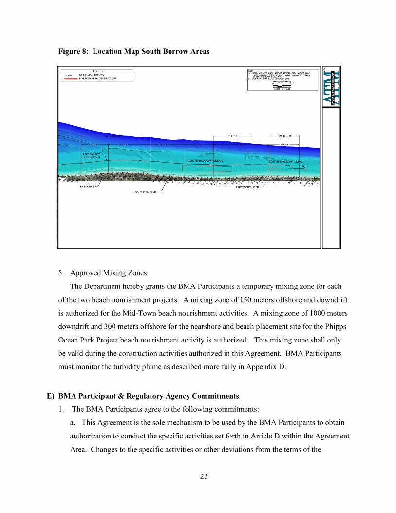
Figure 8: Location Map South Borrow Areas
5. Approved Mixing Zones
The Department hereby grants the BMA Participants a temporary mixing zone for each
of the two beach nourishment projects. A mixing zone of 150 meters offshore and downdrift
is authorized for the Mid-Town beach nourishment activities. A mixing zone of 1000 meters
downdrift and 300 meters offshore for the nearshore and beach placement site for the Phipps
Ocean Park Project beach nourishment activity is authorized. This mixing zone shall only
be valid during the construction activities authorized in this Agreement. BMA Participants
must monitor the turbidity plume as described more fully in Appendix D.
E) BMA Participant & Regulatory Agency Commitments
1. The BMA Participants agree to the following commitments:
a. This Agreement is the sole mechanism to be used by the BMA Participants to obtain
authorization to conduct the specific activities set forth in Article D within the Agreement
Area. Changes to the specific activities or other deviations from the terms of the
23

Agreement may require amendment of the Agreement as determined by the criteria set
forth in Article N. Permits within the Agreement Area previously issued by the
Department to the BMA Participants remain valid until the expiration date. However, in
the event permit conditions of existing permits conflict with the BMA permit conditions
in Appendix D, the BMA permit conditions shall prevail.
b. By signing this BMA, each Participant has certified to the Department that it has in
place internal environmental management systems or alternative internal controls
sufficient to implement this Agreement.
c. The BMA Participants agree to administer the cell-wide monitoring and mitigation
plans (for any new projects with impacts), as described in Appendix B.
d. The BMA Participants agree to fund the required cell-wide monitoring annually. Any
funding strategies are allowable if agreed upon by the Participants.
e. The BMA Participants agree to annually report to the Department the amount of
money spent to perform the projects identified in the Agreement and to comply with
conditions of the Agreement.
f. The Town of Palm Beach agrees to reduce stormwater discharge onto the beach and
dune system as described fully in Article F. Data from this effort shall be submitted to
the Department on an annual basis no later than November 30 each calendar year until
the 67 outfalls identified in Article F-4 are removed.
2. The Regulatory Agencies signing this Agreement agree to the following commitments:
a. Florida Department of Environmental Protection
i. Uphold the procedures of this BMA;
ii. Post annual cell-wide data and reports on the agency’s website and send
notification to interested parties;
iii. Host annual meeting with State and Federal Regulatory Agencies for data review
and adaptive management updates;
iv. Host annual meeting with Participants and stakeholders to present the data
collected from the monitoring effort; and,
v. Conduct the 5-year cell-wide hardbottom monitoring review, referenced in
Appendix B. Additionally, conduct post project regulatory review of Mid-Town
3-5 years following each nourishment event.
24

vi. Every five years the Department shall hold a public information-gathering forum
to report on data collected to date through the BMA process and receive public
comment on whether there is cause for the Agreement to be modified or
terminated. Notice of such forum shall be published the Department’s BMA
Website (http://www.dep.state.fl.us/beaches/pb-bma/index.htm) and the Florida
Administrative Register at least thirty (30) days prior to the forum. Notice shall
also be provided to the FWC, NMFS, USACE, FWS, and BMA Participants.
b. Florida Fish and Wildlife Conservation Commission (FWC)
i. By signing this document, the FWC does not abrogate its responsibilities under
the Florida Constitution, Florida Statutes and Administrative Code Rules, for
oversight and protection of public trust resources;
ii. The FWC agrees that it has conducted all the necessary evaluation to state that
each activity approved in this Agreement in Article D is consistent with Florida’s
Coastal Zone Management Program and will not adversely affect the conservation
of fish and wildlife, including endangered or threatened species or their habitats;
iii. The FWC agrees to review the annual turtle monitoring data and oversee the turtle
monitoring protocols in the Agreement;
iv. The FWC agrees that additional review is necessary for new projects or
amendments to the BMA that would affect wildlife;
v. The FWC agrees that additional evaluation of impacts to fish and wildlife and
consideration of adaptive management options are necessary in the event that
physical and biological monitoring reveals unanticipated impacts, or if additional
species are listed in the Florida Administrative Code;
vi. The FWC agrees to provide appropriate representatives to participate in informal
pre-application review meetings and Application Review Meetings identified in
Article H; and,
vii. The FWC agrees to conform to the timeframes set forth in this Agreement for
IPAs, Article H and I.
3. Regulatory agencies indicate their support of the BMA through submittal of a non-
binding support letter. These regulatory agencies include: U.S. Army Corps of Engineers,
25

Regulatory Branch; and National Marine Fisheries Service (NMFS). The support letter
indicates agreement with the following items:
i. Agree to use the same project-related regulatory data collected through the Cell-
Wide Hardbottom and Marine Turtle Monitoring Plans to perform their own
independent permit evaluations.
ii. Agree to provide appropriate representatives to participate in informal pre-
application review meetings and Application Review Meetings identified in
Article H.
iii. Agree to conform to the timeframes set forth in this Agreement for IPAs, Article
H.
F) Net Ecosystem Benefits
The Department determines and the BMA Participants acknowledge that the requirement to
provide net ecosystem benefits to the Agreement Area provides ecosystem benefits more
favorable than those that would be provided under current regulations. Net ecosystem benefits
will be satisfied through implementation of this Agreement. The Department and BMA
Participants agree that implementation of the Agreement will result in the following net
ecosystem benefits:
1. Improved Inlet Management
The BMA Participants agree to improve the transport of beach quality sand across Lake
Worth Inlet onto the eroding beaches located on the northern portion of Palm Beach Island.
The Florida Legislature recognizes that inlets interrupt or alter the natural drift of beach-
quality sand resources. Fla. Stat. § 161.141(2). Accordingly, the Legislature found that it is
in the public interest to replicate the natural drift of sand which is interrupted or altered by
inlets.
The BMA Participants will collaboratively manage the sand placement from the inlet
maintenance dredging conducted by the U.S. Army Corps of Engineers in order to better
service the downdrift beaches in need of bypassed material, which will ultimately lead to
more efficient and effective sand management. The groins in the BMA cell will also be
rehabilitated in order to stabilize the beaches and maximize the amount of placed sand
26

retained on erosive beaches. The BMA Participants will assess the best inlet and groin
management options to better maintain the bypassing effort to the south of the inlet.
This is a Net Ecosystem Benefit because while the Town of Palm Beach is currently
achieving its annual bypassing goals, maximum effectiveness of this bypassing is not being
achieved. The BMA Participants are implementing a solution that will improve the stability
of the beach dune system through more effective bypassing.
The Town of Palm Beach may provide additional net ecosystem benefits through
improvements of the sand transfer plant. Currently there is a sand transfer plant located on
the northern jetty of the Lake Worth Inlet operated by the Town of Palm Beach. This sand
transfer plant hydraulically pumps sand from the wide southern portion of Town of Palm
Beach Shores onto the eroding northern portion of Palm Beach Island. While this effort has
provided some relief to the northern eroding portion of Palm Beach Island, its function has
not been completely successful. Currently, beach quality sand from north of the inlet is only
placed in Reach 1 at R-76. This sand tends to build up in this location and not continue its
flow to the south because the inlet navigation improvements shelter this location from waves
and reduces littoral sediment transport. Despite sand bypassing from the transfer plant,
historical physical monitoring documents accretion of beaches in Reach 1 and generally
eroded beach conditions in Reach 2.
The Town of Palm Beach has been authorized to construct a new pump house facility
immediately adjacent to the existing bypass plant on the north jetty of the Lake Worth Inlet
and to construct an additional discharge pipeline. The new facility will house a booster pump
for an additional pipeline to transport material from the north jetty approximately 4,500 feet
south to an alternate discharge point near R-79 within Reach 2 in the Town of Palm Beach
where sand is expected to continue its natural sand transport south. The improved sand
transfer plant will result in fewer operational delays, as well as a greater area to bypass sand,
thereby maximizing operational efficiency. These improvements will enhance the ability of
the Town to transfer sand to the eroded beach and better replicate the littoral transport of
sand from north to south.
27

2. Cell-Wide Biological Hardbottom and Physical Monitoring
The BMA Participants agree to implement annual cell-wide physical and biological
monitoring of submerged hardbottom and a regular reporting of such findings. The BMA
Participants will follow agreed upon standard methodologies for data collection and analyses
as described in Appendix B. The monitoring plans will meet the state and federal regulatory
requirements for approved projects. This monitoring will also create a Net Ecosystem
Benefit by obtaining a more complete cell-wide understanding of hardbottom and sediment
variability.
Implementation of this plan will result in more efficient and cost-effective management
of hardbottom within the Agreement Area. Joint Coastal Permits issued through the
Department have typically required collection of physical and biological monitoring data
within the immediate area of the permitted project. By implementing cell-wide monitoring,
the BMA Participants and the Department will monitor the entire cell and gain a consistent
and comprehensive assessment of project performance, as well as a better understanding of
natural variation in the cell. The cell-wide biological monitoring will include specific
transects typically utilized to determine project impacts within the monitoring program.
However, the cell-wide monitoring and reporting program will also establish predictable and
systematic data collection methodologies over the entire cell and improve the evaluation of
coastal resources over the long-term. With this information, the BMA Participants and the
Department will be able to adaptively manage the resources in the Agreement Area. The
cell-wide approach will advance understanding of coastal ecosystems in general and improve
the quality of recommendations to enhance protection strategies for hardbottom and marine
turtle nesting habitats and other resources in this area and in other areas in the future.
The cell-wide physical and biological monitoring program will be implemented as
described in Appendix B1 and B3. Any deviation, other than those described in the adaptive
management section, from this methodology must be approved in advance through a formal
amendment of the Agreement.
3. Cell-Wide Sea Turtle Monitoring
The BMA Participants agree to implement cell-wide monitoring of sea turtle nesting
beaches on Palm Beach Island as part of the Agreement. The monitoring plans will meet the
28

state and federal regulatory requirements for approved projects. This monitoring will also
create a Net Ecosystem Benefit by obtaining a more complete cell-wide understanding of the
variability of sea turtle nesting. Implementation of this plan will result in more defensible,
efficient, and cost-effective management of sea turtles within the Agreement Area. Joint
Coastal Permits issued by the Department have typically required collection of sea turtle
monitoring data within the immediate area of the permitted project. The monitoring agreed
to in this plan will enable assessment of changes on project beaches relative to changes in
nesting of sea turtles on an island-wide scale.
Placement of sand on the shoreline, either through dune restoration or nourishment,
during beach management activities results in obvious alterations to the nesting substrate in
the project area. However, it is unclear whether these observed changes in sea turtle nesting
behavior affect overall reproductive success across the broader landscape that includes the
project site. Monitoring sea turtle nesting behavior on an island-wide basis in addition to
project-specific monitoring offers an opportunity to assess the influence of beach
management activities across a broader spatial and temporal scale within a framework that
includes fluctuations in sea turtle nesting that may occur independent of beach management
activities.
Direct impacts to marine turtles, their nests, and hatchlings during construction such as
avoidance of illuminated work areas and disorientation of adults and hatchlings from
adjacent beaches to lights at the construction site are typically limited in space and time.
Indirect impacts that occur over longer time periods due to the design and composition of
beach and dune fill, such as changes in profile and sediment composition must also be
identified and minimized to the degree practicable. Such impacts persist, and have the ability
to negatively impact nesting for several years after project construction. While decreases in
nesting and reproductive success are anticipated during and after project construction due to
engineered changes in the beach, monitoring focused within the project and on immediately
adjacent beaches may miss or mask other pervasive fluctuations in nesting that occur on an
island-wide basis independent of the project.
Cell-wide monitoring will better assess the spatial and temporal extent of sea turtle
response to beach management activities, and will help isolate possible root causes of
observed behaviors and identify the impact of spatially and temporally isolated beach
29

management activities on overall utilization of the Island by nesting sea turtles. With this
information, the BMA Participants and the Department will be able to adaptively manage
nesting habitat of sea turtles in the Agreement Area.
The cell-wide sea turtle monitoring program will be implemented as described in
Appendix B-2. Any deviation from this methodology must be approved in advance through
a formal amendment of the Agreement.
4. Outfalls Removal
Constructed many years ago, prior to the modern environmental regulations, there are
many private and public surface water runoff outfalls and discharges that currently direct
stormwater onto the beach and dune system. The Town of Palm Beach identified 67 public
outfalls/discharges (Appendix G) with a total annual output of 28.5 acre-feet (9.2 million
gallons per year). Water discharges can cause scour/erosion of the adjacent beach and dune
system, and may affect water quality and negatively influence sea turtle nests on the beach or
natural resources in the nearshore.
The Town of Palm Beach will implement a long-term program to redirect surface runoff.
The long-term program will include a phased capital improvement effort to improve the
Town of Palm Beach’s beach and dune system. Of the 67 identified discharges, 56 are
located along the North Ocean Boulevard seawall adjacent to the Palm Beach Country Club.
The North Ocean Boulevard seawall is scheduled for replacement in 2014. The outfalls will
be eliminated from the seawall. Modifications to the remaining 11 discharges, located within
Reaches 2 through 6, will include a ten year program to upgrade, remove or divert those
outfalls. Within ten years of the effective date of this Agreement, the Town of Palm Beach
will have removed all 67 public outfall/discharges.
Further, there are approximately 103 outfalls/discharges located within the Town of Palm
Beach that are located on private property. Town of Palm Beach staff will implement an
annual education campaign targeting all residents with outfalls/discharges on the beach and
dune system to consider actions to reduce or eliminate any influences. As redevelopment
occurs on properties with such outfalls/discharges, the Town of Palm Beach will require
owners and Palm Beach County will encourage owners to meet the State’s standard of
refraining from discharging onto the beach and dune system.
30

G) Avoidance, Minimization and Mitigation
Based on its evaluation of the projects listed in Article D, the Department determined that the
Town of Palm Beach has avoided and minimized impacts resulting from the projects to the
greatest extent practicable. Further, the Department does not anticipate direct or secondary
impacts associated with the listed projects beyond those impacts that have occurred and have
been or are being mitigated for in previously permitted projects. Of the projects approved at the
signing of the BMA, only the Mid-Town Project would have project-associated regulatory
transects established to verify the prediction of no impact (see Appendix B-1). The Phipps
Project and the discharge pipe extension have no associated “project specific transects” required
for reasonable assurance.
If new projects are implemented in the Agreement Area that have impacts which have not
already been permitted, the BMA Participants and the Department agree to mitigate those
impacts by implementing the procedures in the Palm Beach Island Beach Management
Agreement Hardbottom Mitigation Plan (Appendix B-1-C). Anticipated direct hardbottom
impacts (direct burial within the equilibrium toe of fill) will be mitigated for by the creation of a
functionally equivalent artificial reef. Mitigation will be at a 1:1.5 ratio of hardbottom buried to
artificial reef created. If the mitigation is performed ahead of impacts, the ratio will be lowered
to 1:1 hardbottom buried to artificial reef created. The created reef will be representative of the
hardbottom type impacted (i.e., reef material and location, water depth, relief). Unanticipated
hardbottom impacts (e.g., direct burial, temporal loss, community degradation, or recruitment
loss) from these projects will be recorded through biological monitoring and handled through
compliance and enforcement.
H) Individual Project Approval Process for In-Water Activities
A BMA Participant proposing to construct a project approved in the BMA must obtain an
Individual Project Approval (IPA) from the Department prior to commencement of any
construction activity for the projects approved in Article D.3.a. through e. (Lake Worth Inlet
Sand Transfer Plant, Midtown Beach Nourishment Project, and Phipps Ocean Park Beach
Nourishment Project, Groin Rehabilitation). The procedure outlined below is intended to
confirm that the project the BMA Participant is prepared to commence remains consistent with
this Agreement.
31

IPAs for in-water activities, activities in Article D.3.a. through e. authorized by this
Agreement, shall be conducted in compliance with Chapter 62B-49, F.A.C., including all
procedures contained therein, except as those procedures are modified in this Article.
1. Informal Pre-Application Process
A BMA Participant proposing to construct a project may request an informal pre-
application meeting with the Department to discuss a project on the list of activities approved
in Article D and clarify any necessary procedural and substantive criteria of the Agreement,
including the provisions of Chapter 62B-49, F.A.C. Representatives from FWC, USFWS,
NMFS, and the U.S. Army Corps of Engineers (Corps) will be invited to the pre-application
meeting. The BMA Participant proposing to construct a project agrees to provide sufficient
information on any procedural or substantive criteria that needs clarification. The pre-
application meeting does not commence the formal review of an IPA application. Pre-
application meetings may be scheduled as needed.
2. Formal Individual Project Review
To commence the review of an application for an IPA, the BMA Participant proposing to
construct a project approved under the BMA agrees to prepare an application using all of the
information identified in the Individual Project Approval Checklist (Appendix F-2). Upon
receipt of the application, the Department will schedule an Application Review Meeting to
occur two (2) weeks after receipt of the application. A processing fee shall accompany each
application in an amount consistent with the fee schedule set forth in Rule 62B-49.006,
F.A.C., with the exception that the BMA Participant proposing to construct a project will
only be required to pay 50% of the fees required under rules 62B-41.0085(3)(a),(b), and (c),
F.A.C. (rigid coastal structures, beach restoration, and construction and maintenance of inlets
respectively), which are incorporated by rule 62B-49.006(1), F.A.C., and attached in F-3.
The Department will invite representatives from the FWC, USFWS, NMFS and Corps to
the Application Review Meeting. The application shall be considered to be in draft form
until the day of the meeting, at which time the formal review of the application shall
commence and all times limits set forth in this Article shall begin.
32

The Department will send a Sufficiency Review Letter to the BMA Participant proposing
to construct a project within seven (7) days of the Application Review Meeting. The
Sufficiency Review Letter will indicate whether the application is complete or ask the BMA
Participant to resolve any errors or omissions that render the application incomplete. If the
BMA Participant provides a response to complete the application, the Department will
provide a Sufficiency Review Letter with 30 days of receipt of the response. If the BMA
Participant fails to respond within 60 days to a Sufficiency Review Letter that indicates the
application is not complete, the Department will deny the application.
Upon receipt of the complete application for IPA, including resolution items in the
Sufficiency Review Letter, the Department will have 60 days to review the completed
application for compliance with the terms of this Agreement. The review shall also consider
the Applicant’s history of compliance with previously issued permits and IPAs granted under
this Agreement as a factor in determining if reasonable assurance has been provided that the
terms of the Agreement as applied in the IPA will be met. A history of non-compliance with
previously issued permits, IPAs, or failure to comply with cell-wide commitments in this
Agreement may serve as the basis for project denial, modification, or the addition of specific
conditions, based on the nature, severity, and extent of the non-compliance.
If the application provides reasonable assurance that the project complies with the terms
of this Agreement, the Department shall approve the individual project, provide proprietary
authorization, and any necessary mixing zone by issuing an Individual Project Approval
Letter. Such approvals will include general conditions as set forth in Chapter 62B-49,
F.A.C., and included in Appendix C and specific conditions applicable to all projects as set
forth in Appendix D. If the application does not provide reasonable assurance that the
project complies with the terms of the Agreement, and the BMA Participant does not
withdraw or change the application, the Department will deny the application. Each letter
will include a point of entry for challenging the agency action. Denial of the application does
not prejudice the BMA Participant to propose a project that is consistent with the Agreement
or submitting an application pursuant to Chapter 62B-49, F.A.C.
The letter will also include a public notice of the agency action that the BMA Participant
proposing to construct a project shall publish in a newspaper of general circulation in Palm
Beach County, which publication shall be accomplished in the same manner as provided in
33

Rule 62-110.106(5), F.A.C. The Department will post notice of its agency action on its
website (http://www.dep.state.fl.us/beaches/pb-bma/index.htm).
The Department and the BMA Participant proposing to construct a project may agree
during any individual project review process to waive the time limits set forth in this Article.
Such an agreement must be memorialized in a separate written agreement document between
the Department and the BMA Participant who is waiving the time frame.
I) Individual Project Approval Process for Dune Construction
The BMA Participant wishing to construct a dune project must obtain an Individual Project
Approval (IPA) from the Department prior to commencement of any construction activity for the
projects approved in Article D, activity 4. (dune construction). The procedure outlined below is
intended to confirm that the dune project the BMA Participant is prepared to commence remains
consistent with this Agreement.
IPA for Dune Construction, activity 4., in Article D authorized by this Agreement shall be
conducted in compliance with Chapter 62B-33, F.A.C., including all procedures contained
therein, except as those procedures are modified in this Article.
1. Project Review and Approval
BMA Participants wishing to construct artificial dunes under this Agreement must meet
the design criteria in Appendix D. Prior to construction of an artificial dune, the BMA
Participant proposing to construct a dune shall contact the Department to schedule a meeting
on site with the Department’s Field Inspector. At the meeting the BMA Participant shall
provide the Department Field Inspector with a Dune and Backshore Berm Restoration and
Maintenance Checklist (Appendix F-1) and items required by the Checklist, including a
sample from the proposed sand source.
If the application provides reasonable assurance that the project complies with the terms
of this Agreement, the Department Field Inspector shall approve the individual project by
issuing an Individual Project Approval Letter. Such approvals will include general
conditions as set forth in Chapter 62B-33, F.A.C., and specific conditions applicable to all
dune construction projects as set forth in Appendix D. The letter of approval shall include a
point of entry for challenging the agency action. Such approval shall be posted
34

conspicuously during construction of the artificial dune. The Department will post notice of
its agency action on its website (http://www.dep.state.fl.us/beaches/pb-bma/index.htm).
The Department shall deny proposed individual projects not meeting terms of this
Agreement at the meeting. This denial does not prejudice the applicant to propose a new
dune design that will meet the design criteria in Appendices D and F-1 or submitting an
application to the Tallahassee Office of the Department of Environmental Protection,
Division of Water Resource Management for an alternate dune construction design pursuant
to Chapter 62B-33, F.A.C.
J) Preservation of Third Party Rights
This Agreement is not intended to alter or modify the rights of third parties to challenge
agency actions. Execution or formal amendment of this Agreement constitutes agency action.
Any Florida corporation not for profit which meets the requirements of subsection 403.412(6),
F.S., and any person whose substantial interests will be determined or affected by the Agreement
may petition the Department for a formal administrative hearing pursuant to section 120.569 or
120.57, F.S., as set forth in the attached Notice of Rights, to challenge the provisions of this
Agreement.
If the Department proposes to issue an IPA pursuant to Article H or I of this Agreement, any
Florida corporation not for profit which meets the requirements of subsection 403.412(6), F.S.,
and any person whose substantial interests will be determined or affected by IPA under the
Agreement may petition DEP for a formal administrative hearing pursuant to section 120.569 or
120.57, F.S., as set forth in the Notice of Rights attached to the IPA. The scope of a challenge to
an IPA or denial is limited to whether the agency action complies with this Agreement and any
agency action outside the approvals of this Agreement taken in the IPA. Agency action
previously subject to challenge or administrative review will not be subject to challenge at the
time of IPA.
K) Term of Agreement
This Agreement shall be perpetual, unless modified according to Article N or terminated
according to Article P.
35

Every five (5) years starting from the effective date of the Agreement, the Department, FWC,
and BMA Participants will evaluate the Agreement to determine if amendments are necessary to
facilitate its goals. All such amendments will be subject to the requirements of Article N. Every
five years the Department shall hold a public information-gathering forum to report on data
collected to date through the BMA process and receive public comment on whether there is
cause for the Agreement to be modified or terminated. Notice of such forum shall be published
to the Department’s BMA Website (http://www.dep.state.fl.us/beaches/pb-bma/index.htm) and
the Florida Administrative Register at least thirty (30) days prior to the forum. Notice shall also
be provided to the FWC, NMFS, USACE, FWS, and BMA Participants.
L) Effective Date
The effective date of this Agreement shall be the date on which the last entity identified as a
signatory on the signature page below executed the Agreement.
M) Notices
1. Any notices between the BMA Participants and the Department shall be considered
delivered when sent via email with a “read receipt notification” or posted by Certified Mail,
return receipt requested, overnight courier service, delivered in person to the Project
Managers at the addresses below.
2. Any and all notices shall be delivered to the parties at the following addresses:
BMA PARTICIPANTS
Town of Palm Beach
Public Works Department
Post Office Box 2029
Palm Beach, Florida 33480-
2029
DEPARTMENT
Department of Environmental Protection
Division of Water Resource Management
3900 Commonwealth Blvd., MS 300
Tallahassee, Florida 32399-3000
(850) 488-7708
36

Palm Beach County
Department of Environmental
Resource Management
2300 North Jog Rd.
West Palm Beach FL, 33411-
2741
FWC
Florida Fish and Wildlife Conservation
Commission
620 South Meridian Street
Tallahassee, Florida 32399-1600
Any changes to the contact information above must be provided in writing; however, such
change does not have to be a formal amendment to this Agreement.
N) Amendments and Updates
1. This Agreement represents the entire Agreement between the Department, FWC, and the
BMA Participants. Any substantial alterations, variations, changes, modifications, or
waivers of provisions of this Agreement shall only be valid when they have been reduced to
writing, duly signed by the Department, FWC, and each of the BMA Participants hereto, and
attached to the original of this Agreement, unless otherwise provided herein. This
Agreement may be modified at any time by written amendment approved by the Department,
FWC, and all BMA Participants. Amendments must be consistent with the provisions of
sections 403.075 and 403.0752, F.S. Such amendments must also meet the noticing
requirements of subsection 403.0752(8), F.S. Notice of such amendments shall be published
the Department’s BMA Website (http://www.dep.state.fl.us/beaches/pb-bma/index.htm), in a
newspaper of general circulation in Palm Beach County, and the Florida Administrative
Register at least thirty (30) days prior to the agency action.
a. Substantial alterations, variations, changes, modifications, or waivers include, but are
not limited to:
i. Addition of new projects into the Agreement;
ii. Changing the location of existing projects such that additional impacts are
anticipated;
iii. Changing project approval procedures or criteria for issuance;
iv. Changing monitoring or mitigation requirements necessitated by the discovery of
additional impacts;
37

v. Changing or eliminating net ecosystem benefits.
b. The following items are not considered substantial alterations, variations, changes,
modifications, or waivers and do not require written and signed amendment of the
Agreement:
i. Addition of supporting documentation;
ii. Changes made pursuant to a federal environmental permit or authorization;
iii. Revision of an individual project that does not require a substantial alteration of
the project authorized in Article D of this Agreement;
iv. Changes to the project that reduce the potential for adverse impacts to the coastal
system;
v. Changes to a monitoring plan that better captures project impacts;
vi. Changes to interlocal funding strategies; and
vii. Changes though adaptive management strategies that do not increase the potential
for adverse impacts or lower reasonable assurance provided by the BMA
Participants for the permitted projects.
2. Formal amendment under this section is required in the event a BMA Participant wishes
to add a new project to the Agreement.
a. Prior to adding a new project, the Department shall hold a public information-
gathering forum to receive public comment on the proposed additional project. Notice of
such forum shall be published to the Department’s BMA Website
(http://www.dep.state.fl.us/beaches/pb-bma/index.htm) and the Florida Administrative
Register at least thirty (30) days prior to the forum. Notice shall also be provided to the
FWC, NMFS, USACE, USFWS, and BMA Participants.
b. The BMA Participant proposing the new project shall:
i. Identify potential adverse impacts to the coastal system;
ii. Demonstrate that the proposed project is consistent with the Agreement;
iii. Demonstrate that the proposed project will not detract from the net ecosystem
benefits;
iv. Demonstrate how the proposed project will coordinate with existing projects;
v. Propose any additional mitigation that would be required under this Agreement;
and
38

vi. Meet all substantive regulatory criteria
3. Adaptive Management Plan
The Department and BMA Participants agree to adaptively manage the projects in the
Agreement Area, using a similar approach as described by the U. S. Department of the
Interior. The Department of the Interior recognizes the importance of natural variability and
uses adaptive management to promote flexible decision making based on an iterative learning
process. For the purposes of the BMA, adaptive management will be a means to improve
effective decision-making and enhance protection of coastal resources. The Department and
the BMA Participants agree to adaptively manage by annually:
a. Determining compliance with terms of the Agreement;
b. Reviewing monitoring data and survey methods with the assistance of the academic
community to implement adjustments to improve the monitoring plans and add scientific
rigor;
c. Reviewing project performance to determine if adjustments to the project design are
necessary to improve upland protection, address sea level rise (Williams, B. K., R. C.
Szaro, and C. D. Shapiro, 2009. Adaptive Management: The U.S. Department of the
Interior Technical Guide. Adaptive Management Working Group, U.S. Department of
the Interior, Washington, DC.), and reduce environmental impacts;
d. Responding to new concerns (if any) of BMA Participants or supporters and adjusting
the monitoring plans accordingly;
e. Reviewing innovative technologies and new research studies or methodologies for
possible impact on the BMA goals, polices, and procedures;
f. Obtaining or requesting third party review of annual monitoring data collected under
the BMA;
g. Reviewing any new State and / or Federally listed species and critical habitat areas,
and updating any regulatory required protection and minimization measures; and
h. Conducting an annual poll (i.e. from turtle monitoring personnel) to determine if any
nesting birds or bird colonies have been discovered within the cell. Notification of poll
results shall be sent to FWC for evaluation.
39
The Town of Palm Beach will update the list of groins to be repaired, rehabilitated, or
removed every 5 years for groins in Reaches 2-6. This will be incorporated as necessary.
The dune condition areas identified in Article D.3 may change over time. An updated
dune table will be provided every 5 years as an adaptive management strategy.
O) Emergency Situations
If a force majeure occurs that causes delays or the reasonable likelihood of delay in the
fulfillment of the requirements of this Agreement, the affected BMA Participant shall promptly
notify the Department orally. Within seven (7) days, the BMA Participant shall notify the
Department and FWC in writing of the anticipated length and cause of the delay, the measures
taken or to be taken to minimize the delay and the BMA Participant’s intended timetable for
implementation of such measures. If the parties agree that the delay or anticipated delay was
caused, or will be caused by a force majeure, the Department may, at its discretion, extend the
time for performance under this Agreement for a period of time equal to the delay resulting from
the force majeure upon execution of an amendment to this Agreement. Such agreement shall be
confirmed by letter from the Department accepting, or if necessary, modifying the extension. A
force majeure is an act of God, strike, lockout, or other industrial disturbance, act of the public
enemy, war, blockade, public riot, lightning, fire, flood, explosion, failure to receive timely
necessary third party approvals, and any other cause, whether of the kind specifically enumerated
herein or otherwise, that is not reasonably within the control of the BMA Participant and/or the
Department. Failure to perform by the BMA Participant’s consultant(s) or subcontractor(s) shall
not constitute a force majeure event.
New coastal construction projects in response to emergency will require separate authorization.
P) Termination/Exit
1. Department Termination
The Department may terminate or request renegotiation of this Agreement with any
individual BMA Participant by giving thirty (30) days prior written notice to the BMA
Participant if the Department demonstrates that:
40
a. There has been a material change in conditions which existed at the time of the
original Agreement such that the intended net ecosystem benefits are not being, or may
not reasonably be expected to be, achieved through continuation of the Agreement.
b. The BMA Participant refused to allow public access to all documents, papers, letters,
or other material made or received by the BMA Participant in conjunction with this
Agreement, unless the records are exempt from S. 24(a) of Article I of the State
Constitution and S. 119.07(1), Florida Statutes.
c. The BMA Participant is in material breach of the terms of the Agreement.
2. Nothing in this paragraph shall preclude the Department from taking appropriate
enforcement action in lieu of or in combination with termination of the Agreement for
violations of this Agreement or any IPA issued hereunder.
3. BMA Participant Termination
A BMA Participant or FWC may terminate its individual obligation under this
Agreement for any reason by giving thirty (30) days prior written notice to the DEP and other
BMA Participants as provided in Article M, provided that the mitigation commitments
identified in the IPAs are fulfilled or agreements are entered into to ensure fulfillment.
Upon termination of the Agreement or termination by an individual BMA Participant,
previously issued project approvals shall remain in effect for the duration of such approval.
The authorized projects will transition to the typical permit expiration date, beginning from
the execution of the IPA for that particular project. For the projects initially authorized by
the BMA, this would equal to a 5-year permit for the Sand Transfer Plant, 5-year permits for
groin rehabilitations, a 10-year permit for the Mid-Town Nourishment Project, and a 15-year
permit for the Phipps Ocean Park. BMA Participants holding such IPAs shall continue to be
subject to the General and Specific Conditions (Appendices C and D) included in the IPAs
for the permitted life of the project. Individual BMA Participants who elect to terminate
under this Article may not utilize the permitting procedures found in Article H and I of this
Agreement.
Following the exit of any one BMA Participants, the remaining BMA Participants and the
Department must meet to determine if changes to the Agreement are necessary to ensure
compliance with the terms of the Agreement that the Net Ecosystem benefits described in
41

Article F can continue to be achieved. Such changes may require formal amendment of the
Agreement.
Q) Venue and Severability
This Agreement has been delivered in the State of Florida and shall be construed in
accordance with the laws of Florida. Wherever possible, each provision of this Agreement shall
be interpreted in such manner as to be effective and valid under applicable law. If any provision
of this Agreement shall be prohibited or invalid under applicable law, such provision shall be
ineffective to the extent of such prohibition or invalidity, without invalidating the remainder of
such provision or the remaining provisions of this Agreement. Any action hereon or in
connection herewith shall be brought in Palm Beach County, Florida. No delay or failure to
exercise any right, power or remedy accruing to either party upon breach or default by either
party under this Agreement, shall impair any such right, power or remedy of either party. Nor
shall such delay or failure be construed as a waiver of any such breach or default, or any similar
breach or default thereafter.
REMAINDER OF PAGE INTENTIONALLY LEFT BLANK
42

43
R) Signatures IN WITNESS THEREOF, the parties, by and through the undersigned duly authorized
representatives, have executed this Agreement on the dates set forth below.
Mayor, Town of Palm Beach
Date:
Steven L. Abrams
Mayor, Palm Beach County
Date:
Jeff Littlejohn
Deputy Secretary of Regulatory Programs
Florida Department of Environmental
Protection
Date:
Eric Sutton
Assistant Executive Director
Florida Fish & Wildlife Conservation
Commission
Date: