paleoseismological data from a new trench across the el ... · stefano pucci, alexander radulov,...
TRANSCRIPT

Key words paleoseismicity – trenching – normal fault –Catalan Coastal Ranges – El Camp Fault
1. Introduction
Paleoseismologic methods developed inhigh seismicity areas for high slip rate faults areincreasingly used for improving the calcula-tions of seismic hazard on faults with very lowslip rates (< 0.1 mm/yr). This is the case ofsome fault systems in Europe, such as the Rhine
763
ANNALS OF GEOPHYSICS, VOL. 46, N. 5, October 2003
Paleoseismological data from a new trench across the El Camp Fault
(Catalan Coastal Ranges, NE Iberian Peninsula)
Hector Perea (1), Paula M. Figueiredo (2) (3), Jesús Carner (1), Stefano Gambini (4), Kirsty Boydell (5) (1)Departamento Geodinàmica i Geofísica, Universitat Barcelona, Spain(2) LATTEX, Laboratório de Tectonofísica e Tectónica Experimental,
Faculdade de Ciências da Universidade de Lisboa, Portugal(3) ICTE, Instituto de Ciências da Terra e do Espaço, Universidade de Lisboa, Portugal
(4) School of Earth Sciences, The University of Leeds, U.K.(5) Department of Civil and Environmental Engineering, London, U.K.
and participants in the Europaleos coursePaola Albini, Pedro Alfaro, Raquel Amores, Ramon Arrowsmith, Kuvvet Atakan, Milos Bavec,Kelvin Berryman, Tamer Yigit Duman, Khalilallah Feghhi, Matthieu Ferry, Alessandro Fontana,
Chrysa Gountromichou, Robert Hus, Juan Miguel Insua, Ramon Julià, Fidel Martín, Eulàlia Masana,Mustapha Meghraoui, Vasso Mouslopoulou, Bruno Pace, Niko Palyvos, Daniela Pantosti, Gwendolyn Peters,
Stefano Pucci, Alexander Radulov, José Sánchez-Cabañero, Pere Santanach, Gordon Seitz,Yonathan Shaked, Dimitra Tsoukala and Gulsen Ucarkus
AbstractThe El Camp Fault (Catalan Coastal Ranges, NE Iberian Peninsula) is a slow slipping normal fault whoseseismic potential has only recently been recognised. New geomorphic and trench investigations were carried outduring a training course across the El Camp Fault at the La Porquerola alluvial fan site. A new trench (trench 8)was dug close to a trench made previously at this site (trench 4). With the aid of two long topographic profilesacross the fault scarp we obtained a vertical slip rate ranging between 0.05 and 0.08 mm/yr. At the trench site,two main faults, which can be correlated between trenches 8 and 4, make up the fault zone. Using trench analysisthree paleoseismic events were identified, two between 34.000 and 125.000 years BP (events 3 and 2) and anoth-er event younger than 13 500 years BP (event 1), which can be correlated, respectively, with events X (50.000-125.000 years BP), Y (35.000-50.000 years BP) and Z (3000-25.000 years BP). The last seismic event at the LaPorquerola alluvial fan site is described for the first time, but with some uncertainties.
Mailing address: Dr. Hector Perea, UniversitatBarcelona, Departamento Geodinàmica i Geofísica, ZonaUniversitària de Pedralbes, Barcelona 08028, Spain; e-mail:[email protected]

Graben, the Catalan Coastal Ranges and theBetic Cordillera. In fact, the recognition of theseismogenic characteristics of a fault, i.e. theevaluation of its slip rate, the size of the maxi-mum expected earthquake and the age of themost recent surface faulting earthquake cansubstantially change the perception of seismichazard in regions traditionally considered to bestable or not very active.
The «Europaleos field training course inpaleoseismology» focused on the El Camp Fault(Catalan Coastal Ranges, NE Iberian Peninsula)and was held in Cambrils (Spain) in February2001. The aim of this course was to providetraining for young researchers in paleoseismology.The course centred on the El Camp Fault for the following reasons: a) earlier studies havedemonstrated its potential for paleoseismic in-vestigation; b) some uncertainties concerningthe fault geometry and its seismic behaviour re-mained to be resolved; c) it is a good exampleof a low slip rate fault that could be encounter-ed in other parts of Europe and around theMediterranean, and d) the area is characterisedby high seismic vulnerability. This paper seeksto gain an insight into the slip rate and paleo-seimic history of the fault, account for change inthe scarp direction visible at the trench site andto present the results obtained during the Euro-paleos course.
2. The El Camp Fault
The El Camp Fault is located on the south-eastern flank of the Catalan Coastal Ranges(fig. 1) which are bounded by the Valènciatrough basin on the west. The Catalan CoastalRanges are characterised by an en échelon arrayof NE-SW faults, where the main faults arelistric, dip to the SE and have the detachmentlevel at a depth of 15 km (Roca and Guimerà,1992; Roca, 1996). The Catalan Coastal Rangesare the result of an E-W extension, which af-fected the eastern part of the Iberian Peninsuladuring the Neogene (Mauffret et al., 1973;Fontboté et al., 1990; Banda and Santanach,1992; Roca and Guimerà, 1992; Roca, 1996).This extension has been interpreted as a productof an extensional back-arc basin related to the
Apennine subduction (Doglioni et al., 1997,1999; Gueguen et al., 1998). Earlier studies onthe Catalan Coastal Ranges suggest that theseranges have been in a post-rift stage with weaktectonic activity since the middle Miocene(Roca and Guimerà, 1992; Roca, 1996).
The El Camp Fault is made up of two en éche-lon faults (north and south segments). From com-mercial and deep seismic profiles, it has beenshown that the El Camp Fault is a normal fault,with a dip of 60° and the main detachment levellocated at 13-15 km depth (Roca, 1992; Roca andGuimerà, 1992; Sàbat et al., 1997). The El CampFault constitutes the north-western limit of the ElCamp basin. Near the town of Reus, the detritalsedimentary infill of the El Camp basin has athickness of 1400-2000 m, which extends fromthe Miocene to the present time (Nuñez et al.,1980; Medialdea et al., 1986).
The El Camp Fault has not shown signifi-cant historical or instrumental seismic activity.However, recent paleoseismologic studiesbased on detailed geomorphological and trenchanalyses have shown that the El Camp Fault isactive, particularly its southern segment. This
764
Hector Perea, Paula M. Figueiredo, Jesús Carner, Stefano Gambini, Kirsty Boydell and participants in the Europaleos course
Mediterranean SeaEl Camp FaultStudied Area
Neogene basins
Faults under Neogene extension
Pyrenees
Catalan Coastal Ranges
1° E 2° E 3° E
42°N
41° N
Barcelona
Tarragona
Valènc
iatro
ugh
Fig. 1. Location maps: a) location of the CatalanCoastal Ranges within the Iberian Peninsula. Themap shows the Neogene basins and the faults withNeogene extension; b) Location of the El CampFault within the Catalan Coastal Ranges. The mapshows the en échelon array of NW-SE Neogenelistric faults in the Catalan Coastal Ranges.
ba
segment is approximately 24 km long, bearingin mind that the fault extends under the sea fora distance of 10 km. The segment is charac-terised by: a) a slip rate ranging between 0.02and 0.08 mm/yr; b) surface faulting earthquakesof Mw = 6.7 maximum magnitude; c) an averagerecurrence interval of 30.000 years, and d) theoccurrence of the last event 3000 years ago(Masana, 1995, 1996; Masana et al., 2000,2001a,b; Santanach et al., 2001). Seven trench-es located at different sites in the southern segment of the El Camp Fault enabled theseauthors to describe three seismic events duringthe last 125.000 years: event X, event Y andevent Z. Event X, between 125.000 and 50.000years BP, has been clearly described at two sites(site of trenches 1 and 2 and site of trench 4).Event Y, between 50.000 and 35.000 years BP,has only been described at the site of trench 4.Event Z, between 25.000 and 3000 years BP,has been described at two sites (at trenches 1and 2 - strongly based - and at trench 3).
3. Geomorphologic and topographic survey
The geological and geomorphological study ofthe southern part of the El Camp basin (fig. 2)reveals the presence of recent alluvial fans of fourgenerations: G1, G2, G3 and G4 (Villamarín et al.,1999; Santanach et al., 2001), which were mappedand surveyed in the field during Europaleos. Fansbelonging to the G2 and G3 generations stretchfrom the mountain range to the sea, whereas thosecorresponding to the G4 generation are located at the foot of the mountain range or in the low-lands between the fans of the older generations.According to different dating methods (U/Th, ther-moluminescence, paleomagnetic studies and cor-relation between different fan generations and sealevel highstands), minimum ages of 300.000 and125.000 years have been attributed to the top of theG2 and G3 generations, respectively (Villamarínet al., 1999; Santanach et al., 2001), the G4 gener-ation being younger than 125.000 years in age. Theoldest fans belonging to the G1 generation werenot considered in this study since they do not inter-act with the fault where it is exposed.
The geomorphological map (fig. 2) shows adiscontinuous fault scarp offsetting alluvial fans
belonging to the G2, G3 and G4 generations.The El Camp Fault scarp offsets the G4 gener-ation fans between the La Porquerola and theLes Planes fans and south of the Les Planes fan.These observations indicate that this segmentof the fault has been active during the last125.000 years. For logistical reasons, we fo-cused on one portion of the La Porquerola fan,where the fault affects the top of the G3 ge-neration fan. This fan is highly cemented andtherefore difficult to erode in contrast to theunconsolidated materials in the lower part ofthe scarp. Consequently, the scarp is clearlyvisible at the surface and a change in the direc-tion is recognisable. The scarp is the result of anormal fault-propagation fold with a smallscarplet at the bottom. Locally, a small wallconstructed along the foot of the scarp operatesas a sediment trap and has produced some sharpmorphologies that are visible on the trenchwalls. To the NE of trench 4, the scarp shows achange in direction close to a gully that is en-trenched in the scarp.
Using a total station (Leica 1700), we madea microtopographic map of the selected area (fig.3) and five topographic profiles. This informa-tion together with the geomorphology helped usto select the most favourable site for trenching.We decided to dig the trench in the zone wherethe fault scarp changes its direction (fig. 3) in anattempt to determine whether the change in thescarp direction was due to a change in the faultdirection or to erosion evidenced by the smallgully located there. In addition, the location ofthe new trench in the vicinity of the gully wouldenable us to obtain a more complete section ofrecent sediments on the downthrown wall than at trench 4. Thus, the possibility of detecting themost recent paleoseismic event, which had notbeen observed at this site, is greater.
Only two topographic profiles (fig. 4) werelong enough to obtain a preliminary evaluationof the slip rate at this location. The offset of the125.000 years fan surface measured in the pro-files is between 6.7 and 10.5 m. This provides amaximum vertical slip rate between 0.05 and0.08 mm/yr. Although these results are consis-tent with the slip rates obtained in earlier stud-ies on the El Camp Fault, which vary from 0.02to 0.08 mm/yr (Masana, 1995, 1996; Masana
765
Paleoseismological data from a new trench across the El Camp Fault (Catalan Coastal Ranges, NE Iberian Peninsula)

Hector Perea, Paula M. Figueiredo, Jesús Carner, Stefano Gambini, Kirsty Boydell and participants in the Europaleos course
Fig. 2. The El Camp basin geomorphological map (modified from Masana et al., 2001b). Location is shown infig. 1. The map shows the distribution of the different alluvial fan generations as well as the zones where thefault scarp intersects the different alluvial fans.
Montroig
LesPlanes Casalot
L’Hospitaletde l’Infant
Almadrava
Rifà CreekErmo t
Miami
Porquerola
Creek
MontroigAlluvial Fan
PorquerolaAlluvial Fan
Les PlanesAlluvial Fan
LlastresC
reekTrench
Site
TR6
TR5
TR8
TR4
TR1TR2
TR3
TR7
0°55 E 1°00 E
41°05 N
41°00 N
Fluvial channel
Coastal scarp
Triangular facet
Fault scarp
Trench site
Alluvial fan generation 4 (G4)
Alluvial fan generation 3 (G3)
Alluvial fan generation 2 (G4)
Alluvial fan generation 1 (G1)
Substratum0 5 km
TR7
766

et al., 2000, 2001a,b; Santanach et al., 2001),the 125.000 years fan surface offset obtained bythese authors in the same zone was 6.5 m,which is more similar to the lower values ob-tained from our profiles. Therefore, the lowerslip rate would be more realistic. On the as-sumption that the fault is purely normal with adip of 60° at depth, a dip slip of 0.06 to 0.09mm/yr is calculated.
4. Trench analysis
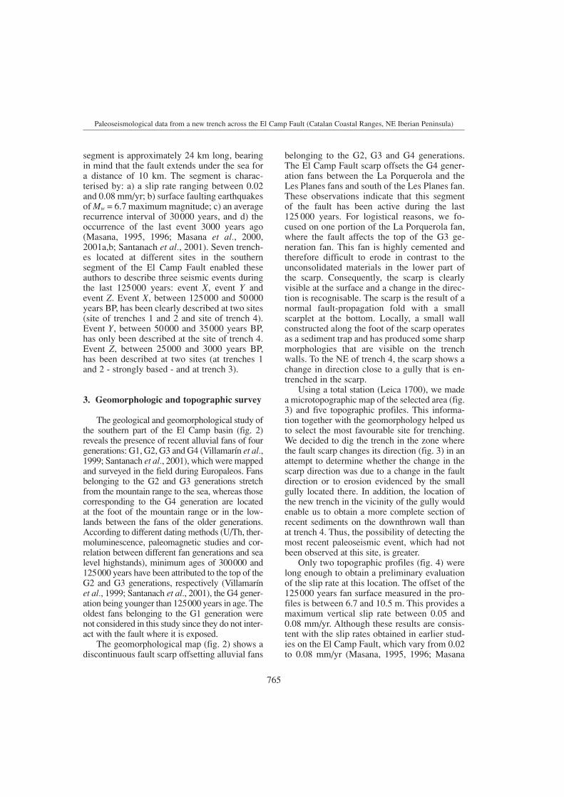
The trench dug through the scarp located atthe La Porquerola fan (fig. 5) was the eighthtrench dug along the El Camp Fault (Masana et al., 2000, 2001a,b; Santanach et al., 2001).The trench had a WNW-ESE orientation, alength of approximately 23 m and a depth ofapproximately 6 m. The trench 8 logs (fig. 6)show a succession of sedimentary layers, con-glomerates and gravels with different degreesof calcrete development. In the fault zone, thesediments are strongly weathered because offluid circulation through the faults, cracks and
Paleoseismological data from a new trench across the El Camp Fault (Catalan Coastal Ranges, NE Iberian Peninsula)
900 950 1000 1050 1100
850
900
950
1000
1050
1100
A
A
B
B
Trench 8
Profile 1
Profile3
0 50 100
Easting (m)
Nor
thin
g(m
)
II
II
II
II
II
II
II
II
II
II
II
II
II
II
Trench 4
-20 0 20 40 60 80 100 120 140 160 180 200Distance along profile (m)
88
92
96
100
104
Re
lativ
eel
evat
ion
(m)
-20 0 20 40 60 80 100 120 140 160 180 200Distance along profile (m)
88
92
96
100
104
Re
lativ
eel
evat
ion
(m)
9.1 m
7.7 m
A '
10.5 m
6.7 m
B
Trench 8
A
'B
Profile 1
Profile 3
Fig. 3. Microtopographic map of the trench site. Themap shows the location of trenches 8 and 4 and thelong profiles 1 and 3. The fault trace is also shown.The contour line interval is 0.5 m.
Fig. 4. Topographic profiles 1 and 3. A maximum and a minimum offset are plotted for each profile, taking intoaccount that the original fan slope surface could correspond to the surface on the downthrown (dotted line) orupthrown block (dashed line). The position of trench 8 is projected on profile 1. The location of the two profilesis shown in fig. 3. The vertical scale is exaggerated.
767
ture F2 has a subhorizontal dip and affectsunit F. F2 is an open fracture produced by adip slip along a normal fault (F1) and by theobstruction of the shallower part of the down-thrown block of this fault (Santanach et al.,2002). This kind of movement could haveproduced the opening of the hollow visible atthe trench along F2. The subsequent collapseof the obstructed part could have closed thehollow and could have produced a «reverse»fault geometry (fig. 8). Two minor faults arealso present, F3 and F4, the former beingmore clearly defined than the latter. Fault F3,a small antithetic fault, affects the hard layerlocated at the top of unit K with a maximumoffset of 20 cm. F4 is defined by the 60 cmoffset at the top of unit K, despite being badlyconstrained at lower levels. Unit J shows a mix-ture of materials, and clasts with a vertical pre-ferred orientation, which could be the result ofthe F4 movement.
One question we attempted to answer withthe opening of the trench was whether thechange in the scarp direction is due to: a) ashift in the direction of the fault, or b) to theerosion of the scarp. The analysis of the rela-tionship between F1, the main fault, and thesurface scarp, at trench 8, shows that thechange in the scarp direction is attributed tothe shift in the fault direction since the scarpfollows the fault direction (fig. 6). However,erosion controls the trench sedimentary archi-tecture and could highlight the change in thescarp direction.
Eight samples were collected for radiocar-bon dating. Only three of them contained suf-ficient material to be dated and only two(ERT8-2 and ERT8-6) provided a measured age(table I). Samples ERT8-2 (charcoal) andERT8-6 (a shell) were collected from unit L1,ERT8-2 near the top of the unit and ERT8-6near the limit between L1 and L. These datingsindicate that unit L1 was deposited between34.000 and 13.000 years BP. The other avail-able age constraint is the age of the top of theG3 generation (Villamarín et al., 1999).Therefore, the top of unit F is ca. 125.000 yearsold and all the units exposed on the upthrownblock are the same age or older with the excep-tion of M, which is the most recent unit.
768
Hector Perea, Paula M. Figueiredo, Jesús Carner, Stefano Gambini, Kirsty Boydell and participants in the Europaleos course
Fault Fault
Fig. 5. Trench 8 photograph taken from the south-east. The people in the photograph are on the up-thrown block of the fault.
hollows, which hinders the distinction betweenthe different layers (fig. 7).
On the upthrown block, units B, C, D andF are planar and sub-parallel to each other.Only unit F, which corresponds to the top ofthe G3 generation alluvial fan, can be followedacross the fault zone. On the downthrownblock, seven units (G, H, J, K, L, L1 and M)overlie unit F near the scarp, but F appears atthe surface again at a distance of approximate-ly 40 to 50 m from it. Thus, units G, H, J, K,L, L1 and M infill a local depression producedby the fault movement. The geometry of thesedimentary units on the downthrown block ismore complex than on the upthrown block.Units H to M cover part of the eroded scarpproduced by the faulting and bending of unit F.The geometrical relationships between theselithological units will be discussed below interms of paleoseismic events.
The fault zone is composed of a fault (F1)and a fracture (F2). Fault F1 is located alongunit W2 and offsets units B, C, D and F. Thefault plane has a subvertical attitude or dipsstrongly to the WNW (fig. 6). The offset topof unit F along F1 on the south wall shows aburied scarp that is 1.3 m high. However, thisis the minimum offset since the scarp hadprobably been eroded. To the east of F1, frac-

Paleoseismological data from a new trench across the El Camp Fault (Catalan Coastal Ranges, NE Iberian Peninsula)
Fig. 6. Logs of the trench 8 walls.
Unit B - Unconsolidated, well sorted sitly-clay, yellow-brown in colour, inclu-dingsome centimetre size carbonaticclasts.
Unit C - Strongly cemented, poorly sorted, matrix-supported conglomerate.Clasts are carbonatic, angular to subangular and range from a few centimetersto a few decimeters in size. Matrix is silty and reddish in colour.
Unit D - Poorly consolidated, well sorted, very fine sandstone reddish incolour, including some centimeter-size carbonatic clasts.
Unit F - Strongly cemented, poorly sorted, matrix-supported conglomerate.Clasts are carbonatic, subangular to subrounded and range from a few cen-timeters to a few decimeters in size. Matrix is silty and reddish in colour.
Unit W1 - Poorly cemented and sorted, matrix-supported conglomerate.Clasts are carbonatic, subangular to subrounded, and range from a few cen-timeters to a few decimeters in size. Matrix is silty and is light-yellow in colour.
Unit W2 - Poorly cemented and sorted, matrix-supported conglomerate.Clasts are carbonatic, angular to subangular, and centimetric in size. Matrixis silty and is pink in colour.
Unit G - Moderately consolidated, poorly sorted, matrix-supported gravel.Clasts are carbonatic, subangular to subrounded and centimetric in size.Matrix is silty and light brown in colour.
Unit H - Poorly consolidated and sorted, matrix-supported gravel. Clastsare carbonatic, subangular to subrounded and centimetric in size. Matrix issilty-clay and brown-orange in colour.
Unit J - Poorly consolidated and sorted, matrix-supported gravel. Clasts arecarbonatic, subangular to subrounded and centimetric in size. Matrix is siltyand brown-orange in colour.
Unit K - Poorly consolidated and sorted, matrix supported gravel. Clastsare carbonatic, subangular and range from a few centimeters to a few deci-meters in size. Matrix is silty and brown in colour. At top there is a hard layer.
Unit L - Unconsolidated, poorly sorted, matrix-supported gravel. Clasts arecarbonatic, subrounded and range from a few centimeters to a few deci-meters. Matrix is silty and reddish-orangein colour.
Unit L1 - Unconsolidated, well sorted, fine sandstones reddish-orange incolour, including some centimeter-size carbonate clasts.
Unit M - Unconsolidated, brown silt, including few centimeter-size (max. 2cm) carbonate clasts. At the top there is 10 cm width actual soil.
Fault
Possible fault and fault direction
Hollow
769

5. Paleoseismic events
At trench 8 we found evidence of at leastone individual surface-faulting earthquake. Fur-thermore, evidence for two more events willbe discussed. Briefly, we found evidence for
three possible events (fig. 6): a) event 1 at the topof L1 (uncertain); b) event 2 at the top of K(good), and c) event 3 at the top of H (uncer-tain). We shall discuss the events beginningwith the most certain event and ending with themost uncertain one. It was not possible to obtainthe single event displacement at trench 8.
Displacements along F3 (and F4?), whichreach the top of unit K, and the greater warpof this unit with respect to the overlying unitssuggest an event horizon, event 2, at the top of unit K. Units L and L1 represent the postevent deposit.
Evidence for event 1, albeit with some un-certainty, is provided by: a) the erosional trun-cation of unit M over L and L1, and b) thegeometrical relations of unit M with respect tounits L and L1. Units L and L1 filling a gentledepression appear to join the original slope,which is not consistent with the present one.Moreover, the origin of unit M differs from thatof L and L1 in that it is much higher on thescarp. This could be explained by a change inthe slope/scarp caused by a displacement alongthe fault (an earthquake?) and a consequentsinking of the downthrown block.
Event 3 could be located at the bottom of unitK based on: a) unit J, a deformed unit, discussedabove, is covered by unit K that shows lessdeformation, and b) unit K, which lies uncon-
Hector Perea, Paula M. Figueiredo, Jesús Carner, Stefano Gambini, Kirsty Boydell and participants in the Europaleos course
Fig. 7. Photographic assembly showing the fault zone on the south wall of trench 8. The photograph shows thecomplexity of the fault zone as well as the weathering degree of the units located close to the fault. The mainfeatures and sedimentary units are shown (see the legend in fig. 6).
ESE WNW
1 m1 m
1m
1m
65
4 3 2 1
789101112131415
3
4
5
6 M
FD
C
B
M
L1
L
K
Hollows
F2
F2
F1
F1
1 m
Dip slip: 0.5 m«Reverse»offset 0.17 m
There is not movementalong this part of the fault
Blockade blockBlockcollapse
Fig. 8. This figure shows how a tensional fracture withan associated hollow and a post-collapse reverse geom-etry on a strongly vertical normal fault is produced (ex-plained in the text). Semicircles identify homologuepoints and arrows indicate the movement of the block.
770

formably over unit F, sealing the subhorizontalfracture and associated collapse breccia.
Given the low number of available datings, ithas not been possible to determine with preci-sion the time bracket for the three paleoseismicevents. With our data, the three possible eventswould be younger than 125.000 years BP. Theoldest events (2 and 3) are older than 34.000 yearsBP, whereas the youngest one (event 1) wouldbe younger than 13.500 years BP.
6. Comparison with earlier studies
By comparing the data obtained from thisnew trench (trench 8) across the El Camp Faultwith the paleosesimological information obtain-ed from earlier studies on the same fault (Ma-sana, 1995, 1996; Masana et al., 2000, 2001a,b;Santanach et al., 2001), we were able to gain anew insight into the fault behaviour.
The comparison between trenches 8 and 4(fig. 9) shows that F1 and F2 have the same diptendency and relative location with respect to thefault scarp at both trenches and could, therefore,be interpreted as the same faults. Accordingly, attrench 8 it is assumed that F2 becomes a verticalfault at a certain depth and branches into F1.
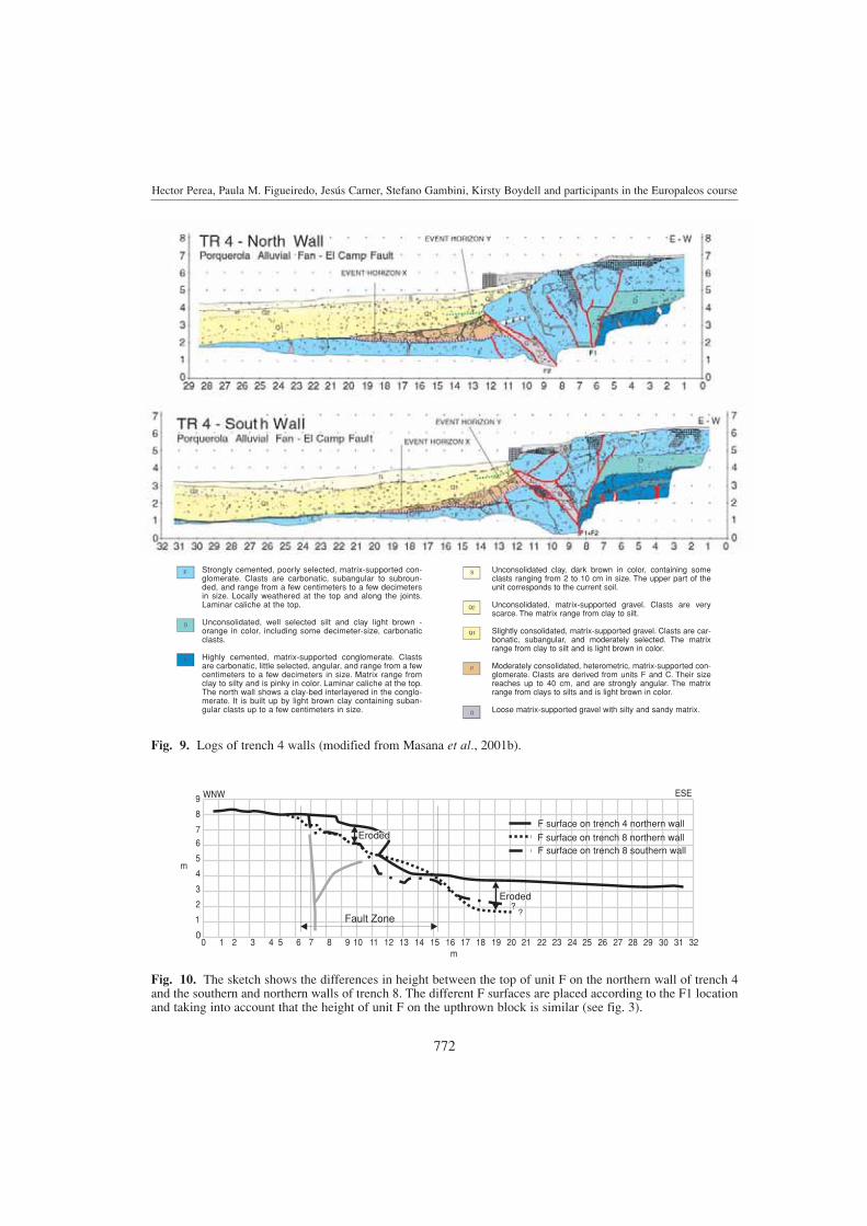
The accommodation space at trenches 4 and8 due to the fault movement should be verysimilar because of their proximity, resulting ina similar sedimentary thickness. Nevertheless,the sedimentary thickness at trench 8 is greaterthan at trench 4. Moreover, the top of unit F is
approximately 2 m deeper at trench 8 than attrench 4 (fig. 10). This modification of the ac-commodation space can be attributed to amarked erosion in the vicinity of trench 8 evi-denced by the small gully located to the northof it. The modification of the accommodationspace should be pointed out to avoid interpret-ing the sedimentary relationship between unitsF, G and H as another event.
Three seismic events have been described inrelation to the El Camp Fault in the last 125.000years (Masana, 1995, 1996; Masana et al., 2000,2001a,b; Santanach et al., 2001): a) event X hasa time bracket between 125.000 and 50.000 yearsBP and is the oldest; b) event Y is between 50.000and 35.000 years BP, and c) event Z occurredbetween 25.000 and 3000 years BP. At trench 8we also found 3 events, although some uncer-tainty exists for events 1 and 3. As stated above,the two oldest events at trench 8 (3 and 2)occurred in a time bracket between 125.000 and34.000 years BP, whereas event 1 is younger than13.500 years BP. Therefore, events 3 and 2 couldcorrespond to events X and Y, respectively, andevent 1 could correspond to event Z. Thus, trench 8could yield evidence of the last event, which hasnot been recorded at trench 4.
Although it was not possible to obtain thesingle displacements for events X, Y and Z attrench 8, they have been reported in earlier works(Masana et al., 2000, 2001a,b; Santanach et al.,2001): a) a displacement ranging between 1.4and 2.0 for event X, but the authors suggest thatthis displacement could correspond to the accu-
Paleoseismological data from a new trench across the El Camp Fault (Catalan Coastal Ranges, NE Iberian Peninsula)
Table I. Trench 8 dating results.
Sample 13C Fraction ± D14C ± 14C age ± Calibrated ±name modern age (*)
ERT8-2 .05 mgC – 25 0.2483 0.0076 – 751.7 7.6 11190 250 13153 BP 657ERT8-6 shell 0 0.0143 0.0005 – 985.7 0.5 34130 280
ERT8-8 – 25 1.2301 0.0078 230.1 7.8 > Modern(*) Stuiver and Reimer (1993). 13C values are the assumed values according to Stuiver and Polach (1977) whengiven without decimal places. Values measured for the material itself are given with a single decimal place. Thequoted age is in radiocarbon years using the Libby half life of 5568 years and following the conventions ofStuiver and Polach (1977). Radiocarbon concentration is given as fraction Modern, D14C, and conventionalradiocarbon age. Sample preparation backgrounds have been subtracted, based on measurements of samples of14C-free coal for ERT8-2 and ERT8-8, and of 14C-free calcite for ERT8-6. Backgrounds were scaled relative tosample size. Comments: the material dated was acid-alkali-acid treated charcoal. The large uncertainty forERT8-2 is due to the small sample size.
771
Hector Perea, Paula M. Figueiredo, Jesús Carner, Stefano Gambini, Kirsty Boydell and participants in the Europaleos course
0 1 2 3 4 5 6 7 8 9 10 11 12 13 14 15 16 17 18 19 20 21 22 23 24 25 26 27 28 29 30 31 320
1
2
3
4
5
67
8
9 WNW ESE
m
m
F surface on trench 4 northern wall
F surface on trench 8 southern wallF surface on trench 8 northern wall
Fault Zone?
?
Eroded
Eroded
Fig. 9. Logs of trench 4 walls (modified from Masana et al., 2001b).
Strongly cemented, poorly selected, matrix-supported con-glomerate. Clasts are carbonatic, subangular to subroun-ded, and range from a few centimeters to a few decimetersin size. Locally weathered at the top and along the joints.Laminar caliche at the top.
Unconsolidated, well selected silt and clay light brown -orange in color, including some decimeter-size, carbonaticclasts.
Highly cemented, matrix-supported conglomerate. Clastsare carbonatic, little selected, angular, and range from a fewcentimeters to a few decimeters in size. Matrix range fromclay to silty and is pinky in color. Laminar caliche at the top.The north wall shows a clay-bed interlayered in the conglo-merate. It is built up by light brown clay containing suban-gular clasts up to a few centimeters in size.
Unconsolidated clay, dark brown in color, containing someclasts ranging from 2 to 10 cm in size. The upper part of theunit corresponds to the current soil.
Unconsolidated, matrix-supported gravel. Clasts are veryscarce. The matrix range from clay to silt.
Slightly consolidated, matrix-supported gravel. Clasts are car-bonatic, subangular, and moderately selected. The matrixrange from clay to silt and is light brown in color.
Moderately consolidated, heterometric, matrix-supported con-glomerate. Clasts are derived from units F and C. Their sizereaches up to 40 cm, and are strongly angular. The matrixrange from clays to silts and is light brown in color.
Loose matrix-supported gravel with silty and sandy matrix.
Fig. 10. The sketch shows the differences in height between the top of unit F on the northern wall of trench 4and the southern and northern walls of trench 8. The different F surfaces are placed according to the F1 locationand taking into account that the height of unit F on the upthrown block is similar (see fig. 3).
772
mulation of two events; b) 0.4 m of displace-ment for event Y, and c) a displacement rangingbetween 0.7 and 1.0 m for event Z. These dis-placements could correspond to a maximumearthquake with an Mw ranging between 6.3 to6.8 and, consequently, a rupture surface lengthbetween 13 and 24 km (Wells and Coppersmith,1994), which is in agreement with the length ofthe El Camp Fault.
7. Conclusions
Two long topographic profiles made acrossthe El Camp Fault at the La Porquerola alluvialfan allowed us to establish an offset bracket forthe top of the G3 generation fan. This offsetbracket ranges between 6.7 and 10.5 m. Basedon these data, the vertical slip rate for the last125.000 years ranges between 0.05 and 0.08mm/yr and the dip slip between 0.06 and 0.09mm/yr. We consider the lower values to bemore realistic when these are compared withthe earlier studies.
The change in the scarp direction visible at the La Porquerola site is attributed to thechange in the fault direction, although the ero-sion evidenced by the adjacent gully influencedthe architecture of trench 8.
The stratigraphic and structural analyses ofthe different units at trench 8 constrain oneclear paleoseismic event and two less certainones. The datings obtained give an age for thetwo oldest paleoseismic events (3 and 2) rang-ing from 125.000 to 34.000 years BP and an ageyounger than 13.500 years BP for the last one(event 1). Events 1, 2 and 3 at trench 8 can becorrelated with events Z (3000-25.000 yearsBP), Y (35.000-50.000 years BP) and X (50.000-100.000 years BP) described in earlier studies.Event Z had not been described at the LaPorquerola site to date.
Acknowledgements
The data presented in this report are theresult of the Europaleos course (HPCF-CT-2000-00077). We wish to thank all those whoattended the Europaleos course and especially
Daniela Pantosti, Pere Santanach and EulaliaMasana for organising the course. The reviewsby A. Meigs and P. Villamor greatly helped toimprove the manuscript.
REFERENCES
BANDA, E. and P. SANTANACH (1992): The Valencia trough(Western Mediterranean): an overview, Tectono-physics, 208, 183-202.
DOGLIONI, C., E. GUEGUEN, F. SÀBAT and M. FERNÁNDEZ
(1997): Western Mediterranean extensional basins versus Alpine orogen, Terra Nova, 9 (3), 109-112.
DOGLIONI, C., E. GUEGUEN, F. SÀBAT and M. FERNÁNDEZ
(1999): On the interference between the early Apennines-Maghrebides backarc extension and the Alps-Betics orogen in the Neogene Geodynamics of the WesternMediterranean, Boll. Soc. Geol. It., 118, 75-89.
FONTBOTÉ, J.M., J. GUIMERÀ, E. ROCA, F. SÀBAT, P.SANTANACH and F. FERNÁNDEZ-ORTIGOSA (1990): TheCenozoic geodynamic evolution of the València trough(Western Mediterranean), Rev. Soc. Geol. España, 3(3/4), 249-259.
GUEGUEN, E., C. DOGLIONI and M. FERNÁNDEZ (1998): Onthe past 25 Ma geodynamic evolution of the WesternMediterranean, Tectonophysics, 298, 259-269.
MASANA, E. (1995): L’activitat neotectònica a les CadenesCostaneres Catalanes, Doctoral Thesis, Universitat deBarcelona, pp. 444.
MASANA, E. (1996): Evidence for past earthquakes in anarea of low historical seismicity: the Catalan CoastalRanges, NE Spain, Ann. Geofis., 39 (3), 689-704.
MASANA, E., J.A. VILLAMARÍN, J. SANCHEZ CABAÑERO, J.PLAZA and P. SANTANACH (2000): Seismological behav-iour of a fault with no historical seismicity: El CampFault (Northeastern Iberian Peninsula), in Evaluationof the Potential for Large Earthquakes in Regions ofPresent Day Low Seismic Activity in Europe, Workshop13-17 March 2000 Han-Sur-Lesse, Belgium, 101-104.
MASANA, E., J.A. VILLAMARÍN, J. SÁNCHEZ CABAÑERO, J.PLAZA and P. SANTANACH (2001a): A seismogenic faultin a low seismic area, Geol. Mijnbouw/Netherlands J.Geosc., 80 (3/4), 229-241.
MASANA, E., J.A. VILLAMARÍN and P. SANTANACH (2001b):Paleoseismic results from multiple trenching analysisalong a silent fault: the El Camp Fault (Tarragona,Northeastern Iberian Peninsula), Acta Geol. Hipánica,36 (3/4), 329-354.
MAUFFRET, A., J.P. FAIL, L. MONTADERT, J. SANCHO and E.WINNOCK (1973): Northwestern Mediterranean sedi-mentary basin from seismic reflection profile, Am.Assoc. Petrol. Geol. Bull., 57, 2245-2262.
MEDIALDEA, J., A. MALDONADO, B. ALONSO, J.L. DÍAZ, M.FARRÁN, S. GIRÓ, A. VÁZQUEZ, E. SAINZ-AMOR, A.MARTÍNEZ and T. MEDIALDEA (1986): Mapa Geológicode la Plataforma Continental Española y ZonasAdyacentes, Escala 1:200.000, Hoja 41/42 (Tortosa-Tarragona), mem. expl. (IGME, Madrid), pp. 78.
NUÑEZ, A., I. COLODRÓN, V. RUIZ, I. CABAÑAS, A. URALDE,F. ABELLÁN, R. BRETONES and S.A. FINA IBÉRICA
773
Paleoseismological data from a new trench across the El Camp Fault (Catalan Coastal Ranges, NE Iberian Peninsula)

(1980): Mapa Geológico de España, Escala 1:50.000,Hoja 472 (Reus) (IGME, Madrid), Primera edición,pp. 33.
ROCA, E. (1992): L’estructura de la Conca Catalano-Balear:paper de la compressió i de la distensió en la seva gè-nesi, Doctoral Thesis, Universitat de Barcelona,pp. 330.
ROCA, E. (1996): La evolución geodinámica de la CuencaCatalano-Balear y áreas adyacentes desde el Meso-zoico hasta la actualidad, Acta Geol. Hipánica, 29 (1),3-25.
ROCA, E. and J. GUIMERÀ (1992): The Neogene structure ofthe eastern Iberian margin: structural constrains on thecrustal evolution of the València trough (WesternMediterranean), Tectonophysics, 203, 203-218.
SÀBAT, F., E. ROCA, J.A. MUÑOZ, J. VERGÉS, P. SANTANACH,M. SANS, E. MASANA, A. ESTÉVEZ and C. SANTISTEBAN
(1997): Role of extension and compression in the evo-lution of the eastern margin of the Iberia: the ESCI-València trough seismic profile, Rev. Soc. Geol.España, 8 (4), 431-448.
SANTANACH, P., E. MASANA, J.A. VILLAMARÍN, J. SANCHEZ
CABAÑERO and J. PLAZA (2001): Proyecto Datación,Publicaciones CSN, pp. 159.
SANTANACH, P., E. MASANA and H. PEREA (2002): Structureof the Montroig scarp (El Camp Fault, NE IberianPeninsula): paleoseismological implications, in XXVIIIGeneral Assembly of the European SeismologicalCommission (ESC), 1-6 September 2002, Genoa, Italy,Book of Abstracts (University of Genoa), pp. 204.
STUIVER, M. and H. POLACH (1977): Discussion: reportingof C-14 data, Radiocarbon, 19 (3), 355-363.
STUIVER, M. and P.J. REIMER (1993): Extended (super 14) Cdata base and revised CALIB 3.0 (super 14) C age cal-ibration program, Radiocarbon, 35 (1), 215-230.
VILLAMARÍN, J.A., E. MASANA, T. CALDERÓN, R. JULIÀ
and P. SANTANACH (1999): Abanicos aluviales cua-ternarios del Baix Camp (provincia de Tarragona):resultados de dataciones radiométricas, Geogaceta,25, 211-214.
WELLS, D.L. and K.J. COPPERSMITH (1994): New empiricalrelationships among magnitude, rupture length, rupturewidth, rupture area, and surface displacement, Bull.Seismol. Soc. Am., 84, 1-24.
774
Hector Perea, Paula M. Figueiredo, Jesús Carner, Stefano Gambini, Kirsty Boydell and participants in the Europaleos course