paleogeographic maps of north america
TRANSCRIPT

Paleogeographic Maps of North AmericaAuthor(s): Bailey WillisSource: The Journal of Geology, Vol. 17, No. 7 (Oct. - Nov., 1909), pp. 600-602Published by: The University of Chicago PressStable URL: http://www.jstor.org/stable/30058573 .
Accessed: 14/05/2014 07:36
Your use of the JSTOR archive indicates your acceptance of the Terms & Conditions of Use, available at .http://www.jstor.org/page/info/about/policies/terms.jsp
.JSTOR is a not-for-profit service that helps scholars, researchers, and students discover, use, and build upon a wide range ofcontent in a trusted digital archive. We use information technology and tools to increase productivity and facilitate new formsof scholarship. For more information about JSTOR, please contact [email protected].
.
The University of Chicago Press is collaborating with JSTOR to digitize, preserve and extend access to TheJournal of Geology.
http://www.jstor.org
This content downloaded from 195.78.108.43 on Wed, 14 May 2014 07:36:49 AMAll use subject to JSTOR Terms and Conditions

PALEOGEOGRAPHIC MAPS OF NORTH AMERICA
BAILEY WILLIS U. S. Geological Survey
QUATERNARY NORTH AMERICA
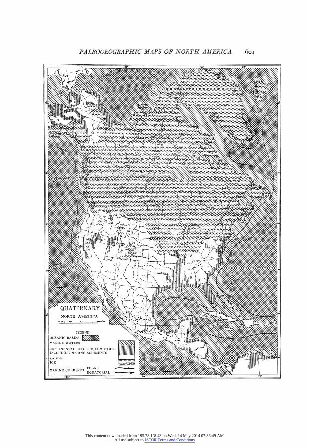
North America during the Quaternary presents very unusual features. The land area is large. The margin of the continental plateau is now somewhat submerged, but probably has not been so throughout the period. Marine embayments are not extensive, except Hudson Bay, which is a fair example of the smaller epi- continental seas that have spread over various parts of the continent in the past. Mountain systems that are great in extent and height have grown from the places of the early Tertiary ranges of the Cordil- lera, which had been deeply eroded before the Pliocene. The Appalachian Mountains, which began to rise above the plains of eastern America possibly as early as the Eocene and which toward the close of the Miocene had ceased to grow at something less than half their present greatest height, have been raised to their existing altitudes during the Quaternary.
These mountain features of North America are paralleled or exceeded in other continents and the period is thus characterized as one during which the forces that raise mountains have been decidedly active.
In late Tertiary time great differences of climate developed. The equatorial, temperate, and polar zones became much more unlike than they ever had been, according to the geologic record. The Quaternary is distinguished by the development, the advances, and retreats of several ice sheets, whose combined areas are shown on the map. The expanse of ice was at no one time so great, but the entire area shown as ice was covered at one time or another, and some parts of it several times successively, by continental glaciers.
I Published by permission of the Director of the U. S. Geological Survey.
600
This content downloaded from 195.78.108.43 on Wed, 14 May 2014 07:36:49 AMAll use subject to JSTOR Terms and Conditions
PALEOGEOGRAPHIC MAPS OF NORTH AMERICA
QUATERNARY NORTH AMERICA
LEGEND
OCEANIC BASINS
MARINE WATERS
CONTINENTAL DEPOSITS, SOMETIMES INCLUDING MARINE SEDIMENTS
LANDS ICE
POLAR MARINE CURRENTS
EQUATORIAL
60I
This content downloaded from 195.78.108.43 on Wed, 14 May 2014 07:36:49 AMAll use subject to JSTOR Terms and Conditions

602 BAILEY WILLIS
The developments of topography and climate, including polar refrigeration and corresponding modifications of oceanic conditions, have greatly changed the environment of plants and animals, and have resulted in special phenomena of competition and adaptation, through which existing forms have been evolved.
This content downloaded from 195.78.108.43 on Wed, 14 May 2014 07:36:49 AMAll use subject to JSTOR Terms and Conditions