paleoenvironments of early devonian plants and fish in the … · 2012. 2. 20. · psilophyton...
TRANSCRIPT
Outstanding StudentPosterContest
Thisposterparticipatesin
OSP
est. 2002
Paleoenvironments of Early Devonian plants and fish in the Campbellton Formation, New Brunswick, Canada: invasion of the land at a classic locality
Paleoenvironments of Early Devonian plants and fish in the Campbellton Formation, New Brunswick, Canada: invasion of the land at a classic locality
Paleoenvironments of Early Devonian plants and fish in the Campbellton Formation, New Brunswick, Canada: invasion of the land at a classic locality
Fig. 1 - Lochkovian-Pragian geologic setting
Val d’Amour Volcanics
Avalonia microcontinent
Laurentian margin
N
E
S
W
Foreland basin
Fig. 2 - Emsian-Eifellian geologic setting
N
E
S
W
Gaspe Sandstones Group
Foreland basin
Intermontane basins
Key for stratigraphic columns:
trough cross stratification
ripple cross stratification
grading
planar laminationsplane bedding
dune foresets
imbrication
siderite nodules
nodules and concretions
mottled colouringmicrobialitesrootsbioturbation
Structures
Lithologymudstone
siltstone
shale
sandstone
conglomerate
matrix-supported conglomerate
clast-supported conglomerate
dike or sill
missing
Section VI
6
930
920
910
Scal
e (m
)
Lith
olo
gy MUDSAND
GRAVEL
clay
silt
fm
cvcvf
gran
peb
bco
bb
bo
ul
StructuresEnvi
ron
men
t
Section III
Section IV
Section V
30
20
10
66
70
90
100
5
Scal
e (m
)
Lith
olo
gy MUDSAND
GRAVEL
clay
silt
fmcvcvf
gran
peb
bco
bb
bo
ul
StructuresEnvi
ron
men
t
Section II
70
60
56
30
20
10
80
5
2
MUDSAND
GRAVEL
clay
silt
fm
cvc
Scal
e (m
)
Lith
olo
gy
StructuresEnvi
ron
men
t
vf
gran
peb
bco
bb
bo
ul
Section I
Eastern BeltWestern Belt
-70° -66° -62°
46°
50°
0 50 100km
-66°24'-66°44' -66°40' -66°36' -66°32'
48°00'
48°04'
-66°28'
Restigouche RiverQUEBEC
NEW BRUNSWICK
Campbellton
Dalhousie Junction
OutcropCityPaleocurrentsStratigraphic sections
Bonaventure FmCampbellton FmLa Garde FmVal d’Amour FmIndian Point Fm
Legend:
N 1 km
IV
VIIII
V
n=4
n=2
n=14
n=3
I
I
IIn=6
n=5
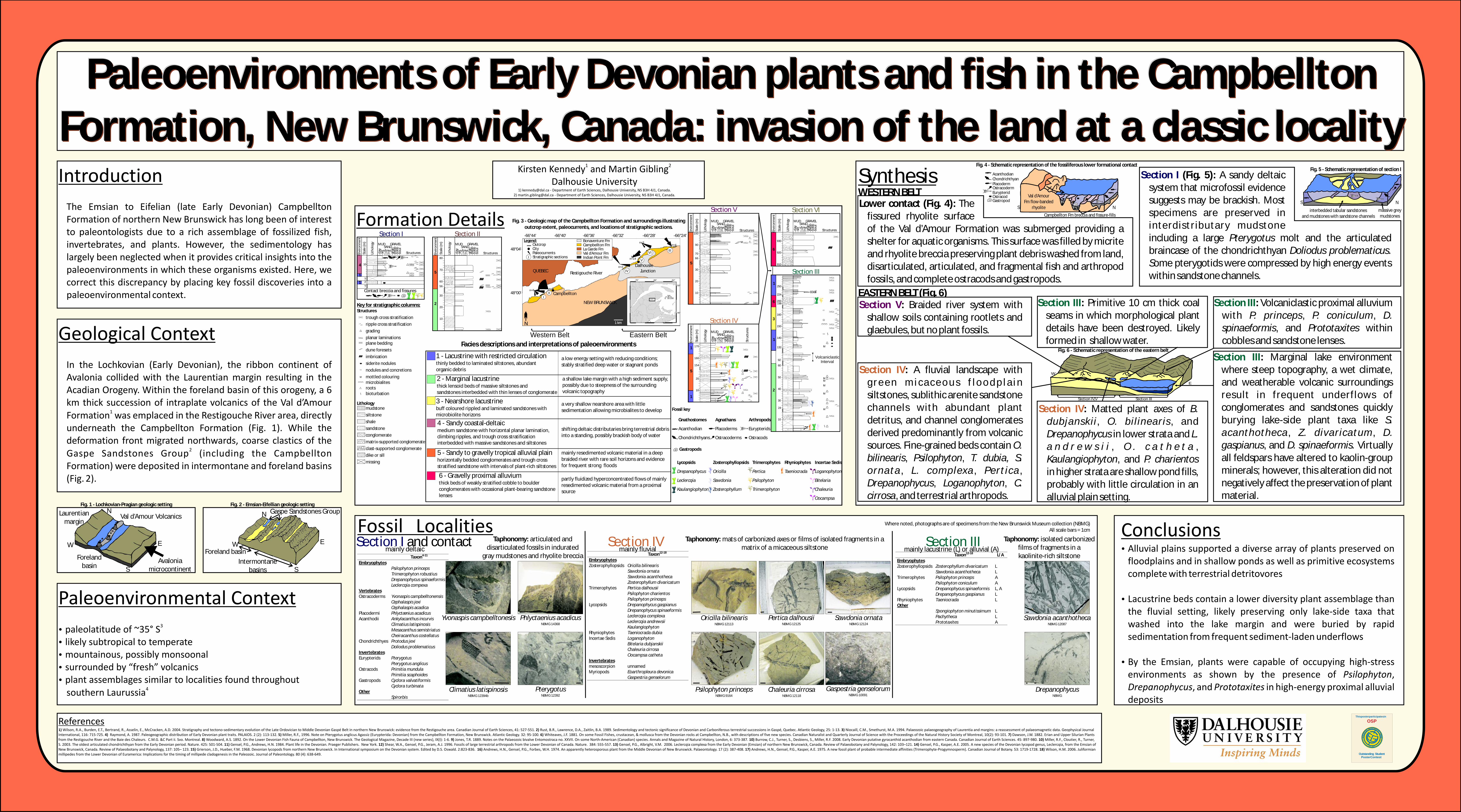
Facies descriptions and interpretations of paleoenvironments
Fig. 3 - Geologic map of the Campbellton Formation and surroundings illustrating outcrop extent, paleocurrents, and locations of stratigraphic sections.
a low energy setting with reducing conditions; stably stratified deep water or stagnant ponds
1 - Lacustrine with restricted circulationthinly bedded to laminated siltstones, abundantorganic debris
a shallow lake margin with a high sediment supply,possibly due to steepness of the surrounding volcanic topography
2 - Marginal lacustrinethick lensoid beds of massive siltstones and sandstones interbedded with thin lenses of conglomerate
a very shallow nearshore area with little sedimentation allowing microbialites to develop
3 - Nearshore lacustrinebuff coloured rippled and laminated sandstones withmicrobiolite horizons
shifting deltaic distributaries bring terrestrial debris into a standing, possibly brackish body of water
4 - Sandy coastal-deltaicmedium sandstone with horizontal planar lamination, climbing ripples, and trough cross stratification interbedded with massive sandstones and siltstones
mainly resedimented volcanic material in a deep braided river with rare soil horizons and evidence for frequent strong floods
5 - Sandy to gravelly tropical alluvial plainhorizontally bedded conglomerates and trough cross stratified sandstone with intervals of plant-rich siltstones
partly fluidized hyperconcentrated flows of mainly resedimented volcanic material from a proximal source
6 - Gravelly proximal alluviumthick beds of weakly stratified cobble to boulder conglomerates with occasional plant-bearing sandstone lenses
170
160
154
20
10
1
5
1
Scal
e (m
)
Lith
olo
gy
clay
silt
f c gran
peb
bco
bb
bo
ul
Stru
ctu
res
Envi
ron
men
t
MUDSAND
GRAVEL
mvcvf
Trimerophytes
Pertica
Psilophyton
Trimerophyton
Incertae Sedis
Loganophyton
Bitelaria
Chaleuria
Oocampsa
Rhyniophytes
Taeniocrada
Fossil key
Arthropods
Eurypterids
Ostracods
Gnathostomes
Acanthodian
Chondrichthyans
Agnathans
Placoderms
Ostracoderms
Gastropods
Lycopsids
Drepanophycus
Leclercqia
Kaulangiophyton
Zosterophyllopsids
Oricilla
Sawdonia
Zosterophyllum
10
2?
?1
1
4
Scal
e (m
)
Lith
olo
gy MUDSAND
GRAVEL
clay
silt
fm
cvcvf
gran
peb
bco
bb
bo
ul
StructuresEnvi
ron
men
t
Contact breccia and fissures
SynthesisWESTERN BELT
EASTERN BELT (Fig. 6)
AcanthodianChondrichthyanPlacodermOstracodermEurypteridOstracodGastropod
Campbellton Fm breccia and fissure-fills
Fig. 4 - Schematic representation of the fossiliferous lower formational contact
Val d’Amour Fm flow-banded
rhyolite NSinterbedded tabular sandstones
and mudstones with sandstone channels massive grey mudstones
Fig. 5 - Schematic representation of section I
NS
Section V: Braided river system with shallow soils containing rootlets and glaebules, but no plant fossils.
Section IV: A fluvial landscape with g r e e n m i c a c e o u s f l o o d p l a i n siltstones, sublithic arenite sandstone channels with abundant plant detritus, and channel conglomerates derived predominantly from volcanic sources. Fine-grained beds contain O. bilinearis, Psilophyton, T. dubia, S. ornata , L. complexa , Pertica , Drepanophycus, Loganophyton, C. cirrosa, and terrestrial arthropods.
Section IV: Matted plant axes of B. dubjanskii , O. bilinearis , and Drepanophycus in lower strata and L. a n d r e w s i i , O . c a t h e t a , Kaulangiophyton, and P. charientos in higher strata are shallow pond fills, probably with little circulation in an alluvial plain setting.
Section III: Marginal lake environment where steep topography, a wet climate, and weatherable volcanic surroundings result in frequent underflows of conglomerates and sandstones quickly burying lake-side plant taxa like S. acanthotheca , Z. divaricatum , D. gaspianus, and D. spinaeformis. Virtually all feldspars have altered to kaolin-group minerals; however, this alteration did not negatively affect the preservation of plant material.
Section III: Pseams in which morphological plant details have been destroyed. Likely formed in shallow water.
rimitive 10 cm thick coal Section III: Volcaniclastic proximal alluvium with P. princeps, P. coniculum, D. spinaeformis, and Prototaxites within cobbles and sandstone lenses.
Lower contact (Fig. 4): The fissured rhyolite surface of the Val d’Amour Formation was submerged providing a shelter for aquatic organisms. This surface was filled by micrite and rhyolite breccia preserving plant debris washed from land, disarticulated, articulated, and fragmental fish and arthropod fossils, and complete ostracods and gastropods.
Section I (Fig. 5): A sandy deltaic system that microfossil evidence suggests may be brackish. Most specimens are preserved in interdistributary mudstone including a large Pterygotus molt and the articulated braincase of the chondrichthyan Doliodus problematicus. Some pterygotids were compressed by high energy events within sandstone channels.
Section IV,V
E
W
Section III
Fig. 6 - Schematic representation of the eastern belt
Taxon4-11
Embryophytes Psilophyton princeps Trimerophyton robustius Drepanophycus spinaeformis Leclercqia compexa Vertebrates Ostracoderms Yvonaspis campbelltonensis Cephalaspis jexi Cephalaspis acadica Placodermi Phlyctænius acadicus Acanthodii Ankylacanthus incurvis Climatius latispinosis Mesacanthus semistriatus Cheiracanthus costellatus Chondrichthyes Protodus jexi Doliodus problematicus Invertebrates Eurypterids Pterygotus Pterygotus anglicus Ostracods Primitia mundula Primitia scaphoides Gastropods Cyclora valvatiformis Cyclora turbinata Other Spirorbis
Section I and contact
mainly deltaicSection III
mainly lacustrine (L) or alluvial (A) Taxon12-18 L/A
Embryophytes Zosterophyllopsids Zosterophyllum divaricatum L Sawdonia acanthotheca L Trimerophytes Psilophyton princeps A Psilophyton coniculum A Lycopsids Drepanophycus spinaeformis L, A Drepanophycus gaspianus L Rhyniophytes Taeniocrada L Other Spongiophyton minutissimum L Pachytheca L Prototaxites A
Gaspestria genselorumNBMG 10091
Sawdonia acanthotheca NBMG 12087
DrepanophycusNBMG
Sawdonia ornataNBMG 12124
Taphonomy: mats of carbonized axes or films of isolated fragments in a matrix of a micaceous siltstone
Taphonomy: isolated carbonized films of fragments in a kaolinite-rich siltstone
Where noted, photographs are of specimens from the New Brunswick Museum collection (NBMG)All scale bars = 1cm
Section IVmainly fluvial
Taxon12-18
Embryophytes Zosterophyllopsids Oricilla bilinearis Sawdonia ornata Sawdonia acanthotheca Zosterophyllum divaricatum Trimerophytes Pertica dalhousii Psilophyton charientos Psilophyton princeps Lycopsids Drepanophycus gaspianus Drepanophycus spinaeformis Leclercqia complexa Leclercqia andrewsii Kaulangiophyton Rhyniophytes Taeniocrada dubia Incertae Sedis Loganophyton Bitelaria dubjanskii Chaleuria cirrosa Oocampsa catheta Invertebrates mesoscorpion unnamed Myriopods Eoarthropleura devonica Gaspestria genselorum
PterygotusNBMG 12392
Phlyctaenius acadicusNBMG 14368
Oricilla bilinearisNBMG 12113
Psilophyton princepsNBMG 9164
Climatius latispinosisNBMG 12394b
Yvonaspis campbelltonesis Pertica dalhousiiNBMG 12125
Chaleuria cirrosaNBMG 12118
Taphonomy: articulated and disarticulated fossils in indurated
gray mudstones and rhyolite breccia
1
250
224
200198
160
150
140
132
92
60
50
40
30
24
10
Volcaniclastic Interval
6
3
2
1
coal