pacific northwest coast landscape...
TRANSCRIPT
PACIFIC NORTHWEST COAST LANDSCAPE CONSERVATION DESIGN A LANDSCAPE CONSERVATION DESIGN FOR THE LOWER COLUMBIA
RIVER AND OUTER COASTS OF OREGON AND WASHINGTON
June 15, 2016
PACIFIC NORTHWEST COAST LANDSCAPE CONSERVATION DESIGN 2
TABLE OF CONTENTS
A. Statement of Need ............................................................................................................................. 3
B. Geographic Scope ............................................................................................................................... 4
C. Project Vision and Goals ..................................................................................................................... 6
D. Project Approach, Outcomes, and Deliverables .................................................................................. 6
E. Anticipated Benefits ......................................................................................................................... 18
F. Letters of Support ............................................................................................................................. 18
Appendix A. .......................................................................................................................................... 19
Appendix B. .......................................................................................................................................... 21
Appendix C. .......................................................................................................................................... 22
PACIFIC NORTHWEST COAST LANDSCAPE CONSERVATION DESIGN 3
A. Statement of Need The Pacific Northwest coast, including the Lower Columbia River and adjacent coasts of Oregon and Washington, contains a rich diversity of natural and cultural resources and is home to communities that value, use, and depend on these resources. However, stressors, including climate change, energy development, changes in land and water use practices, and a growing human population that is estimated to increase from 3.6 million people to 5.6 million people by 2050, challenge the long-term viability of these resources across the landscape. A broad spectrum of stakeholders—tribal sovereign nations; federal, state, and local government agencies; non-government organizations and academia; private sector interests; and the general public—have a keen interest in conserving, enhancing, and restoring these resources, in addition to maintaining working lands. Yet the complexities of the threats to ecological sustainability and human well-being, as well as the mix of management jurisdictions, belie the idea that any single organization or program, however well managed and funded, can singlehandedly maintain or improve large-scale ecological functions and values while meeting societal needs. A structured collaborative effort—referred to here as Landscape Conservation Design (LCD)—is needed to identify valued resources and ecosystem services, consider the impacts of individual and cumulative stressors, and focus and align efforts towards achieving shared landscape-scale goals and objectives.
There is a need to understand how local or regional management decisions made by these various entities fit into a larger landscape-scale context of conservation goals. Conversely, there is a need to assess the impacts of landscape-scale or systems-level factors and stressors on management-relevant issues at smaller spatial scales and under different future scenarios. For example, there is a need to understand how changes in sea level, ocean acidification, population growth, and land use affect issues such as habitat distribution, loss and connectivity, species distribution, and ecosystem health. Additionally, there is a need to integrate this information across ecosystem types, incorporating interactions between terrestrial, riverine, and estuarine systems.
Finally, it is important to organize an effective infrastructure that honors existing studies, plans, science, and implementation efforts already underway yet also encourages stakeholders to work together on a common agenda, strategic action framework, and measures of success. The overarching need is to create a landscape conservation blueprint that can help individual partners, from local governments and community groups to statewide and regional land management agencies, identify opportunities and implement actions that fulfill their needs while also, through coordination and a mutually reinforcing plan of action, support priorities shared by a larger group of stakeholders. This initiative is focused on developing the trust, relationships, flexibility, processes, capacity, information, and tools required to create a foundation for collective impact and lasting landscape-scale conservation.
PACIFIC NORTHWEST COAST LANDSCAPE CONSERVATION DESIGN 4
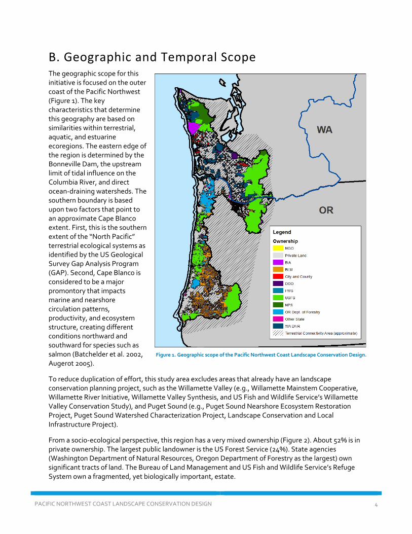
B. Geographic and Temporal Scope The geographic scope for this initiative is focused on the outer coast of the Pacific Northwest (Figure 1). The key characteristics that determine this geography are based on similarities within terrestrial, aquatic, and estuarine ecoregions. The eastern edge of the region is determined by the Bonneville Dam, the upstream limit of tidal influence on the Columbia River, and direct ocean-draining watersheds. The southern boundary is based upon two factors that point to an approximate Cape Blanco extent. First, this is the southern extent of the “North Pacific” terrestrial ecological systems as identified by the US Geological Survey Gap Analysis Program (GAP). Second, Cape Blanco is considered to be a major promontory that impacts marine and nearshore circulation patterns, productivity, and ecosystem structure, creating different conditions northward and southward for species such as salmon (Batchelder et al. 2002, Augerot 2005).
To reduce duplication of effort, this study area excludes areas that already have an landscape conservation planning project, such as the Willamette Valley (e.g., Willamette Mainstem Cooperative, Willamette River Initiative, Willamette Valley Synthesis, and US Fish and Wildlife Service’s Willamette Valley Conservation Study), and Puget Sound (e.g., Puget Sound Nearshore Ecosystem Restoration Project, Puget Sound Watershed Characterization Project, Landscape Conservation and Local Infrastructure Project).
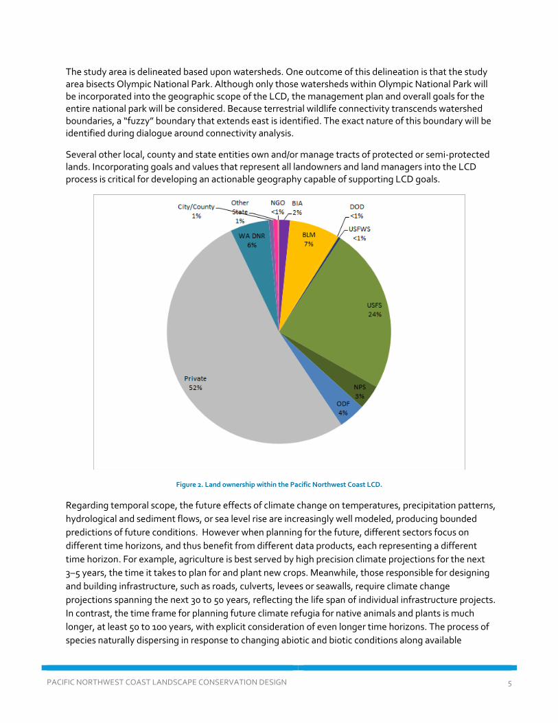
From a socio-ecological perspective, this region has a very mixed ownership (Figure 2). About 52% is in private ownership. The largest public landowner is the US Forest Service (24%). State agencies (Washington Department of Natural Resources, Oregon Department of Forestry as the largest) own significant tracts of land. The Bureau of Land Management and US Fish and Wildlife Service’s Refuge System own a fragmented, yet biologically important, estate.
Figure 1. Geographic scope of the Pacific Northwest Coast Landscape Conservation Design.
PACIFIC NORTHWEST COAST LANDSCAPE CONSERVATION DESIGN 5
The study area is delineated based upon watersheds. One outcome of this delineation is that the study area bisects Olympic National Park. Although only those watersheds within Olympic National Park will be incorporated into the geographic scope of the LCD, the management plan and overall goals for the entire national park will be considered. Because terrestrial wildlife connectivity transcends watershed boundaries, a “fuzzy” boundary that extends east is identified. The exact nature of this boundary will be identified during dialogue around connectivity analysis.
Several other local, county and state entities own and/or manage tracts of protected or semi-protected lands. Incorporating goals and values that represent all landowners and land managers into the LCD process is critical for developing an actionable geography capable of supporting LCD goals.
Figure 2. Land ownership within the Pacific Northwest Coast LCD.
Regarding temporal scope, the future effects of climate change on temperatures, precipitation patterns, hydrological and sediment flows, or sea level rise are increasingly well modeled, producing bounded predictions of future conditions. However when planning for the future, different sectors focus on different time horizons, and thus benefit from different data products, each representing a different time horizon. For example, agriculture is best served by high precision climate projections for the next 3–5 years, the time it takes to plan for and plant new crops. Meanwhile, those responsible for designing and building infrastructure, such as roads, culverts, levees or seawalls, require climate change projections spanning the next 30 to 50 years, reflecting the life span of individual infrastructure projects. In contrast, the time frame for planning future climate refugia for native animals and plants is much longer, at least 50 to 100 years, with explicit consideration of even longer time horizons. The process of species naturally dispersing in response to changing abiotic and biotic conditions along available
PACIFIC NORTHWEST COAST LANDSCAPE CONSERVATION DESIGN 6
corridors to available refugia does not have an identifiable temporal end point. However the capacity of wildlife and land managers to plan for the future is limited to identifiable and justifiable timelines. In developing decision support products, this project will keep attempt to match the products with the temporal time frame of decision needs.
C. Project Vision and Goals Vision: Achieve a network of healthy, connected, ecosystems and working landscapes capable of providing a full suite of ecosystem services that can absorb, respond, and adapt to climatic change and other key stressors through the use of collaborative, science-based strategies.
Goals:
1) To foster a spirit of collaboration, communication, and continual learning among the communities and diverse interests within the study area.
2) To understand how climate change and other stressors will affect the region. 3) To identify a diverse suite of intact, connected, functioning ecosystems and working landscapes
capable of adapting to stressors and providing important ecological functions and services. 4) To create science-based, spatially explicit products that identifies priority areas and the
conservation actions necessary to achieve specified conservation goals and targets. 5) To sustain healthy habitats for native fish, wildlife, and plant species and a suite of ecosystem
services that benefit people.
D. Project Approach, Outcomes, and Deliverables The approach for this project is based on input from three in-person LCD core team meetings, two surveys, common elements from a suite of Landscape Conservation Cooperative (LCC)-driven LCD projects, as well as concepts from the literature. More than 100 individuals representing 67 federal, state and local governments, tribal sovereign nations, and industry expressed interest in participating in the LCD (Appendix A). During the in-person core team workshops, participating organizations articulated their goals in engaging in a collaborative landscape design. A list summarizing common themes was developed (Appendix B). This list was then prioritized using a web-based survey (Appendix C). This partner engagement process provided the framework for developing this project plan.
By reviewing other LCD projects (e.g., South Atlantic Blueprint, Columbia Plateau, Connecticut River), we can learn from other LCD processes and products that have been developed. Foundational literature in landscape ecology, conservation planning, and climate adaptation provide further reinforcement of our thinking.
A key aspect of the technical approach is prototyping—building a holistic model and understanding of conservation in the region necessitates that we experience a development progression. The general theory is that we will understand more about the entire system through prototyping than by requiring precision at every stage. Through iterative prototyping, successive versions of products will be developed, with each new version delving into greater specificity, incorporating the latest science and communal understanding.
PACIFIC NORTHWEST COAST LANDSCAPE CONSERVATION DESIGN 7
We are using the Integrated Convening, Assessment, Spatial Design, and Strategy Design (iCASS) framework (Campellone et al., to be submitted for journal review, June 2016)1 as the core framework for this LCD. The technical approach is guided by the following four core elements and associated high level characteristics and principles:
• Element 1: Convene Stakeholders and Coordinate the Project o Diverse social networks identify a shared vision for the landscape. o Inclusive processes advance social learning, and build trust and strong social networks
that express societal choices, share resources, and co-produce knowledge. • Element 2: Assess Current and Plausible Future Conditions
o Multidisciplinary research teams advance social learning about the landscape. o Interdisciplinary assessment of social-ecological systems model risks and
vulnerabilities, and suggest opportunities to trend toward desired future conditions. • Element 3: Develop Spatial Design
o Stakeholders design landscape configurations that promote resilience and sustainability during change and uncertainty.
o Interactive modeling and mapping techniques are used to develop a portfolio of spatial designs.
• Element 4: Design a Strategic Plan of Action o Decision makers identify strategies that promote resilience and sustainability for
current and future generations. o Informed decision-making navigates development of a strategic plan and related
stakeholder agreements.
Each element will have a series of objectives that relate to user needs and common LCD products. Each objective has a series of tasks and associated products.
Element 1: Convene Stakeholders and Coordinate the Project
Goal: Convene and maintain a broad base of partners throughout the project.
For this collaborative effort to withstand the challenges of convening and aligning many different organizations and interests, a strong foundational structure operating within a streamlined efficient process needs to be established to provide overall strategic direction, facilitate dialogue among partners, manage data collection and analysis, coordinate outreach, and mobilize funding. Core values for the partnership include recognizing strengths, honoring differences and constraints, and promoting both collaboration and inclusion of different perspectives. Through funding and leadership provided by the North Pacific LCC, a group of stakeholders convened in early 2016 to initiate the LCD process. A diversity of perspectives and interests were represented, including federal, state, and local agencies; tribal sovereign nations; non-governmental organizations; members of industry; landowners; community groups; citizens; and other entities. The core team was comprised of a subset of stakeholders form the initial governance structure for this effort (Appendix A).
1 This is a paper being developed by USFWS, BLM, Park Service, State and NGO authors to identify core principles of Landscape Conservation Design.
PACIFIC NORTHWEST COAST LANDSCAPE CONSERVATION DESIGN 8
During the first phase of this project, the core team identified broad shared goals and objectives. In next stages, we propose to use the Open Standards for Conservation as a framework for stepping this down to more tactile targets and objectives that will drive the landscape assessment and design. This will be a highly collaborative process that will further refine the key elements of the analytical approach.
Objective 1.1: Build and maintain core team and technical teams and communicate with stakeholders regarding the LCD processes, outcomes, and next steps.
Tasks:
● Fund and hire a coordinator/facilitator to help manage the overall LCD process. ● Hold regular bi-monthly Core Team meetings to track progress, guide the
process, and communicate emerging needs and interests. ● Develop a social network map (Mills et al. 2014) that assesses the relationships
between key natural resource interests in the region. The purpose of this map is to identify “nodes” and find ways to connect them into the project.
● Organize a “State of the Pacific Northwest Coast” symposium, a 1 to 2-day event, mid-way through the project that convenes stakeholders throughout the ecoregion.
● Develop a communications plan and materials for partner engagement (e.g., information on how organizations, private sector interests, and others can use the blueprint) and to ensure relevance. Strategies could include presentations at conferences and other appropriate venues, meetings with agencies, organizations, etc.
● Develop and maintain a web-based resource for stakeholders to communicate, identify project opportunities to meet shared priorities, and share information.
Objective 1.2: Identify shared goals and objectives for a suite of conservation and human well-being targets.
Tasks:
● A coarse-filter/fine-filter approach will be used to identify planning targets. Using techniques identified in the Open Standards for Conservation (Conservation Measures Partnership, 2013), identify 8–10 coarse-filter conservation “targets” that represent what we seek to protect, restore, adapt or maintain. Ecological communities or systems could be selected as conservation coarse-filter targets (Noss and Cooperrider 1994, Poiani et al. 2000), followed by fine-filter targets that include species with unique ecological requisites, not already captured by the conservation of those communities, or ecological systems in which they are embedded.
● Identify a set of human well-being targets (Collomb et al. 2012) (e.g., recreation, access to ecosystem services).
● Identify measureable objectives for each target, including timeframes. Start the process by mining existing plans and sources; continue to refine under Objective 2.1.
PACIFIC NORTHWEST COAST LANDSCAPE CONSERVATION DESIGN 9
Products/Deliverables for Element 1:
● Continued evolution of this project plan, including timeframes and budgets (Objective 1.1, Objective 4.4).
● Maintain meeting notes and communications via our website (Objective. 1.1). ● Social network analysis and map (Objective 1.1). ● Proceedings from “State of the Pacific Northwest Coast” symposium (Objective 1.1). ● Develop a collaborative communications plan for outreach (Objective 1.1). ● Produced a report that documents shared conservation and human well-being targets, goals,
and objectives (Objective 1.2). ● Select and describe conservation and human well-being targets as well as measurable
objectives documented using Open Standards/Miradi software (Objective 1.2). Element 2: Assessment of Current and Plausible Future Conditions
Goal: Assess the current and future condition of shared conservation targets.
This element builds upon the previous element by performing a spatial assessment of the current condition of the conservation and human well-being targets that were identified. Current condition of targets will be determined by using best available existing spatial data sets. For prototype Version 1.0, we will not produce new data sets of condition but rather synthesize existing data sets, or augment existing efforts, to map condition. Data collected and produced through Element 2 will play a role in the next element—Spatial Design.
Objective 2.1: Identify and map the extent and condition of conservation targets (see Element 1) throughout the region to build baseline conditions. Building from the 8–10 broad conservation targets, we will develop spatially explicit maps of the baseline extent and condition of the targets by identifying a limited set of “Key Ecological Attributes”, or KEAs. KEAs are indicators for the health of a system. For Version 1.0, it will be essential that our KEAs are readily mappable, or can be made mappable within a realistic period of time. A similar process was completed in the Columbia Plateau, and is currently underway in the NW Basin and Range. A process will be used to determine how to address non-mappable KEAs (i.e., those that have ecological attributes that are not readily mappable).
Tasks:
● Working with experts in the region, identify a limited number of mappable KEAs for each target.
● Develop analytical methods for assessing conditions for each target. ● Compile existing data. ● Develop maps and databases of conservation targets and make available online
(see Objective 3.5).
Objective 2.2: Identify and map human well-being targets (HWB) throughout the region. Ecosystem services analysis was identified as a “save for version 2.0” item in our poll by many, but identified as a high priority for some. We will investigate methods, approaches and existing data in version 1.0. In our Prototype version 1.0, we will use best available data to approximate the spatial extent of HWB targets. If identified as a higher priority, and if funding is available, we will develop new data to represent HWB targets. This may include ecosystem services mapping (for example, see existing data for this region Brandt et al. 2014), community values
PACIFIC NORTHWEST COAST LANDSCAPE CONSERVATION DESIGN 10
mapping (Alessa et al. 2008; Raymond et al. 2009), or other approaches that address identified HWB targets.
Tasks:
• Convene a sub-team of experts in human dimensions of landscape conservation to identify high-value needs and a long-term approach for addressing HWB targets.
• Assess the utility of existing data for addressing HWB targets. • Develop a work plan and proposal for a robust implementation of HWB targets
in version 2.0.
Objective 2.3: Identify and map future threats across the landscape, with an emphasis on climate change. Working with the Core Team and experts in the region, we will develop a threats assessment using the Open Standards as a framework. For each target, major threats will be identified. The threats will be compiled and mapped. For most threats in the region, there are spatially explicit databases that exist. For this project, we will pay special attention to sea level rise, altered hydrology caused by climate change, ocean acidification effects on estuary and nearshore environments, and changes to terrestrial vegetation and their habitats. We will use existing data, or augment existing efforts. For example, the US Forest Service is developing a spatial analysis of climate impacts to streams and priority salmonid habitat across the region; however it is not complete for the entire geographic scope of our LCD.
Tasks:
● Work with experts and the core team to identify threats and change agents for each of the targets.
● Synthesize and compile data and develop a spatial threats index from multiple sources (e.g., climate change, development, invasive species).
● Augment US Forest Service analyses for hydrological shifts to streams. The USFS is developing analyses of the vulnerability and resiliency of streams to climate change in watersheds managed by the USFS (G. Reeves, personal communication).
● Present findings of threats assessment to the broader community through webinars and workshops.
Products/Deliverables for Element 2:
● A spatially explicit database that represents the condition of targets across the region (Objective 2.1).
● An integrated condition index for our conservation targets (Objective2.1). ● An assessment of critical data gaps and data problems that limit the ability to assess condition. ● An assessment of human well-being targets and work plan and proposal for a robust
assessment (Objective 2.2). ● A prioritization of data gaps and how to fund (Objectives 2.1 and 2.3). ● A synthesis of future climate threats for all conservation targets (Objective 2.3). ● A synthesis of future non-climatic threats for all conservation targets (Objective 2.3). ● A process to manage data and associated metadata (Objective 2.3).
PACIFIC NORTHWEST COAST LANDSCAPE CONSERVATION DESIGN 11
Element 3: Development of a Spatial Design
Goal: Develop a conservation “blueprint” that represents an efficient, resilient, and representative network of priority places and connectivity zones to meet shared goals.
Objective 3.1: Identify priority core areas. The identification of places on the landscape that are irreplaceable to meet conservation goals is a fundamental landscape conservation planning task. There are existing prioritizations in the region, which either are due for revision (Vander Schaaf et al. 2006), cover a particular jurisdiction (Oregon Conservation Strategy 2016), or are for particular species or groups of species (Important Bird Areas, Salmon Strongholds).
Objective 3.1.1: Synthesize existing priority areas.
Tasks:
● Review existing relevant plans and studies to develop a spatial database of previously identified priority areas (e.g., Oregon Department of Fish and Wildlife (ODFW) conservation opportunity areas, The Nature Conservancy (TNC) portfolio sites, etc.).
Objective 3.1.2: Identify priority areas for terrestrial targets.
Tasks:
● Work with experts in the region to determine appropriate scale, resolution, and methodology (e.g., Marxan; see http://www.uq.edu.au/marxan/) for prioritizing areas for terrestrial-based conservation targets.
● Synthesize and compile data for terrestrial targets. Evaluate use of TNC resilient sites/land facets data to design for terrestrial system representation (Buttrick et al. 2015).
● Develop a collaborative process and tool to work through iterations. Host a workshop and series of meetings to review draft results.
● Refine and finalize.
Objective 3.1.3: Identify priority areas for freshwater targets.
Tasks:
● Work with experts in the region to determine appropriate scale, resolution (e.g., HUC 12 or 14), and methodology (e.g., Marxan) for prioritizing areas for freshwater conservation targets.
● Synthesize and compile data for freshwater targets. ● Develop a collaborative process and tool to work through iterations.
Host a workshop and series of meetings to review draft results. ● Refine and finalize.
PACIFIC NORTHWEST COAST LANDSCAPE CONSERVATION DESIGN 12
Objective 3.1.4: Identify priority areas for estuarine targets. We propose to use the work that will be completed by the Pacific Marine and Estuarine Fish Habitat Partnership (PMEP)2.
Tasks:
● Coordinate with PMEP to incorporate their prioritization framework.
Objective 3.1.5: Identify priority areas that meet goals across systems. Based upon integrated land-sea-freshwater planning literature (Adams et al. 2013; Alvarez-Romero et al. 2011), we will develop an approach that integrates priorities across terrestrial, freshwater, and estuarine targets. This process will be built from the analysis of individual systems by further investigating zones of influence and common threats across systems. The literature suggests that it is possible to use existing conservation planning tools, such as Marxan to address co-benefits across different system types (Adams et al. 2013). (Note that since this did not rank high in priorities for Version 1.0, this will be a lower initial priority, but we will initiate the process).
Tasks:
● Convene a group of scientists and conservation planners to identify an approach to integrated land-river-estuary conservation planning.
● Implement a draft spatial prioritization methodology across systems.
Objective 3.2: Map connectivity zones Mapping connectivity is an essential component of spatial design and connects priority core areas. Connectivity conservation is not only an important strategy for problems associated with habitat fragmentation, but it is also a well-accepted strategy for climate adaptation (Heller and Zavaleta 2009). The general approach is inspired by Krosby et al. (2015) findings that a combination of models based upon landscape integrity and a suite of focal species will address several connectivity planning questions. Before articulating the full approach, we will first convene a workshop of connectivity experts in the region to identify a limited suite of focal species to model and understand past and existing connectivity work in the region.
Tasks:
● Convene a one-day workshop to share knowledge about past and existing connectivity work in the region, identify a limited suite of focal species throughout the region, and develop a methodology.
● Model connectivity using GIS methods and incorporate climate gradient analysis
● Work with regional partners to explore connectivity mapping for nearshore marine habitats and species as well as aquatic-associated species.
2 According to Pacific Marine and Estuarine Fish Habitat Partnership Coordinator Lisa DeBruyckere, a prioritization process is being developed. It would create efficiencies to work with their prioritization for estuary environments.
PACIFIC NORTHWEST COAST LANDSCAPE CONSERVATION DESIGN 13
Objective 3.3: Assess the resiliency of the design to climate change and other stressors. Priority areas and connectivity zones will be intersected with climate change and other layers to identify areas that are relatively resilient (USFWS 2015). A decision support model will be developed to identify the amount and type of evidence that an area is resilient to climate change. This information will feed into the Scenario Planning workshop (Objective 3.4).
Tasks:
● Intersect priority areas with different climate and non-climate threats. ● Develop criteria for low, medium, high (or finer scales) threats. ● Overlay road/people resilience models with conservation layers and priorities to
assess the resiliency of road systems (in the context of earthquakes and other threats).
Objective 3.4: Scenario Planning Workshop. Based upon the design, we will convene a 2-day Scenario Planning workshop to inform alternative scenarios useful to local planners. Scenario planning is becoming a well-established and valuable approach in adaptation planning, as it encourages organizations to think broadly about a suite of drivers that could shape the future, and will therefore require some specific preparation and response. Scenario sessions typically explore uncertainties relating to a changing climate, budgets and funding, public support, local economic vitality, political developments and other factors. Sometimes the outcome is a specific decision or shift in strategy. The process will provide an overall framework for all interested organizations to assess landscape change over the next few decades and also some specific ideas for collaboration between parties. This process will include the scenario if there were no coordinated landscape-level blueprint.
Tasks:
● Convene participants for a 2-day Scenario Planning workshop. ● Compile results of the workshop in a report.
Objective 3.5: Develop a web-based interface. Using the Version 1.0 spatial design, we will develop a web-based interface to the results of the project. This will be housed on the NPLCC Conservation Planning Atlas. For an example see: http://blueprint.southatlanticlcc.org/v2/index.html
Tasks:
● Work with a technical team to develop the interface. ● Develop a prototype version and get broad feedback from the Core Team and
Stakeholders. ● Public meeting(s) to demonstrate how to use the tool.
Products/Deliverables for Element 3:
● Produce a spatial database of previously identified priority conservation areas (Objective 3.1). ● Complete a spatial prioritization of core areas, along with methodology and metadata to
inform alternative scenarios (Objectives 3.1, 3.2, and 3.6). ● Share datasets that represent priority connectivity zones in the region for a select number of
species (Objective 3.2).
PACIFIC NORTHWEST COAST LANDSCAPE CONSERVATION DESIGN 14
● Conduct an assessment and create a web-based tool that identifies levels of threats to conservation priority areas (Objectives 3.3 and 3.5).
● Produce a report from the Scenario Planning Workshop (Objective 3.4).
Element 4: Strategy Development
Element 4 creates opportunities for partners to identify coordinated strategies to achieve the shared goals and objectives articulated within Element 1, in the locations mapped by the spatial design in Element 3, to adapt to the stressors and threats described in Element 2. Successful implementation requires that stakeholders pursue prioritized areas for action in a coordinated way, systematically collect data using a common framework, and implement evidence-based adaptive management, which enables active learning and course corrections in response to new knowledge or changing conditions.
Objective 4.1: Identify a portfolio of mutually reinforcing strategies. An essential component of this project is the articulation of mutually reinforcing strategies and activities to implement the Blueprint. This will be a high-level mapping of which entities will implement conservation actions in specific locations on the landscape, using appropriate tools within their organization.
Tasks:
● Hold a two-day “Climate Smart” workshop/training led by the National Conservation Training Center and associated partners. This workshop is based upon the Stein et al. (2014) guidebook. The purpose of the workshop will be to develop a shared understanding among Core Team members and interested stakeholders regarding a common frame of reference relative to climate change adaptation strategies.
● Convene stakeholders for a one-day workshop and follow-up web-based meetings to identify strategic actions of sufficient scope and scale to achieve objectives, abate or adapt to critical threats, and restore targets. Document this portfolio of strategies and its link to shared goals and objectives using the Open Standards/Miradi framework.
● Convene a series of one-day workshops (starting with sub-geographies/sub-groups and then culminating with a landscape-wide focus) to describe current management activities and develop a high-level work plan for implementing collaborative strategies. Differentiate stakeholder roles based on mandate, areas of interest or responsibility, and capacity while aligning actions towards shared goals. Where desired, develop flexible and optional infrastructure and instruments (e.g., MOU, MOA) to facilitate work plan implementation.
● Continue to meet and coordinate with agencies, organizations and the general public to identify mutually reinforcing strategies.
Objective 4.2: Identify strategic investments to achieve conservation goals.
Tasks:
● Use metrics derived from threats and stressors mapping and scenario planning efforts to highlight landscape-scale priority core areas and connectivity zones for investment in climate-smart specific strategies (e.g., protection and restoration).
PACIFIC NORTHWEST COAST LANDSCAPE CONSERVATION DESIGN 15
● Develop a pilot project(s) for stepping-down landscape-scale spatial design mapping products, including priority areas and threats, to identify at the local or regional scale where restoration, mitigation, protection, working lands, and/or other “climate smart” strategies would be most appropriate and feasible.
Objective 4.3: Measuring actions against chosen strategies.
Tasks:
● Publish a document on how this effort can leverage existing monitoring efforts and/or protocols to measure the cumulative impacts of implementing conservation actions across the landscape (e.g., PNAMP, CHAMP, AREMP, etc.)
Objective 4.4: Ensure that this is a “living document”.
Tasks:
• Acknowledge and credit scientists and data producers. • Fund version 2.0, and develop proposal. • Articulate lessons learned from version 1.0.
Products/Deliverables for Element 4:
● Publish proceedings from a “Climate Smart” workshop (Objective 4.1). ● Develop strategies to address threats and stressors documented using Open Standards/Miradi
(Objective 4.1). ● Develop a work plan for implementing collaborative strategies (Objective 4.1). ● Map landscape-scale strategies to priority core areas and connectivity zones (Objective 4.2). ● Produce a downscaled spatial design(s) for a sub-geography that provides strategy-level
prioritization and location-specific elements (Objective 4.2). ● Publish a white paper describing a monitoring framework for evaluating the effectiveness of
conservation actions at the landscape-scale and across systems (Objective 4.3).
References
Adams, V.M., J.G. Álvarez-Romero, J. Carwardine, L. Cattarino, V. Hermoso, M.J. Kennard, et al. 2014. Planning Across Freshwater and Terrestrial Realms: Co-benefits and Tradeoffs Between Conservation Actions. Conservation Letters 7: 425–440. doi:10.1111/conl.12080.
Alessa L (naia), Kliskey A (anaru), Brown G. Social–ecological hotspots mapping: A spatial approach for identifying coupled social–ecological space. Landsc Urban Plan. 2008;85: 27–39. doi:10.1016/j.landurbplan.2007.09.007
Álvarez-Romero, J.G., R.L. Pressey, N.C. Ban, K. Vance-Borland, C. Willer, C.J. Klein, et al. 2011. Integrated Land-Sea Conservation Planning: The Missing Links. Annu. Rev. Ecol. Evol. Syst. 42: 381–409. doi:10.1146/annurev-ecolsys-102209-144702.
PACIFIC NORTHWEST COAST LANDSCAPE CONSERVATION DESIGN 16
Augerot, Xanthippe (with Dana Nadel Foley). 2005. Atlas of Pacific Salmon. Berkeley, California, University of California Press.
Batchelder, H.P., J.A. Barth, P.M. Kosro, P.T. Strub, R.D. Brodeur, W.T. Peterson, et al. 2002. The GLOBEC Northeast Pacific California Current System Program. Oceanography 15(2): 36–47.
Brandt P, Abson DJ, DellaSala DA, Feller R, von Wehrden H. Multifunctionality and biodiversity: Ecosystem services in temperate rainforests of the Pacific Northwest, USA. Biol Conserv. 2014/1;169: 362–371. doi:10.1016/j.biocon.2013.12.003
Buttrick, S., K. Popper, M. Schindel, B. McRae, B. Unnasch, A. Jones, and J. Platt. 2015. Conserving Nature’s Stage: Identifying Resilient Terrestrial Landscapes in the Pacific Northwest [Internet]. The Nature Conservancy.Available: https://www.conservationgateway.org/ConservationByGeography/NorthAmerica/UnitedStates/oregon/science/Documents/PNW%20Terrestrial%20Climate%20Resilience%20Report%20March3%202015.pdf
Collomb, J.G., D. Hayden, C. Stem, and I. Tilders. 2012. Addressing Social Results and Human Wellbeing Targets in Conservation Projects. Draft Guidance. June 27. Available: http://www.fosonline.org/wordpress/wp-content/uploads/2012/09/DRAFT-Guidance-on-HWT-and-Social-Results-in-Conservation-Projects-v2012-06-27.pdf
Conservation Measures Partnership, 2013. The Open Standards for the Practice of Conservation, version 3.0. Website.
Heller NE, Zavaleta ES (2009) Biodiversity management in the face of climate change: a review of 22 years of recommendations. Biol Conserv 142:14–32
Kania, J. and M. Kramer. 2011. Collective Impact. Stanford Social Innovation Review 9(1): 36–41.
Krosby M, Breckheimer I, John Pierce D, Singleton PH, Hall SA, Halupka KC, et al. Focal species and landscape “naturalness” corridor models offer complementary approaches for connectivity conservation planning. Landsc Ecol. Springer Netherlands; 2015;30: 2121–2132. doi:10.1007/s10980-015-0235-z
Mills, M., J.G. Álvarez-Romero, K. Vance-Borland, P. Cohen, R.L. Pressey, A.M. Guerrero, et al. 2014. Linking regional planning and local action: Towards using social network analysis in systematic conservation planning. Biol Conserv. 169: 6–13. doi:10.1016/j.biocon.2013.10.015
Noss, R. F. and A. Y. Cooperrider. 1994. Saving Nature’s Legacy: Protecting and Restoring Biodiversity. Washington: Island Press, 1994.
Poiani, K.A., B.D. Richter, M.G. Anderson, and H.E. Richter. 2000. Biodiversity conservation at multiple scales: functional sites, landscapes, and networks. Bioscience 50:133–146.
Raymond CM, Bryan BA, MacDonald DH, Cast A, Strathearn S, Grandgirard A, et al. Mapping community values for natural capital and ecosystem services. Ecol Econ. 2009;68: 1301–1315. doi:10.1016/j.ecolecon.2008.12.006
PACIFIC NORTHWEST COAST LANDSCAPE CONSERVATION DESIGN 17
Sayer, J., T. Sunderland, J. Ghazoul, J-LPfund, D. Sheil, E. Meijaard, et al. 2013. Ten principles for a landscape approach to reconciling agriculture, conservation, and other competing land uses. Proc Natl Acad Sci U S A. 110: 8349–8356. doi:10.1073/pnas.1210595110
Schmitz, O.J., J.J. Lawler, P. Beier, C. Groves, G. Knight, D.A. Boyce, Jr., J. Bulluck, K.M. Johnston, M.L. Klein, K. Muller, D.J. Pierce, W.R. Singleton, J.R. Srittholt, D.M. Theobald, S. C. Trombulak, and A. Trainor. 2015. Conserving Biodiversity: Practical guidance about climate change adaptation approaches in support of land-use planning. Natural Areas Journal 35(1): 190–203.
Stein, B.A., P. Glick, N. Edelson, and A. Staudt (eds.). 2014. Climate-Smart Conservation: Putting Adaptation Principles into Practice. National Wildlife Federation, Washington, D.C.
US Fish and Wildlife Service, 2015. Assessing the Condition and Resiliency of Collaborative Conservation Priority Areas in the Columbia Plateau Ecoregion. Available at https://www.sciencebase.gov/catalog/item/54ee1862e4b02d776a684a11.
Vander Schaaf, D., G. Wilhere, Z. Ferdaña, K. Popper, M. Schindel, P. Skidmore, D. Rolph, P. Iachetti, G. Kittel, R. Crawford, D. Pickering, and J. Christy. 2006. Pacific Northwest Coast Ecoregion Assessment. Prepared by The Nature Conservancy, the Nature Conservancy of Canada, and the Washington Department of Fish and Wildlife. The Nature Conservancy, Portland, Oregon.
Washington Wildlife Habitat Connectivity Working Group (WHCWG). 2010. Washington Connected Landscapes Project: Statewide Analysis. Washington Departments of Fish and Wildlife, and Transportation, Olympia, WA. Available at: www.waconnected.org.
PACIFIC NORTHWEST COAST LANDSCAPE CONSERVATION DESIGN 18
E. Anticipated Benefits Decisions that can be informed by these products include:
• Assessment of current and historical natural resource conditions. • A web-based innovative Conservation Planning Atlas. • A review of existing data sources, information and data gaps. • A community of collaborators that develop a set of strategies and actions for achieving
shared conservation goals that increase the adaptive capacity to address landscape-scale stressors at a variety of scales.
• Demonstration projects that can be used to inform decision making. • Planning and prioritization tools for governments and natural resource practitioners. • A shared community of best management practices and lessons learned.
F. Letters of Support
PACIFIC NORTHWEST COAST LANDSCAPE CONSERVATION DESIGN 19
Appendix A. List of entities involved in the landscape conservation design initiative (Core Team members*).
Federal Agencies:
❖ Bonneville Power Administration ❖ Bureau of Land Management ❖ National Park Service - Lewis and Clark National Historical Park* ❖ NOAA Fisheries ❖ Natural Resources Conservation Service ❖ Pacific Northwest National Laboratory, Marine Sciences Lab ❖ US Army Corps of Engineers ❖ US Environmental Protection Agency ❖ US Fish and Wildlife Service* ❖ US Forest Service ❖ US Geological Survey Northwest Climate Science Center*
Tribal sovereign nations:
❖ Columbia River Intertribal Fish Commission ❖ Confederated Tribes of the Colville Reservation ❖ Cowlitz Tribe ❖ Coquille Tribe ❖ Quinault Indian Nation ❖ Yakama Nation*
State Agencies:
❖ Lower Columbia Fish Recovery Board* ❖ Northwest Power and Conservation Council ❖ Oregon Department of Fish and Wildlife ❖ Oregon Department of Land and Conservation Development ❖ Oregon Department of Transportation* ❖ Oregon Parks and Recreation Department* ❖ Oregon Watershed Enhancement Board ❖ South Slough National Estuarine Research Reserve ❖ Washington Connectivity Partnership ❖ Washington Department of Ecology ❖ Washington Department of Fish and Wildlife* ❖ Washington State Recreation and Conservation Office*
Local government:
❖ Metro ❖ East Multnomah Soil and Water Conservation District ❖ Lincoln Soil and Water Conservation District ❖ Tillamook Bay Watershed Council
PACIFIC NORTHWEST COAST LANDSCAPE CONSERVATION DESIGN 20
❖ West Multnomah Soil and Water Conservation District
Partnerships:
❖ Columbia River Estuary Study Taskforce*❖ Lower Columbia River Estuary Partnership*❖ North Pacific Landscape Conservation Cooperative*❖ Pacific Marine and Estuarine Fish Habitat Partnership*❖ Sauvie Island Habitat Partnership*❖ Tillamook Estuaries Partnership*❖ Washington Coast Sustainable Salmon Partnership*❖ Western Invasives Network
Non-governmental organizations:
❖ Audubon Washington❖ Ducks Unlimited*❖ Ecotrust❖ Institute for Applied Ecology, Estuary Technical Group❖ NatureServe❖ Pacific Birds Habitat Joint Venture*❖ Pinchot Institute for Conservation❖ The Nature Conservancy*❖ Upper Nehalem Watershed Council❖ Wetlands Conservancy❖ Wild Salmon Center
Industry:
❖ Aardscan Biological and Environmental❖ Adaptation/Insight❖ AECOM❖ Another Set of Eyes❖ Ballard Ecological Consulting❖ David Evans and Associates*❖ EcoWest❖ Environmental Science Associates*❖ Natural Resource Consulting*❖ PC Trask and Associates*
Land Trusts:
❖ Columbia Land Trust
Academia:
❖ Portland State University❖ University of Washington❖ Washington Sea Grant
PACIFIC NORTHWEST COAST LANDSCAPE CONSERVATION DESIGN 21
Appendix B. Goals expressed by entities interested in participating in the Pacific Northwest Coast LCD.
A. Understanding of priority core areas for species and/or habitats. B. Planning for connectivity zones for wildlife. C. Prioritization of strategies (what to do where): restoration, mitigation, protection, working
landscapes, and “climate-smart” strategies. D. Understanding of how to connect existing small projects and protected areas across the
landscape to meet broader conservation goals. E. Assessment of past and present condition of the broader landscape. F. Planning for the effects of climate change on priority habitats and species: sea-level rise,
altered hydrological flows, and vegetation dynamics. G. Planning for the impacts to habitats and species from population increase and development. H. Planning for ecosystem services in combination with species/habitat conservation. I. Planning across ecosystem types, e.g., terrestrial, hydrological, and estuarine/nearshore
systems.
PACIFIC NORTHWEST COAST LANDSCAPE CONSERVATION DESIGN 22
Appendix C. Jotform survey to prioritize goals associated with the Pacific Northwest Coast LCD.
Landscape Conservation Partners: The Technical Team is developing an approach that will guide the development of funding proposals. Funding proposals will be designed to fund only the first one or two years of work on what will eventually be a multi-year landscape conservation design effort. This approach follows a fundamental principle of the landscape design process, which is to develop the project through iterative “prototyping”. In other words, we will continually make improvements in a collaborative way.
Please answer the following questions to help our technical team develop the project plan. There will be ample opportunity to review the technical approach in coming weeks.
Full Name
Title
Organization
Phone number
Question 1. Within the context of a shared landscape perspective, we identified in our second core team meeting, as well as in a previous poll, frequently identified needs that could be addressed by this project. Below is a list of those identified needs. In an effort to prioritize our focus for years 1-2 of this landscape conservation design project, please explain for us first a) the RELATIVE need you have for each item listed (very important, important, or somewhat important), and then, please check any needs that you think would be important beyond years 1-2 (i.e., important for version 2.0).
A. Understanding of priority core areas for species and/or habitats. B. Planning for connectivity zones for wildlife. C. Prioritization of strategies (what to do where): restoration, mitigation, protection, working
landscapes, and “climate-smart” strategies. D. Understanding of how to connect existing small projects and protected areas across the
landscape to meet broader conservation goals. E. Assessment of past and present condition of the broader landscape. F. Planning for the effects of climate change on priority habitats and species: sea-level rise,
altered hydrological flows, and vegetation dynamics. G. Planning for the impacts to habitats and species from population increase and development. H. Planning for ecosystem services in combination with species/habitat conservation. I. Planning across ecosystem types, e.g., terrestrial, hydrological, and estuarine/nearshore
systems.
Is there anything else missing from the list above? Please elaborate on your thinking behind your choices.
PACIFIC NORTHWEST COAST LANDSCAPE CONSERVATION DESIGN 23
Question 2. From the following list, select core “decision support products” you would like to see produced in the first years of the project. Please choose up to 3.
• Maps of priority places for conservation and restoration for terrestrial systems • Maps of priority places for conservation and restoration for freshwater systems • Maps of priority places for conservation and restoration for estuarine/nearshore systems • Maps of priority places for conservation and restoration of all systems • A spatial synthesis of existing climate change information • Maps of connectivity zones for wildlife • New spatial models for particular conservation targets (species, habitat type). If selected, what
species/habitat type? • New sea-level rise models for the entire geography • A spatial synthesis of threats across the landscape • Maps of current landscape condition • Collaborative decision support tools for identifying priority places • Ecosystem services (carbon, fisheries, pollinators, water purification, timber, recreation, etc.)
and their overlaps with species/habitat priorities
Is there any other core decision support products you would like to see in addition to those listed above?
Question 3. Is there anything else related to technical approach or decision support products that you would like to add?
PACIFIC NORTHWEST COAST LANDSCAPE CONSERVATION DESIGN 24
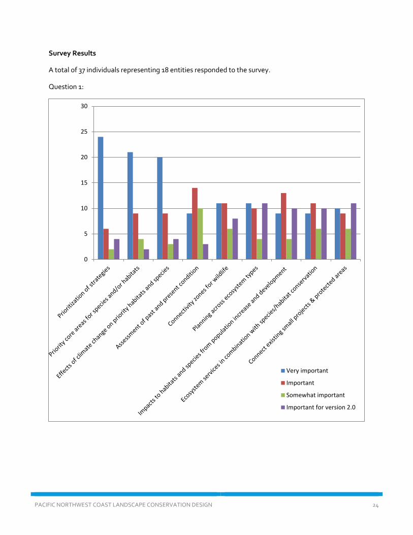
Survey Results
A total of 37 individuals representing 18 entities responded to the survey.
Question 1:
0
5
10
15
20
25
30
Very important
Important
Somewhat important
Important for version 2.0

PACIFIC NORTHWEST COAST LANDSCAPE CONSERVATION DESIGN 25
Question 2:
0
5
10
15
20
25