owned in life, owned in death: the pine street african and
TRANSCRIPT
Northeast Historical Archaeology
Volume 35 Article 22
2006
Owned in Life, Owned in Death: The Pine StreetAfrican and African-American BurialGround inKingston, New YorkJoseph E. Diamond
Follow this and additional works at: http://orb.binghamton.edu/neha
Part of the Archaeological Anthropology Commons
This Article is brought to you for free and open access by The Open Repository @ Binghamton (The ORB). It has been accepted for inclusion inNortheast Historical Archaeology by an authorized editor of The Open Repository @ Binghamton (The ORB). For more information, please [email protected].
Recommended CitationDiamond, Joseph E. (2006) "Owned in Life, Owned in Death: The Pine Street African and African-American BurialGround inKingston, New York," Northeast Historical Archaeology: Vol. 35 35, Article 22.https://doi.org/10.22191/neha/vol35/iss1/22 Available at: http://orb.binghamton.edu/neha/vol35/iss1/22
Owned in Life, Owned in Death: The Pine Street African and African-American BurialGround in Kingston, New York
Cover Page FootnoteThis article was originally presented in 2001 at the Sixty–Eighth Annual Meeting of the Eastern StatesArchaeological Federation, in Watertown NY as “Kingston’s African-American Burial Ground”. I would like tothank Mr. Edward Ford, City of Kingston Historian, for aiding in the rediscovery of the Pine Street Cemetery;Jane Kellar of the Friends of Historic Kingston, for providing maps that have been reproduced as figures in thetext; Alan Adin of the City of Kingston’s Planning and Engineering Department, for providing key maps thathave been reproduced as figures in the text; the members of the Not-For-Profit group “Kingston African-American Burial Ground Project”: McShell Moye-Clarke, Sidney Downey, Reverend James Childs, and Mr.Edward Stark, now deceased; Cara Muniz, for sending me all of her original notes on deed research from theUlster County Clerks Office. Dr. Mary Ekman of the Foreign Language Department at SUNY New Paltzprovided the original French translation for the French editor. Denise Oliver-Velez was kind enough to makecomments on a first draft. Finally, I would like to thank my wife, Rebecca Diamond, who is responsible forediting the manuscript, digital photography and graphics. Any errors are my own.
This article is available in Northeast Historical Archaeology: http://orb.binghamton.edu/neha/vol35/iss1/22
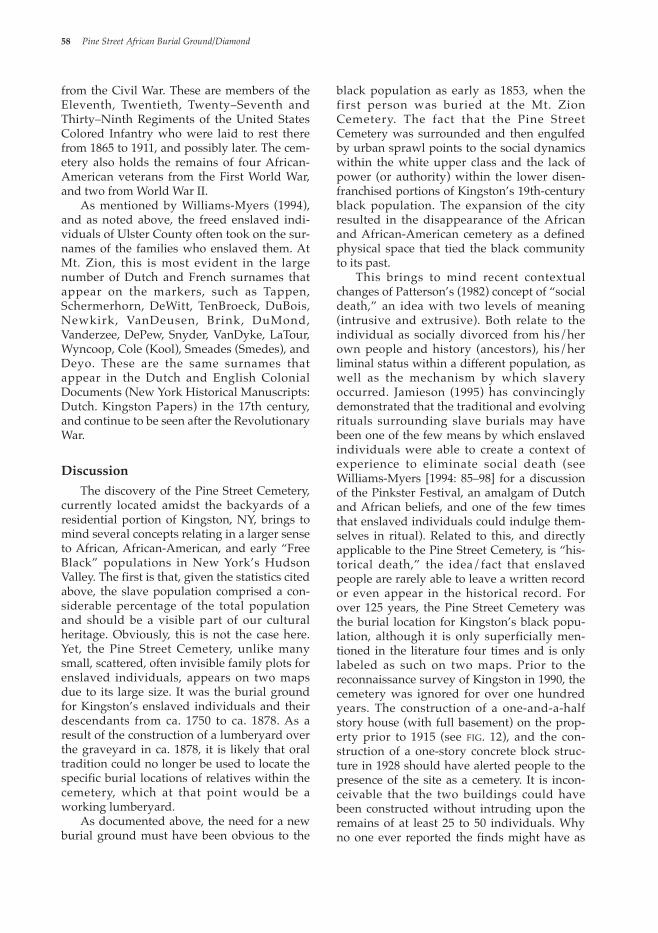
Introduction This study began in the summer of 1990 as a Phase 1A reconnaissance survey that attempted to locate a Negro “Cemetery” shown on the 1870 Beers Map of the City of Kingston, NY (fig. 1). This project was a col-laborative effort between the author and Kingston city historian Edwin Ford. While the project had success in recovering information about an important historic cemetery, the sig-nificance of the site was never fully embraced by the local community or the local govern-ment. As a result, this case highlights the prob-lematic intersection of historical memory and the politics of the present. During the pedestrian portion of the survey (Diamond 1990), a local resident, Mr. Andrew Kirschner, turned over a box of bones collected from beneath his concrete basement floor while repairing water lines. According to the 1870 Beers Map, his house is located along the northern border of the cemetery. We took the box of human remains and the Beers Map to the Kingston Police Department, who sent the remains on to the Onondaga County Medical Examiners Office. Forensic anthropologist Dr. William Rodriguez identified them as prob-ably African-American in origin. These human
remains are presumably from individuals buried in the Negro “Cemetery,” and the fact they were disturbed during basement utility work highlights the importance of our survey to reestablish the location of the historic ceme-tery. After being examined by Dr. Rodriquez, the remains were reportedly reburied at the Mount Zion Cemetery in Kingston. The burial location (as cited on the 1870 Beers Map) was given police protection by the City of Kingston for several days, but attention to the cemetery soon disappeared. A letter to Kingston’s Mayor, John Heitzman, explaining preservation concerns about the cemetery got little immediate response, but eventually, the cemetery was “flagged” by the Buildings Department in case of future construction. Shortly thereafter, in October 1990, letters from the Mayor’s Office of the City of Kingston stating the nature of the find went out to the owners of lots containing portions of the ceme-tery, as well as to the owners of adjacent prop-erties. In the spring of 1996, the owner of a lot encompassing about sixty percent of the ceme-tery decided to sell her parcel to a gentleman who was planning to construct a parking lot. Both parties were immediately informed by
Northeast Historical Archaeology/Vol. 35, 2006 47
Owned in Life, Owned in Death: The Pine Street African and African-American Burial Ground in Kingston, New York
Joseph E. Diamond In the summer of 1990, a Phase 1A Archaeological Reconnaissance of the City of Kingston, New York, resulted in the discovery of an 18th to 19th century African and African-American burial ground within the city limits of Kingston, NY. This area was designated specifically for African-American burials in 1750 and continued in use until it was engulfed by the southerly expansion of Kingston in the 1870s. Although small family graveyards of enslaved individuals have been found throughout the Hudson Valley, only two large cemeteries holding the remains of enslaved individuals and their descendants have been dis-covered. The Pine Street Cemetery in Kingston is one of the few cemeteries for enslaved individuals currently known that is almost as large as the African Burial Ground in New York City.
À l’été 1900, une reconnaissance archéologique de type 1A de la ville de Kingston dans l’état de New York a permis la découverte d’un lieu de sépulture Africain et Afro-Américain des XVIIIè et XIXè siè-cles. Cet endroit fut désigné spécifiquement pour les enterrements Afro-Américains en 1750 et servit jusqu’à son engloutissement dans la ville de Kingston dû à une expansion de la ville vers le sud dans les années 1870. Malgré le fait que des petits cimetières de famille contenant les dépouilles d’esclaves ont été trouvés ail-leurs dans la vallée de l’Hudson, seulement deux grands cimetières contenant les sépultures d’esclaves et de leurs descendants ont été mis au jour. Le Pine Street Cemetary à Kingston constitue l’un des seuls cimetières connus dont la taille s’approche de celui de la ville de New York.
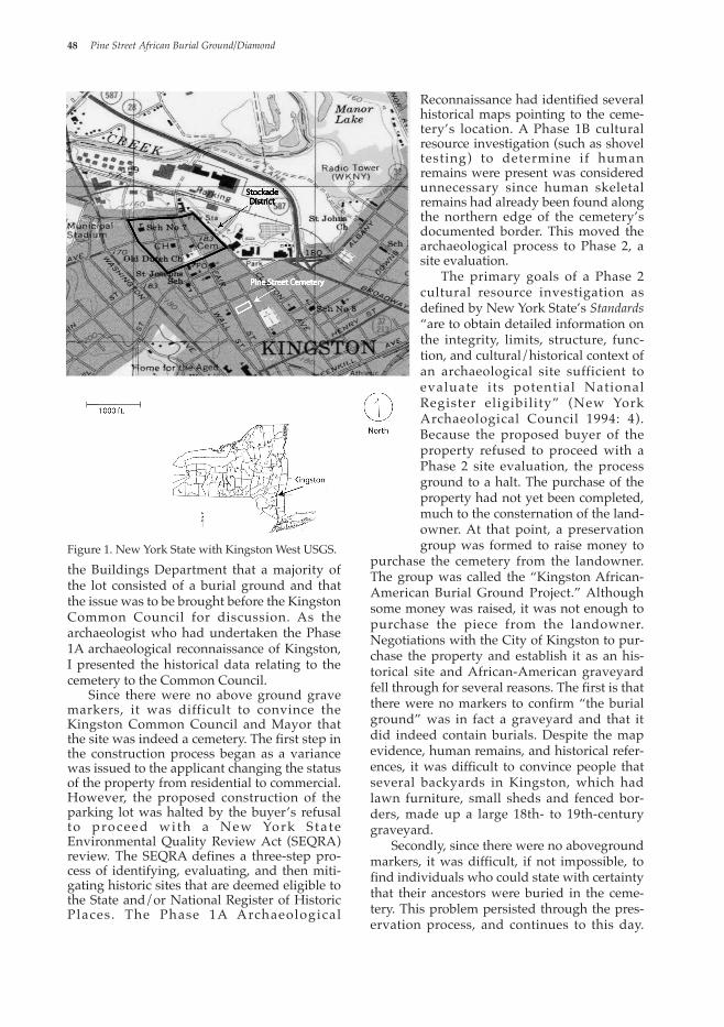
the Buildings Department that a majority of the lot consisted of a burial ground and that the issue was to be brought before the Kingston Common Council for discussion. As the archaeologist who had undertaken the Phase 1A archaeological reconnaissance of Kingston, I presented the historical data relating to the cemetery to the Common Council. Since there were no above ground grave markers, it was difficult to convince the Kingston Common Council and Mayor that the site was indeed a cemetery. The first step in the construction process began as a variance was issued to the applicant changing the status of the property from residential to commercial. However, the proposed construction of the parking lot was halted by the buyer’s refusal to proceed wi th a New York S ta te Environmental Quality Review Act (SEQRA) review. The SEQRA defines a three-step pro-cess of identifying, evaluating, and then miti-gating historic sites that are deemed eligible to the State and/or National Register of Historic Places. The Phase 1A Archaeological
Reconnaissance had identified several historical maps pointing to the ceme-tery’s location. A Phase 1B cultural resource investigation (such as shovel testing) to determine if human remains were present was considered unnecessary since human skeletal remains had already been found along the northern edge of the cemetery’s documented border. This moved the archaeological process to Phase 2, a site evaluation. The primary goals of a Phase 2 cultural resource investigation as defined by New York State’s Standards “are to obtain detailed information on the integrity, limits, structure, func-tion, and cultural/historical context of an archaeological site sufficient to evaluate its potential National Register eligibility” (New York Archaeological Council 1994: 4). Because the proposed buyer of the property refused to proceed with a Phase 2 site evaluation, the process ground to a halt. The purchase of the property had not yet been completed, much to the consternation of the land-owner. At that point, a preservation group was formed to raise money to
purchase the cemetery from the landowner. The group was called the “Kingston African-American Burial Ground Project.” Although some money was raised, it was not enough to purchase the piece from the landowner. Negotiations with the City of Kingston to pur-chase the property and establish it as an his-torical site and African-American graveyard fell through for several reasons. The first is that there were no markers to confirm “the burial ground” was in fact a graveyard and that it did indeed contain burials. Despite the map evidence, human remains, and historical refer-ences, it was difficult to convince people that several backyards in Kingston, which had lawn furniture, small sheds and fenced bor-ders, made up a large 18th- to 19th-century graveyard. Secondly, since there were no aboveground markers, it was difficult, if not impossible, to find individuals who could state with certainty that their ancestors were buried in the ceme-tery. This problem persisted through the pres-ervation process, and continues to this day.
48 Pine Street African Burial Ground/Diamond
Figure 1. New York State with Kingston West USGS.
Since no cemetery records exist, it is probable that the only means by which a list of the interred could be developed would be through a complicated and labor-intensive process of historical research, including the construction of family genealogies where dates of death and burial location would be determined. The third problem was that the graveyard had been sold and was now considered private property, an area of fuzzy jurisdiction under New York State Burial Law (New York State 1967). It was not owned or could not be con-strued as being owned by a church or even the City of Kingston, though the property was within the Corporate Boundary of the City. Because of the age of the cemetery, as well as the social position of its occupants, no “ceme-tery association” had ever been formed to pro-tect and care for the cemetery, as outlined in New York State Cemetery Law (New York State 2005). When the property was sold, it simply became private property. This is a trou-bling concept considering the context: the remains of enslaved individuals buried in the Pine Street Cemetery continue to be owned by other human beings—even in death. The fourth reason the property was not recognized as an African-American graveyard was that establishing the cemetery as an his-torical site would effectively remove it from the tax rolls. In contrast, the proposed parking lot construction would increase sales by allowing better access to an adjacent elec-tronics store, producing revenue and taxable property for the City of Kingston. Since there were no aboveground markers, the preservation plan for the cemetery would have involved new corner markers to delineate its boundaries, possibly the installation of some benches, and an interpretative sign. Because the Kingston African-American Burial Ground Project was unable to raise sufficient funds to purchase the property, and due to the City of Kingston’s apparent lack of interest, the members of the preservation group quickly realized that their efforts to purchase and restore the graveyard were futile. This futility of this effort was highlighted when the Friends of Historic Kingston voted against assisting the cemetery preservation group with fund-raising. Fortunately, a preservation-conscious individual, Mr. Dean Wilson, purchased the
property and has been instrumental in mini-mizing impacts to the site. In retrospect, the cemetery preservation group that was formed had at least four objec-tives. These were: site preservation; non-inva-sive archaeological investigations to determine site size; the re-establishment of the site as a graveyard/park; and concomitantly, the use of the site as a vehicle to interest African-American students in their past and in archae-ology. Of the four objectives, only the first has been satisfied.
Physical Characteristics The Pine Street Cemetery is rectangular in shape and currently consists of two lots, one fronting Pine Street, the other, extending almost to Fair Street. From measurements along the lot lines, the cemetery is about 225 ft (68.6 m) long east/west by 70 ft (21.3 m) wide north/south, with an approximate area of 17,850 sq ft (1461 sq m, 0.45 acre). The Fair Street lot appears to be about sixty percent cemetery, while the Pine Street lot is one hun-dred percent cemetery. About 190 ft (58 m) north of the Pine Street cemetery is St. James Street. At this point, the cemetery’s extent to the north and south beyond the present lot lines as defined in City Hall and on the 1870 Beers Map has not been determined. Cemeteries are often larger than they appear on maps due to additional burials placed near deceased friends and relatives, as well as prop-erty incursions by adjacent landowners over time. Small snippets of information appear throughout the map literature and histories of the City of Kingston, showing that the grave-yard did, in fact, exist. What the scant evidence points to is an 18th-century city, expanding and overtaking its former “Commons,” in much the same way New York City expanded and built over the African Burial Ground in lower Manhattan (Harrington 1993). In addi-tion to the historical documentation, the remains of four to six individuals of African ancestry identified by the Medical Examiner is physical evidence constituting what archaeolo-gists call “ground truth.” It is probable that this graveyard holds the remains of most of the enslaved African individuals, enslaved African-American individuals and “free blacks” who died in Kingston between the years ca.1750 and ca.1878, and perhaps even earlier. This bracketed date partially overlaps
Northeast Historical Archaeology/Vol. 35, 2006 49
with the widely publicized African Burial Ground in Lower Manhattan excavated in 1993 (Harrington 1993; La Roche and Blakey 1997).
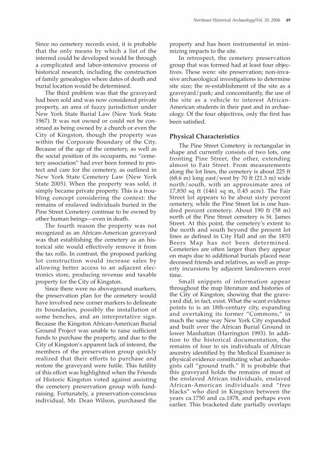
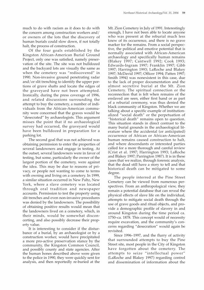
Historic Background In 1652, several Dutch families moved from Fort Orange (Albany) and settled on the flood-plain along the Esopus Creek near present day Kingston. Due to flooding along the Esopus Creek and the impending fear of Indian attack, the village of Wildwyck was constructed in 1658 by Peter Stuyvesant, with the help of sol-diers and members of the community in a for-tifiable location on a hilltop that is now “Uptown” Kingston (see also Fried 1975). The original stockade enclosed two long blocks of houses, which, due to a population increase, was expanded in ca. 1661 and then again in 1669–1670 after the English takeover of the set-tlement in 1664. The Miller View of 1695 is shown here as Figure 2. The African cemetery, which is the focus of this article, would have been to the south of the fort and the Dutch cemetery (which is located inside the southern edge of the stockade). As the population increased and the threat of warfare with the local Native Americans diminished, the stockades were removed and the original portion of the city expanded to the south. The small community that began as “Wildwyck,” and became “Kingston” by the late-17th century, would be burned by the English under General Vaughn in 1777, recover, and then grow to 20,000 inhabitants by 1888 (Blumin 1976; Schoonmaker 1888). Because of the social distance, color, and perceived moral differences between enslaved individuals and their owners,1 church burial had been denied enslaved individuals in New York since 1697. As a consequence, Africans and African-Americans were buried outside the city limits, usually in areas known as the Common Ground. In both the African Burial Ground in lower Manhattan (Harrington 1993; LaRoche and Blakey 1997), and the Pine Street Cemetery in Kingston, the burial ground was outside the fortified or palisaded area of the city. In the Manhattan example, the burial ground was labeled “Negro Burial Ground” on a 1755 map of the City of New York (Wilson 1994: 88). On an 1897 copy of an undated 18th-century map of the City of Kingston, there is an open section of land to the southeast of the city proper labeled “Armbowery” (fig. 3). This is an old Dutch term derived from arm
meaning “poor, needy or indigent” and bouwen, meaning in one sense, “to cultivate” (Renier 2001). Schoonmaker (1888: v) interprets this as a “poor farm” which was a large section of land randomly divided and used for pasture land, gardening, or social events, and was owned by no one, save the Commonality of Kingston, until the mid-18th century. Because more building lots were needed in the village, a section of the Armbowery was eventually divided up during a meeting of the Trustees of Kingston on October 6, 1750 (Trustees Records 1751, Book 2: 305, 308). The second purpose of this meeting was to locate a burying ground for the enslaved individuals. Schoonmaker notes:
At that time, without doubt, St. James Street
50 Pine Street African Burial Ground/Diamond
Figure 2. Approximate Location of Pine Street Cemetery in Relation to the City of Kingston in 1695 (1695 Miller Map).
1 I use the term “owner” rather than “master” throughout this paper, except where it occurs in quo-tation marks. This distinction, which is explained in detail by LaRoche and Blakey (1997: 93–94), is what I consider to be the most appropriate terminology.
was located, and the burying ground for col-ored people designated and laid out, on the west side of Pine Street about two hundred feet south of St. James Street, where it is now cov-ered by a lumberyard. It was used as a burying place for over one hundred years (1888: 199).
It should be noted that although this area was designated specifically for African-Americans in 1750, it does not mean that the area was not used for the burial of enslaved individuals in the years prior to 1750. Enslaved individuals in small villages or hamlets throughout Ulster County were commonly buried where they had lived and been enslaved. This can be observed at the Van Keuren Farm in Shawangunk (Hartgen Archaeological Associates 1989), and at the Terwilliger Farm in New Paltz, NY (several other slave cemeteries in the vicinity of Kingston and Hurley have been located, and since their discovery, have been either destroyed or looted). The enslaved individuals within Wildwyck (and later Kingston) prior to 1750 may have already been using the Armbowery as a burial place. It is conceivable that this lot was chosen by the Trustees of Kingston in 1750 because it was already being used as a graveyard, with or without the per-mission of the Commonality of the City of Kingston.
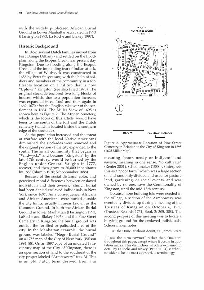
This open area of the Armbowery is also illustrated in a 1777 Map of Kingston (fig. 4) reproduced from Schoomaker (1888: 308). Here, the City of Kingston has expanded two blocks south of its 1695 limits. Within the Armbowery is a small dead end street t h a t r e a c h e s t h e c e m e t e r y. Schoonmaker states, “the colored burying-ground is numbered on the map as 113” (1888: 309). The 1820 map (fig. 5), also taken from Schoonmaker (1888: 436), illustrates several new city blocks in the “Plains or Water Ploss” to the east, but the cemetery and the short street reaching to it has not changed. Although the cemetery is no longer numbered, a house near the corner has been numbered 140. Its description is as follows:…a one-story frame house owned by Henry Houghtaling on the southwest corner of Pine Street. At this place Pine
Street terminated in 1820, about two hundred and fifty feet south of St. James Street, in a cul-de-sac, with the colored burying-ground on the west side thereof, in the rear of the Henry Houghtaling property (Schoonmaker 1888: 466).
Henry Houghtaling (variously spelled as Hoochteylingh, Hoghteling, Hogtilen, Hoochtalingh) was from one of the early fami-lies that populated the Village of Wildwyck during the 17th century. The family later estab-lished a larger cemetery on the east side of Pine Street, across from and south of the slave cemetery. The Houghtaling cemetery was not in existence in 1820, but by the mid- to late-19th century it appears on three maps relating to deeds on file at the County Clerk’s Office in Kingston. It seems as though the Houghtaling family owned a large portion of the Armbowery. Lot #141 on the 1820 Map (fig. 5) on the east side of Pine Street refers to “the old homestead of Teunis I. Houghtaling, and was occupied by him in 1820 with a frame wagon-maker’s shop at the south end thereof on Pine Street” (Schoonmaker 1888: 466). The Houghtaling Cemetery was moved via the “coroner’s method” in the 1970s for the con-struction of a medical clinic. John Vanderlyn, a native of Kingston and famous painter of Hudson Valley landscapes,
Northeast Historical Archaeology/Vol. 35, 2006 51
Figure 3. Late 18th-century map of Kingston.

produced a picturesque sketch of Kingston framed by the Catskill Mountains in 1819 (fig. 6), which illustrates the Armbowery, with Kingston in the background. Schoonmaker notes that this painting was “taken from the bluff of rocks a little to the east of the present juncture of Wall and Fair Streets. It presents in the foreground the fields, with their dividing fences, lying between the artist and St. James Street, which was then the most southerly street…on the territory designated as the ‘Armbowery’ (poor farm)” (1888: v). Due to the great distance between the painter and the cemetery, no grave markers are visible. It is most likely that if gravestones were present, they would be small stones
roughly hewn out of the local graywacke (or bluestone) with a minimum of decoration or no carvings at all. In New York State, inscribed headstones were a rarity for those of slave status. This is in contrast to certain areas in New England, where highly visible informa-tion pertaining to ownership and relationship between slave and owner is summarized on gravestones (Garman 1994). The gravestones of enslaved individuals in small family plots in the Hudson Valley rarely have inscriptions, and are usually constructed of fieldstone. The cemeteries are often located in marginal areas—such as hillsides, small hillocks, or
52 Pine Street African Burial Ground/Diamond
Figure 4. Cemetery location on 1777 map.
Figure 5. Cemetery location on 1820 map.
hilltop extensions that cannot be farmed or uti-lized for agricultural purposes.
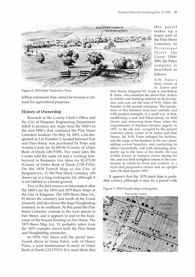
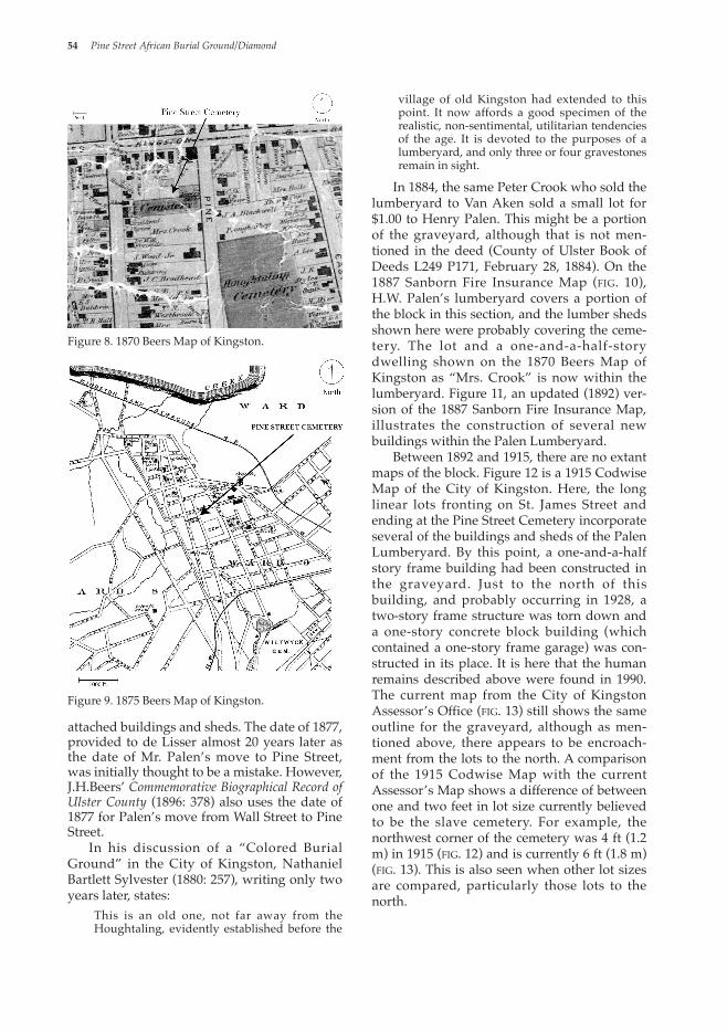
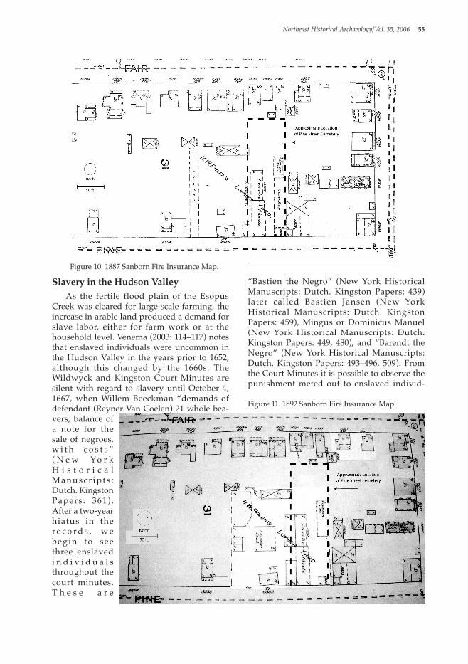
History of Ownership Research at the County Clerk’s Office and the City of Kingston Engineering Department failed to produce any maps from the 1830’s to the mid-1850’s that contained the Pine Street Cemetery location. On May 14, 1853, a lot des-ignated as Lot Number 3, located between Fair and Pine Street, was purchased by Peter and Amelia Crook for $1,600.00 (County of Ulster Book of Deeds L86 P258). Two years later, the Crooks sold the same lot and a working lum-beryard to Benjamin Van Aken for $2,475.00 (County of Ulster Book of Deeds L194 P156). On the 1858 French Map of the City of Kingston (fig. 7), the Pine Street Cemetery still shows up as a long rectangular lot, although it is not labeled as a burial ground. Two of the best sources of information after the 1860’s are the 1870 and 1875 Beers Maps of the City of Kingston. The 1870 Beers Map (fig. 8) shows the cemetery just north of the Crook property, and also shows the large Houghtaling cemetery to its southeast. At this point the Pine Street Cemetery extends to the west almost to Fair Street, and it appears to end in the back-yards of the houses fronting on Fair Street. The 1875 Beers Map (fig. 9), probably taken from the 1870 example, shows both the Pine Street and Houghtaling cemeteries. In 1878, Van Aken sold the parcel men-tioned above to Anna Palen, wife of Henry Palen, a local businessman (County of Ulster Book of Deeds L213 P515). It is most likely that
t h i s p a rc e l makes up a major part of the Pine Street Cemetery. In P i c t u r e s q u e U l s t e r ( d e Lisser 1896: 288), the Palen company is described as follows: H.W. Palen’s Sons, corner of St. James and
Pine Streets, Kingston NY. Frank A. and Burton B. Palen, who constitute the above firm, dealers in lumber and building material of all descrip-tion, and coal, are the sons of H.W. Palen, the founder of the present enterprise. The founda-tions of this business were laid carefully and with prudent foresight, in a small way at first, establishing a sash and blind factory on Wall Street, and removing from there when the requirements of business became urgent, in 1877, to the site now occupied by the present extensive plant, corner of St. James and Pine Streets. Mr. H.W. Palen enlarged his facilities, and the scope of his business at the new place, adding several branches, and conducting its affairs successfully, and with increasing pros-perity up to the time of his death. He was widely known in business circles during his life, and was held in highest esteem in the com-munity in which he lived and worked, as a loyal and progressive citizen and an upright man. He died April 6, 1893.
It appears that the 1878 deed date is prob-ably correct, although it may be a parcel with
Northeast Historical Archaeology/Vol. 35, 2006 53
Figure 6. 1819 John Vanderlyn View.
Figure 7. 1858 French Map of Kingston.
attached buildings and sheds. The date of 1877, provided to de Lisser almost 20 years later as the date of Mr. Palen’s move to Pine Street, was initially thought to be a mistake. However, J.H.Beers’ Commemorative Biographical Record of Ulster County (1896: 378) also uses the date of 1877 for Palen’s move from Wall Street to Pine Street. In his discussion of a “Colored Burial Ground” in the City of Kingston, Nathaniel Bartlett Sylvester (1880: 257), writing only two years later, states:
This is an old one, not far away from the Houghtaling, evidently established before the
village of old Kingston had extended to this point. It now affords a good specimen of the realistic, non-sentimental, utilitarian tendencies of the age. It is devoted to the purposes of a lumberyard, and only three or four gravestones remain in sight.
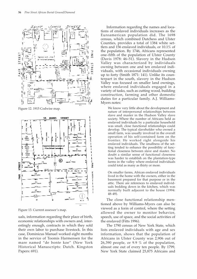
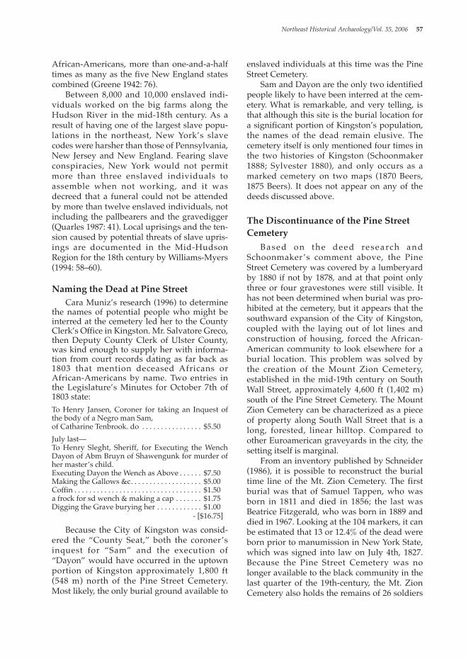
In 1884, the same Peter Crook who sold the lumberyard to Van Aken sold a small lot for $1.00 to Henry Palen. This might be a portion of the graveyard, although that is not men-tioned in the deed (County of Ulster Book of Deeds L249 P171, February 28, 1884). On the 1887 Sanborn Fire Insurance Map (fig. 10), H.W. Palen’s lumberyard covers a portion of the block in this section, and the lumber sheds shown here were probably covering the ceme-tery. The lot and a one-and-a-half-story dwelling shown on the 1870 Beers Map of Kingston as “Mrs. Crook” is now within the lumberyard. Figure 11, an updated (1892) ver-sion of the 1887 Sanborn Fire Insurance Map, illustrates the construction of several new buildings within the Palen Lumberyard. Between 1892 and 1915, there are no extant maps of the block. Figure 12 is a 1915 Codwise Map of the City of Kingston. Here, the long linear lots fronting on St. James Street and ending at the Pine Street Cemetery incorporate several of the buildings and sheds of the Palen Lumberyard. By this point, a one-and-a-half story frame building had been constructed in the graveyard. Just to the north of this building, and probably occurring in 1928, a two-story frame structure was torn down and a one-story concrete block building (which contained a one-story frame garage) was con-structed in its place. It is here that the human remains described above were found in 1990. The current map from the City of Kingston Assessor’s Office (fig. 13) still shows the same outline for the graveyard, although as men-tioned above, there appears to be encroach-ment from the lots to the north. A comparison of the 1915 Codwise Map with the current Assessor’s Map shows a difference of between one and two feet in lot size currently believed to be the slave cemetery. For example, the northwest corner of the cemetery was 4 ft (1.2 m) in 1915 (fig. 12) and is currently 6 ft (1.8 m) (fig. 13). This is also seen when other lot sizes are compared, particularly those lots to the north.
54 Pine Street African Burial Ground/Diamond
Figure 8. 1870 Beers Map of Kingston.
Figure 9. 1875 Beers Map of Kingston.
Slavery in the Hudson Valley As the fertile flood plain of the Esopus Creek was cleared for large-scale farming, the increase in arable land produced a demand for slave labor, either for farm work or at the household level. Venema (2003: 114–117) notes that enslaved individuals were uncommon in the Hudson Valley in the years prior to 1652, although this changed by the 1660s. The Wildwyck and Kingston Court Minutes are silent with regard to slavery until October 4, 1667, when Willem Beeckman “demands of defendant (Reyner Van Coelen) 21 whole bea-vers, balance of a note for the sale of negroes, w i t h c o s t s ” ( N e w Yo r k H i s t o r i c a l M a n u s c r i p t s : Dutch. Kingston Papers : 361) . After a two-year hiatus in the r e c o r d s , w e begin to see three enslaved i n d i v i d u a l s throughout the court minutes. T h e s e a r e
“Bastien the Negro” (New York Historical Manuscripts: Dutch. Kingston Papers: 439) later called Bastien Jansen (New York Historical Manuscripts: Dutch. Kingston Papers: 459), Mingus or Dominicus Manuel (New York Historical Manuscripts: Dutch. Kingston Papers: 449, 480), and “Barendt the Negro” (New York Historical Manuscripts: Dutch. Kingston Papers: 493–496, 509). From the Court Minutes it is possible to observe the punishment meted out to enslaved individ-
Northeast Historical Archaeology/Vol. 35, 2006 55
Figure 10. 1887 Sanborn Fire Insurance Map.
Figure 11. 1892 Sanborn Fire Insurance Map.
uals, information regarding their place of birth, economic relationships with owners and, inter-estingly enough, contracts in which they sold their own labor to purchase livestock. In this case, Dominicus Manuel worked eight months in the service of Toomis Harmensen for the mare named “de bonte koe” (New York Historical Manuscripts: Dutch. Kingston Papers: 691).
Information regarding the names and loca-tions of enslaved individuals increases as the Euroamerican population did. The 1698 census, which combined Dutchess and Ulster Counties, provides a total of 1384 white set-tlers and 156 enslaved individuals, or 10.1% of the population. By 1746, Africans represented one–fifth of the population of Ulster County (Davis 1978: 46–51). Slavery in the Hudson Valley was characterized by individuals owning between one and ten enslaved indi-viduals, with occasional individuals owning up to forty (Smith 1871: 141). Unlike its coun-terpart in the south, slavery in the Hudson Valley was focused on smaller land ownings, where enslaved individuals engaged in a variety of tasks, such as cutting wood, building construction, farming and other domestic duties for a particular family. A.J. Williams-Myers notes:
We know very little about the development and nature of interpersonal relationships between slave and master in the Hudson Valley slave society. Where the number of Africans held as enslaved individuals by a particular household was small, close functional relationships could develop. The typical slaveholder who owned a small farm, was usually involved in the overall operation of his self-contained farm on the frontier. He worked right alongside his enslaved individuals. The smallness of the set-ting tended to enhance the possibility of func-tional closeness between slave and master. No doubt a similar sense of functional closeness was harder to establish on the plantation-type farms in the valley where enslaved individuals could total as many as thirty or more.
On smaller farms, African enslaved individuals lived in the home with the owners, either in the basement prepared for that purpose or in the attic. There are references to enslaved individ-uals bedding down in the kitchen, which was normally built adjacent to the house (1994: 48–49).
The close functional relationship men-tioned above by Williams-Myers can also be viewed as a form of control, where the setting allowed the owner to monitor behavior, speech, use of space, and the social activities of the enslaved (Fitts 1996). The 1790 census of New York State, which lists enslaved individuals with age and sex information, shows that the population of Africans in Ulster County was 2,906 out of 26,390 people, or 9.9 % of the population, almost one out of every ten people. By 1799, New York State claimed 25,875 Africans and
56 Pine Street African Burial Ground/Diamond
Figure 12. 1915 Codwise map.
Figure 13. Current assessor’s map.
African-Americans, more than one-and-a-half times as many as the five New England states combined (Greene 1942: 76). Between 8,000 and 10,000 enslaved indi-viduals worked on the big farms along the Hudson River in the mid-18th century. As a result of having one of the largest slave popu-lations in the northeast, New York’s slave codes were harsher than those of Pennsylvania, New Jersey and New England. Fearing slave conspiracies, New York would not permit more than three enslaved individuals to assemble when not working, and it was decreed that a funeral could not be attended by more than twelve enslaved individuals, not including the pallbearers and the gravedigger (Quarles 1987: 41). Local uprisings and the ten-sion caused by potential threats of slave upris-ings are documented in the Mid-Hudson Region for the 18th century by Williams-Myers (1994: 58–60).
Naming the Dead at Pine Street Cara Muniz’s research (1996) to determine the names of potential people who might be interred at the cemetery led her to the County Clerk’s Office in Kingston. Mr. Salvatore Greco, then Deputy County Clerk of Ulster County, was kind enough to supply her with informa-tion from court records dating as far back as 1803 that mention deceased Africans or African-Americans by name. Two entries in the Legislature’s Minutes for October 7th of 1803 state:To Henry Jansen, Coroner for taking an Inquest of the body of a Negro man Sam,of Catharine Tenbrook. do . . . . . . . . . . . . . . . . $5.50July last—To Henry Sleght, Sheriff, for Executing the Wench Dayon of Abm Bruyn of Shawengunk for murder of her master’s child.Executing Dayon the Wench as Above . . . . . . $7.50Making the Gallows &c . . . . . . . . . . . . . . . . . . . $5.00Coffin . . . . . . . . . . . . . . . . . . . . . . . . . . . . . . . . . . $1.50a frock for sd wench & making a cap . . . . . . . $1.75Digging the Grave burying her . . . . . . . . . . . . $1.00 - [$16.75]
Because the City of Kingston was consid-ered the “County Seat,” both the coroner’s inquest for “Sam” and the execution of “Dayon” would have occurred in the uptown portion of Kingston approximately 1,800 ft (548 m) north of the Pine Street Cemetery. Most likely, the only burial ground available to
enslaved individuals at this time was the Pine Street Cemetery. Sam and Dayon are the only two identified people likely to have been interred at the cem-etery. What is remarkable, and very telling, is that although this site is the burial location for a significant portion of Kingston’s population, the names of the dead remain elusive. The cemetery itself is only mentioned four times in the two histories of Kingston (Schoonmaker 1888; Sylvester 1880), and only occurs as a marked cemetery on two maps (1870 Beers, 1875 Beers). It does not appear on any of the deeds discussed above.
The Discontinuance of the Pine Street Cemetery Based on the deed research and Schoonmaker ’s comment above, the Pine Street Cemetery was covered by a lumberyard by 1880 if not by 1878, and at that point only three or four gravestones were still visible. It has not been determined when burial was pro-hibited at the cemetery, but it appears that the southward expansion of the City of Kingston, coupled with the laying out of lot lines and construction of housing, forced the African-American community to look elsewhere for a burial location. This problem was solved by the creation of the Mount Zion Cemetery, established in the mid-19th century on South Wall Street, approximately 4,600 ft (1,402 m) south of the Pine Street Cemetery. The Mount Zion Cemetery can be characterized as a piece of property along South Wall Street that is a long, forested, linear hilltop. Compared to other Euroamerican graveyards in the city, the setting itself is marginal. From an inventory published by Schneider (1986), it is possible to reconstruct the burial time line of the Mt. Zion Cemetery. The first burial was that of Samuel Tappen, who was born in 1811 and died in 1856; the last was Beatrice Fitzgerald, who was born in 1889 and died in 1967. Looking at the 104 markers, it can be estimated that 13 or 12.4% of the dead were born prior to manumission in New York State, which was signed into law on July 4th, 1827. Because the Pine Street Cemetery was no longer available to the black community in the last quarter of the 19th-century, the Mt. Zion Cemetery also holds the remains of 26 soldiers
Northeast Historical Archaeology/Vol. 35, 2006 57
from the Civil War. These are members of the Eleventh, Twentieth, Twenty–Seventh and Thirty–Ninth Regiments of the United States Colored Infantry who were laid to rest there from 1865 to 1911, and possibly later. The cem-etery also holds the remains of four African-American veterans from the First World War, and two from World War II. As mentioned by Williams-Myers (1994), and as noted above, the freed enslaved indi-viduals of Ulster County often took on the sur-names of the families who enslaved them. At Mt. Zion, this is most evident in the large number of Dutch and French surnames that appear on the markers, such as Tappen, Schermerhorn, DeWitt, TenBroeck, DuBois, Newkirk, VanDeusen, Brink, DuMond, Vanderzee, DePew, Snyder, VanDyke, LaTour, Wyncoop, Cole (Kool), Smeades (Smedes), and Deyo. These are the same surnames that appear in the Dutch and English Colonial Documents (New York Historical Manuscripts: Dutch. Kingston Papers) in the 17th century, and continue to be seen after the Revolutionary War.
Discussion The discovery of the Pine Street Cemetery, currently located amidst the backyards of a residential portion of Kingston, NY, brings to mind several concepts relating in a larger sense to African, African-American, and early “Free Black” populations in New York’s Hudson Valley. The first is that, given the statistics cited above, the slave population comprised a con-siderable percentage of the total population and should be a visible part of our cultural heritage. Obviously, this is not the case here. Yet, the Pine Street Cemetery, unlike many small, scattered, often invisible family plots for enslaved individuals, appears on two maps due to its large size. It was the burial ground for Kingston’s enslaved individuals and their descendants from ca. 1750 to ca. 1878. As a result of the construction of a lumberyard over the graveyard in ca. 1878, it is likely that oral tradition could no longer be used to locate the specific burial locations of relatives within the cemetery, which at that point would be a working lumberyard. As documented above, the need for a new burial ground must have been obvious to the
black population as early as 1853, when the first person was buried at the Mt. Zion Cemetery. The fact that the Pine Street Cemetery was surrounded and then engulfed by urban sprawl points to the social dynamics within the white upper class and the lack of power (or authority) within the lower disen-franchised portions of Kingston’s 19th-century black population. The expansion of the city resulted in the disappearance of the African and African-American cemetery as a defined physical space that tied the black community to its past. This brings to mind recent contextual changes of Patterson’s (1982) concept of “social death,” an idea with two levels of meaning (intrusive and extrusive). Both relate to the individual as socially divorced from his/her own people and history (ancestors), his/her liminal status within a different population, as well as the mechanism by which slavery occurred. Jamieson (1995) has convincingly demonstrated that the traditional and evolving rituals surrounding slave burials may have been one of the few means by which enslaved individuals were able to create a context of experience to eliminate social death (see Williams-Myers [1994: 85–98] for a discussion of the Pinkster Festival, an amalgam of Dutch and African beliefs, and one of the few times that enslaved individuals could indulge them-selves in ritual). Related to this, and directly applicable to the Pine Street Cemetery, is “his-torical death,” the idea/fact that enslaved people are rarely able to leave a written record or even appear in the historical record. For over 125 years, the Pine Street Cemetery was the burial location for Kingston’s black popu-lation, although it is only superficially men-tioned in the literature four times and is only labeled as such on two maps. Prior to the reconnaissance survey of Kingston in 1990, the cemetery was ignored for over one hundred years. The construction of a one-and-a-half story house (with full basement) on the prop-erty prior to 1915 (see fig. 12), and the con-struction of a one-story concrete block struc-ture in 1928 should have alerted people to the presence of the site as a cemetery. It is incon-ceivable that the two buildings could have been constructed without intruding upon the remains of at least 25 to 50 individuals. Why no one ever reported the finds might have as
58 Pine Street African Burial Ground/Diamond
much to do with racism as it does to do with the concern among construction workers and/or owners of the lots that the discovery of human burials could slow down, if not totally halt, the process of construction. Of the four goals established by the Kingston African-American Burial Ground Project, only one was satisfied, namely preser-vation of the site. The site was not bulldozed and the backyard lots are visually the same as when the cemetery was “rediscovered” in 1990. Non-invasive ground penetrating radar and/or slit trenching to identify the upper por-tions of grave shafts and locate the edges of the graveyard have not been attempted. Ironically, during the press coverage of 1996, and related discussions surrounding the attempt to buy the cemetery, a number of indi-viduals from the African-American commu-nity were concerned that the graves would be “desecrated” by archaeologists. This argument misses the point that if no archaeological survey had occurred, the graveyard would have been bulldozed in preparation for a parking lot. The second goal that was not achieved was obtaining permission to enter the properties of several landowners and engage in testing. At the outset, several landowners were in favor of testing, but some, particularly the owner of the largest portion of the cemetery, were against the idea. This may be due to reasons of pri-vacy, or people not wanting to come to terms with owning and living on a cemetery. In 1999, a similar situation occurred in New Paltz, New York, where a slave cemetery was located through oral tradition and newspaper accounts. Permission to test the property using slit trenches and even non-invasive procedures was denied by the landowners. The possibility of obtaining positive results would mean that the landowners lived on a cemetery, which, in their minds, would be somewhat discon-certing, and also possibly decrease their prop-erty value. It is interesting to consider if the distur-bance of a burial, by an archaeologist or by a construction worker, would have precipitated a more pro-active preservation stance by the community, the Kingston Common Council, and possibly county and state agencies. After the human bones described above were given to the police in 1990, they were quickly sent for analysis, and then reportedly re-buried at the
Mt. Zion Cemetery in July of 1991. Interestingly enough, I have not been able to locate anyone who was present at the reburial much less knew of its occurrence, and there is no grave marker for the remains. From a social perspec-tive, the political and emotive potential that is normally associated with African-American archaeology and specifically human remains (Blakey 1997; Cantwell 1992; Cook 1993; Edwards-Ingram 1997; Franklin 1997; Gibb 1997; Harrington 1993; LaRoche and Blakey 1997; McDavid 1997; Officer 1994; Patten 1997; Smith 1994) was nonexistent in this case, due to the lack of proper documentation and the almost secretive burial at the Mt. Zion Cemetery. The spiritual connection or the reconnection that is felt when remains of the enslaved are seen, either first hand or as part of a reburial ceremony, was thus denied the black community of Kingston. Whether we are talking about a specific example of institution-alized “social death” or the perpetuation of “historical death” remains open to question. This situation stands in direct contrast to the many burial grounds in the archaeological lit-erature where the accidental (or anticipated) occurrence of African or African-American human remains caused construction to halt, and where descendants or interested parties called for a more thorough and careful review (Crist et al. 1997; Harrington 1993; LaRoche and Blakey 1997; Parrington 1987). It is in these cases that we realize, through forensic analysis, that the dead still have a story to tell and that historical death can be mitigated to some degree. The people interred at the Pine Street Cemetery can be viewed from numerous per-spectives. From an anthropological view, they remain a potential database that can reveal the physical effects of slave life on the individual, attempts to mitigate social death through the use of grave goods and ritual objects, and pro-vide a demographic profile of slavery in and around Kingston during the time period ca. 1750–ca. 1878. This concept would of necessity require excavation, and the community’s con-cerns regarding “desecration” would again be revisited. Since 1996–1997, and the flurry of activity that surrounded attempts to buy the Pine Street site, most people in the City of Kingston have forgotten about the cemetery. The attempts to seize “intellectual power” (LaRoche and Blakey 1997) regarding control and dissemination of information about the
Northeast Historical Archaeology/Vol. 35, 2006 59
cemetery have failed. The Pine Street Cemetery currently exists as the author observed in 1990, as a group of nondescript backyards.
Acknowledgements This article was originally presented in 2001 at the Sixty–Eighth Annual Meeting of the Eastern States Archaeological Federation, in Watertown NY as “Kingston’s African-American Burial Ground”. I would like to thank Mr. Edward Ford, City of Kingston Historian, for aiding in the rediscovery of the Pine Street Cemetery; Jane Kellar of the Friends of Historic Kingston, for providing maps that have been reproduced as figures in the text; Alan Adin of the City of Kingston’s Planning and Engineering Department, for providing key maps that have been reproduced as figures in the text; the members of the Not-For-Profit group “Kingston African-American Burial Ground Project”: McShell Moye-Clarke, Sidney Downey, Reverend James Childs, and Mr. Edward Stark, now deceased; Cara Muniz, for sending me all of her original notes on deed research from the Ulster County Clerks Office. Dr. Mary Ekman of the Foreign Language Department at SUNY New Paltz provided the original French translation for the French editor. Denise Oliver-Velez was kind enough to make comments on a first draft. Finally, I would like to thank my wife, Rebecca Diamond, who is responsible for editing the manuscript, digital photography and graphics. Any errors are my own.
References Beers, F.W. 1896 Commemorative Biographical Record of Ulster
County, New York: Containing Biographical Sketches of Prominent and Representative Citizens, and of Many of the Early Settled Families. Wilson, Humphreys and Co., Logansport, Indiana.
1870 Map of Kingston, NY. Large wall map on file, Friends of Historic Kingston.
1875 County Atlas of Ulster, New York. Walker and Jewett, 36 Vesey Street, NY.
Blakey, Michael L. 1997 Commentary: Past is Present: Comments on
“In the Realm of Politics: Prospects for Public Participation in African and African –American and Plantation Archaeology.” Historical Archaeology 31(3): 140–145.
Blumin, Stewart M. 1976 The Urban Threshold. The University of
Chicago Press, Chicago.
Cantwell, Anne-Marie 1992–1993 “Something Rich and Strange”:
Reburial in New York City. Northeast Historical Archaeology 21–22: 198–217.
Crist, Thomas A., Daniel G. Roberts, Reginal H. Pitts, John P. McCarthy and Michael Parrington.
1997 The First African Baptist Church Cemeteries: African-American Mortality and Trauma in Antebellum Philadelphia. In In Remembrance: Archaeology and Death, ed. by David Poirier and Nicholas Bellantoni, 19–49. Bergin and Garvey, Westport.
Codwise 1915 Map of the City of Kingston. On file in City
Of Kingston, Office of Planning and Engineering.
Cook, Karen 1993 Black Bones, White Science: The Battle Over
New York’s African Burial Ground. The Village Voice 5/4/93.
County of Ulster n.d. Book Of Deeds. On file at the Ulster County
Office Building, Fair Street, Kingston.
Davis, Thomas J. 1978 New York’s Long Black Line: A Note on the
Growing Slave Population, 1626–1790. Afro-Americans in New York Life and History 2: 41–59.
De Lisser, Richard Lionel 1896–1905 Picturesque Ulster. Originally Published
in Several Volumes, 1896–1905. 1968 Twines Catskill Bookshop Edition, Woodstock, NY.
Diamond, Joseph 1990 R e c o n n a i s s a n c e L e v e l S u r v e y o f
Archaeological Resources in the City of Kingston. Certified Local Government Program 1990. Manuscript on file New York State Office of Parks, Recreation and Historic Preservation.
Edwards-Ingram, Ywone 1997 Toward “True Acts Of Inclusion”: The
“Here” and the “Out There” Concepts in Public Archaeology. Historical Archaeology 31(3): 27–35.
Fitts, Robert K. 1996 The Landscapes of Northern Bondage.
Historical Archaeology 30(2): 54–73.
60 Pine Street African Burial Ground/Diamond
Franklin, Maria 1997 “Power to the people”: Sociopolitics and the
Archaeology of Black Americans. Historical Archaeology 31(3): 36–50.
French, J.H. 1858 Map of Ulster County, NY. Wall Map on file,
Friends of Historic Kingston.
Fried, Marc B. 1975 The Early History of Kingston and Ulster
County, N.Y. Ulster County Historical Society, Marbletown, N.Y.
Garman, James 1994 Viewing the Color Line Through the
Material Culture of Death. Historical Archaeology 28(3): 74–93.
Gibb, James B. 1997 Necessary but Insufficient: Archaeology
Reports and Community Action. Historical Archaeology 31(3): 51–64.
Greene, Lorenzo Johnston 1942 The Negro in Colonial New England 1620–
1776. Columbia University Press, New York.
Harrington, Spencer 1993 Bones and Bureaucrats: New York’s Great
Cemetery Imbroglio. Archaeology March/April: 28–38
Hartgen Archaeological Associates 1989 Phase 1A/1B Achaeological Investigation of
the Han Woo Subdivision, Town of Shawangunk, Ulster County, NY.
Jamieson, Ross W. 1995 Material Culture and Social Death: African-
American Burial Practices. Historical Archaeology 29(4): 39–58
La Roche, Cheryl J. and Michael L. Blakey 1997 Seizing Intellectual Power: The Dialogue at
the New York African Burial Ground. Historical Archaeology 31(3): 84–106.
Legislature’s Minutes, Commonality of Kingston 1803 Records of Expenditure for the Commonality,
translated from original documents recorded in Dutch. On microfilm at the County Clerk’s Office, Ulster County Office Building, Kingston.
McDavid, Carol 1997 Introduction to “In the Realm of Politics:
Prospects for Public Participation in African-American and plantation Archaeology.”
Historical Archaeology 31(3): 1–4.
Muniz, Cara 1996 The Pine Street Cemetery: Kingston’s
Forgotten African-American Burial Ground. Class Paper for “The Archaeology of Death.” SUNY New Paltz (5/10/96).
New York Archaeological Council (NYAC) 1994 Standards for Cultural Resource Investigation
and the Curation of Archaeological Collections in New York State.
New York State 1967 Selected New York State Laws Relating to
Cemeteries. The State Education Department Division of Archives and History, Albany, NY
2005 Relevant Laws, Administrative Rules & Regulations and Rules of Procedure of the State Cemetery Board Governing Cemetery & Crematory Operations. New York State Cemetery Board.
New York Historical Manuscripts: Dutch. Kingston Papers.
1661–1675 New York Historical Manuscripts: Dutch. Kingston Papers. Translated byDingman Versteeg, ed. by Peter R. Christoph, Kenneth Scott, and Kenn Stryker-Rodda. 2 Volumes. Published under the direction of the Holland Society 1976. Genealogical Publishing, Baltimore.
Officer, Debbie 1994 Last Rites. African Voices. March: 4–5.
Parrington, Michael 1987 Cemetery Archaeology in the Urban
E n v i ro n m e n t : a C a s e S t u d y f ro m Philadelphia. In Living in Cities: Current Research in Urban Archaeology, ed. by Edward Staski, 56–64. Special Publication Series 5. Society for Historical Archaeology, California, PA.
Patten, Drake M. 1997 Cheers of Protest? The Public, the Post, and
the Parable of Learning. Histor ica l Archaeology 31(3): 132–139.
Patterson, Orlando 1982 Slavery and Social Death: A Comparative Study.
Harvard University Press, Cambridge, Massachusetts.
Quarles, Benjamin 1987 The Negro in the Making of America. Revised
Edition. MacMillan Publishing, New York
Northeast Historical Archaeology/Vol. 35, 2006 61
Renier, Fernand G. 2001 Dutch Dictionary: Dutch-English and English-
Dutch. Routledge, London.
Sanborn Fire Insurance Map. 1887 On file in City Of Kingston, Office of
Planning and Engineering.
Sanborn Fire Insurance Map. 1892 On file in City Of Kingston, Office of
Planning and Engineering.
Schneider, Gail 1986 A Beginning Investigation into the Afro-
American Cemeteries of Ulster County, New York. Afro-Americans in New York Life and History January: 61–70.
Schoonmaker, Marius 1888 The History of Kingston, New York: From Its
Early Settlement to the Year 1820. Burr Printing House, New York
Smith, Charles C. 1994 In the Presence of Ancestors. Massachusetts
Fall: 10–21.Smith, Philip H. 1871 General History of Dutchess County from 1609
to 1876, Inclusive. Pawling, NY.
Sylvester, Nathaniel Bartlett 1880 History of Ulster County: With Illustrations and
Biographical Sketches of its Prominent Men and Pioneers. Everts and Peck, Philadelphia.
Trustees Records, County of Ulster, New York 1751 25 January, Book 2: 305; 19 February, Book 2:
308. On file at the Ulster County Office Building, Kingston.
Venema, Janny 2003 Beverwyck: A Dutch Village on the American
Frontier, 1652–1664. State University Press, Albany.
Williams-Myers, A.J. 1994 Long Hammering: Essays on the Forging of an
African-American Presence in the Hudson Valley to the Early Twentieth Century. Africa World Press, Trenton.
Wilson, Sherrill D. 1994 New York City’s African Slaveowners. Garland
Publishing, New York.
Joseph Diamond is Assistnat Professor of Anthropology at SUNY New Paltz. He earned his M.A. from New York University and his doctorate from SUNY Albany. His research interests include the Late Woodland Period, 17th-century Contact, New Netherland and the Dutch Colonial Period, and 17th-century Huguenot occupations in the Hudson Valley.
Joseph E. Diamond, Ph.D.Department of AnthropologySUNY New Paltz, Wooster Science Bldg. 124New Paltz,NY [email protected]
62 Pine Street African Burial Ground/Diamond