overview of the rogersville shale in west … of the rogersville shale in west virginia. ......
TRANSCRIPT
Philip DintermanWest Virginia Geological & Economic Survey
May 11, 2017
OVERVIEW OF THE ROGERSVILLE SHALEIN WEST VIRGINIA

ACKNOWLEDGEMENT Dave Harris, John Hickman, Kentucky Geological Survey
All Data Presented is publicly available and/or acquired from publicly available material
DATA NOTE

OUTLINE
ROGERSVILLE SHALE INFORMATIONROME TROUGHPREVIOUS AND ONGOING WORKCORE DATARECENT ACTIVITY

IN THE APPALACHIAN BASIN THE MARCELLUS AND UTICA-POINT PLEASANT DOMINATE SHALE GAS PRODUCTION,
WHILE THE ROGERSVILLE IS NOT LISTED AS A CURRENT OR PROSPECTIVE PLAY…..
WILL THIS CHANGE?

AN EMERGING PLAY?
What makes the Rogersville different than the Marcellus or Utica-Point Pleasant?
Does the Rogersville have the potential to be a productive play in West Virginia?
If it does have potential, what are the reasons it has not been developed yet?

GENERAL ROGERSVILLE SHALEINFORMATION
Unit within the Cambrian-age ConasaugaGroup
Middle Cambrian ~500 Million Years OldOrganic-rich dark shale mixed with siltstone
and carbonatesDepth ~10,000-17,000 feet in WV (in KY 5,000-
10,000 feet deep)Thickness 0 - 1,000+ feet (not all is organic rich)

WHERE IS THE ROGERSVILLE IN WEST VIRGINIA?
Rogersville-(depending on location) is…..7,000-9000 feet below Marcellus~5,000 feet below Utica-Point PleasantDeposition limited to within the Rome
Trough

Middle Cambrian Paleogeography
Rogersville Deposition
Ron Blakey, Colorado Plateau Geosystems, Arizona USA
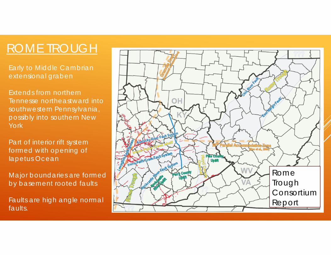
ROME TROUGH
Rome Trough Consortium Report
Early to Middle Cambrian extensional graben
Extends from northern Tennesse northeastward into southwestern Pennsylvania, possibly into southern New York
Part of interior rift system formed with opening of Iapetus Ocean
Major boundaries are formed by basement rooted faults
Faults are high angle normal faults.

ROME TROUGHMajor boundaries are formed by basement rooted faults
Faults are high angle normal faults.

GRABEN ARCHITECTURE
Extensional setting
“Pulling apart” of landmass
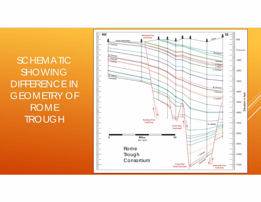
SCHEMATIC SHOWING
DIFFERENCE IN GEOMETRY OF
ROME TROUGH
Rome TroughConsortium

ROME TROUGH STRATIGRAPHY
Rome Trough Consortium

ROME TROUGH (ROGERSVILLE HIGHLIGHTED)
WV VAKY WVUSGS Cross Section G-G’I-Map 2530
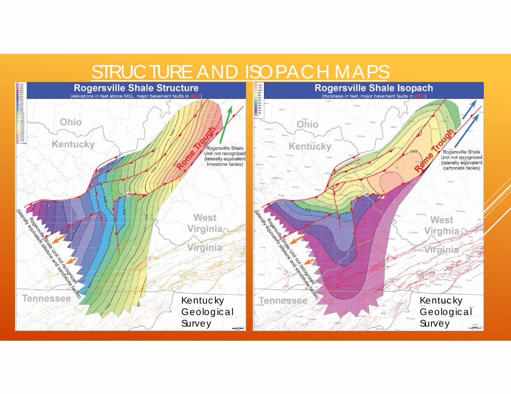
STRUCTURE AND ISOPACH MAPS
Kentucky GeologicalSurvey
Kentucky GeologicalSurvey

WHAT IS OUR DATA BASED UPON?

West Virginia12 Wells Penetrate Rogersville Equivalent Interval
2 Wells are in structurally complex eastern part of state, and outside of Rome Trough-therefore Rogersville
Most wells were drilled in 1970’s
Well in Mason County, drilled in 2003, was a CO2 sequestration test, no Rogersville present.
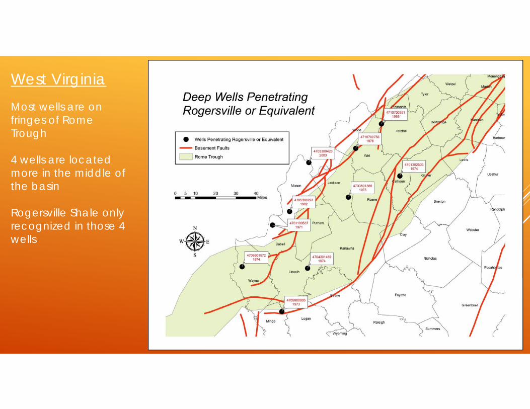
West VirginiaMost wells are on fringes of Rome Trough
4 wells are located more in the middle of the basin
Rogersville Shale only recognized in those 4 wells

PREVIOUS AND ONGOING WORK

PREVIOUS WORK
Rome Trough Consortium (1999-2002, Report Available) Multistate project (WV, KY, OH) Mapped individual units in the Rome Trough Correlated across state lines Focused on conventional reservoirs
U.S. Geological Survey Open File Report 05-1443 https://pubs.usgs.gov/of/2005/1443/2005-1443.pdf

DIP CROSS SECTION ACROSS NORTH CENTRAL WEST VIRGINIA
Rome TroughConsortium

STRIKE CROSS SECTION THROUGH ROME TROUGH, WEST VIRGINIA
SW NE
Rome TroughConsortium

USGS OPEN FILE REPORT 05-1443
Noted that Rogersville could be a source rock
CORE DATA

EXXON JAY SMITH #1-THE CORE THAT STARTED IT ALL
Well Drilled in 1974
Depth-14625 Feet to Precambrian
Plugged in 1975
WVGES has core from several intervals in this well.
Rogersville core is 11,135-11,200 Feet

Jay P Smith #1API 4709901572TOC in Rogersville 4.4% from Rome Trough Consortium work
TOC measurements similar or higher than Utica-Point Pleasant
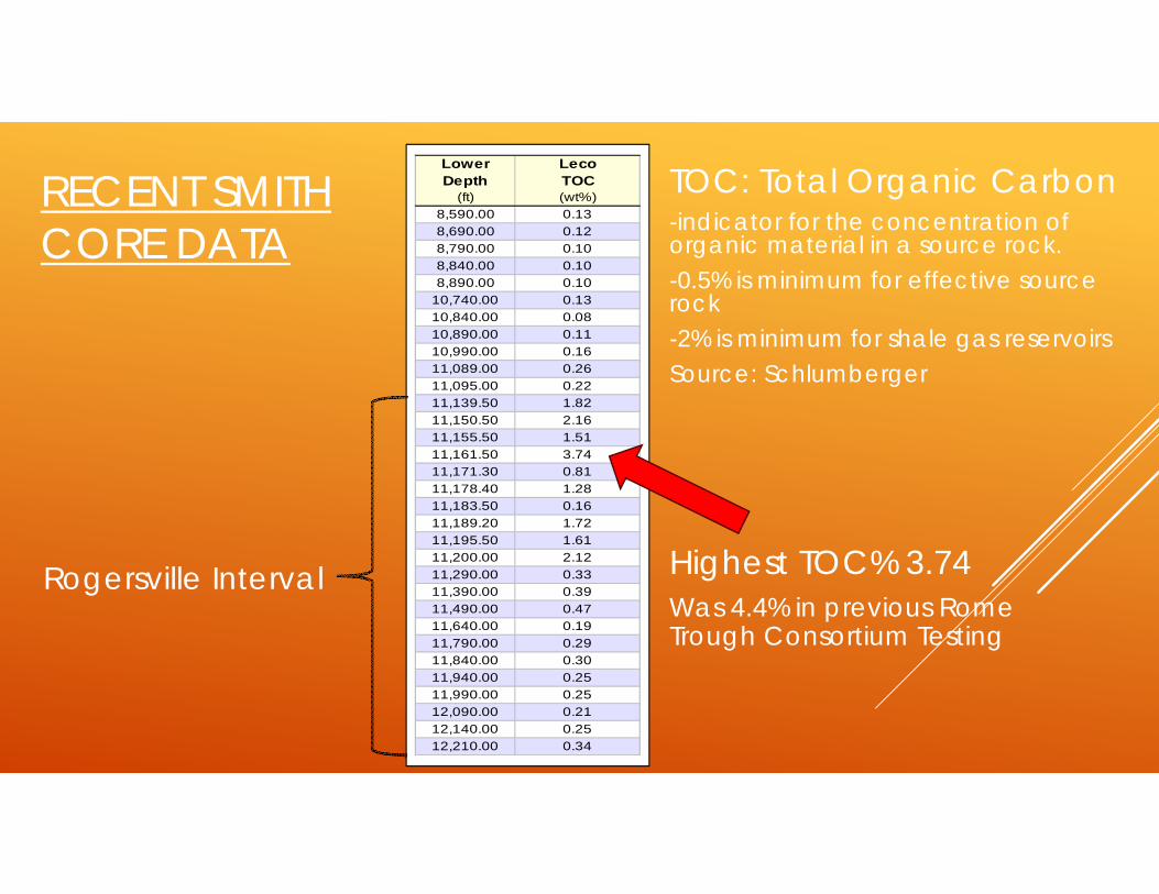
RECENT SMITH CORE DATA
Highest TOC% 3.74Was 4.4% in previous Rome Trough Consortium Testing
Lower LecoDepth TOC
(ft) (wt%)8,590.00 0.138,690.00 0.128,790.00 0.108,840.00 0.108,890.00 0.10
10,740.00 0.1310,840.00 0.0810,890.00 0.1110,990.00 0.1611,089.00 0.2611,095.00 0.2211,139.50 1.8211,150.50 2.1611,155.50 1.5111,161.50 3.7411,171.30 0.8111,178.40 1.2811,183.50 0.1611,189.20 1.7211,195.50 1.6111,200.00 2.1211,290.00 0.3311,390.00 0.3911,490.00 0.4711,640.00 0.1911,790.00 0.2911,840.00 0.3011,940.00 0.2511,990.00 0.2512,090.00 0.2112,140.00 0.2512,210.00 0.34
Rogersville Interval
TOC: Total Organic Carbon-indicator for the concentration of organic material in a source rock.-0.5% is minimum for effective source rock-2% is minimum for shale gas reservoirsSource: Schlumberger

EXXON SMITH CORE DATA CONTINUED
0.00
0.10
0.20
0.30
0.40
0.50
0.60
0.70
0.80
0.90
1.00
380 400 420 440 460 480 500 520 540 560 580 600
Ker
ogen
Con
vers
ion,
PI (
S1/(S
1+S2
)
Tmax (C)
Immature Dry Gas ZoneOil Zone CondensateWet Gas
Zone
Stained or Contaminated
Low Level Conversion
Kerogen: naturally occurring solid, insoluble organic matter that occurs in source rocks and can yield oil upon heating (Schlumberger)
Kerogen Conversion & Maturity

EXXON SMITH CORE DATA CONTINUED
Graph shows depth vs normalized oil content
Indication of Maturity
0 20 40 60 80 1008,000
8,500
9,000
9,500
10,000
10,500
11,000
11,500
12,000
12,500
13,0000 50 100 150 200 250 300
Mea
sure
d D
epth
, MD
(ft)
Normalized Oil Content, S1/TOC
S1/TOC
% Carbonate
% Carbonate
Low
M
atur
ity
Ear
ly
Mat
ure
Mature / Stained
Oil / Gas Production or Contamination

RECENT CORE DATA FROM SEVERAL WV WELLS
Depth () LecoTop TOC
Jay Smith 1:1 11000 0.292 11139 1.592 11139 1.413 11144 2.203 11144 1.494 11150 1.784 11150 1.905 11153 1.935 11153 1.816 11161 2.826 11161 2.907 11189 0.457 11189 0.138 11198 1.639 11200 1.839 11200 1.9410 11590 0.27
McCoy:11 14530 0.1812 15030 0.19
McCormick:13 14146 0.2814 14240 0.2715 14280 0.16
Fee 9674:16 14004 0.3717 14380 0.19
Client ID
Other wells show much lower TOC% (nothing over 0.5%)
Not all are from Rogersville interval

CORE DATA CONCLUSIONS
Up to 4.4% TOC, but TOC is highly variable within wells and within Rome Trough
Rogersville has generated gas and condensate. West Virginia is in the wet to dry gas transition zone
Most of the Rogersville in West Virginia is thermally mature
Only the Smith core shows good source rock data.

RECENT ACTIVITY
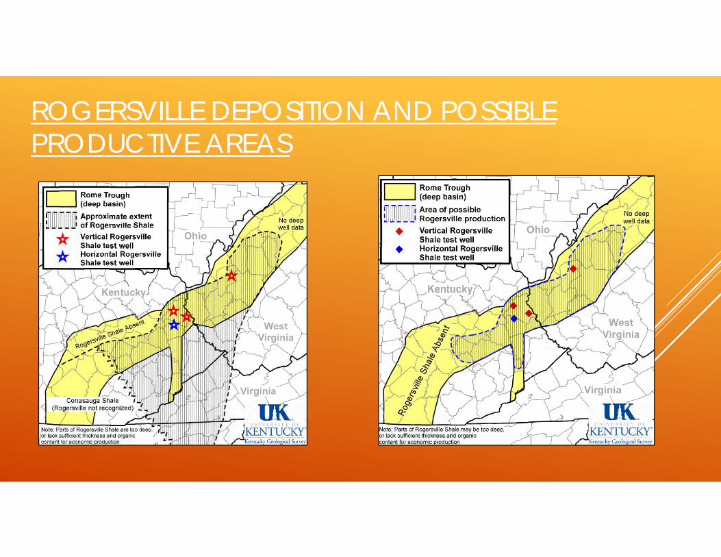
ROGERSVILLE DEPOSITION AND POSSIBLE PRODUCTIVE AREAS
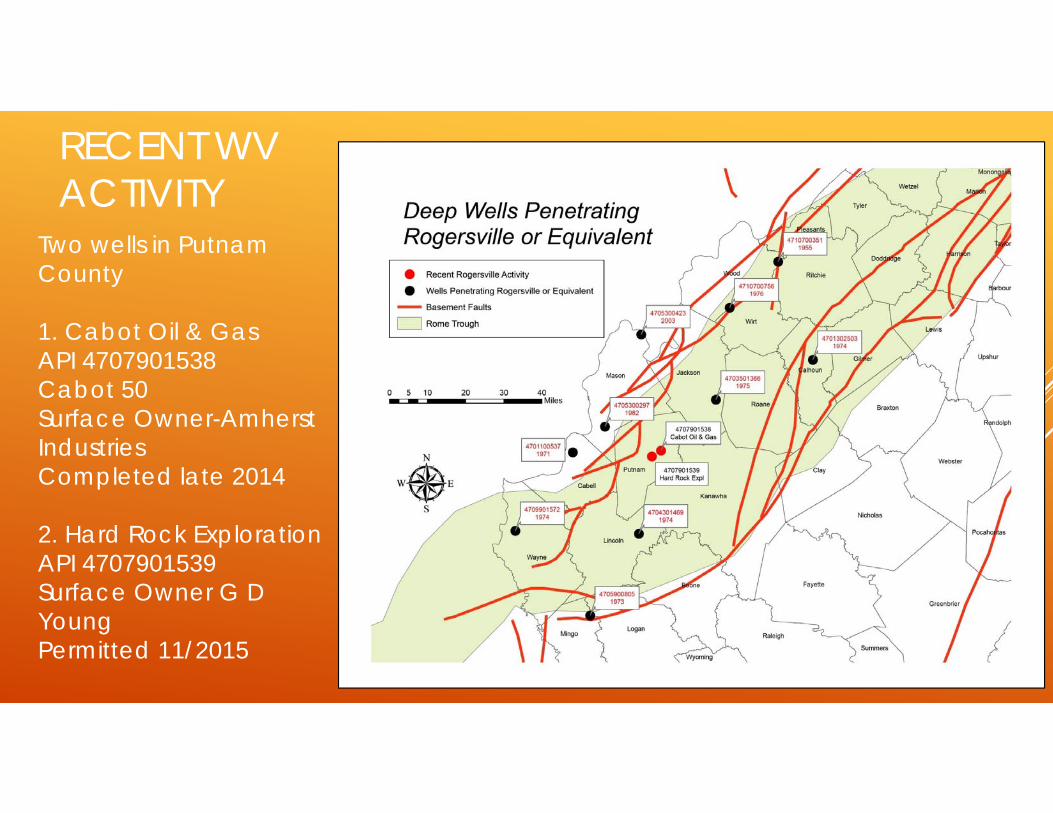
RECENT WV ACTIVITY
Two wells in Putnam County
1. Cabot Oil & GasAPI 4707901538 Cabot 50Surface Owner-Amherst IndustriesCompleted late 2014
2. Hard Rock ExplorationAPI 4707901539Surface Owner G D YoungPermitted 11/2015

CABOT 50
Vertical WellUnsure if producing
zone is RogersvilleRecords held
confidential by WV Conservation Commission

CURRENT ACTIVITYSix wells drilled to date:
1. Bruin Expl. (Cimarex): apparent discovery (shut-in) Lawrence Co., KY
2. Cabot Oil & Gas: 1 vertical, Putnam Co., West Virginia, producing dry gas
3 & 4. Chesapeake Energy: 2 verticals (shut-in), Lawrence County, KY
5. Horiz. Tech. Energy (EQT): 1 horizontal, (under evaluation?), Johnson Co., KY
6. Bruin Expl. (Cimarex): 2nd well, horizontal, Lawrence Co., Ky.
Two undrilled horizontal lateral permits in KY
Chesapeake LAW1 Northup EstBruin Expl 1 Walbridge
Hard Rock Expl 1 Young, GD
Cabot 50 Amherst Industries
Chesapeake LAW1 Stephens, J
Bruin Expl 1 Young, S
Horiz. Tech Energy 572360 EQT
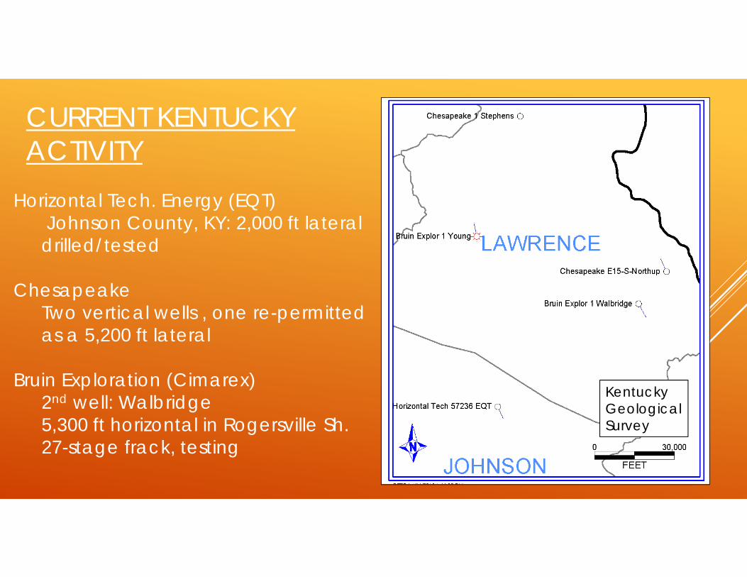
CURRENT KENTUCKY ACTIVITY
Horizontal Tech. Energy (EQT)Johnson County, KY: 2,000 ft lateral drilled/tested
ChesapeakeTwo vertical wells , one re-permitted as a 5,200 ft lateral
Bruin Exploration (Cimarex)2nd well: Walbridge5,300 ft horizontal in Rogersville Sh.27-stage frack, testing
Kentucky GeologicalSurvey

IMPLICATIONS
This activity has generated active leasing
Stacked potential is limited
However, could easily connect to pipeline and refinery infrastructure
Chesapeake Investor Report

AN EMERGING PLAY? What Makes the Rogersville Different than the Marcellus or Utica-Point
Pleasant? Depth, Complex Structural System, Depositional System
Does the Rogersville have the potential to be a productive play in West Virginia? Yes, but may not be as geographically expansive as Marcellus or Utica-Point
Pleasant
If it does have potential, what are the reasons it has not been developed yet? Sparse dataset, Depth (Increases Cost, some Horizontal Utica-Point Pleasant
wells have price tags north of $20 Million, Most Likely Dry Gas

CIMAREX WALBRIDGE 1H FLARE (4-26-2017)
AN INTRIGUING TARGET…..

THANK YOU
QUESTIONS?