overview of technology products for the beef industry of ... · overview of technology products for...
TRANSCRIPT

Overview of technology products for the beef industry of remote Australia Sally LeigoGreg BrennanTerry BeutelAnthony GrayDavid PhelpsTim DriverMark Trotter
Working paper
CW009 2012
PrecisionPastoral
Precision Pastoral Management Tools

Cooperative Research Centre for Remote Economic Participation Working Paper CW009 ISBN: 978-1-74158-219-2 Contributing author information • Ms Sally Leigo: CRC for Remote Economic Participation and Department of Primary Industry and
Fisheries, Alice Springs, Northern Territory (corresponding author – email: [email protected])
• Mr Greg Brennan: Department of Agriculture and Food, Geraldton, Western Australia • Dr Terry Beutel: Department of Agriculture, Fisheries and Forestry, Rockhampton, Queensland • Mr Anthony Gray: Department of Agriculture and Food, Geraldton, Western Australia • Dr David Phelps: Department of Agriculture, Fisheries and Forestry, Longreach, Queensland • Mr Tim Driver: Precision Pastoral Pty Ltd, Alice Springs, Northern Territory • Dr Mark Trotter: University of New England, Armidale, New South Wales Citation Leigo S, Brennan G, Beutel T, Gray A, Phelps D, Driver T and Trotter M. 2012. Overview of technology
products for the beef industry of remote Australia. CRC-REP Working Paper CW009. Ninti One Limited, Alice Springs.
Acknowledgement The Cooperative Research Centre for Remote Economic Participation receives funding through the Australian Government Cooperative Research Centres Program. The views expressed herein do not necessarily represent the views of CRC-REP or its Participants. Disclaimer This review is provided in good faith as general information; it is not intended to be a comprehensive list and the authors do not endorse any of the products listed in this review. For additional information please contact Ninti One Limited Communications Manager PO Box 154, Kent Town SA 5071 Australia Telephone +61 8 8959 6000 Fax +61 8 8959 6048 www.nintione.com.au © Ninti One Limited 2012

Overview of technology products for the beef industry of remote Australia
Sally Leigo
Greg Brennan
Terry Beutel
Anthony Gray
David Phelps
Tim Driver
Mark Trotter

CRC-REP Working Paper CW009
ii Overview of technology products for the beef industry of remote Australia Ninti One Limited
Contents
1. Introduction ......................................................................................................................................... 1
2. Methodology ....................................................................................................................................... 2
3. Results ................................................................................................................................................. 3
3.1 Pasture technology products .......................................................................................................... 3 3.1.1 Remote monitoring ................................................................................................................ 3
3.1.2 Pasture modelling ................................................................................................................... 8
3.1.3 Mapping programs ............................................................................................................... 11
3.1.4 Management software .......................................................................................................... 14
3.2 Cattle technology products.......................................................................................................... 16 3.2.1 Remote monitoring .............................................................................................................. 16
3.2.2 Herd Modelling .................................................................................................................... 20
3.2.3 Remote management ............................................................................................................ 22
3.2.4 Livestock management software .......................................................................................... 24
3.3 Other technology products .......................................................................................................... 28
4. Conclusions ....................................................................................................................................... 30
References ............................................................................................................................................. 31
CRC-REP Working Paper CW009
Ninti One Limited Overview of technology products for the beef industry of remote Australia iii
Figures
Figure 1: Map of remote Australia .......................................................................................................... 1
Figure 2: Categorisation of technology products for the beef industry of remote Australia................... 2
Tables
Table 1: Summary of pasture remote monitoring tools .......................................................................... 5
Table 2: Summary of pasture modelling tools ........................................................................................ 9
Table 3: Summary of mapping programs ............................................................................................. 12
Table 4: Summary of pasture management software ............................................................................ 15
Table 5: Summary of animal remote monitoring .................................................................................. 18
Table 6: Summary of herd modelling ................................................................................................... 21
Table 7: Summary of remote management of cattle ............................................................................. 23
Table 8: Summary of livestock management software ......................................................................... 26
Table 9: Summary of other technology products .................................................................................. 29


CRC-REP Working Paper CW009
Ninti One Limited Overview of technology products for the beef industry of remote Australia 1
1. Introduction Remote Australia makes up 86% of Australia’s land mass (CRC-REP 2012), yet its residents form just 2.7% of the Australian population (ABS 2003); they are scattered sparsely throughout the region (see Figure 1). Within this broad area, the beef industry is a large contributor to the local economy and user of the landscape. Beef production in remote Australia occurs on large extensive properties (40–15,750 km2) from native or improved pastures and is owned by family businesses and private or public companies. The industry supplies beef to both domestic and international markets.
Figure 1: Map of remote Australia
Source: CRC-REP 2012
Embracing innovative ideas and new technology has allowed beef producers in remote Australia to overcome the challenges of distance, isolation and the natural environment to improve their businesses. Whether it has been through the introduction of technologies such as calf cradles, telecommunications, road trains or DNA testing, beef producers have decreased costs, increased production and production efficiency and improved the welfare of the animal. The escalation of costs over the past decade has seriously compromised the financial viability of the northern Australian beef industry. An analysis of economic benchmarking across northern Australia during the ten-year period 1999–2008 stated that there had been a significant escalation in costs, and average debt levels per large stock unit had doubled; returns on assets were 0.3–2.0%, and the northern beef industry is generally in a very unprofitable and unsustainable state (McCosker et al. 2009). In addition, the industry continues to feel the impact of the live export ban of 2011 and the market restrictions imposed by the Indonesian Government. The change in the live export market has resulted in a decrease in the price received for sale cattle and decreased land values, impacting on equity levels.. This harsh economic reality places serious pressure on both producers and the service providers to rapidly seek opportunities to increase beef production sustainably. Adopting new technologies provides beef producers with opportunities to improve herd productivity and reduce costs.
In this working paper the authors outline 60 existing, new and emerging technologies that are relevant to beef producers in remote Australia as well as to industry researchers and service providers. Not all of the products listed are available or suitable for beef producers, but these products do offer a glimpse into what may be possible for remote Australia’s beef industry.

CRC-REP Working Paper CW009
2 Overview of technology products for the beef industry of remote Australia Ninti One Limited
2. Methodology Sixty technology products were selected for review in this working paper. The criteria used to select these products were whether they could be of benefit for beef producers in managing their operation, or whether the product could provide additional real time information on property locations or weather. In using these criteria a large range of products were listed, reflecting the requirements of a manager of a beef producing property. Figure 2 shows how the technology products were categorised and the number of products reviewed per category. These products could enhance producers’ ability to monitor pasture and cattle performance, model pasture and herd growth, map the property, remotely manage their cattle or manage the vast amounts of data collected for either pasture or cattle performance.
Figure 2: Categorisation of technology products for the beef industry of remote Australia
Within each of the categories, products were selected on their ability to meet at least one of the following criteria:
• new technology products available to beef producers • emerging technology products either at a development or prototype stage • existing technology products only beginning to be used by beef producers • technology products not available to beef producers but used by researchers • technology products not suitable for Australian beef producers currently but may become available or
suitable in the future.
These technology products were reviewed as a desktop study, based on publicly available information, either from the products’ websites or published reports, journal or newspaper articles. The authors reviewed the products during the period December 2011 – March 2012. The authors contacted the product
Pasture technology products
Remote monitoring
(n=14)
Pasture modelling (n=8)
Mapping programs (n=12)
Management software (n=5)
Animal technology products
Remote monitoring (n=8)
Herd modelling (n=2)
Remote management
(n=2)
Livestock recording
software (n=6)
Other technology products (n=3)
CRC-REP Working Paper CW009
Ninti One Limited Overview of technology products for the beef industry of remote Australia 3
owners as needed to determine costs and functionality of some products where that information was not readily accessible.
In this working paper the products described are reviewed based on their cost, uses, features, requirements and users. The products presented are not intended to be a comprehensive list of all technologies available, nor do the authors endorse any of the products.
3. Results The 60 technology products presented are split into three categories: those involving management of pasture; those involving management of cattle; and other technology products. Within the two categories of either pasture or cattle technology products, there are also subsections.
3.1 Pasture technology products The pasture technology products are divided into four subsections based on the operation and purpose of the product. These are remote monitoring, pasture modelling, mapping programs and management software. The remote monitoring subsection describes 14 technology products that are able to monitor the pasture remotely either via satellite or radar technology. The pasture modelling section describes eight products that are able to model pasture growth and total biomass. In the mapping programs section, 12 products are described that can be used to map a land area. In the final section, the five software products described relate to the management of pasture for grazing purposes.
3.1.1 Remote monitoring Satellites and the data they provide are an integral part of today’s rangeland science. Satellites provide a complete bird’s-eye imagery of our vast and diverse rangelands. In a single image we see their state at a point in time. More powerfully, through a temporal series of images, we can see how rangelands change and consequently we can improve our understanding of their dynamics. This chapter reviews a number of remote monitoring products for use in the rangelands.
One of the major uses of satellite imagery in rangeland science has been to measure pastures and their fluxes. Despite the simplicity of this goal, it has proven difficult to achieve. Two approaches have commonly been taken to date, one focusing on vegetation greenness, another on the absolute cover of some or all components of the vegetation.
Vegetation greenness imagery (MODIS EVI, NOAA AVHRR NDVI, AVHRR fPAR and Landsat NDVI) can potentially be used to help estimate pasture biomass and availability, especially when used in a time series. It can work quite well when calibrated for seasonal annual pastures, but as grazing systems become more perennial and less seasonal – and especially where woody components overlay pasture – greenness data need more careful use and validation.
The most commonly used alternative to greenness imagery is some variant of cover imagery (MODIS Fractional Cover, Foliage Projective Cover, Ground Cover Index, PD54 Ground Cover Index, and Landsat Red Band Ground Cover Index). Cover is an unreliable surrogate for biomass, especially in heterogeneous perennial pasture systems. However, it can often inform evaluations of landscape health when viewed in a

CRC-REP Working Paper CW009
4 Overview of technology products for the beef industry of remote Australia Ninti One Limited
time series, which in turn can allow broader inferences about pasture production. Among these cover indices, the ground cover index is the most widely used in Australian rangelands.
A number of other image products are also reviewed below (Dynamic land cover, SAR and QuickBird™). Although all quite different, each can provide important contextual information to assess the output of other imagery. The Dynamic land cover differs from the other products as it relies on four layers of images compressed into one dynamic image. The first image layer is the classification layer of each 250 m pixel into one of the 34 internationally recognised cover classes (Lymburner et al. 2010). The Synthetic Aperture Radar (SAR) does source its image data from satellites but differs from the other products as the images are collected using radiation. SAR satellites transmit radiation and measure the back scatter of the radiation to format the data image. The QuickBird™ imagery is sourced from a privately owned satellite and provides high resolution imagery, with black and white images at 60–70 cm pixels and coloured imagery at 2.4–2.8 m pixels. Ludwig and Bastin (2008) noted that this type of high resolution technology may be beneficial for detecting and interpreting small areas in the rangelands with critical problems.
The Northern Australian Fire Information (NAFI) website uses near real-time satellite data to identify the location of current fires across northern Australia and also produces a range of historical fire-related visual reports for regions on both a monthly and annual basis. The NAFI website differs from the other remote sensing products discussed here as it uses multiple existing satellite products to obtain the best image for each region in Australia. The NAFI website demonstrates how the targeted analysis and packaging of a set of image products can meet a specific goal. It sets a good example for similar web-based delivery models.

CRC-REP Working Paper CW009
Ninti One Limited Overview of technology products for the beef industry of remote Australia 5
Table 1: Summary of pasture remote monitoring tools
Product name Owner Cost Used for Features Requirements Users MODIS1 EVI2 Greenness Index (250 m) https://acres.ga.gov.au/modis_data
Geoscience Australia
• Data are free • Satellite imagery • Used in a time series could
assist seasonal reporting of vegetation greenness
• Data are free • The dataset comprises 186 layers
(16-day cycle for 2000–2008) with 250 m resolution (USGS 2010)
• Support directed at medium to high-end users
• Online FAQ, training and product downloads
• High-end GIS for image production and time series extraction. Standard PC for reading summary products
• Some beef producers who may be using through third-party providers
MODIS Fractional Cover (500 m) https://acres.ga.gov.au/modis_data
Commonwealth of Australia, research team being led by ABARES
• Unknown • The cost of
such imagery lies in the employment of skilled professionals to refine the images collected for a region
• MODIS-derived imagery. • Indexes bare ground,
photosynthesising vegetation and non-photosynthesising vegetation cover
• Used in time series, could assist monitoring land condition and pastures
• Suitable for areas with > 40% ground cover (Stewart et al. 2011)
• Unknown at this stage
• Experimental product under development
MODIS Dynamic Land Cover Map (250 m) http://www.ga.gov.au/earth-observation/landcover/executive-summary.html
Geoscience Australia
• Free for download
• Spatial data product classifying the entirety of Australia’s land cover per pixel into one of 34 International Standards Organisation (ISO) recognised cover classes
• MODIS-derived classification based on linear trend in the EVI (Lymburner et al. 2010)
• Data available from 2000–2008 only, and require further validation
• 250 m resolution • Low cost
• Requires standard PC with GIS software to view imagery
• Research product only
NOAA3 AVHRR4 NDVI5 Greenness Index (1.1 km) http://www.bom.gov.au/jsp/awap/ndvi/index.jsp
Data (1992–2008) processed and owned by CSIRO. Post-July 2008 data owned by BOM6.
• Product provided by BOM for free at the end of each month
• Vegetation greenness imagery used in time series has potential to assist monitoring pasture and land condition
• Relatively low resolution (1.1 km) • Standard PC and GIS software for viewing individual images
• Distribution would require processing, packaging and delivery systems
• Has been used by some beef producers in assisted trials to help monitor pastures (Bastin et al. 2006)
• Some beef producers may also use the BOM imagery directly
AVHRR fPAR7
CSIRO Land and Water
• Free • Image product that indexes relative changes in persistent and ephemeral vegetation (Donohue et al. 2008)
• Potentially useful for monitoring longer-term and broader-scale vegetation dynamics
• NOAA satellite data (1.1 km resolution)
• Data runs 1981–2006 • Pre- and post-April 1992 data have
8 km and 1 km resolutions respectively
• Images viewable on standard PC with GIS software
• Ongoing image development and distribution requires high-end GIS and processing capacity
• No beef producers are known to be using these data
• Research product only (Donohue et al. 2009)

CRC-REP Working Paper CW009
6 Overview of technology products for the beef industry of remote Australia Ninti One Limited
Product name Owner Cost Used for Features Requirements Users Landsat TM8 vegetation indices No one
• Off-the-shelf
datasets do not exist
• Datasets need to be produced
• Assorted algorithms for combining Landsat bands that have been used to monitor vegetation cover and/or greenness (Chen & Gillieson 2010)
• Used in time series has potential to assist monitoring pasture and land condition
• Ongoing use dependent on success of LDCM9 in 2013
• Good resolution (25 m)
• Images viewable on standard PC with GIS software
• Image processing, packaging and delivery systems required to support time series distribution to users
• No beef producers known to be using these data
Foliage Projective Cover (FPC)
Qld DSITIA10 • 2005 image for Queensland currently free; state coverage for other years $433.40 per image per year
• Landsat-based image product that indexes percentage cover of woody plants (Danaher et al. 2004)
• Useful for monitoring changes to woody vegetation and to interpret other spatial imagery
• Model also based on vapour pressure deficit
• Validated over > 2000 sites • Queensland coverage only at
present; similar products are being developed in other states (Meier et al. 2011).
• Ongoing use dependent on success of LDCM in 2013
• Standard PC and GIS software for image viewing
• Multiple beef producers have access to the imagery through AgForward projects in Queensland
Ground Cover Index http://www.longpaddock.qld.gov.au/forage/groundcoverreport.php
Qld DSITIA
• Data are free for download
• Best validated land cover tool at present
• Used in time series has potential to assist monitoring pasture and land condition (Bastin et al. 2010)
• Most data for Queensland only (Scarth et al. 2006). Some trialling has occurred in other jurisdictions
• Standard PC and GIS software for image viewing
• Time series analyses available via high-end GIS software, FORAGE website or VegMachine
• These data are available for Queensland beef producers
Landsat TM PD54 Ground Cover Index
Developed by CSIRO, but no off-the-shelf products are available.
• Free to use • Methodology for quantifying land cover from satellite (Landsat) imagery (Pickup et al. 1993)
• Free to use • Works better on red soils • Good resolution (25 m)
• Standard PC and GIS software for image viewing
• Development/distribution requires high-end GIS capacity and user support
• Scientists only • Now largely superseded by
alternative products e.g. MODIS Dynamic Land Cover map (250 m), Ground Cover Index and FPC
Landsat TM Redband (inverted) Ground Cover Index
Geoscience Australia
• Most jurisdictions have existing Landsat archives; additional data start at $450 per scene
• Methodology for quantifying relative amount of land cover from satellite (Landsat) imagery based on Landsat Redband data (Karfs & Trueman 2005)
• Useful for detecting changes in ground cover in arid areas
• Good resolution (25 m) • Works best on red soils
• Standard PC and GIS software for image viewing
• Development/distribution requires high-end GIS capacity and user support
• Mostly scientists and other users with access to suitable GIS software
• Now largely superseded by alternative products e.g. MODIS Dynamic Land Cover map (250 m), Ground Cover Index and FPC
Landsat TM NDVI Greenness Index
NASA for Landsat imagery
• Off-the-shelf datasets do not exist; datasets would need to be produced
• Algorithm combining all Landsat bands except for Band 6 (Jafari et al. 2007)
• Used in time series has potential to determine the greenness of pasture
• Good resolution (25 m) • Images viewable on standard PC with GIS software
• Landsat TM imagery over time • Map Grid of Australia • Skilled operator to calculate the
index and interpret the results according to the land system (Jafari et al. 2007)
• No beef producers are known to be using these data

CRC-REP Working Paper CW009
Ninti One Limited Overview of technology products for the beef industry of remote Australia 7
Product name Owner Cost Used for Features Requirements Users North Australia Fire Information (NAFI) website http://www.firenorth.org.au/nafi2/
A consortium including Tropical Savannas CRC, BushfiresNT, Geoscience Australia, Landgate and Charles Darwin University
• All services are free
• A website offering near real-time satellite location of current fires across northern Australia (NAFI 2008)
• Also produces a range of historical fire-related spatial reports
• Customised reports on fire frequency and timing are available for all areas north of 20°S
• Fire scar mapping is available across Australia
• Online help and downloadable guide.
• Runs on standard PC with internet connection
• Substantial use by beef producers and others, especially during higher fire risk periods
Synthetic Aperture Radar (SAR)
Various (e.g. Radarsat, Alos, COSMO, Sentinal)
• $3000 per 60 km2 image
• SAR satellites propagate their own radiation and then measure the back scatter to provide spatial information on the bulk, shape, physical arrangement and electrical characteristics of targets (Dalley et al. 2009)
• Potentially it could assist estimation of pasture biomass
• Potential to integrate with other satellite technology to produce useful biomass estimates
• Image interpretation assistance for end users
• Rangeland use is currently limited to experimental trials by research scientists
QuickBird™ http://www.mapmart.com/Products/SatelliteImagery/Quickbird.aspx
DigitalGlobe • Minimum US$350, but dependent on requirements
• QuickBird™ satellite collects black and white (60–70 cm resolution) and multispectral (2.4 m and 2.8 m) imagery
• Potentially useful for targeted interpretation of other rangeland imagery (Ludwig & Bastin 2008)
• Very high resolution • Standard PC and GIS software for image viewing
• Requires high-end GIS capacity and user support
• No known beef producer users
• Some use by researchers for high resolution interpretation
1 Moderate Resolution Imaging Spectroradiometer
2 Enhanced Vegetation Index
3 National Oceanic and Atmospheric Administration
4 Advanced Very High Resolution Radiometer
5 Normalised Difference Vegetation Index
6 Bureau of Meteorology
7 fraction of Photosynthetically Active Radiation
8 Thematic Mapper
9 Landsat data continuity mission
10 Department of Science, Information Technology, Innovation and the Arts, Queensland

CRC-REP Working Paper CW009
8 Overview of technology products for the beef industry of remote Australia Ninti One Limited
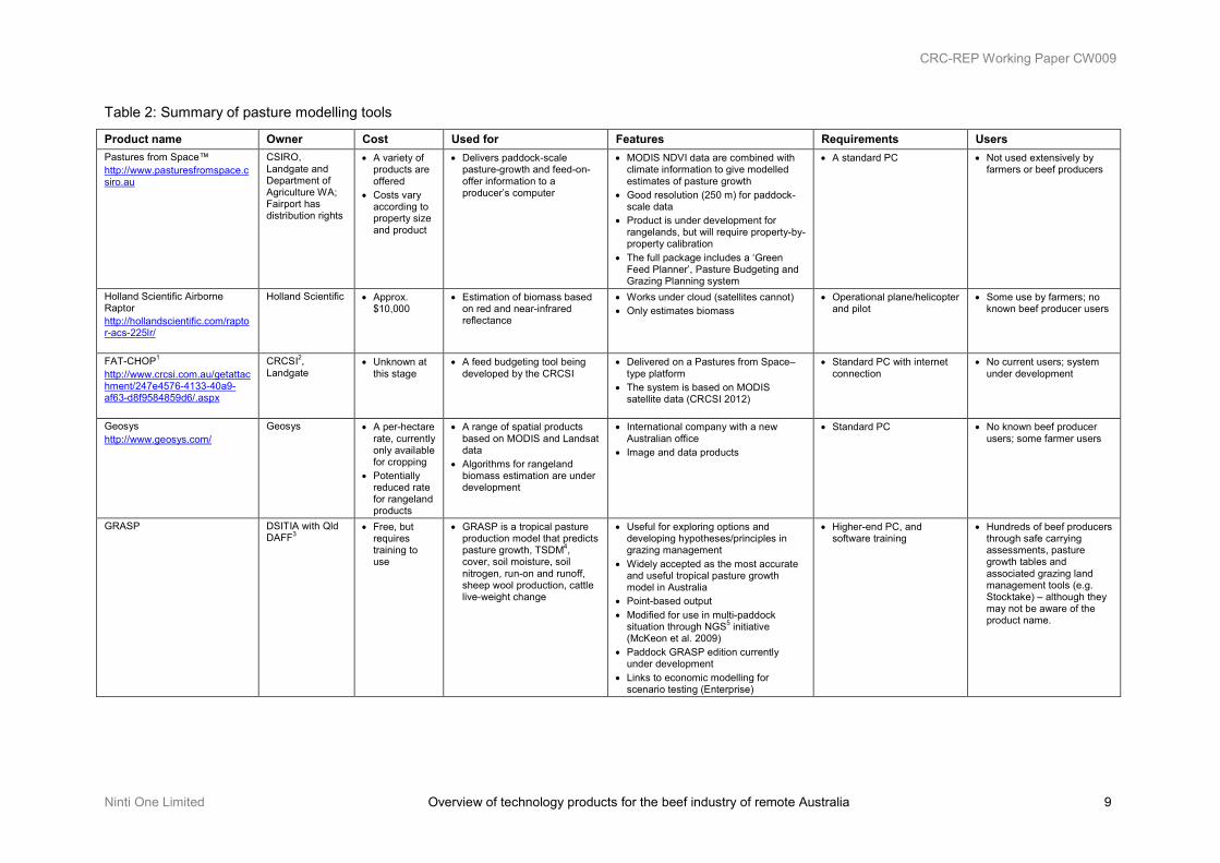
3.1.2 Pasture modelling Modelling of pasture offers both researchers and beef producers the ability to determine the effects of different climatic conditions, locations, land types and management decisions without the need to run long-term (> 30 years) and expensive research trials (Scanlan et al. 2011). In this chapter eight tools are reviewed that could be or are used by beef producers today to improve their ability to understand and manage their pastures.
Four of the eight products described in this section are either complete examples or components of commercially focused pasture budgeting tools. Pastures from Space, the Holland Scientific Airborne Raptor, FAT-CHOP and Geosys products all use remotely sensed data to assess pasture. The source of these data varies between the products (including both satellite and aerial vehicle), but each product attempts to use these remotely sensed data to model pasture availability for the land manager. More products may become available in the future as the technologies evolve and demand increases.
GRASP and AussieGRASS are two good examples of government agency–built modelling tools. Though they operate at different spatial scales, both have undergone years of iterative development by multiple agencies. They are capable of modelling multiple aspects of the grazing system and are integrated with a broad range of rangeland management tools and activities. For a large part of Australia, and certainly for Queensland, these tools have formed the core of the pasture modelling toolbox for some years.
Finally, FORAGE and Spider Mapping are good examples of the tools that could and should sit at either end of the modelling process. Spider mapping is a methodology for validating pasture models, and was used to inform and validate the AussieGRASS model from data collected at 600,000 sites, mainly from northern Australia (Hassett et al. 2000). FORAGE, on the other hand, is a tool for delivering ‘completed’ model outputs. Its rainfall and pasture reports provide simple location-specific reports of modelled historical rainfall, pasture growth and biomass, and ground cover.
CRC-REP Working Paper CW009
Ninti One Limited Overview of technology products for the beef industry of remote Australia 9
Table 2: Summary of pasture modelling tools
Product name Owner Cost Used for Features Requirements Users Pastures from Space™ http://www.pasturesfromspace.csiro.au
CSIRO, Landgate and Department of Agriculture WA; Fairport has distribution rights
• A variety of products are offered
• Costs vary according to property size and product
• Delivers paddock-scale pasture-growth and feed-on-offer information to a producer’s computer
• MODIS NDVI data are combined with climate information to give modelled estimates of pasture growth
• Good resolution (250 m) for paddock-scale data
• Product is under development for rangelands, but will require property-by-property calibration
• The full package includes a ‘Green Feed Planner’, Pasture Budgeting and Grazing Planning system
• A standard PC • Not used extensively by farmers or beef producers
Holland Scientific Airborne Raptor http://hollandscientific.com/raptor-acs-225lr/
Holland Scientific
• Approx. $10,000
• Estimation of biomass based on red and near-infrared reflectance
• Works under cloud (satellites cannot) • Only estimates biomass
• Operational plane/helicopter and pilot
• Some use by farmers; no known beef producer users
FAT-CHOP1 http://www.crcsi.com.au/getattachment/247e4576-4133-40a9-af63-d8f9584859d6/.aspx
CRCSI2, Landgate
• Unknown at this stage
• A feed budgeting tool being developed by the CRCSI
• Delivered on a Pastures from Space–type platform
• The system is based on MODIS satellite data (CRCSI 2012)
• Standard PC with internet connection
• No current users; system under development
Geosys http://www.geosys.com/
Geosys
• A per-hectare rate, currently only available for cropping
• Potentially reduced rate for rangeland products
• A range of spatial products based on MODIS and Landsat data
• Algorithms for rangeland biomass estimation are under development
• International company with a new Australian office
• Image and data products
• Standard PC • No known beef producer users; some farmer users
GRASP
DSITIA with Qld DAFF3
• Free, but requires training to use
• GRASP is a tropical pasture production model that predicts pasture growth, TSDM4, cover, soil moisture, soil nitrogen, run-on and runoff, sheep wool production, cattle live-weight change
• Useful for exploring options and developing hypotheses/principles in grazing management
• Widely accepted as the most accurate and useful tropical pasture growth model in Australia
• Point-based output • Modified for use in multi-paddock
situation through NGS5 initiative (McKeon et al. 2009)
• Paddock GRASP edition currently under development
• Links to economic modelling for scenario testing (Enterprise)
• Higher-end PC, and software training
• Hundreds of beef producers through safe carrying assessments, pasture growth tables and associated grazing land management tools (e.g. Stocktake) – although they may not be aware of the product name.
CRC-REP Working Paper CW009
10 Overview of technology products for the beef industry of remote Australia Ninti One Limited
Product name Owner Cost Used for Features Requirements Users AussieGRASS http://www.longpaddock.qld.gov.au/about/researchprojects/aussiegrass/project.html
DSITIA, but developed collaboratively with multiple federal and state agencies
• Free; password required for some products
• Simulating the hydrology and dry matter flow of pasture communities at a daily time step. Information layers of daily climate data, soil attributes (e.g. plant-available water range), tree cover, pasture community, and densities of grazing animals (i.e. domestic livestock, feral and native herbivores) (Carter et al. 2000)
• Outputs available through Longpaddock website
• Seasonal rainfall explains only 40% of the variation in seasonal pasture growth; models of soil water and pasture growth explain 50–70% of observed variation
• Incorporates NOAA validation data
• Standard PC and internet connection to Longpaddock website to view outputs
• Super computer required to emulate calculations
• Some beef producers directly use the Longpaddock website outputs
• Indirect use through drought applications (exceptional circumstances)
FORAGE rainfall and pasture report http://www.longpaddock.qld.gov.au/forage/index.html
DSITIA • Free • Location-specific reports of pasture growth, TSDM4 and cover via online order (Queensland Government 2012)
• Useful for highlighting broad fluctuations in climatic/pastoral cycles
• Reports are emailed on request as PDF documents
• Data available in monthly timesteps
• Standard PC, internet connection, email service
• Some agency users (e.g. Queensland Delbessie leasehold review program)
• Current rebuild of FORAGE should see higher profile and wider use
Spider Mapping
Public domain
• Expensive; major costs are field work (time and transport for adequately qualified personnel)
• Additional costs for analysing spatial data and processing any field samples
• Methodology for collecting broadscale (generally regional) pasture information from a moving vehicle (Hassett et al. 2000)
• Data collected at regular intervals and entered in a GPS-enabled database
• Regular stops are made to calibrate the observers
• Flexible methodology in terms of parameters recorded
• Some potential to adapt aspects of the method at property scale
• Data can be stratified in relation to landscape elements (e.g. land types)
• Laptop PC / tablet, GPS-enabled database software such as ArcPAD for data collection
• GIS software for data analysis
• A small number of beef producers use elements of the method for feed budgeting, but full examples of the system are only used currently by state agencies
1 Forage Assessment Tool Calculating Head on Pasture
2 CRC for Spatial Information
3 Department of Agriculture, Fisheries and Forestry
4 Total Standing Dry Matter
5 Northern Grazing Systems

CRC-REP Working Paper CW009
Ninti One Limited Overview of technology products for the beef industry of remote Australia 11
3.1.3 Mapping programs Primary producers know the value of a good map, whether it is drawn in the mud or an aerial photograph of their property. With the advancements in technology over the past 20 years, primary producers no longer need to go to their local government department for a complete property map; they can now develop and maintain their own. The Precision Pastoral Management Tools project research team has reviewed 12 mapping programs applicable to beef producers of remote Australia.
Two of the most advanced mapping programs include ArcGIS and Manifold GIS. These two programs are used by cartographers the world over and are their preferred options due to the technical detail available. These products are not generally used by beef producers but could be, with suitable training and support. One of the key features of ArcGIS is the ability to join two polygon boundaries – which may be drawn for paddocks – together without any gaps and thus allow accurate polygon area and distance calculations.
The next category of mapping programs includes those designed specifically for primary producers. AgDat, FarmKeeper, PASource and View are four programs with key features specifically targeting primary producers. AgDat is able to link with a Taggle System (satellite tracking of individual animals via a GPS located within an eartag) to show the location of remotely detected cattle on a property map. The Taggle System is currently in development phase and will be available to Australian beef producers in the future. FarmKeeper’s key feature is its feed budgeting tool designed for farmers who run an intensive cropping and grazing enterprise. It is a popular mapping program in New Zealand. PASource is also a free mapping program for Australian farmers who use precision agriculture products. One of PASource’s key features is that it is based on a cloud system, allowing the user to log in to their account from any location and view their property map and data. View is also a free mapping program that can link with a farmer’s precision technology products such as tractor guidance systems. For enhanced mapping functionality, farmers can upgrade from View to Farm Works™ Mapping.
The more general mapping programs for primary producers are gpMapper and Phoenix Mapping. gpMapper is one of the oldest and most popular mapping programs used by farmers, graziers and horticulturalists. It can be linked with other modules suited to primary production. Phoenix mapping is similar to gpMapper in that additional modules can be incorporated such as Financial, Budgets and Grazing. The features of Phoenix Mapping include being able to snap paddock boundaries together and its ability to store unlimited notes and images to a GPS point. Queensland’s Agforce Project’s Mapping workshops currently use Phoenix Mapping but in the past have used FarmKeeper.
There are a few mapping programs that beef producers can use at no cost. These include Google Earth and Maps, iFarm Mapping and the previously mentioned View and PASource. Google Earth and Google Maps allow producers to develop a basic property map with a Landsat image underlying it, and this can be shared easily. iFarm Mapping is a free mapping program customised to meet the needs of farmers developing maps for their own farms. The program can also be linked to other eAgribusiness programs for stock management and record keeping.
The mapping programs available for beef producers in remote Australia range from the simple to the highly technical and at a cost from nothing to over a thousand dollars per year. Which program beef producers prefer to use depends on what their purpose is and the level of detail they require. The distinct advantage in this technology is that beef producers are no longer reliant on someone else to develop their own maps; they can do this for themselves and update the maps as often as required.

CRC-REP Working Paper CW009
12 Overview of technology products for the beef industry of remote Australia Ninti One Limited
Table 3: Summary of mapping programs
Product name Owner Cost Used for Features Requirements Users AgDat http://www.agtrix.com/products-agdat
Agtrix • Approximately $200/year for single user but different price structure for organisations
• Cloud-based Farm GIS and reporting
• Integrates with Taggle data • Standard PC • Farmers, predominantly sugar cane
ArcGIS (ArcMap) http://www.esri.com/software/arcgis
ESRI • $1500 (basic single user license)
• Creating and maintaining property maps
• Snap to vertex to ensure no gaps between polygons
• Measures areas and distances in a range of units
• High level of precision
• Standard PC with a minimum 560MB of memory
• Cartographers
FarmKeeper http://www.farmkeeper.com/
Livestock Improvement Australia
• $550 per single user licence
• Mapping • Infrastructure planning • Feed budgeting exercises • Recording of farm activities
• Feed budgeting tool • Can calculate distances and areas
• Standard PC • Australian and New Zealand farmers
Google Earth http://www.google.com/earth/index.html
Google Inc.
• Google Earth is free
• Google Earth Pro costs $400 annual subscription
• Maps the Earth by the superimposition of satellite imagery (Landsat), aerial photography and GIS onto a 3D globe
• Useful for multiple mapping tasks
• Pro version has higher GIS capabilities • Simple/intuitive presentation of complex
datasets • Free access to a wide range of data
• Runs on standard PC
• Requires open broadband connection
• Used widely in general community, some use by beef producers
Google Maps http://maps.google.com.au/
Google Inc. • Free • Creating basic maps • Route planning • Locating businesses
• Free • Easy to collaborate and share maps • Maps can be made public or private • Basic polygons are easy to draw • Can calculate distances
• Standard PC with modern browser and reasonable internet connection
• People from around the world
gpMapper http://www.fairport.com.au/gpmapper/
Fairport • $550 per single user licence
• Create a property map • Calculate land areas of a
paddock • Measure distances for
fencelines or pipelines
• Moderately easy to use (Fitzpatrick & Neale 2008)
• Can link to farm record keeping for grazing, cropping or horticultural enterprises
• Can calculate areas and distances • Can link to some GPS products
• Standard PC • Australian farmers, graziers and horticulturalists
iFarm Mapping http://www.eagri.com.au/services/free-mapping.htm
eAgribusiness • Free ($20 for postage)
• Creating and editing a property map
• Preparing a property plan
• Free • Can link to cashbook, record keeping and
stock movements • Can calculate distances and areas
• Standard PC • Australian farmers and graziers
Manifold GIS http://www.manifold.net/
Manifold Systems
• $245–$945 per single user licence
• Create and edit a property map • Combination of mapping, CAD, DBMS and image processing
• Can be imported from or exported to ArcMap
• Microsoft integrated • Can calculate areas and distances
• Standard PC and internet connection required
• International users • Cartographers

CRC-REP Working Paper CW009
Ninti One Limited Overview of technology products for the beef industry of remote Australia 13
Product name Owner Cost Used for Features Requirements Users Ozi Explorer http://www.oziexplorer.com/
Mr D Newman • $130 per single user licence
• Route planning with GPS waypoints
• Plotting of routes or points on a map
• Reads and writes ArcView shape files • Reads MapInfo .mif files and ArcInfo .e00
files
• Standard PC • Recreational users e.g. Fishers, bushwalkers or 4WDers
• WA pastoralists • Potentially rural fire fighters,
search and rescue and remote workers
PASource http://www.pasource.com.au/
PASource • Free for limited services
• Create and edit property maps • Enables production of shape files such as paddocks
• Can integrate with precision agriculture data such as yield, elevation, satellite and gamma radiometric
• Can access property maps from any computer with an internet connection
• Standard PC • Australian farmers and agronomists
Phoenix Mapping http://www.agdata.com.au/PhoenixProduction/PhoenixMapping.html
AgData • $596 per single user licence
• Create and edit property maps • Develop property plans • Record keeping
• Can calculate areas and distances • Snap to vertex to ensure no gaps between
polygons • Calculate a grazing radius within a paddock • Can store unlimited notes and images to a
GPS point
• Standard PC • Australian graziers and farmers
View http://www.farmworks.com/products/View
Farm Works™ • Free, upgrade to Farm Works™ Mapping for US$750.00 per single user licence
• Read and write job data to popular precision farming devices
• Free • Able to use Google Maps as a raster file • Links to multiple precision agriculture
products
• Standard PC • North American and Australian farmers

CRC-REP Working Paper CW009
14 Overview of technology products for the beef industry of remote Australia Ninti One Limited
3.1.4 Management software One of the most critical challenges a manager faces is determining how many stock can be carried safely for the production cycle to achieve production, business and land condition goals. Having too few stock may see the manager not maximise their production or business goals; too many stock may see the manager overgraze the land and not meet production and business goals. The products reviewed in this section (Table 4) are designed to help beef producers make well-informed stocking rate decisions to minimise the grazing impact on the landscape while also meeting their production and business goals.
For beef producers in remote Australia there are two software programs that can assist with monitoring and managing their pastures and benchmarking their grazing land’s condition over many years. These programs provide quantifiable data that can be used for immediate and long-term management decisions on stocking rates. In this chapter we also discuss two additional software programs available to dairy producers in New Zealand to see how an intensified industry manages these data.
Stocktake is a program developed specifically for northern beef producers and it can be used to feed budget on a paddock-by-paddock basis. It is supported in Queensland, the Northern Territory and northern Western Australia by calibrated annual feed production data for different lands types using the pasture growth model GRASP. Stocktake is supported by a one-day training program to equip the manager in use of the software and the methods for its application on a station.
Stocktake is also designed to train a manager to assess land condition and understand the production losses from poor land condition and the production gains that are possible from improving land condition, that is, improving the capacity of the land to grow pasture in response to rainfall. The program is now under development to become an application on a smartphone. A recently completed MLA project analysed the viability of such an application for northern beef producers and recommended that the application be developed.
VegMachine is designed specifically to enable beef producers to see the changes in ground cover over time. The key feature of this software is its ability to quantifiably measure changes in ground cover, thus reflecting the condition of the grazing land and whether, over the medium to long term (ten to thirty years), it is improving, declining or remaining unchanged. It has proven useful for advisors to engage with beef producers in discussing management practices that can either enhance or reduce ground cover.
Pasture management software to assist with feed budgeting is frequently designed for the intensive livestock industries, particularly dairying, where daily management of feed quantity and quality to milking cows is directly related to milk yield and business profit. Below we review two New Zealand feed budgeting programs for dairies, namely FeedFlo and FeedPlan Pro. These are not suitable for extensive beef operations but a short tour around a free trial program demonstrates how feed budgeting can be integrated with modelled and observed estimates of available dry standing matter in a user friendly manner for dairy farm managers.

CRC-REP Working Paper CW009
Ninti One Limited Overview of technology products for the beef industry of remote Australia 15
Table 4: Summary of pasture management software
Product name Owner Cost Used for Features Needs Used by Stocktake http://futurebeef.com.au/resources/workshops/sustainable-grazing-workshops/stocktake-balancing-supply-and-demand/
Qld DAFF • Cost of attending 1-day workshop (~$330)
• Determine short-term feed budgets
• Assess land condition • Asses long-term carrying
capacity
• Simple, systematic method to assess land condition and impact on carrying capacity
• Built on Microsoft Access • Automated Animal Equivalents and Dry Sheep
Equivalents calculations • Accommodates sustainable utilisation rates • Database to store and report on short- and long-term
carrying capacity, land condition, photos, etc • Includes pasture parameters such as detachment and
residual biomass • Incorporates pasture growth prediction using the
GRASP model but accepts manual inputs of feed data
• Standard PC • Digital camera • Skills in estimating
pasture yields • Attendance at the 1-
day workshop • Requires regular use
of software
• Northern beef producers and their advisors
Stocktake iPhone app MLA and Qld DAFF
• Preliminary investigation completed; TBA on further development
• Using Stocktake in the paddock (see above)
• Effectively a hand-held computer incorporating a camera and GPS (Hamilton & Banney 2011)
• Enables easier implementation of land condition assessment and feed budgeting using Stocktake
• iPhone • Aimed for northern Australia pastoralists
VegMachine http://futurebeef.com.au/resources/tools/vegmachine/
CSIRO Australia
• Free for beef advisors and producers but requires attendance at a training workshop
• Monitor change in ground cover over time
• Combined with other information, provides indicator of landscape health
• Plan infrastructure developments such as new watering points
• Demonstrate responsible stewardship of the land resource
• Landsat TM images from 1983 in some areas and later in others
• Provides annual image of cover level, type and structure
• Enables analysis of trends and comparisons of paddocks with district averages
• Due to variance, best suited for detecting changes in large-scale landscape over longer periods of time (Peel et al. 2006)
• Standard PC • Requires one day of
training • Requires annual
updates with custom-built datasets
• Mostly advisors to northern beef producers
FeedFlo http://www.feedflo.co.nz/feedflo.aspx/
Agriculture Software Ltd (NZ)
• $330 for single user licence
• Dairy farm feed budgeting tool
• Good visual displays of paddock supply • Calculating supplement requirements • Pasture cover entered as Rising Plate Meter units or kg
DM/ha • Accesses NZ regional pasture growth prediction
models • Monitors farm pasture cover • Plans rotational grazing • Provides daily planner for mob allocation to paddocks
• Standard PC • NZ dairy farmers
FeedPlan Pro http://www.feedplan.co.nz/feedplan%20pro.aspx/
Dexcel and Agricultural software Ltd
• NZ $250 download • NZ $280 • CD • for single user
licence
• Planning whole farm feed supply and demand
• Calculates feed supply and demand for 10- or 15-day periods for 3 months or 1-month periods for a 12-month budget
• Accesses regional growth models which can be modified for local conditions
• Large number of supplementary feed options and their Metabolisable Energy
• Good array of reports
• Standard PC • NZ dairy farmers

CRC-REP Working Paper CW009
16 Overview of technology products for the beef industry of remote Australia Ninti One Limited
3.2 Cattle technology products This chapter is divided into four subsections dependent on the product’s purpose and operation. The four subsections cover remote monitoring, herd modelling, remote management and livestock recording software. The remote monitoring section describes technology products that are able to monitor cattle performance or location with little or no human labour inputs. In the herd modelling section two products are described that are able to model the economic implications of herd changes due to expected management decisions. In the third section, remote management, two technology products are described that aim to manage cattle remotely without the need for humans to be present. In the final section, livestock recording software, six software products are described that record and manage data that are kept for cattle management. The products described in this chapter reflect the innovative thinking occurring in the beef industry to overcome challenges of increasing costs, market instability and isolation.
3.2.1 Remote monitoring The beef industry is increasingly being driven to adopt remote monitoring of watering points and livestock. Beef producers are under pressure with an increase in the costs of fuel, vehicles and labour as well as decreasing labour availability and are searching for solutions that can relieve these pressures. Following is a description of the available and developing technologies that can remotely monitor water availability and livestock.
Observant provides telemetry or 3G-enabled remote monitoring products that can have a significant impact on direct costs and costs of labour and management for an extensive pastoral station. Observant’s solar-powered water point monitoring technology has been shown to have pay-back periods of one to two years (James & Bubb 2008, Zeller 2011). The ability to remotely monitor the waters on a station not only reduces vehicle and fuel costs but frees management to focus on other important decisions. Incorporating camera technology allows photographs of troughs or livestock to be taken at pre-determined times of the day and presented on a webpage for the manager’s inspection at the office.
The Remote Livestock Management System (RLMS), currently at the prototype stage of development, incorporates a combination of hardware and software providing the capacity to automatically identify, weigh and draft individual animals within a cattle herd without the need for labour inputs or human presence. The RLMS can also transmit the data from a remote location to a cloud-based network for processing and then back for display on a webpage in the manager’s office. The results of Near Infrared Reflective Spectroscopy (NIRS) faecal analyses can also be displayed.
Regular weight records depend on the presence of either water or supplementary feed to attract the cattle to a central point so that livestock carrying a Radio Frequency Identification Device (RFID) tag can pass through the RLMS. Weights are not determined in a single pass; after a number of passes are recorded, an accurate weight is determined. Calving dates can be determined based on the weight changes of the cow and if the calf has an RFID tag, calves can be matched to their mothers, subsequently providing calf birth date. Parameters for drafting can be entered into the system and the system can draft animals with an accuracy of 96% per pass. An extra addition can be made to the unit so it collects data on animal traits such as condition score, frame score, hip height, hip widths and stifle widths, once animals are fully grown.
The grazing pressure of non-domestic animals often reduces livestock productivity and contributes to operating and labour costs through the necessary control measures. Machine Vision remains in the research phase but when incorporated in an auto-drafting facility, it could offer the possibility of identifying

CRC-REP Working Paper CW009
Ninti One Limited Overview of technology products for the beef industry of remote Australia 17
unwanted animals as they pass the system at a water point and then drafting them into secure holding yards for removal.
Managing the deleterious impacts of patch grazing is a major challenge for the beef industry, both in terms of optimising pasture utilisation and for minimising the degradation occurring on heavily grazed patches. GPS collars communicating with satellites, or Taggle Tags on cattle communicating with telemetry base towers and a base station enable the grazing patterns of livestock to be defined precisely. Once defined, a range of strategies can then be implemented to ameliorate the effects of patch grazing. These can include placement of supplements, burning strategies and location of fences. In addition, being able to remotely locate cattle has the advantage of reducing costs of mustering.
Military investment has accelerated the development of Unmanned Aviation Vehicles (UAV), which have the potential to further improve efficiency and cost:price ratios of the extensive pastoral industry. UAVs have been tested on stations in the Julia Creek region of Queensland for identification and treatment with granular herbicide of weeds such as parkinsonia (Bryson & Sukkarieh 2011). UAVs have been used in Africa for locating animals using infrared technology. Currently high resolution satellite imagery is considered cheaper than using UAVs to obtain imagery for assessing biomass and fodder quantity and quality. Nonetheless, cost effective uses for UAVs in the future are likely to be found for remote pastoral stations as the technology develops and their costs reduce.
Pregnancy testing can be costly in remote pastoral stations due to the need to ‘fly in’ a qualified technician or to train staff to do the diagnosis themselves. The ePreg is a non-invasive pregnancy testing tool that is still in the development phase but it is expected to be released in late 2012. The ePreg is placed against the flank of the cow and diagnosis of pregnancy occurs once the unit is able to detect the foetal heartbeat via soundwaves. The per head costs of testing may not be reduced compared to manual pregnancy testing but will negate the reliance on a qualified pregnancy technician.
The arrival of an iPhone application specifically designed for livestock producers signals the arrival of the latest revolution in communication technology for the livestock industry. The iHerd application enables an iPhone to count animals running past, record numbers, treatments, paddock data and almost everything – as well as more – that was recorded (or not) in the trusty notebook in the top pocket. The image of a manager entering livestock counts and other information into an iPhone instead of the tattered stock book surely is a harbinger of revolutionary times of a once low technology industry.

CRC-REP Working Paper CW009
18 Overview of technology products for the beef industry of remote Australia Ninti One Limited
Table 5: Summary of animal remote monitoring
Product name Owner Cost Used for Features Requirements Users Remote Livestock Monitoring System (Walk Over Weighing)
Precision Pastoral Pty Ltd
• Currently not commercially available
• Remotely identifying, weighing, photographing, recording data about and automatically drafting cattle and transmitting data via telemetry to a server and then to the management’s computer (James 2007)
• Remotely drafting animals for moving or selective supplementation
• Identifying low performing breeders (Driver 2007)
• Telemetry communication system • Ability to collect livestock data
consistently, accurately and regularly in remote locations
• Drafting at 96% accuracy • Weighing to 98% accuracy of manual
yard weighing
• Regular maintenance • Data management
• Potential users are the extensive pastoral businesses of the Australian cattle industry
Machine Vision Technology (MVT) http://www.uq.edu.au/research/index.html?page=90755&pid=0
University of Queensland
• Not commercially available
• Drafting off non-domestic animals coming to a watering point
• Machine Vision Technology combined with an auto-drafter
• Cost effective and humane control of non-domestic grazers
• Holding yards to secure the non-domestic animals
• Research only
GPS Collars Various, including Telemetry Solutions, Sirtrack, Titley Scientific, Televilt, etc
• Store-on-board systems, minimum $1,000 per unit
• Real-time-telemetry systems, minimum $2,500 per unit
• Locating animals in remote areas • Understanding spatial grazing
patterns to reduce effects of patch grazing and to improve safe utilisation rates
• Identifying areas for burning and locations of supplements to spread grazing pressure
• Accuracy of ±5 m
• Satellite uplink • GIS data processing
• Used mostly for research purposes
Real-time Ear Tag Spatial Monitoring Devices http://www.taggle.com.au/
Taggle Systems Pty Ltd
• Not commercially available
• Estimated costs: $20 per tag; $7,000 per tower and minimum of three towers
• Locating animals in remote locations
• Understand spatial grazing patterns to reduce effects of patch grazing and to improve safe utilisation rates
• Identifying areas for burning and locations of supplements to spread grazing pressure
• Uses Radio Beacon Triangulation with Telemetry
• Real-time location of animals • Accuracy of 50–100 m • Data protected from outside viewing • Options for neighbours sharing
towers on boundaries
• Minimum of three towers within 30 km depending on terrain
• Server to process data and distribute to device owner
• Potentially livestock producers in a range of situations, including remote pastoral business
Unmanned Aviation Vehicles http://www.mla.com.au/Research-and-development/Final-report-details?projectid=15146
Various: Cyber-technology (Perth based) V-TOL Aerospace P/L (Brisbane based)
• Various, e.g. CyberEyell
• Approx. $40,000 for up-front purchases plus $107/day (fuel and maintenance) (Bryson & Sukkarieh 2011)
• Locating animals and weeds and applying granular herbicides
• Obtaining images of landscape for monitoring land and assessing feed production
• Currently used in research activities
• Rapid development in the technology • Incorporates development in imagery
technology • Low-cost structure relative to
manned aircraft
• Requires CASA licence to operate outside the operator’s sight
• Accredited operator and field staff to download and process data
• Fixed-wing UAV platform • UAV sensor payload • UAV ground station • Equipment • data processing facilities
• Military, researchers and horticulturalists for spraying
• Potential uses for remote pastoralists with future developments

CRC-REP Working Paper CW009
Ninti One Limited Overview of technology products for the beef industry of remote Australia 19
Product name Owner Cost Used for Features Requirements Users ePreg Prototype http://www.heardsystems.com.au/
HEARD Systems and MLA
• Not commercially available until late 2012
• Estimated purchase cost $15,000 or a lease rate competitive with manual pregnancy testing
• Non-invasive pregnancy diagnosis • Sensors to detect foetal heart beat • Matches diagnosis with electronic
eartag
• Secure cattle crush with access to the near side of the animal
• Lubricant for application to animal’s hide
• Sensor replacement after 20,000 animals
• Aimed at cattle producers
Observant Telemetry http://observant.com.au/
Observant Pty Ltd
• Approx. costs: • Telemetry unit
$2,000 • Start/stop unit $1,200 • Repeater unit $2,000 • Base station unit and
software $1,500 • Annual service
charge of $25/month plus $5/month/water
• Remotely monitor stock water points at low cost
• Control motors • Improve security of remote water
supplies and infrastructure • Photograph at pre-determined
intervals • Transmit data to and from auto
weighing machines providing remote management opportunities
• Opportunities for substantial reduction in labour and operating costs for remote pastoral business
• Provides > 50% ROI and payback period of between 1 and 1.7 years when used for monitoring stock waters (Zeller 2011)
• Can be integrated with 3G systems • Can be accessed from any internet
connection • Supported by small but reputable
firm
• Base station • Telemetry unit • Network of towers to
transmit signals to and from base station and cloud-based server
• Extensive pastoral business and those needing remote management facilities for infrastructure
iHerd iPhone App http://iherd.com.au/
Calliope Cattle Company
• Free • Designed to replace traditional stock recording book
• One-entry stock records of numbers, paddocks, treatments
• Improved communications with off-station owners and managers
• Labour saving device (claims of 12 hours per month)
• Ability to count cattle as they pass
• iPhone or iPad with iOS4 or later
• Cattle producers

CRC-REP Working Paper CW009
20 Overview of technology products for the beef industry of remote Australia Ninti One Limited
3.2.2 Herd Modelling Herd modelling programs enable livestock producers and their advisors to conduct desktop investigations of a range of herd and land management options. These economic modelling exercises can be useful from a strategic planning perspective when determining long-term herd and grazing management practices; they are also useful for short-term planning investigating the economic and herd structural implications of different management tactics for current seasonal or livestock market scenarios.
The two herd modelling programs examined in this report can be used to look at the impact of different herd and grazing management practices on the profitability of a livestock business. ‘Breedcow and Dynama’ is a herd-based model used by advisors and pastoralists familiar with spreadsheets and computers generally. ENTERPRISE is a sophisticated economic herd model that has been modified to incorporate a range of simulated grazing land management practices. It is not designed for use by producers. The Breedcow and Dynama modelling tool can be used by cattle producers irrespective of region, whereas ENTERPRISE is designed for use in northern Australia.
Breedcow and Dynama is a suite of 10 herd economic models programs that model the profitability of a breeding herd, enabling comparisons of alternative management options. The profitability on the beef herd and associated cashflow of the business can be projected out for period of up to 10 years.
The first model in the suit is ‘Breedcow’. This allows the impact of management and husbandry decisions to be compared by the gross margin of a static breeding herd. For each husbandry or management variation, assumptions on the impact on herd productivity are manually put into the model through the costs and turnoff numbers. This will show a difference in the calculated herd gross margin. The ‘AE Calc’ module supports the calculation of herd size, structure and growth, while the ‘Prices’ module supports the estimates of animal growth rates, turnoff and prices received.
The Breedcow and Dynama package is also capable of comparing the impact of management or husbandry decisions on the cash flow of a business over a 5- or 10-year period. ‘Dynama’ is the module to use for this analysis, whereas the ‘Investans’ module will compare return on investment over a 10-year period.
A difficulty with Breedcow and Dynama is that the spreadsheet program used to develop the model is very different from the Microsoft Office Excel program used by most producers. However, once a user understands how to navigate through the modules, it is relatively straightforward to use. The accuracy of the output, as always, will be determined by the accuracy of inputs, especially the estimated growth of the animals, which is predicted through the AE Calc module. Hence accuracy of producers’ livestock records is important.
The Breedcow and Dynama program is now being converted to a Windows platform and a 64-bit operating system, which will make it more user friendly for cattle producers.
ENTERPRISE is a herd economic model that has been modified to allow a wide range of grazing land management practices to be simulated. It is a complex program not designed to be used by pastoralists. Under the command of a skilled operator, the outputs of the program can be of great use in helping a pastoralist understand the impact of different management tactics and strategies.
A key strength of ENTERPRISE is its ability to link with GRASP as a dynamic model that includes annual stocking rates and associated annual live-weight changes based on rainfall, pasture growth and land condition. It is also a multi-paddock model capable of simulating productivity and returns at the paddock level. These can be imported for a range of management scenarios such as stocking rate management, wet season spelling and prescribed burning scenarios.

CRC-REP Working Paper CW009
Ninti One Limited Overview of technology products for the beef industry of remote Australia 21
Table 6: Summary of herd modelling
Product name Owner Cost Used for Features Needs Used by BreedcowDynama http://futurebeef.com.au/topics/business-management/breedcow-and-dynama-free-off-the-web/
Qld DAFF • Free • Two -day training
program approx. $1,000
• To plan, evaluate and improve the profitability of cattle enterprises by the economic modelling of a range of alternative management practices
• Enable gross margin comparisons and impact on herd structures of management decisions to be compared when projected out 10 years
• Enable comparisons of steady-state herd gross margin for alternative management strategies
• Currently being converted to a more user friendly Windows platform incorporating improvements as a result of producer feedback
• Standard computer • New model being
developed is designed for a 64-bit processor
• Two-day training workshop
• Consultants • Beef producers
ENTERPRISE
CSIRO • Free • Researching the impacts of a range of herd and grazing management scenarios at whole-station and paddock scale
• Powerful scenario testing tool enabling detailed economic investigations of multiple management scenarios
• Gross margins calculated on predicted growth rates, which are modelled on pasture growth (Macleod & Ash 2001)
• High powered computer
• Large input dataset required
• Requires skilled operator
• Researchers
CRC-REP Working Paper CW009
22 Overview of technology products for the beef industry of remote Australia Ninti One Limited
3.2.3 Remote management New technology developed in other industries has enabled the beef industry to investigate ways that cattle can be remotely managed to either decrease costs or increase production. There are two systems in development that will allow producers to undertake management actions of their cattle without requiring either labour or extensive infrastructure. These two systems are the automatic drafting component of the RLMS and virtual fencing of cattle in a paddock.
The auto-drafter of the RLMS is capable of identifying and drafting individual animals in an RFID-tagged cattle herd with no physical labour inputs or human presence required. This solar-powered auto-drafting system uses telemetry to transmit data between a remote location and the office of a manager. It takes advantage of water as the primary attractant for livestock by using an obligatory walk over weighing facility at water points.
The auto-drafting facility can be used for cost-effectively separating animals for sale to specific markets, moving animals due to fodder considerations, for weaning, for individual supplementation or for culling due to poor growth rates or poor reproduction performances. These capabilities of the RLMS auto-drafter have the potential to make significant reductions to the cost structure of a pastoral business and significant improvements to the overall herd productivity, mainly through improved breeder performance.
Virtual fencing has been under discussion in the pastoral industry for many years. It was almost forty years ago that Peck filed a patent targeting the domestic dog and cat market. Many different approaches have been researched around the world in attempts to develop the elusive virtual fence for livestock. Currently the USA research project addressing this challenge has ceased and in Australia, CSIRO is researching an animal-friendly virtual fencing system for cattle. The CSIRO research team has created a prototype system and has successfully demonstrated its use on a cattle herd. The prototype system works by individual cattle being collared with a GPS that transmits the animal’s position and provides cues by sound or stimuli via a mild electric shock to deter the cattle from entering an exclusion zone (Bishop-Hurley et al. 2011). Tests have shown that in less than one hour, cattle can learn to associate the sound signal from their collars with the virtual boundary and consequently move to avoid the virtual boundary. Before the prototype system can become a commercial reality, the main technological challenge of power consumption of the collar must be overcome.

CRC-REP Working Paper CW009
Ninti One Limited Overview of technology products for the beef industry of remote Australia 23
Table 7: Summary of remote management of cattle
Product name Owner Cost Used for Features Needs Used by Remote Livestock Monitoring System (Auto-drafter)
Precision Pastoral Pty Ltd
• Currently not commercially available
• Remotely identifying, weighing, photographing, recording data about and automatically drafting cattle and transmitting data via telemetry to a server and then to the management’s computer (James 2007)
• Remotely drafting animals for moving, weaning or selective supplementation
• Identifying low performing breeders
• Telemetry communication system • Ability to collect data consistently,
accurately and regularly in remote locations • Drafting at 96% accuracy • Weighing to 98% accuracy of manual yard
weighing
• Regular maintenance • Data management
• Potential users are beef producers from remote Australia
Virtual Fencing
CSIRO
• Still in development phase
• Containing livestock within a defined area
• Preventing livestock accessing defined areas, e.g. riparian area
• Moving livestock
• CSIRO team researching a prototype • Sound cue and mild electrical stimuli from
collars effectively divert cattle from virtual fence (Bishop-Hurley et al. 2011)
• Meets animal welfare standards
• Wireless sensor network
• Computer • Custom-equipped GPS
collars
• Currently under research and development

CRC-REP Working Paper CW009
24 Overview of technology products for the beef industry of remote Australia Ninti One Limited
3.2.4 Livestock management software The introduction of electronic identification devices (EID) and electronic scales has created opportunities to record livestock production data quickly and efficiently. Previously, all records were committed to paper and manually transferred to a computer. Although data can be recorded relatively easily nowadays, the real power of using the data in a computer program is to record information of large numbers of animals throughout their life and being able to recall the data easily for processing. The challenge is to record quality data that will assist beef producers improve the productivity of their herds.
Six livestock management software programs have been reviewed that beef producers could use to assist with management decisions.
When using livestock management programs, consideration must be given to four issues:
1. What data to capture? 2. How is data captured and transferred to computer program? 3. How will data be used? 4. What support equipment is required to capture and transfer data?
The weight of an animal is very simple to capture and record with modern electronic weighing equipment, and EIDs and tag readers eliminate the need to create manual records. The information can be transferred directly to the computer program from a data logger (using cable or Bluetooth connections) or uploaded from the data logger to computer using an Excel .csv file. In addition to body weight, there are other traits essential to livestock management that can be recorded, including pregnancy status, condition score, lactation and breeding history. Recording these data can be more time consuming. Similarly, recording subjective traits and treatments applied to animals while they are being processed can slow down the movement of cattle in the yards unless there is the capacity to record efficiently by the use of shortcut keys and good keyboards. This review did not investigate the speed of recording information.
The introduction of the National Livestock Identification System (NLIS) as a livestock traceability system requires animal movements (sales and transfers) between properties to be entered into a database. The information transferred is the property identification code (PIC), animal identification (EID) and the national vendor declaration (NVD). All the programs reviewed are capable of linking directly to the NLIS database, except Ranchmanager which is a USA-based program. The USA does not have an equivalent to the Australian NLIS. Basic programs, such as QA Logbook, also record weight of livestock, veterinary treatments and supplementary feeding. Being able to report this data is essential for meeting quality assurance accreditation schemes, which can be a requirement to access certain markets.
The more sophisticated programs are capable of recording the full life history of an animal, including breed, mating history, calves born, as well as recording growth history and carcass quality information. There is flexibility to create reports that allow information to be filtered to identify the most productive breeders. Where parentage can be identified, family trees can be recorded. Stockbook, Herdmaster, Stockman and Outcross all have these features as well as the capacity to operate auto-drafting gates.
Outcross provides a service for data collection through a suite of programs provided by Sapien technologies as well as the hire of equipment to capture the EID number.
Software manufacturers produce several models based on the size of the herd. Stud and commercial versions are both available. These management packages are driven by complex computer programs and generally require some training to learn how to use them efficiently. Software manufacturers provide this
CRC-REP Working Paper CW009
Ninti One Limited Overview of technology products for the beef industry of remote Australia 25
training at a cost and also provide a back-up service to assist producers, which may include program updates. Care needs to be taken when purchasing products to ensure the correct package is purchased to suit the user’s needs.
Capturing data in the yards comes with some risk, and this risk can be managed. The risk of lost data can be managed by using software packages that incorporate automatic back-up capacity. Back-up power supply and back-up hardware is often justified to avoid the risk of losing data due to power loss. These costs may seem expensive in some instances, but lost time due to breakdowns can be a critical issue when large numbers of livestock are being processed through yards.

CRC-REP Working Paper CW009
26 Overview of technology products for the beef industry of remote Australia Ninti One Limited
Table 8: Summary of livestock management software
Product name Owner Cost Used for Features Requirements Users Herdmaster http://saltbush.une.edu.au/products/herdmaster4
Saltbush Agricultural Software
• Year 1 $495 • (thereafter annual fee
$275)
• Livestock management records (Stud and commercial herd versions)
• Links to NLIS database • Unlimited herd size • Data can be uploaded or directly recorded in yard • Links to farm map for stocking rate calculation • Family tree and Estimated Breeding Values (EBV) • Several models available, depending on herd size • Ability to include photos of individual animals • Ability to synchronise program where data stored on several
machines • Option of HerdMASTER Pocket for handheld devices and
synchronisation facility
• Standard computer • Equipment to
record EID • Weighing
equipment • Connection
between computer and data logger
• Mobile device capable of running windows mobile 2003
• Farmers and beef producers
Stockbook http://www.practicalsystems.com.au/stockbook-1015.html
Practical Systems
• $2700 or $700 annual fee
• Livestock management records (Stud and commercial herd versions)
• Links to NLIS • Unlimited herd size • Data can be uploaded or directly recorded in yard • Family tree and EBV • Several models available, depending on herd size • Ability to include photos of individual animals • Ability to synchronise program where data stored on several
machines
• Standard computer • Equipment to
record EID • Weighing
equipment • Connection
between computer and data logger
• Farmers and beef producers
Ranchmanager http://www.lionedge.com/
Lion Edge Technologies
• $99 (US) per single user license
• Livestock records and management
• Can be linked to smartphone or tablet • Interaction between map and cattle in paddock • Ability to include photos of individual animals
• Standard computer • Equipment to
record EID • Weighing
equipment • Connection
between computer and data logger
• Farmers and beef producers
• (designed for USA market)
StockIT http://www.livestockexchange.com.au/products/software/livestock-exchange/stockit%E2%84%A2
Livestock Exchange
• $2,300 per single user license
• Livestock records and management
• Links to NLIS database • Unlimited herd size • Data can be uploaded or directly recorded in yard • Links to farm map for stocking rate calculation • Family tree and EBV • Several models available, depending on herd size • Ability to include photos of individual animals • Ability to synchronise program where data stored on several
machines
• Standard computer • Equipment to
record EID • Weighing
equipment • Connection
between computer and data logger
• Farmers and beef producers

CRC-REP Working Paper CW009
Ninti One Limited Overview of technology products for the beef industry of remote Australia 27
Product name Owner Cost Used for Features Requirements Users Outcross http://outcross.com.au/index.htm
Outcross Pty Ltd
• Technology can be rented and quotes are provided on request
• Data collection and recording service that utilises several programs provided by Sapien technologies
• Records almost any animal information required
• Links to NLIS database • Unlimited herd size • Data can be uploaded or directly recorded in yard • Links to farm map for stocking rate calculation • Family tree and EBV • Several models available, depending on herd size • Ability to include photos of individuals • Linkages to breed societies • Ability to synchronise program where data stored on several
machines
• Standard computer with internet access
• Beef producers
QA Logbook http://www.wilbase.com.au/logbook.htm
Wilbase • $550 per single user license
• Livestock records and management
• Records animal treatments • Capacity to link data to NLIS database
• Standard computer • Beef producers requiring quality assurance certification

CRC-REP Working Paper CW009
28 Overview of technology products for the beef industry of remote Australia Ninti One Limited
3.3 Other technology products
In addition to the already-described technology products that beef producers can use to either guide or undertake management actions on their property, some other products can also play a role in the management of beef operations in remote Australia. These include the Elders Weather website, remote still and video images and the 3G network.
Like other agricultural production systems in Australia, beef production is heavily influenced by the weather. Beef producers rely heavily on the latest weather forecasts for their region and source this information from the media, websites, their own networks and observations. The Elders Weather website is not the only website providing such information. The Bureau of Meteorology, Weatherzone and The Weather Channel also provide weather information. What is unique about the Elders Weather website is the manner in which the information is presented and its popularity among beef producers. The website provides all the relevant weather data for a beef producer on one page for their location. It answers the questions that a producer would want answered about the weather such as:
• What is the current temperature, humidity, wind speed and direction, and rainfall? • What is the 7-day forecast for my location (max and min temperature, chance of rain and likely
amount, UV index, frost risk, humidity, and wind speed and direction)? • What has been recent weather activity? • What are the weather averages, maximums and minimums for this time of year?
An important factor for the website and its users is that the amount of rain predicted also includes a likelihood figure expressed as a rainfall range with an attached probability, for example, 90% chance of 10–20 mm. This allows the users to understand how confident the weather models are for that rainfall event, which assists management decisions. The Elders Weather website does its own weather analysis but relies on Weatherzone to produce it. What Elders has done well is to customise the weather data to meet its users’ needs and expose more people to Elders and their services.
Remotely collected still images and video are not new technologies but their application in remote Australia has posed significant challenges. Beef producers have dreamed about being able to check specific locations such as cattle troughs, water tanks or pasture on their property without the need for travel. This image technology is commercially available but it is reliant on a telemetry system or a 3G network to transmit the image or video back to the home computer for viewing. While the installation of a telemetry system does come at a cost to the producer, this cost can be recovered through the savings in time, fuel and vehicle maintenance.
The 3G network is not widely available in remote Australia and is concentrated around regional centres and priority remote locations, such as mine sites. Those producers who live within reception of the 3G network are able to use their mobile telephones for phone calls, internet access, mobile video calls and television. In addition, due to the increased bandwidth of the 3G network, properties within range are able to avoid the cost of installing telemetry infrastructure and make use of the relatively low cost of the 3G network charges to transmit data from their remote monitoring systems for stock water and its associated infrastructure. Similarly, the 3G network can be used for data transmission associated with the Remote Livestock Management System described elsewhere in this review.

CRC-REP Working Paper CW009
Ninti One Limited Overview of technology products for the beef industry of remote Australia 29
Table 9: Summary of other technology products
Product name Owner Cost Used for Features Needs Used by Elders Weather http://www.eldersweather.com.au/
Elders and Weatherzone
• Free • Local and national weather updates and forecasts
• Weather is customised to the user’s nearest weather station
• The interface is simple, quick and provides all the information at a glance
• Provides a 7-day forecast, including likelihood and amount of rain
• Standard PC • Internet connection
• Australian primary producers
• General public living in regional communities
Remote still images and video http://live.usee.com/
http://observant.com.au/
http://www.precisionagriculture.com.au/remote-camera-systems.php
Multiple suppliers e.g. uSee, Observant and Precision Agriculture
• Recording devices range in price from $30 to $1,000
• Additional costs in transmitting the image via a telemetry system for still images and 3G for video
• Remote monitoring of specific locations e.g. trough, pasture or water levels
• Monitoring presence of feral animals
• Build confidence in the use of telemetry systems using sensors
• Users are able to visually monitor the location without needing to travel to the location
• Images can either be updated regularly throughout the day or can be live
• Can be solar powered
• Telemetry infrastructure for stills and 3G network for video
• Beef producers • Observant P/L
3G Network http://www.telstra.com.au/mobile-phones/nextg-network/
Telstra • Mobile phone charges
• Mobile telecommunications • Remote monitoring systems • Can be integrated with
telemetry systems
• Wide area wireless voice telephone
• Mobile internet access • Video calls • Mobile television • Ability to transmit video for remote
monitoring
• Broadcast tower and transmission hardware
• Mobile phone users
• Remote monitoring systems

CRC-REP Working Paper CW009
30 Overview of technology products for the beef industry of remote Australia Ninti One Limited
4. Conclusions The technology currently available to beef producers of remote Australia can play a numbers of roles in the management of cattle properties. Of the 60 technology products listed here, 33 are currently available for use by beef producers. Unfortunately, the authors were not able to explore the number of users or how they use these products due to the products being commercially available. The majority of commercially available products were those that related to pasture management. The pasture technology products described in this working paper enable beef producers to monitor and manage their pasture quantity and quality. Some require refinement or roll out in more regions of remote Australia.
The animal technology product space is where significant research and development is occurring to take prototypes of technology to commercial reality. If successful, these products could decrease operating costs and improve productivity of beef production. A particular area of opportunity for future work is in the remote management of cattle where there are currently only two organisations in Australia developing new products. Of the three other technology products listed as available to beef producers, only Telstra’s 3G network is not broadly available across remote Australia.
The trend worth noting among all of these products is their aim to increase the precision in the management of beef production on extensive and isolated properties. Products such as the FeedFlo and FeedPlan Pro highlight how much precision can be brought into management and they offer a possible future direction for other service providers operating in this space. The final test of these technology products is how beef producers embrace them and use them in the management of their businesses.

CRC-REP Working Paper CW009
Ninti One Limited Overview of technology products for the beef industry of remote Australia 31
References
ABS. 2003. ‘Population characteristics and remoteness’, in Australian Social Trends, 2003. Cat. no. 4102.0. Australian Bureau of Statistics. Canberra. pp. 7–11.
Bastin G, Schmidt M, O’Reagain P and Karfs R. 2010. Reporting change in landscape function using the Queensland ground cover index. In Proceedings of the 16th Biennial Conference of the Australian Rangeland Society. Bourke, 26–30 September. Eds. DJ Eldridge and C Waters. Australian Rangeland Society. Perth. Accessed 3/7/12 http://www.austrangesoc.com.au/userfiles/file/2010_ARS_conf/Gary%20Bastin%20new.pdf
Bastin GN, James C, Chewings V and Brook A. 2006. Wool Producers with Remote Control: New Tools For Whole of Property Management. Final Report for Land, Water and Wool Funded Project CSE 27, Australian Government (Land and Water Australia). Canberra.
Bishop-Hurley GJ, Swain D, Crossman C and Valencia P. 2011. Automated animal control collars for pasture management. In Proceedings of the Northern Beef Research Update Conference. Darwin, 3–4 August 2011. North Australia Beef Research Council. Park Ridge, Queensland.
Bryson M and Sukkarieh S. 2011. UAV Surveillance work for the management of woody weeds. Meat and Livestock Australia. North Sydney, NSW.
Carter JO, Hall WB, Brook KD, McKeon GM, Day KA and Paull CJ. 2000. Aussie GRASS: Australian grassland and rangeland assessment by spatial simulation. In Applications of Seasonal Climate Forecasting in Agricultural and Natural Ecosystems – the Australian Experience. Eds. G Hammer, N Nicholls and C Mitchell. 329–350. Kluwer Academic Press. Netherlands.
Chen Y and Gillieson D. 2010. Evaluation of Landsat TM vegetation indices for estimating vegetation cover on semi-arid rangelands – a case study from Australia. Canadian Journal of Remote Sensing 35(5): 435–446.
CRC-REP (2012), About Remote Australia, accessed 27/6/12 http://crc-rep.com/about-remote-australia.
CRCSI. 2012. Program 4.12 #2b FAT-CHOP (Forage Assessment Tool – Calculating Head on Pasture). CRC for Spatial Information. Carlton. Victoria. accessed 10/8/2012: http://www.crcsi.com.au/getattachment/247e4576-4133-40a9-af63-d8f9584859d6/.aspx.
Dalley D, Clark D, Pairman D, Dynes R, Yule I, King W and Mata G. 2009. Technologies for measuring grass/crops. In Proceedings of the 2009 SIDE Symposium. New Zealand. 10:134–151.
Danaher T, Armstrong J and Collett L. 2004. A regression model approach for mapping woody foliage projective cover using Landsat imagery in Queensland, Australia. Department of Natural Resources, Mines and Energy. Brisbane. Queensland. accessed 6/3/12 http://www.derm.qld.gov.au/slats/pdf/danaher_igarss_2004.pdf.
Donohue RJ, McVicar TM and Roderick ML. 2009. Climate-related trends in Australia vegetation cover as inferred from satellite observations, 1981–2006. Global Change Biology 15, 1025–1039.
Donohue RJ, Roderick ML and McVicar TR. 2008. Deriving consistent long-term vegetation information from AVHRR reflectance data using a cover-triangle-based framework. Remote Sensing of Environment 112, 2938–2949. doi: 10.1016/j.rse.2008.02.008.
Driver T. 2007. Advanced Remote Livestock Management. In Remote Management Field Day Tilmouth Well, Napperby Station, 19 October 2007, Desert Knowledge CRC, Alice Springs NT. Accessed

CRC-REP Working Paper CW009
32 Overview of technology products for the beef industry of remote Australia Ninti One Limited
13/8/12 http://www.desertknowledgecrc.com.au/resource/Remote-Management-Field-Day-HANDBOOK.pdf.
Fitzpatrick B and Neale T. 2008. Overview of Farm Mapping Software in Australia. Rural Industries Research and Development Corporation. RIFDC Publication No 08/038, RIRDC Project No CTF-1A.
Hamilton J and Banney S. 2011. Preliminary investigation into the development of an electronic forage budget and land condition application, for use on existing hand-held devices, for the northern grazing industry. Meat and Livestock Australia, North Sydney NSW. Accessed 10/8/2012: http://www.mla.com.au/Research-and-development/Final-report-details?projectid=15269.
Hassett RC, Wood HL, Carter JO and Danaher TJ. 2000. A field method for statewide ground-truthing of a spatial pasture growth model. Australian Journal of Experimental Agriculture 40, 1069–1079.
Jafari R, Lewis MM and Ostendorf B. 2007. Evaluation of vegetation indices for assessing vegetation cover in southern arid lands in South Australia. The Rangeland Journal 29, 39–49.
James A. 2007. Remote Cattle Management, . In Remote Management Field Day Tilmouth Well, Napperby Station, 19 October 2007, Desert Knowledge CRC, Alice Springs NT. Accessed 13/8/12 http://www.desertknowledgecrc.com.au/resource/Remote-Management-Field-Day-HANDBOOK.pdf.
James C and Bubb A. 2008. WaterSmart Pastoralism™ Handbook. Desert Knowledge CRC. Alice Springs.
Karfs R and Trueman M. 2005. Tracking changes in the VRD Pastoral District, Northern Territory, Australia – 2005. Report to the Australian Collaborative Rangeland Information System (ACRIS) Management Committee. Department of Natural Resources Environment and the Arts. Darwin.
Ludwig JA and Bastin GN. 2008. Rangeland condition: its meaning and use. A discussion paper prepared for the Australian Collaborative Rangelands Information System (ACRIS) Management Committee. Accessed 4/7/12 http://www.environment.gov.au/land/publications/acris/pubs/rangeland-condition-meaning-use.pdf.
Lymburner L, Tan P, Mueller N, Thackway R, Lewis A, Thankappan M, Randall L, Islam A and Senarath U. 2010. 250 metre Dynamic Land Cover Dataset of Australia (1st edition). Geoscience Australia. Canberra.
MacLeod ND and Ash AA. 2001. Development of a spreadsheet herd dynamics model to assess the economic value of forecasts in extensive grazing enterprises. Oceans to Farms Project Report No.6. CSIRO Sustainable Ecosystems. Brisbane and Townsville.
McCosker T, McLean D and Holmes P. 2009. Northern beef situation analysis 2009. Meat and Livestock Australia. http://www.mla.com.au/Research-and-development/Final-report-details?projectid=14980.
McKeon GM, Stone GS, Syktus JI, Carter JO, Flood NR, Ahrens DG, Bruget DN, Chilcott CR, Cobon DH, Cowley RA, Crimp SJ, Fraser GW, Howden SM, Johnston PW, Ryan J, Stokes CJ and Day KA. 2009. Climate change impacts on northern Australian rangeland livestock carrying capacity: a review of issues. The Rangeland Journal 31(1) 1–29.
Meier A, Danaher T, Gill T, Smith S, Horn G and Flood N. 2011. State-wide inter-annual changes to foliage projective cover: better products from higher resolution satellite imagery and improved processing methodologies. In Proceedings of the 34th International Symposium on Remote Sensing of the Environment 2011. Sydney, Australia. Accessed 6/3/12 http://www.isprs.org/proceedings/2011/ISRSE-34/211104015Final00366.pdf.

CRC-REP Working Paper CW009
Ninti One Limited Overview of technology products for the beef industry of remote Australia 33
NAFI. 2008. The North Australian Fire Information website. Tropical Savannas CRC. Accessed 3/7/12 - http://www.firenorth.org.au/nafi2/about/about.htm.
Peel LJ, Beutel TS, Bull AL, Karfs RA and Wallace J. 2006. VegMachine – extending integrated rangeland monitoring information to industry. Meat and Livestock Australia. North Sydney. NSW.
Pickup G, Chewings VH and Nelson DJ. 1993. Estimating changes in vegetation cover over time in arid areas from remotely sensed data. Remote Sensing of Environment, 43, 243–263.
Queensland Government. 2012. FORAGE – Framework for Online Report Generation (Long Paddock). The State of Queensland (Department of Science, Information Technology, Innovation and the Arts), Brisbane. Accessed 10/8/2012: http://www.longpaddock.qld.gov.au/forage/index.html.
Scanlan J, MacLeod N, Pahl L, Whish G, Cowley R and McIvor J. 2011. Grazing Management options for improving profitability and sustainability. 2. Modelling to predict biological and financial outcomes. In Proceedings of the Northern Beef Research Update Conference. Darwin 3–4 August 2011. North Australia Beef Research Council. Park Ridge. Queensland.
Scarth P, Byrne M, Danaher T, Henry B, Hassett R, Carter J and Timmers P. 2006. State of the paddock: monitoring condition and trend in ground cover across Queensland. In Proceedings of the 13th Australasian Remote Sensing Conference. November 2006. Canberra.
Stewart JB, Rickards JE, Bordas VM, Randall LA and Thackway RM. 2011. Ground cover monitoring for Australia – establishing a coordinated approach to ground cover mapping: Workshop proceedings. Canberra 23–24 November 2009. ABARES. Canberra.
USGS (United States Geological Survey). 2010. Vegetation indices 16-day L3 global 250 m. United States Department of the Interior. Sioux Falls, South Dakota, United States of America. accessed 3/7/12 https://lpdaac.usgs.gov/content/view/full/6652.
Zeller L. 2011. PDS Remote Water Management (Roma Region). Meat and Livestock Australia Limited. North Sydney. http://www.mla.com.au/Research-and-development/Final-report-details?projectid=15131.
