overall recommendations s - richmond, california
TRANSCRIPT

15City of Richmond Pedestrian Plan
CHAPTER 2 Overall Recommendations: Plan Goals
Overall Recommendations
Several consistent themes emerged from the public design process. Participants expressed challenges associated with the size of roadways, traffic speeds, lack of safe crossings,
physical barriers to pedestrian and bicycle travel, and the importance of creating secure, active surroundings for walking, bicycling, gathering and interaction. In response, the following goals form the basis for the Pedestrian Plan recommendations and proposals.
Plan Goals
Increased Safety. Streets will be developed and retrofitted to accommodate all types of users. Designs and devices will produce speed moderation, visibility, awareness and communication for motorists and non-motorists alike.
Improved Security. Streets, trails and other public spaces will be designed and improved to create active places that are watched over, maintained and that project a sense of control and community ownership.
Improved Connectivity. A range of strategies and solutions will address physical barriers to walking, such as dead-end streets, railroad right of ways, wide roadways, and wide, complex intersections.
Increased Equity. Walking, the cheapest form of transportation, will be a safe, viable and convenient choice for those who cannot afford, are unable, or choose not to drive a car.
Improved Health. Walking and bicycling, the healthiest forms of transportation, will become desirable alternatives for trips to daily destinations.
Increased Sustainability. Walking and bicycling in the city will reduce the number of vehicle miles Richmond residents and visitors travel, and will reduce associated climate change, air and water quality impacts from vehicle emissions. Opportunities will be identified to convert excess paved rights of way to lower impact spaces with trees and landscaping.
Neighborhood and Downtown Revitalization. Improvements to the streets and pedestrian realm will beautify the public realm and set the stage for new investment in private property that can help fund improvements and attract development that supports walking, bicycling and the use of transit.
Opportunities for Walking and Bicycling in Richmond The urban fabric of Richmond presents a distinct set of opportunities for furthering the Plan Goals. It also poses challenges with respect to being divided by freeways, railroads and large industrial sites, as well as high crime rates that affect people’s sense of personal safety in public places. However, a host of opportunities suggest the potential for dramatic transformation as these obstacles are overcome.

City of Richmond Pedestrian Plan 16
Overall Recommendations: Plan Goals
Good walking and bicycling bones. The City was originally developed around pedestrian travel and the streetcar, and persists to this day as a transit rich, transit oriented community. Central Richmond has a uniform grid of small blocks and a good mix of land uses including diverse commercial streets well distributed throughout the City. The intermodal transit station in downtown Richmond provides convenient access to destinations throughout the Bay Area via AC Transit and BART, as well as destinations throughout the U.S. via Amtrak. The diversity and density of land uses, combined with excellent transit service provides the ideal environment for a thriving walkable and bicycle-friendly community.
Funding eligibility. From climate change initiatives to safe routes to school programs, there are multiple funding sources on both the regional and state level that are appropriate for Richmond. In addition, the City stands to benefit from the new Federal focus on healthy and sustainable communities. In order to capitalize on these and other future opportunities, the City will need to focus on increasing capacity for project development, management and delivery. A dedicated, full-time staff position to coordinate pedestrian and bicycle projects will be instrumental to the successful implementation of this plan and the forthcoming Bicycle Master Plan.
Under-used rights of way. Historically, an expansive arterial road network was developed to support Richmond’s major employers at the shipyards. As the Bay Area developed, several major freeways including I-80, I-580 and the Richmond Parkway were built over the existing roadway network. As employment has shrunk considerably since that time, the City now has many overly wide and redundant connector streets such as Cutting Boulevard, Harbour Way, Marina Bay Parkway, Barrett Avenue, and Carlson Boulevard. This excessive right of way provides many immediate opportunities to enhance the pedestrian and bicycle realm by expanding sidewalks, installing bike lanes and creating inviting public spaces along community activity and connector streets.
Trails and Open space. It is important to note that Richmond has the longest and most scenic section of the Bay Trail and is blessed with more shoreline than any other city in the Bay Area. This makes the City a potential magnet for people seeking healthy lifestyles, particularly as the City’s walking environment and bicycle network develop.

17City of Richmond Pedestrian Plan
Overall Recommendations: Design Principles
Design Principles: Complete Streets
A complete streets policy ensures that the entire right of way is planned, designed and operated to provide safe access for all users. It provides for pedestrians, bicyclists, transit, motorists, and travelers of all ages and abilities.
Complete streets policies and legislation have been adopted in recent years at the national, state and regional levels. The 2008 California Complete Streets Act (AB 1358) requires as of 2011 that any substantial revision of general plan circulation elements provide for “a balanced, multimodal transportation network that meets the needs of all users of the streets, roads, and highways for safe and convenient travel . . .” Users are defined as “bicyclists, children, persons with disabilities, motorists, movers of commercial goods, pedestrians, users of public transportation, and seniors.”
The U.S. Department of Transportation Policy Statement on Bicycle and Pedestrian Transportation Accommodations Regulations and Recommendations supports “fully integrated active transportation networks,” that include accommodations for bicyclists and pedestrians. The DOT encourages transportation agencies and local governments to adopt similar policies to ensure all users of streets, roads, and highways are taken into consideration when developing new or retrofitting existing transportation systems. The Policy Statement can be found at: http://www.fhwa.dot.gov/environment/bikeped/policy_accom.htm
The California Department of Transportation Deputy Directive 64-Revision #1: ‘Complete Streets: Integrating the Transportation System’ (DD-64-R1) was issued in 2008, directing the agency to support increased mobility and access for all users on Caltrans roads.Though the Directive is limited to Caltrans facilities, the goals provide important guidance for the design of city and county streets. Caltrans’ Complete Streets Implementation Action Plan and other information on Caltrans’ complete street policies can be found at:http://www.dot.ca.gov/hq/tpp/offices/ocp/complete_streets.html
The Metropolitan Transportation Commission (MTC), the transportation planning, coordinating and financing agency for the nine-county San Francisco Bay Area, adopted a complete streets/routine accommodation policy in 2006 that requires projects using regional funds to consider the accommodation of bicycle and pedestrian facilities, as described in Caltrans Deputy Directive 64” in the full project cost.
A complete streets policy is also called for in the Circulation, Land Use and Urban Design, and Health and Wellness Elements of Richmond’s new General Plan that “promote[s] mixed-use urban streets that balance public transit, walking and bicycling with other modes of travel.”
Complete streets educational information, model policy language and other resources are available at: <completestreets.org>. A list of jurisdictions with complete streets policies is included in the Appendix of this document.

City of Richmond Pedestrian Plan 18
Overall Recommendations: Design Principles
The livability of Richmond will be enhanced by the adoption of complete street design standards that promote travel mode choice, provide a safe environment for all users, ensure pedestrian and bicycle accessibility, increase opportunity for social contact, establish a sense of place, and positively impact adjacent properties. Complete streets are designed as an integrated whole, considering the interrelationships among motorists, pedestrians and bicyclists, and adjoining land-use needs.
Fundamental principles for street design include:
• Strengthen Richmond’s existing street network. An interconnected network of thoroughfares allows direct connections to local destinations, enables more walk and bicycle trips, reduces local traffic on regional streets, and increases regional street capacity for through traffic.
• Consider establishing maximum neighborhood and downtown block size limits based on the dimensions of Richmond’s historic small urban block pattern.
• Establish right-sized roadways, including the number and width of travel lanes, that balance considerations of the available right-of-way, needs of pedestrians, bicyclists, traffic capacity and overall street function.
• Establish compact intersections with corner radii standards to encourage cautious motor vehicle turning movements and shorten pedestrian crossing distances.
• Provide curb extensions at intersections to reduce traffic speeds, increase pedestrian visibility and shorten crossing distances. Curb extensions can be provided on all streets with on-street parking.
• Consider the use of roundabouts and mini circles at intersections to reduce speed and conflicts between motor vehicles and between vehicles and pedestrians.
• Provide crosswalk treatments and tools at all intersections to heighten the prominence of pedestrian crossing locations and visibility to motorists.
• Consider mid-block crossings where intersections are spaced too far for easy access and in high pedestrian volume locations.
• Provide ADA-compliant curb ramps on each corner of all intersections.
• Maximize on-street parking to reduce the need for parking lots, provide a buffer between the street and sidewalk, and provide convenient parking in residential neighborhoods.
• Install bicycles lanes (and sharrows in constrained right-of-ways). In addition to providing space for bicyclists, these add buffering between motor travel lanes and sidewalks, and can have speed moderating effects that also benefit pedestrians.

19City of Richmond Pedestrian Plan
Overall Recommendations: Connected Streets
Connected StreetsStreet connectivity is, with land use, the most important indicator of whether people can walk conveniently and safely to destinations. Since World War II, American cities and neighborhoods have been designed for automobiles as the predominant mode of travel. Commercial activities have been concentrated in car-oriented shopping centers and corridors. Segregated land uses have isolated residential neighborhoods and dispersed routine destinations. Travel distances have benn lengthened, adding more cars and car trips to roadways and leading to systems of large arterials fed by smaller roadways with few or no connections to one another. As a result, fewer destinations can be reached on foot and walking has declined as a viable mode of transportation.
Since much of Richmond’s street and block pattern was established prior to the 1950s, the city has a strong foundation to retain and advance a well-connected street network. The relatively short block lengths, or frequently spaced intersections, support walking by providing numerous direct and indirect routes throughout neighborhoods and between land uses. The connected street network can also help maintain capacity for vehicle traffic and reduce congestion by dispersing traffic flows and offering multiple route options.
Connected Pattern Disconnected Pattern
1 mile square
Above Left and Right: the diagram illustrates how in a traditional connected street system, it’s possible to walk to school from the neighborhood. On the right, with disconnected streets, children would be typically driven to school. This means more traffic on the arterials. In addition, the trip home requires three left turns, which often creates the need for traffic signals or stop signs. This in turn causes more congestion and wider streets, as virtually all trips must be made on arterial streets. On the left, even if people drive, they are less reliant on the arterial system, as they have more access points. (Source: FHWA Designing for Pedestrian Safety Course).

City of Richmond Pedestrian Plan 20
Overall Recommendations: Right-sized Roadways
Block lengths in Central Richmond are generally short, ranging between 400 to 700 feet long by 200 to 250 feet wide (with the exception of a series of blocks in the North and East neighborhood between Roosevelt and Clinton Avenues that exceed 1,000 feet).
The City should consider adopting a policy and standards in the subdivision and zoning ordinances for maximum allowable block lengths and maximum street length requirements to connecting streets based on review and analysis of Richmond’s historic grid pattern. As an example, the City of Sacramento’s Street Standards require consideration of design standards to achieve “pedestrian-friendly streets” that include shortening street segments to 600 feet or less, increasing the number of local street connections to collector streets, and designing street patterns to avoid concentrating volumes on a small number of streets.
The objective is to reduce travel distance, shorten walking distances, and reduce over-reliance on a few roads to carry motorized traffic for all types of trips. This will reduce the need for wider, multilane roadways and increase mobility options for pedestrians. Wherever possible, street connections should be maintained. Where barriers and severances in the street network occur, strategies such as paths and grade-separated crossings should be developed for pedestrian access. Connecting severed streets re-establishes walking routes.
More connectivity means there is less of a need for wide streets. Conversely, low connectivity leads to wide streets as all trips rely on arterials. (Source: FHWA Designing for Pedestrian Safety Course).
The diagram illustrates how opening and connecting cul-de-sacs offers shorter distances and more route choices for walking. However, route choices are still limited for motorists, creating greater concentrations of motor traffic on arterial streets. (Source: FHWA Designing for Pedestrian Safety Course).
Right-sized RoadwaysRoadway size is determined in large part by the width and number of vehicle travel lanes. Overly wide roads are hazardous for pedestrians to cross and often contribute to higher traffic speeds.
Narrower LanesStriped lane widths on many Richmond streets are 12 feet, the generally accepted standard for highways and freeways where traffic is free-flowing (no intersections and signals) and speeds are higher. But 12 feet is wider than necessary for Richmond’s urban low speed
21City of Richmond Pedestrian Plan
Overall Recommendations: Right-sized Roadways
environment. Narrower lane widths should be used to manage or reduce speed and shorten crossing distances for pedestrians.
The American Association of State Highway and Transportation Efficiency (AASHTO) guidelines suggests that lane widths for “local” roads be between 9 and 12 feet wide, that “collectors” be between 10 and 12 feet wide, and that “arterials” be between 10 and 12 feet wide (between 11 and 12 feet in rural areas). A 2007 Transportation Research Board study found no general indication that lanes narrower than 12 feet on urban and suburban arterials increases crash frequencies, noting that lane width effects in the analyses were generally either not statistically significant or indicated that narrower lanes were associated with lower rather than higher crash frequencies.
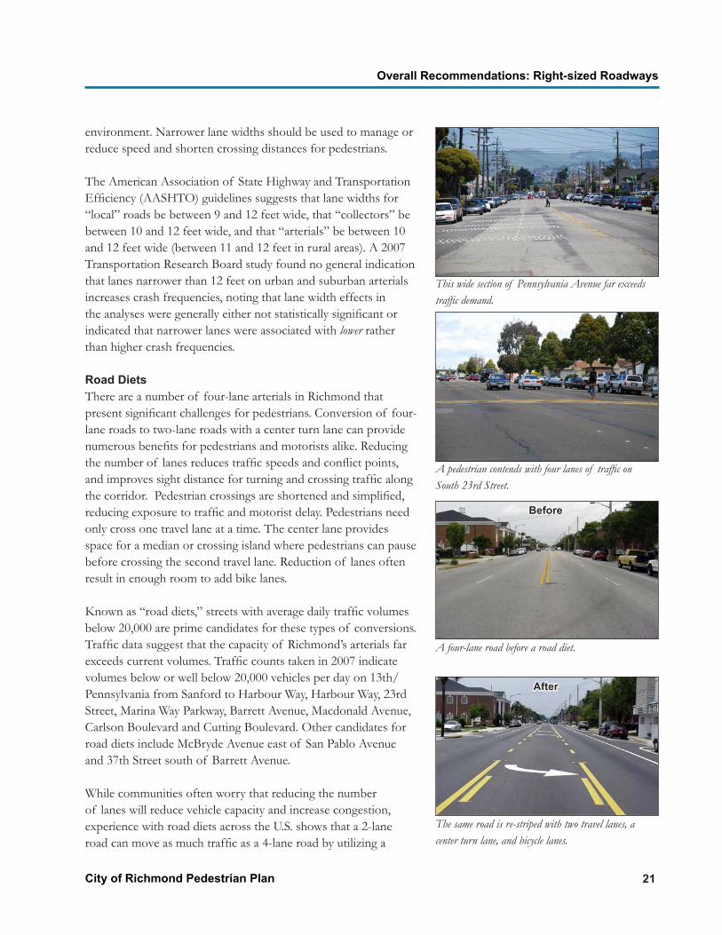
Road DietsThere are a number of four-lane arterials in Richmond that present significant challenges for pedestrians. Conversion of four-lane roads to two-lane roads with a center turn lane can provide numerous benefits for pedestrians and motorists alike. Reducing the number of lanes reduces traffic speeds and conflict points, and improves sight distance for turning and crossing traffic along the corridor. Pedestrian crossings are shortened and simplified, reducing exposure to traffic and motorist delay. Pedestrians need only cross one travel lane at a time. The center lane provides space for a median or crossing island where pedestrians can pause before crossing the second travel lane. Reduction of lanes often result in enough room to add bike lanes.
Known as “road diets,” streets with average daily traffic volumes below 20,000 are prime candidates for these types of conversions. Traffic data suggest that the capacity of Richmond’s arterials far exceeds current volumes. Traffic counts taken in 2007 indicate volumes below or well below 20,000 vehicles per day on 13th/ Pennsylvania from Sanford to Harbour Way, Harbour Way, 23rd Street, Marina Way Parkway, Barrett Avenue, Macdonald Avenue, Carlson Boulevard and Cutting Boulevard. Other candidates for road diets include McBryde Avenue east of San Pablo Avenue and 37th Street south of Barrett Avenue.
While communities often worry that reducing the number of lanes will reduce vehicle capacity and increase congestion, experience with road diets across the U.S. shows that a 2-lane road can move as much traffic as a 4-lane road by utilizing a
A four-lane road before a road diet.
The same road is re-striped with two travel lanes, a center turn lane, and bicycle lanes.
This wide section of Pennsylvania Avenue far exceeds traffic demand.
A pedestrian contends with four lanes of traffic on South 23rd Street.
Before
After

City of Richmond Pedestrian Plan 22
Overall Recommendations: Right-sized Roadways
Two travels lanes are removed and replaced with bicycle lanes and angled parking on one side, increasing the number of on-street parking spaces.
A road diet creates space for a crossing island, where pedestrians can pause before crossing the next lane of traffic. Crossing islands encourage motorists to yield to pedestrians.
The illustrations show how rear end, side-swipe and broadside crashes can be reduced by going from four lanes to three lanes.
Turn
Lan
e/M
edia
nTu
rn L
ane/
Med
ian
Before After
Before
After
center turn lane. The turning pocket shifts left turning vehicles out of the travel lane and allows the traffic to flow more smoothly, with fewer conflicts and better sight lines, though at lower speeds. Numerous conversions throughout the country have been implemented without losing capacity or experiencing unacceptable intersection levels of service.
Five lane street before a road diet.

23City of Richmond Pedestrian Plan
Overall Recommendations: Compact Intersections
Compact IntersectionsMost urban crashes occur at intersections and are associated with turning movements. Keeping intersections tight, simple and slow speed make them safer for motorists and non-motorists alike.
Many intersections in Richmond are wide, creating difficult crossing conditions for pedestrians and bicyclists. Some are skewed, which lengthens crossings and the ability for motorists to turn at high speeds. Skewed intersections force drivers turning right to look over their shoulders for approaching traffic and makes it difficult to detect pedestrians coming from the right and cyclists in the bicycle lane. Straightening skewed approaches better places pedestrians and cyclists into drivers’ line-of-sight. Streets that intersect at right angles also decrease crosswalk lengths.
Curb RadiiWide corner radii generally increase intersection size and lead to higher turning speeds. The larger the radius, the longer the pedestrian crossing distance and exposure to traffic, and the greater the chance the pedestrian will fall outside the line-of-sight of the driver. Richmond should adopt standards to minimize curb radii to the extent feasible to accommodate the specified design vehicle associated with specific locations. Smaller radii will help provide shorter crossings for pedestrians and require slower vehicle turning speeds, depending on the width of the street. Other likely benefits include:
•• Better alignment of the crosswalk with the connecting sidewalks.
Top Left and Right: The skewed intersection at Macdonald and Broadway makes it difficult to align crosswalks and stop bars; the photo to the right shows how the skewed angle of the intersection combined with wide corners produce a lengthy crossing and expose pedestrians to high speed right and left turning vehicles. Middle Right: A vehicle fails to yield for a pedestrian at a wide corner. Above: A compact, pedestrian-friendly intersection in Santa Barbara.

City of Richmond Pedestrian Plan 24
Overall Recommendations: Compact Intersections
•• Easier installation of ADA-compliant directional curb ramps (instead of diagonal ramps).
•• Improved visibility of pedestrians.•• Shorter pedestrian crossing clearance time, reducing
motorist delay.
The choice of “design vehicle” determines how large a radius should be. The design vehicle is not the largest vehicle that may occasionally make a turn, but the vehicle that regularly makes a turn and whose movements should be accommodated. For example, a large moving van will occasionally have to make a turn into a local street. It can make it, though slowly and by taking the entire roadway. This may block traffic momentarily, but happens infrequently enough that it may be deemed acceptable. Other considerations that factor into the radius are the presence of bike lanes and on-street parking, which increase the effective radius of a curb.
The City of Oakland’s Pedestrian Master Plan recommends a 10 foot turning radius for streets with curb-side parking and a 20 foot radius for streets without curb-side parking. Richmond should consider adopting a similar standard. The Oakland Plan notes that streets with significant volumes of truck traffic may require larger corner radii. Large radii may also be required on transit routes at corners with frequent bus turning movements. Buses can generally maneuver at intersections with 25 foot curb radii.
Curb ExtensionsCurb extensions, sometime referred to as bulbouts, extend the curb line into the street, typically to the width of the parking lane, at intersections or midblock locations where cars would not be allowed to park. They shorten pedestrian crossing distances and calm traffic. They also reduce pedestrian clearance intervals for waiting motorists. Motorists are encouraged to travel more slowly at intersections with curb extensions because of physical and visual narrowing of the street. Extended curbs also slow turning movements and improve sight lines for pedestrians and motorists. Other benefits include:
• Space for street furniture and reduced sidewalk clutter.•• Improved driver yield rate to pedestrians (presence of a
pedestrian in an extended curb area sends a clear signal of intention to cross).
• Enables traffic signs to be moved inward where they are
It is important to consider the effective radius appropriate for vehicles most likely to use an intersection. It will be larger than the actual built curb radius if the travel lane is offset from the curb with a parking and/or bike lane.
Above: Curb extensions with furniture and greenery on Macdonald Avenue.

25City of Richmond Pedestrian Plan
Overall Recommendations: Mini-Circles and Roundabouts
more visible. •• Can create inset areas for parking, or “parking pockets.”
The parking area can be paved with alternative material, maintaining a perceived narrow roadway even if no cars are parked.
•• Space for bus shelters and efficient passenger loading and unloading.
•• Space for greenery, stormwater drainage and filtration.
The City of Sacramento Street Standards include the general criteria that curb extensions should not extend further than 6 feet into the street adjacent to parallel parking, or 12 feet adjacent to diagonal parking. However, the sizing, design, cost and feasibility of bulbouts will depend upon parking lane widths, clearance for bicycle lanes, the need for drainage modifications, and large vehicle turning movements.
Mini-Circles and RoundaboutsMini-circles and roundabouts can be used at intersections to reduce speed, reduce conflicts between motor vehicles and between vehicles and pedestrians, and for aesthetic enhancements.
Mini-circles are raised islands or large planters arranged in a circle, or other elements that cause vehicles to move slowly through intersections in a counter-clockwise direction. They are appropriate for use on local streets where speeds and volumes are low and are effective tools to moderate speeds and encourage motorists to yield to pedestrians and bicyclists crossing the street. Large vehicles such as fire trucks are allowed to make left turns in front of the circles. Berkeley has over 60 circles with stop controls and is considering removing controls and converting the intersections to all-way yields.
Roundabouts are an alternative to signalized or stop-controlled intersections. They use a raised circular island to allow large volumes of traffic to pass counterclockwise through an intersection at low speed without the use of stop signs or signals.
Though roundabouts are becoming more common in California, communities may raise concerns when they are first proposed. However, once built, residents often recognize that they are safer, quieter and more attractive than signalized intersections. Traffic engineers are recognizing that roundabouts are safer and can be
Top to Bottom: Curb extension with diagonal parking on Macdonald Avenue. Extension with curb cut for stormwater drainage and infiltration. Mini-circles in a series slow traffic on a Seattle street. A landscaped traffic circle in Sacramento.

City of Richmond Pedestrian Plan 26
Overall Recommendations: Mini-Circles and Roundabouts
more efficient than a typical stop-controlled or signalized intersection. The lower speeds and more predictable vehicular movement provide safety benefits for pedestrians and bicyclists:
•• A typical 4-way intersection has 32 vehicle-to-vehicle conflicts and 24 vehicle to pedestrian conflicts. At a roundabout these conflicts are reduced to 8.
•• Properly designed roundabouts will bring vehicle speeds down to 15-20 mph, speeds at which motorists are much more likely to yield to pedestrians and the frequency and severity of accidents are greatly diminished.
•• Roundabouts are designed with a splitter island that provides a refuge for pedestrians as they cross the street and simplifies the crossing by letting them focus on vehicles traveling in only one direction.
•• Bicyclists can take the travel lane since vehicles are circulating at a comfortable bicycle speed. Less confident bicyclists can be provided a ramp on the approach to the roundabout so they can exit and use the sidewalk to walk their bicycle to the crosswalk.
Roundabouts can be designed to accommodate the largest trucks with a mountable truck apron to allow space for wheels or equipment to pass over for turning movements.
Roundabouts can increase intersection capacity by up to 30 percent and reduce delay, reduce the need for storage lanes, and improve traffic flow at intersections with frequent left turns. They can be design with an additional lane on legs that might require greater capacity. Roundabouts save signal maintenance and energy costs and have a longer service life than signal equipment.
Separated sidewalks direct pedestrians to crosswalks
Crosswalk 1 car length back
Splitter Island
Slow speed entry = yield at crosswalk
Slow speed exit
Truck apron
Deflection = slow speeds throughout
Roundabout Essential Characteristics

27City of Richmond Pedestrian Plan
Overall Recommendations: Crossings
CrossingsSafe and frequent crossings are necessary for an effective pedestrian infrastructure. Crossings are a routine part of almost every walking trip. Richmond’s grid network of frequently spaced intersections provides a strong foundation for an enhanced crossing system through a number of treatments.
California state law requires motorists to yield to pedestrians in both marked and unmarked crosswalks at intersections. Pedestrians can legally cross at midblock (except between adjacent intersections controlled by traffic signals or by police officers), but must yield to motor vehicles.
Controlled IntersectionsStriped crosswalks are used to show pedestrians where to cross and to show drivers where to expect them. At signalized intersections, at a minimum, installation of marked crosswalks consisting of two standard parallel lines should be considered on all approaches with an advance limit line (stop bar) at least 4 feet before the crosswalk, unless marking a crosswalk at a specific location is determined by the City to be unsafe. Advance stop lines discourage vehicle encroachment into the crosswalk and failure to stop for pedestrians on right-turn-on-red. Intersections with increased pedestrian activity are candidates for high visibility crossing treatments (discussed below). At stop sign controlled intersections, installation of dual parallel lines should also be considered for all approaches.
Uncontrolled IntersectionsCrosswalks at all uncontrolled intersections, midblock locations, and areas with high pedestrian and bicyclist volumes such as schools, parks, community centers, transit centers and commercial districts, should be high visibility crossings. At a minimum, this includes a pavement striping pattern with perpendicular markings. Richmond has used a “zebra” pattern at certain locations which is more visible to motorists than the standard two parallel lines. The City should consider adopting the “triple four” pattern used by the City of Sacramento or similar high visibility bars marked with thermoplastic rather than regular paint, to ensure that it has a high degree of reflectivity and will perform well over time.
Marked crosswalks are one tool to get pedestrians safely across the street. When considering marked crosswalks at uncontrolled locations, the question should not simply be: “Should I provide a marked crosswalk or not?” Instead, the question should be: “Is this an appropriate tool for getting pedestrians across the street?” Regardless of whether marked crosswalks are used, there remains the fundamental obligation to get pedestrians safely across the street.
In most cases, marked crosswalks are best used in combination with other treatments (e.g., curbextensions, raised crossing islands, traffic signals, roadway narrowing, enhanced overhead lighting, traffic calming measures etc.). Think of marked crosswalks as one option in a progression of design treatments.
If one treatment does not adequately accomplish the task, then move on to the next one. Failure of one particular treatment is not a license to give up and do nothing. In all cases, the final design must accomplish the goal of getting pedestrians across the road safely.
Source: Safety Effects of Marked vs.
Unmarked Crosswalks at Uncontrolled
Locations, Federal Highway Administration
Zegeer, et al.

City of Richmond Pedestrian Plan 28
Overall Recommendations: Crossings
Crosswalk Visibility
Top Left and Right: standard parallel and variations of perpendicular or longitudinal striping patterns. Longitudinal bars are more visible to approaching motorists. Middle Left and Right: Specifications for Sacramento’s high visibility crosswalks. “Triple four” crosswalk in Sacramento. The gap between the bars provides a non-skid surface for pedestrians and a smooth surface for wheelchairs. Above: “Zebra” style pattern on Harbour Way in Richmond.
Triple 4 High Visibility Pattern
Source: City of Sacramento Pedestrian Safety Guidelines
Downward arrow required at crosswalk
Above: The City should continue to install new signs to alert motorists they are approaching locations where pedestrian crossing activity is unexpected or not readily apparent and update old signs per MUTCD standards. Pedestrian crossing signs at crosswalks require a downward arrow beneath the sign pointing to the marked crosswalk.

29City of Richmond Pedestrian Plan
Overall Recommendations: Crossings
High visibility markings should be used in conjunction with “SLOW PED XING” stenciled pavement markings and standard fluorescent yellow green pedestrian crossing signs in advance and adjacent to the crosswalk to alert drivers to the presence of pedestrians.
Advanced yield lines to set waiting vehicles back from crosswalks should be considered at midblock locations without stop controls. They are particularly important for multi-lane crossings (more than two lanes) to reduce the risk of a “multiple threat” crash when a vehicle stopped for a crossing pedestrian blocks the view of a vehicle approaching in the next lane. The federal Manual of Uniform Traffic Control Devices recommends a twenty to fifty-foot setback (1 to 2 car lengths) for the yield line.
A 2002 report published by the Federal Highway Administration on the safety effects of marked versus unmarked crosswalks at uncontrolled street crossings suggests marked crosswalks alone can be sufficient on low volume, low speed two-lane roads. But streets with higher volumes, more lanes and higher speeds require additional treatments for safe crossings.
A comprehensive policy for identifying candidate locations and treatments for marking crosswalks at uncontrolled crossings is included in the Appendix.
Lighting and SignalsPedestrian crashes occur disproportionately at night. Proper illumination makes the pedestrian visible. Lighting at all crossing locations should be installed or retrofitted to direct illumination onto the crosswalk. The City of Oakland Pedestrian Master Plan provides lighting guidelines for crosswalk illumination (p. 64).
Early in 2010, a new Manual of Uniform Traffic Control Devices (MUTCD) was adopted at the federal level. The manual contains changes regarding signals at intersections that the City should consider. These include reduction of the walking speed used to set the walk phase of pedestrian signals from 4 feet per second to 3.5 feet per second and the installation of pedestrian signal countdown heads on all new and retrofit projects. The reduced walking speed provides pedestrians, including seniors and persons
Traffic control devices are governed by the procedures and policies set forth in the Manual of Uniform Traffic Control Devices (MUTCD) at the state and federal levels. Devices include traffic signals, traffic signs, and street markings. The MUTCD covers their design, placement, operation, and maintenance. The CA MUTCD emphasizes uniformity of traffic control devices to simplify the task of all users by aiding recognition and understanding, thereby reducing perception and reaction time. A uniform device conforms to regulations for design, use, and location.
Above: Lighting is directed to illuminate crosswalks at night.

City of Richmond Pedestrian Plan 30
Overall Recommendations: Crossings
with disabilities, with more time to complete crossings. The Berkeley Pedestrian Master Plan recommends considering walk phases set at 2.8 to 3.5 feet per second for all high pedestrian demand locations. If there are special land uses such as senior centers or schools within proximity of the intersection, Richmond should consider slower walking speeds.
Countdown signals let pedestrians know the amount of time remaining in the walk phase. These have been shown to improve pedestrian compliance with signals and reduce “dashes” into the crosswalk. Richmond has installed countdown signal heads on Cutting Boulevard and Macdonald Avenue at locations with high crossing demand and should continue to do so, especially at wide intersections with long crossing distances. Replacing traffic signal bulbs with LED bulbs is also recommended to increase visibility and improve efficiency. The California MUTCD will be updated in coming years and may reflect these changes.
Leading Pedestrian Intervals (LPI) provide pedestrians with a “head start” signal timing (usually 3 to 5 seconds) to establish their presence in the crosswalk before vehicles get a green light in the same direction. A 2000 study for the Insurance Institute for Highway Safety found that the LPI reduces conflicts between turning vehicles and pedestrians by enhancing the visibility of the pedestrian in the crosswalk. The LPI is especially effective at intersections with a high number of conflicts between left or right-turning vehicles and pedestrians. No LPIs are installed in Richmond. The City should consider installing LPIs in areas of high pedestrian activity, and consider a right-turn on red restriction as necessary per recent research findings.7
Crossing IslandsRaised medians and islands can reduce the likelihood of pedestrian accidents. They break long, complex crossings into two shortened, simplified legs. The pedestrian looks left, crosses to the median refuge, looks right, and crosses the second half of the roadway. This simplifies the task of finding a gap long enough to cross the entire roadway in one movement.
7Van Houten, R.; Retting, R.A.; Farmer, C.M.; and Van Houten, J. 2000. “Field Evaluation of a Leading Pedestrian Interval Signal Phase at Three Urban Intersections.” Transportation Research Board Record 1734:86-92; Hubbard, S, Bullock, D and J. Thai, “Trial Implementation of a Leading Pedestrian Interval: Lessons Learned”, ITE Journal, October 2008, pp. 32-41.
Staggered median crossing island.
Pedestrian countdown signal on Macdonald Avenue.
Car yields to pedestrian at crossing island in Sacramento.
Angled refuge area directs attention to oncoming traffic.

31City of Richmond Pedestrian Plan
Overall Recommendations: Crossings
The photos above show recently built refuge islands in a continuous raised median in a four-lane roadway in West Sacramento. The photo on the top left shows a refuge island built though a median nose extended into a signalized intersection. The other three photos show a bicyclist and pedestrians using an angled median at a midblock location. Both types of median refuges use alternative paving treatments to clearly define the pedestrian travel way and bollards with lights to further distinguish and highlight the refuge areas. High visibility longitudinal crosswalk bars are used at the unsignalized midblock location.
As a general rule, refuge islands should extend through the crosswalk, with a curb cut for wheelchair accessibility. The cut through can be angled so that pedestrians face oncoming traffic. In order to improve wayfinding for pedestrians with visual impairments, the ends of the cuts must align with the crosswalk.
Crossing islands can also be designed with crosswalks staggered so that pedestrians cross half the street and walk toward traffic in the refuge to reach the second half of the crosswalk. This measure must be designed for accessibility by including curbs and truncated domes to direct sight-impaired pedestrians along the path of travel. Islands should be at least 6 feet wide, the length of an average bicycle, and designed with contrasting materials and landscaping for increased visibility. They should be at least 12 feet long, or the width of the crosswalk (whichever is greater).

City of Richmond Pedestrian Plan 32
Overall Recommendations: Sidewalk Zones
Sidewalk ZonesSidewalks are needed on both sides of all urban streets in Richmond. The American Association of State Highway and Transportation Officials (AASHTO) policy on highway and street design states “sidewalks are integral parts of city streets.” Research by the Federal Highway Administration shows that the presence of sidewalks on both sides of the street is related to significant reductions in “walking along roadway” pedestrian crashes compared to locations without sidewalks or walkways. Reductions of 50 to 90 percent of these types of pedestrian crashes have been found in the research.
Sidewalks line the roadways of central Richmond, serving as the principal facility of the city’s pedestrian network. Sidewalk widths vary, but are generally 5 feet on residential streets, and 4 feet on some blocks. 5 feet is necessary for two people to walk comfortably side-by-side and allow ease of passage by people using canes, wheelchairs, or other mobility assistance devices. 6 feet is preferred. Sidewalk widths on existing commercial street segments tend between 8 and 15 feet. While 8 foot widths can accommodate more pedestrian activity, greater widths may be desirable in high pedestrian use areas, such as portions of Macdonald Avenue and 23rd Street.
The sidewalk should be considered a part of a pedestrian corridor that extends from the edge of the roadway to the edge of the public right-of-way (ROW), or from the curb line to the property line. The pedestrian corridor is separated into four distinct zones to accommodate a wide range of uses and prevent conflicts between the various functions of the sidewalk. The four zones include:
•• Curb zone•• Furniture/Green Zone•• Pedestrian Through Zone•• Frontage Zone
The curb zone defines the transition between the street and the sidewalk corridor. Curbs prevent water from overflowing on to sidewalks and properties and make it easier to sweep the streets. Flat-faced vertical curbs are best to define the edge of the vehicle boundary and to ensure parked cars don’t encroach on the sidewalk.
Next to the curb is a landscape strip or furniture zone that buffers the pedestrian zone from the street. Trees, streetlights, benches, transit stops, bike racks, signs, utilities, and other objects are placed in this zone. The preferred minimum width for landscape strips is six feet to accommodate street trees, but may vary in sections with right-of-way constraints.
Next to the Furniture/Green Zone is the Pedestrian Zone, an accessible pathway clear of obstacles where people walk and talk. This area requires a smooth surface for safe and comfortable use by individuals of all ages and abilities. All sidewalks are sloped for drainage, but a slope that is too steep is challenging for people who use wheelchairs, walking aids, or who have difficulty walking but do not use aids. The cross-slope must not exceed 2 percent (1:50) as specified in ADA Accessibility Guidelines.

33City of Richmond Pedestrian Plan
Overall Recommendations: Sidewalk Zones
Landscaped buffer between the curb and sidewalk in Richmond mixed use transit village.
Comparison of Zone Widths
Pedestrian Corridor Zones: Residential
Pedestrian Corridor Zones: Commercial and Mixed Use
The table shows recommended zone widths in the Berkeley Pedestrian Master Plan and the Oakland Pedestrian Master Plan.
The Richmond Municipal Code addresses obstructions to the street and sidewalk and provides requirements for permissible encroachments. The City recently amended the Code to allow eating establishments to obtain permits for outdoor seating and services on public sidewalks, an important step to support economic development and streetside pedestrian activity. The City should continue to monitor and update standards to ensure that the pedestrian through zone is kept free and clear of obstructions.
The frontage zone is the space between the through zone and the adjacent property line. It separates sidewalks from buildings, fences, and walls. In most cases the frontage zone should be at least one foot. Sidewalk users generally avoid direct adjacency to structures and objects at the property line, such as doors, windows, walls and fences.
City Street Type Curb Zone
Furniture Zone
Through Zone
Frontage Zone
CorridorWidth
Berkeley Major Street, Pedestrian District
0’ - 6” 4’ 8’ 6” - 2’ 15’
Collector Street 0’ - 6” 4’ 6’ 6” - 1’ 12’Local Street 0’ - 6” 4’ 6’ 0’ - 6” 11’
Oakland Arterial -- 4’ 8’ -- 12’Collector -- 4’ 6’ -- 10’Local -- 4’ 5’ -- 9’Walkway -- -- 4’ -- --Trail -- -- 6’ -- --
The upper and lower images show the arrangement of sidewalk corridor zones on residential and commercial and mixed use streets.

City of Richmond Pedestrian Plan 34
Overall Recommendations: Sidewalk Zones
People will shy away from a vertical space. More width is needed in the frontage zone in the photo above.
The type of fence material impacts pedestrian comfort: the sidewalk on the left is wider, but feels constrained because of a high chain link fence.
The through zone is restricted by a trash container and landscaping on Macdonald Avenue.
Above: This photo of a street in Point Richmond shows how an interesting façade can make a narrow sidewalk feel wider.
Signs block the sidewalk on Cutting Boulevard.
A car blocks the sidewalk on a residential street in Richmond.
Left: Outdoor seating areas such as this one in Point Richmond add space for activity. The City recently amended the Code to allow outdoor eating service on sidewalks adjacent to food establishments as long as encroachments do not obstruct the pedestrian travel lane.

35City of Richmond Pedestrian Plan
Overall Recommendations: Sidewalk Zones
DrivewaysEvery driveway crossing is a potential conflict for pedestrians.. Unnecessarily wide driveways encourage higher turning speeds and expose drivers and pedestrians to increased risk. Driveway curb cuts that extend into the pedestrian through zone may pose a tripping hazard to people on foot, can compromise balance and stability for people in wheelchairs, and disrupt the pedestrian path with slopes and undulations.
Residential and commercial driveways in Richmond should be designed to enable the sidewalk to continue across the driveway at the same level and slope. As is characteristic of neighborhoods built before the 1960s, many sidewalks in Richmond’s residential neighborhoods have, or once had, a planting strip between the curb and sidewalk. This makes them typically wide enough to place the driveway ramp in front of the sidewalk outside of the pedestrian travel way. The sidewalk area along Richmond’s commercial arterials are also generally wide enough for placement of driveway ramps in the furniture zone and outside the pedestrian through zone. In addition to reducing obstructions to the pedestrian path, locating driveway aprons in front of the sidewalk will slow motorists and increase driver attention before they cross the sidewalk and interact with pedestrians.
The City should update its standards to ensure the ramp portion of driveways be located in the furniture/green zone. A maximum 2 percent cross slope through the sidewalk area is required by ADA Accessibility Guidelines, with a minimum passage space of 3 feet, which is expected to soon be increased to 4 feet.
Over time the City should work with property owners to minimize driveway widths and frequencies through consolidation into shared entries and exits. Access management can be improved through the use of right-in, right-out (or single direction) driveways, which is especially effective on multiple lane roadways. In addition to reducing the number of unnecessary vehicle turning opportunities and conflicts that make roads inefficient, managing access to fewer points lengthens the pedestrian’s comfort zone and minimizes the possibilities for vehicle-pedestrian conflicts.
Vehicles parked in driveways that partially or completely block sidewalks is a persistent problem in many Richmond neighborhoods. This forces pedestrians into the driveway ramp or street to maneuver around parked cars.
A wide driveway on Cutting Boulevard lengthens pedestrian exposure to potential conflicts.
Example of a narrower driveway where the sidewalk area is clearly delineated from the driveway ramp.
Where sidewalks are narrower it is sometimes possible to wrap the sidewalk around the driveway apron.
Larger driveway openings can be divided into right turn in and right turn out sections to reduce conflicts between turning vehicles and between vehicles and pedestrians. Crossing treatments can be added to send a clear message to drivers that they are crossing a sidewalk.

City of Richmond Pedestrian Plan 36
Overall Recommendations: Sidewalk Zones
California Vehicle Code sections 22500 (e) and (f) prohibit parking that blocks a portion or all of the sidewalk and may be subject to citation. Given the scope and persistence of the problem, this plan identifies the following actions:
1. Consider a range of traffic calming solutions that maximizes parking on the street and increases perceptions of safety and security. This will help provide additional alternate spaces for residents and guests to park vehicles. On-street parking is discussed in the next section.
2. Work with a community group, neighborhood action committee and/or neighborhood council to carry out a community-driven public information and notification effort to eliminate vehicle blockage of sidewalks. This could be initiated in a focused area (e.g., 3 - 5 blocks) that can serve as a model for other neighborhoods and the City. WALKSacramento, a nonprofit community organization that works to improve the walking environment in the Sacramento metropolitan region, developed a “warning” that neighbors could place on cars that was politely worded.
3. Consider striping parking lanes or “T” markings in pilot locations to reduce concerns about potential side swiping and increase comfort with parking on the street. As an example, on 19th Avenue in San Francisco, the Department of Parking and Traffic placed flyers on illegally parked vehicles with a warning that they were to park in the street between a new white line painted by Caltrans and the curb, or risk being ticketed and towed. The combination of markings and citations has contributed to less sidewalk blockage from cars.
Curb RampsState law and the Americans with Disability Act (ADA) Accessibility Guidelines require all streets with sidewalks and curbs to have curb ramps at intersections. Perpendicular corner curb ramps, a separate ramp installed in each direction, are preferable where feasible to single, diagonal corner ramps because they direct users into the crosswalk and maintain a straight path between sidewalks on both sides of the street. The ADA Public Rights of Way Access Guidelines, which will be adopted at the national level in the next few months, strongly support two directional ramps on each corner. The Standard Drawings for the City of Sacramento include best practices for directional curb ramp design (see
Cars block sidewalk in Richmond.
Example of a notice placed on cars blocking sidewalks in Sacramento.
Directional curb ramps with truncated dome panels at the bottom of the ramp aid detection of transition into the street.
Single diagonal curb ramp.

37City of Richmond Pedestrian Plan
Overall Recommendations: Sidewalk Zones
drawing T-77 at http://www.cityofsacramento.org/utilities/pubs/stdspecs/Transportation.pdf).
The City should include curb ramp installation at all street intersections as part of the street resurfacing, sidewalk improvement, utility, new construction, and alteration projects.
Pedestrian Scale LightingMotor-vehicle scale street lights focus light on travel lanes and intersections. Pedestrian-scale street lights direct light on to walkways. Lampposts are spaced more frequently at lower heights, providing a vertical buffer between the street and sidewalk. They help activate streets, paths and other public spaces by adding illumination at the pedestrian level. Safety, comfort and security are improved through increased visibility.
Pedestrian-scale street lights should be considered for installation in high pedestrian activity areas, especially in commercial districts where nighttime retail, restaurant and entertainment services are encouraged, in areas with a history of high crime rates, or around schools. Criteria for pedestrian lighting include:
• Lampposts are a maximum 10 to 16 feet in height. • Designs need to withstand vandalism. • Designs and materials fit with neighborhood or district
character. • Light fixtures direct light where it is intended. Consider using
partial or total cut-off fixtures (covers or hoods) to reduce glare, light trespass, and help preserve dark night sky.
• Choose appropriate lamp type for the location that balances illumination level, color rendering, energy efficiency, reliability and cost (see table on next page).
Proposed lighting guidelines in the Oakland Pedestrian Master Plan located lampposts at 50’ intervals at a height of 14’ on arterials, and 12’ on collector and local streets. Illumination levels for pedestrian ways on the three types of streets are 0.9 foot candle, 0.6 foot candles and 0.2 foot candles, respectively. The Berkeley Pedestrian Master Plan recommends illumination of pedestrian ways between 0.5 to 1 foot candle.
Curb extension with broad curb ramp, framed by corner building, contributes to a walkable environment.
Vehicle Scale Pedestrian Scale
Pedestrian scale lighting adds framing, comfort and security to the sidewalk.
Pedestrian scale lighting compared to conventional streetlight.

City of Richmond Pedestrian Plan 38
Overall Recommendations: Sidewalk Zones
Lamp Type Efficacy(lumens per watt)
Pros Cons
Mercury Vapor 13-48 -Dimmable-Good initial color rendering; white/ blue light
-Inefficient, older technology-Use of hazardous material (mercury)-Medium life (~ 16,000 hours)
High Pressure Sodium
45-110 -Very energy efficient-Widely used, reliable
-Orange/yellow light-Aesthetic and safety concerns due topoor color rendering-Cannot restrike immediately
Low Pressure Sodium
80-180 -Most energy efficient option-Minimum glare-Able to restrike immediately
-Yellow light- Aesthetic and safety concerns due topoor color rendering-Expensive fixtures
Metal Halide 60-100 -Good color rendering; nice white light-More efficient than mercury vapor-Widely used
-Shorter life than HPS (up to 20,000 hours)-Less efficient than sodium lamps
Induction 61-76 -Long life (~ 100,000 hours)-Good color rendering; nice white light-Immediate ignition and restrike-No flickering
-High initial cost-Difficult to retrofit existing fixtures-Uses small amount of mercury-Not dimmable-Needs a high-frequency generator
Lamp Types: Pros and Cons
Clockwise Starting From Left. Hooded pedestrian lamps on Nevin Avenue in Richmond. Well-lit sidewalk in Merced, CA. Pedestrian lighting combined with low level bollards illuminate the sidewalk area in Mill Creek, WA.

39City of Richmond Pedestrian Plan
Overall Recommendations: Sidewalk Zones
Street TreesTrees planted in the furniture/green zone between the curb and sidewalk add a vertical buffer between moving vehicles and pedestrians. When located near the street edge, they provide visual interest and enclosure that heightens motorist recognition of speed and encourages caution. They also provide shade and cover for pedestrians, absorb air pollutants, capture rainfall and facilitate rainfall percolation into the ground, which reduces flooding and washing of contaminants into the bay. Studies have shown trees to have a positive impact on sales in business districts, crime reduction in low income neighborhoods, and residential property values.
Most sidewalk corridors in Richmond are eight feet wide or more, with potential to accommodate properly sized, planted and maintained street trees. Many corridors are ten to twelve feet wide, with six-foot planting strips between the curb and sidewalk. Six feet is generally the minimum width required for a large canopied tree to minimize root conflict with the sidewalk and curb. Eight to ten feet is preferred for large trees. Trees can be located in planters, crushed granite in tree wells or grates in the furniture zone on sidewalks that do not include continuous planting strips.
Richmond’s older arterials have under-used paved area that could be converted to wider landscaped space for roadside tree planting, and in some cases, offer room for development of medians that could accommodate trees. Road edges could be rebuilt with stormwater planters to receive, infiltrate and clean runoff from the roadway. As an example, a series of planters were recently installed on two block-long stretches of San Pablo Avenue in El Cerrito. Medians can also be designed to receive stormwater, but would require roadway regrading to direct flow toward the center of the street instead of the curb.
Trees can also be located in curb extensions and tree wells between on-street parking spaces where sidewalks are narrow on smaller residential streets to provide traffic calming and create well-canopied neighborhoods. Curb extensions can be designed with curb cuts to absorb stormwater runoff. They can be relatively inexpensive to build, but may require the removal of some on-street parking spaces.
Right. Trees in recently constructed stormwater planters on San Pablo Avenue in El Cerrito. Source: San Francisco Estuary Partnership (photo by Lisa Owens Viani).
Tree planted in traffic circle in Seattle.
Tree planted curb extension in Santa Cruz.

City of Richmond Pedestrian Plan 40
Overall Recommendations: Sidewalk Zones
Tree Planting in Constrained Locations
Large healthy trees produce the most benefits for air quality, water quality, shading and energy savings. But the right tree must be selected based on space constraints below ground, on the surface and above.
In order for street trees to be successful, appropriate species need to be matched with the available space. Smaller trees must be selected for location under overhead power lines. Trees must not be planted directly over underground utilities and should be set back twenty to thirty feet at intersections to avoid blocking sight lines. Shallow-rooting species should be avoided and trees should be located a minimum of three feet from sidewalks, curbs and paving. Matching tree species to the site’s available soil volume will also help reduce the likelihood of sidewalk and curb conflict. The use of structural soils can facilitate tree health and reduce pavement uplifting. Structural compounds use coarse materials that can be compacted to bear heavier loads but still allow root penetration for healthy growth.
Richmond has actively pursued funding to identify planting opportunities throughout the city, set tree canopy goals, develop design standards and pursue maintenance districts to manage the urban forest. As part of this effort, the City should develop a street tree plan for appropriate tree types, spacing, tree well sizes, maintenance standards, tree preservation, and to prevent conflicts with utilities and street lights. The Northern California Coast Community Tree Guide published by the USDA Forest Service Pacific Southwest Research Station is a good resource for the selection, planting and maintenance of trees for both public and private spaces. The San Mateo County Green Streets and Parking Lots Design Guidebook is a useful resource that combines traffic calming and pedestrian-oriented goals with green infrastructure design strategies, techniques and standards.

41City of Richmond Pedestrian Plan
Overall Recommendations: Bikeway Facilities
Placing utilities underground reduces conflicts between trees and poles and overhead wires. Electrical wires and other utilities are run through conduits in streets, lanes and easements. Service wires to homes and businesses are also placed underground. This removes visual clutter and can make more space on sidewalks available for pedestrians, trees and other uses. As more utilities are undergrounded, safety and service reliability improve because of reduced exposure to damage or collapse from storms, wind and earthquakes.
Typical sources of funding for conversion of overhead utilities to underground include utility ratepayer funds regulated by the California Public Utilities Commission, property assessment districts, and developer fees. The City should consider development of a utility undergrounding program to identify and target funds, and explore the feasibility of conversion in targeted locations.
Bikeway FacilitiesPlanning and design for bicyclists and pedestrians in Richmond are mutually supportive. Both focus on connectivity and direct links between destinations and roadways that safely accommodate motorists and non-motorists alike.
The 2011 Richmond Bicycle Master Plan delineates a comprehensive bikeway network that includes Class I, II and III facilities as defined by Caltrans, all of which contribute to improvement of the pedestrian environment. Class I bikeways are separated paths for exclusive bicycle and pedestrian use, with motor vehicle cross-flow minimized. Class II bikeways are striped lanes on streets and highways designated for bicycles. Class III bikeways are routes designated by signs or pavement markings for shared use with pedestrians or motor vehicle traffic. Not all shared streets are designated as bikeways, and much bicycling occurs on streets that are not designated facilities. The designation is generally reserved for facilities which provide continuity to other bicycle facilities or for preferred routes through high demand corridors.
Shared use paths benefit pedestrians and bicyclists by providing opportunities for off-street connections to multiple destinations, recreation and exercise, with little or no exposure to conflict with motor traffic. Striped on-street bike lanes provide space for bicycling, but can also have a traffic calming
Tree-lined street in Santa Cruz, Ca.
Recently planted trees in West Sacramento, Ca.
Planters with inlets to receive runoff in West Sacramento.
Dense canopy on 36th Street in Richmond.

City of Richmond Pedestrian Plan 42
Overall Recommendations: On-Street Parking
effect by adding definition and friction to the road edge, and by visually narrowing the roadway. In addition, the preferred width for bicycle lanes proposed in the Bicycle Master Plan is six feet, which provides a buffer space between traffic and the sidewalk.
The Bicycle Master Plan also suggests enhanced Class III routes known as Bike Boulevards. These are designated routes that are integral to a bikeway system, but may be too narrow for a bicycle lane or have low enough vehicle volumes that a bicycle lane is less necessary. Ideally, motor vehicle traffic is slowed to approximately the same speed as the bicycle speeds. The development of a bicycle boulevard may include the alteration of intersection controls and the installation of signs and stencils. Stop signs and traffic signals on the bicycle boulevard are limited, except where they aid bicyclists in crossing busy streets. Typically, these and other modifications to enhance bicycle safety and
convenience will also calm traffic and improve pedestrian safety. The City of Berkeley has implemented a number of bicycle boulevards. More information can be found at: http://www.ci.berkeley.ca.us/ContentDisplay.aspx?id=6690
On-Street ParkingParked cars on the street can have traffic calming effects by adding “friction” on the travel edges that promotes driver attention and awareness of speed. Parked cars provide a buffer between the street and sidewalk and convenient access to businesses and residences. Maximizing on-street parking is also a shared parking strategy that reduces the amount of land that needs to be developed and devoted to duplicative parking spaces, site by site, use by use, and the associated costs and aesthetic impacts of large parking lots.
Parallel parking is generally allowed throughout Central Richmond’s residential neighborhoods, and along commercial and arterial streets. While a common width for marked parking stalls is 8 feet, the City should consider 7 foot widths, especially when

43City of Richmond Pedestrian Plan
Overall Recommendations: On-Street Parking
adjacent to bicycle lanes, to encourage motorists to park close to the curb and minimize conflict with bicyclists.
Parking should be restricted adjacent to crosswalks to maintain pedestrian visibility. The California MUTCD recommends that at signalized intersections, parking be restricted for a minimum of two car-stall lengths (40 feet to 48 feet) on the near side and one car length (20 feet to 24 feet) on the far side. At all other intersections, the California MUTCD recommends that parking be restricted on all corners at least one stall length from the crosswalk or curb return. As noted previously, curb extensions can be used to restrict and make illegal parking virtually impossible at intersections, while providing inset parking.
On-street angled parking yields more spaces than parallel parking but requires more road width. Many of Richmond’s streets are wide and portions intended for slower speeds and that have lower traffic volumes present opportunities for angled parking. Angled parking provides the twin benefits of more spaces in areas with periods of higher demand and development intensity (e.g., schools, parks, community centers, and shopping locations) and reduced roadway widths to encourage slow speeds and ease pedestrian crossings. A recent example includes the reduction of lanes on Macdonald Avenue between 16th Street and Harbour Way from four to three lanes and the addition of angled parking on one side to facilitate a slower speed, pedestrian-friendly environment.
Bicycle lanes are generally not appropriate adjacent to front-in angled parking, unless sufficient room exists to enable vehicles to back out of the space without intruding on the bicycle lane. Marking the inside bike lane will increase motorist awareness of where the parking stall ends and when encroachment into the bike lane occurs.
Back-in angled parking has emerged as an alternative to head-in angled parking. There benefits of back-in angled parking include:
•• Motorists face instead of back out toward moving traffic as they depart from spaces.
•• Since motorist are facing traffic when pulling out, visibility and sight distance between motorists and between motorists and bicyclists are improved compared to parallel parking or front-in angled parking.
8 ft
7 ft
Top and Above: 7-foot marked parking encourages the car in the bottom photo to park close to the curb.
Back-in angled parking in Salt Lake City, with vehicles facing the bike lane.
Recently marked front-in diagonal parking on Macdonald Avenue.

City of Richmond Pedestrian Plan 44
Overall Recommendations: On-Street Parking
•• With back-in angled parking, children and other occupants unload toward the sidewalk instead of the street. Trunks, rear doors, hatches and truck beds are accessible away from moving traffic.
•• The back-in maneuver is simpler than a parallel parking maneuver, requiring two instead of three movements. Signs are installed to show motorists the steps required.
A number of places have installed this type of parking, including, but not limited to, Washington D.C., Seattle (over 200 blocks for more than 30 years), Salt Lake City, New York City, Wilmington, Delaware, Pottstown, Pennsylvania, and Sacramento, San Francisco, Ventura, Chico, Solana Beach, and Esparto (State Route 16, Yolo County) in California.
Installation and conversion to back-in angled parking requires careful site planning to ensure that the car stops before encroaching into the pedestrian space. As a general rule, back-in angled parking should be installed on side streets first. It may also be considered on non-arterial streets where speeding is a problem and increased parking is a need.
View from sidewalk in Salt Lake City.
Back-in angled parking provides safe unloading for child and stroller at park in Chico, Ca.
Back-in angled parking on a mixed commercial and residential street in Sacramento.
Back-in angled parking in Seattle.
Instructional sign in Sacramento.