over snow vehicle snow program cost sharing agreements
TRANSCRIPT

Over Snow Vehicle Snow Program Cost Sharing Agreements
Initial Study/
Negative Declaration
November 2008
State of California, Department of Parks and Recreation, Off-Highway Motor Vehicle Recreation (OHMVR) Division

Over Snow Vehicle Snow Program Cost Sharing Agreements
Initial Study/
Negative Declaration
November 2008 Prepared for: State of California, Department of Parks and Recreation, Off-Highway Motor Vehicle Recreation (OHMVR) Division 1725 23rd Street, Suite 200, Sacramento, CA 95816
Prepared by: TRA Environmental Sciences, Inc. 545 Middlefield Road, Suite 200
Menlo Park, CA 94025 (650) 327-0429
(650) 327-4024 fax www.traenviro.com

OSV Snow Program Cost Sharing Agreements Initial Study/Negative Declaration – November 2008
California Department of Parks and Recreation, Off-Highway Motor Vehicle Recreation Division
NEGATIVE DECLARATION Project: Over-Snow Vehicle Snow Program Cost Sharing Agreements Lead Agency: California Department of Parks and Recreation Availability of Documents: The Initial Study for this Negative Declaration is available for review at the following locations:
California Department of Parks and Recreation Off-Highway Motor Vehicle Recreation Division
1725 23rd Street, Suite 200 Sacramento, CA 95816 Contact: Terry Harper Email: [email protected] Project Description: The proposed project is the issuance of Cost Sharing Agreements (CSA) funding the Snow Program occurring in National Forests throughout California. CSAs would be issued to eleven National Forests and three county agencies for snow plowing, trail grooming, restroom and warming hut cleaning services, and garbage collection at trailheads. FINDINGS The Off-Highway Motor Vehicle Recreation (OHMVR) Division, having reviewed the Initial Study for the proposed project, finds that:
1. The proposed project will support the winter recreation program in National Forests by providing snow plowing, trail grooming, cleaning of restrooms and warming huts, and garbage collection. By providing groomed trails, the project facilitates over snow vehicle (OSV) use of trails.
2. Management actions for wildlife, plants, and soils will be undertaken concurrent with the
OSV Snow Program. These management actions include patrols to limit intrusions into sensitive areas, limited operating periods on trails where OSV use may conflict with wildlife breeding, and protecting sensitive vegetation areas and soils during low snow conditions.
3. The proposed activities will continue routine maintenance of the existing trail system and
support facilities and will not result in the expansion of the trail systems or the disturbance of previously undisturbed areas. The project will not result in new adverse environmental impacts and no mitigation is required. A Negative Declaration will be filed as the appropriate CEQA document of the Project.

Page 2 Negative Declaration
OSV Snow Program Cost Sharing Agreements Initial Study/Negative Declaration – November 2008
California Department of Parks and Recreation, Off-Highway Motor Vehicle Recreation Division
BASIS OF FINDINGS Based on the environmental evaluation presented herein, the Project will not cause significant adverse effects related to aesthetics, agricultural resources, air quality, biological resources, cultural resources, geology/soils, hazards and hazardous materials, hydrology/water quality, land use/planning, mineral resources, noise, population/housing, public services, recreation, transportation/traffic, and utilities/service systems. In addition, substantial adverse effects on humans, either direct or indirect, will not occur. The Project does not affect any important examples of the major periods of California prehistory or history. Nor will the Project cause a fish or wildlife population to drop below self-sustaining levels, threaten to eliminate a plant or animal community, or substantially reduce the number or restrict the range of a rare or endangered plant or animal. A copy of the Initial Study is attached. Questions or comments regarding this Initial Study/Negative Declaration should be submitted in writing to:
Terry Harper California Department of Parks and Recreation Off-Highway Motor Vehicle Recreation Division 1725 23rd Street, Suite 200 Sacramento, CA 95816
Email address: [email protected] Pursuant to Section 21082.1 of the California Environmental Quality Act, CDPR has independently reviewed and analyzed the Initial Study and Negative Declaration for the proposed project and finds that these documents reflect independent judgment of the CDPR.

Table of Contents Page i
OSV Snow Program Cost Sharing Agreements Initial Study/Negative Declaration – November 2008
California Department of Parks and Recreation, Off-Highway Motor Vehicle Recreation Division
OVER SNOW VEHICLE SNOW PROGRAM
COST SHARING AGREEMENTS INITIAL STUDY
TABLE OF CONTENTS
1.0 BACKGROUND AND INTRODUCTION..................................................................1-1
1.1 Background and purpose...............................................................................................1-1 1.2 Regulatory Guidance.....................................................................................................1-1 1.3 Lead Agency Contact Information................................................................................1-2 1.4 Document Organization ................................................................................................1-3
2.0 PROJECT DESCRIPTION...........................................................................................2-1 2.1 Overview.......................................................................................................................2-1 2.2 Project Objectives .........................................................................................................2-1 2.3 Site Descriptions and Locations....................................................................................2-2
2.3.1 Eldorado National Forest – Amador Ranger District...........................................2-2 2.3.2 Inyo National Forest – Mammoth and Mono Ranger Districts............................2-2 2.3.3 Klamath National Forest – Goosenest Ranger District ........................................2-2 2.3.4 Lassen National Forest – Almanor, Eagle Lake and Hat Creek Ranger Districts2-3 2.3.5 Modoc National Forest – Doublehead Ranger District........................................2-4 2.3.6 Plumas National Forest – Mt. Hough and Feather River Ranger Districts ..........2-4 2.3.7 Sequoia National Forest – Tule River/Hot Springs, Greenhorn, and Hume Lake
Ranger Districts....................................................................................................2-5 2.3.8 Shasta-Trinity National Forest – Mt. Shasta and McCloud Ranger Districts ......2-5 2.3.9 Sierra National Forest – High Sierra Ranger District ..........................................2-5 2.3.10 Stanislaus National Forest – Calaveras and Summit Ranger Districts ................2-6 2.3.11 Tahoe National Forest – American River, Yuba River, Truckee, and Sierraville
Ranger Districts....................................................................................................2-6 2.4 Project Characteristics...................................................................................................2-8
2.4.1 Plowing of Access Roads and Parking Areas/Trailheads ....................................2-8 2.4.2 Grooming of Trails...............................................................................................2-9 2.4.3 Facility Maintenance..........................................................................................2-11 2.4.4 Preseason Trail Maintenance .............................................................................2-11
2.5 Guidelines, Policies, AND Standards Incorporated Into the Project ..........................2-11 2.5.1 1997 Snowmobile Trail Grooming Guidelines ..................................................2-11 2.5.2 Land and Resource Management Plan Policies .................................................2-12 2.5.3 Sierra Nevada Framework Standards and Guidelines........................................2-12
2.6 Related Actions ...........................................................................................................2-12 2.7 Uses Facilitated by CSA Funding...............................................................................2-13
3.0 ENVIRONMENTAL CHECKLIST AND RESPONSES ............................................3-1 3.1 Aesthetics ......................................................................................................................3-4 3.2 Agriculture Resources...................................................................................................3-7 3.3 Air Quality ....................................................................................................................3-8 3.4 Biological Resources...................................................................................................3-20 3.5 Cultural Resources ......................................................................................................3-30 3.6 Geology and Soils .......................................................................................................3-31 3.7 Hazards and Hazardous Materials...............................................................................3-36 3.8 Hydrology and Water Quality.....................................................................................3-39

Page ii Table of Contents
OSV Snow Program Cost Sharing Agreements Initial Study/Negative Declaration – November 2008
California Department of Parks and Recreation, Off-Highway Motor Vehicle Recreation Division
3.9 Land Use and Planning ...............................................................................................3-43 3.10 Mineral Resources.......................................................................................................3-44 3.11 Noise ...........................................................................................................................3-45 3.12 Population and Housing ..............................................................................................3-48 3.13 Public Services............................................................................................................3-49 3.14 Recreation ...................................................................................................................3-51 3.15 Transportation/Traffic .................................................................................................3-52 3.16 Utilities and Service Systems......................................................................................3-54 3.17 Mandatory Findings of Significance...........................................................................3-56
4.0 REFERENCES..............................................................................................................4-1 4.1 Bibliography..................................................................................................................4-1 4.2 Persons Consulted .........................................................................................................4-4
5.0 REPORT PREPARERS................................................................................................5-1 FIGURES............................................................................................................at end of document Appendix A Air Quality Calculations Appendix B Special-Status Species List Appendix C OSV Snow Program Monitoring Checklist

Table of Contents Page iii
OSV Snow Program Cost Sharing Agreements Initial Study/Negative Declaration – November 2008
California Department of Parks and Recreation, Off-Highway Motor Vehicle Recreation Division
LIST OF FIGURES
Figure 1 – Regional Location Figure 2 – Eldorado and Stanislaus National Forests Project Sites Figure 3 – Inyo and Sierra National Forests Project Sites Figure 4 – Klamath, Modoc, and Shasta-Trinity National Forests Project Sites Figure 5 – Lassen and Plumas National Forests Project Sites Figure 6 – Plumas and Tahoe National Forests Project Sites Figure 7 – Sequoia National Forest Project Sites
LIST OF TABLES
Table 1. Location and Description of CSA Snow Program Activity..........................................2-7 Table 2. CSA Snow Program Annual Heavy Equipment Operations.......................................2-10 Table 3. National Forests Winter Visitor Estimates..................................................................2-13 Table 4. State Scenic Routes and Byways Located Near Project Sites ......................................3-4 Table 5. CSA Snow Program Project Site Air Basins and Air District ....................................3-11 Table 6. Annual Emissions of Greenhouse Gasses...................................................................3-14 Table 7. NOx and PM10 Emissions for Use Scenarios ..............................................................3-15 Table 8. Maximum-Day Equipment Operations Per Air District .............................................3-17 Table 9. OSV Season Use Emissions........................................................................................3-19 Table 10. Management Actions for OSV Snow Program in National Forests .........................3-23


Introduction Page 1-1
OSV Snow Program Cost Sharing Agreements Initial Study/Negative Declaration – November 2008
California Department of Parks and Recreation, Off-Highway Motor Vehicle Recreation Division
1.0 BACKGROUND AND INTRODUCTION
1.1 BACKGROUND AND PURPOSE
National Forests throughout California offer winter recreation trails and parks to the public for snowmobiling, cross-country skiing, snowshoeing, and play. Plowing of local access roads and trailhead parking lots, grooming trails, and light maintenance of facilities (e.g., restroom cleaning, garbage collection) are the essential elements of the Snow Program that keep the National Forests open for winter recreation use. Winter recreation in National Forests has been occurring for many years with annual visitation steadily increasing. Many National Forests and local agencies receive funds from the California Off-Highway Vehicle (OHV) Trust Fund for management and maintenance of OHV use in the non-winter months as well as over snow vehicle (OSV) use in the winter months. Until 2005, the OSV funds were awarded via competitive grants issued under the competitive Grants and Cooperative Agreements Program, which is administered by the California Department of Parks and Recreation (CDPR), Off-Highway Motor Vehicle Recreation (OHMVR) Division. The OHMVR Division now administers Snow Program funds through Cost Sharing Agreements (CSA), which are direct contracts independent of the competitive Grants and Cooperative Agreements Program. The purpose of this Initial Study (IS) is to evaluate the potential environmental effects of the OHMVR Division entering into CSAs to fund the Snow Program activities conducted by National Forests and county agencies. The CSAs would fund the Snow Program for one year covering the upcoming 2008/2009 winter season. Each National Forest has reviewed the potential environmental effects associated with its Snow Program activities under the National Environmental Policy Act (NEPA). The Forests have identified these actions as maintenance of existing facilities, which is categorically excluded from further environmental assessment. Categorical Exclusions have been adopted by each National Forest for the Snow Program.
1.2 REGULATORY GUIDANCE
The OHMVR Division is the Lead Agency for this project under the California Environmental Quality Act (CEQA; Public Resources Code § 21000 et seq.). CEQA and the CEQA Guidelines (14 CCR §15000 et seq.) establish the OHMVR Division as the Lead Agency, which is defined in CEQA Guidelines Section 15367 as “the public agency which has the principal responsibility for carrying out or approving a project.” The Lead Agency decides whether an Environmental Impact Report (EIR) or Negative Declaration (ND) is required for the project and is responsible for preparing the appropriate environmental review document.
CEQA lists seven purposes of an Initial Study (CEQA Guidelines § 15063(c)): 1. Provide the Lead Agency with information to use as the basis for deciding
whether to prepare an EIR or a ND. 2. Enable a Lead Agency to modify a project, mitigating adverse impacts before an
EIR is prepared, thereby enabling the project to qualify for a ND. 3. Assist in the preparation of an EIR, if one is required. 4. Facilitate environmental assessment early in the design of a project.

Page 1-2 Introduction
OSV Snow Program Cost Sharing Agreements Initial Study/Negative Declaration – November 2008
California Department of Parks and Recreation, Off-Highway Motor Vehicle Recreation Division
5. Provide documentation of the factual basis for the finding in a ND that a project will not have a significant effect on the environment.
6. Eliminate unnecessary EIRs. 7. Determine whether a previously prepared EIR could be used with the project. According to CEQA Guidelines Section 15070, a public agency shall prepare a proposed
ND or a Mitigated ND when: 1. The Initial Study shows that there is no substantial evidence, in light of the whole
record before the agency, that the project may have a significant effect on the environment, or
2. The Initial Study identifies potentially significant effects, but: Revisions in the project plans made before a proposed Mitigated ND and Initial Study are released for public review would avoid the effects or mitigate the effects to a point where clearly no significant effects would occur, and There is no substantial evidence, in light of the whole record before the agency, that the project as revised may have a significant effect on the environment.
This Initial Study has been prepared by the OHMVR Division of CDPR in accordance with CEQA and the CEQA Guidelines.
1.3 LEAD AGENCY CONTACT INFORMATION
The Lead Agency for the proposed project is the OHMVR Division, the agency that would be funding the project. The contact person for the Lead Agency is: Mr. Terry Harper – Project Manager California Department of Parks & Recreation Off-Highway Motor Vehicle Recreation Division 1725 23rd Street, Suite 200
Sacramento, CA 95816 (916) 445-9982 Questions or comments regarding this Initial Study/Negative Declaration should be submitted to:
Sarah Cumber – Environmental Scientist California Department of Parks & Recreation, Off-Highway Motor Vehicle Recreation Division 1725 23rd Street, Suite 200 Sacramento, CA 95816 (916) 324-4442

Introduction Page 1-3
OSV Snow Program Cost Sharing Agreements Initial Study/Negative Declaration – November 2008
California Department of Parks and Recreation, Off-Highway Motor Vehicle Recreation Division
1.4 DOCUMENT ORGANIZATION
This document is organized as follows: • Chapter 1 – Background and Introduction This chapter provides an introduction to the project and describes the purpose and
organization of this document. • Chapter 2 - Project Description This chapter describes the project location, project area, and site description, objectives,
characteristics, and related projects. • Chapter 3 - Environmental Checklist and Responses
This chapter contains the Environmental Checklist that identifies the significance of potential environmental impacts (by environmental issue) and a brief discussion of each impact resulting from implementation of the proposed project. This chapter also contains the Mandatory Findings of Significance.
• Chapter 4 - References This chapter identifies the references and sources used in the preparation of this IS. • Chapter 5 - Report Preparers This chapter provides a list of those involved in the preparation of this document.


Project Description Page 2-1
OSV Snow Program Cost Sharing Agreements Initial Study/Negative Declaration – November 2008
California Department of Parks and Recreation, Off-Highway Motor Vehicle Recreation Division
2.0 PROJECT DESCRIPTION
2.1 OVERVIEW
The OHMVR Division CSAs would provide funding to 11 National Forests and 3 County Public Works/Road Departments for the operation, maintenance and grooming of winter recreation trails and trailheads within the Project Area. Groomed trails are predominately maintained for snowmobile or OSV use; however, limited ATV users, Nordic skiers, and snowshoers can also use the parking areas and groomed trail systems.
Through the CSAs, both the State and USFS share in the cost of implementing the Snow Program. The State funds (OHV Trust Funds) are typically used for the plowing and grooming activities, while the USFS provides paid staff for law enforcement and public education. Resource protection and monitoring will be jointly supported by both the State and USFS. Depending on the terms of each CSA, either the State or USFS fund garbage collection at trailheads, restroom maintenance, and signing. For purposes of this Initial Study, the State-funded grooming, plowing, and facility maintenance activities are considered direct actions (described in Section 2.4 below), while the USFS funded tasks and resource management and monitoring are considered related actions (described in Section 2.6 below). Both the proposed project and related actions support the indirect actions, which are the snowmobiling, skiing, snowshoeing, and snow play. Both the direct and indirect actions are considered in the environmental analysis.
2.2 PROJECT OBJECTIVES
The OHMVR Division disperses a portion of OHV Trust Funds to agencies responsible for managing and maintaining the facilities supporting OSV use. To this degree, in issuing Snow Program CSAs, it is the objective of OHMVR Division to support the winter recreation program established by the U.S. Forest Service (USFS) in the National Forests.
The USFS has the following objectives for its winter recreation program:
• Provide a winter recreation opportunity on the existing Forest road systems; • Provide visitors with adequate maps and information so they can have a quality recreation experience; • Provide easy-to-follow directional signing in the field; • Protect wilderness values through adequately marked boundaries; • Provide visitors with timely winter safety information; • Protect resource values.
The provision of Snow Program CSA funding contributes toward the ability of the USFS to meet these objectives. CSA funds facilitate winter recreation in the National Forests by providing plowed access roads and trailhead parking, groomed trails, and restroom and garbage services. The remaining USFS objectives are met through separate actions not involving the CSA funds.

Page 2-2 Project Description
OSV Snow Program Cost Sharing Agreements Initial Study/Negative Declaration – November 2008
California Department of Parks and Recreation, Off-Highway Motor Vehicle Recreation Division
2.3 SITE DESCRIPTIONS AND LOCATIONS
The CSA funded activities (the Project) occur in National Forests located throughout the mountainous regions of California (Figure 1, Regional Location). The project locations extend from the Oregon border (Klamath and Modoc National Forests) south towards Bakersfield (Sequoia National Forest). The roads and trails are generally located between Elevations 5,500 and 7,500 feet. For the upcoming 2008/2009 winter season, OHMVR Division proposes snow program funding in 11 National Forests. Three county agencies would also receive funds to assist the National Forests with the Snow Program. A list of agencies and project locations is presented in Table 1 at the end of this section. A brief description of each National Forest project site and its recreational use is presented below. Collectively, these project sites comprise the Project Area. In total, the Project involves plowing 62 miles of access road, plowing and maintaining 27 trailhead parking areas, and grooming 1,721 miles of trail. 2.3.1 Eldorado National Forest – Amador Ranger District Silver Bear Trail System and Iron Mountain Trailhead. The Silver Bear trail system, located in Pioneer 18 miles east of Jackson on State Route 88, has approximately 80 miles of groomed snowmobile trails (Figure 2, Eldorado and Stanislaus National Forests Project Sites). This trail system, in operation since 1987, is the only groomed snowmobile trail system on the Eldorado National Forest. It can be accessed by the Iron Mountain trailhead, which has a restroom and plowed parking area. 2.3.2 Inyo National Forest – Mammoth and Mono Ranger Districts Mammoth/June Lake Trail System and Shady Rest Trailhead. The Mammoth/June Lake trail system and Shady Rest trailhead are located between Mammoth Lakes and Lee Vining on Highway 395 (Figure 3, Inyo and Sierra National Forests Project Sites). The Mammoth Lakes trail system is located off of State Route 208 while the June Lake trail system can be accessed via State Route 158. Approximately 100 miles of groomed and marked snowmobile trails exist on the Forest with approximately 252,000 acres open to snowmobile use. Groomed trails are located in Smokey Bear Flat, Inyo Crater Lakes, Deer Mountain, and Bald Mountain. The Shady Rest Trailhead, which is maintained using OSV funds, has four restrooms and a plowed parking lot. A wide variety of terrain is available for recreation by OSVs from wide, open meadows to forested areas. 2.3.3 Klamath National Forest – Goosenest Ranger District Deer Mountain and Four Corners Trails and Trailheads. The Deer Mountain and Four Corners trails and trailheads can be accessed via Highway 97 near Tennant and State Route 139 near Tionesta, respectively (Figure 4, Klamath, Modoc, and Shasta-Trinity National Forests Project Sites). These trails and trailheads are a part of the tri-forest grooming plan, which includes Klamath, Modoc, and Shasta-Trinity National Forests. The tri-forest grooming plan has a total of 256 miles that is groomed according to snow conditions and priority. In this plan, 135 miles of roads and trails are groomed in the Deer Mountain and Four Corners areas by the Goosenest Ranger District of the Klamath National Forest and Mt. Shasta and McCloud Ranger Districts of Shasta-Trinity National Forest. The tri-forest trail system provides 250,000 acres for snowmobiling and links four trailheads that can be traveled in one day. The Deer Mountain and

Project Description Page 2-3
OSV Snow Program Cost Sharing Agreements Initial Study/Negative Declaration – November 2008
California Department of Parks and Recreation, Off-Highway Motor Vehicle Recreation Division
Four Corners trailhead has warming huts, vault restrooms, and parking for public use. Roughly 18 miles of road accessing the sites are plowed each winter. Other winter recreational activities that occur in Klamath National Forest are cross country skiing, dog sledding, and snowplay. 2.3.4 Lassen National Forest – Almanor, Eagle Lake and Hat Creek Ranger Districts Jonesville Snowmobile Area. The Jonesville snowmobile area is about two miles east of the Cherry Hill Campground on Butte Meadows Road (Humboldt Road). The area can be accessed via State Route 32, east from Chico or from the Almanor Picnic Area on State Route 89 on the west shore of Lake Almanor (Figure 5, Lassen and Plumas National Forests Project Sites). Jonesville offers 67 miles of designated trails and three loop routes that follow Humbug and Humboldt County Roads. Views of the Lake Almanor Basin can be seen from the Yellow Creek loop. Colby Mountain Lookout is a popular destination in the Jonesville area. Trail grooming and plowing of seven miles of trailhead access on Humboldt Road is conducted by the Butte County Road Department (Table 1). Ashpan Snowmobile Area. The Ashpan snowmobile area, which has been in operation for 26 years, is on State Route 44/89 four miles northeast of the north entrance to Lassen National Park (Figure 5). Ashpan offers 35 miles of groomed trails and access to another 30 miles of groomed trails associated with neighboring Latour State Forest. The Latour State Forest trails are not groomed by CSA funds. This trail system travels through mixed conifer forests with the higher sections containing views of Mount Lassen, Mount Shasta, and the upper Sacramento Valley. The staging area has a parking lot, warming hut, and restroom. The Hat Creek Ranger District is responsible for the operation and maintenance of the Ashpan snowmobile area. Bogard Snowmobile Area. The Bogard snowmobile area is located 25 miles northwest of Susanville on State Route 44 (Figure 5). This 80 mile trail system can also be accessed from the Johnson Grade staging area off State Route 36, north of Lake Almanor. The meadows of Pine Creek Valley are the focal point of snowmobile use in Bogard. To the east of the highway are ungroomed meadows and two groomed trails: Antelope Lookout and Crater Lake. Antelope Lookout has 16 miles of trail with panoramic views of Mount Lassen, Mount Shasta, and the Warner mountains. Crater Lake has seven miles of trail. There are also 30 miles of ungroomed forest roads that travel through the Pine Creek Valley to Eagle Lake. To the west of the highway are trails that travel through pine and fir forests and connect to Hat Creek rim to the north and Swain Mountain to the south. The Eagle Lake Ranger District is responsible for the operation and maintenance of the Bogard snowmobile area. Fredonyer Snowmobile Area. The Fredonyer snowmobile area is located on State Route 36, 10 miles west of Susanville (Figure 5). The area has 80 miles of groomed trails, a large parking area, a warming hut, and a restroom. It can be accessed from three different areas: the main staging area at Fredonyer, the Willard Hill Area, and the Gold Run Area. To the north of State Route 36 the trail accesses the Swain Mountain snowmobile area. To the south of State Route 36 it connects to Plumas National Forest and its various loop trails. The trails travel through a combination of forest and open meadow, which offer views of the Great Basin and the high country around Mount Lassen. The Eagle Lake Ranger District is responsible for the operation and maintenance of the Fredonyer snowmobile area.

Page 2-4 Project Description
OSV Snow Program Cost Sharing Agreements Initial Study/Negative Declaration – November 2008
California Department of Parks and Recreation, Off-Highway Motor Vehicle Recreation Division
Morgan Summit Snowmobile Area. The Morgan Summit snowmobile area is located four miles east of Mineral on State Route 36 (Figure 5). This snowmobile area has 77 miles of groomed trails, a large parking lot, restrooms, and a warming hut maintained by the Almanor Ranger District. It contains loop trails and the trail to Turner Mountain Lookout that has views of the central Sacramento Valley, Sutter Buttes, Lake Almanor, and Mount Shasta. The Morgan Summit trail system is groomed by both volunteers and Forest Service groomer operators.
Swain Mountain Snowmobile Area. The Swain Mountain snowmobile area is on County Road A-21; nine miles to the north of Westwood. The area can also be accessed on State Route 36 east of Chester at the Chester-Lake Almanor staging area (Figure 5). This area has 60 miles of groomed trails and three loop trails and is the hub of Lassen National Forest’s snowmobile system. It is the first area to open in the fall and the last area to close. It provides direct access to Fredonyer and Bogard snowmobile areas and 200 miles of marked trails (groomed and ungroomed). The Almanor Ranger District is responsible for the operation and maintenance of the Swain Mountain snowmobile area. 2.3.5 Modoc National Forest – Doublehead Ranger District Medicine Lake Trail System and Doorknob Trailhead. Modoc National Forest is within a four-hour drive of Reno and Redding and a one hour drive of Klamath Falls, OR, Merrill, OR, and Tulelake, CA. It has one snowmobile park, Doorknob trailhead, that is located on State Route 49 1.5 miles south of Lava Beds National Monument headquarters (Figure 4). The trailhead features a paved parking lot, warming hut and restrooms, from which users access the Medicine Lake trail system. This ten-year-old trail system has 32 miles of marked, groomed gravel road and 15 miles of unmarked trail. It connects to the tri-forest trail system that includes three trailheads and approximately 192 miles of snowmobile trails that are groomed and maintained in Klamath National Forest (Four Corners) and Shasta-Trinity National Forest (Pilgrim Creek). Modoc National Forest receives a considerable amount of overflow use from these two other interfacing trail systems. It does not have a snowcat, and all of its trail grooming is conducted by Klamath National Forest. The plowing of the access road to and parking lot of the Doorknob trailhead is contracted out by Modoc National Forest to Lava Beds National Monument using CSA funds. 2.3.6 Plumas National Forest – Mt. Hough and Feather River Ranger Districts Bucks Lake, La Porte, and Gold Lake Trail Systems. Plumas National Forest has three separate snowmobile-riding areas with a total of 182 miles of groomed trails. These areas include: Bucks Lake (100 miles of groomed trails), La Porte (72 miles of groomed trail), and Gold Lake (10 miles of groomed trail). The Bucks Lake trail system is located off State Route 70/89 west of Quincy (Figure 5) and includes three staging areas: Four Trees (warming hut), Big Creek (restrooms), and Bucks Summit (restrooms). The La Porte trail system is located south of Quincy on Quincy La Porte Road (Figure 6, Plumas and Tahoe National Forests Project Sites) and includes a staging area with a large warming hut and restrooms as well as four trailside-warming huts with wood stoves. Plumas National Forest grooms the La Porte and Bucks Lake trail systems. Gold Lake is located near the southern boundary of the Plumas National Forest. Trails extend southward into Tahoe National Forest toward Bassetts and occur in both Plumas and Sierra Counties. Grooming of 10 miles at Gold Lake is contracted through Sierra County Public

Project Description Page 2-5
OSV Snow Program Cost Sharing Agreements Initial Study/Negative Declaration – November 2008
California Department of Parks and Recreation, Off-Highway Motor Vehicle Recreation Division
Works (Table 1) while Plumas National Forest maintains those 10 miles of trail with signage and law enforcement. The access roads to Bucks Lake trail system (Buck Lakes Road, six miles and Big Creek Road, one mile) and the Gold Lake trail system (Gold Lake Road, four miles) along with the three trailhead parking areas are plowed by the Plumas County Road Department (Table 1). 2.3.7 Sequoia National Forest – Tule River/Hot Springs, Greenhorn, and Hume Lake
Ranger Districts Westside OSV/Sugarloaf Snowmobile Area. The Westside OSV/Sugarloaf area, the most popular trail in Sequoia National Forest, is located on State Route 190, 28 miles past Springville (Figure 7, Sequoia National Forest Project Sites). It has 34 miles of trails that are mostly roadbeds, which are easy to ride and maintain. At the western divide the trail leaves the summit and heads north. There is one warming hut, a parking lot and restroom at the trailhead. Eastside OSV/Holby and Quaking Aspen Snowmobile Area. The Eastside OSV/Holby and Quaking Aspen areas are located on State Route 155 (Figure 7). These areas have 14 miles of primary groomed/marked roads and 88 miles of secondary groomed/marked roads. There are two warming huts and three trailheads. Big Meadow/Quail Flat Snowmobile Area. The Big Meadow/Quail Flat area has 21 miles of groomed and marked trails with another 50 miles of unmarked roadbed (Figure 7). There are four trailheads in this area that have two parking lots, a warming hut, and two restrooms. In addition to OSV use, cross country skiing, snowshoeing, and sledding are other winter activities occurring within this area. 2.3.8 Shasta-Trinity National Forest – Mt. Shasta and McCloud Ranger Districts Pilgrim Creek Trailhead. The Pilgrim Creek trailhead, also part of the tri-forest trail system, is located off of State Route 89, 33 miles east of McCloud (Figure 4). The trailhead can be accessed by following Pilgrim Creek Road for 5 miles north to the junction of Roads 13 and 19. Mt. Shasta and McCloud Ranger Districts of Shasta-Trinity National Forest and Goosenest Ranger District of Klamath National Forest groom the 89 miles of trails of the Pilgrim Creek trail system. Mt. Shasta and McCloud Ranger Districts plow the Pilgrim Creek trailhead and eight miles of access road and maintain a warming hut and service a restroom. Other winter recreational activities that occur in Shasta-Trinity National Forest are cross country skiing, dog sledding, and snowplay. 2.3.9 Sierra National Forest – High Sierra Ranger District Huntington Lake, Tamarack Ridge/Red Mountain, and Kaiser Pass Snowmobile Areas. Huntington Lake, Tamarack Ridge/Red Mountain, and Kaiser Pass are located on State Route 168, north of Shaver Lake, at both Tamarack Ridge, elevation 7600 feet, and Huntington Lake, elevation 7000 feet (Figure 3). These three areas have 234 miles of designated snowmobile trails, of which 209 miles are groomed throughout the winter season, along with 32 miles of designated cross-country ski trails. The Huntington Lake area is accessed via a trailhead with a parking lot and restroom. The Tamarack Ridge/Red Mountain area, which services 90 miles of looped trails, is accessed via a trailhead with a parking lot and restroom. The Kaiser Pass area,
Page 2-6 Project Description
OSV Snow Program Cost Sharing Agreements Initial Study/Negative Declaration – November 2008
California Department of Parks and Recreation, Off-Highway Motor Vehicle Recreation Division
which services 150 miles of looped trails, is accessed via the Eastwood trailhead with a parking lot, restroom facilities, and a public telephone. The Sierra National Forest snowmobile trail system is linked together by a series of eight trail bridges over major streams and three highway crossings. A snowmobiler may park at any of the three snowmobile trailheads and have access to the entire trail system. Of the 32 designated trails some are loop trails and many are destination trails to scenic overlooks and lakes. Most areas of the High Sierra Ranger District are open to snowmobiling. The National Forest provides approximately 72,800 acres of land open and suitable for snowmobile riding. 2.3.10 Stanislaus National Forest – Calaveras and Summit Ranger Districts Lake Alpine, Highway 108, and Spicer Reservoir Trailheads and Trail Systems. Stanislaus National Forest has 71 miles of signed, groomed trails accessible from three trailheads: Lake Alpine by the Bear Valley ski resort, Highway 108, and Spicer Reservoir (Figure 2). The Lake Alpine trailhead, which has a restroom, is located at the winter closure gate on State Route 4 just past the turnoff to Mt. Reba Ski Area in Alpine County, about 55 miles east of Angels Camp. The Highway 108 trailhead, which has a restroom and parking lot, is located from the winter closure gate on State Route 108, six miles east of Strawberry. The Spicer Reservoir trailhead has a parking lot and restrooms. It is located on the south side of State Route 4 at Spicer Road in Calaveras County, about 45 miles east of Angels Camp. In addition to restrooms, the Calaveras Ranger District keeps two restrooms open next to groomed trails. Cross country skiing, snowshoeing, snow play, and snow camping also occur in these areas. 2.3.11 Tahoe National Forest – American River, Yuba River, Truckee, and Sierraville
Ranger Districts Little Truckee Summit Trail System. The Little Truckee Summit trail system is located at the intersection of Jackson Meadow Road and State Route 89 roughly 17 miles north of Truckee in the Sierraville Ranger District (Figure 4). The Sierra County Public Works and Transportation Department grooms 130 miles of trail at Little Truckee Summit, plows 13 miles on Fiberboard Road once in the spring to open the road, and services restrooms. Trails are also groomed near Hobart Mills near Prosser Creek in the Truckee Ranger District. Bassetts Trail System. The Bassetts trail system is located off State Route 49 roughly 15 miles west of Sierraville in the Yuba River Ranger District (Figure 4). Some of the Bassett area trails extend north to the Gold Lake area in the Plumas National Forest. Bassetts (67 miles on the Tahoe National Forest) and the Gold Lake (10 miles on Plumas National Forest) are groomed by volunteer groomers, the Sierra Buttes Snow Busters, using the State's grooming machine. These volunteers receive CSA funds through Sierra County for supplies for the groomer, signs, satellite phone service, funds for cleaning and supplying the restrooms. China Wall Trail System. The China Wall trail system is located 12 miles northeast of Foresthill on Foresthill Divide Road off of Interstate 80 near Auburn (Figure 4). The China Wall trail system provides 50 miles of groomed trail, a plowed trailhead, and a restroom maintained by the American River Ranger District. Unmarked routes follow Foresthill Road from which riders can take side trips to Humbug, Deadwood, and American Hill ridges. The groomed trails include the China Wall staging area to Road 66, Humbug Loop, Foresthill Divide Road,

Project Description Page 2-7
OSV Snow Program Cost Sharing Agreements Initial Study/Negative Declaration – November 2008
California Department of Parks and Recreation, Off-Highway Motor Vehicle Recreation Division
American Hill Loop (Road 13), Ford Point Trail and Tadpole Loop, Soda Springs Trail, and Duncan Y trail (Road 43).
Table 1. Location and Description of CSA Snow Program Activity
CSA Recipient Project Location Snow Program Facility Funded
Description Of CSA-Funded Activity
Butte County Public Works
Butte County Access from SRs 32 and 89 near Jonesville
Lassen NF: Jonesville snowmobile area
Groom 67 miles of trail, plow 7 miles of access road and 1 trailhead parking.
Eldorado NF Amador Ranger District
El Dorado County Access from Pioneer 18 miles east of Jackson on SR 88
Silver Bear trail system and Iron Mountain trailhead
Groom 80 miles of designated snowmobile trail, plow 1 trailhead, and service 3 restrooms.
Inyo NF Mammoth and Mono Ranger Districts
Mono County Access from Hwy 395; SR 203 near Mammoth Lakes; and SR 158 near June Lake
Mammoth/June Lake trail system, Shady Rest trailhead
Groom 100 miles of designated snowmobile trail and roads, plow 1 trailhead, service 4 restrooms, and refuse collection.
Klamath NF Goosenest Ranger District
Siskiyou County Access from Hwy 97 near Tennant and SR 139 near Tionesta
Deer Mountain and Four Corners trail system
Groom 135 miles of trail, plow 18 miles of road, plow 1 trailhead, trail maintenance, facility maintenance, refuse collection, restroom service.
Lassen NF
Lassen, Shasta, Plumas, and Tehama Counties Access from SRs 89, 44, 36 in Lake Almanor region
Ashpan, Bogard, Fredonyer, Morgan Summit, and Swain Mountain snowmobile areas
Groom 332 miles of designated snowmobile trails and roads, plow 5 trailheads, service 6 restrooms and refuse collection.
Modoc NF Doublehead Ranger District
Siskiyou County Access from SR 49 via SR 139 near Tulelake
Medicine Lake trail system and Doorknob trailhead
Groom 52 miles of designated snowmobile trail and roads, plow 13 miles of road, plow 1 trailhead, service 2 restrooms, and refuse collection.
Plumas County Road Department
Plumas County Access from SRs 89/70 near Quincy and near Graeagle
Plumas NF: Big Creek, Bucks Lake, and Gold Lake Roads
Plow 11 miles of road and 3 trailheads.
Plumas NF Mt. Hough and Feather River Ranger Districts
Plumas and Sierra Counties Access from SRs 89/70 near Quincy and Graeagle
Bucks Lake, La Porte, and Gold Lake trail systems
Groom 182 miles of trail, signing along trails, maintenance of 5 trailside warming huts and 3 trailheads, one with restrooms and warming hut, and two with restrooms.

Page 2-8 Project Description
OSV Snow Program Cost Sharing Agreements Initial Study/Negative Declaration – November 2008
California Department of Parks and Recreation, Off-Highway Motor Vehicle Recreation Division
Table 1. Location and Description of CSA Snow Program Activity
CSA Recipient Project Location Snow Program Facility Funded
Description Of CSA-Funded Activity
Sequoia NF Giant Sequoia Nat’l Monument Hume Lake, Tule River/Hot Springs and Greenhorn Ranger Districts
Fresno County Access from SRs 180 and 198 (Big Meadow/ Quail Flat) Tulare County Access from SR 155 (Eastside OSV/Holby) and from SR 190, 28 miles past Springville (Westside OSV/Sugarloaf)
Westside OSV/Sugarloaf, Eastside OSV/Holby, Quaking Aspen, Big Meadow/Quail Flat trail systems
Groom 157 miles of designated snowmobile trails, plow 4 trailheads, service 3 restrooms, and maintain 3 warming huts.
Shasta-Trinity NF Shasta-McCloud Management Unit
Siskiyou County Access from SR 89 near McCloud
Pilgrim Creek trailhead and trail system
Groom 89 miles of designated snowmobile trails and roads, plow 1 trailhead, service 1 restroom and refuse collection.
Sierra County Public Works and Transportation
Sierra County Access from SR 89 south of Sierraville and SR 49 west of Sierraville
Tahoe NF: Little Truckee Summit and Bassetts trail systems
Groom 197 miles of designated snowmobile trails, plow 13 miles of road, plow 2 trailheads, and restroom service.
Sierra NF High Sierra Ranger District
Fresno County Access from SR 168 near Lakeshore
Huntington Lake, Kaiser Pass, and Tamarack Ridge/Red Mountain trail systems and trailheads
Groom 209 miles of designated snowmobile trails, plow 3 trailheads, and service 4 restrooms.
Stanislaus NF Calaveras and Summit Ranger Districts
Alpine County Access from SR 4 near Bear Valley Tuolumne County Access from SR 108 near Dardanelle and Strawberry
Lake Alpine, Spicer Reservoir, and Hwy 108 trailheads and trail systems
Groom 71 miles of designated snowmobile trails and roads, plow 3 trailheads, service 3 restrooms and refuse collection.
Tahoe NF American River Ranger District
Placer County Access from Foresthill Divide Road 12 miles northwest of I-80 near Auburn
China Wall trail system Groom 50 miles of designated snowmobile trails and roads, plow 1 trailhead, service 1 restroom and refuse collection.
2.4 PROJECT CHARACTERISTICS
The CSAs would provide funding to National Forests and county road departments for implementation of the following direct actions. The proposed activities at these project locations were funded previously by CDPR OHMVR Division under Cooperative Agreements and since 2005 by CSAs. The proposed Snow Program funding for the 2008/2009 winter season represents a continuation of funding for routine maintenance of winter recreation facilities in the National Forests that has been occurring for many years. 2.4.1 Plowing of Access Roads and Parking Areas/Trailheads
Snow plowing occurs on paved roads and trailhead parking areas accessing the groomed
trails. Roads and parking areas are plowed several times during storm events as necessary

Project Description Page 2-9
OSV Snow Program Cost Sharing Agreements Initial Study/Negative Declaration – November 2008
California Department of Parks and Recreation, Off-Highway Motor Vehicle Recreation Division
dependent upon weather conditions. Typical equipment used includes a motor grader or a snowplow blade mounted on a standard dump truck, and a snow blower. Plowing may be done by Forest Service staff, under contract with Caltrans, or by a private contractor. The typical hours of road and trailhead plowing per project site are shown in
Table 2.
2.4.2 Grooming of Trails
Groomed trails are designated for winter recreation and OSV use by the Forest Plans
governing the National Forests. All snow groomed trails are existing dirt or gravel trails or paved roads. These trails are used in the summer for OHV and non-motorized recreation. All project trails have been used annually for winter recreation for many years.
Trails are typically groomed using a snowcat (Pisten Bully, Bombardier, or Tucker Sno-
Cat) with a blade and tiller attachments. Trail grooming is done in accordance with 1997 Snowmobile Trail Grooming Standards set by the OHMVR Division. Individual National Forests may have its own policies such as the 2007-2008 Grooming Program Policy Prepared as part of the MOU between California and Nevada Snowmobile Association (CNSA) and Eldorado National Forest-Amador Ranger District. Grooming is done by U.S. Forest Service staff, private contractors, or volunteers.
Grooming season generally begins in December and continues through mid-March. Start
and stop times vary per trail location dependent upon snow presence. Grooming starts in most locations with minimum snow depth of 12 inches. Eldorado, Stanislaus, and Inyo National Forests require a minimum snow depth of 18 inches and Sequoia National Forest requires a minimum depth of 24 inches. Trails are prioritized for grooming based on visitor use. Grooming on priority trails occurs several times per week and after significant storms. The total hours of trail grooming occurring at each site per season is shown in
Table 2. Trail grooming occurs as soon as possible after a storm in which snow accumulations
have been substantial. The ideal air temperature for grooming is 35 degrees F or less with the temperature dropping. Wet snow requires a lower temperature to set up and is best groomed at night. Heavy, wet snow at the end of a warm storm is packed as soon as possible with most of the grooming at night regardless of the temperatures. Grooming generally occurs at night (between 4:00 PM and 6:00 AM) except when circumstances require daytime grooming. Daytime grooming occurs when the snowmobile traffic is lightest so that the trail surface will have time to harden. Daytime grooming is generally not conducted on weekends or during periods of heavy use except for emergencies or when the situation otherwise precludes grooming during periods of low use.
Trails are groomed at a minimum of 10 feet wide with wider trails when necessary due to
traffic and other conditions. Where the terrain allows, main ingress and egress trails that connect to the trailhead are groomed to 18 feet wide or greater to facilitate the added traffic. Moguls (snow mounds) are cut off as deep as possible (halfway down or more) to fill the low spots and voids in the trail. Moguls are not cut to the bottom if it will result in bringing dirt into the snow. Snowdrifts are groomed as level as possible.

Page 2-10 Project Description
OSV Snow Program Cost Sharing Agreements Initial Study/Negative Declaration – November 2008
California Department of Parks and Recreation, Off-Highway Motor Vehicle Recreation Division
Snowcats are operated at speeds in the range of three to six miles per hour. The vehicle
is operated with warning lights on at all times. The maximum hours of equipment operation is generally a 12-hour day during peak season (Table 2). Table 2. CSA Snow Program Annual Heavy Equipment Operations

Project Description Page 2-11
OSV Snow Program Cost Sharing Agreements Initial Study/Negative Declaration – November 2008
California Department of Parks and Recreation, Off-Highway Motor Vehicle Recreation Division
2.4.3 Facility Maintenance The Snow Program provides funds for the servicing of trailhead restrooms, garbage
collection, and sign maintenance and replacement. At some sites, these actions are State funded through the CSAs and at other sites these actions are federally funded through the USFS. Garbage is typically collected twice a week during the peak of the grooming season using one person and a standard pickup truck. Most trailheads funded by the CSA Snow Program have vault toilets rather than flush toilets. In addition to periodic cleaning of the restrooms (sweeping, cleaning, and stocking toilet paper), the vault toilets are pumped as needed. Pumping is typically done under contract with a private contactor. Warming huts are cleaned and stocked with firewood.
Trail route signs are posted and maintained throughout the OSV areas to assist users with
route location and orienteering. Signs are also clearly posted to identify closed areas and dissuade illegal trespass. Carsonite marker signs are placed along popular routes as well as at the periphery of closed areas. Barriers may be used to block access, if monitoring indicates that OSV use is occurring in closed or rehabilitating areas despite signing. Individual forest roads are marked with small wooden signs at intersections to further provide the public and agency personnel with locational information. Informational and regulatory signs are replaced as needed.
2.4.4 Preseason Trail Maintenance
Trails designated for grooming are checked in the fall before the first snow and
obstructions are removed before trail grooming begins. Foreign material along the groomed areas is removed beyond the clearing limits by the groomer operator. Materials that cannot be removed or rerouted around safely is brought to the attention of the grooming coordinator and flagged by the groomer operator as a hazard. All down trees are removed unless snow depth makes it impractical. A vertical clearance limit for snowcats of 12.5 feet is maintained to keep clear of obstructions. Preseason trail maintenance at some of the National Forests is funded through the CSA Snow Program. Some National Forests fund this activity separately as described in Related Actions below.
2.5 GUIDELINES, POLICIES, AND STANDARDS INCORPORATED INTO THE PROJECT
2.5.1 1997 Snowmobile Trail Grooming Guidelines The OHMVR Division requires trail grooming funded by the Snow Program to be conducted in accordance with standards specified in the 1997 Snowmobile Trail Grooming Guidelines. The purpose of the State Grooming Program is to provide a high quality snowmobile trails system that is smooth and safe for the rider. The groomed trail should be designed so that the novice rider can use it without difficulty.
• Operators shall be trained and directed by a Grooming Coordinator. • Identify hazards in advance of grooming takes place, preferably in the fall before snow
falls. • Begin grooming when the snow depth is at least 12 to 18 inches.

Page 2-12 Project Description
OSV Snow Program Cost Sharing Agreements Initial Study/Negative Declaration – November 2008
California Department of Parks and Recreation, Off-Highway Motor Vehicle Recreation Division
• Typical grooming season is from December to mid-March. • Operate the snow tractor on approved designated trails only. • Maintain a 10-foot vertical clearance from potential obstructions. • Limit grooming speeds to between 3 to 7 mph. • Groom trails to a minimum of 10 feet wide with typical width of 10-14 feet.
2.5.2 Land and Resource Management Plan Policies Each National Forest is managed under a Land and Resource Management Plan (LRMP). The LRMPs designate areas as open, restricted, or closed to OHV/OSV use. OSV use is prohibited in areas classified as wilderness, primitive, or semi-primitive non-motorized. Under Executive Order (EO) 11644, as amended by EO 11989, seasonal closures and designated trails may be used to mitigate impacts from OHV use. The LRMPs contain numerous Standards and Guidelines (S&Gs) relevant to OSV management. Forest-wide S&Gs set the minimum resource conditions that will be maintained throughout the Forest. They provide specific guidelines for the management of each resource to ensure its protection or enhancement. They apply wherever the resource or activity occurs. S&Gs relevant to OSV management include those for Diversity, Fish, Recreation, Research Natural Areas, Riparian Areas, Sensitive Plants, Timber, Watershed, Wilderness, and Wildlife. 2.5.3 Sierra Nevada Framework Standards and Guidelines The Sierra Nevada Framework applies to nine of the eleven National Forests applying for CSA Snow Program funds. The two forests that are not covered by the Framework are the Klamath and Shasta-Trinity. The Record of Decision for the Sierra Nevada Forest Plan Amendment Project was signed on January 12, 2001. This decision adds a number of S&Gs to the Forest LRMPs. These include the establishment of Limited Operating Periods around sensitive species’ reproductive sites if on-going activities are shown to be causing unacceptable impacts. Several new analysis requirements have also been added to address the spread of noxious weeds in general and cumulative watershed effects for activities occurring within Riparian Conservation Areas.
2.6 RELATED ACTIONS
Separate from the State funding of the Snow Program project activities described above, the USFS supports the Snow Program by funding law enforcement and public education and will work with CDPR to ensure resource protection is implemented in each National Forest. These activities are described below. These activities do not have a physical effect on the land and are not considered further in this environmental analysis.
Law Enforcement Activities. Most of the National Forest’s Law Enforcement Plans (LEP) include coverage of OSV activities. The LEPs are designed to provide direction and guidance to USFS OSV managers and employees with regards to the operation of National Forest law enforcement OSV activities. Additionally, the LEPs supplement direction found in the Regional Law Enforcement Plans and the National Forest LRMPs. The Forests actively investigate and enforce OSV laws and regulations related to the National Forest System, California Vehicle Code (CVC), and the Public Resources Code (PRC). The primary emphasis

Project Description Page 2-13
OSV Snow Program Cost Sharing Agreements Initial Study/Negative Declaration – November 2008
California Department of Parks and Recreation, Off-Highway Motor Vehicle Recreation Division
of the OSV Law Enforcement Program is first, prevention, and second, enforcement of applicable laws and regulations found in the United States Code (USC), the Code of Federal Regulations (CFR), the CVC, and PRC. Public Education. Information regarding OSV opportunities and regulations is available at each of the Forest’s visitor centers. Maps and informational pamphlets are provided free-of-charge to the public depicting popular route locations and closed areas. The written material also explains applicable State and Federal regulations and emphasizes the “tread lightly” message. Several popular staging areas have informational kiosks with maps and resource protection literature posted.
Resource Protection. Management Actions will be undertaken concurrent with the OSV Snow Program to protect sensitive biological and soil resources. Management Actions addressing special-status plant and wildlife species are listed in Biology (see Section 3.4, Table 10). Management Actions addressing soil erosion is identified in Geology and Soils (Section 3.6). Additionally, several focused wildlife studies investigating OSV recreation impacts on northern goshawk, northern spotted owls, and regional vertebrate assemblage are ongoing. Results from all the studies are expected in 2009. A study investigating OSV and OHV impacts on martens was completed in 2007 (Zielinski 2007).
2.7 USES FACILITATED BY CSA FUNDING
The proposed Project facilitates winter recreational use of the National Forest trail systems identified in Table 1. Designated trails are predominately maintained for snowmobile use; however, ATV users on a limited basis, cross-country skiers, and snowshoers can also use the trailhead parking areas and groomed trail systems. Snowmobiling also occurs in open riding areas within the National Forests which are accessed from the groomed trail system. These recreational activities are considered indirect effects of the proposed project activity, which is maintaining the facilities (roads, parking, restrooms, warming huts, and trails) to provide public access to and availability of the recreation sites. Wintertime recreation activities have been occurring annually at these project sites for many years. The Project would not expand recreational facilities or facilitate an increase in current visitor use levels. Current use levels at the project trail sites and trailhead facilities have not been determined by the USFS. The USFS does keep generalized visitor use data, which addresses wintertime visitation on a forest-wide level; it does not provide visitor use data at specific project site locations or by activity (e.g. snowmobiling). Visitation estimates provided by each National Forest in the Project Area are provided in Table 3. The indirect environmental effects associated with visitor use levels at the project sites cannot be specifically calculated. However, the environmental effects of winter use recreation that result from the Project are generally considered in this document.
Table 3. National Forests Winter Visitor Estimates
National Forest
Snow Program Facility Funded Winter Visitors
Eldorado
Iron Mountain and Silver Bear 2,000 visitors/month (Iron Mtn. Trailhead plus Carson

Page 2-14 Project Description
OSV Snow Program Cost Sharing Agreements Initial Study/Negative Declaration – November 2008
California Department of Parks and Recreation, Off-Highway Motor Vehicle Recreation Division
Table 3. National Forests Winter Visitor Estimates
National Forest
Snow Program Facility Funded Winter Visitors
Pass and Meiss Meadows sno-parks)
Inyo Mammoth/June Lake and Shady Rest trailhead 39,000 visitors /year Klamath Deer Mountain and Four Corners 7,000 visitors/year Lassen
Ashpan, Bogard, Fredonyer, Morgan Summit, and Swain Mountain
Moderate visitor use. Specific data not available.
Modoc
Medicine Lake and Doorknob No information provided
Plumas La Porte, Bucks Lake, Gold Lake 93,900 visitors/year to forest attributed to OSV use.
Sequoia NF Giant Sequoia Nat’l Monument
Westside OSV/Sugarloaf, Eastside OSV/Holby, Quaking Aspen, and Big Meadow/Quail Flat
1,200 winter visitors per year
Shasta-Trinity
Pilgrim Creek 6,100 visitors/year
Sierra
Huntington Lake, Kaiser Pass, and Tamarack Ridge/ Red Mountain
4,900 winter visitors per year
Stanislaus
Lake Alpine, Spicer Reservoir, and Hwy 108 2,800 visitors/year
Tahoe China Wall No information provided Source: Estimates provided by each National Forest

Environmental Checklist and Responses Page 3-1
OSV Snow Program Cost Sharing Agreements Initial Study/Negative Declaration – November 2008
California Department of Parks and Recreation, Off-Highway Motor Vehicle Recreation Division
3.0 ENVIRONMENTAL CHECKLIST AND RESPONSES
PROJECT INFORMATION
1. Project Title: OSV Snow Program Cost Sharing Agreements 2. Lead Agency Name & Address: CDPR, OHMVR Division
1725 23rd Street, Suite 200 Sacramento, CA 95816
3. Contact Person & Phone Number: Terry Harper, 916-445-9982 4. Project Location: National Forests throughout California 5. Project Sponsor Name & Address: CDPR, OHMVR Division
1725 23rd Street, Suite 200 Sacramento, CA 95816
6. General Plan Designation: National Forest 7. Zoning: National Forest 8. Description of Project: Snow removal on roads and parking areas; grooming trails for snowmobile use; facility maintenance including trail maintenance, restroom cleaning, and refuse collection. See Sections 1 and 2 of the Initial Study. 9. Surrounding Land Uses & Setting: All project sites are located within U.S. National Forests. The snowmobile trails are located in areas established for winter recreational use by the various Land Resource Management Plans governing use of the individual National Forests.
10. Approval Required from Other Public Agencies: None

Page 3-2 Environmental Checklist and Responses
OSV Snow Program Cost Sharing Agreements Initial Study/Negative Declaration – November 2008
California Department of Parks and Recreation, Off-Highway Motor Vehicle Recreation Division
ENVIRONMENTAL FACTORS POTENTIALLY AFFECTED: The environmental factors checked below would be potentially affected by this project involving at least one impact that is a “Potentially Significant Impact” as indicated by the checklist on the following pages. All impacts would be avoided or reduced to a less-than-significant level with mitigation measures incorporated into the Project.
Aesthetics Agricultural Resources Air Quality Biological Resources Cultural Resources Geology/Soils Hazards & Hazardous Materials Hydrology/Water Quality Land Use/Planning Mineral Resources Noise Population/Housing Public Services Recreation Transportation/Traffic Utilities/Service Systems Mandatory Findings of None
Significance
DETERMINATION: On the basis of this initial evaluation: I find that the proposed project COULD NOT have a significant effect on the environment and a NEGATIVE DECLARATION will be prepared. I find that although the proposed project could have a significant effect on the environment, there will not be a significant effect in this case because revisions in the project have been made by or agreed to by the project proponent. A MITIGATED NEGATIVE DECLARATION will be prepared. I find that the proposed project MAY have a significant effect on the environment and an ENVIRONMENTAL IMPACT REPORT is required. I find that the proposed project MAY have a "potentially significant impact" or "potentially significant unless mitigated impact" on the environment, but at least one effect 1) has been adequately analyzed in an earlier document pursuant to applicable legal standards, and 2) has been addressed by mitigation measures based on the earlier analysis as described on attached sheets. An ENVIRONMENTAL IMPACT REPORT is required, but it must analyze only the effects that remain to be addressed. I find that, although the proposed project could have had a significant effect on the environment, because all potentially significant effects (a) have been analyzed adequately in an earlier EIR or NEGATIVE DECLARATION pursuant to applicable standards, and (b) have been avoided or mitigated pursuant to that earlier EIR or NEGATIVE DECLARATION, including revisions or mitigation measures that are imposed upon the proposed project, nothing further is required. _____________________________________________ Rick LeFlore, CDPR Superintendent IV (RA) ________________________________ Date

Environmental Checklist and Responses Page 3-3
OSV Snow Program Cost Sharing Agreements Initial Study/Negative Declaration – November 2008
California Department of Parks and Recreation, Off-Highway Motor Vehicle Recreation Division
EVALUATION OF ENVIRONMENTAL IMPACTS 1. A brief explanation is required for all answers, except "No Impact", that are adequately supported by the
information sources cited. A "No Impact" answer is adequately supported if the referenced information sources show that the impact does not apply to the project being evaluated (e.g., the project falls outside a fault rupture zone). A "No Impact" answer should be explained where it is based on general or project-specific factors (e.g., the project will not expose sensitive receptors to pollutants, based on a project-specific screening analysis).
2. All answers must consider the whole of the project-related effects, both direct and indirect, including off-site,
cumulative, construction, and operational impacts. 3. Once the lead agency has determined that a particular physical impact may occur, the checklist answers must
indicate whether that impact is potentially significant, less than significant with mitigation, or less than significant. "Potentially Significant Impact" is appropriate when there is sufficient evidence that a substantial or potentially substantial adverse change may occur in any of the physical conditions within the area affected by the project that cannot be mitigated below a level of significance. If there are one or more "Potentially Significant Impact" entries, an Environmental Impact Report (EIR) is required.
4. A "Mitigated Negative Declaration" (Negative Declaration: Less Than Significant with Mitigation
Incorporated) applies where the incorporation of mitigation measures, prior to declaration of project approval, has reduced an effect from "Potentially Significant Impact" to a "Less Than Significant Impact with Mitigation." The lead agency must describe the mitigation measures and briefly explain how they reduce the effect to a less than significant level (mitigation measures from earlier analyses, may be cross-referenced).
5. Earlier analyses may be used where, pursuant to the tiering, program EIR, or other CEQA process, an effect has
been adequately analyzed in an earlier EIR (including a General Plan) or Negative Declaration (CEQA Guidelines § 15063(c)(3)(D)). References to an earlier analysis should:
a) Identify the earlier analysis and state where it is available for review. b) Indicate which effects from the environmental checklist were adequately analyzed in the earlier document,
pursuant to applicable legal standards, and whether these effects were adequately addressed by mitigation measures included in that analysis.
c) Describe the mitigation measures in this document that were incorporated or refined from the earlier
document and indicate to what extent they address site-specific conditions for this project.
6. Lead agencies are encouraged to incorporate references to information sources for potential impacts into the checklist or appendix (e.g., general plans, zoning ordinances, biological assessments). Reference to a previously prepared or outside document should include an indication of the page or pages where the statement is substantiated.
7. A source list should be appended to this document. Sources used or individuals contacted should be listed in
the source list and cited in the discussion. 8. Explanation(s) of each issue should identify: a) the criteria or threshold, if any, used to evaluate the significance of the impact addressed by each question
and b) the mitigation measures, if any, prescribed to reduce the impact below the level of significance.

Page 3-4 Environmental Checklist and Responses
OSV Snow Program Cost Sharing Agreements Initial Study/Negative Declaration – November 2008
California Department of Parks and Recreation, Off-Highway Motor Vehicle Recreation Division
ENVIRONMENTAL SETTING: The project locations are scattered throughout the mountainous counties of California from the Oregon border south to Bakersfield (Figure 1). Project sites are accessed from trailheads located off state highways and county roads. Some of these roads are designated as a state scenic highway by the California Department of Transportation as shown in Table 4. Additionally, several routes are designated as National Scenic Byways by the U.S. Department of Transportation, Federal Highway Administration or National Forest Byways by the U.S. Department of Agriculture, Forest Service (Table 4). Many of the project trails are located in highly scenic areas and are popular with winter recreation enthusiasts due to spectacular views of lakes and snowcapped ridges.
Table 4. State Scenic Routes and Byways Located Near Project Sites
Project Route/ Designation Distance To Project Eldorado NF Silver Bear trail system and Iron Mountain trailhead
SR 88 Carson Pass/ State Scenic Highway, National Forest Byway
Trailhead has entrances on SR 88. Majority of trail system occurs within a 4-mile distance from SR 88.
Inyo NF Mammoth/June Lake trail systems and Shady Rest Trailhead
Hwy 395/ State Scenic Highway
Majority of trail systems occur within a 4-mile distance from Hwy 395.
Klamath NF Deer Mountain trail system
Highway 97/ National Scenic Byway
Majority of trail system occurs within a 4-mile distance from Hwy 97.
Lassen NF Ashpan, Bogard, Fredonyer, Morgan Summit, and Swain Mountain snowmobile areas
State Routes 89, 44 and 36/ National Forest Byway
Trailheads are on the scenic byway. Majority of Ashpan and Morgan Summit trails are within 4 miles of SR 89. Bogard, Swain Mountain and Fredonyer trails are dispersed 10 miles from SR 44 and SR 36.
Modoc NF Medicine Lake trail system and Doorknob trailhead
SR 139 Emigrant Trail/ National Forest Byway
Trailhead and trail system occurs beyond 10 miles of SR 139.
Plumas NF Bucks Lake and La Porte trail systems
SR 70 Feather River/ National Forest Byway
Bucks Lake trail system is 5 miles from SR 70. La Porte trail system is 15 miles from SR 70.
3.1 AESTHETICS
Would the project: Potentially Significant
Impact
Less Than Significant with
Mitigation
Less Than Significant
Impact
No Impact
a) Have a substantial adverse effect on a scenic vista?
b) Substantially damage scenic resources, including, but not limited to, trees, rock outcroppings, and historic buildings within a state scenic highway?
c) Substantially degrade the existing visual character or quality of the site and its surroundings?
d) Create a new source of substantial light or glare which would adversely affect day or nighttime views in the area?
Environmental Checklist and Responses Page 3-5
OSV Snow Program Cost Sharing Agreements Initial Study/Negative Declaration – November 2008
California Department of Parks and Recreation, Off-Highway Motor Vehicle Recreation Division
Table 4. State Scenic Routes and Byways Located Near Project Sites
Project Route/ Designation Distance To Project Sequoia NF Big Meadow/Quail Flat trail system
SR 180 Kings Canyon/ National Forest Byway
Majority of trail system occurs within a 4-mile distance of SR 180.
Shasta-Trinity NF Pilgrim Creek trail system
SR 89/ National Forest Byway
Majority of trail system occurs beyond 5 miles of SR 89.
Sierra County Bassets trail system
SR 49/ State Scenic Highway, National Forest Byway
The trails occur within a 4-mile distance of SR 49.
Sierra NF Huntington Lake, Kaiser Pass, and Tamarack Ridge/Red Mountain trail systems and trailheads
SR 168/ National Forest Byway
Trailheads are on the scenic byway. The trails occur within a 4-mile distance from SR 168.
Stanislaus NF Bear Valley trail system
SR 4 Ebbetts Pass/ State Scenic Highway and National Scenic Byway
Trailheads are on the scenic highway. The trails occur within a 4-mile distance from SR 4.
DISCUSSION:
Would the project:
a. Have a substantial adverse effect on a scenic vista?
No Impact. The trails designated for grooming are located on existing trail routes designated for OSV use in National Forests that have been groomed for years. Snow grooming is a temporal effect on snow and does not result in physical disturbance of underlying soils or landform. The snow plowing occurs on existing paved roads and parking areas. Therefore, project grooming and plowing activities do not physically disturb the land or otherwise change the natural visual character of the project site. Likewise, facility maintenance activities such as restroom service, garbage collection, sign replacements do not involve alteration of the land or its visual characteristics. Preseason trail maintenance involving brush clearance or removal of down trees on the trail route does not adversely impact scenic vistas. Many trails have scenic vista points; grooming of the trails does not detract from views. Limited views of groomed trails may occur from some scenic roadways identified in Table 4. Trails are largely screened from highway views by intervening vegetation and topography. Project grooming of trails that are visible does not create an adverse visible effect. Subsequent use of the trails for wintertime recreation (i.e., OSV, cross-country skiing, snowshoeing) would not create a visual impact on the landscape and therefore would not adversely affect scenic vistas.
b. Substantially damage scenic resources, including, but not limited to, trees, rock outcroppings, and historic buildings within a state scenic highway?
No Impact. State scenic highways located near the project sites are shown in Table 4. Project activities would not alter the natural landscape or create ground disturbance. Groomed project trails may be visible from some vantage points along scenic state highways. However, trail grooming occurs along an established trail system and does not create new visual impacts. Brush clearing required along trails is limited to branches that may have fallen across the trail or brush growing within the trail. Brush removal is limited to the immediate trail corridor and does not adversely impact the scenic qualities viewed from a state scenic highway. No rock outcroppings or historic buildings would be affected by the project activities. Subsequent use of

Page 3-6 Environmental Checklist and Responses
OSV Snow Program Cost Sharing Agreements Initial Study/Negative Declaration – November 2008
California Department of Parks and Recreation, Off-Highway Motor Vehicle Recreation Division
the project facilities for winter recreation would not impact scenic resources or views within a state scenic highway.
c. Substantially degrade the existing visual character or quality of the site and its surroundings?
No Impact. Trail grooming, road plowing, and maintenance activities at the project sites do not change the visual character of the Project Area. All of the plowing activities take place within the existing footprint of paved access roads and parking lots. All project trails are existing dirt trails, gravel roads, or paved roads designated for wintertime OSV use by the governing Forest Plan. Snow grooming on the trails does not begin until there is a minimum depth of 12 inches of snow. Some National Forests (e.g., Eldorado, Stanislaus, and Inyo) require a minimum snow depth of 18 inches prior to the start of trail grooming; Sequoia NF has a 24-inch depth requirement. Snow grooming does not alter the visual character of the project surroundings. Facility maintenance activities such as restroom service, garbage collection, and sign replacements have not altered the landscape and, therefore, would not adversely impact visual character or quality of the project sites. Trail maintenance (removal of brush and down trees along the trail route) prior to snowfall is a minor change to the landscape and does not affect scenic qualities of the Project Area. Subsequent use of the project facilities for wintertime recreation would not alter the visual character of the project sites or its surrounding area.
d. Create a new source of substantial light or glare which would adversely affect day or nighttime views in the area?
No Impact. No night lighting occurs at the project sites and no new lights are proposed by the Project. As in previous years, snow plowing and grooming activities may occur during nighttime hours. Equipment is operated with lights. Vehicle lights illuminate the immediate path of the snowcat operator and do not create ambient lighting conditions that are visible from off-site areas or affect nighttime views in the area. The trails are open to OSVs at night as well as during the day, although the great majority of use occurs during daylight hours and does not create light and glare impacts. Headlights from the small number of OSVs being ridden at night could be visible from longer distances in clearings, but are mostly hidden among the trees. OSV headlights do not represent a substantial source of light.

Environmental Checklist and Responses Page 3-7
OSV Snow Program Cost Sharing Agreements Initial Study/Negative Declaration – November 2008
California Department of Parks and Recreation, Off-Highway Motor Vehicle Recreation Division
ENVIRONMENTAL SETTING: The Project Area is located in National Forests. Grooming of project trails would occur in areas designated for OSV recreation. Snow plowing occurs on existing paved roads and parking areas that provide access to OSV trails. Grooming occurs on trail routes that have been in existence for many years. The routes occur in mountainous terrain with forest vegetation at elevations generally ranging from 5500 feet to 7500 feet above mean sea level. Neither the project sites nor the surrounding lands contain any Prime Farmland, Unique Farmland, or Farmland of Statewide Importance, as defined by the Farmland Mapping and Monitoring Program. DISCUSSION:
Would the project:
a. Convert Prime Farmland, Unique Farmland, or Farmland of Statewide Importance (Farmland), as shown on the maps prepared pursuant to the Farmland Mapping and Monitoring Program of the California Resources Agency, to non-agricultural use?
b. Conflict with existing zoning for agricultural use, or a Williamson Act contract?
c. Involve other changes in the existing environment which, due to their location or nature, could result in conversion of Farmland, to non-agricultural use?
No Impact. Responses a-c. The project sites occur in National Forests and no agricultural uses occur within the Project Area or vicinity. The Project would maintain winter recreation facilities by plowing access roads and parking areas, grooming trails, and servicing restrooms and warming huts. All project activities are contained within the designated winter recreation areas and would not affect agricultural lands or create adverse impacts to agricultural resources.
3.2 AGRICULTURE RESOURCES
Would the project*: Potentially Significant
Impact
Less Than Significant with
Mitigation
Less Than Significant
Impact
No Impact
a) Convert Prime Farmland, Unique Farmland, or Farmland of Statewide Importance (Farmland), as shown on the maps prepared pursuant to the Farmland Mapping and Monitoring Program of the California Resources Agency, to non-agricultural use?
b) Conflict with existing zoning for agricultural use, or a Williamson Act contract?
c) Involve other changes in the existing environment which, due to their location or nature, could result in conversion of Farmland, to non-agricultural use?
*In determining whether impacts to agricultural resources are significant environmental effects, lead agencies may refer to the California Agricultural Land Evaluation and Site Assessment Model (1997) prepared by the California Dept. of Conservation as an optional model to use in assessing impacts on agriculture and farmland.

Page 3-8 Environmental Checklist and Responses
OSV Snow Program Cost Sharing Agreements Initial Study/Negative Declaration – November 2008
California Department of Parks and Recreation, Off-Highway Motor Vehicle Recreation Division
ENVIRONMENTAL SETTING:
Regulatory Setting. The Clean Air Act (CAA) establishes federal standards known as
National Ambient Air Quality Standards (NAAQS). The CAA requires states to submit a State Implementation Plan for areas not in attainment with federal standards. The CAA also sets forth provisions regarding mobile sources such as gasoline reformulation and tailpipe emissions standards and also establishes the regulatory process for evaluation emissions from stationary sources – New Source Review for non-attainment pollutants and Prevention of Significant Deterioration for attainment pollutants. The California Clean Air Act (California CAA) establishes state standards known as the California Ambient Air Quality Standards (CAAQS). In general, the CAAQS are more stringent than the corresponding NAAQS.
In the State of California, air quality is governed by the California Air Resources Board
(CARB). The State is geographically divided into 15 air basins defined by geographic features such as valleys and mountains. Air quality within these basins is managed by 35 different air districts, which are called Air Quality Management Districts (AQMD) or Air Pollution Control Districts (APCD). These agencies are county or regional governing authorities that have primary responsibility for monitoring and enforcing state and federal air quality standards. Each air district sets its own regulations for air pollutant emissions in order to achieve compliance with federal and state ambient air quality standards. These thresholds are used by the air districts as a screening level to see if proposed emissions from stationary sources should be subject to further review such as New Source Review (NSR) or Prevention of Significant Deterioration (PSD). The off-highway mobile sources of the proposed project are not subject to air district NSR or PSD.
3.3 AIR QUALITY
Would the project*: Potentially Significant
Impact
Less Than Significant with
Mitigation
Less Than Significant
Impact
No Impact
a) Conflict with or obstruct implementation of the applicable air quality plan?
b) Violate any air quality standard or contribute substantially to an existing or projected air quality violation?
c) Result in a cumulatively considerable net increase of any criteria pollutant for which the project region is non-attainment under an applicable federal or state ambient air quality standard (including releasing emissions which exceed quantitative thresholds for ozone precursors)?
d) Expose sensitive receptors to substantial pollutant concentrations?
e) Create objectionable odors affecting a substantial number of people?
* Where available, the significance criteria established by the applicable air quality management or air pollution control district may be relied upon to make the above determinations

Environmental Checklist and Responses Page 3-9
OSV Snow Program Cost Sharing Agreements Initial Study/Negative Declaration – November 2008
California Department of Parks and Recreation, Off-Highway Motor Vehicle Recreation Division
Global Climate Change. The California Global Warming Solutions Act of 2006 (AB32) requires CARB to reduce greenhouse gas (GHG) emissions to 1990 levels by 2020. CARB identified 427 million metric tons of carbon dioxide equivalent (MMTCO2e) as the total statewide GHG 1990 emissions level and adopted this level as the 2020 GHG emissions limit (CARB 2007). CARB estimates 2020 GHG emission levels will reach 600 MMTCO2e if no actions are taken under a “business-as-usual” scenario.
The 1990 GHG inventory includes the following gases: carbon dioxide (CO2), methane
(CH4), nitrous oxide (N2O), sulfur hexafluoride (SF6), hydrofluorocarbons (HFCs) and perfluorocarbons (PFCs). Each GHG has a different capacity to trap heat in the atmosphere by absorbing infrared radiation. Almost 90% of the total GHG identified in the inventory is CO2. The majority of 1990 emissions are tied to fuel use activities such as electrical generation, transportation, and industrial operations (CARB 2007). CARB is starting to develop the Scoping Plan mandated by AB32. Development of the Scoping Plan will include an analysis of potential emission reductions across all sectors. CARB is developing policy scenarios to describe a range of possible approaches to implementing AB32, such as use of a carbon fee, use of a cap and trade program, or reliance on direct regulations on emission sources or industrial sectors.
Pursuant to Senate Bill 97 (Chapter 185, 2007) the Governor’s Office of Planning and
Research (OPR) is in the process of developing CEQA guidelines “for the mitigation of greenhouse gas emissions or the effects of greenhouse gas emissions.” OPR is required to “prepare, develop, and transmit” the guidelines to the Resources Agency on or before July 1, 2009. CARB is assisting with development of the greenhouse gas-related thresholds of significance and released a set of preliminary interim threshold concepts in October 2008. The Resources Agency must certify and adopt the guidelines on or before January 1, 2010. Until guidelines are adopted by the Resources Agency, there are no general standards in effect to measure the significance of a project’s contribution of greenhouse gas emissions to global climate change.
CARB released the Proposed AB 32 Climate Change Scoping Plan on October 15, 2008,
with consideration for approval scheduled for December 11 to 12, 2008. As stated in CARB’s notice of the public meeting, key elements of the plan include:
• Expanding and strengthening existing energy efficiency programs and building and
appliance standards; • Obtaining 33 percent of California’s electricity from renewables; • Developing a California cap-and-trade program that links with other Western Climate
Initiative partner programs to create a regional market system; • Establishing targets for transportation-related GHG emissions for regions throughout
California, and pursuing policies and incentives to achieve those targets; • Adopting and implementing measures pursuant to existing State laws and policies,
including California’s clean car standards, goods movement measures, and the Low Carbon Fuel Standard, and;
• Creating targeted fees, including a public goods charge on water use, fees on high global warming potential gases, and a fee to fund the administrative costs of the States long term commitment to AB 32 implementation (CARB 2008).

Page 3-10 Environmental Checklist and Responses
OSV Snow Program Cost Sharing Agreements Initial Study/Negative Declaration – November 2008
California Department of Parks and Recreation, Off-Highway Motor Vehicle Recreation Division
Existing Ambient Air Quality. The Project Area is scattered throughout the mountainous regions of California (Figure 1). The project sites are located in high elevation areas, generally from 5,500 to 7,500 feet above mean sea level, within five air basins comprising ten air district jurisdictions. The primary sources of air pollution in the northern mountainous regions is transport from upwind urban areas such as the Broader Sacramento Area and San Francisco Bay Area Air Basin (NSAQMD 2005) and local particulate matter from roads and wood burning. As shown in Table 5, all project air districts except Siskiyou County are designated non-attainment areas for the state fine particulate matter (PM10) standard. Most of the air districts are also non-attainment for state or state and federal ozone standards; Lassen, Plumas, and Sierra Counties have unclassified ozone designations (CARB 2008c). A description of the primary pollutants of concern is presented below.
Ozone. Ozone is typically a seasonal problem occurring during the months of May
through October. Sources for the pollutants that react to form ozone include motor vehicles, power plants, factories, chemical solvents, combustion products from various fuels, and consumer products. Health effects associated with ozone are related to the body’s respiratory system. When ozone levels are high, people with lung disease (e.g., chronic bronchitis, emphysema, and asthma) are particularly susceptible to adverse health impacts.
Nitrogen Oxides (NOx). Nitrogen dioxide (NO2), a toxic reddish-brown gas, and nitric
oxide (NO), a colorless gas, comprise NOx (oxides of nitrogen). Because NOx is an ingredient in the formation of ozone, it is referred to as an ozone precursor. NO2 is associated with adverse health effects and is formed in the atmosphere when NO is oxidized to NO2. Both NO2 and NO are produced as a result of fuel combustion. NO2 further oxidizes to nitrate and contributes to fine particulate (PM10).
Particulate Matter. Particulate matter is small diameter solid particles or liquid droplets
suspended in the air. Particulate matter may be produced by natural causes (e.g., pollen, ocean salt spray, soil erosion) and by human activity (e.g., road dust, agricultural operations, fuel combustion products, wood burning, rock crushing, cement production, and motor vehicles). Fine particles are of health concern because they can penetrate into the sensitive regions of the respiratory tract. Exposure to particle pollution is linked to the increased frequency and severity of asthma attacks and bronchitis, and even premature death in people with existing cardiac or respiratory disease (NSVPA 2006). The California Environmental Protection Agency (Cal EPA) and the U.S. Environmental Protection Agency (U.S. EPA) regulate respirable fine particulate as PM10 which is particles smaller than 10 microns diameter. In 1997, the U.S. EPA promulgated a standard for fine particles smaller than 2.5-microns (PM2.5), but implementation of the PM2.5 standard was delayed until summer of 2008. For states such as California with approved Prevention of Significant Deterioration (PSD) programs, the new rule changes will not be in effect until the adoption of state-issued rules into their State Implementation Plan. In the interim period, these states will operate under the 1997 transitional guidance, which allows the use of the PM10 PSD program as a surrogate for PM2.5 PSD requirements. Air quality analyses for particulate matter continue to focus on PM10.
Diesel Particulate Matter. Diesel exhaust particulate matter (DPM) is a carcinogen
regulated as a Toxic Air Contaminant (TAC) separately from its contribution to PM10 pollution. Diesel exhaust contains carcinogenic polycyclic aromatic hydrocarbons, arsenic, benzene, and formaldehyde. The threshold of significance for TAC, including DPM is an elevation of lifetime cancer risk greater than 10 in one million (E+10-5).

Environmental Checklist and Responses Page 3-11
OSV Snow Program Cost Sharing Agreements Initial Study/Negative Declaration – November 2008
California Department of Parks and Recreation, Off-Highway Motor Vehicle Recreation Division
Table 5. CSA Snow Program Project Site Air Basins and Air District Non-Attainment Status

Page 3-12 Environmental Checklist and Responses
OSV Snow Program Cost Sharing Agreements Initial Study/Negative Declaration – November 2008
California Department of Parks and Recreation, Off-Highway Motor Vehicle Recreation Division
Mobile Source Regulation. The proposed OSV Snow Program CSA project would contribute funding to support maintenance of motorized winter recreation. As described below, the program directly funds use of diesel powered heavy equipment for plowing parking areas and grooming trails. The recreation facility maintenance accommodates OSV use so facility visitors’ travel to and from the trailhead and OSV use are indirect air emissions sources. All of the mobile sources associated with the OSV Snow Program are subject to a combination of federal and state emissions regulations.
Off-Road Heavy-Duty Diesel Vehicles The principal air pollutant emissions for diesel heavy equipment are NOx and PM; unlike
gasoline engines, diesel produces low CO and ROG. Air quality management has identified on- and off-road diesel as important contributors to regional NOx particulate emissions with attendant ozone and health impacts, so a series of emissions reduction programs have been put in place involving engine redesign and use of low sulfur fuel. The U.S. EPA has established progressive emission standards for these sources to be implemented in a series of “tiers.” For non-road diesel engines, Tier 2 standards apply for equipment manufactured between 2001 and 2006. Tier 3 standards apply for equipment manufactured between 2006 and 2008. California has adopted and accelerated the EPA emissions reduction Tiering program.
On July 26, 2007, the Air Resources Board (ARB) adopted a regulation to reduce diesel
particulate matter (PM) and oxides of nitrogen (NOx) emissions from in-use (existing) off-road heavy-duty diesel vehicles in California. Such vehicles are used in construction, mining, and industrial operations. The regulation establishes a requirement that off-road fleets be progressively upgraded to meet overall fleet emissions limits. The rate of progress is based on fleet size, with state and federally owned fleets being automatically considered “large” and hence subject to the most rapid change. Equipment dedicated solely for snow removal is exempt from the overall fleet calculation. Trail grooming equipment and trucks used outside of winter service are included. The National Forests will be establishing a fleet accounting program that will accelerate the installation of newer or lower emissions equipment.
In California, both on-road and off-road diesel fuel is required to have low sulfur content. Over-Snow Vehicles Over-snow vehicles, snowmobiles or snow machines, are gasoline powered. Historically,
2-stroke engines, which use oil added to fuel for lubrication, were favored because of the high power for the engine weight. Concern over air emissions and noise has led to introduction of 4-stroke versions of major OSV designs. OHMVR estimates that California snow program users are approximately 20% 4-stroke equipment.
The principal air pollutants of concern for OSV are hydrocarbons (HC) and oxides of
nitrogen (NOx). Because of their manner of operation, 2-stroke engines produce significantly more HC than 4-stroke engines. Lela and White, Southwest Research Institute, Laboratory Testing of Snowmobile Emissions (2002) documented emissions differences, concluding “Commercially-available 4-stroke snowmobiles are significantly cleaner than 2-stroke sleds. Compared to previously tested 2-strokes, these 4-stroke sleds emit 98-95 percent less HC, 85 percent less CO, and 90-96 percent less PM. Four-stroke snowmobile NOx, however, is considerably higher than from a 2-stroke, being increased by a factor of seven to twelve.”

Environmental Checklist and Responses Page 3-13
OSV Snow Program Cost Sharing Agreements Initial Study/Negative Declaration – November 2008
California Department of Parks and Recreation, Off-Highway Motor Vehicle Recreation Division
The US EPA and CARB have begun to set emissions goals for recreational vehicles,
including OSV. The Board approved the OHV regulations in 1994. That rulemaking established emission standards and test procedures for OHVs including off-road motorcycles (dirt bikes) and all-terrain vehicles (ATVs). CARB is currently conducting further testing of recreational vehicles, including OSV, in order to evaluate efficacy of further controls.
On-Highway Motor Vehicles On-highway motor vehicles, including automobiles and light trucks, are a major source of
air emissions statewide and have been subject to a broad range of emissions reduction strategies at state and federal levels. Engine controls, exhaust treatment, and clean fuel requirements have significantly reduced emissions as measured in grams per mile, offsetting the increase in total miles traveled resulting from population increase. Recent concern over greenhouse gasses will lead to further measures directly addressing overall fuel economy.
Sensitive Receptors. Sensitive receptors to air quality impacts are generally defined by
AQMDs as facilities that house or attract children, the elderly, people with illnesses, or others who are especially sensitive to the effects of air pollutants. Hospitals, schools, convalescent facilities and residential areas are examples of sensitive receptors. The project sites are located in National Forests surrounded by undeveloped public land. Many of the trail routes traverse through remote locations several miles from the nearest access road (see Project Sites in Figures 2 through 6). There are no developed uses or other sensitive receptors located adjacent to trailheads or the trail routes that are maintained by the project Snow Program.
DISCUSSION:
Would the project:
a. Conflict with or obstruct implementation of the applicable air quality plan?
No Impact. The Project would not conflict with state or local Air Quality Management Plans. Direct and indirect air pollutant emissions from an ongoing program are already incorporated in emissions inventories and are taken into account in air quality planning. All program emissions are from internal combustion engines which are regulated at the federal or state level.
The proposed Project comprises CSAs to support maintenance of winter recreation facilities in eleven National Forests. The CSAs would continue an established program. The CSAs would not appreciably expand the program, neither adding new trailhead access parking areas nor enlarging service at existing areas. The program objective is to meet an existing and established demand for winter recreation. The historical and ongoing snow program activity constitutes a baseline for assessing environmental impacts, including air quality.
The project-supported activities are mainly operation of snow grooming and plowing equipment (see Table 2) and a light duty service vehicle used to service restrooms and warming huts. The Project does not involve new land uses, contribute to urban growth, or introduce new stationary sources of air pollutants into the air basins. As such, the Project would not result in the violation of Air Quality Management Plans implemented by the various air districts associated with the project site locations.

Page 3-14 Environmental Checklist and Responses
OSV Snow Program Cost Sharing Agreements Initial Study/Negative Declaration – November 2008
California Department of Parks and Recreation, Off-Highway Motor Vehicle Recreation Division
The Project would facilitate winter use of approved recreational trails by OSVs. Project activities and subsequent visitor use of project trails and facilities for OSV recreation are consistent with the purposes of the Land Resource Management Plans or Forest Plans governing the National Forests. Recreational OSV use levels are not restricted by the State Implementation Plan or by local air districts.
Greenhouse Gas. The State of California is now undertaking planning for implementing the objectives of the California Global Warming Solutions Act of 2006 (AB32), which requires statewide reduction of GHG emissions to 1990 levels by 2020. Components of the future plans would include on-road and off-road vehicle efficiency and reduction in NOx and hydrocarbon emissions from all sources. Such statewide measures would apply to the direct and indirect emissions from the OSV Snow Program.
The Project would result in emissions of GHGs from grooming and plowing vehicle exhaust during a four-month winter season (December through March). Diesel combustion generates NOx, as discussed above, and essentially all of the carbon in the fuel is converted to CO2. Because combustion adds mass to the carbon, one pound of hydrocarbon fuel produces 3.14 pounds of CO2. The cumulative program fuel consumption is estimated to be approximately 35,700 gallons per year. With a fuel density of 7.1 pounds per gallon, the fuel use converts to 362 metric tons of CO2 per year (see Appendix A, Air Quality Calculations).
Fuel use from on-snow recreation and from user travel to and from trailheads is considerable. The eleven project areas comprise a significant proportion of statewide winter off-road recreation. Supported OSV use is estimated to be approximately 82,000 OSV-days of use. Transportation is estimated to be some 46,000 visitor vehicles traveling a total of 4,656,000 miles per year. Table 6 summarizes estimates of fuel use and annual GHG contribution statewide.
Table 6. Annual Emissions of Greenhouse Gasses
Source Fuel GHG (kg/gal)
Fuel Use (gal)
GHG Metric Tons
Grooming Equipment Diesel 10.2 35,633 362 OSV Use Gas 8.8 657,307 5,784 User Transportation Gas 8.8 387,994 3,414
Total 1,080,933 9,561
Source: TRA Environmental Sciences.
These emissions represent a continuation of emissions that have occurred in previous years and do not represent new annual emissions in the air basins. The state Office of Planning Research has not adopted significance thresholds for GHG. Therefore, the significance of the project emissions on statewide GHG levels cannot be assessed against a formal standard. Cumulatively, project supported GHG emissions are estimated as 9,561 metric tones, approximately 0.002% of the present state emissions of 490 million metric tons. Future GHG planning will address project sources, particularly fuel efficiency for transportation.

Environmental Checklist and Responses Page 3-15
OSV Snow Program Cost Sharing Agreements Initial Study/Negative Declaration – November 2008
California Department of Parks and Recreation, Off-Highway Motor Vehicle Recreation Division
b. Violate any air quality standard or contribute substantially to an existing or projected air quality violation?
c. Result in a cumulatively considerable net increase of any criteria pollutant for which the project region is non-attainment under an applicable federal or state ambient air quality standard (including releasing emissions which exceed quantitative thresholds for ozone precursors)?
Less than Significant Impact. Responses b-c.
The operation of the program directly produces air pollutant emissions associated with the snow removal and trail grooming equipment; air pollutant emissions under the CSAs would not be substantially changed from past, baseline emissions.
The recreational use produces indirect program emissions from user travel to and from the trailheads and from user snow machine activity on the trails served by the program. Because there is no expansion of recreational use, these indirect emissions would not be substantially changed from baseline. Therefore, the impacts are considered less than significant.
1. Direct Project Vehicle Emissions. The Project involves the operation of non-road diesel equipment for snowplowing and trail grooming and a light duty service vehicle for cleaning restrooms and warming huts. All vehicles would be operated on minimum snow depths of 12 inches (snowcats) or on paved roads (snowplows and service vehicle). Because no ground disturbance activity is proposed, there would be essentially no fugitive dust or PM10 emissions from vehicle travel on dirt roads.
The grooming equipment listed in the Project Description (Table 2) is typically 240 to 330 horsepower. Emissions factors for diesel are given in grams per brake horsepower – hour (or a metric equivalent for work). Because snow grooming power levels vary with conditions and because actual fuel use information is available from the Sierra and Lassen National Forests (Table 7), it is practical to base emissions estimates on fuel consumption. Given the similarity in diesel engines, this analysis assumes that snowcat emissions are also representative of snowplow emissions. Because the analysis is based on overall fuel use, it takes into account emissions from travel to the work site.
Table 7. NOx and PM10 Emissions for Use Scenarios
Use Scenario One Machine Active Two Machines Active Units Max day Annual Max day Annual Fuel Use Gal 66 900 120 2,140 Work kw-hr 920 12,546 1,673 29,832 Tier 1 NOx factor g/kw-hr 9.2 9.2 9.2 9.2 NOx emissions G 8,464 115,423 15,390 274,451 NOx emissions Lb 18.6 254.0 33.9 603.9 PM10 factor g/kw-hr 0.54 0.54 0.54 0.54 PM10 emissions G 496.8 6,774.8 903.3 16,109.1 PM10 emissions Lb 1.1 14.9 2.0 35.4

Page 3-16 Environmental Checklist and Responses
OSV Snow Program Cost Sharing Agreements Initial Study/Negative Declaration – November 2008
California Department of Parks and Recreation, Off-Highway Motor Vehicle Recreation Division
Tier 2 NOx factor g/kw-hr 6.6 6.6 6.6 6.6 NOx emissions G 6,072 82,804 11,040 196,889 NOx emissions Lb 13.4 182.2 24.3 433.2 PM10 factor g/kw-hr 0.20 0.20 0.20 0.20 PM10 emissions G 184 2,509 335 5,966 PM10 emissions Lb 0.4 5.5 0.7 13.1 Notes: Conversion 13.94 kw-hr/gal fuel used based on typical consumption 0.38 lb/bhp-hr; diesel density 7.1 lb/gal; power conversion 0.746 kw/bhp. For engines between 130 kW (174 hp) and 225 kW (302 hp), Tier 1 applies 1996 to 2002, Tier 2 applies 2003 to 2005. For engines between 225 kW (302 hp) and 450 kW (603 hp), Tier 1 applies 1996 to 2001, Tier 2 applies 2002 to 2005. Tier 2 emissions factor, assume 98% of NMHC + NOx is NOx.
Source: Use data is from Sierra NF and Lassen NF.
Depending on size, a National Forest will typically operate one or two grooming machines and/or one snowplow. Emissions in each location will reflect the number of machines used and the composition of the fleet and applicable emissions standards. Table 7 shows emissions for Tier 1 and Tier 2 engine standards. The maximum daily hours of vehicle operation vary with each National Forest as shown in Table 8. For this analysis, a “maximum day” (work is actually done overnight) is 14 hours per machine. This represents a worst case scenario given that maximum hours per day at each project site are generally 12 hours or less for each machine operated (Table 8). One Machine and Two-Machine Use scenarios are presented in Table 7 and represent the combination of equipment used at each project location.
Maximum day emissions for NOx are typically 13.4 to 34.0 pounds per day, depending on the number of machines and equipment emissions rates. Maximum day emissions for PM10 are 0.40 to 2.0 pounds per day. Annual emissions are typically 182 to 604 pounds NOx and 5.5 to 35 pounds PM10.
By the nature of the operation, grooming equipment operates at night and moves continually such that there are no localized concentration of exhaust emissions. Local concentrations would be low and very short duration; concentrations never approach significance levels for diesel particulate mater or ambient air quality standards for other pollutants. Because PM10 emissions occur in areas remote from other existing sources, the Project would not violate air quality standards or contribute significantly to PM10 or levels in non-attainment regions. The impact of the project is less than significant because the regional impact of NOx emissions is minimal during the cold winter season when conditions do not favor formation of ozone.

Environmental Checklist and Responses Page 3-17
OSV Snow Program Cost Sharing Agreements Initial Study/Negative Declaration – November 2008
California Department of Parks and Recreation, Off-Highway Motor Vehicle Recreation Division
Table 8. Maximum-Day Equipment Operations Per Air District
Air District National Forest
Project Site Max Daily Equipment Operations1
Total hrs/day
Klamath Deer Mountain and Four Corners
1 snowcat – 12 hrs 1 plow or blower – 8hrs
20
Modoc Medicine Lake and Doorknob
1 plow or blower – 8 hrs 8
Siskiyou County APCD
Shasta-Trinity
Pilgrim Creek 1 snowcat – 13 hrs 1 plow or blower – 2 hrs
15
Lassen County APCD Lassen* Bogard, Frednoyer, and Swain Mountain
2 snowcats – 24 hrs 1 plow or blower – 4 hrs
28
Shasta County APCD Lassen* Ashpan 1 snowcat – 12 hrs* 1 plow or blower – 2 hrs
14
Tehama County APCD Lassen* Morgan Summit 1 snowcat – 12 hrs 1 plow or blower – 2 hrs
14
Butte County AQMD Lassen Jonesville 1 snowcat – 10 hrs 1 plow or blower – 4 hrs
14
Plumas* Bucks Lake, La Porte, and Gold Lake
1 snowcat – 12 hrs 1 plow or blower – 8 hrs
20
Northern Sierra AQMD
Tahoe Little Truckee Summit and Bassetts
1 snowcat – 12 hrs 1 plow or blower – 8 hrs
20
Placer County APCD Tahoe China Wall 1 snowcat – 10 hrs 1 plow or blower – 2 hrs
12
El Dorado County APCD Eldorado Iron Mountain and Silver Bear
1 snowcat – 10 hrs 1 plow or blower – 2 hrs
12
Inyo Mammoth Lakes and June Lake
1 snowcat – 9 hrs 1 plow or blower – 2 hrs
11
Stanislaus Lake Alpine, Spicer Reservoir, and Hwy 108
2 snowcats – 12 hrs 1 plow or blower – 6 hrs
18
Great Basin Unified APCD
Sierra Huntington Lake, Kaiser Road Pass and Tamarack Ridge
1 snowcat – 12 hrs 1 plow or blower – 4 hrs
16
San Joaquin Valley Unified APCD
Sequoia* Westside/Sugarloaf, Eastside/Holby, Quaking Aspen, and Meadow/Quail Flat
2 snowcats – 24 hrs 1 plow or blower – 6 hrs
30
1Total equipment hours operated in one day based on maximum daily snowcat and plow use in Table 2. Assumes plowing at all trailheads occur on same day. * Maximum-hour day not available at these locations. Maximum of 12-hour day per piece of equipment is assumed. Snow removal on roads and parking areas done by either plow or blower dependent upon snow accumulation. Snow removal on parking area is typically one hour of equipment operation. Equipment is shared among project sites in different air basins. Emissions in each air basin do not occur on same day and therefore cannot be combined to create a daily project total.
Diesel Particulate Emissions. Diesel exhaust particulate matter (DPM) is a carcinogen regulated as a Toxic Air Contaminant (TAC) separately from its contribution to PM10 pollution. The threshold of significance for DPM is an elevation of lifetime cancer risk greater than 10 in one million. DPM TAC are less than significant for this project because 1) the overall diesel emissions are low, 2) the Project is short in duration only occurring intermittently over a 4-month

Page 3-18 Environmental Checklist and Responses
OSV Snow Program Cost Sharing Agreements Initial Study/Negative Declaration – November 2008
California Department of Parks and Recreation, Off-Highway Motor Vehicle Recreation Division
season, and 3) the project sites are isolated from populated areas. There are no long-term exposed populations within miles of each trail site.
2. Indirect Emissions, OSV Use. OSV use of the project trails facilitated by the project activities would generate vehicle emissions. These are an indirect effect of the CSAs. OSV use would not be changed compared to past use by the CSA program, and indirect emissions from OSV use would remain similar to the historical baseline. Some level of OSV use would continue with or without grooming.
National Forests do not keep visitation records at all locations. Annual winter use of the project sites are shown in Table 3 (see Project Description). These estimates include both motorized (OSV) and non-motorized recreational use. OHMVR developed a use estimate for calculating indirect emissions. The maximum day is a weekend day or holiday; assumed to have 100% capacity visitation and two OSV per vehicle. The season is from mid-December through March (14 weeks): 33 weekend/holidays at 90% use and 65 weekdays at 20% use. It is assumed there are 1.8 OSV per average vehicle parked.
Fleet estimates are 80% 2-stroke and 20% 4-stroke. Existing CARB modeling (OFFROAD 2007) does not take into account 4-stroke OSV. A composite emissions factor relating emissions measurements to fuel use was developed based on Lela and White (2000; see Appendix A, Air Quality Calculations). A typical OSV will use 8 gallons during a recreation day. Table 9 presents season emissions for the affected Air Districts.
OSVs contribute emissions of NOx and ROG to the air basins most of which are in non-attainment for ozone. OSVs are classified as off-highway recreation vehicles which are included in the emission inventories prepared by each air district. As an example, in 2005, off-highway recreation vehicles accounted for three percent (1.775 tons/day) of ROG emissions and one-tenth of one percent (0.106 tons/day) of NOx emissions from mobile sources throughout the Northern Sacramento Planning Area (NSVPA 2006).
3. Indirect Emissions, Travel to Trailhead. Indirect vehicle emissions are generated by recreational user travel to and from project maintained trailheads. The travel occurs as part of the baseline activity and would not be appreciably changed by the CSA program.
Trailheads are located in areas relatively remote from population centers and trailhead travel results in substantial vehicle miles traveled. According to OHMVR Division estimates, Terry Harper, pers. comm.), the average one-way trip distance is typically 75 to 100 miles, reflecting the location of the trailheads (majority are 5000’-6000' elevation in the Sierras) and the population centers they serve (e.g., Stockton, Sacramento, Chico, Oroville, Reno, Live Oaks). Users traveling farther include out-of-state recreationists; some 20,000 non-resident visitor passes are sold system wide, but that statistic includes ATVs and motorcycles as well as snowmobiles. Because point of origin and destination details are not tracked, the contribution from this source is unknown.
OSV haul vehicles are typically light trucks or SUVs with high fuel consumption (12 mi/gal). Transportation is estimated to be some 46,000 visitor vehicles traveling a total of 4,656,000 miles per year. Fuel use is addressed under greenhouse gasses above. Emissions are not localized by air district and are accounted in the statewide transportation inventory.

Environmental Checklist and Responses Page 3-19
OSV Snow Program Cost Sharing Agreements Initial Study/Negative Declaration – November 2008
California Department of Parks and Recreation, Off-Highway Motor Vehicle Recreation Division
d. Expose sensitive receptors to substantial pollutant concentrations?
No Impact. The Snow Program project sites occur in remote locations. There are no sensitive receptors (hospitals, schools, residences) located near the project sites. The Project would not result in substantial increases in air pollutant concentrations.
e. Create objectionable odors affecting a substantial number of people?
No Impact. The Snow Program project activities would not create objectionable odors affecting a substantial number of people. The heavy equipment used to plow roads or groom trails would emit diesel exhaust and the project indirectly generates vehicle exhaust from OSV use of the project trails. The vehicle exhaust from the heavy equipment or from OSVs do not create widespread objectionable odor and no sensitive receptors are located in or near the Project Area where the equipment and OSVs are operated.
Table 9. OSV Season Use Emissions Season Use Emissions (tons)
Air District National Forest
Trail heads
Season Use OSV-Days
Fuel Use (gal)
HC CO NOx PM
Klamath 1 1,922 15,372 11.0 31.7 0.3 0.1 Modoc 1 1,537 12,298 8.8 25.4 0.2 0.1
Siskiyou APCD
Shasta Trinity
1 1,537 12,298 8.8 25.4 0.2 0.1
Lassen County APCD
Lassen 3 16,525 132,199 94.7 272.9 2.2 1.2
Shasta County AQMD
Lassen 1 1,537 12,298 8.8 25.4 0.2 0.1
Tehama County AQMD
Lassen 1 2,306 18,446 13.2 38.1 0.3 0.2
Butte County APCD
Lassen 1 2,306 18,446 13.2 38.1 0.3 0.2
Plumas 3 7,686 61,488 44.0 126.9 1.0 0.6 Northern Sierra AQMD Tahoe 2 4,612 36,893 26.4 76.2 0.6 0.3 Placer County APCD
Tahoe 1 1,922 15,372 11.0 31.7 0.3 0.1
El Dorado County APCD
Eldorado 1 2,690 21,521 15.4 44.4 0.4 0.2
Inyo 1 922 7,379 5.3 15.2 0.1 0.1 Great Basin Unified APCD Stanislaus 3 19,215 153,720 110.1 317.3 2.5 1.4
Sierra 3 9,761 78,090 55.9 161.2 1.3 0.7 San Joaquin Valley Unified APCD
Sequoia 4 7,686 61,488 44.0 126.9 1.0 0.6
Total 27 82,163 657,307 471 1,357 10.9 6.2

Page 3-20 Environmental Checklist and Responses
OSV Snow Program Cost Sharing Agreements Initial Study/Negative Declaration – November 2008
California Department of Parks and Recreation, Off-Highway Motor Vehicle Recreation Division
ENVIRONMENTAL SETTING: Vegetation Communities. Project activities would generally occur in elevations from 5500 to 7500 feet and include lower montane and the lower elevations of upper montane habitats. The dominant vegetation type includes conifer forests of pine, pine-fir, and fir forest. Total vegetative cover in montane forests averages 70 to 100 percent (Barbour et al. 2007). Lower montane forests typically include ponderosa pine (Pinus ponderosa) and Douglas fir (Pseudotsuga menziesii)-mixed conifer forest types at lower elevations (up to 6000 feet), and white fir (Abies concolor)-mixed conifer at higher elevations (4100 to 7200 feet). In the lower montane, dominant tree species may include ponderosa pine, Douglas fir, white fir, black oak (Quercus kelloggii), incense-cedar (Calocedrus decurrens), Jeffrey pine (Pinus jeffreyi), and/or sugar pine (Pinus lambertiana) (Barbour et. al. 2007). In ponderosa pine forests, common shrubs include service berry (Amelanchier alnifolia), wedgeleaf ceanothus (Ceanothus cuneatus), mountain misery (Chamaebatia foliolosa), and greenleaf manzanita (Arctostaphylos patula), among others (Sawyer and Keeler-Wolf 1995). The herbaceous layer is often sparse. In
3.4 BIOLOGICAL RESOURCES
Would the project: Potentially Significant
Impact
Less Than Significant with
Mitigation
Less Than Significant
Impact
No Impact
a) Have a substantial adverse effect, either directly or through habitat modifications, on any species identified as a candidate, sensitive, or special status species in local or regional plans, policies, or regulations, or by the California Department of Fish and Game or U.S. Fish and Wildlife Service?
b) Have a substantial adverse effect on any riparian habitat or other sensitive natural community identified in local or regional plans, policies, regulations or by the California Department of Fish and Game or US Fish and Wildlife Service?
c) Have a substantial adverse effect on federally protected wetlands as defined by Section 404 of the Clean Water Act (including, but not limited to, marsh, vernal pool, coastal, etc.) through direct removal, filling, hydrological interruption, or other means?
d) Interfere substantially with the movement of any native resident or migratory fish or wildlife species or with established native resident or migratory wildlife corridors, or impede the use of native wildlife nursery sites?
e) Conflict with any local policies or ordinances protecting biological resources, such as a tree preservation policy or ordinance?
f) Conflict with the provisions of an adopted Habitat Conservation Plan, Natural Community Conservation Plan, or other approved local, regional, or state habitat conservation plan?

Environmental Checklist and Responses Page 3-21
OSV Snow Program Cost Sharing Agreements Initial Study/Negative Declaration – November 2008
California Department of Parks and Recreation, Off-Highway Motor Vehicle Recreation Division
Douglas fir-mixed conifer forests, shrubs may include little Oregon grape (Berberis nervosa), creeping snowberry (Symphoricarpos mollis), and hazel (Corylus cornuta), among others (Sawyer and Keeler-Wolf 1995). The herbaceous layer is often developed and diverse. In the upper montane (typically above 6000 feet, hence there is an overlap with the lower montane), red fir (Abies magnifica), Jeffrey pine, and lodgepole pine (Pinus contorta ssp. murrayana) are the dominant forest species. Non-forest habitats of meadows and montane chaparral form a mosaic with forest habitat. Red fir, Jeffrey pine, and lodgepole pine may be the sole species in a canopy or the dominant tree with various other species present. Co-occurring species include mountain hemlock (Tsuga mertensiana), sugar pine, western white pine (Pinus monticola), foxtail pine (Pinus balfouriana), huckleberry oak (Quercus vaccinifolia), pinemat manzanita (Arctostaphylos nevadensis), thinleaf huckleberry (Vaccinium membranaceum), and bush chinquapin (Chrysolepis sempervirens), among others (Sawyer and Keller-Wolf 1995). Within the montane forest ecosystem and in some cases within or adjacent to the Project Area are meadows and riparian habitat. Wet meadows are located in areas where the water table is shallow, creating wet soil conditions year round that exclude conifers and support a high diversity of herbaceous vegetation. Species found within montane meadows are numerous and varied, and may include grasses and forbs as well as woody vegetation such as willows. Dry/shrubby meadows are found mostly in Lassen National Forest, followed by Inyo and Modoc National Forests. Dry meadows generally contain no standing water and are composed of dryland sedges, grasses, and forbs. Riparian habitat is typically found along low- to mid-elevation perennial and intermittent streams. Vegetation includes broadleaved, winter deciduous trees that form open or closed canopies. Wildlife. The forests and associated meadows and riparian habitats in the Project Area support a variety of forest-dwelling mammals, birds, reptiles, amphibians, fish and insects. Common species include yellow-bellied marmot (Marmota flaviventris), mule deer (Odocoileus hemionus), black bear (Ursus americanus), coyote (Canis latrans), western gray squirrel (Sciurus griseus), golden-mantled ground squirrel (Spermophilus lateralis), chipmunks (Neotamias spp.), Steller’s jay (Cyanocitta stelleri), Clark's nutcracker (Nucifraga columbiana), mountain chickadee (Poecile gambeli), white-headed woodpecker (Picoides albolarvatus), brown creeper (Certhia americana), western fence lizard (Sceloporus occidentalis), rubber boa (Charina bottae), Pacific chorus frog (Pseudacris regilla), and rainbow trout (Oncorhynchus mykiss). Wildlife that may be present and active in the Project Area in the winter is limited for the most part to resident mammals such as marmots, black bear, squirrels, and other furbearers and resident birds such as the Stellar's jay, Clark's nutcracker, and mountain chickadee. Winter-resident mammals and birds may forage, den, and/or nest during the snowy months. Migratory birds that breed in the Project Area may be present in March and overlap with the end of the snow program season. Migratory birds include bald eagle (Haliaetus leucocephalus), osprey (Pandion haliaetus), peregrine falcon (Falco peregrinus), and various waterfowl.
Special-Status Species. Special-status species are defined as plants and animals that are legally protected or that are otherwise considered sensitive by federal, state, or local resource conservation agencies and organizations. Specifically, this list includes species that are state and/or federally listed Threatened or Endangered; those considered as candidates for listing as Threatened or Endangered; species identified by CDFG as Species of Special Concern; animals identified in the California Fish and Game Code as Fully Protected; USFS Sensitive Species, and

Page 3-22 Environmental Checklist and Responses
OSV Snow Program Cost Sharing Agreements Initial Study/Negative Declaration – November 2008
California Department of Parks and Recreation, Off-Highway Motor Vehicle Recreation Division
plants considered by the California Native Plant Society to be Rare, Threatened, or Endangered (i.e., plants on CNPS List 1 and 2). The National Forests have identified special status species known to occur or potentially occurring in OSV use areas through past monitoring efforts under Cooperative Agreements. In conjunction with past applications to the Grants and Cooperative Agreements Program, each National Forest has prepared a Wildlife Habitat Protection Plan (WHPP)/Habitat Management Plan (HMP) that addresses special-status wildlife species and habitat protection in the state-funded area. Wildlife species that are known to occur in the Project Area or whose range includes the Project Area were identified based on review of the WHPP/HMPs, the Sierra Nevada Forest Plan Amendment (USDA 2004), the California Natural Diversity Database (CNDDB 2008), and NatureServe Explorer (2008). The special-status species that could potentially be affected by OSV activities are listed in Appendix B, Table B-1. This table lists all of the special-status species that were covered by the WHPP/HMPs of the various National Forests and includes the regulatory status of the species, habitats in which they occur/may occur, and the forest where the species occurs or may occur. Species were excluded that are not present during the OSV use period (such as migratory animals), that hibernate and are not at risk for impacts related to OSV use (such as bats), whose habitat requirements are outside of the OSV use area (such as fish), and that, although potentially present in a National Forest, are known not to occur in the vicinity of the OSV trails (such as several rare plant species). Species listing status was obtained from the California Natural Diversity Database (CNDDB 2008) and from the California Native Plant Society (CNPS 2008). DISCUSSION:
Would the project:
a. Have a substantial adverse effect, either directly or through habitat modifications, on any species identified as a candidate, sensitive, or special status species in local or regional plans, policies, or regulations, or by the California Department of Fish and Game or U.S. Fish and Wildlife Service?
Less than Significant Impact. The Project would provide funding for the continuation of snow plowing, grooming OSV trails, and facility maintenance as described in the Project Description (see Section 2.4). Snow plowing occurs on paved roads and parking areas and does not modify habitat or otherwise impact special status species. Likewise, facility maintenance (cleaning of restrooms and warming huts and garbage collection) does not physically alter the project site or its surrounding area and therefore not affect species or their habitat. Trail grooming activity occurs on snow with minimum depths of 12 inches. Grooming does not modify landform or vegetation. Trail maintenance prior to snowfall removes down trees or brush on the trail. This is a minor impact that is not significant. Trail grooming does introduce a noise source into the natural environment. Grooming may occur on some trail segments up to three times per week while other trail segments may be groomed once per week or every two weeks. Noise impacts of grooming are a direct effect of the Project and are discussed with the indirect effects of OSV use below.
All direct project activities (snow removal, trail grooming, and facility maintenance) facilitate winter recreation use of the trails. The groomed trails are predominantly used for OSV recreation. OSV travel along currently groomed trails is not a new activity in terms of potential effects to special-status species; rather it is an existing, annual activity that has been conducted

Environmental Checklist and Responses Page 3-23
OSV Snow Program Cost Sharing Agreements Initial Study/Negative Declaration – November 2008
California Department of Parks and Recreation, Off-Highway Motor Vehicle Recreation Division
for many years within the Project Area. This use would continue to occur with implementation of the Project. The effects caused by OSV use of groomed trails are indirect effects of the Project. OSV use of the project trails have been occurring for many years under the approved Forest Plans governing recreational use in the National Forests and are therefore considered historical baseline conditions for this environmental analysis. The proposed Project does not expand the recreational trail system and would not expand OSV access to or use of the Project Area above existing conditions.
Concurrent with the OSV Snow Program, Management Actions will be conducted in the forests (Table 10) to protect biological resources. Site conditions will be monitored and recorded on the OSV Snow Program Monitoring Checklist is presented in Appendix C. The Division will work with the USFS to ensure these Management Actions are implemented in each National Forest. With implementation of these Management Actions, the Project’s effect on special-status species would continue to remain at existing baseline levels resulting in no new effect.
Table 10. Management Actions for OSV Snow Program in National Forests
Special Status Species National Forest Management Action
National Forests Affected
National Forests Not Affected1
Wildlife Species Northern goshawk Continue Forest monitoring of goshawk
Protected Activity Centers (PACs). Limit operating period on groomed trails within 1/4 mile of PACs after February 15.
Eldorado, Inyo, Klamath, Lassen, Modoc, Plumas, Sequoia, Sierra, Shasta-Trinity, Stanislaus, Tahoe
Northern spotted owl
Continue Forest monitoring of spotted owl PACs. Limit operating period on groomed trails within 1/4 mile of PACs after February 15.
Klamath, Shasta-Trinity
Modoc
California spotted owl
Continue Forest monitoring of spotted owl PACs. Limit operating period on groomed trails within 1/4 mile of PACs after March 1.
Eldorado, Lassen, Plumas, Sequoia, Sierra, Stanislaus, Tahoe
bald eagle Annually check historic nests within 1/4 mile of groomed trails for presence and nesting activity.
Inyo, Modoc, Plumas
Klamath, Lassen, Sequoia, Sierra, Stanislaus, Tahoe
Osprey None. Ospreys do not arrive until April after trail closures.
Modoc, Tahoe
great gray owl Continue Forest monitoring of Great gray owl PACs. Limit operating period on groomed trails within 1/4 mile of PACs after March 1.
Sequoia, Sierra, Stanislaus
willow flycatcher None. Meadow habitat is above range of
flycatcher, not present when snowmobiling occurs.
Eldorado, Sierra
American marten None. Programmatic study (2007) shows that the level of OSV use witnessed in the study sites did not affect marten occupancy.
Eldorado, Inyo, Klamath, Lassen, Modoc, Plumas, Sequoia, Sierra, Shasta-Trinity, Stanislaus, Tahoe

Page 3-24 Environmental Checklist and Responses
OSV Snow Program Cost Sharing Agreements Initial Study/Negative Declaration – November 2008
California Department of Parks and Recreation, Off-Highway Motor Vehicle Recreation Division
Sierra Nevada red fox
None. Presence detected in Lassen only. OSV impact undetermined.
Eldorado, Lassen, Plumas, Stanislaus
Pacific fisher Continue Forest monitoring for presence of Pacific fisher. Limit operating period on groomed trails within 1/4 mile of known den site after March 1.
Sequoia, Sierra Lassen, Modoc, Shasta-Trinity
California wolverine
None. No detected presence.2 Plumas, Sequoia, Stanislaus
Plant Species Mono Lake lupine, Mono milk-vetch
Continue Forest monitoring of snow depth in pumice flats where plant species occur, particularly Smokey Bear Flat in the Lookout Loop use area. Work with OSV outfitters to educate users regarding snow conditions and appropriate use areas.
Inyo
Slender orcutt grass, Barron’s buckwheat, Columbia yellow cress
Monitor after snowmelt to inspect for damage. Take corrective action if damage occurs.
Lassen
Notes: 1 Special-status species are known to occur or may occur in these National Forests as listed in Table B-1. Baseline inventories maintained by the National Forests have shown that special-status species of concern are not known to occur near trail sites and Management Actions are not required by these National Forests. 2 A wolverine was detected on February 3, 2008 north of Truckee at a camera station operated by the USFS Pacific Southwest Research Station. Subsequent DNA testing revealed that the detected individual had DNA matching the Rockies and Canada population and did not match the California population which is thought to be extirpated (Science Daily 2008).
Special-status Birds. Of the special-status birds potentially present in the Project Area, the California spotted owl, northern spotted owl, great gray owl, northern goshawk, and bald eagle are potentially affected by OSV activity. The osprey and the willow flycatcher are not known to occur near project trails when snowmobiling occurs. The Management Actions implemented by the various National Forests in order to minimize the effects of OSV activity on special-status birds are listed in Table 10.
Potential adverse effects to birds from trail grooming and subsequent OSV use are limited to noise disturbance. No effects from road plowing or maintenance services are likely since those activities occur on existing paved roads and facilities; they do not modify habitat or create incursions into wildlife habitat areas. Trail grooming generally occurs at night between dusk and sunrise. Popular trails may be groomed several times per week while other trails may be groomed only once per week. Trail grooming could disturb owls that forage at night. The passage of a trail grooming machine may interrupt owl foraging, result in owl prey taking refuge, or cause owls to redirect their foraging away from trail areas. Trail grooming impact on owl foraging is negligible due to the limited frequency of trail grooming and the short presence of the grooming machine at any trail segment location.
Trail grooming may also cause noise disturbance to nesting birds, resulting in decreased reproductive success. In some years, there is a possibility that an extended snow season would overlap with the start of the breeding season. Noise disturbance in proximity to nesting birds may lead to nest abandonment and/or reproduction failure. However, due to the nighttime operating hours and the limited frequency and duration of trail grooming at any trail segment

Environmental Checklist and Responses Page 3-25
OSV Snow Program Cost Sharing Agreements Initial Study/Negative Declaration – November 2008
California Department of Parks and Recreation, Off-Highway Motor Vehicle Recreation Division
location, the noise disturbance from trail grooming is not expected to have a substantial adverse effect on nesting birds. The effect is considered negligible.
The proposed project facilitates the continuation of existing OSV use levels presently occurring on project trails; current use levels would not occur without the availability of groomed trails. OSV use occurs mostly in daylight hours potentially every day of the week with heaviest use occurring on weekends and holidays. OSV use on project trails may cause noise disturbance to courting or nesting birds resulting in decreased reproductive success. If an extended snow season overlaps with the start of the breeding season, noise disturbance in proximity to nesting birds may lead to nest abandonment and/or reproduction failure. Given the potential for multiple occurrences of OSV use throughout each day, noise disturbance may have a minor to moderate adverse effect on special status bird populations. Where nest sites are known to occur within 0.25 miles of a trail, the National Forests implement limited operating periods on those trail segments during the breeding season (Table 10). Nest checks have been performed to confirm that known nest sites remain active and successful.
New biological studies are being conducted by National Forests in order to further address potential impacts of OHV/OSV activity on northern goshawk and northern spotted owl. The Regional Northern Goshawk Focused Study has completed 4 years of data collection on Plumas National Forest. Data has been collected on hawk behavior and reproductive success with paired OHV use and hiker experiments. Radio-tagged dispersing juveniles and foraging adults were tracked. The Regional Northern Spotted Owl Focused Study has completed 4 years of data collection on Shasta-Trinity and Mendocino National Forests. Data has been collected on owl behavior, reproductive success, and physiology. The study compares OHV use and non-OHV use. OHV sound levels were monitored as part of these studies. Final data analysis for both the goshawk study and northern spotted owl study is expected to be completed in 2009. Final data analysis for the northern spotted owl study will begin in 2009. Results of these studies will be incorporated into the OHV/OSV Management Actions of the affected National Forests.
With the implementation of the Management Actions already in use by the National Forests, the project noise impacts to birds during early courtship and nesting periods would remain at existing baseline levels. No new impacts would occur and therefore, the project’s effect on special-status birds is not significant.
Special-status Mammals. Special-status mammals identified by the National Forests as potentially occurring in the Project Area and being active during the OSV season include American marten, Pacific fisher, Sierra Nevada red fox, and California wolverine. Of these species, only the Pacific fisher is subject to Management Actions by the National Forests (Table 10). The Sierra Nevada red fox has limited presence near project trails and its potential for disturbance by OSV/OHV activity has not been determined. The California wolverine has not been detected in the Project Area. A recent wolverine sighting occurred north of Truckee at a camera tracking station operated by the Pacific Southwest Research Station. DNA testing revealed that the wolverine did not match the California population but has a genetic type that is found throughout the Rocky Mountains, Alaska and Canada (Science Daily 2008). Highly secretive animals such as the wolverine are likely to avoid any areas of human presence and thus are not likely subject to adverse effects from OSV traffic beyond this restriction in range. A recent study on the effect of OHV/OSV use on American martens found that martens were pervasive in both OHV/OSV use and non-use areas; occupancy and probability of detection appear to be unaffected (Zielinski et. al. 2007).
As OSV trail use is an existing condition, animals that occur in the Project Area may be habituated to OSV disturbance or may have already modified their behavior to avoid trail areas.

Page 3-26 Environmental Checklist and Responses
OSV Snow Program Cost Sharing Agreements Initial Study/Negative Declaration – November 2008
California Department of Parks and Recreation, Off-Highway Motor Vehicle Recreation Division
OSV noise resonating in the forest may cause an alert or startle response in individual animals or may be accepted as ambient noise conditions of the environment as evident from the study on American martens. It is difficult to measure or quantify behavioral or physiological reactions in animals to OSV noise or visual disturbance, and there will always be uncertainty regarding the effects of winter recreation on wildlife because of the complex interactions of the disparate variables involved. The potential effects of OSV use on mammals are described below, all are considered less than significant. These impacts are existing impacts of the OSV Snow Program that has been in effect for many years in the National Forests. The Project would result in the continuation of these impacts; impacts would not be elevated above existing baseline conditions.
Vehicle Collision. The likelihood of a collision between snow grooming equipment and wildlife is extremely low as the grooming snowcats travel slowly (3 to 6 mph). There is an increased likelihood of collision with OSVs due to higher frequency of OSV use and higher speeds. Vehicle collision with a mammal would result in an adverse impact to that individual, but is assumed so rare in occurrence it would not significantly adversely effect the population even in the event that the mammal was a special-status species. Sensitive habitat areas such as known den sites are identified through surveys and monitoring and are closed to OSV use. Because vehicle collision does not have a substantial adverse effect on a species population, it is considered a negligible impact.
Home Range Restriction. Noise and extended human presence from OSV activities could preclude use of portions of the home range of special-status mammals that support foraging and den sites. Due to the limited frequency of grooming, the impact of noise and visual presence to mammals resulting from grooming is not expected to have a substantial adverse effect (negligible effect). However, the potential indirect effect of recreational OSV use of the trails may result in animals avoiding Project Areas. With noise and visual disturbance, the probability that animals would den or forage in proximity to a trail may be reduced. Additionally, OSV disturbance could result in den abandonment when a den has been selected that is in proximity to a trail when OSV use is not occurring. Such disturbance may have a minor to moderate effect on populations.
Breeding Disruption. The presence of OSVs in the forests could also disrupt courtship and denning activities during breeding season due to noise and/or visual disturbance that result in behavioral changes in the animals. This impact may have a minor to moderate effect on populations.
Energy Expenditure. Single or repeated interactions between OSVs and wildlife could lead to energy expenditures from flight or vigilance reactions. The energetic cost of flight can be significant for predatory animals and can result from interactions with trail grooming equipment and recreational users. The effect of such an impact is very difficult to measure or quantify. It is assumed that an individual animal is unlikely to have repeated encounters with OSVs as encounters would likely result in animals avoiding trail areas (NPS 2007). Energy expenditure resulting from encounters with OSVs may impact individuals, but given that the special-status mammals have large ranges and only some individuals from a population may even travel within the Project Area, the effect to populations is expected to be negligible to minor.
Physiological Stress. The presence and noise of OSV traffic can cause physiological stress to wildlife. Animals may experience an elevated heart rate and metabolism which, in turn, can result in high energy expenditures, elevated production of stress hormones (i.e., glucocorticoids), increased susceptibility to predation, decreased reproduction, and diminished nutritional condition (NPS 2007). Quantifying these physiological responses in wildlife is extremely difficult. Due to the limited frequency of grooming, potential physiological stress to

Environmental Checklist and Responses Page 3-27
OSV Snow Program Cost Sharing Agreements Initial Study/Negative Declaration – November 2008
California Department of Parks and Recreation, Off-Highway Motor Vehicle Recreation Division
wildlife resulting from grooming is not expected to have a substantial adverse effect (negligible effect). However, the potential indirect effect of increased recreational OSV use of the trails may result in more frequent responses by, or stress to, wintering wildlife. Similar to the impact of energy expenditure to wildlife, physiological stress may impact individuals, but given that the special-status mammals have large ranges and only some individuals from a population may even travel within the Project Area, the effect to populations is expected to be negligible to minor.
Coyote Incursion. Packed trails resulting from snowmobile use have been found to facilitate coyote incursion into deep snow areas (Bunnell et. al. 2006), which may impact marten or other mammal populations through increased competition. A study in Utah found that 90 percent of coyote movement was made within 350 meters of packed trails (Bunnell et. al. 2006). Predation interference, if occurring, would be predictably restricted to areas in the immediate vicinity of trails. The OSV trails and regular grooming is an existing condition that has been conducted for numerous years, and therefore coyote incursion, if occurring, would be maintained, but not increased by Project Activities.
Special-status Plants. Special-status plants identified by National Forests as occurring in or adjacent to OSV areas include slender orcutt grass (orcuttia tenuis), Barron’s buckwheat (Eriogonum spectabile), Columbia yellow cress (Rorippa columbiae), Mono Lake lupine (Lupinus duranii) and Mono milk-vetch (Astragalus monoensis). In the Lassen National Forest, slender orcutt grass occurs near the Jonesville and Swain Mountain OSV areas, Barron’s buckwheat occurs in the Swain Mountain OSV area, and Columbia yellow cress occurs in the Bogard OSV area. In the Inyo National Forest, Mono Lake lupin and Mono milk-vetch occur in the Mono Basin and Mammath Lakes OSV area. These plants are subject to National Forest Management Actions as identified in Table 10. Annual monitoring has not detected damage to these plants from OSV use.
Grooming of trails would occur only when there is a minimum of 12 inches of snow on the ground (Eldorado, Stanislaus, and Inyo National Forests requires a minimum of 18 inches and Sequoia National Forest requires a minimum of 24 inches). Therefore, rare plants and associated habitat are protected from impacts resulting from grooming activities. Although the forests do not have minimum snow depth requirements for OSV users, OSV users generally favor deep snow conditions because traveling on dirt or pavement can cause severe damage to snowmobiles. Low snow conditions on the groomed trail system do not pose a threat to special-status plants since the groomed trails mainly occur over an existing summer road network (either dirt based or improved road surfaces). However, if recreational users travel in open riding areas during low snow periods, they can damage special-status plant populations and associated habitats (including vernal pool habitat). National Forests monitor snow levels and close these areas to OSV use when snow levels have dropped off. As discussed in Section 3.6 (Geology), snow depth and soil conditions will be monitored in areas subject to low snow conditions, which would ensure that any potential for impacts during low snow periods remains unchanged from existing levels. The project impact upon special-status plants would remain at baseline levels and is less than significant.

Page 3-28 Environmental Checklist and Responses
OSV Snow Program Cost Sharing Agreements Initial Study/Negative Declaration – November 2008
California Department of Parks and Recreation, Off-Highway Motor Vehicle Recreation Division
b. Have a substantial adverse effect on any riparian habitat or other sensitive natural community identified in local or regional plans, policies, regulations or by the California Department of Fish and Game or U.S. Fish and Wildlife Service?
Less than Significant Impact. Most of the forests have OSV trail systems that cross over streams, creeks, rivers, or wetlands. Many of these trails are improved road surfaces that cross streams and creeks over constructed bridges. The trail grooming and subsequent OSV use would occur during winter months when the trail system and open riding areas are covered by snow. Project trail grooming occurs on minimum snow depths of 12 inches. The majority of groomed trails occurring over established roads and trails where there is no potential for impact to riparian habitat or sensitive natural communities. The minimum snow depth requirements are sufficient to protect riparian areas and sensitive plant species from grooming equipment that may underly riding areas. In geographic areas subject to low snow conditions, the National Forests monitor snow depths and implements trail closures to prevent disturbance of sensitive vegetation and riparian habitat. With this Management Action in effect, the Project impact upon riparian areas or sensitive natural communities would be less than significant.
Project trail grooming confines the majority of OSV use to cleared and mapped routes where vegetation damage is eliminated and run-off is hydrologically disconnected from stream channels. The provision of a groomed trail system minimizes incursions into environmentally sensitive areas unauthorized for OSV use.
c. Have a substantial adverse effect on federally protected wetlands as defined by Section 404 of the Clean Water Act (including, but not limited to, marsh, vernal pool, coastal, etc.) through direct removal, filling, hydrological interruption, or other means?
Less than Significant Impact. The snow plowing and grooming activities do not result in removal, filling, or hydrological interruption of any protected wetlands. Plowing removes snow from paved roads and parking areas and grooming compacts the snow creating a hardened snow covered surface. OSV users travel over the snow and do not run the machines in open water or through running streams due to the severe damage that may occur when snow is absent. As described in Response b above, trail use is restricted during periods of low snow so as to prevent possible damage to wetland vegetation.
d. Interfere substantially with the movement of any native resident or migratory fish or wildlife species or with established native resident or migratory wildlife corridors, or impede the use of native wildlife nursery sites?
Less than Significant Impact. Project activities would occur along an established trail route system and would not introduce any new impediments to wildlife movement beyond any which may currently exist. Wildlife typically confine migratory movement to the spring and fall months. Project activity would occur in winter months and are therefore unlikely to interfere with wildlife migration. The proposed Project would not introduce new development structures that could act as wildlife movement barriers. Snow grooming may occur during nighttime/early morning hours several times per week. The presence of the snow grooming equipment during nighttime hours is not expected to interfere significantly with the possible movement of wildlife through the trail sites during nighttime hours. The operation of the snow grooming equipment as well as the operation of OSVs on the trails in any one location is minimal as the vehicle passes through the trail system and rarely stays in one location. The passage of an OSV may result in an individual mammal adjusting their movement route in that moment, but would not interfere

Environmental Checklist and Responses Page 3-29
OSV Snow Program Cost Sharing Agreements Initial Study/Negative Declaration – November 2008
California Department of Parks and Recreation, Off-Highway Motor Vehicle Recreation Division
with the ability of an individual to move through the Project Area. Therefore, this would be a less-than-significant impact.
e. Conflict with any local policies or ordinances protecting biological resources, such as a tree preservation policy or ordinance?
No Impact. The proposed project activities would occur on federal lands (National Forests) which are regulated by federal law and not subject to local ordinances. Additionally, the snow plowing, grooming, and subsequent recreational use of trails do not remove or modify biological resources or habitats including heritage trees. Prior to the snow season, the National Forests or county agencies may remove overgrown vegetation from trail edges or remove fallen trees on trails. This work is done to remove hazards for safety purposes and does not involve removing large standing trees. The Project would not conflict with resource protection goals on federal lands.
f. Conflict with the provisions of an adopted Habitat Conservation Plan, Natural Community Conservation Plan, or other approved local, regional, or state habitat conservation plan?
No Impact. There are no HCPs or NCCPs in effect for the Project Area.

Page 3-30 Environmental Checklist and Responses
OSV Snow Program Cost Sharing Agreements Initial Study/Negative Declaration – November 2008
California Department of Parks and Recreation, Off-Highway Motor Vehicle Recreation Division
ENVIRONMENTAL SETTING: Historic and cultural resources exist within portions of the Project Area. Heritage sites occur near project trails in Sequoia National Forest. Cultural and historical resources occur in the Shasta National Forest near the Pilgrim Creek snowmobile park. Cultural resources also occur in the Medicine Lake Highlands area of Modoc National Forest, which is considered a sacred area to several Native American tribes. DISCUSSION:
Would the project:
a. Cause a substantial adverse change in the significance of a historical resource as defined in § 15064.5
b. Cause a substantial adverse change in the significance of an archaeological resource pursuant to § 15064.5;
c. Directly or indirectly destroy a unique paleontological resource or site or unique geologic feature; or
d. Disturb any human remains, including those interred outside of formal cemeteries?
No Impact. Responses a-d. Known historic and cultural resources exist within the Shasta, Modoc, and Sequoia National Forests. Trail grooming and subsequent OSV activity in these sections of the Project Area could occur near these resources. No adverse impact to these resources or changes in significance is anticipated since the Project does not involve ground disturbance and all activities would occur over snow.
3.5 CULTURAL RESOURCES
Would the project: Potentially Significant
Impact
Less Than Significant with
Mitigation
Less Than Significant
Impact
No Impact
a) Cause a substantial adverse change in the significance of a historical resource as defined in §15064.5?
b) Cause a substantial adverse change in the significance of an archaeological resource pursuant to §15064.5?
c) Directly or indirectly destroy a unique paleontological resource or site or unique geologic feature?
d) Disturb any human remains, including those interred outside of formal cemeteries?
Environmental Checklist and Responses Page 3-31
OSV Snow Program Cost Sharing Agreements Initial Study/Negative Declaration – November 2008
California Department of Parks and Recreation, Off-Highway Motor Vehicle Recreation Division
ENVIRONMENTAL SETTING:
The Project Area comprises two distinct mountain ranges. The Sierra Nevada extends 400 miles along eastern California from Fredonyer Pass in the north to Tehachapi Pass in the south. It is bounded on the west by the Central Valley and on the east by the Great Basin. The Cascade Range is 700 miles long, extending from southern British Columbia to Lassen Peak in northern California. The Klamath, Modoc, Shasta-Trinity, and Lassen National Forests occur in the southern Cascades, while the remaining National Forests in the Project Area are located in the Sierra Nevada.
The following text is primarily summarized from the Sierra Nevada Framework EIS
(USDA 2001).
Regional Geology. The geologic history of the Sierra Nevada begins with periods of granitic formation deep in the earth’s crust, 100 to 200 million years ago, followed by an initial uplift period and erosion 40 to 100 million years ago. Volcanism beginning 3 to 30 million years
3.6 GEOLOGY AND SOILS
Would the project: Potentially Significant
Impact
Less Than Significant with
Mitigation
Less Than Significant
Impact
No Impact
a) Expose people or structures to potential substantial adverse effects, including the risk of loss, injury, or death involving:
i) Rupture of a known earthquake fault, as delineated on the most recent Alquist-Priolo Earthquake Fault Zoning Map issued by the State Geologist for the area or based on other substantial evidence of a known fault? Refer to Division of Mines and Geology Special Publication 42.
ii) Strong seismic ground shaking?
iii) Seismic-related ground failure, including liquefaction?
iv) Landslides?
b) Result in substantial soil erosion or the loss of topsoil?
c) Be located on a geologic unit or soil that is unstable, or that would become unstable as a result of the project, and potentially result in on- or off-site landslide, lateral spreading, subsidence, liquefaction or collapse?
d) Be located on expansive soil, as defined in Table 18-1-B of the Uniform Building Code (1994), creating substantial risks to life or property?
e) Have soils incapable of adequately supporting the use of septic tanks or alternative waste water disposal systems where sewers are not available for the disposal of waste water?

Page 3-32 Environmental Checklist and Responses
OSV Snow Program Cost Sharing Agreements Initial Study/Negative Declaration – November 2008
California Department of Parks and Recreation, Off-Highway Motor Vehicle Recreation Division
ago added to the complexity of the geology. Primary uplift through faulting in the last three million years exposed older rock strata and created new metamorphic strata. Slow geologic processes such as erosion by ice during at least 50 major glacial advances and retreats created many of the magnificent features visible today, such as hanging valleys and cirque lakes. The present interglacial period, which has been in place for the last 13,000 years, and the recent volcanism and earthquakes, continue to shape the bioregion. Some geologic processes have been dramatic and abrupt, such as the earthquake of 1872, which caused the eastern Sierra front to rise 13 feet vertically and shift over 20 feet horizontally, and the violent volcanic eruptions of Mt. Lassen, which began in 1914 and lasted 7 years, culminating in eruptions 7 miles high that profoundly altered the surrounding landscape. Ash from the Mt. Lassen eruptions near the north end of the range, and the Mono/Inyo Crater volcanics in the central part of the range, as well as direct effects of eruptions from these and other active volcanoes, affected large areas of the Sierra Nevada recently enough to influence modern forest conditions. As a modern geological feature, the Sierra Nevada is distinct, forming the largest single mountain range in the contiguous United States. The western boundary is defined as a contact between old, harder rocks of the Sierra Nevada and their eroded and redeposited younger by-products at the edge of the Central Valley. The gradual western slope rising from the Central Valley to the Sierra Nevada crest is dissected by deep, west-trending river canyons. At the eastern edge of the uplift, the highest mountains dominate, forming rolling uplands in the north – with elevations mostly less than 9,000 feet – to expansive, highly dissected peaks of the central and southern alpine zones, culminating in Mount Whitney (the highest peak in the contiguous 48 states) at 14,495 feet. The range ends abruptly at the eastern escarpment, plunging over 10,000 feet from the Sierra Nevada crest in the south to the Great Basin, but dropping more gradually in northern regions. At the north, the older rocks of the Sierra Nevada are overlain by younger volcanic rocks of the southern Cascades, including Mt. Lassen and Mt. Shasta, and adjoin the volcanic uplands of the Modoc Plateau and associated mountains to the northeast.
The Cascade Range is subdivided into the Western Cascades and the High Cascades with the Western Cascades being older than the High Cascades. The Cascades are characterized by a chain of large volcanoes defining the Pacific Northwest section of the Ring of Fire. It includes flat lava plateaus, lava and cinder cones, plug domes, ash beds, and glacier deposits. All of the known historic eruptions in the contiguous United States have been from Cascade volcanoes, including the best known peaks of Mount Rainer, Mount St. Helens, Mount Lassen, and Mount Shasta. In addition to the 7-year eruption of Lassen Peak in 1914, a major eruption of Mount St. Helens occurred in 1980, and minor eruptions have also occurred, most recently in 2006. The Medicine Lake Highlands is the largest volcano (in total area) within California. Soils. Rocks of the Sierra Nevada interact with climate, topography, surface processes, and biota to create Sierra Nevada soils. A mosaic of soil characteristics and properties exists across the Sierra, influencing vegetation, water, and wildlife distributions. In general soils that develop at higher elevations above 6000 feet from granitic substrates tend to be thin and rocky. However, pockets of highly productive soils occur throughout the range in these elevations where substrate and topography allow. Soils at lower elevations particularly on the western slope tend to be very productive due to alluvial deposits. Soil formation is also highly affected by vegetation characteristics. Where vegetation is ample, the topography stable, and disturbance minimal, the incorporation of organic matter into mineral soils modifies both nutrient and water-holding capacity to increase productivity. Where vegetation is sparse, the slopes are steep, or after ground disturbing events, the productivity of soils can be lost. The patchy nature of soils
Environmental Checklist and Responses Page 3-33
OSV Snow Program Cost Sharing Agreements Initial Study/Negative Declaration – November 2008
California Department of Parks and Recreation, Off-Highway Motor Vehicle Recreation Division
and soil formation processes in the Sierra Nevada are strong drivers in the patchy nature of the biota characteristic of the range (USDA 2001). The soils of the western Cascades are acidic and characterized by an accumulation of humus and aluminum and iron oxides beneath the surface. The soils meet the definition of prime timber land and can produce from 147 to 220 cubic feet of wood fiber per acre. In the eastern Cascades, the soils are derived from weathered volcanic rock and volcanic ash and pumice. They are rich in minerals and are productive. These soils have unique thermal and chemical properties including poor heat transfer, moderate water holding capacity and coarse textures. Shallow soils cover most of the eastern Cascades (Oregon Department of Forestry, undated). Sierra Nevada landscapes have relatively low, natural surface erosion rates and the soils generally have high infiltration rates. Surface erosion is thus usually minimal because infiltration rates are generally greater than rainfall or snowmelt rates, and water is absorbed into the soil. Approximately 50 percent of the annual precipitation in the Sierra Nevada occurs during the winter, approximately 33 percent in the fall, approximately 2 percent in the summer and the remainder in the spring. DISCUSSION:
Would the project:
a. Expose people or structures to potential substantial adverse effects, including the risk of loss, injury, or death involving:
i) Rupture of a known earthquake fault, as delineated on the most recent Alquist-Priolo Earthquake Fault Zoning Map issued by the State Geologist for the area or based on other substantial evidence of a known fault?
No Impact. The Project activities comprise maintenance of existing winter recreation facilities, such as snow removal on paved access roads and trailhead parking areas, grooming along established trail routes, and restroom cleaning and garbage collection. No new structures are proposed, and the Project would not result in increased number of winter visitors above historic levels. Trails are not located in known rupture zones. The Project would not result in increased exposure of people to injury from rupture zones.
ii) Strong seismic ground shaking?
Less than Significant Impact. No faults traverse the Project Area; however, some faults occur proximal to trail systems, such as the Mohawk Valley Fault that parallels State Route 89 south of Graeagle near the Plumas National Forest, and the Hilton Creek Fault near Mammoth Lakes. Many trails within the Project Area could thus be subject to strong seismic shaking from a seismic event on a regional fault line. The Project would not develop new structures that could be subject to seismic shaking or increase the number of winter visitors exposed to seismic ground shaking. The potential impact would thus be less than significant.
iii) Seismic-related ground failure including liquefaction?
No Impact. Liquefaction is more likely to occur in loose to moderate granular soils with poor drainage, such as may be found along riverbeds, beaches, shorelines, dunes, and areas where windblown silt (loess) and sand have accumulated. Seismic related ground failure is thus unlikely given the nature of the underlying soil types present throughout the Project Area. The

Page 3-34 Environmental Checklist and Responses
OSV Snow Program Cost Sharing Agreements Initial Study/Negative Declaration – November 2008
California Department of Parks and Recreation, Off-Highway Motor Vehicle Recreation Division
Project does not involve construction of new structures, trails, or otherwise expose people to new liquefaction hazards.
iv) Landslides?
Less than Significant Impact. Project trails could have segments subject to falling rock. The project trails designated for grooming have been in use for winter recreation for many years. Trails are maintained during the summer months to remove possible obstructions from down trees or rock debris in order to protect the safety of trail groomers and OSV users. Trail use is limited to the winter season when soil is covered with snow. Project activities do not impact soils and would not contribute to or be impacted by landslides. The Project does not involve construction of new structures, trails, or otherwise expose people to new landslide hazards.
b. Result in substantial soil erosion or the loss of topsoil?
Less than Significant Impact. Erosion occurs as a direct result of complex interactions between site topography, soils, vegetation, and geology and external factors such as logging, grazing, wildfires, and other activities that disturb the forest floor and compact soil. Some researchers have found that snowmobiles can contribute to erosion of trails and steep slopes. As noted in Olliff et al. (1999), if steep slopes are intensively used, snow may be removed and the ground surface exposed to extreme weather conditions and increased erosion by continued snowmobile traffic. Similar results could occur when snowmobiles use exposed southern exposures. Because compacted snow generally takes longer to melt, trails may be wet and soft when the surrounding areas are dry, creating trails that are susceptible to damage by other users during the spring.
Within the Project Area, most OSV use is limited to improved roads and does not occur on highly erodible soils. All trail grooming would occur on snow with a minimum depth of 12 inches. Neither trail grooming nor plowing would disturb bare soil. As noted above, however, it is possible that portions of some trails could be more susceptible to erosion from OSV use. In geographical areas subject to low snow conditions, snow depth and soil conditions will be monitored to identify areas where closures or reroutes are necessary to prevent soil compaction or erosion (see Monitoring Checklist in Appendix C). With this Management Action in effect, the Project would not increase the potential for significant soil erosion above existing levels. The impact is thus less than significant.
c. Be located on a geologic unit or soil that is unstable, or that would become unstable as a result of the project, and potentially result in on- or off-site landslide, lateral spreading, subsidence, liquefaction or collapse?
No Impact. The Project does not involve soil disturbance of any type or new construction. Trail grooming and subsequent OSV use of trails would not create unstable geologic conditions.
d. Be located on expansive soil, as defined in Table 18-1-B of the Uniform Building Code (1994), creating substantial risks to life or property?
No Impact. The Project involves snow plowing on paved roads, snow grooming on trails for OSV use, and facility maintenance such as servicing restrooms and warming huts. The Project does not involve any new construction. Expansive soils, if present, in the Project Area would be covered in snow and undisturbed by the Project.

Environmental Checklist and Responses Page 3-35
OSV Snow Program Cost Sharing Agreements Initial Study/Negative Declaration – November 2008
California Department of Parks and Recreation, Off-Highway Motor Vehicle Recreation Division
e. Have soils incapable of adequately supporting the use of septic tanks or alternative wastewater disposal systems where sewers are not available for the disposal of wastewater?
No Impact. No septic tanks or wastewater service systems are proposed as part of the Project.

Page 3-36 Environmental Checklist and Responses
OSV Snow Program Cost Sharing Agreements Initial Study/Negative Declaration – November 2008
California Department of Parks and Recreation, Off-Highway Motor Vehicle Recreation Division
ENVIRONMENTAL SETTING: The Project Area is located in National Forests on land that is used for motorized and non-motorized recreational purposes. Many of the lands have been subject to logging, and some lands have been subject to past mineral or energy exploration. The project sites themselves comprise access roads, recreation trails, restrooms, and warming huts, which do not contain hazardous materials. DISCUSSION:
Would the project:
3.7 HAZARDS AND HAZARDOUS MATERIALS
Would the project: Potentially Significant
Impact
Less Than Significant with
Mitigation
Less Than Significant
Impact
No Impact
a) Create a significant hazard to the public or the environment through the routine transport, use, or disposal of hazardous materials?
b) Create a significant hazard to the public or the environment through reasonably foreseeable upset and accident conditions involving the release of hazardous materials into the environment?
c) Emit hazardous emissions or handle hazardous or acutely hazardous materials, substances, or waste within one-quarter mile of an existing or proposed school?
d) Be located on a site which is included on a list of hazardous materials sites compiled pursuant to Government Code Section 65962.5 and, as a result, would it create a significant hazard to the public or the environment?
e) For a project located within an airport land use plan or, where such a plan has not been adopted, within two miles of a public airport or public use airport, would the project result in a safety hazard for people residing or working in the project area?
f) For a project within the vicinity of a private airstrip, would the project result in a safety hazard for people residing or working in the project area?
g) Impair implementation of or physically interfere with an adopted emergency response plan or emergency evacuation plan?
h) Expose people or structures to a significant risk of loss, injury or death involving wildland fires, including where wildlands are adjacent to urbanized areas or where residences are intermixed with wildlands?

Environmental Checklist and Responses Page 3-37
OSV Snow Program Cost Sharing Agreements Initial Study/Negative Declaration – November 2008
California Department of Parks and Recreation, Off-Highway Motor Vehicle Recreation Division
a. Create a significant hazard to the public or the environment through the routine transport, use, or disposal of hazardous materials?
No Impact. The Project does not involve the transport, use, or disposal of hazardous materials.
b. Create a significant hazard to the public or the environment through reasonably foreseeable upset and accident conditions involving the release of hazardous materials into the environment?
Less Than Significant Impact. No hazardous materials are used on the project site. Snowcats and snowplows would not be refueled within the Project Area, so they would not pose a risk of diesel spill. Some recreationists may refuel their snowmobiles in the parking areas, and thus some fuel could be spilled, but the amount would be very small and is not considered significant. The project would not increase the number of winter recreationists from historical levels. The Project does not involve the handling of other hazardous materials and would not create the potential for accidental release of hazardous materials to the environment.
c. Emit hazardous emissions or handle hazardous or acutely hazardous materials, substances, or hazardous waste within one-quarter mile of an existing or proposed school?
No Impact. The Project does not involve the handling of hazardous materials and would not cause the emission of hazardous substances. The project sites are located in National Forests; none are within one-quarter mile of an existing or proposed school.
d. Be located on a site which is included on a list of hazardous materials sites compiled pursuant to Government Code Section 65962.5 and, as a result, would it create a significant hazard to the public or the environment?
No Impact. No hazardous materials or areas identified on the Cortese list are located within the Project Area. The area is not on the Department of Toxic Substance Control’s (DTSC) Hazardous Waste and Substances Site List (California DTSC, Website, September 2008).
e. For a project located within an airport land use plan or, where such a plan has not been adopted, within two miles of a public airport or public use airport, would the project result in a safety hazard for people residing or working in the project area?
f. For a project within the vicinity of a private airstrip, would the project result in a safety hazard for people residing or working in the project area?
No Impact. Responses e-f. The Project Area is not within two miles of a public airport or a private airstrip.
g. Impair implementation of or physically interfere with an adopted emergency response plan or emergency evacuation plan?
No Impact. The Project would not affect the existing emergency ingress and egress to the project sites or to local roads and highways accessing the sites. The Project would not impair emergency response or evacuation plans.
h. Expose people or structures to a significant risk of loss, injury or death involving wildland fires, including where wildlands are adjacent to urbanized areas or where residences are intermixed with wildlands?

Page 3-38 Environmental Checklist and Responses
OSV Snow Program Cost Sharing Agreements Initial Study/Negative Declaration – November 2008
California Department of Parks and Recreation, Off-Highway Motor Vehicle Recreation Division
No Impact. The Project Area occurs within National Forests with allowable uses for outdoor recreation. Project activities would occur in winter months with snow covering the ground. Wildland or forest fires in the Project Area during winter months are highly unlikely. In the event of a wildland fire in the vicinity of the Project Area, existing CDPR fire control and evacuation protocols would be implemented.

Environmental Checklist and Responses Page 3-39
OSV Snow Program Cost Sharing Agreements Initial Study/Negative Declaration – November 2008
California Department of Parks and Recreation, Off-Highway Motor Vehicle Recreation Division
ENVIRONMENTAL SETTING: Hydrology. Topography, elevation, soils, and climate combine to influence hydrology in the Sierra Nevada. The Sierra Nevada crest divides waters that flow either west to the San Joaquin Valley and Pacific Ocean, or east to the Great Basin. Strong seasonal patterns of Mediterranean precipitation create abundant water on the western flank and provide important sources of water to semi-arid regions to the east. Water partitions the Sierra into 24 readily
3.8 HYDROLOGY AND WATER QUALITY
Would the project: Potentially Significant
Impact
Less Than Significant with
Mitigation
Less Than Significant
Impact
No Impact
a) Violate any water quality standards or waste discharge requirements?
b) Substantially deplete groundwater supplies or interfere substantially with groundwater recharge such that there would be a net deficit in aquifer volume or a lowering of the local groundwater table level (e.g., the production rate of pre-existing nearby wells would drop to a level which would not support existing land uses or planned uses for which permits have been granted)?
c) Substantially alter the existing drainage pattern of the site or area, including through the alteration of the course of a stream or river, in a manner which would result in substantial erosion or siltation on- or off-site?
d) Substantially alter the existing drainage pattern of the site or area, including through the alteration of the course of a stream or river, or substantially increase the rate or amount of surface runoff in a manner which would result in flooding on- or off-site?
e) Create or contribute runoff water which would exceed the capacity of existing or planned stormwater drainage systems or provide substantial additional sources of polluted runoff?
f) Otherwise substantially degrade water quality?
g) Place housing within a 100-year flood hazard area as mapped on a federal Flood Hazard Boundary or Flood Insurance Rate Map or other flood hazard delineation map?
h) Place within a 100-year flood hazard area structures which would impede or redirect flood flows?
i) Expose people or structures to a significant risk of loss, injury or death involving flooding, including flooding as a result of the failure of a levee or dam?
j) Inundation by seiche, tsunami, or mudflow?

Page 3-40 Environmental Checklist and Responses
OSV Snow Program Cost Sharing Agreements Initial Study/Negative Declaration – November 2008
California Department of Parks and Recreation, Off-Highway Motor Vehicle Recreation Division
discernible river basins or watershed units. A myriad of springs, seeps, and wetlands dot the range; the high Sierra contains more than 4,000 lakes. Sierra Nevada waters support abundant diverse aquatic biota; watersheds partition terrestrial plant communities and animal populations (USDA 2001). The southern Cascades area is considered one of the most hydrologically diverse regions in the world. Several western mountain ranges meet in Siskiyou County creating transitional areas of mixed habitat types. Geographically, there is considerable variation in elevation, hydrology, vegetation, and soil type. Summers in the region see very little precipitation and ambient air temperatures frequently exceed 100 degrees F. Water flows are particularly vulnerable to droughty conditions, premature snow melting heat waves or high ambient temperatures (USDI 2004). Water Quality. The Sierra Nevada region generally produces surface water of excellent quality, suitable for almost any use. Contaminant levels in most waters are lower than amounts specified in the States of California and Nevada stream quality standards. In the backcountry, inadequate disposal of human waste and pathogens carried by mammals have caused sufficient contamination to make drinking untreated water risky due to pathogens such as Giardia lamblia. Low-level release of nutrients from human activities along wilderness lakes may have stimulated increased plant growth on some lake bottoms reducing clarity and causing shifts in aquatic communities as well as reducing the aesthetics of natural lake conditions. Still, most waters satisfy the fishable and swimmable objectives of the Clean Water Act (1987). Most pollutants come from non-point sources such as erosion from roads and parking areas or drainage from pastures along streams. Sediment at levels above natural rates of erosion is the most common non-point source pollutant in forested ecosystems. A few rural communities and abandoned mining sites within national forests constitute point sources of pollution (USDA 2001). The USFS in the Pacific Southwest Region has worked with the California water quality agencies to meet Clean Water Act requirements. The greatest emphasis in this coordination has been placed on the management and control of non-point sources of water pollution. Of these non-point sources, sediment, water temperature, and nutrient levels have been the variables of most interest. Best Management Practices (BMPs) have been approved by state water quality management agencies to manage the causes of non-point source pollution. The implementation and effectiveness of the BMPs are reviewed annually. In recent years, the USFS has emphasized monitoring on national forest lands to ensure that implemented projects follow approved mitigations and non-point pollution controls. All national forests in California follow the methods and procedures for monitoring of BMPs in the Best Management Practices Evaluation Program (USDA 2001). DISCUSSION:
Would the project:
a. Violate any water quality standards or waste discharge requirements?
No Impact. The Project does not involve wastewater discharges. No modification or disturbance of existing drainages is proposed by Project activities. No new discharges of stormwater are proposed. The Project does involve cleaning restrooms located at designated

Environmental Checklist and Responses Page 3-41
OSV Snow Program Cost Sharing Agreements Initial Study/Negative Declaration – November 2008
California Department of Parks and Recreation, Off-Highway Motor Vehicle Recreation Division
trailheads. These restrooms contain vault style toilets which are pumped out annually and disposed of at an existing wastewater treatment facility. The Project is not subject to Waste Discharge Requirements.
b. Substantially deplete groundwater supplies or interfere substantially with groundwater recharge such that there would be a net deficit in aquifer volume or a lowering of the local groundwater table level (e.g., the production rate of pre-existing nearby wells would drop to a level which would not support existing land uses or planned uses for which permits have been granted)?
No Impact. The Project does not affect water use, diversion, or development that would affect soil permeability. Groundwater supplies would not be affected.
c. Substantially alter the existing drainage pattern of the site or area, including through the alteration of the course of a stream or river, in a manner which would result in substantial erosion or siltation on- or off-site?
No Impact. The Project does not involve soil disturbance or alteration of drainage patterns. All snow plowing occurs on paved roads. All trail grooming occurs on an existing trail system with minimum snow depth coverage of 12 inches. Subsequent OSV use occurs on the groomed trail system or in open riding areas does not alter drainage patterns or alter the course of streams or rivers. A potential for erosion exists from OSV use during low snow conditions. This is addressed in Response 3.6.b. above in Geology and Soils.
d. Substantially alter the existing drainage pattern of the site or area, including through the alteration of the course of a stream or river, or substantially increase the rate or amount of surface runoff in a manner which would result in flooding on- or off-site?
No Impact. The drainage pattern in the Project Area would not be modified by the Project. The Project would not introduce new impervious surfaces to the Project Area that would result in increased storm runoff. The Project would not result in flooding of drainages on or off the project site.
e. Create or contribute runoff water which would exceed the capacity of existing or planned stormwater drainage systems or provide substantial additional sources of polluted runoff?
No Impact. The Project would not generate increased runoff volumes. The Project would not introduce new sources of polluted runoff to project drainages. The project would not develop new parking areas or increase winter recreation above historical levels and thus would not provide substantial additional sources of polluted runoff.
f. Otherwise substantially degrade water quality?
Less Than Significant Impact. The Project would not cause sedimentation of project drainages or introduce substantial amounts of pollutants into the environment that would affect water quality. Snowmobiles can leave behind unburned fuel, lubrication oil, and other compounds on the top layers of snow, and these pollutants can eventually find their way into surface and groundwater. The trails within the Project Area have long been used for OSV recreation. The project does not propose an increase in winter OSV use but rather facilitates an existing use, and thus it would not substantially degrade water quality.

Page 3-42 Environmental Checklist and Responses
OSV Snow Program Cost Sharing Agreements Initial Study/Negative Declaration – November 2008
California Department of Parks and Recreation, Off-Highway Motor Vehicle Recreation Division
g. Place housing within a 100-year flood hazard area as mapped on a federal Flood Hazard Boundary or Flood Insurance Rate Map or other flood hazard delineation map?
h. Place within a 100-year flood hazard area structures which would impede or redirect flood flows?
No Impact. Responses g-h. The Project does not involve construction or placement of structures, including housing. The Project Area is not located in a 100 year flood zone.
i. Expose people or structures to a significant risk of loss, injury or death involving flooding, including flooding as a result of the failure of a levee or dam?
No Impact. The Project Area is not located near a major water body that could inundate the site due to dam failure or from a series of heavy storm events.
j. Inundation by seiche, tsunami, or mudflow?
No Impact. The Project Area is not located in an area that is subject to inundation by seiche, tsunami, or mudflow.

Environmental Checklist and Responses Page 3-43
OSV Snow Program Cost Sharing Agreements Initial Study/Negative Declaration – November 2008
California Department of Parks and Recreation, Off-Highway Motor Vehicle Recreation Division
ENVIRONMENTAL SETTING: The groomed trails and Project Area are located within National Forests under the jurisdiction and management of the USFS. The project sites are predominantly surrounded by forested land designated for recreational use in the governing Forest Plan or Land Resources Management Plan. DISCUSSION:
Would the project:
a. Physically divide an established community?
No Impact. There are no established communities within the Project Area or in the immediate project vicinity. The Project Area is located in National Forests and project trails are used for recreation only. The Project maintains the existing winter recreation facilities and does not change community land uses.
b. Conflict with any applicable land use plan, policy, or regulation of an agency with jurisdiction over the project (including, but not limited to the general plan, specific plan, local coastal program, or zoning ordinance) adopted for the purpose of avoiding or mitigating an environmental effect?
No Impact. No land use and planning impacts would occur from the proposed Project. The Project involves maintaining winter recreation facilities within the existing footprint of the designated OSV trail system. Therefore, the Project is consistent with the designated Forest Plan. The Project would not change land uses or expand the existing recreation use beyond current levels.
c. Conflict with any applicable habitat conservation plan or natural community conservation plan?
No Impact. The Project Area is not located in a habitat conservation plan or natural community conservation plan area.
3.9 LAND USE AND PLANNING
Would the project: Potentially Significant
Impact
Less Than Significant with
Mitigation
Less Than Significant
Impact
No Impact
a) Physically divide an established community?
b) Conflict with any applicable land use plan, policy, or regulation of an agency with jurisdiction over the project (including, but not limited to the general plan, specific plan, local coastal program, or zoning ordinance) adopted for the purpose of avoiding or mitigating an environmental effect?
c) Conflict with any applicable habitat conservation plan or natural community conservation plan?

Page 3-44 Environmental Checklist and Responses
OSV Snow Program Cost Sharing Agreements Initial Study/Negative Declaration – November 2008
California Department of Parks and Recreation, Off-Highway Motor Vehicle Recreation Division
ENVIRONMENTAL SETTING: The California Geological Survey (CGS) identifies areas that are known to contain mineral resources. This information is used by local agencies for land use planning purposes. Important mineral resource areas occur in several of the same counties where the Snow Program project sites occur. These counties include Shasta, Butte, Placer, El Dorado, Mono, Fresno, and Tulare. DISCUSSION:
Would the project:
a. Result in the loss of availability of a known mineral resource that would be of value to the region and the residents of the state?
b. Result in the loss of availability of a locally-important mineral resource recovery site delineated on a local general plan, specific plan or other land use plan?
No Impact. Responses a-b. The proposed Project involves snow plowing on paved roads and parking areas, grooming snow covered recreation trails, and maintenance of supporting facilities (restrooms, warming huts) in National Forests. No soil disturbance would occur. The Project would not result in the loss of availability of known mineral resources of regional or local importance as the Project does not involve the removal of material from the area. Nor does the Project result in the establishment of land uses that would preclude mineral extraction in the event that important mineral resources are considered for removal in the future. Potential deposits would not be covered or modified by the proposed project activities.
3.10 MINERAL RESOURCES
Would the project: Potentially Significant
Impact
Less Than Significant with
Mitigation
Less Than Significant
Impact
No Impact
a) Result in the loss of availability of a known mineral resource that would be of value to the region and the residents of the state?
b) Result in the loss of availability of a locally-important mineral resource recovery site delineated on a local, general plan, specific plan or other land use plan?

Environmental Checklist and Responses Page 3-45
OSV Snow Program Cost Sharing Agreements Initial Study/Negative Declaration – November 2008
California Department of Parks and Recreation, Off-Highway Motor Vehicle Recreation Division
ENVIRONMENTAL SETTING: Ambient Noise Levels. Noise is generally defined as unwanted sound. Sound levels are usually measured and reported in decibels (dB), a unit which describes the amplitude, or extent, of the air pressure changes which produce sound. The A-weighted sound level or dBA is an adjusted or weighted measure of sound that corresponds to human hearing since the human ear cannot perceive all pitches or frequencies equally well. The equivalent sound level (Leq) is used to describe noise levels over extended periods of time, unlike the dBA, which describes a noise level at just one moment. Background noise levels in undeveloped areas, such as open space recreational areas of National Forests, are typically in the range of 35 to 45 dBA Leq. These noise levels are fairly quiet and reflect the surrounding natural forested land use. Sounds other than those naturally occurring in the forest during the winter include the sound of vehicle traffic on local roads and highways, aircraft overflight, and motorized vehicles on groomed trails. The significance of a noise increase largely depends on ambient noise levels. A 3 dBA increase is barely perceptible and a 6 dBA increase is clearly audible. An audible increase in noise is generally significant if the proposed project activity causes noise standards to be exceeded.
Sensitive Receptors. Sensitive noise receptors are identified as those uses such as residences, hotels, motels, hospitals, schools, churches, libraries, and parks where a quiet environment is essential. There are no sensitive receptors located near the trail sites due to their location in National Forests and the remoteness of the sites.
3.11 NOISE
Would the project result in: Potentially Significant
Impact
Less Than Significant with
Mitigation
Less Than Significant
Impact
No Impact
a) Exposure of persons to or generation of noise levels in excess of standards established in the local general plan or noise ordinance, or applicable standards of other agencies?
b) Exposure of persons to or generation of excessive groundborne vibration or groundborne noise levels?
c) A substantial permanent increase in ambient noise levels in the project vicinity above levels existing without the project?
d) A substantial temporary or periodic increase in ambient noise levels in the project vicinity above levels existing without the project?
e) For a project located within an airport land use plan or, where such a plan has not been adopted, within two miles of a public airport or public use airport, would the project expose people residing or working in the project area to excessive noise levels?
f) For a project within the vicinity of a private airstrip, would the project expose people residing or working in the project area to excessive noise levels?

Page 3-46 Environmental Checklist and Responses
OSV Snow Program Cost Sharing Agreements Initial Study/Negative Declaration – November 2008
California Department of Parks and Recreation, Off-Highway Motor Vehicle Recreation Division
DISCUSSION:
Would the project result in:
a. Exposure of persons to or generation of noise levels in excess of standards established in the local general plan or noise ordinance, or applicable standards of other agencies?
Less than Significant Impact. Snow plowing and trail grooming involves the operation of heavy equipment which generates noise. Subsequent use of the groomed trails for OSV recreation also generates noise. As described below in Response d, all project activities already take place in the Project Area on a seasonal basis. OSV use is allowable in the project locations as designated by the governing Forest Plan or Land Resource Management Plan. The Project does not expand trails or increase OSV use levels beyond what currently exists. The noise levels generated by these activities are not subject to additional regulation by local general plan or noise ordinance.
b. Exposure of persons to or generation of excessive groundborne vibration or groundborne noise levels?
No Impact. No groundborne vibration would occur as a result of the proposed Project.
c. A substantial permanent increase in ambient noise levels in the project vicinity above levels existing without the project?
d. A substantial temporary or periodic increase in ambient noise levels in the project vicinity above levels existing without the project?
Less than Significant Impact. Responses c-d. Noise associated with the Project is seasonal and episodic. Noise generated by the Project includes operating heavy equipment (snowplows and snowcats) during snow removal from roads and parking areas and trail grooming. Vehicle operation would begin in mid-December with snowfall and last through March dependent upon site location and snow conditions. The frequency of plowing and grooming is weather dependent. Plowing typically occurs along road segments on average once per week during daylight hours for up to 8 hours per day. Trail grooming occurs during nighttime hours up to three times per week on some trail segments and up to 12 hours per day (see Project Description, Table 2). Vehicle operation raises ambient noise levels in the immediate project vicinity. Noise generated by typical construction equipment (backhoe, excavator, grader) ranges from 80 to 85 dBA and represents the noise levels that can be expected from snowplows and snowcats used for the Project. Typical hourly average noise levels from this equipment are 75 to 80 dBA at a distance of 100 feet. These noise levels drop off at a rate of 6 dBA per doubling of distance between the noise source and receptor. Due to its soft surface, snow absorbs sound and thus further dampens equipment sound.
Subsequent OSV use of the project trails also generates noise. The audibility of the OSV is largely affected by atmospheric conditions, the terrain and vegetation surrounding the trail routes, the speed of OSV travel, and the number of OSV users. The Project facilitates OSV use along trail routes that have been previously used for wintertime recreation including motorized vehicles. The Project would not generate an increase in OSV use levels in the Project Area and therefore would not increase the ambient noise levels associated with the Project above historical seasonal levels. Noise levels generated during previous winter season recreation would continue.
Pursuant to California Vehicle Code section 27203, the noise limit of 82 dbA applies to any snowmobile manufactured after 1972. The noise level generated by an OSV is further

Environmental Checklist and Responses Page 3-47
OSV Snow Program Cost Sharing Agreements Initial Study/Negative Declaration – November 2008
California Department of Parks and Recreation, Off-Highway Motor Vehicle Recreation Division
limited through manufacturer restrictions. Snowmobiles manufactured after June 30, 1976, and certified by the Snowmobile Safety and Certification Committee's independent testing company emit no more than 73 dB(A) at 50 feet while traveling at 15 mph when tested under SAE J1161 procedures. This is the equivalent of a single passenger vehicle or motorcycle on a roadway. A snowmobile under full throttle emits the same sound level as a truck pulling a camper or an off-road Jeep traveling at constant highway speeds applying very little throttle. In a worst case scenario, a snowmobile leaving a stop sign and applying full throttle, the noise produced is still about the same as a very common vehicle simply cruising down the road (International Snowmobile Manufacturers Association 2008). The effect is audible but not long lasting. In the Project Area, OSV noise occurs on recreation trails designated for OSV use. The noise is expected by other trail users as part of the ambient noise conditions and therefore does not conflict or substantially detract from the recreational experience of other trail users.
There are no sensitive receptors located near the project sites that are affected by noise from road plowing, trail grooming, or subsequent OSV use of trails. The noise impact from the snowcat is localized to the trail route. Trails are generally not in use at the time of grooming, and therefore trail users are not impacted by the noise from snowcat operation. Noise from OSV use is audible to other users on the recreation trail, which may include cross-country skiers and snowshoers. OSV use is restricted to specific trail locations in order to minimize conflicts between uses. OSV trails are signed to indicate that OSV use is permissible on these trails. Periodic noise from OSV use is to be expected, and therefore other trail users are not considered sensitive receptors to noise generated by OSV use.
The potential for noise to affect wildlife is discussed in Biology (See Section 3.5).
e. For a project located within an airport land use plan or, where such a plan has not been adopted, within two miles of a public airport or public use airport, would the project expose people residing or working in the project area to excessive noise levels?
f. For a project within the vicinity of a private airstrip, would the project expose people residing or working in the project area to excessive noise levels?
No Impact. Responses e-f. The Project is not located within an airport land use plan or within two miles of an airport or airstrip.
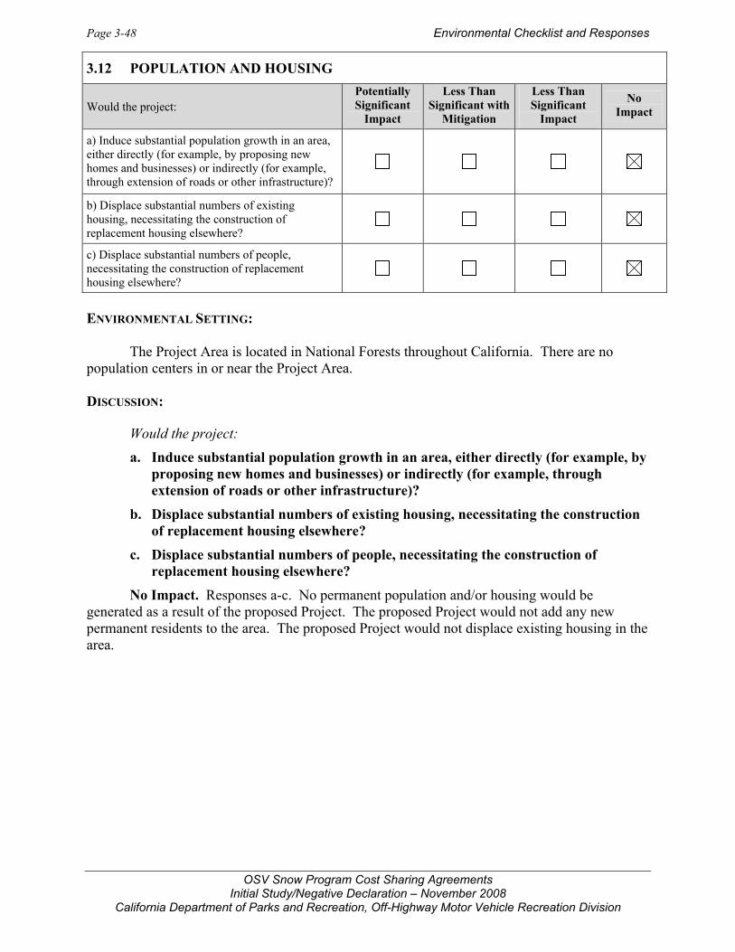
Page 3-48 Environmental Checklist and Responses
OSV Snow Program Cost Sharing Agreements Initial Study/Negative Declaration – November 2008
California Department of Parks and Recreation, Off-Highway Motor Vehicle Recreation Division
ENVIRONMENTAL SETTING: The Project Area is located in National Forests throughout California. There are no population centers in or near the Project Area. DISCUSSION:
Would the project:
a. Induce substantial population growth in an area, either directly (for example, by proposing new homes and businesses) or indirectly (for example, through extension of roads or other infrastructure)?
b. Displace substantial numbers of existing housing, necessitating the construction of replacement housing elsewhere?
c. Displace substantial numbers of people, necessitating the construction of replacement housing elsewhere?
No Impact. Responses a-c. No permanent population and/or housing would be generated as a result of the proposed Project. The proposed Project would not add any new permanent residents to the area. The proposed Project would not displace existing housing in the area.
3.12 POPULATION AND HOUSING
Would the project: Potentially Significant
Impact
Less Than Significant with
Mitigation
Less Than Significant
Impact
No Impact
a) Induce substantial population growth in an area, either directly (for example, by proposing new homes and businesses) or indirectly (for example, through extension of roads or other infrastructure)?
b) Displace substantial numbers of existing housing, necessitating the construction of replacement housing elsewhere?
c) Displace substantial numbers of people, necessitating the construction of replacement housing elsewhere?

Environmental Checklist and Responses Page 3-49
OSV Snow Program Cost Sharing Agreements Initial Study/Negative Declaration – November 2008
California Department of Parks and Recreation, Off-Highway Motor Vehicle Recreation Division
ENVIRONMENTAL SETTING: The Project Area largely comprises undeveloped areas in Natural Forests. Minor facilities exist in the form of roads, parking areas, trails, and restroom and warming hut structures. DISCUSSION:
a. Would the project result in substantial adverse physical impacts associated with the provision of new or physically altered governmental facilities, need for new or physically altered governmental facilities, the construction of which could cause significant environmental impacts, in order to maintain acceptable service ratios, response times or other performance objectives for any of the public services:
i) Fire protection?
No Impact. Fire protection in the National Forests is provided by USFS staff and the California Department of Forestry and Fire Protection. The Project would not require additional fire protection personnel or create increased fire risk. The project activities occur in wintertime in snow conditions when fire hazard is extremely low.
ii) Police protection?
No Impact. USFS provides police protection in National Forests as USFS Rangers are law enforcement officers. Law enforcement officers are used to enforce compliance with trail use designations and boundary restrictions. The Project would not expand the recreation trail system or increase its use levels requiring increased need for additional law enforcement officers.
3.13 PUBLIC SERVICES
Potentially Significant
Impact
Less Than Significant with
Mitigation
Less Than Significant
Impact
No Impact
a) Would the project result in substantial adverse physical impacts associated with the provision of new or physically altered governmental facilities, need for new or physically altered governmental facilities, the construction of which could cause significant environmental impacts, in order to maintain acceptable service ratios, response times or other performance objectives for any of the public services:
i) Fire protection?
ii) Police protection?
iii) Schools?
iv) Parks?
v) Other public facilities?

Page 3-50 Environmental Checklist and Responses
OSV Snow Program Cost Sharing Agreements Initial Study/Negative Declaration – November 2008
California Department of Parks and Recreation, Off-Highway Motor Vehicle Recreation Division
Law Enforcement Officers patrol the trail systems. Trail grooming helps delineate where it is legal to ride and helps to discourage incursions into protected wilderness areas. Grooming has the beneficial effect of hardening the snow surface to keep riders on safe snow conditions. This potentially reduces the number of search and rescue operations that may occur without the Project.
Groomed trails are predominantly used for snowmobiling, but the trails also accommodate cross-country skiing, snowshoeing, and other nonmotorized uses. Trails permitting motorized OSV use are designated by signage to avoid potential conflicts between trail users. Law Enforcement Officers patrol project trails for potential user conflicts between motorized and non-motorized uses. Since the Project represents a continuation of existing uses and does not involve new trails or a change in use of existing trails, no new potential conflicts would be created by the Project. No substantial user conflicts between the different user groups would occur as a result of the Project.
iii) Schools?
No Impact. The Project would not result in the need to alter existing schools or to construct new schools.
iv) Parks?
No Impact. The Project facilitates wintertime use of recreation trails in National Forests for OSV, cross-country skiing, and snowshoeing. The Project maintains an existing trail system. The Project would not generate increased demand for the development of new park facilities.
v) Other public facilities?
No Impact. The Project is contained entirely within the National Forest. No local governmental facilities related to other public facilities would be impacted by the proposed Project, nor would any new local governmental facilities need to be built as a result of the proposed Project.

Environmental Checklist and Responses Page 3-51
OSV Snow Program Cost Sharing Agreements Initial Study/Negative Declaration – November 2008
California Department of Parks and Recreation, Off-Highway Motor Vehicle Recreation Division
ENVIRONMENTAL SETTING: Groomed trails are predominately maintained for snowmobile or OSV use; however, ATV's users on a limited basis, Nordic skiers, and snowshoers can also use the parking areas and groomed trail systems. Within the National Forests OSV riders can traverse long distances to areas seldom visited in the winter to enjoy the views, picnic, or winter camp. The best time for snowmobiling occurs in late December through March after the snow has had the opportunity to set up and be groomed. Plowing of parking areas and trail grooming provide opportunities for all levels of snowmobile riding – easy groomed trail riding is best for beginners and the very difficult deep powder riding is available for experts. DISCUSSION:
a. Would the project increase the use of existing neighborhood and regional parks or other recreational facilities such that substantial physical deterioration of the facility would occur or be accelerated?
b. Does the project include recreational facilities or require the construction or expansion of recreational facilities which might have an adverse physical effect on the environment?
No Impact. Responses a-b. The proposed Project (plowing, grooming, restroom services, and garbage collection) facilitates the continuation of existing visitor use levels at the various trail site locations. The Project would not expand recreational facilities, create new facility demand, or generate an increased visitor use of these facilities above the current use levels.
Trail grooming provides recreational opportunity by providing safe packed snow conditions easy for OSV riding, skiing, and snowshoeing. Without grooming, there would be some reduction in trail use. Beginner riders would be less likely to use ungroomed trails because snowmobiles can get stuck in unpacked powder snow conditions. Experienced riders may continue to use the trail systems without the benefit of grooming. Trail grooming helps delineate where it is legal to ride and discourages incursions into protected wilderness areas.
3.14 RECREATION
Potentially Significant
Impact
Less Than Significant with
Mitigation
Less Than Significant
Impact
No Impact
a) Would the project increase the use of existing neighborhood and regional parks or other recreational facilities such that substantial physical deterioration of the facility would occur or be accelerated?
b) Does the project include recreational facilities or require the construction or expansion of recreational facilities which might have an adverse physical effect on the environment?

Page 3-52 Environmental Checklist and Responses
OSV Snow Program Cost Sharing Agreements Initial Study/Negative Declaration – November 2008
California Department of Parks and Recreation, Off-Highway Motor Vehicle Recreation Division
ENVIRONMENTAL SETTING: Regional access to the various trail sites in the Project Area are identified in Table 1 (see Project Description) and shown in Figures 2 through 7. Some trailheads are accessed directly from state highways while others are accessed from county roads. DISCUSSION:
Would the project:
a. Cause an increase in traffic which is substantial in relation to the existing traffic load and capacity of the street system (i.e., result in a substantial increase in either the number of vehicle trips, the volume to capacity ratio on roads, or congestion at intersections)?
Less than Significant Impact. The Project directly involves snow plowing and trail grooming, which does not generate increased traffic or otherwise adversely affect volume to capacity ratio on roads or congestion at intersections.
Indirectly, the Project would facilitate the continuation of existing vehicle trips associated with visitor use of the project trails. Visitation occurs throughout the week with heaviest use occurring on weekends and holidays. Local roads and highways providing access to the project
3.15 TRANSPORTATION/TRAFFIC
Would the project: Potentially Significant
Impact
Less Than Significant with
Mitigation
Less Than Significant
Impact
No Impact
a) Cause an increase in traffic which is substantial in relation to the existing traffic load and capacity of the street system (i.e., result in a substantial increase in either the number of vehicle trips, the volume to capacity ratio on roads, or congestion at intersections)?
b) Exceed, either individually or cumulatively, a level of service standard established by the county congestion management agency for designated roads or highways?
c) Result in a change in air traffic patterns, including either an increase in traffic levels or a change in location that results in substantial safety risks?
d) Substantially increase hazards due to a design feature (e.g., sharp curves or dangerous intersections) or incompatible uses (e.g., farm equipment)?
e) Result in inadequate emergency access?
f) Result in inadequate parking capacity?
g) Conflict with adopted policies, plans, or programs supporting alternative transportation (e.g., bus turnouts, bicycle racks)?

Environmental Checklist and Responses Page 3-53
OSV Snow Program Cost Sharing Agreements Initial Study/Negative Declaration – November 2008
California Department of Parks and Recreation, Off-Highway Motor Vehicle Recreation Division
sites would experience continued vehicle trips from project site visitors as an indirect effect of the Project. The Project would not expand recreational facilities or otherwise generate increased visitor trips beyond the levels already occurring. Visitor trips are be dispersed throughout the week with a majority of trips occurring on weekends during non-peak commute hours. The Project is therefore unlikely to generate a significant contribution to traffic congestion or peak flow conditions.
b. Exceed, either individually or cumulatively, a level of service standard established by the county congestion management agency for designated roads or highways?
No Impact. The Project would not generate new traffic over existing baseline levels or facilitate significant traffic during peak hour periods since the majority of recreational users visit the project sites on weekends. As a result the Project would not affect peak hour levels of service on local roads and highways.
c. Result in a change in air traffic patterns, including either an increase in traffic levels or a change in location that results in substantial safety risks?
No Impact. The proposed Project would not result in a change in air traffic patterns.
d. Substantially increase hazards due to a design feature (e.g., sharp curves or dangerous intersections) or incompatible uses (e.g., farm equipment)?
No Impact. The Project would not change the design of, or in any way affect, existing roads serving the Project Area. The project would not increase the number of vehicles accessing staging areas beyond historical levels and thus would not create a hazard at ingress/egress locations.
e. Result in inadequate emergency access?
No Impact. The Project does not propose any changes or alterations to the existing highway and road networks. Emergency access to project facilities would be unaffected by the Project.
f. Result in inadequate parking capacity?
No Impact. Snow plowing proposed by the Project facilitates use of existing trailhead parking areas. Without plowing, these parking areas would be inaccessible and unavailable for use.
g. Conflict with adopted policies, plans, or programs supporting alternative transportation (e.g., bus turnouts, bicycle racks)?
No Impact. The proposed Project would not conflict with adopted alternative transportation policies. The Project does not involve or otherwise affect alternative transportation such as bus turnouts or bicycle routes.

Page 3-54 Environmental Checklist and Responses
OSV Snow Program Cost Sharing Agreements Initial Study/Negative Declaration – November 2008
California Department of Parks and Recreation, Off-Highway Motor Vehicle Recreation Division
DISCUSSION:
Would the project:
a. Exceed wastewater treatment requirements of the applicable Regional Water Quality Control Board?
No Impact. The Project involves winter maintenance of trailhead facilities and the groomed trail system facilities in National Forests. The Project does not generate wastewater.
b. Require or result in the construction of new water or wastewater treatment facilities or expansion of existing facilities, the construction of which could cause significant environmental effects?
No Impact. There is no municipal wastewater service provided to the project sites. Restrooms provided at trailheads have vault toilets that are pumped out for off-site disposal. Construction of new or expanded water or wastewater treatment facilities is not required or proposed to serve the Project.
3.16 UTILITIES AND SERVICE SYSTEMS
Would the project: Potentially Significant
Impact
Less Than Significant with
Mitigation
Less Than Significant
Impact
No Impact
a) Exceed wastewater treatment requirements of the applicable Regional Water Quality Control Board?
b) Require or result in the construction of new water or wastewater treatment facilities or expansion of existing facilities, the construction of which could cause significant environmental effects?
c) Require or result in the construction of new storm water drainage facilities or expansion of existing facilities, the construction of which could cause significant environmental effects?
d) Have sufficient water supplies available to serve the project from existing entitlements and resources, or are new or expanded entitlements needed?
e) Result in a determination by the wastewater treatment provider which serves or may serve the project that it has adequate capacity to serve the project’s projected demand in addition to the provider’s existing commitments?
f) Be served by a landfill with sufficient permitted capacity to accommodate the project's solid waste disposal needs?
g) Comply with federal, state, and local statutes and regulations related to solid waste?

Environmental Checklist and Responses Page 3-55
OSV Snow Program Cost Sharing Agreements Initial Study/Negative Declaration – November 2008
California Department of Parks and Recreation, Off-Highway Motor Vehicle Recreation Division
c. Require or result in the construction of new stormwater drainage facilities or expansion of existing facilities, the construction of which could cause significant environmental effects?
No Impact. Project activities do not affect existing stormwater drainage or require construction of new stormwater drainage facilities.
d. Have sufficient water supplies available to serve the project from existing entitlements and resources, or are new or expanded entitlements needed?
No Impact. The Project does not create an increased demand on water supplies. Water resources are not affected by the Project.
e. Result in a determination by the wastewater treatment provider which serves or may serve the project that it has adequate capacity to serve the project’s projected demand in addition to the provider’s existing commitments?
No Impact. The Project does not involve construction of any restrooms. Project sites do have vault toilets that are periodically pumped out by maintenance staff and the contents disposed of off-site at a municipal disposal facility. The Project would not change the number of visitors using the project facilities and therefore would have not impact on wastewater generation or its treatment.
f. Be served by a landfill with sufficient permitted capacity to accommodate the project’s solid waste disposal needs?
No Impact. The Project includes garbage collection at existing trailhead facilities. The Project would not change the number of visitors using the project site facilities and therefore would not increase solid waste generation above levels already occurring in the National Forests on an annual basis.
g. Comply with federal, state, and local statutes and regulations related to solid waste?
No Impact. The amount of solid waste generated at project sites would not be increased beyond existing levels.

Page 3-56 Environmental Checklist and Responses
OSV Snow Program Cost Sharing Agreements Initial Study/Negative Declaration – November 2008
California Department of Parks and Recreation, Off-Highway Motor Vehicle Recreation Division
DISCUSSION:
a. Does the project have the potential to substantially degrade the quality of the environment, substantially reduce the habitat of a fish or wildlife species, cause a fish or wildlife population to drop below self-sustaining levels, threaten to eliminate a plant or animal community, substantially reduce the number or restrict the range of a rare or endangered plant or animal or eliminate important examples of the major periods of California history or prehistory?
Less Than Significant Impact. The grooming of project trails and subsequent use of the trails by motorized over snow vehicles (OSV) generates noise that could be disruptive to special-status birds and mammals. Potential impacts could include vehicle collision (although rare), restriction of range, disruption of courtship and breeding, abandonment of nests and dens, energy expenditures, and physiological stress. Considering the long-standing nature of grooming, plowing, and OSV recreation, any impacts to wildlife are part of existing baseline conditions under the approved recreational use of the National Forests governed by the Forest Plans. Concurrent with the OSV Snow Program, CDPR in conjunction with the USFS will ensure Management Actions are implemented that avoid or minimize conflicts with biological resources. The Project maintains designated trail system for winter use and does not alter the trail system or increase its subsequent use by recreation visitors. The Project would have less-than-significant impacts to all environmental factors listed in this section.
b. Does the project have impacts that are individually limited, but cumulatively considerable? (“Cumulatively considerable” means that the incremental effects of a project are considerable when viewed in connection with the effects of past projects, the effects of other current projects, and the effects of probable future projects)?
3.17 MANDATORY FINDINGS OF SIGNIFICANCE
Potentially Significant
Impact
Less Than Significant with
Mitigation
Less Than Significant
Impact
No Impact
a) Does the project have the potential to substantially degrade the quality of the environment, substantially reduce the habitat of a fish or wildlife species, cause a fish or wildlife population to drop below self-sustaining levels, threaten to eliminate a plant or animal community, substantially reduce the number or restrict the range of a rare or endangered plant or animal or eliminate important examples of the major periods of California history or prehistory?
b) Does the project have impacts that are individually limited, but cumulatively considerable? (“Cumulatively considerable” means the incremental effects of past projects, the effects of other current projects, and the effects of probably future projects as defined in Section 15130.)
c) Does the project have environmental effects which will cause substantial adverse effects on human beings, either directly or indirectly?

Environmental Checklist and Responses Page 3-57
OSV Snow Program Cost Sharing Agreements Initial Study/Negative Declaration – November 2008
California Department of Parks and Recreation, Off-Highway Motor Vehicle Recreation Division
Less than Significant Impact. The Project facilitates the continuation of recreational use of existing facilities. No new uses would be introduced to the Project Area; rather existing roads, parking areas, trailheads, restrooms and warming huts would be maintained to accommodate existing visitor use. The Project does not involve increased impacts to the environment. There are no cumulative impacts associated with the Project. The Project would not increase traffic levels or create new sources of pollution within the air basin or increase noise levels above historical levels.
c. Does the project have environmental effects which will cause substantial adverse effects on human beings, either directly or indirectly?
No Impact. The proposed Project would not have substantial adverse effects on human beings. The Project Area is within National Forest lands that are surrounded by sparsely populated areas. Neighboring communities would not be substantially impacted by this Project.


References Page 4-1
OSV Snow Program Cost Sharing Agreements Initial Study/Negative Declaration – November 2008
California Department of Parks and Recreation, Off-Highway Motor Vehicle Recreation Division
4.0 REFERENCES
4.1 BIBLIOGRAPHY
Barbour, Michael, Todd Keeler-Wolf, and Allan Schoenherr. 2007. Terrestrial Vegetation of California. Berkeley and Los Angeles: University of California Press.
Bunnell, Kevin D., Jerran T. Flinders and Michael L. Wolfe. 2006. Potential Impacts of Coyotes
and Snowmobiles on Lynx Conservation in the Intermountain West. Wildlife Society Bulletin. 34 (3): 828-838.
[CARB] California Air Resources Board, Staff Report: California 1990 Greenhouse Gas
Emission Level and 2020 Emission Limit, Public Release Date November 16, 2007. [CARB] California Air Resources Board. 1994. 1994 California State Implementation Plan. [CARB] California Air Resources Board. August 29, 2008. California State Implementation
Plan. http://www.arb.ca.gov/planning/sip/sip.htm [CARB] California Air Resources Board. August 27, 2008. Maps: California Map of Local Air
Districts Websites. http://www.arb.ca.gov/capcoa/dismap.htm [CARB] California Air Resources Board. September 8, 2008. Area Designation Maps.
http://www.arb.ca.gov/desig/adm/adm.htm [CARB] California Air Resources Board. October 24, 2008. Recommended approaches for
setting interim significance thresholds for greenhouse gases under the California Environmental Quality Act.
[CDPR] California Department of Parks and Recreation, Soil Conservation Guidelines/Standards
for Off-Highway Vehicle Recreation Management, November 14, 1991. California Department of Transportation. August 27, 2008. Scenic Highway Routes: Caltrans
Landscape Architecture Program. http://www.dot.ca.gov/hq/LandArch/scenic/cahisys.htm
California Department of Toxic Substance Control, Cortese List on Website
http://www.envirostor.dtsc.ca.gov/, August 24, 2007. California Natural Diversity Database. 2008. California Department of Fish and Game,
Biogeographic Data Branch. August update. California Native Plant Society. 2008. Inventory of Rare and Endangered Plants.
http://cnps.web.aplus.net/cgi-bin/inv/inventory.cgi Calflora: Information on California plants for education, research and conservation. [web
application]. 2008. Berkeley, California: The Calflora Database [a non-profit organization]. Available: http://www.calflora.org/. (Accessed: Sep 11, 2008)

Page 4-2 References
OSV Snow Program Cost Sharing Agreements Initial Study/Negative Declaration – November 2008
California Department of Parks and Recreation, Off-Highway Motor Vehicle Recreation Division
Eldorado National Forest Amador Ranger District. 2007-2008 Grooming Program and Policy.
Prepared as a Part of the MOU Between California And Nevada Snowmobile Association (CNSA) and Eldorado National Forest - Amador Ranger District.
International Snowmobile Manufacturers Association. October 6, 2008. Snowmobiling Facts: Sound. http://www.snowmobile.org/facts_sound.asp.
National Park Service. 2007. Winter Use Plans Final Environmental Impact Statement:
Yellowstone and Grand Teton National Parks, John D. Rockefeller, Jr. Memorial Parkway. Volumes 1 and 2.
National Scenic Byways Program. November 17, 2008. National Scenic Byways: California.
http://www.byways.org/explore/states/CA. NatureServe Explorer. 2008. http://www.natureserve.org/index.jsp [NSVPA] Northern Sacramento Valley Planning Area. 2006 Air Quality Attainment Plan. Northern Sierra Air Quality Management District Annual Air Monitoring Report 2005. Olliff, T., K. Legg, and B. Kaeding, editors. 1999. Effects of winter recreation on wildlife of the
Greater Yellowstone Area: a literature review and assessment. Report to the Greater Yellowstone Coordinating Committee. Yellowstone National Park, Wyoming.
Sawyer, John and Todd Keeler-Wolf. 1995. A Manual of California Vegetation. Sacramento:
California Native Plant Society. Science Daily. April 3, 2008. “Preliminary DNA Analysis of New California Wolverine Does
Not Match Historic Populations.” http://www.sciencedaily.com/releases/2008/04/080403125451.htm
U.S. Department of Interior (USDI). June 2004. Lower Klamath Basin Science Conference
Abstracts. http://www.usbr.gov/research/science-and-tech/conference/lowerklamath/rankingresults/abstractreport.cfm
U.S. Environmental Protection Agency. September 8, 2008. 8-hour Ozone Non-attainment State
Map. http://www.epa.gov/air/oaqps/greenbk/ca8.html U.S. Department of Agriculture (USDA) Forest Service. January 2001. Sierra Nevada Forest
Plan Amendment Final Environmental Impact Statement. Forest Service. Pacific Southwest Region, Sacramento, CA.
U.S. Department of Agriculture (USDA) Forest Service. 2004. Sierra Nevada Forest Plan
(Framework) Amendment, Final Supplemental Environmental Impact Statement. http://www.fs.fed.us/r5/snfpa/final-seis/
U.S. Department of Agriculture (USDA) Forest Service. September 13, 2007. Eldorado National
Forest 2008 OHV Grant Application WHPP/HMP. OHV Form F.

References Page 4-3
OSV Snow Program Cost Sharing Agreements Initial Study/Negative Declaration – November 2008
California Department of Parks and Recreation, Off-Highway Motor Vehicle Recreation Division
U.S. Department of Agriculture (USDA) Forest Service. September 11, 2007. Inyo National Forest 2008 OHV Grant and Cooperative Agreement Application. Wildlife Habitat Protection Program (WHPP)/ Habitat Management Program (HMP).
U.S. Department of Agriculture (USDA) Forest Service. September 10, 2007. Tahoe National
Forest 2008 OHV Grant Application WHPP/HMP. U.S. Department of Agriculture (USDA) Forest Service. June 26, 2003. Tahoe National Forest
2003/2004 Summer OHV and Winter OSV Grant Application. Wildlife Habitat Protection Program (WHPP)/ Wildlife Habitat Management Program (HMP). Foresthill Ranger District.
U.S. Department of Agriculture (USDA) Forest Service. June 26, 2003. Modoc National Forest
2003/2004 OSV O&M Grant Application. Wildlife Habitat Protection Program (WHPP)/ Wildlife Habitat Management Program (HMP). Doublehead Ranger District.
U.S. Department of Agriculture (USDA) Forest Service. June 25, 2003. Klamath National Forest
2003/2004 OSV Area Management Grant Application. Wildlife Habitat Protection Program (WHPP)/ Wildlife, Fish, and Plants Habitat Management Program (HMP).
U.S. Department of Agriculture (USDA) Forest Service. May 16, 2003. Lassen National Forest
OSV O&M Grant Application. Wildlife Habitat Protection Program (WHPP)/ Wildlife, Fish, and Plants Habitat Management Program (HMP).
U.S. Department of Agriculture (USDA) Forest Service. May 15, 2003. Plumas National Forest
2004 Winter O&M Grant Application. Wildlife Habitat Protection Program (WHPP)/ Wildlife, Fish, and Plants Habitat Management Program (HMP).
U.S. Department of Agriculture (USDA) Forest Service. May 15, 2003. Stanislaus National
Forest 2004 OSV O&M Grant Application. Wildlife, Fish, and Plants Habitat Management Program (HMP).
U.S. Department of Agriculture (USDA) Forest Service. May 14, 2003. Sequoia National Forest
2004 OSV O&M Grant Application. Wildlife Habitat Protection Program (WHPP)/ Wildlife, Fish, and Plants Habitat Management Program (HMP).
U.S. Department of Agriculture (USDA) Forest Service. May 13, 2003. Shasta-Trinity National
Forest 2004 OSV O&M Grant Application. Wildlife Habitat Protection Program (WHPP)/ Wildlife, Fish, and Plants Habitat Management Program (HMP).
U.S. Department of Agriculture (USDA) Forest Service. May 12, 2003. Sierra National Forest.
2003/2004 OSV O&M Grant Application. Wildlife Habitat Protection Program (WHPP)/ Habitat Management Program (HMP).
U.S. Department of Agriculture (USDA) Forest Service. May 7, 2003. Inyo National Forest.
2003/2004 OSV O&M Grant Application. Wildlife Habitat Protection Program (WHPP)/ Habitat Management Program (HMP).
Page 4-4 References
OSV Snow Program Cost Sharing Agreements Initial Study/Negative Declaration – November 2008
California Department of Parks and Recreation, Off-Highway Motor Vehicle Recreation Division
Zielinski, William J., Keith M. Slauson and Ann E. Bowles. 2007. The Effect of Off-Highway Vehicle Use on the American Marten in California, USA. Final Report to the USDA Forest Service, Pacific Southwest Region, and California Department of Parks and Recreation, Off-Highway Motor Vehicle Recreation Division. Sacramento.
4.2 PERSONS CONSULTED
California Department of Parks and Recreation Terry Harper, OHMVR Division U.S. Forest Service, Pacific Southwest Region Regional Office, Diana Craig, Regional Wildlife Ecologist Regional Office, Kathleen Mick, Regional Trails Program Manager Eldorado NF, Roger Ross, Amador Ranger District Inyo NF, Lisa Walker, OSV Program Manager Inyo NF, Rick LaBorde, Wilderness Steward Klamath NF, Jim Stout, Resource Officer Lassen NF, Christopher O’brien, Public Services Staff Officer Modoc NF, Jessie Berner, Forest Recreation Officer Sequoia NF, Chris Sanders, Assistant Forest Recreation Officer Shasta-Trinity NF, Ed Hatakeda, Recreation Forester Plumas NF, Susan Barron, Forest IWEB/SUDS Coordinator Sierra NF, Susan Berkindine, Assistant Recreation Officer Stanislaus NF, Sue Warren, Route Designation ID Team Leader Tahoe NF, David Michael, Trails and OHV Program Manager Butte County Public Works Cindy Anderson, Administrative Analyst Plumas County Public Works Marty Byrne, Assistant Director Sierra County Public Works Van Maddox, Auditor Siskiyou County APCD Elden Beck, Assistant Air Pollution Control Officer Lassen County APCD Jim Donnelly, Air Pollution Control Officer Northern Sierra AQMD Sam Longmire, Assistant Air Pollution Control Officer, Great Basin Unified APCD Duane Ono, Deputy Assistant Air Pollution Control Officer Tehama County AQMD Russ Mull, Air Pollution Control Officer

Report Preparers Page 5-1
OSV Snow Program Cost Sharing Agreements Initial Study/Negative Declaration – November 2008
California Department of Parks and Recreation, Off-Highway Motor Vehicle Recreation Division
5.0 REPORT PREPARERS TRA Environmental Sciences, Inc. 545 Middlefield Road, Suite 200 Menlo Park, California 94025 Tel: 650-327-0429 Fax: 650-327-4024 Tom Reid, Principal Paula Hartman, Program Manager Kate Werner, Project Manager Victoria Harris, Senior Associate Virginia Justus, Associate Brian Williams, Associate Autumn Meisel, Biologist


OSV Snow Program Cost Sharing Agreements Initial Study/Negative Declaration – November 2008
California Department of Parks and Recreation, Off-Highway Motor Vehicle Recreation Division
OSV SNOW PROGRAM COST SHARING AGREEMENTS INITIAL STUDY
FIGURES

1B
6B
9B9C
7B7C
7A
7D
2A
1A
6A
4A4D
4F4E4C
4B
5A5B3B3A
8A
10C
11C
11A
9A 9D
6C
10B 10A
11B
Modoc NF
Klamath NF
Trinity NFShasta NF
Lassen NF
Plumas NF
Tahoe NF
Eldorado NF
Stanislaus NF
Sierra NFInyo NF
Sequoia NF
San Jose Metro AreaSan Jose Metro Area
San FranciscoSan Francisco
SacramentoSacramento
5
80
101
50
5
99
Basemap: ESRI Streetmap, August 2008Map by TRA, October 2008
National Forest CSA Project Locations1. Eldorado NF Silver Bear (1A), Iron Mtn (1B)2. Inyo NF Mammoth/June Lake (2A)3. Klamath NF Deer Mountain (3A), Four Corners (3B)4. Lassen NF Jonesville (4A), Ashpan (4B), Bogard (4C), Fredonyer (4D), Morgan Summit (4E), Sw ain Mountain (4F) 5. Modoc NF Medicine Lake (5A), Doorknob (5B)6. Plumas NF Bucks Lake (6A), La Porte (6B), Gold Lake (6C)7. Sequioa NF Westside OSV/Sugarloaf (7A), Eastside OSV/Holby (7B), Quaking Aspen (7C), Big Meadow /Quail Flat (7D)8. Shasta-Trinity NF Pilgrim Creek (8A)9. Sierra NF Huntington Lake (9A), Kaiser Pass (9B), Tamarack Ridge (9C), Coyote (9D)10. Stanislaus NF Lake Alpine (10A), Spicer (10B) and Hw y 308 (10C)11. Tahoe NF Little Truckee (11A), Bassetts (11B), China Wall (11C)
Figure 1. Regional Location
CSA Project Location0 30 60
Miles

4
4
108
88
89
108
108
49
Lake TahoeLake Tahoe
L a k e T a h o e
49
49
5050State Line
State Line
N E V A D AN E V A D A
395
395
88
89
PioneerJackson
Dardanelle
Strawberry
Placerville
Bear Valley
S p i c e r ( 1 0 B )S p i c e r ( 1 0 B )
I r o n M t n ( 1 B )I r o n M t n ( 1 B )
H w y 1 0 8 ( 1 0 C )H w y 1 0 8 ( 1 0 C )
S i l v e r B e a r ( 1 A )S i l v e r B e a r ( 1 A )
L a k e A l p i n e ( 1 0 A )L a k e A l p i n e ( 1 0 A )Ridge
Omo RanchFiddletown
Lotus
Shake Ridge
Mormon Emigrant
Ice House
Latrobe
Shing
le
Day
Pioneer
Twin Lakes
Mosquito
Tonzi
Sly Park
89
Paloma
Hunt
Green Valley
Big Hill
Fricot City
Jesus Maria
26
9n 45
Sand Ridge
Valle
y
Pool
Statio
n
Mo unt Auku m
Rock Creek
Shenandoah
Mountain Ranch
Stoney Creek
P leasant ValleyNewtownMother Lode
Holly
South
12
Peavine Ridge
Cal dor
Johnson
P hoenix Lake
Murphys Grade
Capps CrossingGrizzly Flat
D
Pony Express
Emigrant
Tuolumne
Meder
Bal d Moun tain
Redhi
ll
Ponderosa
Main
Jamest
own
Moran
Lily Gap
Silver Fork
Marshall
Forni TolerDurockRidgeway
Seco
4th Crossing
Airport
16
Fairp
lay
Wrights Lake
89Fiddletown
Tuolu
mne
Ridge
Valle
y
HuntPool Station
Rock Creek
S t a n i s l a u s N F
E l d o r a d o N F
Sources: USDA Forest Service (Stanislaus NF, May 2007; Eldorado NF, March 2006)Basemap: ESRI Streetmap, 2008Map by TRA, October 2008
National Forests
Over-Snow Vehicle (OSV) Trails
CSA Project Location
0 105 Miles
Figure 2. Eldorado and Stanislaus National ForestsProject Sites
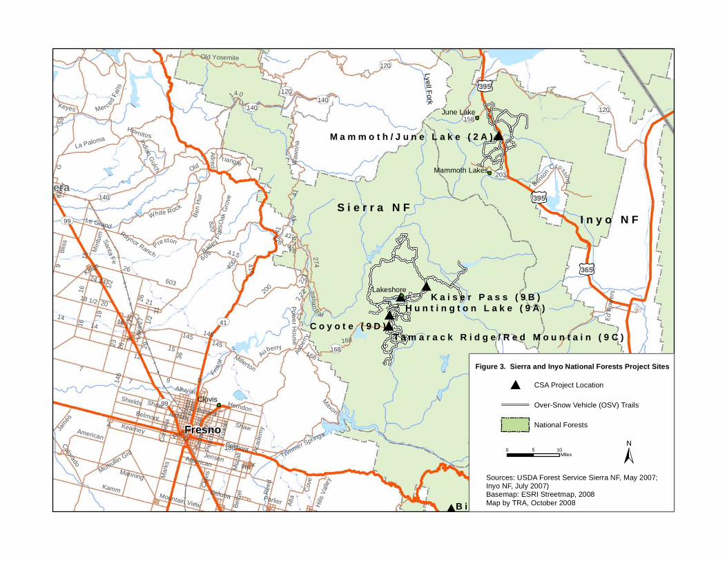
395
365
120
140120
168
41
140 120
167
203
Lyell Fork
158
395
180
99
Fresno
99
140Madera
C o y o t e ( 9 D )
M a m m o t h / J u n e L a k e ( 2 A )
B i g M e a d o w / Q u a i l F l a t ( 7 D )
Clovis
Lakeshore
June Lake
Mammoth Lakes
127
9
60 0
Manning
15
26
2319
14
200
36
Kamm
Marks Mc
call
1st
415
Shaw
Olive
G
18 1/2
16
Ashlan
222
21
274
Kearney
Ben H
ur
Reed
Hornitos
American
Belmont
Shields
1/2
Acad
emy
Ceda
r
White Rock
Jensen
Friant
29
Le Grand
Herndon
603
Palm
Old
West
La Paloma
17
Alta
Fresno
Fowle
r
Santa Fe
T riangle
Merced Fa
l ls
Trimmer Springs
Auberry 168
Colorado K
221
Bliss
Keyes
20
James
E
Preston
145
27
Allred
Bethe
l
O
Cove
24
Mintu
rn
Ital ian B ar
Mountain View Hills V
alley
Clovis
A
416
Indian Gulch
Bullard
140
Maxon
Peac
h
Mcmullin Grd
Oak G
rove
Lake
426
Bailey Flat
s400
25
9th
41
Kibby
Millerton
Benton Crossing
820
Power House
Wawo
na
Alluvial
Old Yosemite
31Co
rnelia
Raynor Ranch
Parlier
Ed Po
wers
Dinuba
Kings
59
26
Belmont
9
41
26
168
16 1/2
15
7145
1614
9
145
24
426
41
426
ShawAmerican
145
Aube
rryK a i s e r P a s s ( 9 B )
H u n t i n g t o n L a k e ( 9 A )
T a m a r a c k R i d g e / R e d M o u n t a i n ( 9 C )
S i e r r a N FI n y o N F
Figure 3. Sierra and Inyo National Forests Project Sites
Sources: USDA Forest Service Sierra NF, May 2007;Inyo NF, July 2007)Basemap: ESRI Streetmap, 2008Map by TRA, October 2008
0 105 Miles
National Forests
Over-Snow Vehicle (OSV) Trails
CSA Project Location

139
139
89
Siskiyou
97
975
89
97
139
97
299299
97 State Line
P i l g r i m ( 8 A )
D o o r k n o b ( 5 B )F o u r C o r n e r s ( 3 B )
M e d i c i n e L a k e ( 5 A )
D e e r M o u n t a i n ( 3 A )
McCloud
MacdoelTulelake
Tionesta
Hill
87
Old
Day
Davis
93
Louie
Big Sp
rings
Ol d Stage
114
Old S
tate
Mayfie ld
Red Rock
West
Ager
Fore
st
Robison
Harpold
10
Harry Cas h
Whitehorse
Looko
ut Ha
ckam
ore
Mcarthur
Clear Lake Reservoir
Military Pass
Oberlin
Widow Valley
111
120
Ager Beswick
Sca rface
Tena nt
Clear Lake
89
Dorris Brownell
Easy
113
Centerville
Harris
Spri
ngs
Lower K lam ath Lake
124
Mayfi
eld C
aveDu
nsmuir
Usfs
45 05
Acomia
6t h
State Line
Ball Mountain L itt le Shasta
Willow Creek
College
Usfs 44 01
Castle Creek
Mott
3
Lake
Lyons
Edgewood
Old Camp Two
Military
Willow Creek
Old
Ager
Forest
HillMil itary Pass
Ager
111
Mcarthur
K l a m a t h N F
M o d o c N F
S h a s t a -T r i n i t y N F
S h a s t a -T r i n i t y N F
O R E G O NO R E G O N
Sources: USDA Forest Service (Modoc NF, May 2007;Shasta-Trinity NF, October 2007; Klamath NF, June 2007)Basemap: ESRI Streetmap, 2008Map by TRA, October 2008
Over-Snow Vehicle (OSV) Trails
CSA Project Location
National Forests
0 105Miles
Figure 4. Klamath, Modoc, and Shasta-Trinity National Forests Project Sites

36
395
70
89
89
44
139
395
70
99
70
99
36
89
8955
5
Lake Almanor
Plumas
99
32
32
B o g a r d ( 4 C )
A s h p a n ( 4 B )
F r e d o n y e r ( 4 D )
B u c k s L a k e ( 6 A )
J o n e s v i l l e ( 4 A )
M o r g a n S u m m i t ( 4 E ) S w a i n M o u n t a i n ( 4 F )
Quincy
Redding
Red Bluff
P l u m a s N F
L a s s e n N F
Sources: USDA Forest Service (Lassen NF, May 2007;Plumas NF, July 2006)Basemap: ESRI Streetmap, 2008Map by TRA, October 2008
National Forests
Over-Snow Vehicle (OSV) Trails
CSA Project Location
0 105 Miles
Figure 5. Lassen and Plumas National Forests Project Sites

Plumas
80
49
70
Red R
ock
395
20
49
80
20
20
395
445
341431267
Henness PassHenness PassHenness Pass
395
Lake Tahoe
Kirma
nR e n o
89
89
89
49
State
State
Line
State
State
State
Plumas
70
49
State
Line
L a P o r t e ( 6 B )
G o l d L a k e ( 6 C )
B u c k s L a k e ( 6 A )
C h i n a W a l l ( 1 1 C )
L i t t l e T r u c k e e S u m m i t ( 1 1 A )
Quincy
Truckee
Graeagle
Foresthill
Sierraville
4th
Foresthil l
R idge
A
A15
Concow
Henness Pass
Wise
Dyson
La Porte
Wentworth Springs
Smithneck
Lotus
Mill
Bucks Lake
Forbestown
Mosquito
Scott
2nd
Fir
Green V alley
Mccourtn
ey
Rough
Hack
staff
Grizzly
Tyler Foote
Placer
Hills
Spenceville
M a rysville
Pleasant V
alley
Eastlake
Dixie
Prater
89
King
7th
Frenc
htown
Cons tantia
Willo
w Glen
Garni
er
Beckwourth Taylorsville
Qu
incy La Porte
Neil
Harrie
t
Soda Springs
Bloomfiel
d Graniteville
Mount Vernon
Edmond
s
A24
Roop
Rock Creek
Lime Kiln
Johnson
Genesee
D
Main
Greenwood
Dog Valley
Sierra
Valle
y
Rattle
snak
e
Verdi
Ramsey Ctf
Caribou
Bear Creek
Ridgo
Nye
Doyle
Old Truckee
Red Dog
Camp Creek
Airport
Scott
La Po
rte
La Porte
Foresthill
Ridge
89
89
Mill
Reno Tahoe International
B a s s e t t s ( 1 1 B )
T a h o e N F
P l u m a s N F
Sources: USDA Forest Service (Tahoe NF, March 2005; Plumas NF, July 2006)Basemap: ESRI Streetmap, 2008Map by TRA, October 2008
CSA Project Location
0 105 Miles
National Forests
Over-Snow Vehicle (OSV) Trails
N E V A D AN E V A D A
Figure 6. Plumas and Tahoe National ForestsProject Sites

395
395
65
198
198
99
198
180180
190
155
OwensLake
Q u a k i n g A s p e n ( 7 C )E a s t s i d e O S V / H o l b y ( 7 B )
B i g M e a d o w / Q u a i l F l a t ( 7 D )
W e s t s i d e O S V / S u g a r l o a f ( 7 A )
Visalia
PortervilleSpringville
Independence19
2
80
6th
Sierra
384
J 256
56
152 196
Lerdo
ManningK
Mcca
ll
Gr anite
112
Reed
156
328
I
8
Elmo
Pond
Bethe
l Alta
Dry C
reek
176
Rose
Belmont
41688
Terra Bella
Houston
Central
Sherwood
144
Caldwell
Plano
Old Stage Coach
216
Main
120
Merced
American
Goshen
Cairn
sBoy d
Cove
Kimberlina
F
Whitney Portal320
Visalia
Hills V
alley
O
184
Myer
276
L
Famoso
Portervil
le
190
Spruc
e
Brown
124
Trimmer Springs
Dinuba68
12
236
Famoso Woody
Owenyo Lone Pine
Kamm
104
Yokohl Valley
136
178
155
128
Famoso
232
Millwoo
d
11th
Turner
Floral
White River
El Monte10
8
190
56
196 216
192
8
136
196
416
144
Bethe
l
190
152S e q u o i a N F
Sources: USDA Forest Service (Sequoia NF, May 2007)Basemap: ESRI Streetmap, 2008Map by TRA, October 2008
CSA Project Location
National Forests
0 105Miles
Over-Snow Vehicle (OSV) Trails
Figure 7. Sequoia National Forest Project Sites

OSV Snow Program Cost Sharing Agreements IS/ND APPENDIX A AIR QUALITY CALCULATIONS
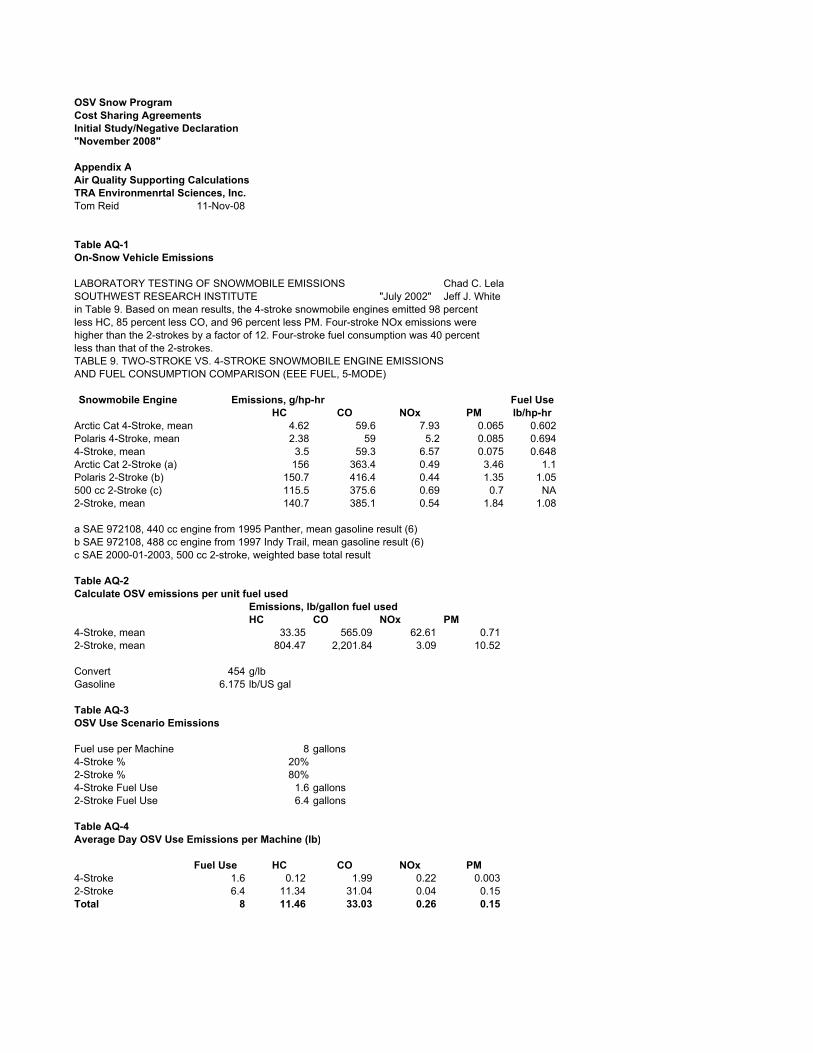
OSV Snow ProgramCost Sharing AgreementsInitial Study/Negative Declaration"November 2008"
Appendix AAir Quality Supporting CalculationsTRA Environmenrtal Sciences, Inc.Tom Reid 11-Nov-08
Table AQ-1On-Snow Vehicle Emissions
LABORATORY TESTING OF SNOWMOBILE EMISSIONS Chad C. LelaSOUTHWEST RESEARCH INSTITUTE "July 2002" Jeff J. Whitein Table 9. Based on mean results, the 4-stroke snowmobile engines emitted 98 percentless HC, 85 percent less CO, and 96 percent less PM. Four-stroke NOx emissions werehigher than the 2-strokes by a factor of 12. Four-stroke fuel consumption was 40 percentless than that of the 2-strokes.TABLE 9. TWO-STROKE VS. 4-STROKE SNOWMOBILE ENGINE EMISSIONSAND FUEL CONSUMPTION COMPARISON (EEE FUEL, 5-MODE)
Snowmobile Engine Emissions, g/hp-hr Fuel UseHC CO NOx PM lb/hp-hr
Arctic Cat 4-Stroke, mean 4.62 59.6 7.93 0.065 0.602Polaris 4-Stroke, mean 2.38 59 5.2 0.085 0.6944-Stroke, mean 3.5 59.3 6.57 0.075 0.648Arctic Cat 2-Stroke (a) 156 363.4 0.49 3.46 1.1Polaris 2-Stroke (b) 150.7 416.4 0.44 1.35 1.05500 cc 2-Stroke (c) 115.5 375.6 0.69 0.7 NA2-Stroke, mean 140.7 385.1 0.54 1.84 1.08
a SAE 972108, 440 cc engine from 1995 Panther, mean gasoline result (6)b SAE 972108, 488 cc engine from 1997 Indy Trail, mean gasoline result (6)c SAE 2000-01-2003, 500 cc 2-stroke, weighted base total result
Table AQ-2Calculate OSV emissions per unit fuel used
Emissions, lb/gallon fuel usedHC CO NOx PM
4-Stroke, mean 33.35 565.09 62.61 0.71 2-Stroke, mean 804.47 2,201.84 3.09 10.52
Convert 454 g/lbGasoline 6.175 lb/US gal
Table AQ-3OSV Use Scenario Emissions
Fuel use per Machine 8 gallons4-Stroke % 20%2-Stroke % 80%4-Stroke Fuel Use 1.6 gallons2-Stroke Fuel Use 6.4 gallons
Table AQ-4Average Day OSV Use Emissions per Machine (lb)
Fuel Use HC CO NOx PM4-Stroke 1.6 0.12 1.99 0.22 0.003 2-Stroke 6.4 11.34 31.04 0.04 0.15 Total 8 11.46 33.03 0.26 0.15

Table AQ-5OSV Use by Air District
Trailhead VehicleOSV Use
days
Air DistrictNational Forest Location Capacity Max Day Season
Siskiyou County APCD Klamath Deer Mountain and Four Corners 25 50 1,922 Modoc Medicine Lake and Doorknob 20 40 1,537 Shasta-Trinity Pilgrim Creek 20 40 1,537
Lassen County APCD Lassen Bogard, Frednoyer, and Swain Mountain 215 430 16,525 Shasta County APCD Lassen Ashpan 20 40 1,537 Tehama County APCD Lassen Morgan Summit 30 60 2,306 Butte County AQMD Lassen Jonesville 30 60 2,306 Northern Sierra AQMD Plumas Bucks Lake, La Porte, and Gold Lake 100 200 7,686
Tahoe Little Truckee Summit and Bassetts 60 120 4,612 Placer County APCD Tahoe China Wall 25 50 1,922 El Dorado County APCD Eldorado Iron Mountain and Silver Bear 35 70 2,690 Great Basin Unified APCD Inyo Mammoth Lakes and June Lake 12 24 922
Stanislaus Lake Alpine, Spicer Reservoir, and Hwy 108 250 500 19,215 San Joaquin Valley Unified Sierra Huntington Lake, Kaiser Road Pass and Tamarack Ridge 127 254 9,761
Sequoia Westside/Sugarloaf, Eastside/Holby, 100 200 7,686 Quaking Aspen, and Meadow/Quail Flat
Total 1,069 2,138 82,163 Notes:Max Day is a Weekend Day/Holiday. Assume maximum capacity visitation and 2 OSV per vehicleSeason is from mid-December through March (14 weeks): 33 weekend/holidays at 90% and 65 weekdays at 20% use.Assume 1.8 OSV per average vehicle parked.Source: Calculations TRA; Data, OHMVR, Terry Harper Sr.
Table AQ-6OSV Max Day Use Emissions (lb)
Max Day Use Emissions (lb)
Air DistrictNational Forest Trailheads Max Day Use
Fuel Use (gal) HC CO NOx PM
Siskiyou APCD Klamath 1 50 400 573 1,652 13.2 7.5 Modoc 1 40 320 458 1,321 10.6 6.0 Shasta Trinity 1 40 320 458 1,321 10.6 6.0
Lassen County APCD Lassen 3 430 3,440 4,927 14,203 113.6 64.9 Shasta County AQMD Lassen 1 40 320 458 1,321 10.6 6.0 Tehama County AQMD Lassen 1 60 480 687 1,982 15.9 9.0 Butte County APCD Lassen 1 60 480 687 1,982 15.9 9.0 Northern Sierra AQMD Plumas 3 200 1,600 2,292 6,606 52.8 30.2
Tahoe 2 120 960 1,375 3,964 31.7 18.1 Placer County APCD Tahoe 1 50 400 573 1,652 13.2 7.5 El Dorado County APCD Eldorado 1 70 560 802 2,312 18.5 10.6 Great Basin Unified APCD Inyo 1 24 192 275 793 6.3 3.6
Stanislaus 3 500 4,000 5,729 16,515 132.1 75.4 San Joaquin Valley Unified Sierra 3 254 2,032 2,910 8,390 67.1 38.3
Sequoia 4 200 1,600 2,292 6,606 52.8 30.2
Total 27 2,138 17,104 24,497 70,620 565 322

Table AQ-7OSV Season Use Emissions (tons)
Air District National ForestTrail heads Season
Fuel Use (gal) HC CO NOx PM
Siskiyou APCD Klamath 1 1,922 15,372 11.0 31.7 0.3 0.1 Modoc 1 1,537 12,298 8.8 25.4 0.2 0.1 Shasta Trinity 1 1,537 12,298 8.8 25.4 0.2 0.1
Lassen County APCD Lassen 3 16,525 132,199 94.7 272.9 2.2 1.2 Shasta County AQMD Lassen 1 1,537 12,298 8.8 25.4 0.2 0.1 Tehama County AQMD Lassen 1 2,306 18,446 13.2 38.1 0.3 0.2 Butte County APCD Lassen 1 2,306 18,446 13.2 38.1 0.3 0.2 Northern Sierra AQMD Plumas 3 7,686 61,488 44.0 126.9 1.0 0.6
Tahoe 2 4,612 36,893 26.4 76.2 0.6 0.3 Placer County APCD Tahoe 1 1,922 15,372 11.0 31.7 0.3 0.1 El Dorado County APCD Eldorado 1 2,690 21,521 15.4 44.4 0.4 0.2 Great Basin Unified APCDInyo 1 922 7,379 5.3 15.2 0.1 0.1
Stanislaus 3 19,215 153,720 110.1 317.3 2.5 1.4 San Joaquin Valley UnifiedSierra 3 9,761 78,090 55.9 161.2 1.3 0.7
Sequoia 4 7,686 61,488 44.0 126.9 1.0 0.6
Total 27 82,163 657,307 471 1,357 10.9 6.2
Season 98 days/year 39% average us 38.4 times max day
Table AQ-8Recreational User Transportation
Season OSV 82,163 Season OSV per vehicle 1.8Vehicles per season 45,646 Trip ends per visitor-day 1.2 Assume some multi-visit days per tripSeason Trip Ends 54,776 Average trip length 85 mi/trip endSeason mileage 4,655,923 milesHaul vehicle fuel use rate 12 mi/galTransport Fuel Use 387,994 gallons
Table AQ-9Grooming Equipment Use
National Forest Project LocationGroom
Trail (mi)Snow cat
Hours Road (mi)
Plow Trail
heads
Snow plow
Hours Total
Annual Max Day YearMax Day Hours
Eldorado Silver Bear and Iron Mountain 80 200 10 0 1 104 2 304Inyo Mammoth / June Lake 100 450 9 0 1 104 2 554Klamath Deer Mountain and Four Corners 135 225 12 18 2 151 8 376Lassen Ashpan, Bogard, Fredonyer, Morgan Summ 332 281 12 0 4 416 2 697Lassen (Butte County) Jonesville 67 180 6 7 1 80 4 260Modoc Medicine Lake and Doorknob 52 0 13 1 109 8 109Plumas Bucks Lake, La Porte, and Gold Lake 182 566 12 0 0 0 0 566Plumas (Plumas County) Big Creek, Bucks Lake, and Gold Lake 0 0 0 11 3 485 8 485Sequoia Westside OSV/Sugarloaf, Eastside OSV/H 157 488 12 0 3 312 2 800Shasta-Trinity Pilgrim Creek 89 245 13 0 1 104 2 349Sierra Huntington Lake, Kaiser Pass, and Tamara 209 191 12 0 3 312 2 503Stanislaus Lake Alpine, Spicer, and Hwy 108 71 466 12 0 3 312 2 778Tahoe China Wall 50 701 10 0 1 104 2 805Tahoe (Sierra County) Little Truckee Summit and Bassetts 197 985 12 13 2 8 8 993
Total 1721 4978 62 26 2601 7579

Table AQ-10Grooming Equipment Fuel Use
Total Hours 7579 Hours per yearFuel use rate 4.70 gallons per hourFuel Use 35,633 gallons per year
Fuel Use Factors191 hours29 days groomed
924 miles 4.8 miles per hour 898 gallons fuel
0.97 gallons per mile4.70 gallons per hour
Source: Sierra National Forest
Table AQ-11Greenhouse Gasses, all sources
Fuel Use GHG
Source FuelGHG
kg/gal gallons MT CO2Grooming Equipment Diesel 10.2 35,633 362 OSV Use Gas 8.8 657,307 5,784 User Transportation Gas 8.8 387,994 3,414
Total 1,080,933 9,561
CO2 8.8 kg/gal gasoline 40 CFR 600.113-7810.2 kg/gal diesel
Table AQ-12Typial Day and Season Grooming Activity Scenario
Use ScenarioOne Machine Two Machines
Active ActiveMax day Annual Max day Annual
Fuel Use gal 66 900 120 2,140 Work kw-hr 920 12,546 1,673 29,832
Tier 1NOx factor g/kw-hr 9.2 9.2 9.2 9.2 NOx emissions g 8,464 115,423 15,390 274,451 NOx emissions lb 18.6 254.0 33.9 603.9
PM10 factor g/kw-hr 0.54 0.54 0.54 0.54 PM10 emissions g 497 6,775 903 16,109 PM10 emissions lb 1.1 14.9 2.0 35.4
Tier 2NOx factor g/kw-hr 6.6 6.6 6.6 6.6 NOx emissions g 6,072 82,804 11,040 196,889 NOx emissions lb 13.4 182.2 24.3 433.2
PM10 factor g/kw-hr 0.20 0.20 0.20 0.20 PM10 emissions g 184 2,509 335 5,966 PM10 emissions lb 0.4 5.5 0.7 13.1
Conversion 13.94 kw-hr/galBased on typical consumption 0.38 lb/bhp-hr;Diesel density 7.1 lb/gal; conversion 0.746 kw/bhp For engines between 130 kW (174 hp) and 225 kW (302 hp), Tier 1 applies 1996 to 2002, Tier 2 applies 2003 to 2005For engines between 225 kW (302 hp) and 450 kW (603 hp), Tier 1 applies 1996 to 2001, Tier 2 applies 2002 to 2005Emissions factor, 98% of NMHC + NOx is NOx

OSV Snow Program Cost Sharing Agreements IS/ND APPENDIX B SPECIAL-STATUS SPECIES LIST

Appendix B: Special Status Species List
OSV Snow Program Cost Sharing Agreements 1
Table B-1. Special-Status Species Potentially Occurring or Known to Occur in the Project Area
Species Listing Status1
Habitat Forests Where Occurs/May
Occur ANIMALS
Bald eagle (Haliaeetus leucocephalus)
SE, SP Preferentially roosts in conifers or other sheltered sites in winter in some areas; typically selects the larger, more accessible trees. Wintering areas are commonly associated with open water, though in some areas eagles use habitats with little or no open water if other food resources (e.g., rabbit or deer carrion) are readily available.
Inyo, Lassen, Modoc, Plumas, Sequoia, Shasta-Trinity, Sierra, Stanislaus, Tahoe
Northern goshawk (Accipiter gentilis)
FSS, CSSC Mature coniferous forests and riparian aspen stringers serve as both nesting and foraging habitat. Nests in a wide variety of forest types including deciduous, coniferous, and mixed forests. Characteristically nests in coniferous forests including those dominated by ponderosa pine, lodgepole pine, or in mixed forests dominated by various coniferous species including fir, Douglas-fir, cedar, hemlock, spruce, and larch.
Eldorado, Inyo, Klamath, Lassen, Modoc, Plumas, Shasta-Trinity, Sequoia, Sierra, Stanislaus, Tahoe
Osprey (Pandion haliaetus)
CSSC Nests at the top of large snags or dead-topped trees near large bodies of water.
Modoc, Tahoe
Great gray owl (Strix nebulosa)
FSS, SE Generally occurs in mature conifer stands associated with high-mountain meadows.
Sequoia, Sierra, Stanislaus
California spotted owl (Strix occidentalis occidentalis)
FSS Resides in dense, old growth, multi-layered mixed conifer, redwood, and Douglas-fir habitats, from sea level up to approximately 7,600 feet.
Eldorado, Lassen, Plumas, Sequoia, Sierra, Stanislaus, Tahoe
Northern spotted owl (Strix occidentalis caurina)
FT, CSSC Inhabits old growth forests in the northern part of its range (Canada to southern Oregon) and landscapes with a mix of old and younger forest types in the southern part of its range (Klamath region and California).
Klamath, Modoc, Shasta-Trinity
California condor (Gymnogyps californianus)
FE, SE, SP Mountain and foothill rangeland and forest habitats; nests on cliffs and in large trees, typically below 3,300 feet.
Sequoia
Willow flycatcher (Empidonax trailii)
SE, FSS Most numerous where extensive thickets of low, dense willows abut on wet meadows, ponds, or backwaters.
Eldorado, Sierra
American marten (Martes americana)
FSS Prefers dense deciduous, mixed, or (especially) coniferous upland and lowland forests. May use rocky alpine areas. Uses mainly subnivean sites, often associated with coarse woody debris, in winter. Frequently observed by day in winter. In the Sierra Nevada, foraging activity is nocturnal in winter and diurnal in the summer.
Eldorado, Inyo, Klamath, Lassen, Modoc, Plumas, Sequoia, Shasta-Trinity, Sierra, Stanislaus, Tahoe
Pacific fisher (Martes pannanti)
FC, CSSC, FSS
Prefers mature and late-seral forest with structural diversity, downed wood, and high canopy closure. When inactive, occupies a den in a tree hollow, under a log, or in the ground or a rocky crevice.
Modoc, Plumas, Sequoia, Shasta-Trinity, Sierra

Appendix B: Special Status Species List
OSV Snow Program Cost Sharing Agreements 2
Species Listing Status1
Habitat Forests Where Occurs/May
Occur California wolverine (Gulo gulo)
ST, FSS Prefers areas with low human disturbance. Habitat includes alpine and arctic tundra and boreal and mountain forests (primarily coniferous). Typically found in areas with snow on the ground in winter. When inactive, occupies dens in caves, rock crevices, fallen trees, thickets, or similar sites, generally in denser forest stages.
Plumas, Sequoia, Stanislaus
Sierra Nevada red fox (Vulpes vulpes necator)
ST, FSS In the Sierra Nevada, prefers forests interspersed with meadows or alpine fell-fields. Open areas are used for hunting, forested habitats for cover and reproduction. Dens are likely to be in rock slides.
Eldorado, Lassen, Plumas, Stanislaus
PLANTS Coville’s dwarf abronia (Abronia nana ssp. covillei)
FSS; CNPS 4.2
Carbonate sandy soils in Great Basin scrub, Joshua tree woodland, pinyon and juniper woodland, subalpine coniferous forest and upper montane coniferous forest from 5,250 to 10,170 feet.
Inyo
Shockley’s rock cress (Arabis shockleyi)
FSS; CNPS 2.2
Pinyon-juniper woodland in carbonate or quartzite rocky or gravelly soil from 2900 to 7200 feet.
Inyo
Mono milk-vetch (Astragalus monoensis)
FSS; CNPS 1B.2
Pumice, gravelly or sandy soils, Great Basin scrub, and upper montane coniferous forest from 6,900 to 11,000 feet.
Inyo
July gold (Dedeckera eurekensis)
FSS; CNPS 1B.3
Carbonate and Mojavean desert scrub from 4,000 to 7,200 feet.
Inyo
Gilman’s goldenbush (Ericameria gilmanii)
FSS; CNPS 1B.3
Rocky carbonate or granitic sites, subalpine coniferous forest and upper montane coniferous forest from 6,900 to 11,150 feet.
Inyo
Limestone daisy (Erigeron uncialis var. uncialis)
FSS; CNPS 1B.2
Carbonate, Great Basin scrub and subalpine coniferous forest from 6,900 to 9,500 feet.
Inyo
Mono County phacelia (Phacelia monoensis)
FSS; CNPS 1B.1
Clay, often roadsides, Great Basin scrub and pinyon-juniper woodland from 6,200 to 9,500 feet.
Inyo
Grey-leaved violet (Viola pinetorum ssp. grisea)
FSS; CNPS 1B.3
Edges of meadows and seeps, subalpine coniferous forest and upper montane coniferous forest from 4,900 to 11,150 feet.
Inyo
Pinyon rock cress (Arabis dispar)
CNPS 2.3 Granitic gravelly sites, Joshua tree woodland, Mojavean desert scrub and pinyon-juniper woodland from 3,280 to 7,875 feet.
Inyo
Tonopah milk-vetch (Astragalus pseudiodanthus)
CNPS 1B.2 Stabilized dunes in Great Basin scrub from 6,600 to 6,800 feet.
Inyo
Kern Plateau bird’s-beak (Cordylanthus eremicus ssp. kernensis)
CNPS 1B.3 Great Basin scrub, Joshua tree woodland, pinyon-juniper woodland, and upper montane coniferous forest from 540 to 9,850 feet.
Inyo
Field ivesia (Ivesia campestris)
CNPS 1B.2 Edges of meadows and seeps, subalpine coniferous forest, and upper montane coniferous forest from 6,500 to 10,990 feet.
Inyo
Mono Lake lupine (Lupinus duranii)
CNPS 1B.2 Volcanic pumice and gravel, Great Basin scrub, subalpine coniferous forest, and upper montane coniferous forest from 6,600 to 9,850 feet.
Inyo
Inyo phacelia (Phacelia inyoensis)
CNPS 1B.2 Alkaline meadows and seeps from 3,000 to 10,500 feet. Inyo

Appendix B: Special Status Species List
OSV Snow Program Cost Sharing Agreements 3
Species Listing Status1
Habitat Forests Where Occurs/May
Occur Death Valley round-leaved phacelia (Phacelia mustelina)
CNPS 1B.3 Gravelly or rocky carbonate or volcanic sites, Mojavean desert scrub, and pinyon-juniper woodland from 2,400 to 8,600 feet.
Inyo
Frog’s bit buttercup (Ranunculus hydrocharoides)
CNPS 2.1 Freshwater marshes, swamps, and streamsides from 3,600 to 8,860 feet.
Inyo
Mono hot springs evening primrose (Camissonia sierrae ssp. Alticola)
CNPS 1B.2 Gravel and sand pans and ledges associated with outcrops in chaparral, ponderosa pine, mixed conifer and red fir/lodgepole forests from 4,500 to 8,500 feet.
Sierra
Muir’s raillardella Carlquistia (Raillardiopsis muirii)
CNPS 1B.3 Granite or metamorphic outcrops, in ledges or cracks and gravel flats, montane chaparral and conifer forest from 4,000 to 7,000 feet.
Sierra
Rawson’s flaming trumpet (Collomia rawsoniana)
CNPS 1B.2 Rocky talus and scree slopes, seeps, outcrops, chaparral, foothill woodland, and lower and upper montane conifer forest from 1,500 to 6,900 feet.
Sierra
Subalpine fireweed (Epilobium howellii)
CNPS 1B.3 Wet meadows and mossy seeps in subalpine conifer forest from 6,500 to 8,800 feet.
Sierra
Congdon’s wooly sunflower (Eriophyllum congdonii)
CNPS 1B.2 Cracks and talus of metamorphic rocks, mostly on steep inaccessible slopes in chaparral, foothill woodland, and lower montane conifer forests from 1,850 from 6,000 feet.
Sierra
Shuteye Peak fawn lily (Erythronium pluriflorum)
CNPS 1B.3 Rocky open sites as well as meadow-type sites in red fir/lodgepole forest and in subalpine conifer forests from 6,500 to 9,000 feet.
Sierra
Monarch goldenaster (Heterotheca monarchensis)
CNPS 1B.3 Limestone cracks, ledges, and sandy flats at base of cliffs surrounded by canyon live oak woodland from 5,700 to 6,000 feet.
Sierra
Short-leaved hulsea (Hulsea brevifolia)
CNPS 1B.2 Granitic or volcanic soils in openings and under canopy in mixed conifer and red fir forest from 5,000 to 9,000 feet.
Sierra
Congdon’s lewisia (Lewisia congdonii)
CNPS 1B.3 Rock faces, cracks, and ledges, scree and talus, spoil piles of Barite Mine, metamorphics or granitics and chaparral and conifer forest from 1,900 to 7,000 feet.
Sierra
Yosemite lewisia (Lewisia disepala)
CNPS 1B.2 Granitic sand and gravel in ponderosa pine, mixed conifer, and upper montane coniferous forest from 4,000 to 7,500 feet.
Sierra
Kern Plateau horkelia (Horkelia tularensis)
FSS; CNPS 1B.3
Metamorphic or granitic gravelly soils, rock outcrops, and ridges within upper montane coniferous forest dominated by Jeffrey pine and western juniper from 7,500 to 9,450 feet.
Sequoia
Kern River daisy (Erigeron multiceps)
FSS; CNPS 1B.2
Dry, open meadows and meadow edges near mixed conifer or aspen communities, or gravelly creek banks and sandy flats from 5,000 to 8,400 feet.
Inyo, Sequoia
Shirley Meadow star-tulip (Calochortus westonii)
FSS; CNPS 1B.2
Open, mixed conifer/black oak and associated dry meadow edges from approximately 5,000 to 7,200 feet.
Sequoia
Kern Plateau milk-vetch (Astragalus lentiginosus var. kernensis)
FSS; CNPS 1B.2
Dry gravelly or sandy slopes and flats, primarily in and around the large meadows of the upper Kern Plateau from 7,450 to 9,000 feet.
Inyo, Sequoia

Appendix B: Special Status Species List
OSV Snow Program Cost Sharing Agreements 4
Species Listing Status1
Habitat Forests Where Occurs/May
Occur Fell-fields claytonia (Claytonia megarhiza)
CNPS 2.3 Alpine boulder and rock field, subalpine coniferous forest and crevices from 8,500 to 10,800 feet. Most likely outside of Project Area.
Stanislaus
Subalpine cryptantha (Cryptantha crymophila)
CNPS 1B.3 Subalpine coniferous forest, in rocky, volcanic soils from 8,500 to 10,500 feet. Most likely outside of Project Area.
Stanislaus
Tahoe draba (Draba asterophora var. asterophora)
CNPS 1B.2 Alpine boulder and rock field and subalpine coniferous forest (granitic scree or talus, metasedimentary at southern limit) from 8,200 to 11,500 feet.
Stanislaus
Three-ranked hump-moss (Meesia triquetra)
FSS; CNPS 4.2
Bogs and fens, and meadows and seeps in both sub-alpine and upper montane coniferous forests from 4,270 to 9,690 feet.
Stanislaus
Stebbins’ lomatium (Lomatium stebbinsii)
CNPS 1B.1 Chaparral and lower montane coniferous forest in gravelly, volcanic clay from 4,100 to 6,400 feet.
Stanislaus
Three-bracted onion (Allium tribracteatum)
CNPS 1B.2 Chaparral forest, lower and upper montane coniferous forests in volcanic soils from 3,600 to 9,850 feet.
Stanislaus
Yellow-lip pansy monkeyflower (Mimulus pulchellus)
CNPS 1B.2 Lower montane coniferous forest, meadows and seeps (vernally mesic) often in disturbed areas and clay soils from 1,950 to 6,600 feet.
Stanislaus
Broad-nerved hump-moss (Meesia uliginosa)
FSS; CNPS 2.2
Bogs and fens, and meadows and seeps in both sub-alpine and upper montane coniferous forests; 4,270 to 9,200 feet.
Stanislaus
Ephemeral monkey flower (Mimulus evanescens)
FSS; CNPS 1B.2
Well drained soils and gravels of lake shores and creek bottoms and seasonal wetlands from 4,100 to 5,700 feet..
Lassen
Slender orcutt grass (Orcuttia tenuis)
FT; SE; CNPS 1B.1
Vernal pools, or vernal pool like drainage edges usually in oak and/or pine woodlands from 115 to 5,775 feet.
Lassen
Barron's buckwheat (Eriogonum spectabile)
FSS Proposed; CNPS 1B.2
Open areas in glaciated minor ridges in red fir and lodgepole from 5,900 to 6,500 feet.
Lassen
Columbia yellow cress (Rorippa columbiae)
FSS; CNPS 1B.2
Meadows and seeps, pinion and juniper woodlands, vernal pools, playas from 3,900 to 5,900 feet.
Lassen
Playa phacelia (Phacelia inundata)
FFS; CNPS 1B.3
Alkaline lakes and dry lake margins from 4,900 to 6,600 feet meters.
Lassen
Stebbin’s phacelia (Phacelia stebbinsii)
FFS; CNPS 1B.2
Woodland, montane coniferous forest, meadows, and seeps from 3,000 to 6,000 feet.
Tahoe
Yosemite onion (Allium yosemitense)
CNPS 1B.3 Rocky talus and scree slopes, seeps, and outcrops. Chaparral, foothill woodland, lower and upper montane conifer forest from 1750 to 7,200 feet.
Sierra
Upswept moonwort (Botrychium ascendens)
CNPS 2.3 Meadows, marshes, bogs, and fens in lower and upper montane conifer forest from 4,900 to 7,500 feet.
Inyo, Sierra
Scalloped moonwort (Botrychium crenulatum)
CNPS 2.2 Meadows, marshes, bogs, and fens in lower and upper montane conifer forest from 4,150 to 10,800 feet.
Inyo, Sierra

Appendix B: Special Status Species List
OSV Snow Program Cost Sharing Agreements 5
Species Listing Status1
Habitat Forests Where Occurs/May
Occur 1Listing Status Key: FE Federally Endangered FT Federally Threatened FC Federal Candidate FSS USFS Sensitive Species SE State Endangered ST State Threatened CSSC Calif. Species of Special Concern SP State Fully Protected
CNPS 1B: Plants rare, threatened, or endangered in California and elsewhere. CNPS 2: Plants rare, threatened, or endangered in Calif. but common elsewhere. CNPS 3: More information about this plant needed (Review List). CNPS 4: Limited distribution (Watch List). CNPS Threat Code extensions and their meanings: .1 - Seriously endangered in California (over 80% of occurrences threatened / high degree and immediacy of threat) .2 – Fairly endangered in California (20-80% occurrences threatened) .3 – Not very endangered in California (<20% of occurrences threatened or no current threats known)

OSV Snow Program Cost Sharing Agreements IS/ND APPENDIX C OSV SNOW PROGRAM MONITORING CHECKLIST

11/18/08
OSV SNOW PROGRAM MONITORING CHECKLIST
Date: Trail Name/Number: Evaluator: 7.5 Min. Quad: Weather Cond: Trail Length: Notes (use, event, other): Rate each Groomed snowmobile trail. Briefly explain yes items in comments. A “yes” to any of the following should trigger further review. Consult with a journey-level wildlife biologist, soil scientist, or other technical specialists. Document follow-up consultation, recommendations, and actions approved by District Ranger. Attach map. Take photos before and after any repairs. NOTE: For grooming accomplished with State funds, the State requires that snow grooming occur only when snow depths are 12 inches or greater. Items not applicable to the forest shall be marked "N/A” YES NO N/A
1. A public map identifying the groomed trail is not available.
2. The map fails to show areas closed or restricted to OSV’s that are present. (Describe in comments and indicate locations here):
3. Is there evidence of OSV use in restricted or closed areas? (If so, show on map and indicate locations here. List actions to stop intrusions in the comments section and annual report).
4. Has grooming occurred where snow depth is less than 12 inches? (Indicate on map).
5. Has OSV use occurred where snow depth is less than forest minimum of xxx? (Indicate on map).
6. Is there evidence of significant damage to vegetation due to OSV use? (Indicate on map)
7. Is there any evidence of accelerated soil erosion due to OSV use (from observations after snow has melted)? (Describe briefly and indicate location on map).
8. Have TES plant species been damaged due to OSV use (from observations after snow has melted)?
9. Is OSV use occurring within ¼ mile of TES nest / den sites during the breeding season? (bald eagle, spotted owl, goshawk, great gray owl fisher) (Describe briefly and indicate location on map).

11/14/08
Any Other Applicable Standards and Guidelines or items on species or habitats of concern:
YES NO N/A 10.
11.
12.
Comments: ______________________________________________________________________________