outstanding natural beauty (aonb) and dufton · pdf file · 2015-02-09outstanding...
TRANSCRIPT

Dufton is in the North Pennines Area ofOutstanding Natural Beauty (AONB) andEuropean & Global Geopark
European and Global GeoparksThe North Pennines AONB is Britain’s first EuropeanGeopark, a status supported by UNESCO, and a foundingmember of the Global Geoparks Network. Geoparks arespecial places with outstanding geology and landscape,and where there are strong local efforts to make the mostof geological heritage through interpretation, education,conservation and nature tourism. To find out more visitwww.europeangeoparks.org
Find out more about North Pennine geologyThis leaflet is one of a series of geological publicationsabout the North Pennines. These are part of the NorthPennines AONB Partnership’s work to make the most ofour special geological heritage. This work includes events,education resources, publications, displays and muchmore…
To find out more about the geology of Dufton and nearbyHigh Cup Gill, visit High Cup Winery, 2km (1¼ miles)outside Dufton along the road to Murton. It houses adisplay on the local geology, which can be viewedwhenever the winery is open (contact: 017683 53714,[email protected], www.highcupwines.co.uk).
Front cover: Dufton fountain. Painted map, illustrations andphotographs © NPAP/Elizabeth Pickett.Map based partly on OS mapping © Crown Copyright. All rightsreserved. Durham County Council. LA 100049055. 2012.
This publication is printed on Greencoat Velvet 80 (150gsm) — 80% recycledfibre content, with vegetable-based inks. Please re-use or recycle.
Produced by
For more information please contact:North Pennines AONB Partnership,Weardale Business Centre, The Old Co-op Building,1 Martin Street, Stanhope,Bishop Auckland, County DurhamDL13 2UY
+44 (0)1388 528801info@northpenninesaonb.org.ukwww.northpennines.org.uktwitter.com/NorthPennAONBfacebook.com/NorthPenninesAONB
The North Pennines AONB Partnershipholds a Gold GTBS Award for its corporateoffice and tourism activities.
Walk starts from here
North PenninesAONB & EuropeanGeopark© Crown Copyright. All rights reserved.Durham County Council. LA100049055. 2012.
Supported by
01/12/5K
Geology and landscape display at High Cup Winery
Geology and landscape around
Dufton
A 3¾-mile walk exploring landscape, rocks,archaeology and mining heritage
The oldest rocks in the North PenninesThe oldest rocks in the North Pennines are exposed in abelt along the escarpment and form distinctive conical hillslike Dufton Pike. These rocks are slates and volcanic rocks,which formed between 480 and 420million years ago, inthe Ordovician and Silurian periods of Earth history. Theywere once mud and volcanic ash at the edge of a wideocean. When the ocean closed the mud and ash weresquashed and altered to form hard slaty rocks. These rocksare separated from the rocks of the Eden Valley and theNorth Pennine hills by faults — cracks in the Earth’s crustalong which the rocks have moved relative to each other.
Tropical North PenninesThe rocks that lie above the slates and volcanic rocks, andwhich make up most of the North Pennines, are layers oflimestone, sandstone and shale. They formed in theCarboniferous Period — 360 to 300million years ago. Backthen, the North Pennines lay near the equator and wasperiodically covered by shallow tropical seas and deltas.Over time, the limy ooze on the sea floor hardened intolimestone, and the delta sands and muds turned into
sandstone and shale. This walk doesn’t pass overthese rocks but you’ll get good views of them.
Welcome to a special landscape……shaped by millions of years of natural processesand thousands of years of human activity.
The landscape around Dufton has been nearly 500millionyears in the making and contains some of the oldest rocksin the North Pennines. From explosive volcanoes andtropical seas to deserts, glaciers and miners — all havehelped shape this beautiful landscape. This circular walk around Dufton Pike will introduce you tosome of the special features of the landscape. By spottingclues in the hills, valleys and buildings you’ll find out howto read the landscape and discover more about itsfascinating past. The sections opposite describe how the local rocks formedand how the landscape has been shaped by ice and, inmore recent times, by people.
Walk length/time: Approx. 6km (3¾miles) with 150mof ascent, taking about 2–2½hours
Start/finish: Dufton village car park Grid Reference NY 689 250
Terrain: This route is on public footpaths and bridleways,and two short stretches of minor road. It follows goodpaths and tracks, with several stiles. After a sustained butgradual climb, the route is gentle and undulating. Walkingboots are recommended as the route can be rough andmuddy in places. Please keep dogs under close control (ona lead on the moor and through fields with livestock) andleave gates as you find them.
Public transport: For timetable information call Travelineon 0871 200 2233 (www.traveline.info)
Facilities: The Stag Inn, Dufton Youth Hostel, car park andpublic toilets (visit www.duftonvillage.info for furtherdetails, including more accommodation)
Useful maps:Ordnance Survey1:50000 Landranger 91 Appleby-in-Westmorland 1:25000 Explorer OL19 Howgill Fells & Upper Eden Valley
British Geological Survey1:50000 Geological Sheets 31 (Brough-under-Stainmore)
and 30 (Appleby)1:25000 Cross Fell Inlier Classical Areas Map
Mineral richesThe North Pennines isfamous for its mineraldeposits. These formedabout 290million yearsago, from warm mineral-richwaters flowing throughfractures underground.As the fluids cooled, theirdissolved mineralscrystallized in the cracks,building up mineral veins.
In the 18th and 19thcenturies Dufton was a busymining village. The LondonLead Company mined leadore in these hills until the1870s. In the late 1800s Dufton Fell Mine was turned overto the production of barytes, a heavy white mineral used inthe chemical and paint industries.
Desert rocksThe Eden Valley is underlain by red sandstones, whichformed between 290 and 210million years ago in thePermian and Triassic periods. These rocks formed fromsand deposited in dunes and rivers, when this area was adesert north of the equator. You can see these red rocks inthe buildings in Dufton and elsewhere along the foot of theescarpment and in the Eden Valley.
Sculpted by iceThis landscape also owes much to the action of ice andmeltwater. About 20,000 years ago a vast ice sheetcovered the area. It smoothed the hills and valleys, anddumped clay, gravel and boulders. Meltwaters flowingunder and around the ice carved channels and depositedsand and gravel. You’ll see examples of these on this walk. Carboniferous river deltas building out into tropical seas
Looking south-east along the escarpment, along the line offaults which separate the North Pennine hills to the left, fromthe 'pikes' on the right. Dufton Pike is in the middle distance
The North Pennine escarpment about 250million years ago
Mineral vein sample fromGreat Rundale, containingbands of barytes (white)and the lead ore mineral,galena (lead-grey)
7
0 250m
Dufton
Eller Beck
CoatsikeFarm
Pus Gill
Dufton Pike
Great R
undale
Great Rundale Beck
Cosca Hill
Halsteads
Penn
ine W
a y
Hurn
ing L
ane
Dufton Ghyll
N
P
9
1
2
3
4
5
6
7
8
10
11
12
START
PusgillHouse
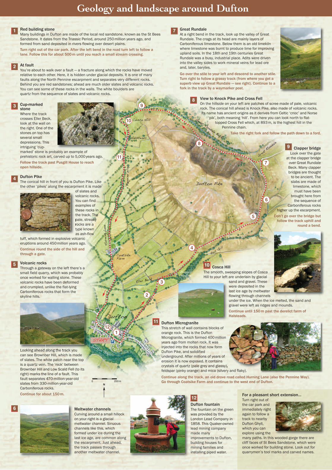
Red building stoneMany buildings in Dufton are made of the local red sandstone, known as the St BeesSandstone. It dates from the Triassic Period, around 250million years ago, andformed from sand deposited in rivers flowing over desert plains. Turn right out of the car park. After the left bend in the road turn left to follow alane. Follow this for about 500m until you reach a small stream crossing.
At faultYou’re about to walk over a fault — a fracture along which the rocks have movedrelative to each other. Here, it is hidden under glacial deposits. It is one of manyfaults along the North Pennine escarpment and separates very different rocks.Behind you are red sandstones; ahead are much older slates and volcanic rocks.You can see some of these rocks in the walls. The white boulders arequartz from the sequence of slates and volcanic rocks.
Cup-markedstoneWhere the trackcrosses Eller Beck,look at the wall onthe right. One of thestones on top hasseveral smalldepressions. Thisintriguing ‘cup-marked’ stone is probably an example ofprehistoric rock art, carved up to 5,000years ago.Follow the track past Pusgill House to reachopen hillside.
Dufton PikeThe conical hill in front of you is Dufton Pike. Likethe other ‘pikes’ along the escarpment it is made
of slates andvolcanic rocks.You can findexamples ofthese rocks inthe track. Thepale, streakyrocks are atype knownas ash-flow
tuff, which formed in explosive volcaniceruptions around 450million years ago.Continue round the side of the hill andthrough a gate.
Volcanic rocksThrough a gateway on the left there’s asmall field quarry, which was probablyonce worked for walling stone. Thesevolcanic rocks have been deformedand crumpled, unlike the flat-lyingCarboniferous rocks that form theskyline hills.
Looking ahead along the track youcan see Brownber Hill, which is madeof slates. The white patch near the topis a quartz vein. The ‘nick’ betweenBrownber Hill and Low Scald Fell (to itsright) marks the line of a fault. Thisfault separates 470-million-year-oldslates from 330-million-year-oldCarboniferous rocks. Continue for about 150m.
Clapper bridgeLook over the gate
at the clapper bridgeover Great RundaleBeck. Many clapperbridges are thoughtto be ancient. Theslabs are made oflimestone, whichmust have been
brought here fromthe sequence of
Carboniferous rockshigher up the escarpment.
Don’t go over the bridge butfollow the track uphill and
round a bend.
Great RundaleAt a right bend in the track, look up the valley of GreatRundale. The crags at its head are mainly layers ofCarboniferous limestone. Below them is an old limekilnwhere limestone was burnt to produce lime for improvingupland soils. In the 18th and 19th centuries GreatRundale was a busy, industrial place. Adits were driveninto the valley sides to work mineral veins for lead oreand, later, barytes.
Go over the stile to your left and descend to another stile.Turn right to follow a grassy track (from where you get asuperb view up Great Rundale — see right). Continue to afork in the track by a waymarker post.
Cosca HillThe smooth, sweeping slopes of CoscaHill to your left are underlain by glacial
sand and gravel. Thesewere deposited in thelast ice age by meltwaterflowing through channelsunder the ice. When the ice melted, the sand andgravel were left as ridges and mounds.Continue until 150m past the derelict farm ofHalsteads.
Dufton MicrograniteThis stretch of wall contains blocks oforange rock. This is the DuftonMicrogranite, which formed 400millionyears ago from molten rock. It wasinjected into the rocks that now formDufton Pike, and solidifiedunderground. After millions of years oferosion it is now exposed. It containscrystals of quartz (pale grey and glassy),feldspar (pinky orange) and mica (silvery and flaky).
Continue along the track, an old drove road called Hurning Lane (also the Pennine Way).Go through Coatsike Farm and continue to the west end of Dufton.
View to Knock Pike and Cross FellOn the hillside on your left are patches of scree made of pale, volcanicrock. The conical hill ahead is Knock Pike, also made of volcanic rocks.Its name has ancient origins as it derives from Celtic ‘cnoc’ and Norse
‘pik’, both meaning ‘hill’. From here you can look north to flat-topped Cross Fell which, at 893m, is the highest hill in the
Pennine chain. Take the right fork and follow the path down to a ford.
Dufton fountainThe fountain on the greenwas provided by theLondon Lead Company in1858. This Quaker-ownedlead mining companymade manyimprovements to Dufton,building houses formining families andinstalling piped water.
1 7
2
3
4
5
Meltwater channelsCurving around a small hillockon your right is a glacialmeltwater channel. Sinuouschannels like this, whichformed under ice during thelast ice age, are common alongthe escarpment. Just ahead,the track passes throughanother meltwater channel.
6
8
9
10
11
12 For a pleasant short extension…Turn right out ofthe car park andimmediately rightagain to follow atrack to nearbyDufton Ghyll,which you canexplore using themany paths. In this wooded gorge there arecliff faces of St Bees Sandstone, which wereonce worked for building stone. Look out forquarrymen’s tool marks and carved names.
Geology and landscape around Dufton