outside with the fosters
DESCRIPTION
Join us on our adventures outside!TRANSCRIPT
Outside With The Fosters
Fall, 2013
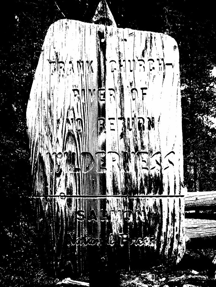
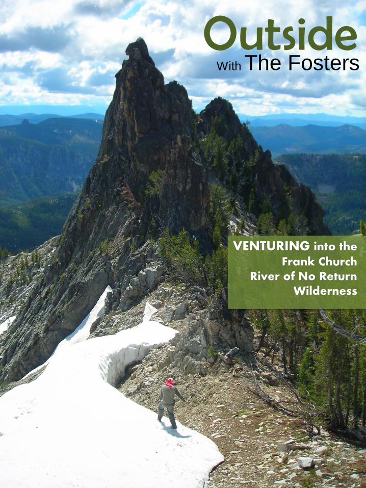
VENTURING into the Frank Church
River of No Return Wilderness
Facts about the Frank Church Wilderness Black Lake 2013: What an Adventure! A Fall Jaunt Along Camas Creek Trail Cutting in Wilderness Area The Bighorn Crags
In this issue of Outside With The Fosters
2
3
20
23
43
1

BEARGRASS
The stunning Stoddard Pack Bridge is located 20 miles from Shoup, ID. It was originally built in 1937 by the CCC (Civilian Conservation Corps). This sus-pended bridge is one of a handful bridges that span the main salmon river allowing the adventurous to enter the wild-erness by horse or on foot (Bridgemeister.com; forest history. org).
This tall, fra-grant plant grows in abun-dance on sunny slopes and ridges in
STEEP COUNTRY!
The Frank Church River of No Return Wilderness came into existence (as a Wilderness that is) in 1980 under the direction of President Ronald Reagan. Within the 2,366,757 acres that make up this wild country, visitors will be challenged by some of the steepest country in the United States! In fact, the Salmon River Canyon is deeper than the Grand Canyon! People have visited this land for thousands of years and Shoshone and Nez Pierce Indian artifacts have been found in abundance throughout the canyon (USDA FS).
many western states and Canada. Xerophyllum tenax (the scientific name) blooms in 5-7 year cycles and easily regrows after fire. The flowers are often eaten by elk and dear, and the slender leaves were used by Native Americans for basket weaving (plants.usda.gov).
2
Animal life in the wilderness is very diverse. Big game includes critters such as elk, deer, moose, mountain goat, and sheep. Large predators such as bear and
wolf lurk through the area in abundance while their smaller comrades, such as the bald eagle, soar the skies. And we cannot forget the fish! The salmon river is home to many varieties including the prehistoric sturgeon!
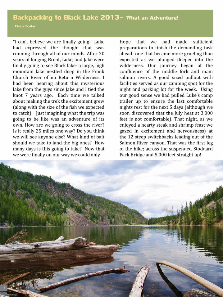
"I can't believe we are finally going!" Luke had expressed the thought that was running through all of our minds. After 20 years of longing Brent, Luke, and Jake were finally going to see Black lake- a large, high mountain lake nestled deep in the Frank Church River of no Return Wilderness. I had been hearing about this mysterious lake from the guys since Jake and I tied the knot 7 years ago. Each time we talked about making the trek the excitement grew (along with the size of the fish we expected to catch)! Just imagining what the trip was going to be like was an adventure of its own. How are we going to cross the river? Is it really 25 miles one way? Do you think we will see anyone else? What kind of bait should we take to land the big ones? How many days is this going to take? Now that we were finally on our way we could only
3
Hope that we had made sufficient preparations to finish the demanding task ahead- one that became more grueling than expected as we plunged deeper into the wilderness. Our journey began at the confluence of the middle fork and main salmon rivers. A good sized pullout with facilities served as our camping spot for the night and parking lot for the week. Using our good sense we had pulled Luke's camp trailer up to ensure the last comfortable nights rest for the next 5 days (although we soon discovered that the July heat at 3,000 feet is not comfortable). That night, as we enjoyed a hearty steak and shrimp feast we gazed in excitement and nervousness) at the 12 steep switchbacks leading out of the Salmon River canyon. That was the first leg of the hike; across the suspended Stoddard Pack Bridge and 5,000 feet straight up!
4
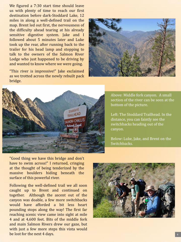
We figured a 7:30 start time should leave us with plenty of time to reach our first destination before dark-Stoddard Lake, 12 miles in along a well-defined trail on the map. Brent led out first, the nervousness of the difficulty ahead tearing at his already sensitive digestive system. Jake and I followed about 5 minutes later and Luke took up the rear, after running back to the trailer for his head lamp and stopping to talk to the owners of the Salmon River Lodge who just happened to be driving by and wanted to know where we were going.
“This river is impressive!" Jake exclaimed as we trotted across the newly rebuilt pack bridge. "Good thing we have this bridge and don't have to swim across!" I returned, cringing at the thought of being tenderized by the massive boulders hiding beneath the surface of this powerful river. Following the well-defined trail we all soon caught up to Brent and continued on together. Although the ascent out of the canyon was doable, a few more switchbacks would have afforded a bit less heart pounding stops along the way! The first far reaching scenic view came into sight at mile 4 and at 4,600 feet. Bits of the middle fork and main Salmon Rivers drew our gaze, but with just a few more steps this vista would be lost for the next 4 days.
Above: Middle fork canyon. A small section of the river can be seen at the bottom of the picture. Left: The Stoddard Trailhead. In the distance, you can faintly see the switchbacks heading out of the canyon. Below: Luke, Jake, and Brent on the Switchbacks.

Trekking on we came to our first water and food stop (both of which were much needed) at color creek which sits at 6,500 feet. Blessed tortillas! Although I originally thought Luke was crazy for bringing the entire 20 count, after eating two myself, along with the spicy, ready-made backpacker meal, I was grateful he was willing to carry the extra weight (and I still owe him for that...)! "Let's see... there should be a trail nearby that takes us to the top of Nolan Mountain. And from
"I don't know. That is what the directions are for the 'easiest' route" I returned.
However, I began to realize Brent's concern for taking that path- we were currently 5 hours into our hike and only at 6,500 feet. That means we still had to ascend around 3,000 feet to the top of the first peak another 500 feet from the saddle of the first to the top of the second and drop 1,200 feet down to the lake all in 7 miles. Oh, maybe that isn't the best route, and more importantly maybe we should have planned on not seeing Stoddard Lake the first night! Too late now! And so we were off again, following the well beaten Stoddard trail deeper into the Frank Church.
Lunch Stop #1 Bushwacking up Nolan Mtn.
5
there we just follow the ridge over twin peaks and drop basically 2 miles into Stoddard lake... 7 more miles is all!" I enthusiastically gave the directions from the Hiking Idaho book to my comrades.
"What is the elevation of those twin peaks?" Brent questioned. “Right around 9,000 feet". I responded quickly noticing the questioning look in his eyes.
“And why do we have to go over the top of them and not just go around?“

Brent was getting no better and the going had to be slow to keep the group together. However, even with everyone feeling great we couldn't have moved much faster due to the endless amount of fallen logs that continuously blocked our path. The day was quickly waning on as well as our energy so a camp site had to be found. Yet, one necessity kept us moving; water! On top of Nolan Mountain it was hard to see out past 10 yards. The healthy growth of firs all towered around 20 feet, indi-
cating that the last fire had rushed through this area 20-25 years or so ago. Our directions indicated an old hunting camp off to the south west of the summit and we made camp there. No Stoddard Lake tonight. Nine hours and 8 miles from the beginning of our day we happily found our first camp next to a bustling spring of mountain fresh water, with a great view of the Big Horn Crags. Elevation 7,902 feet. By morning Brent's condition had not improved and thus we were faced with a difficult choice- turn back or separate. We were only one day into the trip we
had planned for 20 years; how could we turn back now?! But, we couldn't just send Brent off on his own to wallow in his illness at base-camp while we continued on, could we?
6
First Camp!
7
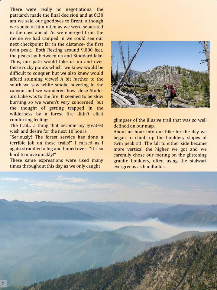
There were really no negotiations; the patriarch made the final decision and at 8:30 am we said our goodbyes to Brent, although we spoke of him often as we were separated in the days ahead. As we emerged from the ravine we had camped in we could see our next checkpoint far in the distance- the first twin peak. Both Resting around 9,000 feet, the peaks lay between us and Stoddard lake. Thus, our path would take us up and over these rocky points which we knew would be difficult to conquer, but we also knew would afford stunning views! A bit further to the south we saw white smoke hovering in the canyon and we wondered how close Stodd-ard Lake was to the fire. It seemed to be slow burning so we weren't very concerned, but the thought of getting trapped in the wilderness by a forest fire didn't elicit comforting feelings! The trail... a thing that became my greatest wish and desire for the next 10 hours. “Seriously! The forest service has done a terrible job on these trails!" I cursed as I again straddled a log and hoped over. "It's so hard to move quickly!“ These same expressions were used many times throughout this day as we only caught
glimpses of the illusive trail that was so well defined on our map. About an hour into our hike for the day we began to climb up the bouldery slopes of twin peak #1. The fall to either side became more vertical the higher we got and we carefully chose our footing on the glistening granite boulders, often using the stalwart evergreens as handholds.

8
"We are almost there!" Luke called back to Jake and I as we neared the top of the first peak. The excitement grew inside of me as we crested the top. The wind blasted me as I exited the shelter of the trees and...what! A false summit! Yes indeed. The "peak" we had been gaining on all day was situated bellow the final 500 foot prominence of the first peak. Because of the steepness of this country we never could see the full peak until now. "Are you kidding me?! Wow. I guess that is where we go." Jake stated as we half- heartily gazed as the pile of rocks that Luke had already started to climb. It was lunchtime when we reached the true summit that yielded a 360degree view of this great wilderness. There is something about summiting a mountain like this... It can be strenuous, stressful, and sometimes discouraging to get there. But, when you are standing tiptoe with the sky nothing blocking your view, it is all worth it! However, included in that view was the second twin peak. Our path was to descend this rocky knoll (knoll when compared to the next peak!) and head straight up the next one. I began to imagine Stoddard Lake... Was it really worth all this effort? Going up wasn't easy, but coming down was downright hard! Every step had to be precise due to the loosely piled rock that served
Above: Jake heading up Twin Peak #1 Below: Looking Southwest over the wilderness;. Stoddard Lake is behind the peak. Fire in the distance

9
as this mountain top. My quads were trembling as they strained to stop by body from rolling head first down the mountain. Jake and Luke were talking when I reached the saddle between the two peaks. Looking back up to the first peak and over to the second peak I was still awed at how steep they were! The guys turned to me and posed the plan they had been discussing-go around this peak, forget about Stoddard Lake, and bushwhack our way toward Black lake. At first I was a little surprised... what about Stoddard Lake? But my parched throat and growling belly quickly reminded me that a decent lunch hour had already past, we were out of water, and we had to get to black lake! The new route would take us along the steep foundation of twin peak #2 where we could see into the kitchen creek drainage and gain a better idea of where we needed to go. "Oh I hate side-hilling! But, I guess that probably is our best plan at this point. But we've got to get water and food SOON!" I replied to their proposal as I looked toward our new unmarked course, my spirits low at the thought of trekking the side-hill. "There are a few snow patches over there. We should easily be able to get water." Luke responded with his ever present optimism.
And so, we traversed over to Luke's patch of snow and found a few semi-precarious rocks to rest on. We gobbled down jerky, trail-mix, and Brent's candy that he "made" us keep, while our little pot slowly filled with mountain fresh water, and the mosquitos attempted to rid us of a few vials of blood. By the time we had boiled water for our backpacker meals and filled all of our bottles for the jaunt ahead, we had rested a good hour and felt greatly lifted. We quickly moved to the next hill top and gazed into a charred kitchen creek. It seemed the fire had moved through a few years ago and many blackened trees remained standing like tombstones covering the valley. From this location we could easily make out cottonwood butte, a straight shot as the foul flies. Sitting at 9,350 feet, this would be our next checkpoint before dropping into the drainage containing black lake. Unfor-tunately, we cannot fly and thus, the only problem for getting to the next point was the steep kitchen creek drainage lying at our feet. We slowly creeped down the canyon, fatigue quickly setting in due to the care that was needed with each step. I stumbl-

ed on some loose rocks, banged my camera against the ones still clinging to the hillside, and slid to a stop on my side. "I HATE steepness!" I yelled as I threw a rock toward the valley below as if somehow the hill's grade would be smoothed out by removing that one rock. Jake and Luke looked at each other and chuckled a bit,
10
bringing lightness to the situation, and silliness to my actions. "Here, use this." Luke said as he handed me one of his trekking poles. "I am good." I replied, determined to conquer this terrain on my own.
We continued our descent, found a small lake full of frogs, and quickly began to climb up the other side of the valley. We took a much needed break just below the ridge line around 5 pm. The day had been long and hard and had we been close to water, I would have voted to set up camp and rest. But, we pressed on and soon found ourselves gazing over the massive wilderness from the ridge line leading to cottonwood butte. We jumped a doe out of the brush and then saw it... the TRAIL! Ah, finally!
With that good news we breathed free as we soaked in the amazing view. And then I saw IT...
Lunch stop on a slope! Twin peak in the background.
Luke by Cottonwood Butte; the trail is behind him!

BLACK LAKE! "Hey! That's Black lake right!?" I called out. "Well I'll be! Look at that!" Jake replied. "We are so close! It's got to be only about 5 miles. We can totally make it tonight!" Luke put in. We quickly took off down the trail with newfound vigor! It is amazing how quickly my attitude changed after seeing both the lake and the trail. We scurried along at a click that not many could keep up with but after three hours, the stress from the day began to cloud our vision of the lake. We stopped at a fresh spring for a short break and although there was no flat ground in sight, we contemplated camping right there! But, we continued on and soon reached a saddle and the first official posted sign on this journey, barely hanging on to the scorched tree it was nailed to. “ Black Lake" "It really does exist!" I exclaimed as if the memory of the lake sighting wasn't enough to convince me that this illusive wonder was real.
11
Can you find the lake? Follow the canyon…
From the top of the saddle we could see to the east and had a great view of Basin Lake. "Maybe we should camp there tonight. It's close." I put in. Before we gave up for the night we all would be wishing that we would have taken this suggestion! "It can't be that far down to black lake; maybe two miles. We can make it tonight." Luke stated with enthusiasm. Our map indicated that there were two trail options; one dropping into the steep gorge to our west (and the way the arrow seemed to be pointing), and another straight ahead that switch backed down the canyon. We attempted to find the trail that would switchback us down, but had no luck. Either the scars from the last fire were hiding the path or our map was wrong. Plus, the sign directed us down the gorge, right? And so we began one of the steepest, longest, and most challenging descents I have ever experienced!

12
Every step had to be made with exactness and thus our pace was extremely slow. I was basically hiking from tree to tree, using the trunks to steady and pull myself along. Even with the support of the trees I often stumbled which led to the culmination of a frustrated attitude. "We have got to find a place to camp. We aren't going to make it tonight. We can't even see the bottom of the canyon yet!" I exclaimed my distressed thoughts.
Although Jake and Luke must have felt the same way, they said nothing. We pressed on as the encroaching night sky continued to hide the sun's light making the hiking more difficult with each step. Jake handed me the trekking pole that he had stolen from Luke a while earlier and although I wanted to decline I knew I needed it. Luke was a ways ahead of us as the days last light succumbed to the darkness.
"Over here guys!" We heard Luke call out and we made our way to him where we saw a heaven sent flatish piece if ground that quickly became our camping spot. It was about 9:30 by the time we finally had boiling water for our nights meal; nourishment that was very needed but that none of us really wanted to eat. Jake especially wasn't feeling good and I had to basically force food down his throat. Bed came soon after we washed our dishes. We didn't even take time to wash the days grime from our bodies, but instead carried it into our beds. Although we only had a 1/4 inch Thermarest between us and the rocky, uneven ground, it didn't take long for us to fall into a deep sleep. 11 miles, 13 hours, elevation approximately 7,800 feet.
The morning light woke us too early for our tired bodies, but the excitement of seeing the lake for sure today was like the anticipation of seeing Santa's work on Christmas morning! Plus, today was July 12, meaning Jake and I had been hitched for exactly 7 years! What a great place to be for our anniversary! I was out of Jake and I's tent first and had to laugh when I saw Luke's misshapen tent! He obviously didn't give too much effort into putting it up. "I have a rock pillow!" Luke cheered as he poked his head from the tent and lifted up the end to proudly show-off his resource-fulness! I was glad for his happy attitude.
After a meager breakfast we moved out, or should I say down the canyon. Two hours and about 2 miles later we reached the middle of the draw that Peak Creek flows through and into Black Lake. Although it was nice to not be side-hilling, this new terrain presented its own challenges. Most of the ground was saturated with water and we had to choose our steps with caution. Luckily, there was also a lot of deadfall providing natural bridges for us to use. After about a mile of moving slowly through this environment, we moved up-hill to get out of the swampy ground. And what a good decision it was because we found the thing we had coveted the most during this trip; the trail!
"Well, I guess we know what path to take to get out of here!" Jake said. Of course, following the trail allowed us to mobile quickly. We couldn't see the lake until we were standing at its edge, and oh what a sight! 3 miles, 4 hours, elevation 6,452 feet.

"Let's jump in!" I said after Jake reminded me of the filth covering my body and we soon made good on this refreshing recommendation! The rest of the day was spent enjoying this magnificent lake. What was it that made this place so special? A few unique things about this lake include how it was formed, its size, and its color. After walking around the lake we determined that it was formed by a landslide that occluded part of the drainage, damming the creek. Also, it is a large lake. Probably the second largest in the Frank Church next to Ship Island Lake, and it displays a black color- hence the name. Why the dark color? Don't know, but it is definitely black! And the best part of all... we were totally alone in the peaceful wilderness! Although we never caught the lunkers that the guy 20 years ago talked about, the 2 pound rainbows were a welcome addition to our lunch and dinner. Not many dishes can beat fresh mountain trout fried over an open campfire!
13
"We've toiled for many miles, many ranges and many rivers, many peaks and many valleys. And after long last we finally behold the gem of the Frank Church. The mythical, the mysterious, the unreachable, Black Lake." Jake gave his tribute to the lake as we approach to behold its beauty!
Not quite a Lunker!

We turned in early that night. It felt so good to lay down, my thin bedding providing ample cushion between me and the dirt. I memorialized our trek thus far by playing a little music from Lord of the Rings on my iPod making me feel like we were really in middle earth!
I realized just before I fell asleep that I had not had any trouble sleeping on this trip as I have on previous outings. Maybe it was the new Thermarest mat I had brought. Or, maybe it was the result of the extreme fatigue we had experienced thus far. "Yes, this has been the most difficult hike I have ever done!" I thought as I shut my eyes and drifted off.
14
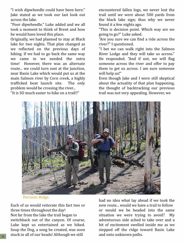
"I wish dipwheedle could have been here." Jake stated as we took our last look out across the lake. "Poor dipwheedle." Luke added and we all took a moment to think of Brent and how he would have loved this place. Originally, we had planned to stay at Black lake for two nights. That plan changed as we reflected on the previous days of hiking. If we had to go back the same way we came in we needed the extra time! However, there was an alternate route... we could turn east at the junction, near Basin Lake which would put us at the main Salmon river by Corn creek, a highly trafficked boat launch site. The only problem would be crossing the river... "It is SO much easier to hike on a trail!!“
Each of us would reiterate this fact two or three times throughout the day! Not far from the lake the trail began to switchback out of the canyon. Of course, Luke kept us entertained as we hiked. Soup the Dog, a song he created, was soon stuck in all of our heads! Although we still
15
encountered fallen logs, we never lost the trail until we were about 500 yards from the black lake sign; thus why we never found it a few nights ago. "This is decision point. Which way are we going to go?" Luke asked. "Are you sure we can find a ride across the river?" I questioned. "I bet we can walk right into the Salmon River Lodge and they will take us across." He responded. "And if not, we will flag someone across the river and offer to pay them to get us across. I am sure someone will help us!“ Even though Jake and I were still skeptical about the actuality of that plan happening, the thought of backtracking our previous trail was not very appealing. However, we had no idea what lay ahead if we took the new route... would we have a trail to follow or would we be headed into the same situation we were trying to avoid? My adventurous side ached to take over and a bit of excitement swelled inside me as we stepped off the ridge toward Basin Lake and onto unknown paths.
Decision Ridge.

In this part of the wilderness, the forest was much different- it was thick, tall, and old. Luckily, my prayers had come true as we were blessed with a well-beaten trail, making the going quick! The trail snaked along the mountains, dropping into multiple drainages and crossing many creeks. After a few hours, it dropped us at a small, old forest service cabin that appeared to be an outfitter camp (we later learned that this area was in fact used by the Salmon River Lodge as a hunting camp). It was the perfect setting for our lunch! Our appetites had returned in full force and we quickly downed a few backpacker meals, some Ramen, jerky, and other scraps that had been jostled in our packs for the last 3 days. With bellies full and spirits hi due to the amount of ground we had been able to cover already, we again headed out. But, where did the trail go?? "It has got to be right over here!" Luke exclaimed. "Let me see the map." My hi spirits quickly plummeted as I thought of once again having to bushwhack. "It looks like there is a trail on the ridge. Do you think we missed the trail that cut up there back a bit?" Jake asked as he and Luke poured over the map. "It couldn't have just disappeared. It has been so well beaten. Why would it stop at this camp?" Luke observed.
16
And so, we backtracked, looking for a trail that would take us up the mountain. Jake was leading and narrowly escaped the powerful talons of an angry pine chicken that was protecting her brood! We soon found a trail, but it was headed away from the mountain. "Maybe this drops off and heads toward the river." Luke said as he turned down and followed the trail. We quickly realized that this path was not taking us to where we needed to go so we backtracked on our backtrack, back to the cabin and led out the way we thought the trail should go, one more time bush- whacking through the Frank Church Wilderness. Luckily, this didn't last long as we soon found the beloved trail!
A bit deeper we came to the lovely creek crossing where we stopped for water. I set up the camera to take some shots of this beautiful creek while Jake and Luke filtered. We loaded our backs with our packs and began to cross the creek when Luke stopped, stooped by the water and said "That looks like gold!" Jake and I looked, and sure enough there were flecks of gold colored minerals all over in the creek. And so we spent the next 15 minutes picking out tiny flecks of what could possibly be gold. Was it really? I guess you will never know!

By 6:00 we reached the last summit of the trip; butts creek point. A well maintained fire lookout greeted us as we moved to peer once again into the Salmon River canyon. Standing at 7,800 feet we could see where the river had slowly carved one of the deepest canyons in the United States, but we could not actually see the river. "We are covering some ground!" Luke pointed out.
17
We had already been going for 9 hours and had covered around 15 miles, obvious proof that following a trail makes much faster hiking! "4-5 miles to go and it's all downhill from here. Do you think we can make it before dark?" I questioned. "Yeah!" Luke answered, and we were off! The realization of how fatigued we really were came about an hour later. The trail was very easy
to follow, but just like the switchbacks we climbed up to begin this journey, many of the ones on this side of the canyon were STEEP! The difference however, was that now we were headed down, which gave my heart a break, but my legs fatigued as quickly from putting on the breaks with each step! I let on that I needed a break and we all plopped down on the edge of the trail, legs nearly hanging off the side of the mountain. I was so tired.
Dramatic differences in the landscape
Butts Creek Fire Lookout

18
I thought about the path ahead; what if we couldn't make it tonight? My tired body was again dictating my thoughts! We would have to sleep in the middle of the trail because it is the only flat ground! And what about water? We are running low and good luck finding any on this unforgiving hill-side! Maybe we should have camped at the lookout. Brent didn't expect us until late tomorrow or the next day anyway! What if we went back there... No way! I am done climbing for this trip! The sugar from my snickers began to lift my blood glucose along with my thoughts. Although a nap would have given me the ultimate boost at this point, we had to keep moving. We soon broke out of the lush, thick growing firs and into the massive white pine territory. I often stopped and looked up in amazement at these incredible trees (the stopping was very important to not only take in the grander, but to avoid stepping off the mountain)!
I don't recall which of the 65 switchbacks it was that finally yielded us a view of the river... maybe 35, 40, or even 45, but it was a welcome sight! We knew if we could see it, we were getting close. Down, down, down we went until Luke called out the last turn "65!" My feet ached, I was out of energy, and felt very dirty! Following X creek, we made our way toward the river and the Salmon River Lodge. 11 hours, 19 miles.

19
I felt awkward as we entered the lodge's property. No one was in sight but there were many signs indicating that people were here. A couple of dogs greeted us at the steps of the lodge and a teenage boy quickly emerged to see what we wanted. We asked if there was any chance to get a ride across the river and he directed us to Mic, the seasoned jet boat driver. Mic assured us that he could take us across in the
amazing and we slept soundly. However, we did feel a bit guilty that Brent was back at the trailer with no idea what we were up to! The next morning we were fed a hearty omelet then treated with a jet boat ride down the river. What an amazing experience cruising down, and up, that river! Mic displayed his amazing ability to read the river, narrowly guiding us around motor busting boulders. By noon we were finally on the homeward side of the river of no return! Seven miles later, we surprised Brent as the guys from the lodge dropped us at the trailer. We couldn't wait to tell him our stories (which were much more eventful than his)! Heading down the road to home I reflected on the amazing experience we had just had. At times I was overcome with frustration, discouragement, and ultimate fatigue. But, each of those feelings was dissipated by the grandeur of the country and the wonder of our accomplishments! We had gotten our fix of Idaho Wilderness which, over the years, has become like an addictive drug that won't leave our systems! I can't wait until our next trip!
morning as it was almost dark (around 9:00) and allowed us to pitch our tents on the front lawn. We thanked him and headed toward our campsite. I couldn't wait to lie down! Before we made it to the lawn, a jet boat pulled into the dock and two guys jumped out. "You made it! I had a feeling that you all would end up coming out this way!" One of the guys called out to us in an excited voice. We soon learned that these were the same guys Luke ran into as we started our trek 4 days earlier. Brooks, the owner of the lodge, spotted the camera around my neck and said "Tell ya what, I will hook you all up with a hot shower and bed tonight in exchange for your pictures." We didn't hesitate to accept with a responding "Okay!" They then invited us into the lodge where we ate a homemade meal and chatted for 2 hours about our journey. It was interesting and fun to talk to everyone that night, but all I could think about was lying down!! My body ached for rest and I felt relieved when we finally shut the door to our room. Although we had to put our grimy clothes back on afterward, the shower felt

20
A Fall Hunt Along Camas Creek
In early November 2012, we (Jake, Elaine, Luke, and Brent) ventured out for a weekend of Elk hunting in the Frank Church. We made our base camp along Camas Creek near Meyers Cove, located 50 miles northwest of Challis.

21
The first day of hunting we spent roaming the hills south of Camas creek. There was tons of sign that many elk had spent time in this area, but to our misfortune it was not that day! However, we enjoyed each other’s company and the opportunity to be outside!
The next day, we decided to follow the trail down Camas Creek. This trail eventually ends at mile 11 when it runs into the Middle Fork of the Salmon River. At this point travelers can continue their trek down this river for about 30 miles or so before intersecting the main Salmon River. The beginning of this jaunt lead us through Meyers cove, an old mining establishment. A year prior to this Brent and Luke had seen and talked to elk in this area (literally
Luke called to the elk and had one cow walk within 20 feet of him). However, there were no elk this year.
The trail soon began to follow the path of the river, snaking its way down the canyon. It was easy hiking and the river was beautiful! Glimpses of colors hanging onto fall caught our eyes as we trekked along. High above us, on the tops of the canyon walls snow was beginning to accumulate indicating that winter was here. Besides the tumbling water, everything was still and peaceful.

22
We found a nice spot for lunch and built a campfire to keep us warm as our sweat dried. Everything tastes so much better when you are sitting by a campfire in the wilderness!
Still, no elk. The absence of that which we were hunting may have been due in part to another critter; wolves. The entire way along the trail we were mashing wolf tracks into the dirt, wondering how long it had been since they passed through. I half expected to see one of the furry beasts each time we rounded a corner. But, why would they be here if the elk weren't?
We finally made it to the Woodtick creek ford at mile 7, a place Brent had visited many years ago on another hunt. Crossing the river would put us on the Woodtick creek trail, which heads out of the canyon to Woodtick Lake, and eventually leads to Sleeping Deer Mountain. We turned around and headed back the way we came. Although it was the
same path, the scenery seemed different as we were now constantly looking upstream. At one point massive boulders were strewn about the canyon as if this was the place of a mighty battle between rock giants hundreds of years ago!
About 1/2 mile from where we parked the truck we saw our first animal of the day- a lonely mountain goat grazing on the hill-side. I was excited as this was a first for me! He quickly faded away as the last light of the day escaped over the mountains. We did eventually find the elk; they were hanging out in Challis the whole time, safely munching away on hay stubble! Jake and I both let out an “Are you kidding me!” when we first saw them. Although we did not get to take one home for our freezer, as we reminisced on the fun we had and rejuvenation gained from being outside we knew the trip had been worth it!

Trail Cutting in the Frank Church
-Jake Foster
The beauty of our surroundings really should have been captivating for us. Luke and I were
somewhere between Fern Camp and Butt’s Creek lookout in the middle of the largest tract
of wilderness in the lower 48, and we were literally at the end of our energy. The beauty of
our surroundings was lost to us for good reason. We were taking turns single-handedly
running the four foot cross-cut saw, straining our eyes into the darkness, ready to bolt the
second the 50 foot snag finally gave way, crashing across the trail. As Luke operated the
saw, I had time to reflect on my situation. How did we end up on this trail, dozens of miles
into the wilderness with a cross-cut saw, axe, and 50 pound packs strapped to our backs,
fighting with a widow-maker on this trail in the middle of the night? 23

If you’ve never experienced the Salmon
River on the back of an 800 horsepower
jet boat, you really are missing out. It is
incredibly exhilarating to know that there is
about 4 inches of water between your feet
and school bus sized chunks of the Idaho
Batholith. Our destination was around 14
miles downriver from the Salmon River
lodge, at a place called “disappointment
camp.” Our fifty pound packs lay in a heap
at the rear of the boat. We were fully
prepared to tackle 10 days and
somewhere around 100 miles of
wilderness trail. We glided down the river,
propelled by something like 800 horse
power generated by the twin 460 Ford
motors. Bald eagles soared overhead as
the spray of the river literally whetted our
appetite for the grand wilderness that lay
ahead of us. Bring it on!
I couldn’t help but snicker a bit the night
before when we looked at the map of our
route. Camps with names like “dismal,”
“hungry,” “disappointment,” and meadows
with names like “Cold,” and “Phantom,”
dotted the trail like some cartographer’s
idea of a silly joke.
“These sound like really encouraging
names, huh?” I had quipped when the
thought occurred to me that the names
didn’t exactly inspire reassurance to the
prospective wilderness trail clearing crew.
We would find out that the names of the
hunting camps and meadows were
undoubtedly inspired by the landscape.
After the relaxing jet boat ride down river,
we strapped on our packs, the axe and
cross-cut saw and began the first leg of the
journey. Our first destination would be the
Hungry Camp, some 8 or 9 miles from our
drop off point on the Salmon River. From
there we would continue on until we reached
Dismal Camp, which was another 10 miles
or so. After Dismal, we would make our way
to the high meadows in the headwaters of
Cottonwood Creek, where we would then
decide the remainder of our course. There
are hundreds of miles of trail in the Frank
Church and we were very excited to see the
wild country. We were in store for a
remarkable journey in which we would both
walk away with one unforgettable lesson:
Mother Nature is a powerful and hulking
Goliath compared to the puny hands of men.
24

The trail followed a drainage marked with an impressively full stream of water for this time of
year. The trail itself snaked through the drainage like an indecisive raccoon: “Should I be on
this side of the creek or the other…no this side…no the other side…wait, I liked that side
better…nope I changed my mind…” I swear we crossed that stream about 39 times.
Strapping a large pack onto your back introduces you into a special place of inevitability—a
place where you are certain to suffer the effects of a displaced center of gravity. And who
better to learn the lesson than the living breathing cartoon character that is my brother Luke?
He has an uncanny ability to turn a typical slip and fall (is there such a thing?) into an
apocalyptic, world shattering cataclysm.
I was focusing intently on my
own feet around the 32nd or 33rd
(ok…I might be exaggerating. A
little) crossing when a commotion
ahead of me brought my eyes up
in time to see Luke’s entire upper
body submerged with limbs
flailing desperately to find a
purchase sufficient to pull him out
of the water. He was finally
successful (amid my laughter)
and emerged with nose and chin
dripping with icy mountain water.
It turned out that this was only
the first of 3 good spills he would
take on this trip.
We were making remarkably
good time, and were very much
looking forward to the opportunity
to use our shiny new cross-cut
saw when the first rumblings of a
mountain afternoon thunderstorm
sent its raindrops on the trail
ahead. The day changed rapidly
from a bright and sunny one to
one that sent us seeking shelter
on a bare south facing slope.
We hunkered under our tarp and
watched in awe as the wind did
its work on the trees across the
canyon. It is an amazing sight to
See a full grown white pine snap-
ped like a pencil. I still am unsure if it was this storm or the one we would experience in
another day or two that caused the massive destruction on the trail that we would find in
another 8 days. Mother Nature doesn’t care about trail crews.
Luke crossing the creek
25

senator before he died in 1984. A “wilderness” is designated as such to preserve the natural
ecosystem, and to provide a primitive tract of land that can remain “untrammeled” by man.
The wilderness experience is meant to be primitive. No mechanized or motorized
contraption is allowed in a wilderness boundary, and this of course means chainsaws. I had
never had the opportunity to run a cross-cut saw before, but what this saw was capable of
doing was truly astounding. But let’s not give too much credit to the saw, shall we?
Luke and I have the ability to communicate with each other through the language of work.
Neither one of us knew what to expect from the cross-cut saw, but we figured it out really
quick. The back and forth motion of the saw takes on a nice, steady rhythm as great chunks
of sawdust spill from the deepening slice. Occasionally we would stop and readjust our cut,
or we would place a wedge to keep the blade from binding. We learned that a single cut was
never enough; it would take as many as 4 or 5 cuts in order to make manageable chun-ks of
wood from the fallen behemoths. It was always a thrill to finally make that last stroke and
then send great 500 pound chunks of wood rolling down the steep Salmon River drainage
terrain.
By the time we finished our first tree, we were exhausted, and Luke’s ureteral stent was
chewing him sore. We pushed ahead past several more down trees (including another
behemoth white pine) and found our camp beneath the canopy of a grove of gigantic, silent doug firs.
Our first opportunity to use the cross-cut came
after some wet feet, a rattlesnake, and several
miles. It was a massive douglas fir that was
undoubtedly a victim of the recent storm. It lay
parallel to the steep slope, and lay across the trail
at a slightly oblique angle. We unsheathed our
blade and went to work.
The Frank Church River of No Return Wilderness
was created in 1980, and was originally simply
“River of No Return Wilderness.” For silly
sentimental and political reasons, it was renamed
and given the name Frank Church after the
Every now and then, you’ll experience
something in your life that will really
stick with you. You’ll pile up the years
and pave a fuzzy road behind you, but
occasionally that road weaves its way
out of the mundane and into the
vibrant. This whole trip was a journey
in the vibrant, but there were a few
times that I seriously had to stop and
remember to breathe. One of these
times happened well into our second
day when we finally reached the top of
the canyon and found ourselves
greeted by an impressive grove of
majestic white pines.
Jake and the saw! 26

The western white pine is Idaho’s state tree. They are a
magnificent evergreen that can grow well over 200 feet tall and
live for just as many years. It must have been an absolutely
stunning sight to behold the old growth forests of centuries ago
where white pines covered millions of acres in the Northern
Rockies province of America. Sometime around 1910, the quick
demise of these great forests began with the accidental
introduction of a fungus called blister rust. Losses from rust were
only compounded by the spate of pine beetles, as well as from
loggers who prized the white pine for its enormously straight and
sparsely limbed trunk. Today, the old forests of white pines are
7% what they used to be only 40 years ago. But I will tell you:
there is a stand of white pines somewhere between hungry camp
and dismal mountain that will undoubtedly take your breath away.
27

They stood like great white sentinels
guarding the way to Cold Meadows and
the mother lode of a huckleberry patch
that lay a few miles down the trail. The
steep and unforgiving terrain had yielded
itself to beautiful green rolling undergrowth
with these towering monarchs standing tall
and proud overhead. We could see only a
couple of hundred yards before our view
would eventually be blocked out by the
thick, white bark of the distant trees. We
tramped across a carpet of enormous pine
cones that gave a welcome cushion
beneath to our tired feet. Wow it was a
cool sight! Our second night in the
wilderness was spent on a dry ridge top
with our sleeping bags unrolled under a
canopy of stars. We ate our second of
several batches of chili mac and spicy
Mexican rice and turned in for the night.
The trail descended into a valley at the toes of
Dismal Mountain, and we soon found ourselves
in the most expansive huckleberry patch I have
ever seen. We walked with laden backs and
outstretched hands under the canopy of firs and
popped mouthful after mouthful of the delicious
fruit. Huckleberries have been a part of my taste
palate for as long as I can remember. Eating
these fruits on the trail brought back memories of
going into the forest around Teton Valley with my
grandma and returning back to her farmhouse to
make fresh homemade huckleberry ice cream.
Luke and I quickly stained our finger tips and
tongues with the deep purple juices…and we
discovered later the reason why bears have
black poop!
28

The country that drains into the Salmon
River is a country of extremes. The climb
up from the river is extreme in steepness.
You will see the weather change from one
extreme to another in a matter of hours. As
you hike you will experience rain forest-like
undergrowth only to be replaced by
toothpick-like remains of trees only a few
miles down the trail. As you continue on
you will see the various stages of regrowth
in the forest as life slowly returns to burned
areas. You will have soggy feet for miles as
you trudge through bogs only to later face
dehydration for lack of any available water.
The extremes in the land will without a
doubt keep you on your toes.
We walked through several of these
extremes as we plodded past dismal
mountain towards Cold Meadows.
Gradually, our backdrop of old growth firs
began to thin as we entered another burn
area, and the skeleton-like rocky crags
became more and more visible through the
burned standing trees. We decided that a
high and long ridge to our left must be
Runaway Ridge—which was home to a trail
we planned on exploring later. Walking
through an old burn is a great opportunity
to learn about the behavior of fires. Fires
rarely carpet-bomb the countryside. Rather,
they move through in fits and starts, leaving
charred spots amid untouched patches as
they progress with the wind or the slopes.
What you will see as a result is the forest in
many stages of development as the various
successive species creep back into their
old turf. Seeing a burned forest is beautiful
in a very unique way.
We knew we were getting close to Cold
Meadows by guessing our location on our
not-so-detailed map. You would have
thought the sound of airplane motors
roaring down the canyon would have been
a dead giveaway. But as we ascended the
next hill, we were enveloped in a swath of 29

new growth lodge poles, and we couldn’t
see more than a couple of yards ahead.
So it was a great surprise when we finally
broke through the trees and beheld what
looked like a well beaten dirt road winding
through a vast meadow in the middle of
the Frank Church.
Aircraft have been flying into Idaho’s
remote landing strips like the one at Cold
Meadows for more than 60 years. When
the Central Idaho Wilderness Act was
passed, the 26 landing strips in the
wilderness were allowed to remain open
for business. As we entered the meadow
and set our feet onto the dusty runway,
we couldn’t help but feel that this road
just seemed out of place. Our thoughts
ran away with how exciting it would be to
fly into one of these landing strips as the
starting point for a wilderness adventure.
But those thoughts were quickly put
away when we realized that it had taken
us a day and a half of hiking to get to this
point! Flying into the wilderness was
most certainly and without a doubt
cheating! But it would be cool to
experience!
We made our way down
the runway to the far end
of the meadow and I
hoped the whole time that
a plane would come in to
give us a good landing
show. No planes came in,
but we did find a
convenient outhouse
stocked with toilet paper.
At the end of the runway
we found a series of
cabins and sheds, and
upon closer inspection, we
found that they were
occupied.
The ranger station’s
occupants were the
ranger and his small crew
of two trail hands. The
ranger (I can’t remember
the bloke’s name) was a
young dude from
somewhere back east. He
was sporting a long and
sparse beard and hair that
became increasingly more
disheveled as our visit
with him progressed. He
explained to us that he
and his crew’s job was to 30

maintain the ranger station and clear trails
in the wilderness. He took us on a tour of
the old buildings and showed us their
supply of tools and food. It would be quite
a job to live and work at this place for a
summer!
He managed a two person crew (besides
himself). One of his crew was out hiking
somewhere, but we got to meet his
second crew member…a gaunt young lady
with an impressive bird’s nest mess of
armpit hair and an exceptionally long and
pointy nose. It was fun to talk with them for
45 minutes or so, and we decided to take
our leave as a new storm began to roll in.
As we moved on, we decided that it takes
a certain breed to spend that kind of time
in the wilderness…or perhaps spending
that kind of time in the wilderness turns
you into a certain breed. In either case,
you surely will be able to find a couple of
fine specimens of hairy wilderness hippies
living in Cold Meadows.
Cold Meadows lies at the headwaters of
Cottonwood Creek, and the landscape
gradually transforms from a boggy flatland
into a picturesque valley as the trail follows
the creek. You will quickly leave the large
meadow and become boxed in once again
by steep and densely wooded mountain
slopes. We had a canopy of clouds
overhead as we traversed onward; and the
air was slightly claustrophobic compared to
the wide open air of the meadow.
But the landscape was about to
change once again.
We knew when we had found
Middle Meadow as anyone would
know these meadows when you
first happen upon them. Middle
Meadow is not as large and
expansive as Cold Meadows, but
it is in no way less beautiful.
Cottonwood Creek flows through
the middle of meadow, and the
meadow floor is covered with a
thick mat of grass and sedges.
Going from steep strenuous slopes to vast
expansive meadows in a matter of hours is
really a great shock to the aspiring hiker.
In camp at Middle Meadow we decided our
next plan of attack: we would stay one night
at these meadows, then move on and
establish a base camp a Lower Meadow
where we would be able to branch out on
day trail clearing trips to Phantom Meadow
and Runaway Ridge. When we cleared
those sections of trail, we would pack up
and start toward Black Lake, Decision
Ridge and beyond. It was a good plan.
Middle Meadow
Ranger Station
31
We spent some time sitting at the edge of
the meadow in the twilight after we had set
up our camp. We reminisced about the
many trips we had taken with dad as we
looked out across the blanket of green
grass. We giggled when we remembered
the hairy folks we had met hours earlier.
And we marveled that we were back in the
wilderness only a couple of weeks after our
last excursion that had taken us only a
couple of mountain ridges away. Life was
good.
After a freezing yet refreshing cold
backpacker’s shower, we unrolled our
sleeping bags under the stars and turned
in for the night. In the morning Luke
described the wolf howls he had heard
during the night, but I had failed to hear
through my impenetrable wall of sleep.
That is a very eerie sound.
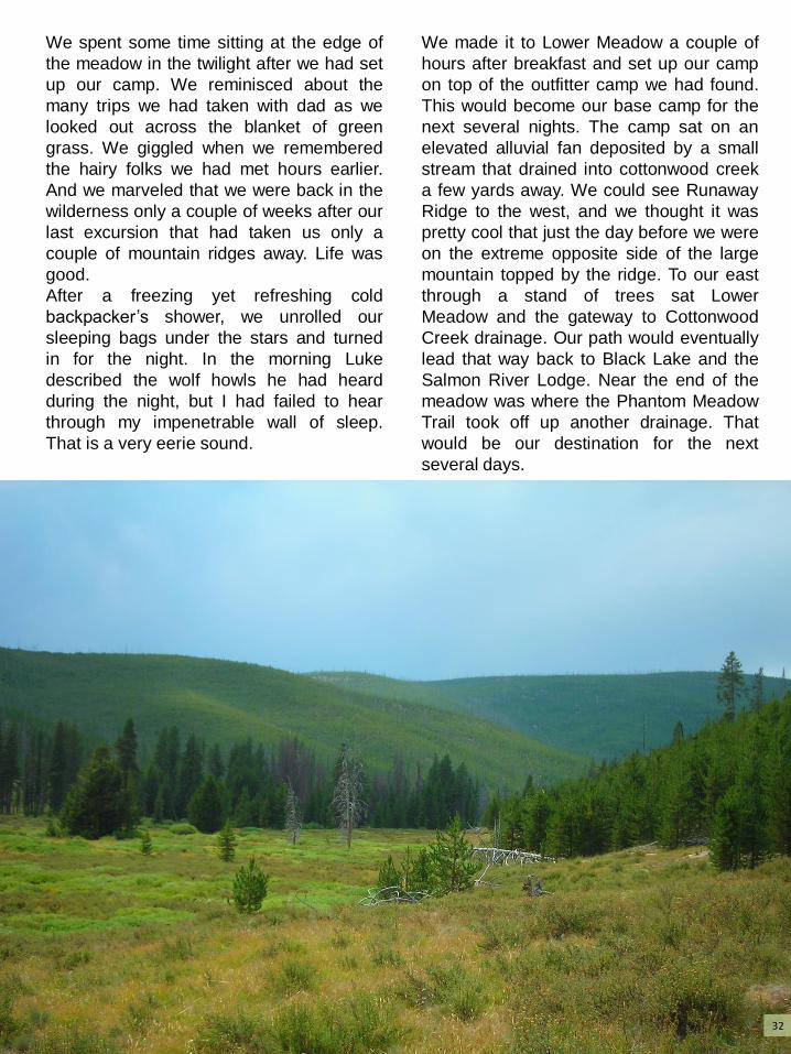
We made it to Lower Meadow a couple of
hours after breakfast and set up our camp
on top of the outfitter camp we had found.
This would become our base camp for the
next several nights. The camp sat on an
elevated alluvial fan deposited by a small
stream that drained into cottonwood creek
a few yards away. We could see Runaway
Ridge to the west, and we thought it was
pretty cool that just the day before we were
on the extreme opposite side of the large
mountain topped by the ridge. To our east
through a stand of trees sat Lower
Meadow and the gateway to Cottonwood
Creek drainage. Our path would eventually
lead that way back to Black Lake and the
Salmon River Lodge. Near the end of the
meadow was where the Phantom Meadow
Trail took off up another drainage. That
would be our destination for the next
several days.
32
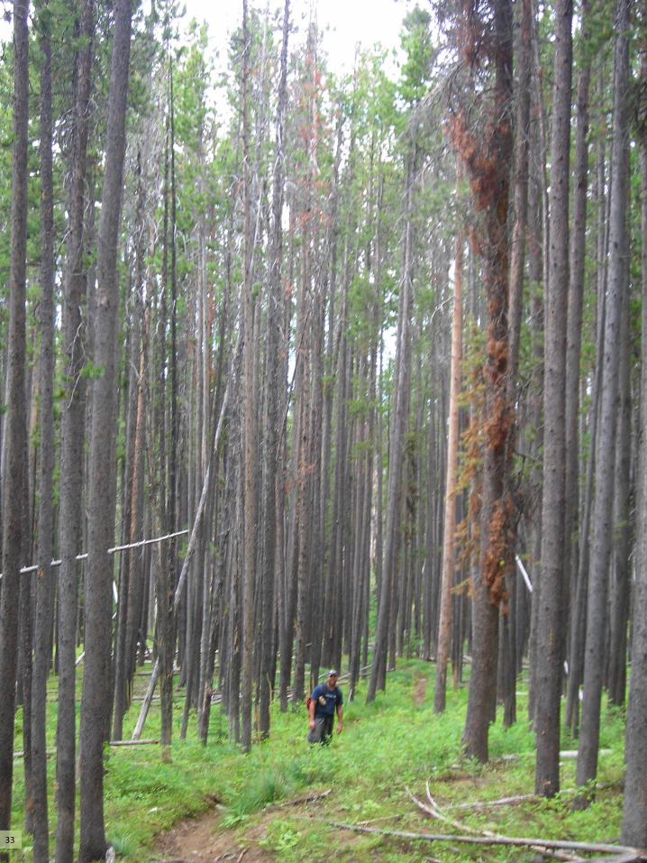
33

Spending several days
running a cross-cut saw
is tiring work. The trail
followed a pretty little
drainage surrounded by
thick lodge pole and
douglas fir forest. Fire
hadn’t reached a lot of
this area yet, but it
needed to as much of
the forest had been killed
off by beetles or other
disease. We would push
our way down the trail as
far as a day would allow
us, cutting and sawing
as we went. The morning
dew would be thick and any case, we finally made it to Phantom
Meadow.
Our next leg of the journey would take us
across Runaway Ridge. The trail to the
ridge took us across a high and steep
hillside where we were afforded a long
unimpeded view to the expansive
westward wilderness. Range after range
of jagged mountains snaked their way
across our view, and we knew that
somewhere between one of those ranges
the great Salmon River meandered its
way westward toward Riggins. We
counted 2 or 3 pillars of
smoke in the distance
that told of new fires
sparked by the previous
days’ thunderstorms.
Our path took us through
another endless patch of
huckle-erries and even a
patch of wild raspberries,
and at several points
along the trail we jumped
fat pine chickens…or
rather they made us
jump.
wet, and we would always start our days off with
sodden feet. Our starting point for the day
would get increasingly farther and farther from
camp as we made our progress up the
mountain. The weather would keep us on our
toes, and there was more than once when we
had to find shelter away from the dead trees as
the wind picked up. It is an unnerving
experience to hear the wind knock over the
trees with loud crashes all around you. We even
returned one evening to find a new tree blown
over in our camp! In
34

As the trail progressed through tall stands
of old growth lodge pole pine, we imagined
chasing wolves one day across the ridge.
It would be hard to find those pesky
critters we conceded as we could barely
see past more than 50 yards through the
trees. Eventually we came to a burn line
where a fire had passed perhaps 10 to 20
years before. This particular burn line was
pretty fantastic. We would later realize that
this line stretched as far as black lake in
an almost perfect demarcation between
old growth and new growth. It was a very
obvious and stark end of a fire season
from several years ago.
At the end of our Runaway Ridge hike we
decided to cut a path straight off the
mountain to our campsite rather than
follow the trail back the way we came. We
discovered that the going wasn’t
necessarily easy as we picked our way
through the thick new growth and log-
jumped across the dead and burned old
growth. It was a steep go, and it lead to
another epic fall by Luke, the cartoon
incarnate.
We had almost made it back to camp and
were once again following the course of
Cottonwood creek. It was cool because we
were clearly in a flood plain that testified of
serious spring runoff flooding from previous
years. We still continued to log-jump our
way along our route, and our path
eventually lead through a meadow of tall
grass. As I followed one log, I came to the
end of one log and the start of another with
a gap in between. I eyed my next step some
4-5 feet away and noticed a piece of rotten
wood right at the end of the log. I made a
quick mental note to extend my jump by
another foot or so to avoid the rotten
wood…and the thought occurred to me that
maybe I should warn Luke of the precarious
step. But, being the care-free little brother
that I am, and also being confident that
Luke was a big boy and would surely see
the same hazard I did, I continued on
without another thought on the matter. Sure 35

enough, not a second later, Luke made the step and his foot found the rotten wood. I didn’t
see the fall because I was focusing on my own footing. But I did hear the distinct sound of
rotten wood giving way with a crunch, a gasp of surprise from Luke followed by a grunt of
escaping air as he lit upon the ground. I turned around to see a sight that only Luke could
create for himself. He was completely upside down with his feet in the air. I thought for sure
he must have landed on his head. His gun had slipped out of its holster and was in the
grass and he struggled to get out of his awkward position. The whole time he cackled like it
was the funniest thing that could happen to him, and I of course joined in the laughter. Only
Luke can make a walk in a serene meadow both a catastrophe and a comic show all at the
same time.
36

We eventually packed up camp and started making our way
toward Black Lake and beyond. Our path again followed
Cottonwood Creek until the trail left the drainage and began a
steep climb toward the ridge separating us from Black Lake.
By this time in our trek we were well accustomed to long and
steep hikes, so we took each step in stride, only needing to
pause occasionally to clear a fallen tree. Eventually the trail
crested the hill and we saw below our familiar friend that we
had only met a couple of weeks prior. From our vantage point
several hundred feet up, it was already obvious that the lake
had dropped considerably since we had seen it earlier in the
month. The dry summer had drained it faster than the
mountain runoff could replenish its depths. We were happy to
find the trail accompanied by more huckleberries and we
again paused several times to fill our mouths.
37

Our plan was to spend lunch at the lake,
then continue on until we reached basin
lake. We would then spend some time on
the trails that crested the ridge above the
lake and between the lake and fern camp.
We had enough food for 2 days, and we
planned on spending those days in the
wilderness. We knew we had a very
strenuous climb ahead, though. The grunt
out of Black Lake to Decision Ridge was a
very steep and hard climb…but we were
officially on trail that we had seen before!
Now we were just back tracking! We also
knew that the trail was in very good
condition, with the exception of a stretch
on the hill above that would need to be
cleared. Heck, we had seen it all a couple
of weeks before and it was great! How
much could the trail have changed
between then and now anyway? We were
confident it would be a leisurely stroll back
to the lodge. Right.
We enjoyed a lunch of freshly caught
trout, and it was a welcome taste. We
reminisced for a few minutes on the shore
of the lake before we packed up and
began the last leg of our trek. The climb
out of the canyon was just as hard as it
was weeks prior. We had to stop at a
couple of spots to clear a rats nest of
down trees, but it wasn’t too bad. We had
gotten pretty good at running our
wilderness trail clearing equipment. It
gave us a chance to look back across the
expanse of country we had already
covered so far. We could follow the burn
line all the way from Black Lake to
Runaway Ridge.
When we got to Decision Ridge, we
decided to make one last quick call on the
satellite phone to Elaine and Jeni before
we dropped into the canyon and out of 38

created a lot of work for us up to this point on our
trek, and it undoubtedly would have also created
work ahead of us as well. Pesky summer storms.
Pesky short term memories.
Our surroundings began to close in around us as
nighttime fell. We made one last stop for dinner
and a quick rest, and then strapped on our lights
and continued onward. We began to slowly
realize that this wasn’t the exact same easy
going trail as it was the last time we were on it.
First of all it was dark. But more importantly, and
to our increasing dismay, the trail was bisected
again and again by fallen trees. The worst part
about it was that we couldn’t see the fallen trees
until we were right on them because of the
mountain darkness. We would both sound out a
resounding “Do-Oh!” every time we came upon a
new tree.
One very memorable sight came after we had
passed Fern camp. We were basically at the top
of the main Salmon River Canyon, and we could
see miles and miles to the north the
unmistakable glow of a forest fire. It was on the
other side of the river, and as we watched it burn
we could see licks of flame flicker across the
distant ridgeline.
We pushed through the darkness, and it seemed
like as soon as we had cleared one large tree,
we would round a corner only to find another
waiting for us. By the time we reached Butt’s
Creek Point, we were spent.
It is a unique feeling to be at a point where you
feel like you have absolutely no energy left to
burn. We had been on the trail for more than 16
hours. Our hike had begun at Lower Meadow
and we have traversed in and out of 5 drainages
carrying our 50 pound packs stopping only to run
the cross-cut or swing an axe. I have never been
so exhausted in my life. The old fire lookout was
a welcome sight when we finally reached it and I
didn’t even want to take time to eat anything. I
just wanted to drop my pack and crash for what
remained of the night.
Cutting in the dark
39
service. That is quite a cool thing to
do—make a phone call in the
wilderness. We finished our calls and I
was about to turn
off the phone when I noticed we had
just received a message from the
lodge…and suddenly our leisurely plans
had changed. We needed to be back as
soon as possible for VIPs who were
going to be visiting the lodge the next
day. At this point in the trek, we were
about 20 miles from the lodge, and it
was nearing 5 pm. We knew we could
make the distance in one day because
we had done it before. But we had
about 17 hours to be back, and there
was this silly little thing called night time
between us and our destination. But we
had headlamps and gumption, so we
said “what the heck” and tightened our
packs and started down the trail. We
would be there in no time. But we had
forgotten one thing: there had been an
event that had happened at the start of
our journey that surely had
We felt great relief. The worst was behind
us. We had only a five mile descent to the
canyon bottom in the morning. It was going
to be easy. Boy were we in for a surprise.
I want to tell you about Luke’s third fall. I
want to tell you how it is easy to laugh about
this one now that we are months removed
from it. But at the time it wasn’t a laughing
matter, because this one was more
serious—and he’s lucky it wasn’t worse. But
I suppose I better give you a bit of context
first.
When I was a kid on pack trips with dad, I
would imagine a giant robots stumbling and
thrashing through the forest, uprooting trees
and snapping them like popsicle sticks. It
would have a mouth full of jagged metallic
teeth, and it would breathe fire. I don’t know
why the thought of a lumbering mechanical
giant like that would get my little boy mind
reeling with excitement, it just did. Just
imagine how much destruction it could
cause! Well, Luke and I discovered that
some giant powerful robot has nothing on
good old Mother Nature.
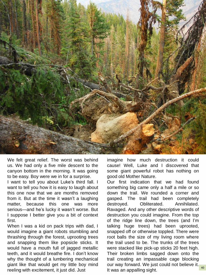
Our first indication that we had found
something big came only a half a mile or so
down the trail. We rounded a corner and
gasped. The trail had been completely
destroyed. Obliterated. Annihilated.
Ravaged. And any other descriptive words of
destruction you could imagine. From the top
of the ridge line down, the trees (and I’m
talking huge trees) had been uprooted,
snapped off or otherwise toppled. There were
root balls the size of my living room where
the trail used to be. The trunks of the trees
were stacked like pick-up sticks 20 feet high.
Their broken limbs sagged down onto the
trail creating an impassable cage blocking
our way forward. We just could not believe it.
It was an appalling sight. 40
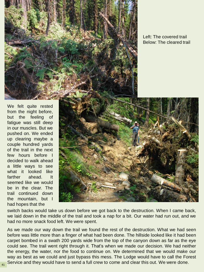
We felt quite rested
from the night before,
but the feeling of
fatigue was still deep
in our muscles. But we
pushed on. We ended
up clearing maybe a
couple hundred yards
of the trail in the next
few hours before I
decided to walk ahead
a little ways to see
what it looked like
farther ahead. It
seemed like we would
be in the clear. The
trail continued down
the mountain, but I
had hopes that the
switch backs would take us down before we got back to the destruction. When I came back,
we laid down in the middle of the trail and took a nap for a bit. Our water had run out, and we
had no more snack food left. We were spent.
As we made our way down the trail we found the rest of the destruction. What we had seen
before was little more than a finger of what had been done. The hillside looked like it had been
carpet bombed in a swath 200 yards wide from the top of the canyon down as far as the eye
could see. The trail went right through it. That’s when we made our decision. We had neither
the energy, the water, nor the food to continue on. We determined that we would make our
way as best as we could and just bypass this mess. The Lodge would have to call the Forest
Service and they would have to send a full crew to come and clear this out. We were done.
Left: The covered trail
Below: The cleared trail
41

We had quit putting the cross-cut back into
its case days before, because it was just
too big of a pain to take it out every time we
needed it. Why we didn’t put the stupid
thing back in its case then I will never
know. We were just so fatigued we couldn’t
think straight. We just continued on with
Luke carrying the razor sharp blade in front
of him like a trophy. We made our way up
the first pile of trees. It was near impossible
to get over as we struggled with our
backpacks and gear. I had made it over the
first stack of tangled trees when I
happened to look back. Luke had lost his
balance and was rolling off of a large fir
trunk. His pack had pulled him off balance
and as he fell, the cross-cut ended up
between his legs, grating his thighs and
shins with every turn. He finally ended 30
or so feet down the hill, again on top of his
head. His pack had pulled its way over his
head and he lay groaning with the saw still
between his shins. I threw my pack off and
struggled down to help him haul himself
back up to what was left of the trail. Then
we assessed the damage.
Songs and smells can bring back memories
better than photographs sometimes. To me,
there isn’t anything quite like a song that
can bring back long forgotten emotions and
feeling associated with memory. But I will
In all we covered something like 100 miles
or so of trail. It was an amazing experience
and is among the most difficult things I have
ever done. I would do it all again though, no
doubt about it. When wilderness gets in your
blood, you’re unlikely to ever fully recover.
always be able to look at the scars on Luke’s
legs if I need a jog in my memory to take me
back to those Salmon River Mountains. He
most certainly needed stitches, but that was
pretty much out of the question. We got the
bleeding stopped and patched him up the
best we could and then we put that cross-cut
saw away for good.
“Let’s get off this mountain,” Luke breathed
as he tested out his nifty new bandages. I
couldn’t have agreed more at that point. And
get off we did.
* * *
42

Bighorn Crags http://www.summitpost.org/bighorn-crags/316106
BIGHORN
43

CRAGS
44

Getting There: Take the Morgan creek road north of Challis, turn onto the panther creek road then turn on the Yellowjacket lake road and finally make the last turn into the crags campground.
Above: Ship Island Lake in the distance.
Right: Walking on top of a crag!
45

Terrace lakes
The trail near
Fish Fin Ridge
Fish Fin Ridge
For more information on hiking in the crags, visit: http://www.summitpost.org/bighorn-crags/316106
46

47
There are a multitude of places to go!

48