outline of quino recovery plan
TRANSCRIPT

QUINO CHECKERSPOT BUTTERFLY
(Euphydryas editha quino)
DRAFT RECOVERY PLAN
(January 2001)
Region 1U.S. Fish and Wildlife Service
Portland, Oregon
Approved: XXXXXXXXXXXXXXXXXXXXXXXXXXXXXXXXManager, California Nevada Operations Office,
Region 1, U.S. Fish and Wildlife Service
Date: XXXXXXXXXXXXXXXXXXXXXXXXXXXXXXXX

i
PRIMARY AUTHORS
This recovery plan was prepared by:
Alison AndersonCarlsbad Fish and Wildlife OfficeU.S. Fish and Wildlife Service
The primary scientific authors of this recovery plan were the Quino CheckerspotButterfly Recovery Team:
Dr. Edith Allen, Team ChairMark DoderoDr. Travis LongcoreDr. Dennis Murphy
Dr. Camille ParmesanDr. Gordon PrattDr. Michael Singer

ii
DISCLAIMER
Recovery plans delineate actions required to recover and protect federally listedplant and animal species. We (the U.S. Fish and Wildlife Service) publishrecovery plans, sometimes preparing them with the assistance of recovery teams,contractors, State agencies, and other affected and interested parties. Recoveryteams serve as independent advisors to the Fish and Wildlife Service. Draft plansare published for public review and submitted to scientific peer review before weadopt them. Objectives of the recovery plan will be attained and any necessaryfunds made available subject to budgetary and other constraints affecting theparties involved, as well as the need to address other priorities. Recovery plansdo not obligate other parties to undertake specific tasks and do not necessarilyrepresent the view, official position, or approval of any individuals or agenciesinvolved in the plan formation other than our own. They represent our officialposition only after they have been signed by the Director, Regional Director, orCalifornia/Nevada Operations Manager as approved. Approved recovery plansare subject to modification as directed by new findings, changes in species status,and the completion of recovery tasks.
Literature citation should read as follows:
U.S. Fish and Wildlife Service. 2000. Draft Recovery Plan for the QuinoCheckerspot Butterfly (Euphydryas editha quino). Portland, Oregon. x + 123 pp.

iii
ACKNOWLEDGMENTS
We greatly appreciate the numerous individuals who, over the course of years,contributed to the conservation of the Quino checkerspot butterfly and thedevelopment of this recovery plan including members of the Recovery Team,Greg Ballmer, Ken Osborne, and David Faulkner. This draft recovery plan wasprepared by Alison Anderson of the Carlsbad Fish and Wildlife Office with theassistance of Brenda McMillan and Nancy Kehoe. Tony McKinney, StaceyLove, Ed Turner, and Emilie Luciani assisted and advised on the use of theGeographic Information System (GIS) capabilities and development of RecoveryUnit maps. Other Fish and Wildlife Service staff, including Eric Hein,Christopher Nagano, Mark Elvin, Doug Krofta, Ken Berg, Andy Yuen, NancyGilbert, Jim Bartel, Michelle Shaughnessy, Susan Wynn, and Karin Cleary-Rose,have also contributed to the species’ conservation and recovery.

iv
EXECUTIVE SUMMARY
Current Status: The Quino checkerspot butterfly (Euphydryas editha quino,Quino checkerspot) is federally listed as endangered. This taxon occurs in SanDiego and Riverside Counties and several localities in Baja California Norte,Mexico. Although some habitat is under public ownership, no known Quinocheckerspot habitat complexes are entirely protected, and the species continuesto decline throughout its range.
Habitat Requirements and Limiting Factors: The Quino checkerspot is found inassociation with topographically diverse landscapes that contain low to moderatelevels of nonnative vegetation. Vegetation types that support the Quinocheckerspot are coastal sage scrub, open chaparral, juniper woodland, forblands,and native grassland. Soil and climatic conditions, as well as ecological andphysical factors, affect the suitability of habitat within the species’ range. Urbanand agricultural development, invasion of nonnative species, habitatfragmentation and degradation, increased fire frequency, and other human-caused disturbances have resulted in substantial losses of habitat throughout thespecies’ historic range. Conservation needs include protection and managementof suitable and restorable habitat; habitat restoration and enhancement; andestablishment of Quino checkerspot captive breeding program. This planidentifies six Recovery Units. Recovery Units are geographically bounded areascontaining extant Quino checkerspot populations that are the focus of recoveryactions or tasks. Recovery Units contain both lands that are considered essentialto the long-term conservation of the Quino checkerspot (e.g., networks ofsuitable habitat patches and connecting lands) and lands that are not consideredessential (i.e. lands not used by the butterfly such as urban development).
Recovery Priority: 6C, per criteria published in the Federal Register (48 FR43098; September 21, 1983). The priority is based on its being a subspecies(rather than a full species) with a high degree of threat, a moderate to lowpotential for recovery, and existing conflict between the species’ conservationand development.
Objectives: The overall objective of this recovery plan is to reclassify the Quinocheckerspot to threatened and ensure the species’ long-term conservation.

v
Interim goals include (1) protecting habitat supporting known current populationdistributions (habitat complexes), (2) stabilizing populations within knownpopulation distributions (described habitat complexes), and (3) conductingresearch necessary to refine recovery criteria. Reclassification is appropriatewhen a taxon is no longer in danger throughout a significant portion of its range. Because data upon which to base decisions about reclassification are incomplete,downlisting criteria in this plan are necessarily preliminary. There areinsufficient data on which to base delisting criteria at this time.
Recovery Criteria:1) Permanently protect habitat patches supporting known extant populationdistributions (habitat complexes) and possible landscape connectivity areasamong them. Adequate habitat reserve area sizes are estimated to be between1,200-4,000 hectares (3,000-10,000 acres) total per habitat complex. RecoveryUnits and habitat complexes described in this recovery plan are: NorthwestRiverside Recovery Unit, containing the Gavilan Hills habitat complex;Southwest Riverside Recovery Unit, containing the Warm Springs Creek andSkinner/Johnson habitat complexes; South Riverside Recovery Unit, containingthe Oak Mountain/Vail Lake, Sage Road/Billygoat Mountain, and BrownCanyon habitat complexes; South Riverside/North San Diego Recovery Unit,containing the Silverado and Dameron Valley/Oak Grove habitat complexes;Southwest San Diego Recovery Unit, containing the San Diego NationalWildlife Refuge, Otay Lakes, Otay Foothills, Otay Mesa, Marron Valley, andTecate habitat complexes; and Southeast San Diego Recovery Unit, containingthe Jacumba Peak habitat complex.
2) Permanently provide for and implement management of described habitatcomplexes to restore habitat quality, including maintenance of hostplantpopulations, maintenance of diverse nectar sources and pollinators, control ofnonnative plant invasion, and maintenance of internal landscape connectivity. The number of known occupied habitat patches and the density of butterflieswithin each Recovery Unit should be increased if declines are documented for 2consecutive years of average to high annual precipitation (based on the past 20years of local data). Management must be adaptive: i.e., ongoing surveys andmonitoring must be conducted to refine management strategies and delimit

vi
temporal and geographic patterns of Quino checkerspot exchange amongsuitable habitat patches.
3) Establish and maintain a captive propagation program for purposes of re-introduction and augmentation of wild populations, maintenance of refugiapopulations, and research.
4) Initiate and implement a cooperative educational outreach program targetingareas where Quino checkerspot populations are most threatened.
5) Two additional populations or metapopulations must be documented orintroduced in the remaining undeveloped coastal areas of the Quinocheckerspot’s historic range. Undeveloped coastal areas include the western andnorthern slopes of the Santa Ana Mountains (northern slope, see proposed NorthOrange Recovery Unit description in Recovery Strategy section below), thenorthwest corner of San Diego County (see proposed Northwest San DiegoRecovery Unit below), and undeveloped mesas and hills within the cities of SanDiego, Poway, and Santee, and adjacent unincorporated land within San DiegoCounty (see proposed South-central San Diego Recovery Unit below). Well-managed coastal preserves in San Diego or Orange County may be able tosupport stable populations of the Quino checkerspot butterfly. One of the twoadditional populations must include habitat within 10 kilometers (6 miles) of theocean to maximize the stable marine climate influence and minimizesusceptibility to drought. If new coastal populations are not documented by2004, experimental populations should be established and maintained untildownlisting criteria are refined. Additional inland (east of coastal areasdescribed above) habitat complexes documented outside of Recovery Units willnot be counted as one of the two additional populations specified here, butshould be considered important to recovery and addressed when delisting criteriaare developed.
6) The managed, protected population or metapopulation segments withincurrently described habitat complexes must demonstrate stability (constancy orresilience) without augmentation. When metapopulation distributions aredetermined by future research (one or more habitat complexes may belong to asingle metapopulation) or defined by reserve boundaries, the unit monitored for

vii
stability becomes the metapopulation. Stable Quino checkerspot populations aredefined by this recovery plan as those in which decreases in the number ofoccupied habitat patches are followed by increases of equal or greater magnitudewithin the 15 year period. The percent of patches that are occupied should beestimated by surveys for pre-diapause larval clusters (to demonstraterecruitment) in a sample of no less than 50 percent of the total number of patchesidentified within a population or metapopulation distribution. The surveyedsample of habitat patches must be distributed as equally as possible across themetapopulation distribution to avoid potential error caused by correlation ofsuitability among nearby patches.
7) Conduct research including: determining the distribution of extantmetapopulations; conducting preliminary modeling of metapopulation dynamics;investigating the function of hilltops as a resource for Quino checkerspotpopulations; investigating the contribution of multiple-year diapause tometapopulation stability; monitoring populations for further evidence of climate-driven range shifts; determining the effects of elevated atmospheric carbondioxide and nitrogen fertilization on the Quino checkerspot and its hostplant;determining the magnitude of threats from over-collection and non-native naturalenemies.
Actions needed:1) Protect habitat within the distribution of described habitat complexes.2) Restore habitat patches and enhance landscape connectivity within the
distribution of the habitat complexes3) Erect barriers to prevent dispersal from habitat patches into adjacent
high-traffic surface roads.4) Reduce off-road vehicle activity within the distribution of habitat
complexes and identified metapopulations5) Continue yearly reviews, monitoring and augmentation until stable
metapopulations have been maintained for 15 years withoutaugmentation.
6) Establish and maintain a captive propagation program.7) Initiate and implement an educational outreach program.8) Conduct biological research needed to refine recovery criteria and guide
conservation efforts.

viii
9) Manage activity on trails where habitat occurs in recreational use areas,particularly during the active season for Quino checkerspot larvae andadults.
10) Locate or introduce two populations or metapopulations in the remainingundeveloped coastal areas of the Quino checkerspot’s historic range.
11 ) Survey for habitat and undocumented metapopulations in undevelopedareas outside of Recovery Units.
12 ) Reduce fire frequency and illegal trash dumping in habitat areas13) Enter into a dialogue with governmental and nongovernmental
organizations in Baja California, Mexico.14) Enter into dialogue with the Cahuilla Band of Mission Indians.
Total Estimated Cost to Meet Interim Recovery Objectives: $7,678,000+. Theestimated costs for many tasks remain to be determined; therefore, total costslisted are lower than the total required to achieve recovery objectives. Sometasks (e.g, habitat protection) will benefit multiple listed species in addition tothe Quino checkerspot, so their costs are not wholly attributable to this species.
Date of Recovery: Downlisting could be initiated in 2020, if recovery criteriaare met.

ix
TABLE OF CONTENTS
I. INTRODUCTION ........................................................................................................ 1A. Brief Overview ............................................................................................ 1B. Description and Taxonomy ........................................................................... 5C. Distribution and Habitat Considerations ........................................................ 7D. Life History ................................................................................................ 16
1. Life Cycle ........................................................................................... 172. Adult Behavior and Resource Use ....................................................... 203. Climatic Effects ................................................................................... 254. Metapopulation Structure .................................................................... 25
E. Reasons for Decline and Current Threats .................................................... 301. Loss and Fragmentation of Habitat and Landscape Connectivity ........... 312. Invasion by Nonnative Plants ............................................................... 323. Off-road Vehicle Activity .................................................................... 334. Grazing ............................................................................................... 345. Fire ..................................................................................................... 356. Enhanced Soil Nitrogen ....................................................................... 367. Effects of Increasing Atmospheric Carbon Dioxide Concentration
.................................................................................................... 378. Climate Change ................................................................................... 38
F. Current and Evolving Conservation Measures ............................................ 401. Regional Planning ................................................................................ 412. San Diego National Wildlife Refuge ..................................................... 433. Captive Propagation ............................................................................ 444. California Department of Fish and Game .............................................. 44
G. Recovery Strategy ..................................................................................... 451. Modeling ............................................................................................ 472. Restoring Landscape Connectivity ....................................................... 483. Habitat Restoration ............................................................................. 484. Surveys and Monitoring ...................................................................... 495. Captive Propagation ............................................................................ 506. Multiple Species Reserves and the Quino Checkerspot ....................... 507. Recovery Units ................................................................................... 528. Proposed Recovery Units .................................................................... 59
II. RECOVERY .............................................................................................................. 70A. Objectives ................................................................................................. 70B. Recovery Criteria ....................................................................................... 70C. Recovery Task Narrative ........................................................................... 73D. Preliminary Recommendations for Proposed Recovery Units ....................... 78
III. LITERATURE CITED .............................................................................................. 80

x
A. References ................................................................................................. 80B. Personal Communications ........................................................................... 91
IV. IMPLEMENTATION SCHEDULE ......................................................................... 92
APPENDIX IQuino Checkerspot Butterfly Life Cycle Diagram ........................................... 103
APPENDIX IIHabitat Restoration Methods ......................................................................... 105
APPENDIX IIIThe Annual Forbland Hypothesis: An extinct vegetation type in remnant Quino habitat? ....................................................... 120
APPENDIX IVGlossary of Terms ......................................................................................... 122
List of Tables
Table 1. Bay checkerspot metapopulation distribution scales ............................ 30
List of Figures
Figure 1. Quino checkerspot butterfly ................................................................. 2Figure 2. Quino checkerspot Recovery Units and observations ........................... 3Figure 3. Quino checkerspot butterfly Recovery Unit index ................................ 4Figure 4. Northwest Riverside Recovery Unit .................................................. 64Figure 5. Southwest Riverside Recovery Unit .................................................. 65Figure 6. South Riverside Recovery Unit ......................................................... 66Figure 7. South Riverside/North San Diego Recovery Unit .............................. 67Figure 8. Southwest San Diego Recovery Unit ................................................ 68Figure 9. Southeast San Diego Recovery Unit ................................................. 69

1
I. INTRODUCTION
A. Brief Overview
The distribution and abundance of the Quino checkerspot butterfly (Euphydryaseditha quino) have been dramatically reduced during the past century as a resultof agricultural and urban development and other land-use changes in southernCalifornia. Immediate protection and management of the habitats that supportthe species, initiation of a captive propagation program, and development of themonitoring scheme and research agenda described in this recovery plan will benecessary to prevent extinction of the Quino checkerspot.
The Quino checkerspot (Figure 1) is now known only from western RiversideCounty, southern San Diego County, and northern Baja California, Mexico,although the historic range of this taxon included much of coastal Californiasouth of Ventura County and inland valleys south of the Tehachapi Mountains(U.S. Fish and Wildlife Service database). More than 75 percent of the Quinocheckerspot’s historic range has been lost (Brown 1991, U.S. Fish and WildlifeService database), including more than 90 percent of the coastal mesa and bluffdistribution. Quino checkerspot populations have been reduced in number andsize by more than 95 percent range-wide primarily due to direct and indirecthuman impacts including habitat loss and fragmentation, invasion of nonnativeplant species, and disrupted fire regimes (D. Bauer, D. Murphy, and M. Singer,pers. comm.).
This recovery plan describes six geographic areas (Recovery Units) containinghabitat that supports extant Quino checkerspot populations (Figure 2, Figure 3). Recovery Units contain both lands that are considered essential and lands thatare not considered essential to the conservation of the species. Determination ofmanagement needs and distribution of habitat required for long-term persistenceof the species will require further surveys, monitoring, modeling, and otherresearch described in the recovery task portion of this document. Habitat withinthe current known distribution of the species ranges from moderately to highly

2
Figure 1. Quino checkerspot butterfly. Photo used by permission of GuyBruyea.

3
Insert Figure 2

4
Insert Figure 3

5
disturbed and invaded by nonnative species. No pristine habitat remains for thebutterfly north of the international border (D. Murphy, G. Pratt, M. Dodero, andC. Parmesan, pers. comm.).
We listed the Quino checkerspot butterfly as an endangered species on January16, 1997 (62 FR 2313). Because we concluded that designation of criticalhabitat was not prudent at that time, critical habitat has not been designated. However, the Ninth Circuit Court has ordered the U.S. Fish and Wildlife Serviceto reassess the finding of prudency and either publish a notice of determinationreaffirming that critical habitat is not prudent by June 1, 2001, or to proposecritical habitat by February 1, 2001, with a final determination due by October 1,2001.
This species has a Recovery Priority of 6C, based on the classification systempublished in the Federal Register (48 FR 43098; September 21, 1983). Thispriority number reflects the subspecific status of the butterfly, a high degree ofthreat, a low potential for recovery, and existing conflict with construction orother land development. This recovery plan attempts to reduce the risk ofspecies extinction by recommending protection and long-term management ofhabitat necessary to support stable populations or metapopulations. Currenthabitat conditions are so degraded and population sizes are so low range-widethat long-term adaptive management will also be required. Protection of high-quality habitats with stable Quino checkerspot populations or metapopulations inBaja California, Mexico, is also needed.
B. Description and Taxonomy
The Quino checkerspot butterfly is a member of the family Nymphalidae (brush-footed butterflies) and the subfamily Melitaeinae (checkerspots and fritillaries).The Quino checkerspot is a subspecies of Euphydryas editha; it differs fromother subspecies in a variety of characteristics including size, wing coloration,and larval and pupal phenotype (Mattoni et al. 1997).
The butterfly species now commonly called the Quino checkerspot hasundergone several nomenclatural changes. It was originally described asMelitaea quino (Behr 1863). Gunder (1929) reduced it to a subspecies of

6
Euphydryas chalcedona. At the same time, he described Euphydryas edithawrighti from a checkerspot specimen collected in San Diego. After reexaminingBehr’s descriptions and specimens, Emmel et al. (1998) concluded that theQuino checkerspot should be associated with E. editha, not E. chalcedona, andthat it was synonymous with E. editha wrighti. Because E. editha wrighti is ajunior synonym for the Quino checkerspot, E. editha quino is now the acceptedscientific name.
The adult Quino checkerspot butterfly (Figure 1), has a wingspan ofapproximately 4 centimeters (1.5 inches). The dorsal (top) sides of the wingshave a red, black, and cream colored checkered pattern; the ventral (bottom)sides are dominated by red and cream. The abdomen of Quino checkerspots hasred stripes across the top. Quino checkerspot larvae are black with a row of nineorange tubercles (fleshy/hairy extensions) on their back. Pupae are mottledblack on a pale blue-gray background, and extremely cryptic. Two butterfliesthat co-occur with the Quino checkerspot and are most morphologically similarare the chalcedon or variable checkerspot (Euphydryas chalcedona) and Gabb'scheckerspot (Chlosyne gabbi). Inexperienced surveyors in the field may alsoconfuse the Quino checkerspot with other butterfly species that have similarcoloration and behavior patterns, such as Wright’s checkerspot (Thessalialeanira wrighti). Chalcedon checkerspot adults are darker and often larger thanQuino checkerspots, and have white abdominal stripes and spots instead of redstripes. Male and female Gabb’s checkerspot adults have a more orangeappearance than Quino checkerspots, but female coloration is higher contrast andmay closely resemble Quino checkerspots. Gabb’s checkerspots may bedifferentiated from Quino checkerspots by silver-white spots on theirunderwings, the lack of red abdominal stripes, and a scalloped (slightly indented)forewing margin. Because adult morphology of Euphydryas butterfly species isvariable, a combination of morphological characters should be used todistinguish them from similar species in the field.

7
C. Distribution and Habitat Considerations
The Quino checkerspot was historically distributed throughout the coastal slopeof southern California, including Los Angeles, Orange, Riverside, San Diego,and San Bernardino counties, and northern Baja California, Mexico (Mattoni etal. 1997, U.S. Fish and Wildlife Service database). That distribution includedthe westernmost slopes of the Santa Monica Mountains, the Los Angeles plainand Transverse Ranges to the edge of the upper Anza-Borrego desert, and southto El Rosario in Baja California, Mexico (Emmel and Emmel 1973, Mattoni etal. 1997, U.S. Fish and Wildlife Service database). Although historicalcollection records allow for an estimate of a species’ range, such records usuallyunderestimate the number of historical sites and extent of local distributions. Collectors tended to frequent well-known sites, and no systematic orcomprehensive surveys for the Quino checkerspot have ever been conducted(Mattoni et al. 1997).
As recently as the 1950's, collectors described the Quino checkerspot asoccurring on every coastal bluff, inland mesa top, and lower mountain slope inSan Diego County and coastal northern Baja California (D. Bauer, pers. comm.). These observations indicate that the Quino checkerspot was historicallywidespread throughout the southern California landscape, and occurred in avariety of vegetation types, including coastal sage scrub, open chaparral, juniperwoodland, forblands, and grasslands. By the 1970's, most of the coastal bluffand mesa habitats in southern California had been urbanized or otherwisedisturbed. However, the butterfly still occupied known habitat locations inlandand at higher elevations including Dictionary Hill, Otay Lakes, and San MiguelMountain in San Diego County, and the Gavilan Hills in Riverside County. Bythe middle 1980's the species was thought to have disappeared from the knownlocations; the petition to list the species in 1988 suggested that it might beextinct. Nonetheless, new populations were discovered in Riverside County, thebutterfly was rediscovered in San Diego County, and the species continued tosurvive in northern Baja California, Mexico (D. Murphy and M. Singer, pers.comm.). Current information suggests that the butterfly has been extirpatedfrom Los Angeles, Orange, and San Bernardino Counties (Figure 2). MostCalifornia populations probably occur in marginal habitat on the periphery ofhistoric metapopulation centers (Parmesan 1996; D. Murphy, pers. comm.).

8
The Quino checkerspot butterfly primarily inhabits grassland, forbland, juniperwoodland, and open scrub and chaparral communities that support native speciesof plantain (Plantago erecta and P. patagonica, its primary larval hostplants),and a variety of adult nectar resources. It is possible that some populationsexclusively use other native plant species such as owl’s clover (Castillejaexserta) as primary hostplants when Plantago is absent; however, this possibilityhas not been confirmed (G. Pratt, pers. comm.). These areas tend to bedistributed as patches in a mosaic of vegetation communities. Habitat patchsuitability is determined primarily by larval host plant density, topographicdiversity, nectar resource availability, and climatic conditions (Singer 1972,Murphy 1982, Weiss et al. 1988, Murphy et al. 1990). Combined, these varyinghabitat features result in local butterfly population density fluctuations andperiodic extirpation events within patches of habitat (Ehrlich 1965). Osborneand Redak’s (2000) larval microhabitat use study indicated that patches ofexposed soil with abundant solar insolation and host plants, combined withinterspersed shrub cover and topographic heterogeneity, provides additionallong-term stability to Quino checkerspot populations.
Occupancy of a network of habitat patches by Euphydryas editha populationsover the long term requires a metapopulation dynamic - an exchange ofindividuals between patches - allowing for recolonization of habitat patches thatmay be temporarily unoccupied by larvae following local extirpation events(Harrison et al. 1988, Harrison 1989, Thomas 1994, Singer and Thomas 1996). Destruction, isolation, or disturbance of habitat patches temporarily not occupiedby larvae can disrupt metapopulation structure, reducing the likelihood ofrecolonization and making extirpation events permanent (Hanski 1999). Metapopulation stability requires a minimum number of habitat patchesconnected by dispersal corridors (landscape connectivity), below which localpersistence is no longer possible. Unfortunately, determining which, if any,habitat patches are not essential is a complex and time-consuming researchquestion. All known Quino checkerspot habitat patch complexes (belonging toas yet undescribed metapopulation distributions) in southern California havebeen disrupted, resulting in instability and loss of metapopulations (Figure 2)(D. Murphy, pers. comm.).

9
Disturbances that have compromised Quino checkerspot metapopulationintegrity include conversion of habitat by development or vegetation-typechanges, grazing, trampling, fragmentation of habitat, and reduction orconstraining of the landscape connectivity that facilitates habitat recolonization. Linkage of suitable habitat patches by adult dispersal corridors (landscapeconnectivity) is crucial to metapopulation stability. Habitat linkage areas shouldconnect as many habitat patches as possible to optimize metapopulationdynamics (Thomas 1994). Habitat patches with fewer and/or longer distancelinkages to other patches have lower probability of natural recolonizationfollowing local extirpation events. Linkages greater than 1 kilometer (0.6 mile)are not likely to be used by dispersing Euphydryas editha adults (Harrison et al.1989). By definition, linkage areas do not support larval host plants in densitiessufficient to be considered habitat, but may support nectar sources used bydispersing adult butterflies. Linkage areas must be free of dispersal barriers(artificial structures, dense stands of trees or tall shrubs) and mortality sinks (e.g.high-traffic roads).
Simply preventing agricultural or urban development and grazing in occupiedhabitat will not be sufficient to protect resident populations. Undeveloped landsinfused with or completely surrounded by development experience direct andindirect human disturbance including trampling, off road vehicle use, dumping,pollution, and enhanced nonnative species invasion, all impacts that reducepopulation stability. Protected areas larger than habitat patch boundaries orhighly managed interfaces between development and habitat patches are neededwithin the distribution of a metapopulation (often referred to as themetapopulation “footprint” [e.g. Launer and Murphy 1994]). The need to protecthabitat from indirect effects of nearby or intruding development is evidenced bythe apparent extirpation of local populations in the Lake Hodges and DictionaryHill areas, where butterflies have not been recorded since the 1980's (Figure 2),despite focused efforts to find them (Caltrans 2000; City of San Diego 2000;Faulkner 1998; G. Pratt, pers. comm.) and periodic visits by local lepidopterists(D. Faulkner and K. Williams, pers. comm.). Lake Hodges and Dictionary Hillwere large, primarily undeveloped areas with historical records indicating long-term stable occupancy prior to isolation by development (Figure 2). Habitatsuitability may be conserved by preservation of undeveloped land betweendevelopment and habitat areas requiring minimal management, or, if intervening

10
natural lands are absent, by costly perpetual management to restrict humantraffic, control nonnative species invasion, and augment butterfly populations.
Spatially clustered Quino checkerspot observations (see Figure 2) are calledhabitat complexes in this recovery plan. Habitat complexes indicate theapproximate distribution of linked habitat patch networks within the distributionof extant metapopulations. Metapopulation distributions (currently undescribed)may include more than one habitat complex and are likely to be greater than thedistribution of the habitat complexes described below. Further research isrequired to determine the maximum distribution of metapopulations required forstability. Habitat considerations listed below are largely drawn from personalobservations of our staff and the Recovery Team..
Gavilan Hills habitat complex: Quino checkerspot individuals were observed inHarford Springs County Park in 1998, a site that was once part of a moreextensive, well documented distribution (Figure 2). Quino checkerspotbutterflies were last observed at the southern margin of Lake Mathews in 1986(Figure 2). The Quino checkerspot was historically abundant in this area, withconsistently high densities reported by collectors from the 1950's to the mid1980's (Orsak 1978; K. Osborne and G. Pratt, pers. comm.). Therefore theGavilan Hills habitat complex distribution includes the vicinity of HarfordSprings park and also habitat areas south of Lake Mathews that are part of thedocumented historical distribution (Figure 2).
Habitat Considerations:The Gavilan Hills area is characterized by high-quality habitat patches withdense, extensive stands of plantain (Plantago spp.) in open spaces, juniperwoodland, coastal sage scrub, and grassland. Landscape connectivity iscompromised primarily by Cajalco road. Landscape connectivity still existsbetween Harford Springs County Park and Lake Mathews, and apparentlysuitable habitat containing dense stands of plantain exists south of LakeMathews in the vicinity of Black Rocks, west of Monument Peak (K. Osborne,pers. comm.). Stands of plantain also occur in the vicinities of Estelle Mountain,Railroad Canyon Reservoir, and the town of Sun City (G. Pratt, pers. comm.). Itis possible that the Black Rocks habitat patch was a historical source ofbutterflies for other habitat patches in the area (K. Osborne, pers. comm.).

11
The Gavilan Hills area exhibits diverse topography and vegetation that isdominated by chamise chaparral and juniper woodlands. Clay soils are presentthroughout. Rounded hills provide gentle south- and northwest-facing slopes aswell as shallow soils along rock faces where dwarf (or dot-seed) plantain(Plantago erecta), the primary hostplant in this area, is locally abundant. Flattened ridge tops may also serve as suitable habitats. Nearby open juniperwoodland provides additional habitat.
Warm Springs Creek habitat complex: Recent Quino checkerspot observationsare distributed between Interstate 215 and State Route 79 north of Murrieta HotSprings Road to at least Scott Road concentrated in the vicinity of Warm SpringsCreek (Figure 2), although much of the habitat at the southern end of theHogbacks, where butterflies were recently observed, was disturbed in 1998.
Habitat Considerations:Western connectivity is constrained by Interstate 215. Landscape connectivity isfragmented by ongoing development in this metapopulation, particularly in thevicinity of Murrieta Hot Springs Road. The extent of landscape connectivity tothe north is not known. Quino checkerspot habitat is associated with openings incoastal sage scrub and typified by low rounded hills, clay soil lenses, andcryptogamic soil crusts. Dwarf plantain (Plantago erecta) is the primary larvalhost plant in this area.
Skinner/Johnson habitat complex: Recent Quino checkerspot observations aredistributed throughout Southwest Riverside County Multiple Species Reserve,and are concentrated around Lake Skinner and south of Benton and Borel Roads(Johnson Ranch) (Figure 2). Although Quino checkerspots have also recentlybeen observed in eastern Temecula, north and east of Butterfield Stage Road,primarily in the Crowne Hill area (Figure 2), this area is completely isolated bydevelopment and authorized for further development (U.S. Fish and WildlifeService 2000).
Habitat Considerations:Landscape connectivity within the habitat complex is compromised by surfaceroads such as Washington Street and Borel Road, which may now or in thefuture be mortality sinks during periods of high traffic. Any landscape

12
connectivity that may have existed between other occupied habitat patches andthe Crowne Hill habitat area has been constrained by development, leaving thehabitat isolated and subject to rapid degradation. Landscape connectivitybetween the Warm Springs Creek and Skinner/Johnson habitat complexes hasbeen constrained by State Route 79 and associated development. Although StateRoute 79 separates the Warm Springs Creek habitat complex from theSkinner/Johnson habitat complex, the two complexes might function as onemetapopulation if landscape connectivity were restored. Restoration ofconnectivity between the Skinner/Johnson and Warm Springs Creek habitatcomplexes could help stabilize populations associated with both habitatcomplexes. Quino habitat sites are in openings in coastal sage scrub and typifiedby low rounded hills, clay soil lenses, and soil crusts. Dwarf plantain (Plantagoerecta) is the primary host plant found in this area.
Oak Mountain/Vail Lake, Sage Road/Billy Goat Mountain, and Brown Canyonhabitat complexes: Recent Quino checkerspot butterfly observations areconcentrated in the vicinities of Oak Mountain, Vail Lake, Pauba Valley (Figure2), and in the vicinity of Sage Road from Magee Hills and the town of Sagesouth and east to Wilson Valley and Billy Goat Mountain (Figure 2). Onepossibly isolated population occurs just southeast of Hemet in Brown Canyon(Figure 2).
Habitat Considerations:The site just southeast of Hemet may be isolated from documentedmetapopulations to the south by intervening areas of contiguous dense chaparral.Landscape connectivity in the habitat complex areas is generally good, andhabitat is largely unfragmented. Landscape connectivity most likely existsbetween the Oak Mountain/Vail Lake and Sage Road/Billy Goat Mountainhabitat complexes. Quino checkerspot habitat in these areas is characterized byrounded hills with gabbro clay lenses and soils in the west blending with graniticsoils to the east. Habitat patches also occur on stable soil crusts, especially ingranitic soil areas, and red clay lenses (U.S. Fish and Wildlife Service 1997b). Dwarf plantain (Plantago erecta) and woolly plantain (P. patagonica) are theprimary host plants found in these areas.

13
Silverado and Dameron Valley/Oak Grove habitat complexes: Recent Quinocheckerspot observations are distributed across Bureau of Land Managementholdings and the Silverado Ranch Mitigation Bank south of the Cahuilla IndianReservation (Figure 2). Increased survey efforts in 2000 expanded the Silveradohabitat complex distribution, though much of the area remains to be surveyed. Two recent butterfly observation sites are found distant from the Silveradomitigation bank, one in northern Dameron Valley south of State Route 79, andone just south of that in Oak Grove Valley (Figure 2).
Habitat Considerations:Habitat patches appear to be well connected in the Silverado Ranch area, andhabitat patches are largely unfragmented. The known distribution of thismetapopulation is relatively well protected. Habitat areas are primarily ownedby the Bureau of Land Management and Silverado Ranch Mitigation Bank(Pratt, 2000). The Oak Grove Valley is highly invaded by nonnative grasses atlower elevations, but much habitat appears to remain on the hills and habitat inareas surrounding Oak Grove remains relatively undeveloped, including theadjacent Chihuahua Valley to the east. Elevation and other habitat elements inthe Chihuahua Valley area resemble those found in habitat to the north. Landscape connectivity probably exists between the Dameron Valley/Oak GroveValley and Silverado Ranch habitat complexes. Apparently suitable habitat hasalso been observed in the hills along Lost Valley Road just north of State Route79 near Warner Springs, and may also exist in the Chihuahua Valley. Habitat inthese areas is characterized by rounded hills with gabbro clay lenses and soils onthe west side blending with granitic soils to the east. Habitat patches also occuron red clay lenses and stable soil crusts (especially in granitic soil areas) (U.S.Fish and Wildlife Service 1997a). Woolly plantain (Plantago patagonica) is theonly primary host plant found in the Silverado area (Pratt 2000), although dwarfplantain (P. erecta) is found to the south and the east.
Marron Valley and Tecate habitat complexes: Recent Quino checkerspotobservations are concentrated on the eastern slope of Otay Mountain andridgelines along the international border in the vicinity of Marron Valley (Figure2). Occupancy likely extends south across the international border, and it ispossible that the majority of the population distribution is in Baja California,
14
Mexico. Another recent record is located east of Marron Valley near the town ofTecate (Figure 2).
Habitat Considerations:Habitat patches within this complex remain relatively well connected. Inaddition, some degree of landscape connectivity may exist north and south ofOtay Mountain between the Otay Mesa and Marron Valley habitat complexes. Most occupied habitat in this area occur on public owned land. Generally, mostoccupancy is found along the upper rounded ridgelines, and soils that most oftensupport the Quino checkerspot are red or gray colored clay. Dwarf plantain(Plantago erecta) is the primary host plant found in this area.
San Diego National Wildlife Refuge, Otay Lake, Otay Mesa, and Otay MountainFoothills habitat complexes: Recent Quino checkerspot observations in the areaare concentrated northeast and southeast of Otay Lakes (Figure 2), with a smallercluster concentrated along the southwestern slope of Otay Mountain (Figure 2). Other recent butterfly observations are located on the San Diego NationalWildlife Refuge northeast of Sweetwater Reservoir, and along the mesa rimabove the Otay River and at the Salt Creek confluence (Figure 2). The OtayLakes area historically supported a large population that extended south to OtayMesa and across the international border (Figure 2, Murphy and White 1984). The historic population distribution extended across the entire mesa with highdensities being reported from the vicinity of Brown Field. Quino checkerspothabitat restoration activities are currently being undertaken adjacent to a recentQuino checkerspot observation on the mesa rim just west of Johnson Canyon(Figure 2). Restoration of vernal pool habitat that includes essential elements ofQuino checkerspot habitat is also ongoing at the site of a collection record on themesa top between Dennery and Spring canyons (U.S. Fish and Wildlife Service1997a). Therefore the Otay Mesa habitat complex distribution includes OtayValley from the Salt Creek confluence to Dennary Canyon, and the adjacentundeveloped mesa tops, canyons and ridges south of Otay Valley (in the vicinityof Brown Field).
Habitat Considerations:Survival of local Quino checkerspot populations now occupying the Otay Lakehabitat patch complex (Figure 2) is due, in part, to the lack of adjacent

15
development. Protection of undeveloped areas along the eastern Otay Lakemargin and within the habitat patches east of the lake are necessary for continuedoccupancy of nearby habitat patches (see Lake Hodges and Dictionary Hilldiscussion above). Habitat patches northeast of the lakes are still well connected. Landscape connectivity along the western margin of Otay Lake is constrained bythe Olympic Training Center and other development, although some habitatremains along the Salt Creek drainage. Landscape connectivity on the easternmargin of Otay Lake is constrained by stands of woodland vegetation dominatedby nonnative species. Historic records indicate that habitat (now in the SanDiego National Wildlife Refuge) near Sweetwater River was, and appears to stillbe, connected to Proctor Valley, San Miguel Mountain, and thus to currentlyoccupied habitat around Otay Lakes (Figure 2). Landscape connectivity on themesas northeast of Brown Field and southwest of lower Otay Lake is reduced,although no significant dispersal barriers exist. Therefore landscape connectivitycould be restored where distance between habitat patches is now too great toprovide adequate linkage. Mesa top habitats along the northern margin of OtayMesa can also possibly be reconnected. Soils in the area that are most oftenobserved to support Quino checkerspots are red or gray colored clay. Dwarfplantain (Plantago erecta) is the primary host plant found in this area.
Jacumba Peak habitat complex: Recent Quino checkerspot observations areconcentrated northwest of the community of Jacumba (Figure 2). Sites inJacumba and El Condor in Baja California, Mexico (see below) are about 6kilometers (4 miles) apart.
Current habitat and landscape connectivity in the Jacumba area are relativelyintact. A historic butterfly record occurs north of Interstate 8 in the TableMountain area (Figure 2). The Table Mountain site and apparently suitablesurrounding habitat areas (G. Pratt, pers. comm.) are within the JacumbaNational Cooperative Land and Wildlife Management Area, therefore no habitatfragmentation or constraining of landscape connectivity has occurred or is likelyto occur in that area. Landscape connectivity between Table Mountain andJacumba Peak is constrained by Interstate 8. However, connectivity likely existsbetween the Jacumba Peak habitat complex and El Condor in Baja California,Mexico. Although degraded by grazing in some areas, apparently suitablehabitat also exists in the vicinity of McCain Valley. Habitat patches containing
16
dwarf plantain (Plantago erecta) can be found on clay lenses scatteredthroughout open juniper woodland. Woolly plantain (P. patagonica) is alsofound in the area, primarily on granitic soils and along roadsides.
Baja California, Mexico distribution: All populations of Quino checkerspot nearthe ocean in Baja California appear to have been extirpated by urbandevelopment. Many sites farther inland, however, appear to support excellenthabitat and dense populations. Unlike most California populations, whichprobably occur in marginal habitat on the periphery of historic metapopulationcenters, most of the extant Baja California populations occur in apparently high-quality habitat.
Quino checkerspot populations currently exist in suitable habitat in northern BajaCalifornia, Mexico. There is one population south of El Testerazo alongHighway 3. A second population exists at Mesa Redonda (also known as TableMountain) just east of the city of Rosarita. The third population in Valle deTrinidad was known as “Los Aguajitos” in museum records, but the area is nowcalled “Los Positos.” The three Quino checkerspot populations south of the Otayand Marron habitat complexes are distant from each other and probablyindependent populations. A population also exists south of the Jacumba area,about 6 kilometers (4 miles) south of the town of El Condor.
D. Life History
Few specific studies of Quino checkerspot biology have been conducted. A fewolder papers reported observations of Quino checkerspot population dynamics(e.g. Murphy and White 1984). More recently, only one quantitative larvalhabitat use study (Osborne and Redak 2000) and one distribution study(Parmesan 1996) have been published. Therefore, most information in thissection is drawn from the abundant literature reporting research on othersubspecies of Euphydryas editha. Although it is generally true that differentsubspecies of Euphydryas editha have similar life histories, such assumptionsmust be made with caution, especially with regard to population dynamics(Ehrlich 1992).
1. Life Cycle

17
The life cycle of Quino checkerspot (Appendix I) typically includes onegeneration of adults per year, with a 4- to 6- week flight period beginningbetween late February and May, depending on weather conditions (Emmel andEmmel 1977). If sufficient rain falls in late summer or early fall, a rare secondgeneration of reduced numbers may occur (Mattoni et al. 1997). Females areusually mated on the day they emerge from pupae, and lay one or two eggclusters per day for most of their adult life. Adults live from 10-14 days,however, adult emergence from pupae is staggered, resulting in a 1- to 2-monthflight season. Peak emergence in most butterfly species (and probably for Quinocheckerspots as well) occurs shortly after the beginning of the flight season,usually in the second week (Zonneveld 1991). Eggs deposited by adults onhostplants hatch in 10- 14 days.
The periods between molts (shedding skin) are called instars. Larvae that hatchfrom eggs are in the first instar, and may undergo as many as 7 instars prior topupation. During the first two instars, prediapause larvae cannot move morethan a few centimeters and are usually restricted to the plant on which the eggswere laid (primary hostplant species). Prediapause larvae spin a web and feedgregariously. Webs are fairly conspicuous and associated with visible feedingdamage to the plant. During the third instar (about 10 days after hatching),larvae are able to move among individual hostplants. Third instar larvae usuallywander independently in search of food, and may switch from feeding on theplant on which they hatched to another plant of the same species, or anotherhostplant species (secondary hostplant). During development, the hostplantsage, eventually drying out and becoming inedible. At the time of hostplantsenescence, if larvae have accumulated sufficient reserves, they are able to enterdiapause. Larvae have been observed entering diapause in the lab as early assecond instar, and surviving to the next season (K. Osborne and G. Pratt, pers.comm.)
Diapause is a low-metabolic resting state that enables larvae to survive formonths during the summer without feeding. While in diapause, larvae are muchless sensitive to climatic extremes and can tolerate temperatures from over 49degrees Celsius (120 degrees Fahrenheit) to below freezing (M. Singer, pers.comm.). The larval exterior, or skin, is distinctive during diapause, becomingmuch blacker with denser “hairs” (setae) than earlier instars (Appendix I).

18
Diapausing Euphydryas editha larvae have been observed curled up under rocksor sticks, and enclosed in a light webbing (C. Parmesan and M. Singer, pers.comm.). Although the location of diapausing Quino checkerspot larvae in thefield is undocumented, the presence of clusters of post diapause larvae foundnear dense grass and shrub cover indicates they may diapause in these areas(Osborne and Redak 2000).
Like many other related butterflies, Euphydryas editha larvae can live for severalyears. One mechanism that generates longevity is repeated diapause (Singer andEhrlich 1979). This occurs when larvae emerge from diapause, feed, and thenre-enter diapause, postponing development until the next year. It has beensuggested that Quino checkerspot larvae may also be able to survive withoutbreaking diapause in extremely dry years (G. Pratt, pers. comm.).
It is not known if Quino checkerspot larvae can store enough energy reserves forprolonged diapause of more than a year. However, the Quino checkerspot’sability to undergo repeated diapause is well-documented. Laboratory studieshave repeatedly shown that post-diapause larvae feeding in early spring are ableto re-enter diapause and postpone development another season if food resourcesare exhausted (G. Pratt and M. Singer, pers. comm.). However, repeateddiapause in the field has not been studied, and the Recovery Team did not agreeon how prevalent it might be under typical environmental conditions. Therehave been rare field observations of larvae that had re-entered diapause (D.Murphy and M. Singer, pers. comm.). For example, M. Singer (pers. comm.)found more than 50 larvae that had re-entered diapause in the middle of a patchof host plants that had been totally consumed. Re-entering diapause may alsooccur under conditions when plants are unusually dry or developmentallyadvanced, because poor host plant conditions indicate high larval mortality. TheRecovery Team did agree that under exceptionally poor conditions, most or evenall larvae at a site may re-enter diapause, although this occurrence has not beendocumented in the field. Larvae appear to have a narrow window of time duringwhich diapause may be re-entered. Last instar larvae do not appear to be able tore-enter diapause, and repeated diapause has only rarely been observed in next-tolast instar larvae (G. Pratt, pers. comm.). Also, there is probably a significantmortality risk during diapause (Moore 1989), so the likelihood of successfuldevelopment and reproduction must be lower than the probability of surviving a

19
second season of diapause for repeated diapause to have a fitness benefit. Because Quino checkerspot larvae can re-enter diapause, it is possible that anadult flight period may only include a portion of the original larval population ormay not occur at all in some occupied sites under adverse conditions. From theperspective of judging whether a population has been extirpated, it is importantto know that a robust population may generate no adults at all under poorenvironmental conditions.
Sufficient rainfall, usually during November or December, causes larvae to breakdiapause. Records of late second flight seasons following unusual summer rainsindicate that the Quino checkerspot does not require winter chilling to breakdiapause, and may not diapause at all under some circumstances (Mattoni et al.1997). Rain stimulates germination and growth of the hostplants fed upon bypostdiapause larvae, which can crawl up to several meters in search of food.Postdiapause larval dispersal has been well documented in the bay checkerspotbutterfly; larvae have been observed to travel up to 3.5 meters (11.5 feet)during a4-day period (Weiss et al. 1987). Greater dispersal distances were rare, butmovement up to 10 meters (33 feet) per day has been recorded (Weiss et al.1988). Postdiapause larvae seek microclimates with high solar radiation, whichhelps speed development (White 1975, Weiss et al. 1987, Osborne and Redak2000).
Because of variable weather during winter and early spring, the time betweendiapause termination and pupation can range from 2 weeks if conditions arewarm and sunny, to 2 or 3 months if cold, rainy conditions prevail (G. Pratt,pers. comm.). Postdiapause larvae undergo three to as many as seven instarsprior to pupating in silken shelters near ground level. Adults emerge from pupaeafter approximately 10 days, again depending on weather (Mattoni et al. 1997).
2. Adult Behavior and Resource UseAdult Quino checkerspot butterflies spend time searching for mates, basking inthe sun to thermoregulate, feeding on nectar, defending territories, and (in thecase of females) searching for oviposition sites and depositing eggs. The Quinocheckerspot is ectothermic, using air temperatures and sunshine to increase bodytemperatures to levels required for flight. If air temperature is cool, clear skiesand bright sunshine may provide enough thermal power for flight, but flight is

20
not possible below about 16 degrees Celsius (60 degrees Fahrenheit). In warmerair temperatures, flight may still be possible with scattered clouds or lightovercast conditions, but has not been observed in very cloudy, overcast, or foggyweather. Adults remain hidden (often roosting in bushes or trees) during fog,drizzle, or rain, and usually avoid flying in windy conditions (sustained windsgreater than 24 kilometers (15 miles) per hour). Quino checkerspot butterfliesgenerally fly close to the ground in a relatively slow, meandering flight pattern(M. Singer, pers. comm.).
The Quino checkerspot, like other subspecies of Euphydryas editha, show apreference for barren spots in their habitat of low-growing vegetation (Osborneand Redak 2000). Quino checkerspots tend to avoid flying over trees, buildings,or other objects taller than 1.8-2.4 meters (6-8 feet) (G. Pratt, C. Parmesan, andK. Osborne, pers. comm.). Quino checkerspot thermodynamic requirements andnatural avoidance of shaded areas deters flight in densely wooded areas andother types of closed-canopy vegetation (M. Singer, pers. comm.).
Male Quino checkerspots, and to a lesser extent females, are frequently observedon hilltops and ridgelines (U.S. Fish and Wildlife Service database), and anumber of behaviors characteristics of species known to hilltop have beendocumented (K. Osborne and G. Pratt, pers. comm.). Largely untestedexplanations for this behavior include: 1) the active dispersal of male andfemale butterflies to local hilltops or ridgelines during years of low adult densitywhere the probability of finding mates is increased (facultative hilltoppingbehavior); 2) the presence of areas of exposed soil resulting in warmermicroclimates and superior basking sites than surrounding vegetated slopes andvalleys; and 3) the attraction of males to the activities of other butterfly specieson hilltops. Hilltops may also represent centers of Quino checkerspot populationdensity in some areas. Because Quino checkerspot adults are frequentlyobserved on hilltops (U.S. Fish and Wildlife Service database), even in theabsence of nearby larval hostplants (K. Osborne and G. Pratt, pers. comm.),hilltops and ridgelines should be searched during presence/absence surveys andconsidered for inclusion in reserve design.
Data from mark-recapture studies indicate that long-distance dispersal (greaterthan 1 kilometer (0.6 miles)) in Euphydryas editha is rare. Nonetheless, Murphy

21
and White (1984) suggested that long-distance dispersal events associated withpopulation outbreaks may contribute significantly to colonization orrecolonization of unoccupied areas and hence to long-term survival of the Quinocheckerspot.
Most Euphydryas editha subspecies exhibit generally sedentary behavior, withadults frequently remaining in the same habitat patch in which they developed aslarvae (Ehrlich 1961, 1965; Boughton 1999, 2000). However, female baycheckerspots were found to be more likely to emigrate than males (Ehrlich et al.1984). Adult dispersal by the bay checkerspot (Euphydryas editha bayensis), istypically less than 150 meters (490 feet) between recaptures (Ehrlich 1961,Ehrlich 1965, Gilbert and Singer 1973). Though a study of the Quinocheckerspot at Otay Lakes in San Diego County included an estimate of less than100-meter (330-foot) dispersal distances (White and Levin 1981), this study wasnot designed to detect long-distance dispersal. Harrison (1989) recaptured baycheckerspots greater than 1 kilometer (0.6 mile) from the point of release in only5 percent of cases. Long-distance dispersal in bay checkerspot butterflies hasbeen documented as far as 7.6 km (4.7 miles) (D. Murphy pers. comm.), 5.6 km(3.5 miles) (1 male), and 3 km (2 miles) (1 female) (Harrison 1989).
Long-distance habitat patch colonization may be achieved within a single seasonthrough long-distance dispersal of individual butterflies, or over several seasonsthrough stepping-stone habitat patch colonization events. In a study of theMorgan Hill bay checkerspot island-mainland type metapopulation, nounoccupied habitat patches farther than 4.5 kilometers (2.8 miles) from thesource population were colonized over a 10- year period (Harrison et al. 1988). A model, which was conservative with respect to extinction, predicted habitatpatches at a distance greater than 7 to 8 kilometers (4 to 5 miles) from theprimary source population were not likely to support populations (Harrison etal. 1988).
The selection of specific plants by Euphydryas editha on which to oviposit(deposit eggs) is genetically determined and strong natural selection can lead torapid changes in diet (Singer et al. 1993). The ability of Euphydryas edithalarvae to grow and survive on particular hostplant species is variable amongindividual larvae (Singer et al. 1988) and among larval populations (Singer et al.

22
1994, Rausher 1982). Singer et al. (1991) found that dwarf plantain (Plantagoerecta) was preferred over chinese houses (Collinsia tinctoria) by Quinocheckerspots from the lower Otay lakes area. When female Euphydryas edithabutterflies fail to encounter preferred hostplants, the likelihood of emigration toother suitable habitat patches increases (Thomas and Singer 1987). Hostpreference in females can be quantified by measuring the amount of time abutterfly searches before it will deposit eggs on less preferred hostplants (Singeret al. 1992).
Most Quino checkerspot oviposition has been documented on dwarf plantain(Plantago erecta). However, egg clusters and pre-diapause larvae were recentlydocumented on woolly plantain (P. patagonica), which appears to be the soleprimary host for the Silverado metapopulation in southern Riverside County(Pratt 2000). Bird’s-beak (Cordylanthus rigidus) was observed on two occasionsin 1999 to have received egg clusters in southern San Diego county (G. Prattpers. comm.).
Dwarf plantain (Plantago erecta) occurs in annual forbland, coastal sage scrub,and open chaparral. It can be found on soils with and without cryptogamiccrusts, and is often associated with fine-textured clay soils from gabbro andbasalt parent materials. Whether the species has an affinity for these soils orwhether the soils reduce competition from invasive nonnative annual forbs andgrasses is unknown. Dwarf plantain does not appear to have any specialrequirements for germination associated with fire. For instance, its seed coatimbibes moisture and forms mucilage (A. Sanders, pers. comm.), which is not atrait of the hard-coated seeds typical of obligate fire-following species. However, it may become more abundant immediately after a fire because of thereduction of canopy cover and other changes that favor the species. Seed bankpersistence and dynamics in dwarf plantain are not well understood, but seed setmay have major impacts on Quino checkerspot populations and so warrantsresearch. An apparent high degree of annual turnover of P. insularis seed wasobserved at Jasper Ridge (N. Chiariello, pers. comm.). However, there is littleannual turnover in dwarf plantain (P. erecta) seed in southern San Diego County;at Lower Otay Lakes bouts of total defoliation prior to seed set were followed bydense germination the following year, demonstrating that the seed bank persistsat least 2 years in that area (Murphy and White 1984).
23
The two most important factors affecting the suitability of hostplants for Quinocheckerspot oviposition are exposure to solar radiation and phenology, (timingof the plant’s development). Quino checkerspots deposit eggs on plants locatedin full sun, preferably surrounded by bare ground or sparse, low vegetation. Plants shaded through the midday hours (1100 to 1400) or embedded in tallervegetation appear to be less likely targets for oviposition, probably because ofhigh temperature requirements of developing larvae (Weiss et al. 1987, 1988;Osborne and Redak 2000). Primary hostplants must remain edible forapproximately 4 weeks after eggs are laid (2 weeks for egg maturation and 2weeks for larval feeding) (Singer 1972, Singer and Ehrlich 1979). Areas withhostplant populations that do not remain edible for sufficient time afteroviposition can not provide suitable habitat that season. Adult female butterfliesare adept at selecting those plants that receive adequate sunshine and will remainedible the longest (McKay 1985, Parmesan 1991, Singer 1994, Parmesan et al.1995).
Euphydryas editha egg clusters typically contain 20-150 eggs (M. Singer, C.Parmesan, and G. Pratt, pers. comm.). Destruction of eggs by predators andphysical disturbance can be substantial. Even so, it would be unusual for anindividual Plantago plant to support an entire larval cluster to diapause. Normally pre-diapause larvae consume the plant on which they hatch, and thenmigrate in search for new plants. Their ability to search is quite limited,especially prior to the third instar. First and second instar larvae can find hostswithin 30 centimeters (1 foot) of their original host plant. By mid-third instar,larvae can find hosts up to 1 meter (3.3 feet) away (G. Pratt, pers. comm.). Therefore, high local host density is necessary for high larval survival, buthostplants must occur in sufficient open areas with high solar exposure (Osborneand Redak 2000). Where secondary hosts are nearby, the amount of primaryhost that is needed may be reduced, but must be sufficient for larvae to reach asize at which they can disperse to the secondary host.
Secondary larval hosts may be important both before and after diapause. Somemetapopulations of this subspecies may be dependent for persistence onsecondary hosts, but thriving Quino checkerspot metapopulations in BajaCalifornia have persisted for long periods with no other possible host butPlantago spp. (C. Parmesan and M. Singer, pers. comm.). Typically,

24
prediapause secondary hosts are important when the primary hosts undergosenescence before larvae can respond by entering diapause. Such is the case inmany populations of the bay checkerspot, where dwarf plantain (Plantagoerecta) is the primary host, but most larvae survive to diapause by migrating toowl’s-clover (Castilleja exserta). Prediapause larvae feed on C. exserta untildiapause, then return to feeding on P. erecta when they break diapause in winter(Singer 1972, Ehrlich et al. 1975).
Euphydryas editha butterflies use a much wider range of plants for adult nectarfeeding than for larval foliage feeding. These butterflies apparently learn toalight on and find nectar in particular flower species, demonstrating some degreeof nectar source constancy (McNeely and Singer in press). Euphydryas edithahas a short tongue, and cannot feed on flowers that have deep corolla tubes orflowers evolved to be opened by bees (M. Singer, pers. comm.). Euphydryaseditha prefers flowers with a platform-like surface on which they can remainupright while feeding (D. Murphy, G. Pratt, and M. Singer, pers. comm.). Thebutterflies frequently take nectar from lomatium (Lomatium spp.), goldenstar(Muilla spp.), milfoil or yarrow (Achillea millefolium), fiddleneck (Amsinckiaspp.), goldfields (Lasthenia spp.), popcorn flowers (Plagiobothrys andCryptantha spp.), gilia (Gilia spp), California buckwheat (Eriogonumfasciculatum), onion (Allium spp.), and yerba santa (Eriodictyon spp.) (D.Murphy and G. Pratt, pers. comm.). Quino checkerspots have been observedflying several hundred meters from the nearest larval habitat patch to nectarsources, however, bay checkerspot studies found butterflies tended to depositeggs on hosts that are close to, rather than farther from, adult nectar sources(Murphy 1982, Murphy et al. 1983).
3. Climatic EffectsLepidopterists have documented the extirpation of Euphydryas edithapopulations associated with unusual climatic events (Singer and Ehrlich 1979,Ehrlich et al. 1980, Singer and Thomas 1996). For example, the severe droughtin California from 1975 through 1977 caused the apparent extirpation of 24percent of surveyed populations of Euphydryas editha (Singer and Ehrlich 1979,Ehrlich et al. 1980). Observations and experiments suggest that the relationshipbetween weather and survival of Euphydryas editha is mediated by the timing ofits life cycle relative to that of its host and nectar plants (Singer 1972, Ehrlich et

25
al. 1975, Boughton 2000). A phenological mismatch was observed in southernCalifornia in 1996 when first instar larvae were found on plants that werealready dying, making it highly unlikely that they would support the larvae todiapause (Parmesan, in press). In general, weather conditions that speed theplant life cycle relative to that of the insect, such as warm, cloudy weather,causes increased larval mortality (Singer 1983, Boughton 1999). Conversely,conditions that slow the plant life cycle relative to that of the insect increaselarval survival. Microtopographic heterogeneity and associated microclimateheterogeneity, on a scale that allows larvae and ovipositing adults to selectamong sites, should help prolong occupancy of habitat patches (Singer 1972;Singer and Ehrlich 1979; Weiss et al. 1987, 1988; Osborne and Redak 2000).
4. Metapopulation StructureDistribution of the Quino checkerspot butterfly is patchy at many geographicscales. Local resources are not evenly distributed on the scale of meters, clustersof hostplant micro-patches are unevenly distributed to form habitat patches at thescale of kilometers, and these in turn are patchily distributed at even larger scalesto form networks of connected habitat patches. Occupancy of habitats at eachscale is influenced by habitat patch colonization and extirpation rates at thatscale.
Local habitat patch occupancy can be maintained on a set of small patches ofhostplant (micro-patches) within a habitat patch separated by open ground orchaparral, provided that the host micro-patches are within the typical flight rangeof the butterflies (about 50-200 meters (160-660 feet)). At this scale, adultbutterflies could be expected to move among micro-patches each season. Toestimate the amount of food resources necessary to maintain a local patch,assume that 100 adults, with a balanced sex ratio, might be typical within ahabitat patch. Life-history data from the field (Singer 1972, Moore 1989)indicate that in a population that is neither increasing nor decreasing, each matedfemale would produce, on average, 3 to 4 adults, some of which would emigrateor fail to reproduce. If a mated female lays 3 to 4 clusters, then each egg clusterwould generate, on average, a single adult. Based on these assumptions, in apopulation of 100 adults, 50 females would each need to find 3 to 4micro-patches, so a local habitat patch would need 50 x (3 to 4), or 150-200suitable micro-patches of 20 (or more) plants to support the habitat patch's

26
population of prediapause larvae. Larger host patches could accommodate moreegg clusters, but no evidence exists to suggest that Euphydryas edithas spatiallydistribute egg masses in a manner that would maximize offspring survival. Onthe contrary, individual females often apparently independently select the sameoviposition sites, leading to high mortality of larvae from competition (Rausheret al. 1981, Boughton 1999).
Each successful post-diapause larva consumes several hundred Plantagoseedlings, and the impact on a plant population can be severe. Thuspost-diapause larval feeding has three consequences for habitat assessments: 1)Plantago density estimates made during seedling stages, when post-diapauselarvae have not yet finished feeding, must consider future post-diapause feedingneeds, 2) the number of plants in a Plantago population that currently supportQuino checkerspot larvae will be lower than the number in the same populationwithout the butterflies, and 3) measurements of Plantago density in unoccupiedhabitat may overestimate the ability of habitat patches to support a butterflypopulation. Also, if larvae commonly re-enter diapause during dry years,hostplant density (habitat suitability) may be underestimated due to lowgermination rates that do not affect the population of larvae. Note that asubstantial amount of food, primary or secondary hostplants, must remain afterthe post-diapause larvae have finished feeding if a habitat patch is to supportclusters of pre-diapause larvae clusters. If too few primary hostplants remain,adults must disperse to seek new habitat patches for oviposition.
Local habitats alone are generally not sufficient to ensure the long-termpersistence of the butterfly. A local population may be expected to persist on thetime scale of years. Persistence for longer terms derives from the interaction ofsets of local habitat patch populations at larger geographic scales. These sets ofpopulations are known as metapopulations. For the bay checkerspot butterfly, ametapopulation was described as: "...a set of populations (i.e., independentdemographic units; Ehrlich 1965) that are interdependent over ecological time. That is, although member populations may change in size independently, theirprobabilities of existing at a given time are not independent of one anotherbecause they are linked by processes of extirpation and mutual recolonization,processes that occur, say, on the order of every 10 to 100 generations." (Harrisonet al. 1988). The ability and propensity of larvae to undergo multiple-year

27
diapause in the field, and survival rates during repeated diapause (currentlyunknown), will also affect the persistence time of local populations.
The timescale of extirpation and recolonization depends on the geographic scaleof the metapopulation. Smaller metapopulations, composed of sets of localhabitat patches described above, should be stable over the course of decades,with habitat patches recolonized within a few years of extirpation. The distancebetween habitat patches determines the colonization rate, and for smallmetapopulations this distance is likely to be under 1 kilometer (0.6 mile). Larvaloccupancy blinks in and out within the habitat patches, but the metapopulation asa whole remains stable, provided extirpations offset recolonizations. Anexample of a small bay checkerspot metapopulation is that at Jasper Ridge. Atlarger geographic scales, sets of small metapopulations can be nested withinlarger metapopulations. Networks of small metapopulations are separated bygreater distances than habitat patches, and these networks experience extirpationand colonization on the scale of centuries rather than decades. However,long-term persistence of species with metapopulation dynamics depends onmaintenance of the patches and sets of habitat patches or rare long-distancedispersal events that link larger metapopulations together.
Rare examples exist of Euphydryas editha populations that apparently do notrequire a metapopulation structure for long-term persistence. One example is thesmall population at Surf, north of Santa Barbara near Point Sal. This localcoastal population has persisted in apparent isolation for more than 50 years in ahabitat patch no larger than 30 square meters (320 square feet) (Parmesan 1996),perhaps due to the stable marine climate influence. Although the Brown Canyonhabitat complex may be small and largely independent (G. Pratt, pers. comm.),most current Quino checkerspot populations probably have a largemetapopulation structure (Recovery Team, K. Osborne, pers. comm.).
Two types of metapopulation structure have been described, the island-mainlandand Levins types. The bay checkerspot Morgan Hill metapopulation representsan example of a small island-mainland type in which occupancy of a single largesource habitat patch persists through time while surrounding small habitatpatches regularly are extirpated and must be recolonized by the sourcepopulation (Harrison et al. 1988). However, presence of a "source" habitat patch

28
does not necessarily mean that small surrounding habitat patches are not requiredto have long-term viability. Non-source habitat patches may well act astemporary refugia during rare geographically specific catastrophic events such asfire, allowing recolonization of an extirpated source patch population. TheEuphydryas editha nubigena metapopulation along the General's Highwayrepresents a Levins type structure in which each habitat patch (except thosedisturbed by logging) has a more or less equal probability of extirpation (Thomaset al. 1996). Not all larval habitat patches occupancy is extirpatedsimultaneously, and occupied patches regularly provide migrants forrecolonization of empty habitat patches (Singer and Thomas 1996; Thomas et al.1996; Boughton 1999, 2000). When functioning naturally, both metapopulationstructures result in a relatively constant number of habitat patches occupied bylarvae. Of course it is possible for metapopulation structure to fall somewherebetween the two extremes. It is not known which type of metapopulationstructure is most common in the Quino checkerspot.
Using metapopulation theory, reserves should be designed to provide sufficientnumbers of habitat patches such that: 1) only a small number of habitat patcheswill likely be extirpated in a single year, and 2) patches are close enough thatnatural recolonization can occur at a rate sufficient to maintain a relativelyconstant number of patches occupied by larvae. In general, the more frequentthe extirpations, the more patches that are necessary to support a metapopulationfor a given length of time (Harrison and Quinn 1989). Environmental diversityamong habitat patches should also reduce the probability of simultaneousextirpation of habitat patches (Harrison and Quinn 1989).
Fragmentation of Quino checkerspot habitat has isolated many habitat patchesand small networks by more than 5 kilometers (3 miles) from other habitatpatches and networks. Extirpation of isolated populations is likely, given thatperiodic extirpations on a small scale are normal in Euphydryas editha (Ehrlichet al. 1975). All else being equal, the probability of a small metapopulationbeing extirpated within a few decades is higher than a larger one because of theincreased probability of simultaneous extirpation of each habitat patch. Unless astable mainland "source" population can be established, Quino checkerspotreserves should be designed to protect presumed Levins-style metapopulationdynamics, in which a relatively constant number of linked habitat patches

29
occupied by larvae persist and natural recolonization of suitable and restoredhabitat patches occur. Where neither is possible, population augmentation willbe necessary after widespread extirpation events.
Table 1. Bay checkerspot metapopulations distribution scales.Habitat patch Small metapopulation Large metapopulation
Example Area H Jasper Ridge Morgan Hill andenvirons
Estimateofexamplearea
less than 25hectares(0.10 squaremile)
25-400 hectares (0.10-1.5 square miles)
400-40,000 hectares(1.5-150 squaremiles)
Estimatednumber ofindividuals
50-500 500-2,000 over 2,000
Estimatedpersistencetime
Years Decades Centuries
E. Reasons for Decline and Current Threats
The Quino checkerspot is threatened primarily by urban and agriculturedevelopment, invasive nonnative species, off-road vehicle use, grazing, and firemanagement practices (62 FR 2313). Quino checkerspot population declinelikely has been, and will continue to be, caused in part by enhanced nitrogendeposition (Allen et al. 1997), elevated atmospheric carbon dioxideconcentrations (Coviella and Trumble 1998), and climate change (Parmesan1996, Field et al. 1999). Nonetheless, urban development poses the greatestthreat and exacerbates other threats. As a result, careful planning that restrictsdevelopment in the proximity of Quino checkerspot metapopulations will be thekey to long-term conservation of the species. Any activity resulting in habitatfragmentation, or host or nectar plant removal reduces habitat quality andincreases the probability of Quino checkerspot extinction. Stamp (1984) andWhite (1986) examined parasitism and predation of the genus Euphydryas,

30
although it is not clear whether these mortality factors pose a significant threat tothe species. Predation by Argentine ants (Iridomyrmex humilis) has beenobserved in Quino checkerspot laboratory colonies (G. Pratt, pers. comm.), andpredation by imported Brazilian fire ants (Solenopsis invicta) is likely if theywere to co-occur with Quino checkerspot (Porter and Savignano 1990). Brazilian fire ants were discovered in 1998 in the vicinity of historic Quinocheckerspot habitat in Orange County, and have subsequently been found in SanDiego, Riverside and Los Angeles counties (California Department of Food andAgriculture, see http://www.cdfg.ca.gov). Illegal trash dumping is a problem forsome populations (G. Pratt, pers. comm.). Over-collection by butterflycollectors is also a threat (62 FR 2313), although the current prevalence of thisthreat is unknown.
1. Loss and Fragmentation of Habitat and Landscape ConnectivityMore than 90 percent of the Quino checkerspot’s historic range has been lost dueto habitat degradation or destruction (D. Murphy, pers. comm.) Most of thespecies’ preferred habitat, mesa tops in particular, has been destroyed or iscurrently threatened by residential, urban, and industrial development andassociated indirect impacts on adjacent undeveloped areas.
The probability that suitable habitat patches not occupied by larvae will berecolonized is decreased as metapopulation distributions become smaller (feweroccupied larval habitat patches) and habitat becomes more fragmented. Lowpopulation densities also reduce dispersal rates and generally makemetapopulations more vulnerable to extirpation. Small, isolated, or poorlyinterconnected metapopulations are subject to higher rates of genetic drift andinbreeding depression, resulting in reduced genetic variability. Inbreedingdepression, or lowered fitness resulting from breeding among closely relatedindividuals, has been documented in the Glanville fritillary (Melitaea cinxia), arelative of the Quino checkerspot (Sacchieri et al. 1998, Niemen et al. in press). Reduced genetic diversity usually decreases the ability of a species to adapt tochanging environmental conditions. A large, well-connected metapopulationallows the genetic exchange among habitat patches needed to maintain agenetically diverse pool of individuals.
31
Research has demonstrated that intact landscape and habitat connectivitypromotes persistence of other subspecies of Euphydryas editha across alandscape (Murphy and White 1984, Harrison et al. 1988, Harrison 1989, Singerand Thomas 1996). Although a year of extremely high rainfall appears to haveprompted active long-distance dispersal in Quino checkerspot (Murphy andWhite 1984), the apparent rarity of this event, generally sedentary nature of thebutterfly, current low population numbers, and reduced population distribution(Figure 2), decrease the probability that such natural, long-distance dispersalcould reestablish occupancy in most habitat patches.
2. Invasion by Nonnative PlantsNonnative annual grasses and forbs have invaded Quino checkerspot habitat anddominate many areas throughout the range of the butterfly. Both native shrubsand forbs have been displaced (Freudenberger et al. 1987, Minnich and Dezzani1998, Stylinski and Allen 1999). Nonnative plants invade more rapidlyfollowing fire or other disturbance and can displace dwarf plantain (Plantagoerecta), which appears to be a poor competitor against nonnative grasses. Thefew existing experimental studies on dwarf plantain have been carried out innorthern California on serpentine grassland. After early fall rains dwarf plantaingerminated later than a nonnative grass, soft chess (Bromus mollis (=B.hordeaceus)) (Gulmon 1992). Similarly, dwarf plantain decreased during yearsof high rainfall, correlated with high productivity of soft chess (Hobbs andMooney 1991). Soft chess was more competitive than dwarf plantain ingreenhouse experiments (Koide et al. 1987), and nitrogen fertilization decreasedthe size and density of dwarf plantain (Koide et al. 1988). These studies indicatethat weed competition will reduce the occurrence of dwarf plantain in exoticannual grassland. The most abundant nonnatives include species of brome grass(Bromus), oat grass (Avena), foxtail barley (Hordeum), mustard (Brassica), andred-stem filaree (Erodium). In addition to displacing larval hostplants, nonnativeannuals have been replacing nectar plants, including dominant shrubs of coastalsage scrub, throughout the historic range of Quino checkerspot (Freudenberger etal. 1984, Minnich and Dezzani 1998, Stylinski and Allen 1999).
Conversion from native vegetation to nonnative annual grassland will be thegreatest threat to Quino checkerspot reserves based on observations of the largescale invasions throughout the range (Freudenberger et al. 1984, Minnich and

32
Dezzani 1998, Stylinski and Allen 1999). The increased dominance of nonnativespecies may reduce the abundance of Quino checkerspot foodplants (Koide et al.1987), and habitat fragmentation exacerbates vegetation type conversion becauseground disturbance and edge effects in fragments with large edge-to-area ratiosexperience higher rates of invasion. Corridors of human activity throughunfragmented natural areas such as unpaved roads, trails, and pipelines are alsoconduits of nonnative seed dispersal (Zink et al. 1995). Other causes ofvegetation type conversion include fire, grazing, off-road vehicle activity, andincreased nitrogen deposition (Allen et al. 2000).
Once invasion by nonnatives has occurred, natural succession likely will notallow for the complete recovery of the site to a pre-disturbance state. Forexample, after surveying 25 coastal sage scrub and chaparral sites disturbed upto 70 years ago in San Diego County, Stylinski and Allen (1999) concluded thatall the original plant communities were significantly altered by nonnative plantinvasion. These sites were primarily disturbed by mechanical means such asagriculture, landfills, and grading, but sites that have been subject to disturbancesthat remove vegetation without disrupting the soil, such as frequent fire, alsocontain persistent stands of nonnative vegetation (Freudenberger et al. 1984,Minnich and Dezzani 1998). These kinds of studies indicate that activerestoration will be required to control nonnative annuals and reestablish nativevegetation. Even disturbance events that do not directly threaten Quinocheckerspot populations do so indirectly by exacerbating nonnative invasion, asexplained below.
3. Off-road Vehicle ActivityQuino checkerspot populations are threatened in some areas by frequent off-roadvehicle use, both for recreational and professional (such as Border Patrolactivity) purposes. The level of off-road vehicle damage and its effects on Quinocheckerspot populations are increasing as the amount of available undevelopedland decreases. Off-road vehicle use compacts soil, destroys hostplants,increases erosion and fire frequency, creates trails that are conduits of nonnativeplant invasion (Frenkel 1970), and greatly increases the probability of egg andlarval mortality. Although off-road vehicles can destroy suitable habitat anddamage butterfly populations, they can also create habitat if the traffic reducescanopy cover in unoccupied areas (Osborne and Redak 2000; G. Pratt, pers.

33
comm.). However, continued use of subsequently occupied habitat created byoff-road vehicles is likely to create a mortality sink. Destruction of eggs andlarvae is of particular concern because the occurrence of Quino checkerspotlarval and egg distribution is correlated with bare or sparsely vegetated areas(Osborne and Redak 2000, Pratt 2000) where off-road vehicle and other traffic ismost likely to occur.
The primary problem is the combination of off-road vehicle use patterns andQuino checkerspot behavior. Off-road vehicle users like to travel alongpreexisting dirt paths and/or form new ones, particularly along ridgelines. AdultQuino checkerspots also fly up and down these open trails, especially thosealong ridges. Females also prefer to deposit eggs on Plantago growing in opensoil, the same type of soil created by off-road vehicle disturbance (Pratt, 2000). Eggs, which take 2 weeks to develop, and prediapause larvae, which can take anadditional 2 weeks, are susceptible to being crushed by off-road vehicle traffic. Prediapause larvae cannot travel great distances and are restricted to a small areanear the plant where their mother deposited her eggs. Since postdiapause larvaealso tend to bask on open soils and pupate in this type of habitat (Osborne andRedak, 2000), they are also susceptible to being crushed.
Detrimental effects of off-road vehicle use have been observed at the WilsonValley site in Riverside County where motorcycles destroyed plants with eggand larval clusters. At Oak Mountain, one clay lens habitat where Quinocheckerspot females had been observed the previous spring was thoroughlydestroyed by off-road vehicles (as evidenced by many tire-tracks), and noPlantago could be found there the following spring (G. Pratt, pers. comm.).
4. GrazingThe impacts of grazing on Quino checkerspot habitat vary depending on thespecies of grazer and the timing, intensity, and duration of grazing. Generallyimpacts include larval hostplant destruction, soil compaction, cryptogamic crustdegradation, and egg and larval trampling (M. Dodero, pers. comm.). Sheep andgoat grazing precludes Quino checkerspot survival, although grazing may be ofsome short-term benefit to Plantago populations, presumably throughpreferential feeding on nonnatives (G. Pratt, pers. comm.).

34
Consumption of nonnative plants by domestic animals has been used as a tool toprevent further deterioration of already degraded bay checkerspot habitat(restricted to serpentine soils). In the short term, cattle may reduce non-nativegrass invasion rates in already degraded habitat through preferential grazing andenhanced nitrogen exportation (Weiss 1999). However, in Quino checkerspothabitat cattle have also been observed to cause disturbance to soil crusts thatcontributes to initial invasion rates (M. Dodero, pers. comm.). Livestock havebeen found to contribute to non-native plant invasion in the arid western U.S. by:1) transporting seeds into uninfested sites, 2) preferentially grazing native plantspecies (although this has not been observed in Euphydryas editha habitat), 3)creating bare, disturbed patches of soil and destroying crusts, 4) increasing soilnitrogen concentration (if they are not managed to enhance exportation), 5)reducing soil mycorrhizae, and 6) accelerating soil erosion (Belsky and Gelbard2000). Observations of coastal sage scrub in the Western Riverside CountyMultiple Species Reserve found that native forbs were readily consumed ifgrazing was done at the time of year when they were abundant and flowering(E. Allen, pers. comm.). It is doubtful that even carefully controlled grazing caneffectively reduce nonnative plant invasion in the variety of habitats that harborthe Quino checkerspot, and it should be phased out and replaced by other lessdestructive nonnative plant control methods. Intact cryptogamic crusts appear toexclude nonnative plant invasion better than cattle grazing (M. Dodero, pers.comm.)
5. FireIncreased fire frequency is a cause of native California plant community decline,and therefore a threat to Quino checkerspot survival. Frequent fire is caused byincreased human populations (increased ignition sources), and by increasedhabitat fragmentation and transportation corridors that allow highly flammablenonnative plants to penetrate undeveloped lands. Studies have shown that shortfire intervals of 5 years or less cause conversion of shrubland to grassland,enhancing nonnative grass invasion (Zedler et al. 1983, Malanson 1985,Calloway and Davis 1993). The typical fire return interval in coastal sage scrubis approximately 30 years (Keeley and Keeley 1984, Westman and O'Leary1986). Under shorter fire intervals, shrubs, unlike annuals, cannot grow tomaturity and reproduce. Urban parks in western Riverside County (such as BoxSprings Mountain and Mount Rubidoux, which were dominated by coastal sage

35
scrub 20 years ago) are now largely annual grasslands because of fires thatburned at 2- or 3-year intervals (Minnich 1988). Thus, frequent fire results in theloss of shrubland in urban reserves where ignitions are frequent. Nonnativeannual grasses contribute to increased fire frequency by forming continuous fuelmore flammable than native shrublands.
The overall impact of fire on Quino checkerspot habitat depends on the intensity,frequency, season of occurrence, and size of the invasive nonnative seed bank(Mattoni et al. 1997). Given the restricted and fragmented Quino checkerspotdistribution, and low population densities, even historic natural fire frequencycould extirpate occupancy of remaining isolated habitat patches that have littlechance of natural recolonization. Although fire may have historically played apositive role in metapopulation dynamics by creating openings for new habitatpatches, this situation does not apply where weed invasion follows fire. Also,dense populations of dwarf plantain (Plantago erecta) have not been observedfollowing fire, indicating the species either lacks a dormant seed bank or requiresa light burn for seed survival (J. Keeley, pers. comm.). Fires are particularlycommon near southern Quino checkerspot populations near the internationalborder.
6. Enhanced Soil NitrogenAnother factor that influences nonnative plant invasion is soil fertility, asinvasive species are often better competitors for soil nutrients than native plantspecies (Allen et al. 1998). Soils in urbanized and agricultural regions are beingfertilized by excess nitrogen generated by human activities. Burning of fossilfuels, production of fertilizer, and cultivation of nitrogen-fixing crops now addas much nitrogen to global terrestrial ecosystems as do all natural processescombined (Vitousek et al. 1997).
Nitrogen deposition has been found to cause conversions from high-diversityshrub-grasslands to low-diversity grasslands in other regions of the world,notably the Netherlands where as much as 90 kilograms of nitrogen is depositedper hectare per year (80 pounds per acre per year) (Bobbink and Willems 1987). Southern California currently experiences up to 45 kilograms per hectare peryear (40 pounds per acre per year) of nitrogen deposition, compared to thebackground level of about 1 kilogram per hectare per year (0.9 pounds per acre

36
per year) (Bytnerowicz et al. 1987, Fenn et al. 1996). Most nitrogen arrivesduring the dry season as nitrate dryfall (particulate and ion deposition tosurfaces) produced by internal combustion engines. Soils in the most pollutedregions near Riverside have more than 80 parts per million (weight) extractablenitrogen, a value more than 4 times that detected in natural, unpolluted soils(Allen et al. 1998, Padgett et al. 1999).
Nitrogen fertilization experiments near Lake Skinner (where air pollution isrelatively low) demonstrated that after 4 years the cover and biomass ofnonnative grasses increased and native shrub canopy decreased (Allen et al.2000). These experiments suggest that the rate of loss and degradation of Quinocheckerspot habitat will continue, and may increase, in and near nitrogenpolluted lands. Nitrogen deposition in southern California is less severe incoastal than inland areas because prevailing winds move pollution inland(Padgett et al. 1999). High emissions from nitrogen sources in Mexico couldthreaten adjacent Quino checkerspot populations in California.
7. Effects of Increasing Atmospheric Carbon Dioxide ConcentrationIncreasing carbon dioxide gas has direct effects upon the vegetation and indirecteffects on associated insects. Atmospheric concentrations of carbon dioxidehave risen from a stable 270 parts per million volume prior to the 1900's, to 364parts per million volume today, and continue to rise at a rate of 0.4 percent peryear (IPCC 1996). Unlike atmospheric nitrate or ammonium that deposit alonggradients from the source of emissions, carbon dioxide is globally mixed andthus has global impacts (IPCC 1996). Carbon dioxide has been shown to affectplants primarily through increased growth and photosynthesis rates, an increasein leaf tissue (foliar) carbon to nitrogen ratio (C:N), and increased production ofcarbon-based defense compounds (IPCC 1996, Coviella and Trumble 1999). Increased plant productivity and biomass in chaparral (Oechel et al. 1995) andcoastal sage scrub will likely contribute to increased canopy closure andreduction of habitat favored by the Quino checkerspot. Chemical changes inplant tissue have been found to affect food quality for herbivores, and oftenresulted in reduced performance of leaf-eating insects (reviews by Lindroth1995, Bezemer and Jones 1998, Coviella and Trumble 1999, and Whittaker1999).

37
Responses to carbon dioxide increases by larvae of the buckeye butterfly(Junonia coenia, a co-occurring relative of the Quino checkerspot), feeding onEnglish plantain (Plantago lanceolata, a co-occurring close relative of P.erecta), are particularly relevant. When the current atmospheric carbon dioxideconcentration was approximately doubled, recorded effects included a 36 percentincrease in larval mortality, increased development time, and decreased biomass(Fajer 1989, 1991; Fajer et al. 1989). Growth of early instar (younger) larvaewas more reduced than that of later instars (Fajer 1989, Fajer et al. 1989). Buckeye butterfly results are generally consistent with those of other studiesencompassing taxonomically diverse representatives of the order Lepidoptera,suggesting similarly negative effects on Quino checkerspot populations. Anextended development time in early instar prediapause larvae would increaseprobability of mortality factors prior to reproduction due to early hostplantdecline (see Climate Effects section above and Climate Change section directlybelow).
8. Climate ChangeClimate change is likely affecting the Quino checkerspot. A trend toward globalwarming in the last century has been linked to elevated greenhouse gases (Karlet al. 1996, IPCC 1996, Easterling et al. 1997). For Mexico and southernCalifornia, the first warming appears to have started in the 1930's (Parmesan inpress). Despite increased El Niño event frequency and intensity (IPCC 1996),southern California is one of the few regions apparently receiving less overallprecipitation (Karl et al. 1996). Even if more frequent El Niño events eventuallyresult in increased total precipitation, warmer temperatures and increasedevaporation rates could still cause habitats to be drier during the crucial latespring months, and hostplants would decline more quickly than in the past (Fieldet al. 1999).
Using historical records and recent field surveys, Parmesan (1996) compared thedistribution of Euphydryas editha in the early part of the twentieth century tothat in 1994-1996. She found the southernmost populations had the highestapparent extinction rate (80 percent) while northernmost populations had thelowest (less than 20 percent) Populations had apparently been extirpated in areaswhere habitat patches were otherwise (at least currently) suitable. This skewedextirpation pattern resulted in the apparent contraction of the southern boundary

38
by almost 100 miles, and shifted the average location of a Euphydryas edithapopulation northward by 92 km, closely matching the shift in mean yearlytemperature. Apparent extirpation rates were also reduced at the highestelevations. These observations suggest that the Quino checkerspot may be atsubstantial risk to the effects of continuing regional warming and drying. Alikely explanation for the apparent extirpation patterns is that climate trendscontributed to increased prediapause larval death due to early hostplant aging atthe southern range edge, and that this process is contributing to the apparent highQuino checkerspot extirpation rate.
It is difficult to conclusively demonstrate butterfly absence, although Parmesan’s(1996) census method was designed to maximize detection and includedsearching for all life stages. The possibility of multiple-year diapause furthercomplicates interpretation of negative survey results. Nonetheless, Parmesan’sconclusions with regard to a range contraction are valid whether data reflectactual extirpations or declining population densities, and whether or not they areattributable to climate change. Even if Quino checkerspot butterflies are morelikely to re-enter and survive diapause than other sub-species of Euphydryaseditha, the population mortality rate would still be higher in years the majorityre-enter diapause than it would be in favorable years when they do not. Therefore, undetectable adult densities indicate a decline in local populationdensity even if most larvae remain in or return to diapause. The likelihood ofrange shifts occurring in North American butterfly species is also supported bythe recent documentation of range-shifts by one-third of European butterflyspecies with a much more extensive monitoring history (Parmesan et al. 1999). These European species are similar to the Quino checkerspot in being generallynon-migratory, fairly sedentary, and host plant specialists.
In light of the probability of future range shifts, prudent design of reservesshould include protected corridors for range shifts northward and upward inelevation. Populations inhabiting large undeveloped areas with a stable(typically marine influenced) climate and a high degree of topographic diversityshould be the least affected by climate change. Should the current climate andextirpation trends continue, Quino checkerspot populations along thesouthernmost boundary (in Mexico) are at the greatest risk. Unfortunately, these
39
are also the habitats that appear to have the greatest hostplant density and thelowest degree of threat from development.
F. Current and Evolving Conservation Measures
Since the 1997 listing of the Quino checkerspot butterfly, several conservationefforts have been undertaken by various Federal, State, and local agencies andprivate organizations. The following briefly describe statutory protections and avariety of on-the-ground conservation efforts.
Section 9 of the Endangered Species Act of 1973 (the Act), as amended,prohibits any person subject to the jurisdiction of the United States from taking(i.e., harassing, harming, pursuing, hunting, shooting, wounding, killing,trapping, capturing, or collecting) listed wildlife species. It is also unlawful toattempt such acts, solicit another to commit such acts, or cause such acts to becommitted. Regulations implementing the Endangered Species Act (50 CFR17.3) define "harm" to include significant habitat modification or degradationthat results in the killing or injury of wildlife, and intentional or negligent"harassment" as acts that significantly impair essential behavioral patterns (i.e.,breeding, feeding).
Section l0(a)(1)(A) of the Endangered Species Act and related regulationsprovide for permits that may be granted to authorize activities otherwiseprohibited under section 9, for scientific purposes or to enhance the propagationor survival of a listed species. Section 10(a)(l)(B) of the Act allows permits tobe issued for take that is "incidental to, and not the purpose of, carrying out anotherwise lawful activity" if we determine that certain conditions have been metthat will minimize the impacts to the listed species. Under this section, anapplicant must prepare a habitat conservation plan that specifies the impacts ofthe proposed project and the steps the applicant will take to minimize andmitigate the impacts. The Quino checkerspot is currently addressed in fourapproved habitat conservation plans: the Orange County Central-CoastalNatural Community Conservation Plan (described below), the Lake MathewsHabitat Conservation and Impact Mitigation Program, the Assessment District161 Subregional Habitat Conservation Plan, and the Rancho Bella Vista Habitat

40
Conservation Plan. Several other plans that include measures to protect theQuino checkerspot are being developed.
Section 7(a)(2) of the Endangered Species Act requires Federal agencies toconsult with the U.S. Fish and Wildlife Service prior to authorizing, funding, orcarrying out activities that may affect listed species. The section 7(a)(2)consultation process is designed to ensure that Federal actions do not jeopardizethe continued existence of the species and provides protection for the Quinocheckerspot through reasonable and prudent measures that minimize the adverseeffects of take of the species due to project impacts.
Measures generated through formal section 7 consultation for State Route 125South construction in the Otay area identified several activities to be undertaken,including habitat protection and restoration and a captive breeding program(Service 1999). These activities are currently being implemented. TheRiverside County Assessment District 161 Subregional Habitat ConservationPlan mitigation package includes a general program integrating habitatprotection, habitat restoration research, educational outreach, and captivepropagation (Service 2000). Although it is not currently known from within thereserve boundaries, the Quino checkerspot is conditionally covered by the LakeMathews Multiple Species Habitat Conservation Plan/Natural CommunityConservation Plan.
Recovery Units (see Recovery Strategy section below and Figure 2) serve onlyto focus recovery actions or tasks; they do not designate essential Quinocheckerspot habitat that must be protected or preserved.
1. Regional PlanningIn 1991, the State of California enacted the Natural Community ConservationPlanning Act to address regional conservation needs throughout the State. TheSan Diego Multiple Species Conservation Program and Multiple HabitatConservation Program, initiated by the local jurisdictions including the City ofSan Diego, County of San Diego, other cities, and private interests are beingintegrated as a component of the Natural Community Conservation Plan and willextend protection to many natural habitat communities. The Multiple SpeciesConservation Program encompasses approximately 236,000 hectares (582,000

41
acres) of southwestern San Diego County, and involves multiple jurisdictions.Approximately 69,600 hectares (172,000 acres) are targeted to be conservedwithin the preserve. The U.S. Fish and Wildlife Service and CaliforniaDepartment of Fish and Game approved the overall Multiple SpeciesConservation Program and the City of San Diego’s Subarea Plan in July 1997. The City of Poway’s plan was approved in 1996; the County of San Diego’s in1998; San Diego Gas and Electric in 1995; and the City of La Mesa in 2000. Other jurisdictions, including the City of Chula Vista, are expected to completetheir subarea planning processes in the future. The Quino checkerspot is not acovered species for any of the subarea plans within the Multiple SpeciesConservation Program, although both the County of San Diego and San DiegoGas and Electric are developing amendments to their permits to gain permitcoverage for the Quino checkerspot. The Multiple Habitat ConservationProgram encompasses roughly 48,118 hectares (118,852 acres) in northwesternSan Diego County, and involves seven jurisdictions. This plan is still beingdeveloped, although the City of Carlsbad has proceeded ahead of the overall planand has applied for permits from the Fish and Wildlife Service and CaliforniaDepartment of Fish and Game. An estimated 8,100 hectares (20,000 acres) aretargeted for conservation within the proposed preserve for the Multiple HabitatConservation Program. The Quino checkerspot is one of the species beingevaluated for permit coverage, however no final determination has been made atthis time. The Quino checkerspot is also a target species for the County of SanDiego North Multiple Species Conservation Program plan which encompassesunincorporated lands east of the existing Multiple Habitat Conservation Programand north of the Multiple Species Conservation Program planning areas.
The Western Riverside Multiple Species Habitat Conservation Plan was initiatedby the County of Riverside on October 8, 1998. The planning area encompasses530,000 hectares (1.3 million acres) and is proposed to include conservationmeasures for over 100 species, including the Quino checkerspot. Currently, 12cities within the western portion of the County have endorsed the planning effortand will participate in the planning efforts. A draft Multiple Species HabitatConservation Plan is proposed to be released for public review in late 2001.
The U.S. Fish and Wildlife Service and California Department of Fish and Gameapproved the Orange County Central-Coastal Natural Community Conservation
42
Plan in July of 1996. No extant Quino checkerspot populations are known in thesubregion, and the Quino checkerspot is conditionally covered by the NaturalCommunity Conservation Plan. The Natural Community Conservation Planauthorizes the loss of habitat occupied by small and/or satellite populations,reintroduced populations, or populations that have expanded due to NaturalCommunity Conservation Plan management. Loss of habitat supportingpopulations that play an essential role in the distribution of the Quinocheckerspot in the subregion and adjoining areas is not authorized by the NaturalCommunity Conservation Plan. Should planned activities affect Quinocheckerspot habitat, the Natural Community Conservation Plan requires that amitigation plan be prepared that includes design modifications and other on sitemeasures, compensation for habitat losses, and monitoring and adaptivemanagement of Quino checkerspot and its habitat in a manner that meets theapproval of the U.S. Fish and Wildlife Service.
2. San Diego National Wildlife RefugeHabitat conservation efforts include protection of resident Quino checkerspotpopulations on the San Diego National Wildlife Refuge. The San DiegoNational Wildlife Refuge was established in 1996 with the acquisition of 745hectares (1840 acres) at Rancho San Diego in San Diego County. Acquisitionsaverage about 490 hectares (1,200 acres) per year, with 2941 hectares (7,268acres) currently owned by the U.S. Fish and Wildlife Service. Funding foracquisition from the Land and Water Conservation Fund has remained steady atabout $3 million per year. Our staff have conducted annual Quino checkerspotsurveys on the Refuge, with assistance from other certified volunteers, atselected locations. These locations are primarily hilltops and areas with knownconcentrations of hostplants. Habitat assessments for the Quino checkerspot aregenerally conducted in conjunction with other surveys, and during some focusedsurveys for host and nectar sources in the spring. Locations with hostplants aremapped whenever they are found. Surveys to date indicate that the San DiegoNational Wildlife Refuge has a small Quino checkerspot population on theRancho San Diego tract, although no adults or larvae were observed in 2000.
In addition to surveying of the Refuge for the Quino checkerspot and its habitat,we are storing host plant and other native plant seeds in a seed bank for futureenhancement projects. A small greenhouse is planned to produce more seed
43
from this stock. Refuge Operating Needs System projects for Quino checkerspothabitat restoration funding have been submitted. We anticipate that future Quinocheckerspot conservation efforts will increase as staff and volunteer resourcesgrow, and new lands are acquired. Past efforts include a small enhancementproject where nonnative grasses were removed, and hostplant and nectar sourceswere planted. Research needed to identify Quino checkerspot habitat restorationmethods for the Refuge have been identified, including a plan written by the U.S.Fish and Wildlife Service and the Recovery Team.
3. Captive PropagationCaptive propagation efforts to date consist of a small population maintained byDr. Gordon Pratt at University of California Riverside. This population consistsof stock from Marron Valley collected in 1996. We are currently working withDr. Pratt and Dr. Mike Singer to expand and improve current efforts andestablish a formal program. Plans include collecting stock (older males andfemales late in the flight season) and maintaining lines from all possiblemetapopulations, providing new quality facilities in Riverside County, andestablishing a second captive propagation site. Butterfly “ranching” within thedistribution of an extant population, possibly Southwest Riverside CountyMultiple Species Reserve, has also been proposed (U.S. Fish and WildlifeService 1999). Ranching involves wild adults that lay eggs on host plant inmanaged habitat. Only the larvae are captive, and are reared in a protectedsituation, traditional propagation methods use captive adults and are referred toas “farming”(B. Toon, pers. comm.).
4. California Department of Fish and GameThe California Department of Fish and Game funds Quino population andhabitat monitoring activities using funds allocated by the U.S. Fish and WildlifeService under section 6 of the Endangered Species Act. Also, under theCalifornia Environmental Quality Act an analysis of direct, indirect, andcumulative project impacts to biological resources, including the Quinocheckerspot, occurs. The California Environmental Quality Act sometimesrequires development and implementation of mitigation plans for projects thatresult in loss of habitat.

44
G. Recovery Strategy
The survival and recovery of the Quino checkerspot depends on protection andrestoration of habitat patches within the distribution of metapopulations,augmentation of extant populations, and reintroduction or discovery ofmetapopulations in areas not known to be currently occupied. Recovery effortswould be greatly facilitated, and ongoing threats reduced, by the advent of alarge-scale educational outreach program involving local cooperativepartnerships. Because extant metapopulations are unique, and their dynamicsand distributions have not been studied, adaptive management practices andmonitoring will be key aspects of recovery. Due primarily to the high degree ofthreat imposed by nonnative plant species invasion, management of allpopulations will be required into the foreseeable future (Foin et al. 1998). Habitat areas that need protection consist of all areas occupied by the butterflies,including patches of larval hostplants and sites used by adults during breeding,oviposition, nectaring, and dispersal. Stable metapopulation structure requirespreservation of habitat patches that may be temporarily unoccupied by larvae sothey can continue to support local populations in the future. By the time habitatpatches are naturally recolonized, larval occupancy of other patches is likely tohave been naturally extirpated (see Metapopulation Structure section above).
The best available information indicates the Quino checkerspot is highlyendangered: it was at such low densities prior to listing that it was thought topossibly be extinct (62 FR 2315), it currently is only known from approximately10 percent of its former distribution, it is known to undergo large populationfluctuations related to weather (Murphy and White 1984, see Climate Changesection above), and most current populations are threatened by ongoingdevelopment (see Threats section above). Under current conditions the Quinocheckerspot may go extinct in the foreseeable future. Therefore, further losses ofsuitable or restorable habitat patches that are near or within the distribution ofhabitat complexes identified in this plan likely will adversely affect the long-term conservation of the Quino checkerspot (see Distribution and HabitatConsiderations section above and Figure 2).
Any proposed project that might reduce the area of suitable or restorable habitatshould be carefully evaluated, and conservation measures that fully protect

45
and/or restore habitat of greater value should be included in the design. Projectproponents are encouraged to begin working with us in the early stages ofproject design to avoid and minimize project impacts and time delays. A crucialaspect of conserving existing metapopulations is the protection of linkage areasbetween habitat patches, especially given the high degree of urbanizationthroughout the current Quino checkerspot range. Protection of landscapeconnectivity in a configuration that assures metapopulation stability is essential. All habitat areas that support extant Quino checkerspot metapopulations willrequire management and some degree of restoration. Restoration efforts shouldbe guided in part by modeling efforts to predict metapopulation stability inalternative habitat patch networks. The final management program for aparticular habitat complex or metapopulation must be preceded by:
• Creation of detailed maps of habitat patches and linkage areas on a spatialscale that captures the essential landscape connectivity and known distributionof each populations or metapopulation (habitat complex).
• Modeling of metapopulation dynamics for each habitat complex.• Assessment of varying restoration needs among Recovery Units and habitat
patches.• Identification of significant mortality sinks, such as high-traffic roads.• Design of management tools and practices to reconstruct essential landscape
connectivity and prevent dispersal into mortality sinks.• Estimation of costs associated with alternative metapopulation management
designs.
As management plans are implemented, monitoring will provide the ultimate testof effectiveness. Census surveys should be coordinated to extend over at least asub-sample of habitat patches throughout the entire metapopulation distribution(see Murphy and Weiss 1988 and Recovery Criteria below), and may becombined with presence-absence surveys to determine habitat patch occupancypatterns. Collection of census data over a period of several years (approximately15) will be required to reasonably encompass variability of currentenvironmental conditions experienced by the species and associated densityfluctuations (Murphy et al. 1990).

46
Along with protecting habitat, equally high priority is assigned to the urgentlyneeded program to augment existing metapopulations and to establish new ones.The likelihood of extinction remains high unless habitat protection, captivebreeding, and population augmentation programs are initiated without delay.
1. ModelingSpatially explicit theoretical models have been successfully used to guideconservation efforts in the Glanville fritillary (Melitaea cinxia),a close relative ofthe Quino checkerspot (Hanski et al. 1996, Wahlberg et al. 1996). Thisapproach used the incidence function model to predict specific habitat patchescrucial to metapopulation stability (Wahlberg et al. 1996), and habitat patchstructure resulting in the highest probability of metapopulation persistence(Thomas and Hanski 1997). Other types of spatially explicit models that requireless detailed biological data may be more appropriate for Quino checkerspotrecovery. Models should not assume that extirpation probabilities of habitatpatches are independent, and should incorporate environmental correlationwhenever possible (Harrison and Quinn 1989). The specific type andcomplexity of the model used will be dependant on available data and timeconstraints for recovery implementation.
With habitat quality and local climate varying from the location of onemetapopulation to another, acreage needed to sustain stable metapopulations willalso vary. Additional analyses of conditions contributing to metapopulationstability (from modeling) and restoration potential of each habitat area must bemade before further refinement of metapopulation preserve design and analysesof population viability can be accomplished. Complete data needed to determinespecific habitat acreage objectives for each (as yet undescribed) metapopulationare not yet available. It is possible that modeling efforts may require someadditional data on site-specific population and life history characteristics of theQuino checkerspot.
2. Restoring Landscape ConnectivityHabitat patches should be connected to as many other patches as possible toenhance dispersal and increase the probability of recolonization followingextirpation events. Habitat networks should also be buffered (i.e., imbedded innatural areas as large as possible) to reduce indirect impacts of development and

47
the need for future or ongoing restoration in occupied habitat. Restoration ofconnectivity in developed areas that still sustain the species will requireinnovative technology or perpetual management. Obstacles of particular concernare high-traffic roads. The Transportation Equity Act for the 21st Century(TEA-21) offers an opportunity for Federal agencies to facilitate reduction ofhighway impacts on wildlife, particularly through innovative dispersal corridortechnology. Technology that may enhance Quino checkerspot landscapeconnectivity includes road overpasses coupled with barriers to prevent mortalityand channel dispersal. Similar road overpasses and barriers have been usedsuccessfully to reduce vertebrate wildlife mortality (e.g. Page et al. 1996, Kellerand Pfister 1997). A dual recreational use and habitat corridor overpass thatwould serve as a reasonable model for butterfly overpasses is currently underconstruction in Florida (Berrios 2000). Possible barriers include tall (3- to 10-meter (10- to 33-foot) fences or tall, dense, woody vegetation (G. Pratt, pers.comm.). Overpass linkages should require little more than nectar resources andrelatively bare ground resembling habitat areas including hilltops. It may bepossible to manipulate butterfly behavior and direct Quino checkerspot dispersalacross overpasses (G. Pratt, C. Parmesan, and M. Singer, pers. comm.). Underpasses are less likely to improve dispersal because Quino checkerspotstend to avoid shaded areas (see Adult Behavior and Resource Use above).
3. Habitat RestorationThe ultimate goal of restoration efforts will be self-sustaining functional nativeecosystems similar to those that historically supported Quino checkerspotmetapopulations. Restoration efforts must focus on restoring as many habitatcomponents as possible. Effort can range from minimum, such as adding seed oflarval food and adult nectar plants to enhance existing resources, to extensive,such as reestablishing native plant communities in fallow agricultural fields. Site-specific ecosystem restoration planning should include data on naturalvegetation community composition and physical habitat structure in the vicinity. Other habitat attributes that should be considered include soils and associatedplant and animal populations (Osborne and Redak 2000). This information canoften be obtained through historical notes and records, maps, photographs, andanalyses of nearby relatively unaltered native communities. Data on historicconditions should be used to determine the species composition of each sitewhenever possible.

48
In areas targeted for Quino checkerspot habitat restoration, natural physical andbiological attributes must be restored. Large-scale monoculture planting ofPlantago is unlikely to be successful because other vegetation components areessential, including nectar plants and pollinators. Other habitat components,such as appropriate larval diapause and pupation sites (see Osborne and Redak2000), are also essential. High potential for recolonization exists particularlywhere native vegetation and historic topography has already been restored. Habitat can be partially or wholly restored using methods that vary in laborintensity, disruption to existing vegetation and soils, and potential for impacts onnontarget plants and animals. Methods should be specifically chosen to meet theneeds of each habitat patch (Appendix II). Research may provide additionalmethods and successful combinations of existing ones. Only locally collectedPlantago seed should be used for restoration until a better understanding ofPlantago ecology and genetics is available. Commercial supplies may not bereliable (M. Dodero and B. McMillan, pers. comm.).
4. Surveys and Monitoring Butterfly conservation biologists have developed a variety of non-destructivemonitoring methods for estimating population numbers and long-term densitytrends (Pollard 1977, Thomas 1983, Murphy and Weiss 1988, Zonneveld 1991,Van Strien et al. 1997). These monitoring techniques do not rely on standardmark-recapture methods, but on either adult or on egg cluster/larval webobservations. Two different techniques should be adopted, one to measurechanges in local densities, and another to determine habitat patch occupancypatterns. The second technique would focus on presence/absence rather thandensity and maximize area covered in a given time (see Recovery Criteriabelow).
5. Captive PropagationThe Quino checkerspot butterfly captive propagation program should consist oftwo separate laboratory facilities (65 FR 56916); and, if possible, include linesfrom all described habitat complexes. Genetic stock from each habitat complexshould be kept separate until further research determines extent of historic orappropriate gene flow between them. Annual augmentation of captive stockwith a small number of wild-captured individuals will be necessary to reduceselection for captive conditions and inbreeding depression. Collection of older

49
females and males at the end of the adult flight season is recommended, andshould not significantly affect metapopulation persistence (Cushman et al.1994). Captured females that have already deposited most of their eggs can beinduced to produce and deposit more eggs than would naturally occur (G. Pratt,pers. comm.). Captive augmentation facilities should also include butterflyranches within the distribution of extant metapopulations. Butterfly rancheswould consist of semi-natural areas designed and managed to produce highdensity populations that could disperse naturally or be manually distributed toaugment extant metapopulations (B. Toon, pers. comm.).
6. Multiple Species Reserves and the Quino Checkerspot For invertebrates, including the vast number of poorly described or undescribedspecies that are undoubtedly also endangered but not listed (Redak 2000), thequality of habitat preserved is more crucial than the extent (Ehrlich 1992). Thusmitigation ratios based solely on acreage are not likely to be valid. However,losses of lower quality Quino checkerspot habitat may threaten the preservationof other species, even if butterfly populations are not likely to be jeopardized. Euphydryas editha butterflies are good indicators of biodiversity and habitatquality because they are closely tied to the taxonomic diversity of vegetation(Launer and Murphy 1994); more so than, for example, birds (Ehrlich 1992). Euphydryas editha is probably sensitive to pesticides and responsive to variousother general aspects of habitat quality that are not always apparent (Ehrlich1992). Launer and Murphy (1994) found that if only sites supporting the largestEuphydryas editha populations were preserved, or if portions of a site classifiedas “marginal” butterfly habitat were lost, the proportion of protected plantspecies dropped substantially. Also, although it is true that insect populationstypically require smaller habitat areas than populations of large vertebrates(Ehrlich 1992), Euphydryas editha requires relatively large areas of conservedlandscape connectivity. That is, maintenance of dispersal corridors linking anetwork of habitat patches over a large area will be required to conserve Quinocheckerspot metapopulations.
Undeveloped wildlands adjacent to and among Quino checkerspotmetapopulation distributions (or habitat complexes if metapopulationdistributions are not described) should be maintained because they containlandscape connectivity essential to other species that are part of the Quino

50
checkerspot habitat community. Areas of interface between developed andundeveloped lands require active management to reduce direct and indirectimpacts of development on fragmented wildlands.
Restoration of Quino checkerspot habitat patch networks within a multi-speciesreserve systems can be accomplished, but it will require: 1) ensuring that thereserve system contains a sufficient number of linked suitable or restorablehabitat patches; 2) coordinated adaptive management; 3) regulation of activitiesthat affect all habitat patches including those temporarily unoccupied by larvaeessential to long-term metapopulation survival (Murphy and Rehm 1990,Murphy and White 1984); and 4) coordination of habitat restoration to reduceand resolve potential biological conflicts. Conflicts may arise whenmanagement strategies for different sensitive species, such as coastal Californiagnatcatchers (Polioptila californica), require somewhat denser shrub cover thanthe Quino checkerspot. Plans should be designed to include a mosaic of shrub-dominated areas interspersed with open habitat patches occupied by nativeannual and perennial herbs, which together can support multiple sensitivespecies. Development permits should include provisions allowing or requiringopportunities for salvage of biological material from habitat that will bedestroyed. To assure appropriate mitigation, habitat acquisitions should occurwithin the same Recovery Unit in which take is authorized.
7. Recovery UnitsRecovery Units identified in this recovery plan are geographically bounded areasthat are the focus of recovery actions or tasks. These Recovery Units containknown occupied habitat and intervening and adjacent lands that may beperiodically used by the Quino checkerspot in the future, including linkage areasfor dispersal and habitat patches that may be restored or enhanced for the long-term conservation of the species. However, Recovery Units also contain areasthat do not support the Quino checkerspot, including large areas of closedcanopy chaparral, coniferous forests, agricultural fields, urban development, andother lands not suitable for the species. As a result, Recovery Units includelands both essential and not essential to the long-term conservation of the Quinocheckerspot. Recovery Unit boundaries may change if and when additionalpopulations are documented or introduced.

51
Based on unique components of habitat suitability essential to Quino checkerspotprotection and recovery, the six Recovery Units are assigned to four regionalenvironmental groupings. General descriptions of ecological regions andRecovery Units are based on the personal observations of Recovery Teammembers and our staff who are most familiar with the geographic areas.
Western Riverside County RegionThis region includes two Recovery Units divided by Interstate 215, and islocated in western Riverside County east of Interstate 15 (Figure 2). Quinocheckerspot metapopulations in this region are most commonly, but notexclusively, associated with low rounded, gently sloped, and open exposedsouthern slopes. Openings in grassland and coastal sage scrub provide habitatsfor Quino checkerspot throughout most of the region. These habitats typicallysupport scattered shrubs and abundant dwarf plantain (Plantago erecta) onexposed soil patches. The Northwest Riverside Recovery Unit exhibits diversevegetation types including chamise chaparral and juniper woodlands.
Quino checkerspot occupancy is often associated with clay and red soils in thisregion, particularly dark clay gabbro soils. Cryptogamic crusts have becomerare in the region. Acarospora schleicheri (a thick yellow lichen) andAcarospora thelococcoides (a cream white, donut-shaped lichen) are commonlyassociated with cryptogamic crusts in Quino checkerspot habitat. A.thelococcoides is rare in southern California, but is often found at known Quinocheckerspot sites. Bulb species such as blue dicks (Dichelostemma capitatum)and chocolate lilies (Fritillaria biflora), and the annuals peppergrass (Lepidiumnitidum), tidy-tips (Layia platyglossa), goldfields (Lasthenia californica), pygmyweed (Crassula connata), and tarplant (Hemizonia sp.) are commonly found onoccupied habitat in this region. Tarplant may be a good field reference for claylens habitat because it forms dense stands visible at great distances long aftersenescence. Another species associated with clay soil is many-stemmed dudleya(Dudleya multicaulis).
Yellow composites such as goldfields (Lasthenia spp.), goldenbush (Ericameriaspp.), and golden yarrow (Eriophyllum spp.) are probably among the mostimportant genera used as nectar sources. Early blooming individuals of yerbasanta (Eriodictyon spp.) may also be used. Nectaring on sugar bush (Rhus

52
ovata), fiddleneck (Amsinckia spp.), and phacelia (Phacelia spp.) has also beenobserved. Dwarf plantain (Plantago erecta) is the primary hostplant in thisregion.
Northwest Riverside Recovery Unit:The Recovery Unit is located south of Lake Mathews, East of Interstate 15, andwest of Interstate 215 as mapped (Figure 4). It contains one habitat complex,Gavilan Hills, distributed from the south margin of Lake Mathews into theGavilan Hills (Figure 2). The closest other Recovery Units are the adjacentSouthwest Riverside Recovery Unit to the south, and the proposed North OrangeRecovery Unit to the north west. Landscape connectivity may be restorablefrom the Gavilan Hills to the Southwest Riverside Recovery Unit border,although dispersal is currently constrained by Interstate 215.
Threats: High; primarily habitat destruction and fragmentation due todevelopment, and habitat degradation due to nonnative plant invasion.
Southwest Riverside Recovery Unit:This Recovery Unit is located in southwestern Riverside County east ofInterstate 15 and Interstate 215, north of the east-west oriented section of StateRoute 79, south of the Santa Fe Railroad line and Scott road (south of StateRoute 74), and west of Sage Road and Oak Mountain areas as mapped (Figure5). It contains two habitat complexes, Warm Springs Creek andSkinner/Johnson, divided by State Route 79 (Figure 2). State Route 79 isprobably a significant mortality sink, but not currently an impassable barrierbetween remaining habitat patches on either side. This Recovery Unit isgenerally contiguous with the South Riverside Recovery Unit to the east. Potential landscape and ecological connections with the Northwest RiversideRecovery Unit are constrained primarily by Interstate 215 and associateddevelopment.
Threats: High; primarily habitat destruction, degradation, and fragmentationassociated with development outside of Southwest Riverside County MultipleSpecies Reserve. Within Southwest Riverside County Multiple Species Reserve,nonnative plant species invasion poses the greatest threat.

53
South Riverside RegionThis region contains two Recovery Units, separated by State Route 371 asmapped (Figure 2). In this region Quino checkerspots are generally associatedwith gently sloped, and open southern exposures. Most Quino checkerspotoccupancy is along the upper rounded ridgelines. Habitat occurs in the coastalsage scrub openings in the west, and at higher elevations in the east, habitatopening are in chamise or red shank chaparral. These open habitats principallycontain annuals and California buckwheat (Eriogonum fasciculatum). Blue dicks(Dichelostemma capitatum) is common at most of the sites. Californiabuckwheat, sugar bush (Rhus ovata), and jojoba (Simmondsia chinensis) are thedominant shrubs in the western portions of the region below 920 meters (3000feet) in elevation and red shank (Adenostoma sparsifolium) and Californiabuckwheat are the dominant shrubs above 920 meters (3000 feet) in elevation. Rainfall in the Silverado habitat complex is higher than at any other knownQuino checkerspot sites (G. Pratt unpubl. data), averaging approximately 50centimeters (20 inches) per year (Oregon Climate Service 1995; seehttp://www.nws.mbay.net/CA_SOUTH.GIF).
Goldenbush (Ericameria linearis), popcorn flowers (Cryptantha andPlagiobothrys spp.), goldfields (Lasthenia sp.), sugar bush (Rhus ovata), onion(Allium spp.), linanthus (Linanthus spp.), layia (Layia spp.), goldenbush(Ericameria spp.), golden yarrow (Eriophyllum spp.), and species of Asteracaeare probably most frequently used as nectar sources. Clay soils and gabbro claylens habitat in the west transition into granitic soils in the east (U.S. Fish andWildlife Service 1998). Below 920 meters (3000 feet) in elevation, lichens areassociated with the cryptogamic crusts, but are rare at higher elevations, wherespike-moss (Selaginella bigelovii) is more common. The granitic soil crusts inthis region are more easily disturbed than those on clay soils. The eastern sitesextend to above 1220 meters (4000 feet) in elevation, where known larval habitatis characterized by undisturbed low ridges and broad washes lacking a clay soilcomponent.
Dwarf plantain (Plantago erecta) is the primary larval hostplant species atwestern sites, transitioning to woolly plantain (P. patagonica) in the east above920 meters (3000 feet). Secondary use of owl’s clover (Castilleja exserta)occurs at certain localities, particularly Oak Mountain. Chinese houses
54
(Collinsia concolor) occurs in small numbers in the Vail Lake area just south ofOak Mountain and may also be used.
South Riverside Recovery Unit:This Recovery Unit is located south of State Route 74, east of Sage Road andOak Mountain, west of State Route 371, and west of the desert’s edge as mapped(Figure 6). This Recovery Unit contains three habitat complexes, OakMountain/Vail Lake, Sage Road/Billygoat Mountain, and Brown Canyon to thenorth (Figure 2). The closest Recovery Units are the Southwest RiversideRecovery Unit and the South Riverside/North San Diego Recovery Unit. Landscape and ecological connectivity with the Southwest Riverside RecoveryUnit to the west is threatened by increasing development. The Recovery Unit iscontiguous with the South Riverside/North San Diego Recovery Unit and withrelatively undeveloped areas to the south including the north slope of MountPalomar.
Threats: Medium; this area is threatened by proposed development, off roadvehicle activity, and illegal trash dumping (G. Pratt, pers. comm.).
South Riverside/North San Diego Recovery Unit:This Recovery Unit is located south of State Route 371 in Riverside and SanDiego Counties, east of Aguanga and Mount Palomar, north of Warner Springs,and west of the Anza Borrego Desert as mapped (Figure 7). This Recovery Unitcontains two habitat complexes: the Silverado habitat complex, distributed on aproposed mitigation bank and Bureau of Land Management property south of theCahuilla Indian Reservation; and the Dameron Valley/Oak Grove habitatcomplex (Figure 2). This Recovery Unit is contiguous with the South RiversideRecovery Unit to the west, and also has southern ecological connectivity withsurrounding undeveloped areas.
Distribution of historic Quino checkerspot records and habitat characteristics tothe south indicate the likelihood of landscape connectivity well into San DiegoCounty. On the southwest side of Mount Palomar between 1220 and 1520meters (4000 and 5000 feet) in elevation there are two historic Quinocheckerspot records, one from 1952 and another 23 years later in 1975 (Figure

55
2), suggesting the presence of a historically persistent metapopulation innorthern San Diego County.
Threats: Low; primarily nonnative plant invasion and fire.
Southwestern San Diego RegionThis region contains one Recovery Unit, centered around Otay Mountain,bounded to the south by the international border and to the north by State Route94 as mapped (Figure 2). Habitat in this region primarily consists of lowrounded hills and gently sloped open southern exposures. Quino checkerspothabitats in this region are largely clay soil openings in coastal sage scrub andchamise chaparral. Historically the Quino checkerspot widely used grasslandsassociated with vernal pools and mima mounds, ridge tops, and mountain slopessupporting stands of dwarf plantain (P. erecta). The vegetation of clay lenshabitats commonly occupied by the Quino checkerspot includes many bulbs: wavy-leaf soap plant (Chlorogalum parviflorum), brodiaea (Brodiaea spp.), bluedicks (Dichelostemma capitatum), San Diego goldenstar (Muilla clevelandii),red-skinned onion (Allium hematochiton), and fritillary (Fritillaria biflora).Annual herbaceous plants include shooting star (Dodecatheon clevelandii) andmesa saxifrage (Jepsonia parryi). Other species associated with clay habitatinclude variegated dudleya (Dudleya variegata), a clay lens endemic that rangesfrom central coastal San Diego County south into northern Baja California. Tarplants (Deinandra and Centromadia spp.) may prove to be good indicators ofhabitat in southern San Diego County. Most current Quino checkerspotoccupancy is found along the upper rounded ridgelines. Soils in this region mostoften observed to support the Quino checkerspot are red or gray clay soils.
Onion (Allium spp.), goldfields (Lasthenia spp.), and linanthus (Linanthus spp.)are the most commonly observed nectar sources in the region. Dwarf plantain(Plantago erecta) is the primary hostplant in this region. Owl’s-clover(Castilleja exserta) is also abundant around the remaining Otay Mesa vernalpool areas. Bird’s-beak (Cordylanthus rigidus) and chinese houses (Collinsiaheterophylla) may be infrequently used as secondary hosts.
Southwest San Diego Recovery Unit:

56
This Recovery Unit is located in southern San Diego County south of StateRoute 94, east of Interstate 805 and associated urban areas, and west of the cityof Tecate as mapped (Figure 8). It contains six habitat complexes: San DiegoNational Wildlife Refuge near Sweetwater Reservoir, Otay Lakes, Otay Foothills(western slope of Otay Mountain), Otay Mesa (northern rim of the mesaincluding Otay Valley), Marron Valley, and Tecate (Figure 2). The closestRecovery Units are the Proposed South-central San Diego Recovery Unit to thenorth and the Southeast San Diego Recovery Unit to the east. There may besome degree of landscape connectivity with the Proposed South-central SanDiego Recovery Unit through undeveloped lands in central and eastern portionsof the county. There may also be landscape connectivity to the Southeast SanDiego Recovery Unit through lands in Baja California, Mexico, restrictedprimarily by development in the Tecate area, and through undeveloped landnorth of State Route 94. There may be suitable and/or occupied Quinocheckerspot habitat in relatively undeveloped lands north of State Route 94. Currently State Route 94 is only a two-lane highway in that area, and would notpreclude Quino checkerspot dispersal.
Threats: High; primarily habitat destruction, degradation, and fragmentationassociated with development in the western Otay area. Most historical habitatshave been developed or heavily disturbed by agriculture, grazing, road grading,off-road vehicle and Border Patrol activity, and pipeline construction. Thesedisturbances have also resulted in serious nonnative plant invasion problems.
Eastern San Diego RegionThis region contains one Recovery Unit located in the southeastern corner of SanDiego County near the community of Jacumba (Figure 2). The habitats in thisregion are composed primarily, but not exclusively, of dark brown clay lensesand adjoining sandy, rockier areas on open gentle north-facing slopes. Habitatpatches are in open juniper woodlands characterized by scattered shrubs. Barrensoils in more exposed areas (i.e. without the woodland vegetation), do notsupport hostplants. The vegetation in this area is a diverse mixture of desert andcoastal slope communities. California buckwheat (Eriogonum fasciculatum),catclaw (Acacia greggii), California juniper (Juniperus californica), holly-leafcherry (Prunus fremontii), sugar bush (Rhus ovata), and jojoba (Simmondsiachinensis) are the dominant trees and shrubs. Soils associated with Quino

57
checkerspot occupancy in this ecoregion are composed of brown clay lenses andsandy soil. Habitat appears to be characterized by cryptogamic crusts withassociated (unidentified) lichen and moss species and open patches of barren soillacking vegetation.
Goldenbush (Ericameria linearis) appears to be the major nectar resourcethroughout most of this region. Sugar bush and holly-leaf cherry may beimportant nectar sources in drier years. Dwarf plantain (Plantago erecta) is theonly documented primary hostplant in this region, but woolly plantain (P.patagonica) is also present.
Southeast San Diego Recovery Unit:The location of this Recovery Unit is centered around the community ofJacumba in southeastern San Diego County east of the Imperial County line andnorth of the International Border, south of State Route 94 and Interstate 8 andeast of Campo as mapped. This Recovery Unit also includes the Table Mountainarea north of Interstate 8 (Figure 9). It contains one habitat complex, JacumbaPeak in the vicinity of Jacumba and Table Mountain (Figure 2). The closestother Recovery Unit is the Southwest San Diego Recovery Unit; landscapeconnectivity between them is restricted primarily by Interstate 8, State Route 94,and development in the Tecate and Campo areas. There may be a landscapeconnection with the South Riverside/North San Diego Recovery Unit to the northalong the western slope of the Laguna Mountains.
Threats: Medium; primarily habitat destruction, degradation, and fragmentationassociated with development, off-road vehicles, and Border Patrol activities.
8. Proposed Recovery UnitsThe three Recovery Units described below are proposed to contain the twoadditional metapopulations specified by recovery criteria below. The twopopulations or metapopulations may be located in one or two future RecoveryUnits. The proposed Recovery Units do not appear to be currently occupied bythe Quino checkerspot, but either historically supported populations (Figure 2) orappear to have high potential to support stable metapopulations based on generalhabitat characteristics. The proposed Recovery Units are within the onlyremaining large undeveloped coastal areas of Orange and San Diego Counties,

58
but research is needed to determine the extent and location of undocumentedpopulations and suitable or restorable habitat for reintroduction. Althoughunlikely, it is possible that surveys may identify occupied or restorable habitatpatch networks partially or entirely outside the proposed Recovery Unit locationsdescribed below, however they must fall within the western coastal areas to meetrecovery criteria (see Recovery Criteria below). The purpose of adding the twoadditional populations is to re-establish a portion of the former coastal Quinocheckerspot distribution where the more stable maritime climate should promotepopulation stability.
Proposed South-central San Diego Recovery Unit:This proposed Recovery Unit in San Diego County includes the vernal poolhabitat on Kearny Mesa, Mira Mesa, Del Mar Mesa, and Lopez Ridge; andSycamore and Little Sycamore Canyons, Iron Mountain and San VicenteReservoir areas east of State Route 67, and the Fortuna Mountain area. Thereare historic records of Quino checkerspot scattered throughout this RecoveryUnit, however no occupancy has been confirmed in recent years (Figure 2).
This proposed Recovery Unit contains high-quality, historic habitat of the Quinocheckerspot similar to the historic condition of Otay Mesa (see Murphy andWhite 1984). Recent surveys reported cryptogamic crusts and vernal poolcomplexes supporting extensive dwarf plantain (Plantago erecta) stands on mesatops east of Interstate 805 (Osborne 2000). Maritime climatic influence shouldhelp protect larval food plants from heat and drought, thus allowing higherpre-diapause larval survival than in more variable inland regions (see LifeHistory section).
The general ecological description of the Southwestern San Diego region abovealso describes this proposed Recovery Unit. The mesa areas contain high qualityvernal pool and mima mound habitat patches on predominantly reddish and clayssoils. Habitat areas in the eastern portions contain cryptogamic crusts and densepatches of dwarf plantain (Plantago erecta) mixed with abundant owl’s-clover(Castilleja exserta). In northeastern areas of this Recovery Unit, apparentlysuitable Quino checkerspot habitat can be found distributed extensively acrossopen ridge tops of mixed chaparral/coastal sage scrub. Ridge top habitat in theeastern portions of the proposed Recovery Unit may be difficult to detect and
59
access because surrounding slopes are sometimes covered with dense chaparral.However, such relatively narrow zones (several meters) of closed-canopychaparral are not considered to pose a significant barrier to Quino checkerspotdispersal (K. Osborne, G. Pratt, C. Parmesan, and M. Singer, pers. comm.).
The proposed Recovery Unit is designed to provide landscape connectivitywithin the least developed central-coastal San Diego mesas and foothills, and isentirely within the San Diego County Multiple Species Habitat Planning Area. Interstates 5, 805, and 15, State Routes 52 and 67; and development in MiraMesa, Ranch Penasquitos, and Scripps Miramar Ranch constrain the landscapeconnectivity of a network of otherwise suitable or restorable habitat patches. Itmay be possible to maintain landscape connectivity between Del Mar Mesa andMarine Corps Air Station Miramar via Los Penasquitos Canyon. Restoration oflandscape connectivity (or the equivalent of it) throughout the proposedRecovery Unit would require either technological solutions (see Restoration ofLandscape Connectivity section above), or very active management inperpetuity. The possibility of landscape connectivity with Recovery Units to thesouth and east depends on: protection of open space and enhancement oflandscape connectivity east of the proposed Recovery Unit in the vicinity ofState Route 67, San Vicente Reservoir, and Black Mountain, and the unknowncondition of landscape connectivity to the southeast of the proposed RecoveryUnit (may require restoration). Most lowland areas from San Vicente Reservoirnorth to Iron Mountain and Mount Woodson are currently proposed for landdevelopment. To the maximum extent possible, the ecological connectivity ofthis Recovery Unit to eastern wildlands should also be maintained to protectagainst indirect effects of nearby human occupancy and decrease the need foractive management.
Proposed Northwest San Diego Recovery Unit:This proposed Recovery Unit is located in northwestern San Diego and southernOrange Counties, including Marine Corps Base Camp Pendleton and adjacentreserve lands and undeveloped areas. No records of the Quino checkerspot areknown from this proposed Recovery Unit; however, it has (or formerly had)characteristics of habitats that appear to have historically supported highdensities of the Quino checkerspot in Southwestern San Diego County (Murphyand White 1984). The possibility of former occupancy by the Quino checkerspot

60
within the proposed Recovery Unit is suggested by historical records andaccounts (see Distribution and Habitat Considerations section above). Historicalcollection records near the proposed Recovery Unit (to the northwest in DanaPoint, and to the south in Vista) suggest the proposed Recovery Unit landsbetween them were also formerly occupied (Figure 2).
The lack of historical records is to be expected; Camp Pendleton has beenrestricted from amateur biological collection since its establishment in 1942. Camp Pendleton management contracted a general base-wide habitat survey in1996 and 1997, as well as several subsequent site-specific butterfly surveys(Redak 1999). Surveyors stated they found abundant “optimal and adequateQuino checkerspot habitat.” However, surveyors did not detect butterflies, anddid not conduct comprehensive surveys base-wide.
Huerero soils and clay lenses support vernal pools on coastal terraces in thewestern portion of this proposed Recovery Unit. Historically, the coastal terracearea also supported mima mounds and vernal pools. Although most vernal pooltopography has been degraded or destroyed, it is restorable (M. Dodero, pers.comm.). Other topographic features indicative of Quino checkerspot habitatinclude mesas, rolling hills, and ridge lines. Vegetation consists of mixedcoastal sage scrub and chaparral, with grassland inclusions. Dwarf plantain(Plantago erecta) is abundant in patches (Redak 1999, Osborne 2000), but theextent of Quino checkerspot hostplant distribution within the proposed RecoveryUnit is unknown. Quino checkerspot nectar plants are also abundant (Redak1999, Osborne 2000). Similar to the Southwest San Diego Recovery Unit, thisproposed Recovery Unit should provide a more stable marine climate influence.Amelioration of hot, dry climatic conditions and its diverse unfragmentedtopography should make the Proposed Northwest San Diego Recovery Unit acrucial one with regard to climate (see Life History section above).
Efforts to restore habitat or establish experimental populations of the Quinocheckerspot could be undertaken on the coastal terrace from the Santa MargaritaRiver north to San Mateo Creek. The interior of the Recovery Unit should besurveyed for Quino checkerspot habitat and occupancy. The coastal sage scruband mixed chaparral of Camp Pendleton and the area where Orange, Riverside,

61
and San Diego counties intersect have interstitial native grasslands that couldcurrently harbor, or be reintroduction sites for the species.
The closest Recovery Units are the Southwest Riverside Recovery Unit to theeast, and the proposed North Orange Recovery Unit to the north. There may belandscape connectivity to the eastern slope of the Santa Ana Mountains,particularly through the lower Santa Margarita River watershed, however nohabitat surveys have been done. Murphy and Bomkamp (1999) found smallpatches of Plantago scattered across the southern sub-region of Orange County,including the transportation corridor option. They concluded that resources arecurrently insufficient to support Quino checkerspot populations, howeverrestoration potential exists. The western slope of the Santa Ana Mountainsappears to hold the possibility of landscape connectivity with the proposed NorthOrange Recovery Unit and would include land in and along the lower elevationportions of the Cleveland National Forest. Habitat buffering and possiblymetapopulation augmentation could be achieved by using public open spaceareas such as the Limestone Canyon Regional Park site, Whiting RanchWilderness Park, Oneill Regional Park, and Ronald W. Caspers Wilderness Park. This buffering and connectivity could be further enhanced using private landsassociated with the National Audubon Society Starr Ranch Sanctuary, RanchoMission Viejo Land Conservancy and land in the Foothill Trabuco area.
Proposed North Orange Recovery Unit:This proposed Recovery Unit is located on the northern slope of the Santa AnaMountains in Orange County, including the area around Irvine Lake, Black StarCanyon, Gypsum Canyon, Fremont Canyon, Baker Canyon, Weir Canyon, CoalCanyon, Windy Ridge, Upper Blind Canyon and all intervening ridge lines. TheRecovery Unit is located west of the Riverside/Orange County line and north ofLoma Ridge-Limestone Canyon area. The area around Irvine Lake is the site ofa historically stable Quino checkerspot population (Orsak 1978, Figure 2).Occupancy was most recently documented in 1967 in Black Star Canyon (Figure2), but was apparently extirpated by a fire soon thereafter (Orsak 1978). Informal private re-introduction efforts using Quino checkerspot butterflies fromthe Gavilan Hills were conducted in there in 1974 (Orsak 1978). It is unknownwhether any of the transplanted butterflies released in 1974 established
62
occupancy. Most of the upper canyons have been historically poorly surveyedfor wildlife.
The Irvine Lake area no longer supports sustainable resources due to habitatdegradation, and restoration is needed before Quino checkerspotmetapopulations can be reestablished (D. Murphy, pers. comm.). However, thediverse, unfragmented montane topography in much of this proposed RecoveryUnit make the area a good candidate to support a reintroduced population (seeLife History section above).

63
Insert Figure 4

64
Insert Figure 5

65
Insert Figure 6

66
Insert Figure 7

67
Insert Figure 8

68
Insert Figure 9

69
II. RECOVERYA. Objectives
The overall objective of this recovery plan is to reclassify the Quino checkerspotto threatened and ensure the species’ long-term conservation. Interim goalsinclude (1) protect habitat supporting known current population distributions(habitat complexes), and (2) stabilize populations within the described habitatcomplexes, and (3) conduct research necessary to refine recovery criteria. Reclassification is appropriate when a taxon is no longer in danger throughout asignificant portion of its range. Because data upon which to base decisions aboutreclassification is incomplete, downlisting criteria in this plan are necessarilypreliminary. There are insufficient data on which to base delisting criteria at thistime.
B. Recovery Criteria
1) Permanently protect habitat patches supporting known extant populationdistributions (habitat complexes) and possible landscape connectivity areasamong them. Adequate habitat reserve area sizes are estimated to be between1,200-4,000 hectares (3,000-10,000 acres) total per habitat complex. RecoveryUnits and habitat complexes described in this recovery plan are: NorthwestRiverside Recovery Unit containing the Gavilan Hills habitat complex,Southwest Riverside Recovery Unit containing the Warm Springs Creek andSkinner/Johnson habitat complexes, South Riverside Recovery Unit containingthe Oak Mountain/Vail Lake, Sage Road/Billygoat Mountain, and BrownCanyon habitat complexes, South Riverside/North San Diego Recovery Unitcontaining the Silverado and Dameron Valley/Oak Grove habitat complexes,Southwest San Diego Recovery Unit containing the San Diego National WildlifeRefuge, Otay Lakes, Otay Foothills, Otay Mesa, Marron Valley, and Tecatehabitat complexes, and Southeast San Diego Recovery Unit containing theJacumba Peak habitat complex.
2) Permanently provide for and implement management of described habitatcomplexes to restore habitat quality, including maintenance of hostplantpopulations, maintenance of diverse nectar sources and pollinators, control ofnonnative plant invasion, and maintenance of internal landscape connectivity.
70
The number of known occupied habitat patches and the density of butterflieswithin each Recovery Unit should be increased if declines are documented for 2consecutive years of average to high annual precipitation (based on the past 20years of local data). Management must be adaptive: i.e., ongoing surveys andmonitoring must be conducted to refine management strategies and delimittemporal and geographic patterns of Quino checkerspot exchange amongsuitable habitat patches.
3) Establish and maintain a captive propagation program for purposes of re-introduction and augmentation of wild populations, maintenance of refugiapopulations, and research.
4) Initiate and implement a cooperative educational outreach program targetingareas where Quino checkerspot populations are most threatened.
5) Two additional populations or metapopulations must be documented orintroduced in the remaining undeveloped coastal areas of the Quinocheckerspot’s historic range. Undeveloped coastal areas include the western andnorthern slopes of the Santa Ana Mountains (northern slope, see proposed NorthOrange Recovery Unit description in Recovery Strategy section), the northwestcorner of San Diego County (see proposed Northwest San Diego Recovery Unitin Recovery Strategy section), and undeveloped mesas and hills within the citiesof San Diego, Poway, and Santee, and adjacent unincorporated land within SanDiego County (see proposed South-central San Diego Recovery Unit inRecovery Strategy section). It is possible that well-managed coastal preservesin San Diego or Orange County may be able to support stable populations of theQuino checkerspot butterfly. One of the two additional population distributionsmust include habitat within 10 kilometers (6 miles) of the ocean to maximize thestable marine climate influence and reduce susceptibility to drought. If newcoastal populations are not documented by 2004, experimental populationsshould be established and maintained until downlisting criteria are refined. Additional inland (east of coastal areas described above) habitat complexesdocumented outside of Recovery Units will not be counted as one of the twoadditional populations specified here, but should be considered important torecovery and addressed when delisting criteria are developed.

71
6) The managed, protected population or metapopulation segments withincurrently described habitat complexes must demonstrate stability (constancy orresilience) without augmentation. When metapopulation distributions aredetermined by future research (one or more habitat complexes may belong to asingle metapopulation) or defined by reserve boundaries, the unit monitored forstability becomes the metapopulation. Stable Quino checkerspot populations aredefined by this recovery plan as those in which decreases in the number ofoccupied habitat patches are followed by increases of equal or greater magnitudewithin the 15 year period. The percent of patches that are occupied should beestimated by surveys for pre-diapause larval clusters (to demonstraterecruitment) in a sample of no less than 50 percent of the total number of patchesidentified within a population or metapopulation distribution. The surveyedsample of habitat patches must be distributed as equally as possible across themetapopulation distribution to avoid error from possible correlation of suitabilityamong patches that are near each other.
7) Conduct research including: determining the distribution of extantmetapopulations; conducting preliminary modeling of metapopulation dynamics;investigating the function of hilltops as a resource for Quino checkerspotpopulations; investigating the contribution of multiple-year diapause tometapopulation stability; monitoring populations for further evidence of climate-driven range shifts; determining the effects of elevated atmospheric carbondioxide and nitrogen fertilization on the Quino checkerspot and its hostplant;determining the magnitude of threats from over-collection and non-native naturalenemies.
Downlisting of the Quino checkerspot butterfly is conditioned on the abovecriteria and the rules set forth under section 4 of the Endangered Species Act. Inmaking any downlisting determinations the Service will consider the following: (1) present or threatened destruction, modification, or fragmentation of itshabitat or range; (2) invasion of non-native plant and animal species; (3)overcollection; (4) off-road vehicle use and other recreational activities; (5)detrimental fire management practices; (6) anthropogenic global change factors(i.e. enhanced nitrogen deposition, elevated atmospheric carbon dioxideconcentrations, and climate change).
72
C. Recovery Task Narrative
Priority 1 recommendations:1. Protect via acquisition, conservation easement, or other means and providemanagement in perpetuity to enhance habitat and stabilize populations withindescribed habitat complexes.
1.1. Protect habitat within the distribution of described habitat complexes.1.1.1. Northwest Riverside Recovery Unit: protect as much remainingundeveloped suitable and restorable habitat that is part of the knownhistoric Gavilan Hills/Lake Mathews metapopulation distribution (Figure2) as possible in a configuration designed to support a stablemetapopulation (approximately 3,600 additional hectares (9,000 acres)are needed).1.1.2. Southwest Riverside Recovery Unit: Develop a comprehensiveplan for Southwest Riverside County Multiple Species Reserve and anadditional reserve in the vicinity of Warm Springs Creek to preservedynamics of the existing populations (2 or more). Current needs includecontinued reserve expansion.
1.1.2.1. Warm Springs Creek area between the Hogbacks andState Route 79: protect as much remaining undeveloped suitableand restorable linked habitat patches (Figure 2) as possible(approximately 1,600 additional hectares (4,000 acres) excludingAssessment District 161 mitigation acquisitions).1.1.2.2. Lake Skinner and Johnson Ranch area: protect as muchremaining undeveloped suitable and restorable linked habitatpatches (Figure 2) as possible (approximately 800 additionalhectares (2,000 acres) excluding Assessment District 161mitigation acquisitions).
1.1.3. South Riverside Recovery Unit: protect as much remainingundeveloped suitable and restorable linked habitat patches within andbetween the three habitat complexes (Figure 2) as possible(Sage/Billygoat Mountain, Oak Mountain/Vail Lake, and BrownCanyon).1.1.4. South Riverside/North San Diego Recovery Unit: protect as much remaining undeveloped suitable and restorable linked habitat patches

73
within and between the two habitat complexes (Figure 2) as possible(Silverado and Dameron Valley/Oak Grove).1.1.5. Southwest San Diego Recovery Unit: protect and manage as muchremaining undeveloped suitable and restorable linked habitat patcheswithin and between the six habitat complexes (Figure 2) as possible.
1.1.5.1. San Diego National Wildlife Refuge habitat complex:Protect and manage landscape connectivity through ProctorValley between the habitats in San Diego National WildlifeRefuge and the Otay Lakes area.1.1.5.2. Otay Lakes habitat complex: Protect and manage asmuch remaining undeveloped suitable and restorable habitat thatis part of the known historic population distribution (Figure 2), aspossible, in a configuration designed to support a stablepopulation. Enhance landscape connectivity along the westernand eastern margins of Otay Lake.1.1.5.3. Otay Mesa habitat complex: Protect and manage mesaareas contiguous with the Otay River Valley. Enhance landscapeconnectivity between the north rim (above the Otay River) andwestern mesa top of Otay Mesa.1.1.5.4. Otay Mountain Foothills habitat complex: protect andmanage as much remaining suitable and restorable habitat that ispart of the known population distribution.1.1.5.5. Marron habitat complex: protect and manage, incooperation with public land owners, as much remaining suitableand restorable habitat that is part of the known populationdistribution.1.1.5.6. Tecate: protect and manage as much remaining suitableand restorable habitat that is part of the known populationdistribution.
1.1.6. Southeast San Diego Recovery Unit: protect and manage as muchremaining undeveloped suitable and restorable linked habitat patches inthe vicinity of Jacumba Peak and Table Mountain (Figure 2) as possible(Jacumba habitat complex).
1.2. Restore habitat patches and enhance landscape connectivity within andbetween the distribution of the habitat complexes.
74
1.2.1. Enhance or restore landscape connectivity between isolated habitatpatches in developed areas of habitat complexes (primarily SouthwesternRiverside and Southwestern San Diego Recovery Units).
1.2.1.1. Determine where habitat patches and linkage areas wouldmost effectively connect occupied habitat patches.1.2.1.2. Restore intervening habitat patches and remove anybarriers from linkage areas.
1.2.2. Remove cattle and phase in weed control where habitat is currentlygrazed.1.2.3. Restore degraded habitat patches occupied by larvae.
1.3. Erect barriers to prevent dispersal from habitat patches into adjacent high-traffic surface roads.1.4. Reduce off-road vehicle activity within the distribution of describedhabitat complexes.
2. Continue yearly reviews, monitoring and augmentation until stable habitatcomplexes, populations, or metapopulations have been maintained for 15 yearswithout augmentation.
2.1. Design and conduct yearly status reviews/monitoring of habitatcomplexes or identified metapopulations for 15 or more years (see criteriaabove).2.2. Augment lowest density populations as needed to help establish stability.
3. Establish and maintain a captive propagation program using geneticallydiverse butterfly cultures in two separate facilities to provide butterflies forresearch, population augmentation, and re-introduction (65 FR 56916).
Priority 2 recommendations:4. Initiate and implement an educational outreach program to inform the publicabout the biology of the Quino checkerspot and the ecological significance of itsdecline (that is, as an indicator of ecosystem decline, Ehrlich 1992). Otherimportant educational subjects include the ecosystem services concept (Ehrlich1992, Field et al. 1999), regulatory incentives such as Safe Harbor Agreementsand local cooperative partnerships, and habitat restoration techniques. It isimportant that educational outreach efforts focus on research results overanecdotal accounts in order to remain unbiased and credible. Integration withbiological curricula of local high schools emphasizing scientific ecologicalmethodology and hands-on restoration activities is advised.

75
4.1. Develop and implement the proposed Vista Murrieta High School project(Helix 2000), in the Murrieta area. Restore and maintain occupied habitatadjacent to the high school, augment and monitor populations.4.2. Initiate a pilot program similar to that proposed for Vista Murrieta HighSchool in the Otay area, associated with the San Diego National WildlifeRefuge complex.4.3. Initiate further cooperative outreach efforts with local nongovernmentalorganizations, educational institutions, and local museums.
5. Conduct biological research needed to refine recovery criteria and guideconservation efforts.
5.1. Conduct preliminary modeling of metapopulation dynamics for theSouthwest Riverside and Southwest San Diego Recovery Unit habitatcomplexes. 5.2. Investigate the function of hilltops as a resource for Quino checkerspotpopulations.5.3. Investigate the contribution of multiple-year diapause to metapopulationstability.5.4. Monitor populations for further evidence of climate-driven range shifts.5.5. Determine the effect of elevated atmospheric carbon dioxide and nitrogenfertilization on the Quino checkerspot and its hostplant.5.6. Survey areas between and around habitat complexes to determine wherethere is intervening and/or additional landscape connectivity (a possiblegreater metapopulation distribution). Surveys should be conducted in allareas within 7.5 kilometers (4.7 miles) of recent butterfly observationsbecause: 1) The existence of undocumented occupied habitat patches ishighly probable, and 2) current population distributions are greatly reducedrelative to historic densities and distributions, and occupied habitat patcheswill be sources of former and future population expansions needed formetapopulation stability (see metapopulation footprint model estimates inHarrison 1989).5.7. Map habitat complex attributes. Areas that need to be mapped are: habitat patches occupied by larvae, suitable or restorable habitat patches notcurrently occupied by larvae, habitat linkage areas needed for landscapeconnectivity, and buffer areas needed to insulate habitat patches from impactsof nearby development. Information gathered concurrently during surveys

76
should include, degree of nonnative species invasion, presence of localthreats.5.8. Northwest Riverside Recovery Unit: Investigate the possibility ofremaining occupied or suitable habitat near the (now developed) Quinocheckerspot location near Murrieta (Figure 2).
6. Manage activity on trails where habitat occurs in recreational use areas,particularly during the active season for Quino checkerspot larvae and adults (i.e.November through May).7. Locate or introduce two populations or metapopulations in the remainingundeveloped coastal areas of the Quino checkerspot’s historic range. Populations may be reintroduced experimental ones or newly documented.8. Reduce fire frequency and illegal trash dumping in habitat areas.
Priority 3 recommendations:9. Survey for habitat and undocumented populations in undeveloped areasoutside of Recovery Units.
9.1. Between the South Riverside/North San Diego Recovery Unit and theSoutheast San Diego Recovery Unit in eastern San Diego County, particularlythe slopes of the Laguna Mountains and the slopes of Mount Palomar.9.2. Between State Route 94 and Interstate 8 in southern San Diego County.9.3. In proposed Recovery Units.9.4. The eastern slope of the Santa Ana Mountains, south of Lake Elsinore onand around the vicinity of the Santa Rosa Plateau.
10. Survey other areas within Recovery Units (not covered by surveys todetermine the extent of metapopulation distributions) to determine whether thereis suitable habitat or undocumented populations.
10.1. Northwest and Southwest Riverside Recovery Units: Surveyundeveloped areas in the southern portion of the Recovery Unit.10.2. Southwest and South Riverside Recovery Units: Survey areas betweenthe Brown Canyon site (near Hemet) and the Silverado and Skinner/Johnsonhabitat complexes.10.3. South Riverside/North San Diego Recovery Unit: Survey areas south ofthe Silverado habitat complex and the Oak Grove site. 10.4. Southeast San Diego Recovery Unit: Survey areas west, north, and eastof the Jacumba habitat complex.

77
11. Enter into dialogue with Baja California, Mexico nongovernmentalorganizations and local governments. Discussion topics include beginningsurveys to determine the extent of the Otay foothills, Marron Valley, andJacumba habitat complex population distributions across the border, anddiscussing possible protective measures for all Mexican populations.12. Enter into dialogue with the Cahuilla Band of Mission Indians. Discussiontopics include investigating the extent of the Silverado habitat complexpopulation distribution within the Cahuilla Indian Reservation and possibleprotective measures.
D. Preliminary Recommendations for Proposed Recovery Units
Proposed South-central San Diego Recovery Unit:1. Map distribution and suitability of habitat.2. Restore vernal pools and other habitat where needed.3. Survey for butterflies in the highest-quality habitat sites during years ofconfirmed high Quino checkerspot density in nearby reference metapopulations.4. Maintain connectivity with undeveloped areas to reduce indirect impacts ofdevelopment.5. Determine habitat distribution and landscape connectivity potential inundeveloped areas between the Recovery Unit and the Laguna Mountains.
Proposed Northwest San Diego Recovery Unit:6. Map distribution and suitability of habitat.7. Conduct focused surveys for butterflies in the highest-quality habitat sitesduring years of confirmed high Quino checkerspot density in Riverside Countyreference populations.8. Determine what military activities are most likely to affect Quino checkerspotpopulations and how best to minimize conflict between metapopulationmanagement and essential ongoing military training.9. Determine extent of imported fire ant (Solenopsis invicta) distribution andpossible impacts on the native community.10. Determine extent of landscape habitat connectivity with Proposed NorthOrange Recovery Unit through the eastern slope of the Santa Ana Mountains.
Proposed North Orange Recovery Unit:

78
11. Protect the remaining undeveloped suitable habitat areas in higher elevations.12. Remove cattle grazing from Black Star Canyon and phase in weed control.13. Restore habitat around Irvine Lake and reintroduce the Quino checkerspot.14. Determine extent, suitability, and landscape connectivity of habitat along thewestern slope of the Santa Ana Mountains south of the Recovery Unit as far asthe proposed Northwest San Diego Recovery Unit..15. Conduct focused surveys for butterflies in the highest-quality habitat sitesduring years of confirmed high Quino checkerspot density in referencepopulations.16. Determine extent of imported fire ant distribution and possible impacts onnative communities.

79
III. LITERATURE CITED
A. References
Allen, E. B., P. E. Padgett, A. Bytnerowicz, R. Minnich. 1998. Nitrogendeposition effects on coastal sage vegetation of southern California. Proceedings of the International Symposium on Air Pollution andClimate Change Effects on Forest Ecosystems, Riverside, CA February5-9, 1996. USDA Forest Service, Pacific Southwest Research Station,PSW-GTR-166, 131-140. [http://www.rfl.psw.fs.fed.us/pubs/psw-gtr-164/fulltext/allen/allen.html#anchor1473574]
Allen, E. B., S. A. Eliason, V. J. Marquez, G. P. Schultz, N. K. Storms, C. D.Stylinski, T. A. Zink, and M. F. Allen. 2000. What are the Limits toRestoration of Coastal Sage Scrub in Southern California? 2nd InterfaceBetween Ecology and Land Development in California. J. E. Keeley,M. B. Keeley and C. J. Fotheringham, eds. USGS Open-File Report00-62, Sacramento, California.
Behr, H. 1863. Proceedings of the California Academy of Natural Sciences3:90.
Berrios, M. 2000. Florida Constructs First “Land Bridge” in the United States. Florida Dept. of Transportation, Environmental Management Office,Tallahassee, Fla.
Belsky, A. J. and J. L. Gelbard. 2000. Livestock grazing and weed invasion inthe arid west. Oregon Natural Desert Association, Bend, OR.
Bezemer, T. J. and T. H. Jones. 1998. Plant-insect herbivore interactions inelevated atmospheric CO2: quantitative analyses and guild effects. Oikos82:212-222.
Bobbink, R., and J. H. Willems. 1987. Increasing dominance of Brachypodiumpinnatum (L.) Beauv. in chalk grasslands: a threat to a species-richecosystem. Biological Conservation 40:301-314.
Bolton, H. E. 1930. Anza's California expeditions. v.5. Font's complete diaryof the Second Anza expedition. Berkeley, Calif., University of CaliforniaPress.
Boughton, D. A. 1999. Empirical evidence for complex source-sink dynamicswith alternative states in a butterfly metapopulation. Ecology 80:2727-2739.

80
Boughton, D. A. 2000. The Dispersal System of a Butterfly: A test ofsource-sink theory suggests the intermediate-scale hypothesis. AmericanNaturalist 156:131-144.
Brown, J. 1991. Sensitive and Declining Butterfly Species (Insecta:Lepidoptera) in San Diego County, California. Dudek and Associates,encinitas, California.
Bytnerowicz, A., P. R. Miller, D. M. Olszyk, P. J. Dawson, and C. A. Fox. 1987. Gaseous and particulate air pollution in the San Gabriel mountains ofsouthern California. Atmospheric Environment 21:1805-1814.
Callaway, R. M. and F. W. Davis. 1993. Vegetation dynamics, fire, and thephysical environment in coastal central California. Ecology74:1567-1578.
California Department of Transportation. 2000. Surveys for the Quinocheckerspot butterfly, I-15 from SR-163 to SR 78. Submitted to theCarlsbad Fish and Wildlife Office, Carlsbad, California.
City of San Diego. 2000. Survey for the Quino Checkerspot butterfly at LakeHodges. Submitted to the Carlsbad Fish and Wildlife Office, Carlsbad,California.
Coviella, C. E. and J. T. Trumble. 1998. Effects of elevated atmospheric carbondioxide on insect-plant interactions. Conservation Biology 13:700-712.
Cushman, J. H., C. L. Boggs, S. B. Weiss, D. D. Murphy, A. W. Harvey, and P.R. Ehrlich. 1994. Estimating female reproductive success of athreatened butterfly: influence of emergence time and hostplantphenology. Oecologia 99:194-200.
Easterling, D. R., B. Horton, P. D. Jones, T. D. Peterson, T. R. Karl, D. E.Parker, M. J. Salinger, V. Razuvayev, N. Plummer, P. Jamason, and C.K. Folland. 1997. Maximum and minimum temperature trends for theglobe. Science 277:364-367.
Easterling, D. R., J. L. Evans, J. L., P. Y. Groisman, T. R. Karl, K. E. Kunkel,and P. Ambenje. 2000a. Observed variability and trends in extremeclimate events: a brief review. Bulletin of the American MeteorologicalSociety 81:417-425.
Easterling, D. R., G. A. Meehl, C. Parmesan, S. Chagnon, T. Karl, L. Mearns.2000b. Climate extremes: observations, modeling, and impacts. Science289: 2068-2074.

81
Ehrlich, P. R. 1961. Intrinsic barriers to dispersal in a checkerspot butterfly.Science 134:108-109.
Ehrlich, P. R. 1965. The population biology of the butterfly, Euphydryaseditha. II. The structure of the Jasper Ridge colony. Evolution 19:327-336.
Ehrlich, P. R. 1992. Population biology of checkerspot butterflies and thepreservation of global biodiversity. Oikos 63:6-12.
Ehrlich, P. R., D. D. Murphy, M. C. Singer, C. B. Sherwood, R. R. White, andI. L. Brown. 1980. Extinction, reduction, stability and increase: theresponses of checkerspot butterfly (Euphydryas) populations to theCalifornia drought. Oecologia 46:101-105.
Ehrlich, P. R., R. R. White, M. C. Singer, S. W. McKechnie, and L. E. Gilbert. 1975. Checkerspot butterflies: a historical perspective. Science 118:221-228.
Emmel, T. C., and J. F. Emmel. 1973. The butterflies of southern CaliforniaNatural History Museum of Los Angeles County, Science Series 26:148pp.
Emmel, J. J., T. C. Emmel, and S. Mattoon. 1998. The types of Californiabutterflies named by Herman Behr: designation of neotypes and fixationof type localities. In: Systematics of Western North AmericanButterflies, T. C. Emmel, (ed.). Mariposa Press, Florida. pp. 95-115.
Fajer, E. D., M. D. Bowers, and F. A. Bazzaz. 1989. The effects of enrichedcarbon dioxide atmospheres on plant-insect herbivore interactions.Science 243:1198-1200.
Fajer, E. D. 1989. The effects of enriched CO2 atmospheres on plant-insectherbivore interactions: growth responses of larvae of the specialistbutterfly, Junonia coenia (Lepidoptera, Nymphalidae). Oecologia81:514-520.
Fajer, E. D., M. D. Bowers, and F. A. Bazzaz. 1991. The effects of enrichedCO2 atmosphere on the buckeye butterfly, Junonia coenia. Ecology 72:751-754.
Faulkner, D. 1998. Highland ranch, Dictionary Hill Quino Checkerspot Survey. Submitted to the Carlsbad Fish and Wildlife Service Office.
Field, C. B., G. C. Daily, F. W. Davis, S. Gaines, P. A. Matson, J. Melack, andN. L. Miller. 1999. Confronting Climate Change in California:
82
Ecological Impacts on the Golden State. Union of Concerned Scientists,Cambridge, MA and Ecological Society of America, Washington, D.C.
Fenn, M. E., M. A. Poth, and D. W. Johnson. 1996. Evidence for nitrogensaturation in the San Bernardino Mountains in southern California. Forest Ecology and Management 82:211-230.
Foin, T. C., S. P. D. Riley, A. L. Pawley, D. R. Ayres, T. M. Carlson, P. J.Hodum, and P. V. Switzer. 1998. Improving recovery planning forthreatened and endangered species. Bioscience 48:177-184.
Frenkel, R. E. 1970. Ruderal Vegetation Along Some California Roadsides.University of California Publications in Geography, v. 20. Berkeley,University of California Press.
Freudenberger, D. O., B. E. Fish, and Keeley J. E. 1987. Distribution andstability of grasslands in the Los Angeles basin. Bulletin of SouthernCalifornia Academy of Sciences 86:13-26.
Gilbert, L. E. and M. C. Singer. 1973. Dispersal and gene flow in a butterflyspecies. American Naturalist 107:58-72.
Gulmon, S. L. 1992. Patterns of seed germination in Californian serpentinegrassland species. Oecologia 89:27-31.
Gunder, J. D. 1929. The genus Euphydryas Scud. of Boreal America(Lepidoptera Nymphalidae). Pan-Pacific Entomologist 6:1-8.
Hanski, I. 1999. Metapopulation Ecology. Oxford University Press, Oxford.Hanski, I., A. Moilanen, T. Pakkala, and M. Kuussaari. 1996. The quantitative
incidence function model and persistence of an endangered butterflymetapopulation. Conservation Biology 10:578-590.
Harrison, S. 1989. Long-distance dispersal and colonization in the baycheckerspot butterfly, Euphydryas editha bayensis. Ecology 70: 1236-1243.
Harrison, S., D. D. Murphy, and P. R. Ehrlich. 1988. Distribution of the baycheckerspot butterfly, Euphydryas editha bayensis: Evidence for ametapopulation model. American Naturalist 132:360-382.
Harrison, S., and J. F. Quinn. 1989. Correlated environments and thepersistence of metapopulations. Oikos 56: 293-298.
Helix Environmental Planning Inc. 2000. Assessment District 161 DraftMultiple Species Subarea Habitat Conservation Plan. Submitted toCarlsbad Fish and Wildlife Office.

83
Hobbs, R. J. and H. A. Mooney. 1991. Effects of rainfall variability and gopherdisturbance on serpentine annual grassland dynamics. Ecology 72:59-68.
Intergovernmental Panel on Climate Change. 1996. Climate Change 1995Report of Working Group I. (J. T. Houghton. et al., eds). CambridgeUniversity Press, Cambridge.
Karl, T. R., Knight, R. W., Easterling, D. R. and Quayle, R. G. 1996. Indices ofclimate change for the United States. Bulletin of the AmericanMeteorological Society 77:279-292.
Keeley, J. E. and S. C. Keeley. 1984. Postfire recovery of California coastalsage scrub. American Midland Naturalist 111:105-117.
Keller, V., and H. P. Pfister. 1997. Wildlife passages as a means of mitigatingeffects of habitat fragmentation by roads and railway lines. Pages 70-80,in: Canters, K. (Ed.), Proceedings of the international conference onhabitat fragmentation, infrastructure and the role of ecologicalengineering. Ministry of Transportation, Public Works and WaterManagement, Delft, The Netherlands.
Koide, R. T., L. F. Huenneke, S. P. Hamburg, and H. A. Mooney. 1988. Effectsof applications of fungicide, phosphorus and nitrogen on the structureand productivity of an annual serpentine plant community. FunctionalEcology 2:335-345.
Koide, R. T., L. F. Huenneke, and H. A. Mooney 1987. Gopher mound soilreduces growth and affects ion uptake of two annual grassland species.Oecologia 72:284-290.
Launer, A. E., and D. D. Murphy. 1994. Umbrella species and the conservationof habitat fragments: A case of a threatened butterfly and a vanishinggrassland ecosystem. Biological Conservation 42:145-153.
Lindroth, R. L. 1996. CO2-mediated Changes in Tree Chemistry and Tree-Lepidoptera Interactions. In: Carbon Dioxide and TerrestrialEcosystems. Academic Press, Inc. San Diego.
Mackay, D. A. 1985. Prealighting search behavior and host plant selection inovipositing Euphydryas editha butterflies. Ecology 66:142-151.
Malanson, G. P. 1985. Simulation of competition between alternative shrublife history strategies through recurrent fires. Ecological Modelling27:271-283.

84
Malo, J. E., and F. Suarez. 1995. Cattle dung and the fate of Biserrula pelecinus L. (Leguminosae) in a Mediterranean pasture: seed dispersal, germinationand recruitment. Botanical Journal of the Linnean Society 118:139-148.
Mattoni, R., G. F. Pratt, T. R. Longcore, J. F. Emmel and J. N. George. 1997. The endangered Quino checkerspot, Euphydryas editha Quino(Lepidoptera: Nymphalidae). Journal of Research on the Lepidoptera34:99-118.
McNeely, C. and M. C. Singer. Contrasting roles of learning in butterfliesforaging for nectar and oviposition sites. Animal Behaviour, in press.
Minnich, R. A. 1988. The biogeography of fire in the San BernardinoMountains of California. University of California Publications,Geography 28:36-40.
Minnich, R. A. and R. J. Dezzani. 1998. Historical decline of coastal sage scrubin the Riverside-Perris Plain, California. Western Birds 29:366-391.
Minnich, R. A., and E. F. Vizcaíno. 1998. Land of chamise and pines :historical accounts and current status of northern Baja California'svegetation. Berkeley: University of California Press.
Moore, S. D. 1989. Patterns of juvenile mortality within an oligophagousbutterfly population. Ecology 70:1726-1731.
Murphy, D. D. 1982. Nectar sources as constraints on the distribution of eggmasses by the checkerspot butterfly Euphydryas chalcedona(Lepidoptera: Nymphalidae). Environmental Entomology 12:463-466.
Murphy, D. D., A. E. Launer, and P. R. Ehrlich. 1983. The role of adult feedingin egg production and population dynamics of the checkerspot butterflyEuphydryas editha. Oecologia 56:257-263.
Murphy, D.D. and T. Bomkamp. 1999. Habitat assessment and focused surveyresults for Quino checkerspot butterfly, Rancho Mission Viejo 1995-1999. Prepared in support of the Foothill Transportation Corridor-Southand Southern Subregion NCCP planning efforts. Submitted to theCarlsbad Fish and Wildlife Office, Carlsbad, California.
Murphy, D. D. and K. M. Rehm. 1990. Unoccupied habitats and endangeredspecies protection. Endangered Species Update, School of NaturalResources, University of Michigan 7:10.
Murphy, D. D., K. E. Freas, and S. B. Weiss. 1990. An environment-metapopulation approach to population viability analysis for a threatenedinvertebrate. Conservation Biology 4:41-51.

85
Murphy, D. D. and S. B. Weiss. 1988. A long-term monitoring plan for athreatened butterfly. Conservation Biology 2:367-374.
Murphy, D. D., and R. R. White. 1984. Rainfall, Resources, and Dispersal inSouthern populations of Euphydryas editha (Lepidoptera: Nymphalidae). Pan-Pacific Entomologist 60:350-355.
Niemen, M., M. C. Singer, W. Fortelius, K. Schops, and I. Hanski. Experimental confirmation that inbreeding depression increasesextinction risk in butterfly populations. American Naturalist, in press.
Oechel, W. C., S. J. Hastings, G. L. Vourlitis, M. A. Jenkins, and C. L. Hinkson. 1995. Direct Effects of Elevated CO2 in Chaparral and Mediterranean-Type Ecosystems. In: J. Moreno and W. Oechel (eds.) Global Changeand Mediterranean-Type Ecosystems. Ecological Studies, 117:58-75
Orsak, L. J. 1978. The butterflies of Orange County, California. University ofCalifornia, Irvine.
Osborne, K. 2000. Habitat Assessment and Focused Adult Surveys for Quinocheckerspot Checkerspot Butterfly (Euphydryas editha quino) for ThreeAlternative East Miramar Housing Project Sites on MCAS Miramar, SanDiego County. Prepared for KEA Environmental. Submitted to U.S.Fish and Wildlife Service, Carlsbad Fish and Wildlife Office.
Osborne, K. H. and R. A. Redak. 2000. Microhabitat conditions associated withthe distribution of post-diapause larvae of Euphydryas editha quino(Behr) (Lepidoptera: Nymphalidae). Annals of the EntomologicalSociety of America 93:110-114.
Padgett, P. E., E. B. Allen, A. Bytnerowicz, and R. A. Minnich. 1999. Changesin soil inorganic nitrogen as related to atmospheric nitrogenouspollutants. So. Ca. Atmos. Environ. 33:769-781.
Page, R., S. Bayley, J. D. Cook., J. E. Green, and J. R. Ritchie. 1996. Banff-Bow Valley: at the crossroads. Technical Report to the Minister ofCanadian Heritage.
Parmesan, C. 1991. Evidence against plant apparency as a constraint onevolution of insect search behavior. Journal of Insect Behavior 4:417-430.
Parmesan, C. 1996. Climate and species’ range. Nature 382:765-766.Parmesan, C. In press. Butterflies as bio-indicators of climate change impacts.
In: C. L. Boggs, W. B. Watt, and P. R. Ehrlich (eds). Evolution and

86
Ecology Taking Flight: Butterflies as Model Systems. University ofChicago Press, Chicago.
Parmesan, C., M. C. Singer, and I. Harris. 1995. Absence of adaptive learningfrom the oviposition foraging behavior of a checkerspot butterfly. AnimalBehaviour 50:161-175.
Parmesan, C., T. L. Root, and M. R. Willig. 2000. Impacts of extreme weatherand climate on terrestrial biota. Bulletin of the American MeteorologicalSociety 81:443-450.
Parmesan, C., N. Ryrholm, C. Stefanescus, J. K. Hill, C. D. Thomas, H.Descimon, B. Huntley, L. Kaila, J. Kullberg, T. Tammaru, W. J. Tennent,J. A. Thomas, and M. Warren. 1999. Poleward shifts in geographicranges of butterfly species associated with regional warming. Nature399:579-584.
Pollard, E. 1977. A method for assessing change in the abundance ofbutterflies. Biological Conservation 12:115–132.
Porter, S. D., and D. A. Savignano. 1990. Invasion of polygyne fire antsdecimates native ants and disrupts arthropod community. Ecology71:2095-2106.
Pratt, G. 2000. Silverado Ranch Survey 2000: Survey and Monitoring of theQuino checkerspot. Report submitted to the Carlsbad Fish and WildlifeOffice.
Rausher, M. D., D. A. Mackay, and M. C. Singer. 1981. Pre- and post-alightinghost discrimination by Euphydryas editha butterflies: the behavioralmechanisms causing clumped distributions of egg clusters. AnimalBehaviour 29:1220-1228.
Rausher, M. D. 1982. Population differentiation in Euphydryas edithabutterflies: Larval adaptation to different hosts. Evolution 36:581-590.
Redak, R. 1998. Report of Surveys for the Quino Checkerspot Butterfly atMarine Corps Base Camp Pendleton. Submitted to the Carlsbad Fish andWildlife Office, Carlsbad, California.
Redak, R. 2000. Arthropods and multispecies habitat conservation plans: are wemissing something? Environmental Management 26:97-107.
Saccheri, I. J., M. Kuussaari, M. Kankare, P. Vikman, W. Fortelius, and I.Hanski. 1998. Inbreeding depression and extinction in a butterflymetapopulation. Nature 392:491-494.

87
Singer, M. C. 1972. Complex components of habitat suitability within abutterfly colony. Science 176:75-77.
Singer, M. C. 1983. Determinants of multiple host use by a phytophagousinsect population. Evolution 37:389-403.
Singer, M. C. 1994. Behavioral constraints on the evolutionary expansion ofinsect diet: a case history from checkerspot butterflies. In: BehavioralMechanisms in Evolutionary Ecology, L. Real (ed). University ofChicago Press, Chicago.
Singer, M. C., and P. R. Ehrlich. 1979. Population dynamics of the checkerspotbutterfly Euphydryas editha. Fortschritte der Zoologie 25:53-60.
Singer, M. C., R. A. Moore, and D. Ng. 1991. Genetic variation in ovipositionpreference between butterfly populations. Journal of Insect Behavior4:531-535.
Singer, M. C., D. Ng and C. D. Thomas. 1988. Heritability of ovipositionpreference and its relationship to offspring performance within a singleinsect population. Evolution 42:977-985.
Singer, M. C., C. D. Thomas, H. L. Billington, C. Parmesan. 1994. Correlatesof speed of evolution of host preference in a set of twelve populations ofthe butterfly Euphydryas editha. Ecoscience 1:107-114.
Singer, M. C., and C. D. Thomas. 1996. Evolutionary responses of a butterflymetapopulation to human and climate-caused environmental variation.American Naturalist 148:9-39.
Singer, M. C., D. Vasco, C. Parmesan, C. D. Thomas and D. Ng. 1992. Distinguishing between preference and motivation in food choice: anexample from insect oviposition. Animal Behaviour 44:463-471.
Stamp, N. E. 1984. Interactions of parasitoids and checkerspot caterpillarsEuphydryas spp. (Nymphalidae). Journal of Research on theLepidoptera 23:2-18.
Stylinski, C. D. and E. B. Allen. 1999. Lack of native species recoveryfollowing severe exotic disturbance in southern California shrublands. Journal of Applied Ecology 36:544-554.
Thomas, J. A. 1983. A quick method for estimating butterfly numbers duringsurveys. Biological Conservation 27:195–211.
Thomas, C. D. 1994. Extinction, colonization, and metapopulations:Environmental tracking by a rare species. Conservation Biology 8:373-378.
88
Thomas, C. D. and I. Hanski. 1997. Butterfly metapopulations. InMetapopulation Biology. I. A. Hanski and M. E. Gilpin, (eds.) AcademicPress, San Diego. Pp. 359-386.
Thomas, C. D. 1994. Extinction, Colonization, and Metapopulations:environmental tracking by rare species. Conservation Biology 8:373-378.
Thomas, C. D. and M. C. Singer. 1987. Variation in host preference affectsmovement patterns in a butterfly population. Ecology 68:1262-1267.
U.S. Fish and Wildlife Service. 1997a. Biological opinion/Conference Opinion(1-6-95-F-35) for Pardee Construction Company (File No. 95-20130-DZ), Otay Mesa, San Diego County, California. Carlsbad Fish andWildlife Office, Carlsbad, California.
U.S. Fish and Wildlife Service. 1997b. Survey for Listed, Proposed, andSensitive Species on Selected Federally Owned Lands in WesternRiverside County 1997-1998. Prepared for U.S. Bureau of LandManagement.
U.S. Fish and Wildlife Service. 1999. Programmatic biological opinion on theeffects of State Route 125 South, San Diego County, California (1-6-99-F-14). Carlsbad Fish and Wildlife Office, Carlsbad, California.
U.S. Fish and Wildlife Service. 2000. Programmatic biological opinion on forthe Assessment District 161 Subregional Habitat Conservation Plan,Western Riverside County (1-6-01-F-725.2). Carlsbad Fish and WildlifeOffice, Carlsbad, California.
Van Strien, A. J., R. Van De Pavert, D. Moss, T. J. Yates, C. A. M. Van Swaay,and P. Vos. 1997. The statistical power of two butterfly monitoringschemes to detect trends. Journal of Applied Ecology 34:817–828.
Vitousek, P. M., Aber, J. R. W. Howarth, G. E. Likens, P. A. Matson, D. W.Schindler, W. H. Schlesinger, and G. D. Tilman. 1997. Humanalteration of the global nitrogen cycle: Causes and consequences. Issuesin Ecology No. 1, Ecological Society of America.
Wahlberg, N, A. Moilanen, I. Hanski. 1996. Predicting the occurrence ofendangered species in fragmented landscapes. Science, 273:1536-1538.
Weiss, S. B. 1999. Cars, cows, and butterflies: Nitrogen deposition andmanagement of nutrient-poor grasslands for a threatened species.Conservation Biology 13:1476-1486.

89
Weiss, S. B., R. R. White, D. D. Murphy, and P. R. Ehrlich. 1987. Growth anddispersal of larvae of the checkerspot butterfly Euphydryas editha. Oikos50:161-166.
Weiss, S. B., D. D. Murphy, and R. R. White. 1988. Sun, slope, and butterflies:Topographic determinants of habitat quality for Euphydryas editha. Ecology 69:1486-1496.
Westman, W. E., and J. F. O'Leary. 1986. Measures of resilience: the responseof coastal sage scrub to fire. Vegetatio 65:179-189.
White, R. R. 1975. Food plant defoliation and larval starvation of Euphydryaseditha. Oecologia 14:307-315.
White, R. R. and M. P. Levin. 1981. Temporal variation in vagility:Implications for evolutionary studies. American Midland Naturalist105:348-357.
Whittaker, J. B. 1999. Impacts and responses at population level of herbivorousinsects to elevated CO2. European Journal of Entomology 96:149-156.
Zedler, P.H., C.R. Gautier, and G.S. McMaster. 1983. Vegetation change inresponse to extreme events: the effect of a short interval between fires inCalifornia chaparral and coastal sage scrub. Ecology 64:809-818.
Zink, T. A., M. F. Allen, B. I. Heindl-Tenhunen, and E. B. Allen. 1995. Theeffect of a disturbance corridor on an ecological reserve. RestorationEcology 3:304-311.
Zonneveld, C. 1991. Estimating death rates from transect counts. EcologicalEntomology 16:115–121.

90
B. Personal Communications
Bauer, D. University of Colorado - Boulder. Boulder, ColoradoChiariello, N. Stanford University. Stanford, CaliforniaDodero, M. RECON, Inc. San Diego, California.Faulkner, D. San Diego Natural History Museum. San Diego, California.Keeley, J. U.S. Geological Survey. Riverside, California.Murphy, D. University of Nevada - Reno. Reno, Nevada.Osborne, K. Independent Lepidopterist. Riverside, California.Parmesan, C. University of Texas. Austin, Texas.Pratt, G. University of California - Riverside. Riverside, California.Sanders, A. University of California - Riverside. Riverside, California.Singer, M. University of Texas. Austin, Texas.Toon, B. San Diego Zoological Society. San Diego, California.Williams, K. San Diego State University. San Diego, California.

91
IV. IMPLEMENTATION SCHEDULE
The schedule that follows is a summary of actions and estimated costs for theQuino checkerspot recovery program. It is a guide to meet the objectives of thedraft recovery plan as elaborated in Part II, Step-Down Narrative section. Thisschedule indicates task priorities, task numbers, task descriptions, duration oftasks, responsible agencies, and estimated costs. These actions, whenaccomplished, should achieve the recovery objectives. The estimated costs formany tasks remain to be determined; therefore, total costs listed are lower thanthe total required to achieve recovery objectives. Some tasks (e.g., habitatprotection) will benefit multiple listed species in addition to the Quinocheckerspot, so their costs are not wholly attributable to this species. Servicestaff salary is not included in cost estimates. Responsible party listings are basedprimarily on recent (1997 and later) Quino observation site land ownership data,jurisdictional authority, and responsibility for road and highway construction. Cost is not separated by responsible agency, cost distribution is to be determined. The list of responsible parties is not exhaustive. Any party that is a proponent ofor has authority over projects that affect the Quino checkerspot has someresponsibility under the Endangered Species Act for listed tasks related to theirproject.
92
Definitions and Abbreviations Used in the Implementation Schedule:
Priorities in column one were assigned as follows:1 = An action that must be taken to prevent extinction or to prevent the species from declining irreversibly in the foreseeable future.2 = An action that must be taken to prevent a significant decline in species’ population, habitat quality, or some other significant negative impact short of extinction.3 = All other actions necessary to meet the recovery objectives.
Key to Acronyms used in the Implementation Schedule:
BLM Bureau of Land ManagementBP Border PatrolCalTrans California Department of TransportationCCH City of Chula VistaCDF California Department of ForestryCDPR California Department of Parks and RecreationCSD City of San DiegoLMRMC Lake Mathews Reserve Management CommitteeRC Riverside CountySDC San Diego CountySDSU San Diego State UniversityTNC The Nature ConservancyUCR University of California at RiversideUSFWS U.S. Fish and Wildlife ServiceUSMCCP U.S. Marine Corps - Camp PendletonUSMCASM U.S. Marine Corps - Air Station MiramarTBD To be determined.
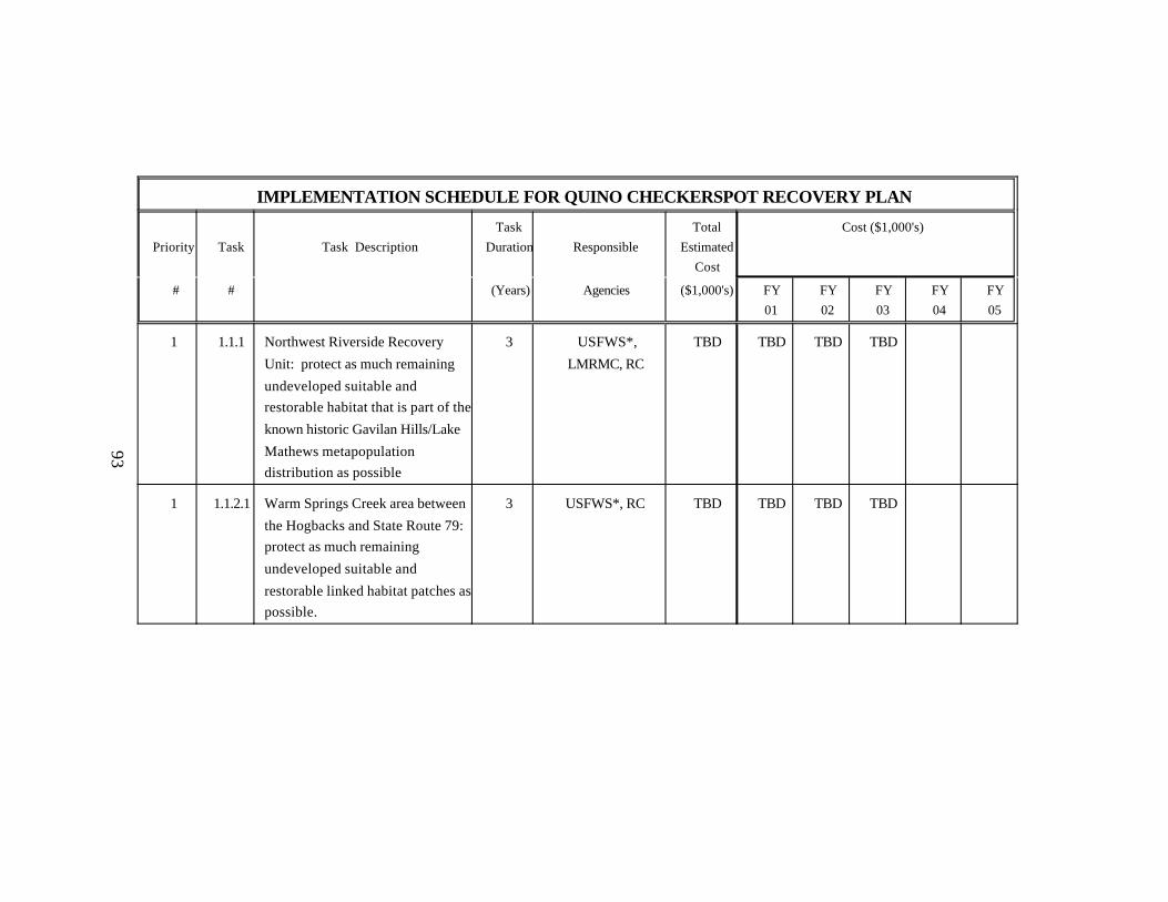
IMPLEMENTATION SCHEDULE FOR QUINO CHECKERSPOT RECOVERY PLAN
Priority Task Task DescriptionTask
Duration ResponsibleTotal
EstimatedCost
Cost ($1,000's)
# # (Years) Agencies ($1,000's) FY01
FY02
FY03
FY04
FY05
1 1.1.1 Northwest Riverside Recovery
Unit: protect as much remaining
undeveloped suitable andrestorable habitat that is part of the
known historic Gavilan Hills/Lake
Mathews metapopulationdistribution as possible
3 USFWS*,
LMRMC, RC
TBD TBD TBD TBD
1 1.1.2.1 Warm Springs Creek area between
the Hogbacks and State Route 79: protect as much remaining
undeveloped suitable and
restorable linked habitat patches aspossible.
3 USFWS*, RC TBD TBD TBD TBD
93

IMPLEMENTATION SCHEDULE FOR QUINO CHECKERSPOT RECOVERY PLAN
Priority Task Task DescriptionTask
Duration ResponsibleTotal
EstimatedCost
Cost ($1,000's)
# # (Years) Agencies ($1,000's) FY01
FY02
FY03
FY04
FY05
1 1.1.2.2. Lake Skinner and Johnson Rancharea: protect as much remaining
undeveloped suitable and
restorable linked habitat patches aspossible.
3 USFWS*, RC, UCR TBD TBD TBD TBD
1 1.1.3. South Riverside Recovery Unit: protect as much remainingundeveloped suitable and restorablelinked habitat patches within andbetween the two habitat complexes aspossible
3 USFWS*, BLM, SDC TBD TBD TBD TBD
1 1.1.4. South Riverside/North San DiegoRecovery Unit: protect as much asremaining undeveloped suitable andrestorable habitat patches within andbetween the two habitat complexes aspossible.
3 USFWS*, BLM, RC,SDC
TBD TBD TBD TBD
1 1.1.5.1. Protect and manage landscapeconnectivity through Proctor Valleybetween the habitats in San DiegoNational Wildlife Refuge and the OtayLakes area.
2 USFWS*, SDC TBD TBD TBD
94

IMPLEMENTATION SCHEDULE FOR QUINO CHECKERSPOT RECOVERY PLAN
Priority Task Task DescriptionTask
Duration ResponsibleTotal
EstimatedCost
Cost ($1,000's)
# # (Years) Agencies ($1,000's) FY01
FY02
FY03
FY04
FY05
1 1.1.5.2. Otay Lakes habitat complex: Protectand manage as much remainingundeveloped suitable and restorablehabitat that is part of the knownhistoric population distribution (Figure2) as possible, in a configurationdesigned to support a stablepopulation. Enhance landscapeconnectivity along the western andeastern margins of Otay Lake.
4 USFWS*, SDC TBD TBD TBD TBD TBD
1 1.1.5.3. Otay Mesa habitat complex: Protectand manage mesa areas contiguouswith the Otay River Valley. Enhance landscape connectivity between thenorth rim (above the Otay River) andwestern mesa top of Otay Mesa.
TBD USFWS*, SDC TBD
1 1.1.5.4. Otay Mountain Foothills habitatcomplex: protect and manage as muchremaining suitable and restorablehabitat that is part of the knownpopulation distribution.
3 USFWS*, SDC TBD TBD TBD TBD
95

IMPLEMENTATION SCHEDULE FOR QUINO CHECKERSPOT RECOVERY PLAN
Priority Task Task DescriptionTask
Duration ResponsibleTotal
EstimatedCost
Cost ($1,000's)
# # (Years) Agencies ($1,000's) FY01
FY02
FY03
FY04
FY05
1 1.1.5.5. Marron Habitat Complex: protect andmanage, in cooperation with publiclandowners, as much remainingsuitable and restorable habitat that ispart of the known populationdistribution as possible.
3 USFWS*, SDC,USFS, CSD, BLM
TBD TBD TBD TBD
1 1.1.5.6. Tecate habitat complex: protect andmanage as much remaining suitableand restorable habitat that is part of theknown population distribution aspossible.
2 USFWS*, SDC TBD TBD TBD
1 1.1.6. Southeast San Diego Recovery Unit: protect as much remainingundeveloped suitable and restorablelinked habitat patches as possible
3 USFWS*, CDPR,SDC
TBD TBD TBD TBD
1 1.2.1.1. All Recovery Units: Determine wherehabitat patches and linkage areaswould most effectively connectoccupied habitat patches.
TBD USFWS*, SDC TBD
1 1.2.1.2. Restore intervening habitat patches andremove any barriers from linkageareas. Start with Vista Murrieta High School and Johnson Ranch areas (in 2-3 years).
TBD USFWS*, SDC TBD TBD TBD TBD TBD TBD
96

IMPLEMENTATION SCHEDULE FOR QUINO CHECKERSPOT RECOVERY PLAN
Priority Task Task DescriptionTask
Duration ResponsibleTotal
EstimatedCost
Cost ($1,000's)
# # (Years) Agencies ($1,000's) FY01
FY02
FY03
FY04
FY05
1 1.2.2. Remove cattle and phase in weedcontrol where habitat is currentlygrazed.
2 USFWS*, CSD, CDF,BLM
TBD TBD TBD
1 1.2.3. Restore and manage degraded habitatpatches occupied by larvae.
Ongoing USFWS*, CDF,CDPR, BLM,
LMRMC, RC, SDC
TBD TBD TBD TBD TBD TBD
1 1.3. Erect barriers to prevent dispersal fromhabitat patches into adjacent high-traffic surface roads.
3 CalTrans*, RC, SDC,USFWS
TBD TBD TBD TBD
1 1.4. Reduce off-road vehicle activity withinthe distribution of described habitatcomplexes.
Ongoing USFWS*, CDF,CDPR, BLM,
LMRMC, RC, SDC
TBD TBD TBD TBD TBD TBD
1 2.1. Design and conduct yearly statusreviews/monitoring of habitatcomplexes or identifiedmetapopulations for 15 or more years.
Ongoing USFWS*, CDFG 200 10 10 10 10 10
1 2.2. Augment lowest density populations asneeded to help establish stability.
3 USFWS*, UCR TBD TBD TBD TBD
1. 3. Establish and maintain a captivepropagation program.
Ongoing USFWS*, UCR 1,162 6 6 130 60 60
1 4.1. Develop and implement the proposedVista Murrieta High School educationproject.
Ongoing USFWS*, UCR, VistaMurrieta High School
2,150 130 130 105 105 105
97

IMPLEMENTATION SCHEDULE FOR QUINO CHECKERSPOT RECOVERY PLAN
Priority Task Task DescriptionTask
Duration ResponsibleTotal
EstimatedCost
Cost ($1,000's)
# # (Years) Agencies ($1,000's) FY01
FY02
FY03
FY04
FY05
1 4.2. Initiate a pilot program similar to thatproposed for Vista Murrieta HighSchool in the Otay area, associatedwith the San Diego National WildlifeRefuge complex.
Ongoing USFWS*, UCR, VistaMurrieta High School
2,150 130 130 105 105 105
1 4.3. Initiate further cooperative outreachefforts with local nongovernmentalorganizations, educational institutions,and local museums.
Ongoing USFWS*, UCR 0 0 0 0 0 0
1 5.1 Conduct preliminary modeling ofmetapopulation dynamics for theSouthwest Riverside and SouthwestSan Diego Recovery Unit habitatcomplexes.
3 USFWS* 20 10 5 5
2 5.2. Investigate the function of hilltops as aresource for Quino checkerspotpopulations.
2 USFWS* 8 0 8
2 5.3. Investigate the contribution ofmultiple-year diapause tometapopulation stability.
6 USFWS* 35 10 5 5 5 5
2 5.4. Monitor populations for furtherevidence of climate-driven rangeshifts.
Ongoing USFWS* TBD TBD TBD TBD TBD TBD
98

IMPLEMENTATION SCHEDULE FOR QUINO CHECKERSPOT RECOVERY PLAN
Priority Task Task DescriptionTask
Duration ResponsibleTotal
EstimatedCost
Cost ($1,000's)
# # (Years) Agencies ($1,000's) FY01
FY02
FY03
FY04
FY05
2 5.5. Determine the effect of elevatedatmospheric carbon dioxide andnitrogen.
3 USFWS* 120 40 40 40
2 5.6. Survey areas between and aroundhabitat complexes to determine wherethere is intervening and/or additionallandscape connectivity.
TBD USFWS* TBD
2 5.7. Map habitat complex attributes TBD USFWS* TBD
2 5.8. Northwest Riverside Recovery Unit: Investigate the possibility of remainingoccupied or suitable habitat proximalto the (subsequently developed) Quinocheckerspot population near Murrieta
3 USFWS* 36 12 12 12
2 6 Manage activity on trails where habitatoccurs in recreational use areas,particularly during the active seasonfor Quino checkerspot larvae andadults (i.e. November through May)
Ongoing USFWS*, RC,LMRMC, SC, CDPR
TBD TBD TBD TBD TBD TBD
2 7. Locate or introduce two populations ormetapopulations in the remainingundeveloped coastal areas of the Quinocheckerspot’s historic range.
TBD USFWS*, USMCCP,USMCASM, CSD
TBD
2 8. Reduce fire frequency and illegal trashdumping in habitat areas
Ongoing USFWS*, RC, SDC,BLM
TBD TBD TBD TBD TBD TBD
99
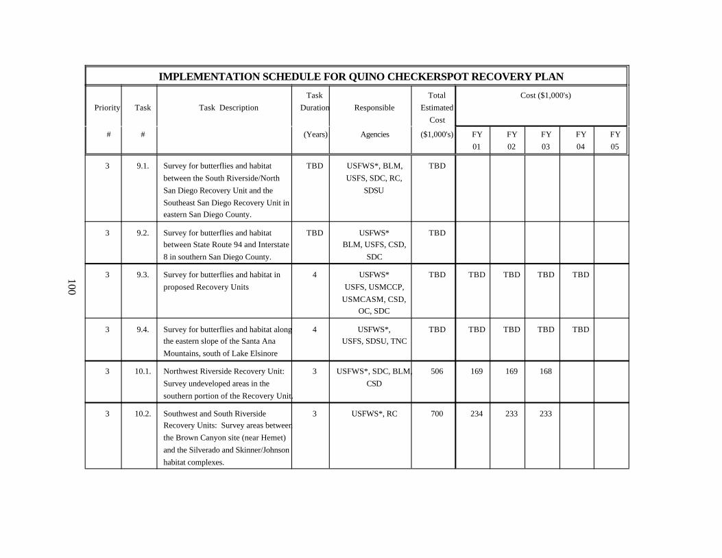
IMPLEMENTATION SCHEDULE FOR QUINO CHECKERSPOT RECOVERY PLAN
Priority Task Task DescriptionTask
Duration ResponsibleTotal
EstimatedCost
Cost ($1,000's)
# # (Years) Agencies ($1,000's) FY01
FY02
FY03
FY04
FY05
3 9.1. Survey for butterflies and habitatbetween the South Riverside/NorthSan Diego Recovery Unit and theSoutheast San Diego Recovery Unit ineastern San Diego County.
TBD USFWS*, BLM,USFS, SDC, RC,
SDSU
TBD
3 9.2. Survey for butterflies and habitatbetween State Route 94 and Interstate8 in southern San Diego County.
TBD USFWS*BLM, USFS, CSD,
SDC
TBD
3 9.3. Survey for butterflies and habitat inproposed Recovery Units
4 USFWS*USFS, USMCCP,
USMCASM, CSD,OC, SDC
TBD TBD TBD TBD TBD
3 9.4. Survey for butterflies and habitat alongthe eastern slope of the Santa AnaMountains, south of Lake Elsinore
4 USFWS*,USFS, SDSU, TNC
TBD TBD TBD TBD TBD
3 10.1. Northwest Riverside Recovery Unit: Survey undeveloped areas in thesouthern portion of the Recovery Unit.
3 USFWS*, SDC, BLM,CSD
506 169 169 168
3 10.2. Southwest and South RiversideRecovery Units: Survey areas betweenthe Brown Canyon site (near Hemet)and the Silverado and Skinner/Johnsonhabitat complexes.
3 USFWS*, RC 700 234 233 233
100

IMPLEMENTATION SCHEDULE FOR QUINO CHECKERSPOT RECOVERY PLAN
Priority Task Task DescriptionTask
Duration ResponsibleTotal
EstimatedCost
Cost ($1,000's)
# # (Years) Agencies ($1,000's) FY01
FY02
FY03
FY04
FY05
3 10.3. South Riverside/North San DiegoRecovery Unit: Survey areas south ofthe Silverado habitat complex and theOak Grove site.
2 USFWS*, RC, BLM 363 182 181
3 10.4. Southeast San Diego Recovery Unit: Survey areas west, north, and east ofthe Jacumba habitat complex.
2 USFWS*, RC, BLM 228 114 114
3 11. Enter into dialogue with BajaCalifornia, Mexico nongovernmentalorganizations and local governments.
2 USFWS TBD TBD TBD
3 12. Enter into dialogue with the CahuillaBand of Mission Indians
2 USFWS TBD TBD TBD
Total Estimated Cost of Recovery Through FY 2020: $7,678,000 +
101

102
APPENDIX IQuino Checkerspot Butterfly Life Cycle Diagram
Prepared by Dr. Gordon Pratt. Photographs by Greg Ballmer.
Reproduced with permission from the authors.
This diagram represents the typical life cycle. There is overlap in the life stagesdue to population variability. Seasonal timing is also variable, depending onannual fluctuations in climate (particularly precipitation). Photographs are not toscale.

103
Insert life cycle picture. (Pdf tif)

104
APPENDIX II
Habitat Restoration MethodsPrepared by Mark Dodero
The conservation and recovery of the Quino checkerspot butterfly requires notonly the preservation of currently suitable, but also the restoration of degraded,habitat for re-establishment of fully functioning metapopulations. Stabilizationand re-establishment of the species (within even a small fraction of its historicrange) will require long-term restoration and management efforts, possibly inperpetuity. This article discusses a variety of methods involved in, and issuesrelated to, restoration, including: restoring occupied habitat; removing andcontrolling nonnative (or native) plant species; preparing the site; selectingnative plant species; collecting native plant seed; restoring cryptogamic crusts;using salvaged materials; monitoring and maintaining the restored habitat,implementing adaptive management techniques; and the potential costsassociated with these activities.
Restoring Occupied Habitat A primary goal of most habitat restoration programs is to connect and enlargesuitable habitat patches by removing nonnative plants in adjacent areas. Specialprecautions need to be taken if the site is occupied by the Quino checkerspot orother listed species. Usually, workers should begin removing nonnative plants atthe center of occupied habitat patches and work outward, concentricallyenlarging and connecting the habitat patches. This work will require on-sitemonitoring by a biologist familiar with the distribution of Quino checkerspot andother listed or sensitive plant and animal species.
Nonnative plant removal strategies should be site-specific to take advantage ofhabitat breaks such as those created by large shrub patches, canyon edges, rockoutcrops, or roads. These breaks can serve as buffer zones from adjacent areasthat are dominated by nonnative plants. Designing the complete restoration ofmetapopulation habitat patch networks by taking advantage of existing breakswill enable managers to use nonnative plant removal funds most efficiently.Initially concentrating efforts in occupied habitat patches will improve the

105
habitat quality until resources are available to restore larger areas. Afternonnative plant removal, populations of native annuals may be enhanced orre-established in and between existing habitat patches by hand seeding.
Restoring Occupied Habitat Dominated by Nonnative Plants when NativeSpecies are Still Present
Native plant communities invaded by nonnative species can be weeded usingdifferent methods, depending on the site conditions and the presence of sensitiveresources. Some habitat patches will require only spot herbicide spraying, andpossibly hand removal of individual nonnative plants. Other methods can alsobe used, although some nonnative plant control methods, such as the use ofpre-emergent or other herbicides, may not be appropriate in Quino checkerspothabitat. Site-specific nonnative plant control strategies will be needed. Timingof nonnative plant control efforts is crucial to success. If nonnative plants arenot killed prior to seed set, then removal effort and cost will remain high overtime. Another crucial component of the nonnative plant removal methoddescribed below is that workers must be trained to distinguish between nativeand nonnative plants for restoration to be successful.
This method of restoring native plant communities described below, involvingremoval of dead plant thatch using hand tools and “weed eaters,” and returnvisits for spraying with glyphosate (a selective herbicide), appears to besuccessful on sites in central and southern San Diego County. Thick thatch canprevent native species from germinating and/or competing successfully for lightand space with nonnatives.
If nonnative plants are present at moderate to high levels in areas that still havesignificant numbers of native species present, the following de-thatchingtechnique can be used to restore or enhance these sites. De-thatching should beused in areas that have a buildup of organic matter on the soil surface, such asdead mustard or annual grasses.
De-thatch and Repeat Spray Method (in order):

106
• Cut thatch and dead nonnative plants with "weedeaters." This cutting can bedone during the summer or early fall.
• Rake up and collect nonnative plant thatch.• Remove thatch from site and dispose of it in dumpsters, a landfill, or an area
where it can be composted nearby to reduce disposal costs.• Return to site and spray Roundup (or more selective herbicide) on nonnative
plant seedlings after sufficient rains have fallen in winter and spring.• Repeat spraying as necessary to prevent seed set. Other options include the
use of pre-emergent herbicide prior to the first significant rain.• Repeat spraying as necessary to maintain nonnative plant density to a low
level. If nonnative plants are controlled each season prior to flowering andsetting seed, the level of effort required should decrease.
The nonnative plant removal process must be carefully monitored becausefrequently, as the dominant nonnative plant species are removed, other nonnativeplant species multiply rapidly and replace the formerly dominant nonnativespecies. Repeated nonnative plant removal visits are necessary, and adaptivemanagement strategies must quickly address control of newly dominantnonnative species. Frequent site visits are necessary during the growing seasonto assess nonnative plant removal efforts and to determine whether changes areneeded in the strategy being used or the intensity of nonnative plant removalefforts. This type of nonnative plant removal effort requires control efforts priorto flowering and seed development. As nonnative plants are controlled over thefirst few years, natives will return to dominance. Removal of nonnative plantsby hand may be required around small populations of herbaceous natives. Expansion of herbaceous annuals, including goldfields (Lasthenia) and plantain(Plantago), which may be locally rare because of nonnative plant competition,may require population augmentation and careful hand removal of nonnatives.
Restoring Unoccupied Habitat Completely Dominated by Nonnative Plants
If nonnative plants dominate a heavily disturbed restoration site completely (fewor no native plant species occur) and the thatch is well incorporated into the soil,it can be more cost-effective to use heavy equipment over a large area to removethatch and nonnative plant seed banks. Soil scraping probably works best ifthere are existing patches of native habitat adjacent to the site to allow

107
immigration of native flora and fauna. This type of nonnative plant controltechnique can be used for fallow agricultural fields. Bulldozers or othermechanical scraping equipment can be used to remove the top organic thatch-covered layers of soil (a few inches or more if necessary. The goal of scraping isto reach the upper sub-soil, which does not have organic buildup, unnaturallyhigh nutrient levels, or nonnative plant seeds. Soil can be removed from the siteand used as fill. If the soil cannot be removed from the site, it should be deeplyburied to reduce the likelihood of nonnative plant seed dispersal.
After scraping away the thatch and the top organic layers of soil, salvagedtopsoil with a minimal nonnative seedbank can be obtained from other areas andcan be spread over the restoration site. This procedure will provide the site withsoil microorganisms, fungi, invertebrates, and seeds of native species. Afterscraping, winter rains will cause nonnative weed seeds to germinate, requiringnonnative plant control efforts. Repeat spraying visits can be used as describedabove and can be very effective, especially if used in conjunction withhigh-quality salvaged topsoil.
Heavily disturbed habitats that have not been used for agriculture may containnative plant species such as bunchgrasses and bulbs. To evaluate what methodsshould be used to remove weed thatch from a site, it is important to visit the siteduring the spring prior to scraping to determine whether native bulbs or otherspecies are present. These native plants might be missed during a summer visit. This problem should not exist for agricultural fields, only for heavily disturbedareas that were not farmed and may still have natives. If small numbers of nativeplants are present, they can be avoided or salvaged prior to scraping and thenreplanted or used for propagation. If no undisturbed areas exist adjacent to thesite, or if significant numbers of native species are present, the area should bede-thatched with hand tools as described above to reduce the impacts of weedremoval on the soil fauna. It is important that nonnative plant control methodsminimize impacts to the native invertebrate fauna.

108
Native Plants for Habitat Restoration and Enhancement
Seeds of native plant species used in each restoration project should be locallycollected whenever possible. If a plant species was historically present in anarea but can no longer be found, it should be reintroduced from the localitynearest the restoration site. Local collection of seed is especially important withregard to Quino checkerspot host and nectar plants, but should be done for asmany other species as possible. Locally adapted plants are better competitorsthan plants introduced from a different climate zone. Seed collection shouldgenerally occur within 8 kilometers (5 miles) of a proposed restoration orenhancement site. If collecting within this distance is not possible, it is best tocollect seeds as close as possible within the same general climate zone. Generalclimate zones outlined in the Sunset Western Garden Book (Sunset PublishingCorporation 1995) can be used as a guide. Reciprocal transplant experimentshave shown that plants of genotypes that are not locally adapted are inferiorcompetitors when they are moved to a different climate zone. In addition,introducing plants that are not locally adapted can be detrimental to localherbivorous insects.
Much of the plant material required for restoration of Quino checkerspot habitatwill include annuals and bulbs. Many of these species will be difficult to collectfrom the wild in sufficient quantity to seed the restored areas. Collecting fromthe wild must be limited so it will not adversely affect source plant populations.To ensure that adequate seed is available, seed bulking (growing seed incultivation to increase the amount of seeds) of annuals, including Plantago andnectar plants, will be necessary. This seed bulking should be done at growingareas that can provide reproductive isolation from related plants from differentregions. Plants from different source regions should not be allowed to hybridizeat a common growing facility, but locally adapted genotypes for plants should bemaintained as much as possible. It can take 3 years to grow bulbs from seed to asize large enough to plant and still have high survivorship when they are plantedout. Therefore, restoration of diverse grassland sites, for instance, can requireseveral years of planting.
109
Enhancement of Pollinator Populations
Providing adequate habitat for pollinator assemblages is crucial to the success ofany Quino checkerspot restoration project. Pollinators are required to ensure thatQuino checkerspot nectar plants have high seed set and persist over the longterm. In arid environments, many potential pollinators, including native beespecies, require open ground for nesting (Buchmann and Nabhan 1996).Extensive nonnative plant cover continues to invade and dominate current andhistoric Quino checkerspot habitat in Southern California, resulting in a loss ofopen ground suitable for ground nesting pollinators. By reducing availablenesting sites, the nonnative plant growth is causing a decline in pollinatornumbers and diversity, with negative implications for the entire ecosystem.
As well as reducing the extent of open areas required for ground nestingpollinators, competitive interactions between nonnative and native plant species,including dwarf plantain (Plantago erecta), goldfields (Lasthenia sp.), bulbs, andrare plants are causing declines in the biological diversity of naturalcommunities. In order to support a diverse assemblage of potential pollinatorsand native plant species, areas of open ground within associated native plantcommunities must be restored to support ground nesting bees and otherinvertebrates. The goal of having open ground for pollinators is compatible withQuino checkerspot restoration efforts because Quino checkerspot larval food andadult nectar plants require open ground for successful reproduction andlong-term persistence.
Restoration plantings should include nectar-producing plant species withoverlapping flowering periods that extend throughout the typical SouthernCalifornia growing season. Although there are exceptions, in general many ofthe nectar producing plants of arid Southwest environments (including coastalsage, grasslands and vernal pools habitats in Southern California) are visited bygeneralist pollinating insects (Buchmann and Nabhan 1996). Generalistpollinators visit more than one plant species for their nectar and pollen. Tosupport pollinator assemblages throughout the flowering season,re-establishment and enhancement of nectar-producing plant populations may berequired as part of restoration efforts. Even though a primary goal of Quinocheckerspot habitat restoration is to enhance nectar resources specifically used

110
by Quino checkerspot, generalist pollinators may require additional temporallyoverlapping nectar resources to support their populations throughout the year. At a minimum, restoration should include several nectar-producing plant speciesthat in combination flower from early spring through late summer, as seen inrelatively undisturbed natural ecosystems in Southern California.
For example, species that provide good nectar resources include goldfields(Lasthenia sp.) and tidy tips (Layia sp.), which flower in early spring; gumplant(Grindelia sp.), which flowers later but overlaps with goldfields; and other herbssuch as tarplants (Hemizonia sp.) and shrubby species such as goldenbush(Isocoma sp.), which flower in late spring and during the summer. There-establishment of these or other appropriate species on a restoration project sitewill provide a continuous nectar source to keep local pollinator assemblagessupplied with resources until the fall, when many pollinating insects becomedormant or enter another phase of their life cycle. Each region will has its ownset of nectar-producing plants, and restoration projects should be designed on asite-specific basis with the goal of supporting viable populations of potentialpollinators.
Restoration of Cryptogamic Crusts
Although the science of restoring cryptogamic crusts is still in its infancy and theregeneration process requires a long time for full development, there are knowntechniques to promote conditions that are appropriate for the growth of thesebiotic crusts. Observations of older disturbed habitat in San Diego County andelsewhere indicate that soil crusts can recover following a disturbance. Theprocess takes many years and proceeds more slowly in xeric environments thanin more mesic sites. Redevelopment of biotic crust on disturbed sites is likely toproduce more species diversity when intact soil crusts exist adjacent to thedisturbed area. Moisture and soil conditions are the most important factors toconsider when promoting crust growth.
Belnap et al. (1999) listed five factors that increase moisture on the soil surfaceand therefore promote crust development: 1) closely spaced plants; 2) flat areas(depositional surfaces rather than erosional surfaces); 3) limited surface rocks,roots, or light plant litter to slow water and wind; 4) soils with inherently high
111
stability (silt/clay>sandy>shrink-swell clay); and 5) stable microhabitats (undershrubs, away from small washes). As soil stability increases and human-relateddisturbances decrease, rich communities of cyanobacteria, mosses, and lichensbecome more widespread, covering all surfaces not occupied by vascular plantsand rocks.
Recent attempts have been made to reintroduce soil crust organisms torestoration sites on Otay Mesa, in San Diego County. Crust organisms such asashy spike-moss (Selaginella cinerascens) and other associated crust flora suchas liverworts, mosses, fungi, and lichens have been salvaged from recentlydeveloped areas and planted into restoration sites. One way to translocate spike-moss is to cut it into squares about the size of a greenhouse flat using hand toolsand place the squares into the flats for transport or temporary storage. Whensoils at the restoration site are moist, the spike-moss can be planted into shallowholes excavated in the shape of the flat. The spike-moss is planted in the hole sothat it is flush with or slightly below the surrounding soil surface. Thisplacement reduces the chance that erosion will break apart the crust. New crustorganisms have been grown on a small scale by placing salvaged native topsoilin greenhouse flats and then keeping them continually moist in a shaded growingstructure.
These small-scale biotic crust restoration trials have produced actively growingliverworts, mosses, and ashy spike-moss. Large-scale production could be usedto grow many units of crust, which can be planted at the restoration sites afternonnative plants are removed or under control. Salvaged brush is also beingused to promote the growth of crusts by placing branches on open ground afterthe site is well weeded. The branches alter the soil moisture conditions byreducing evaporation. Mosses and algae have been observed growing under thebranches within 1 year after the branches have been put in place. Future effortsto promote crust development will include salvaging crust from developmentimpact sites during the summer dry season and then using the powdered dry soilsto sprinkle over stable soil areas that are lightly covered with branches.
Using Salvaged Materials
Topsoil
112
Salvaged topsoil can also be used from nearby construction sites to enhance therestoration areas, including bringing in native plant propagules and soil fauna.Topsoil should only be salvaged from areas that are not infested with nonnativeplants. Salvaged topsoil must be placed at the recipient site as soon as possibleto maintain the maximum diversity of seeds and other soil organisms. Thegreatest chance of success in using salvaged topsoil is to collect soil in thesummer or early fall dry period. If soils are wet when moved and spread greaterdamage to the native seed bank and soil organisms will occur than if the soil isdry and organisms are dormant. Soil should be stockpiled only if absolutelynecessary because the longer the soil is stored the greater the loss of seeds andsoil fauna. If soil must be stockpiled, it should be kept dry. The depth of piles instorage should not exceed 90 centimeters (3 feet) to avoid composting effects,and a depth of 30 to 60 centimeters (1 to 2 feet) is preferable for maintainingseed banks. The topsoil translocation site should be prepared prior to topsoildelivery.
Brush and Rocks
The following techniques can be used to increase the structural diversity of therestoration area to provide cover sites for invertebrates, including Quinocheckerspot. Brush piles, scattered sticks, branches, and rock cobbles can bebrought to the restoration site to increase the available cover for many animals,and will provide potential diapause and pupation sites for Quino checkerspot.Brush can be obtained from nearby construction sites, either from brush habitataffected by development or from brush management activities adjacent tostructures. Because brush material is considered a waste product and has to bechipped and removed to a landfill, most construction supervisors will truck thematerial to your restoration site if it is near the construction area. This approachcan save the developer costs associated with trucking the material to a landfill.Creative partnerships with developers can result in increased structural diversityof your restoration site.
Placement of decaying wood and brush in the restoration site can provideimmediate cover for many animals, including larvae and pupae of Quinocheckerspot. By bringing in brush and rocks (if appropriate to the specific site)it is possible to "jump start" restoration by providing cover that would take many

113
years to develop or accumulate otherwise. The use of one or two restorationenhancement techniques, such as placement of brush and rocks, can benefitmultiple species when done using an integrated ecosystem approach. Forexample, brush piles and sticks, which should benefit Quino checkerspot, canalso provide food for termites that are the primary food source for orange-throated whiptails, a sensitive species likely to be included in a multiple speciesconservation program. The use of structural enhancement techniques thatbenefit multiple species will increase the chance of successful implementation ofrestoration for multiple species habitat conservation plans.
Native Plants
Many species of native plants can be salvaged from construction impact areasprior to development. Translocation of native shrubs and herbaceous perennialsis most successful under cool moist weather conditions after rains have startednative plant growth and just prior to anticipated rainfall. Bulbs can be excavatedfrom the soil as they become dormant in late spring after flowering has ceased. Bulbs can be stored until the fall when they can be planted after significant rains.
Restoration Costs
Habitat restoration costs vary per site, depending on site preparation costs,maintenance and monitoring requirements and the number of sensitive speciesneeded to be present reintroduced and managed for to meet specific projectstandards. For Quino checkerspot restoration, maintenance of the site should lasta minimum of 5 years, probably longer for converted agricultural fields, with amonitoring period of 10 years before determination of project success formitigation purposes. Many of the degraded habitats will require at least 3 yearsof restoration work before reintroduction of the Quino checkerspot can beinitiated. In sites that have been completely reconstructed, such as formeragricultural fields, at least 15 years will be required to determine if efforts tore-establish Quino checkerspot have been successful.
De-thatching and Herbicide Spraying

114
Costs associated with removing thatch and spraying nonnative plants with aselective herbicide vary among restoration sites, but depend primarily on thedegree to which the natural habitat has been degraded, including the extent ofnonnative plant invasion. The cost of removing nonnatives is generally lowestfor areas that require only spot spraying of individual plants. Removing plantsby hand is costly, especially for large areas. However, hand "weeding" may benecessary for sites occupied by Quino checkerspot. The de-thatching techniquecan be used in conjunction with return visits to spray individual nonnative plants;and in some instances a “weed eater” can be used instead of spraying.
The de-thatching technique is typically used only during the first year as part ofthe site preparation. A crew of approximately ten workers has been used to de-thatch nonnative plants, accomplishing several tasks simultaneously. Activitiesinclude weed-whipping the site (4-5 weed-whips can work at one time), rakingthatch into piles, collecting thatch and placing it into burlap bundles, and takingthe bundles to trucks for removal from the site. Estimated costs per unit area aregiven below for using the de-thatch and repeat spraying method for sitesdominated by nonnative plants, but which still have native plants present.
Using this method, 10 workers can de-thatch approximately 0.4 hectare (1 acre)per day. Costs for the de-thatching range from $4,000 to $5,000 per hectare($1,600 to $2,000 per acre) (based on a average $20 per hour billing rate for thelaborers and supervision time). The work can be physically demanding,especially if the thatch material has to be hauled out of steep canyons. Ifremoving the material is not possible, it can be placed into piles and compostedon the site. The nonnative plants that germinate later from the piles will need tobe controlled because some nonnative plant seeds will remain. After sufficientrains have fallen in winter, nonnative plant seedlings will require control byreturn visits to spray Roundup© or other, more selective, herbicides to preventthe plants from maturing and producing seeds. Care must be taken to minimizeover-spray onto native species. It is imperative that workers are able torecognize nonnative plants and distinguish them from native plants.
For the first 2 seasons after de-thatching, repeat spraying with an appropriateherbicide up to five times in a season costs approximately $8,400 per hectare($3,400 per acre)in labor (four workers making five spraying visits) and an

115
additional cost of approximately $500 per hectare ($200 per acre) for herbicide(to spray the entire area once). The amount of spray required will be reduced asthe season progresses and fewer nonnative plants are present. After the first 2years, weeding costs decrease each year if the spraying program is timed to killthe nonnative plants before they set seed. Approximate costs of subsequentyears relative to the first year of restoration activities are as follows: year 3, 75percent; year 4, 50 percent; year 5, 33 percent. These proportions of decreasingcosts are approximate and will depend on how weedy the site is initially and howdiligently follow-up nonnative plant control efforts are completed. If nonnativesare not killed prior to seeding, costs will not decrease as anticipated. Thebiologist monitoring the project must ensure that subcontractors or volunteerscomplete work on schedule and that nonnative plants are controlled prior to seedset for the effort to be effective.
For Quino checkerspot preserve areas, periodic maintenance will likely berequired at low levels in perpetuity after the area is turned over to a long-termsite manager. The ultimate goal of restoration efforts is to create self-sustainingQuino checkerspot habitat areas. However, management endowments willlikely be needed indefinitely to fund periodic nonnative plant control activitiesand other habitat management tasks.
One restoration planning strategy to reduce long-term management costs isensuring that native species occupy the newly opened ground as nonnative plantsare controlled. Established native plants provide resistance to nonnative plantinvasion because the space is already occupied, but careful planning is requiredto ensure that appropriate plant species are selected for the restoration sites. Forexample, certain native shrub species can quickly outcompete small herbaceousannuals such as plantain (Plantago) and goldenbush (Lasthenia), which areimportant to Quino checkerspots. Shrubs, including California sagebrush(Artemisia californica), can quickly dominate a restoration site recently openedup by nonnative plant control efforts if the sagebrush are seeded densely or arepresent in adjacent areas.
Many restoration projects tend to encourage growth of native species thatprovide fast-growing shrub cover. Many restoration and revegetation projectsrequire quick cover to minimize erosion. However, the goal of providing dense

116
cover is quite different from the goals of a Quino checkerspot restoration projectbecause areas intended for Quino checkerspot must remain open. Therefore,careful selection of plant material must be incorporated early in the restorationplanning process. If not carefully planned, a restoration site can be inadvertentlydirected toward rapid succession from open ground to dense shrub cover, ahabitat unsuitable for Quino checkerspot. Long-term needs of the Quinocheckerspot must be considered in the restoration planning process. Forexample, a site that appears suitable for Quino checkerspot after 2 or 3 yearscould be completely dominated by shrubs in 10 years if the project is not plannedcorrectly or appropriate maintenance is not conducted. In this situation, the sitewould no longer provide suitable habitat because shrub density would beexcessive. To avoid losing recently restored habitat, long-term monitoring ofQuino checkerspot restoration sites and remedial measures implemented to slowor reverse succession will be needed.
Total Costs Of Habitat Restoration Maintenance and Monitoring
In addition to nonnative plant removal and control costs, restoration efforts forheavily disturbed sites may also include costs for additional site preparation. This preparation may include grading or recontouring the soil to reconstructmima mound topography in former vernal pool areas that have been disturbed byagricultural activities, off-road vehicle traffic, or grazing. Costs for the transportand placement of rock cobbles may be included if appropriate to the site. Forcomplete reconstruction of Quino checkerspot habitat (site preparation andimplementation, plant production, planting, weeding, monitoring and annualreporting) the costs can range from $75,000 to $125,000 per hectare ($30,000 to$50,000 per acre) (or possibly more for agricultural fields) for 5 years ofmaintenance and monitoring. Existing occupied or unoccupied habitat that isrelatively intact (with mostly native species) will be less expensive and mayrange from $12,000 to $50,000 per hectare ($5,000 to $20,000 per acre)depending on the specific site conditions.
Adaptive Management
Adaptive management strategies should be used to deal with unforeseencircumstances. This flexibility is especially important in restoration sites that

117
require complete reconstruction from old agricultural fields. Adaptivemanagement can include management/control of selected native species, such asCalifornia sagebrush or other native plant species in Quino checkerspotrestoration sites, so that they don't dominate the vegetation. Until theappropriate Quino checkerspot larval food and adult nectar plants are fullyestablished, monitoring and control of aggressive native species may be requiredin addition to controlling nonnative nonnative plants. Rapid succession from anopen-ground habitat to a dense shrub-dominated community can exclude Quinocheckerspot food plants through competition.
Restoration techniques such as heavy mulching of newly planted containers orentire sites are promoted by some ecologists but are usually inappropriate forsmall native annuals. Similarly, a heavy mulching strategy is not appropriate forrestoration of most rare annual and perennial herbs, or for Quino checkerspotfood plants, such as Plantago and Lasthenia. The use of light, natural mulchmade up of salvaged native sticks and branches is acceptable, but a thick mulchis unnecessary to grow many of the native shrubs and annuals.
Selected Literature
Belnap, J., J. Williams, and J. Kaltenecker. 1999. Structure and function ofbiological soil crusts. In Proceedings: Pacific Northwest Forest and RangelandSoil Organism Symposium. R. Meurisse et al. (eds.). U.S.D.A. PacificNorthwest Research Station, Portland, Oregon. PNW-GTR-461.
Buchmann, S. L., and G. P. Nabhan. 1996. The Forgotten Pollinators. IslandPress/Shearwater Books, Washington D.C. and Covelo, California.
Read, E. A. 1994. The importance of community classification to mitigationand restoration of coastal sage scrub. Restoration Ecology 2:80-86.
Sunset Book and Magazine Editors. 1995. Sunset Western Garden Book. Sunset Publishing Corporation, Menlo Park, California.

118
APPENDIX III
The Annual Forbland Hypothesis: An extinct vegetation type in remnant Quino habitat?
Prepared by Dr. Edith Allen.
The Quino checkerspot uses exotic annual grasslands that still have a componentof native forbs. It is likely that the bottomlands that have mostly been disturbedby agriculture and continuous grazing were once dominated by native forbsrather than exotic grasses. This hypothesis is controversial, as the potentialnatural vegetation of the Los Angeles Basin and the Riverside-Perris plain wasconsidered by Küchler to be coastal sage scrub (Barbour and Major 1977).However, early Spanish explorers such as de Anza in 1775 (from the diary ofFriar Font, translated by Bolton 1930) noted that this region had colorful fieldsof flowers. Similar observations were made during the late 1700's in northernBaja California; springtime brought a large diversity of colorful flowers to thebottomlands, while shrubs were mentioned for the hillier uplands (Minnich andFranco 1998). It is apparent that if these forblands once existed, they are now avirtually extinct vegetation type. A present day analogue to these forblandsexists in the California Poppy Reserve on the west edge of the Antelope Valley,and in the Carrizo Plain of the San Joaquin Valley. These areas are stilldominated by native wildflowers in the spring rather than shrubs or grassland,although exotics are a large component of the vegetation. By contrast, in thePerris Plain, Otay Mesa, and Marron Valley the exotic annuals dominate in thelowlands. Dwarf plantain (Plantago erecta) is often considered a plant of claysoils (although Jepson states that it ranges from sand to clay, and it occurslocally in decomposed granites). In areas where dwarf plantain is restricted toclay outcrops, it would be interesting to test the hypothesis that it is restrictedthere by weed competition.
Literature Cited
Barbour, M. G., and J. Major [Editors]. 1977. Terrestrial Vegetation ofCalifornia. Wiley-Interscience. New York. 1002 pp.

119
Bolton, H. E. 1930. Anza's California expeditions. v.4. Font's complete diaryof the Second Anza expedition Berkeley, Calif., University of California Press.
Minnich, R. A., and E. F. Vizcaíno. 1998. Land of chamise and pines: historicalaccounts and current status of northern Baja California's vegetation. Universityof California Press. Berkeley, California.

120
APPENDIX IV
Glossary of Terms
Diapause: A low-metabolic resting state similar to hibernation that enableslarvae to survive for months during the summer without feeding.
Ecological connectivity: The amount of undeveloped wildlands between twoareas. May or may not include landscape connectivity between habitat patches. Habitat areas or populations lacking ecological connectivity are termedcompletely isolated.
Extinction: Global disappearance of a species (or subspecies as used in thisrecovery plan).
Extirpation: Disappearance of a local population.
Forbland: A vegetation community dominated by forbs (broad-leavedherbaceous plants).
Habitat connectivity: The degree of fragmentation within habitat patches. Ifroads or other development occurs within a habitat patch to the point that adultscannot move freely between micro-patches of larval hostplants and otherrequired resources, then one habitat patch may effectively become two or morewith intervening areas becoming dispersal corridors or linkage areas that supportlimited exchange between habitat patches. Habitat patches with poor habitatconnectivity are termed fragmented, and are generally prone to higher levels ofongoing degradation.
Habitat complex: A spatially clustered set of confirmed Quino checkerspotobservation or collection records that delineate at least part of a currentlyundescribed population or metapopulation distribution.
Instar: The period between hatching from the egg to first molt (shedding skin) inlarvae, and between molts after that.

121
Landscape connectivity: The degree of linkage between habitat patches joinedby dispersal corridors or linkage areas. The number of linked habitat patchesand their distance from each other determines the landscape connectivity of anarea or a metapopulation. Habitat patches completely lacking landscapeconnectivity are termed isolated.
Larva: A caterpillar.
Larval hostplant: Any plant that caterpillars consume.
Metapopulation distribution: The maximum long-term “footprint” of ametapopulation. This is the area covered by a network of habitat patches (bothoccupied and temporarily not occupied by larvae), including all the habitatpatches that could be occupied by larvae over an approximate time-scale of 50years. It is assumed that long-term metapopulation stability requires butterflydensities periodically to reach their maximum, and therefore the maximumnumber of occupied habitat patches. The location of occupied habitat patcheswill shift from year-to-year, changing the shape of the extant footprint over time,but the metapopulation distribution does not change.
Mortality sink: A location where butterflies experience a high death rate.
Primary hostplant species: Species of hostplant on which adult femalebutterflies deposit eggs, and which caterpillars consume when they hatch.
Pupa: A chrysalis, sometimes mistakenly called a cocoon (cocoons are pupaewith an outer silken layer spun by moth caterpillars).
Secondary hostplant species: Species of hostplants that caterpillars consume, butadult female butterflies do not deposit eggs on.