osceola county - florida department of · osceola county’s population is projected to continue to...
TRANSCRIPT

INTEGRATION OF THE LOCAL MITIGATION STRATEGY INTO THE LOCAL COMPREHENSIVE PLAN
FLORIDA DEPARTMENT OF COMMUNITY AFFAIRS 5/23/2005
1
COUNTY PROFILE
OSCEOLA COUNTY The 2004 hurricane season underscores the importance of better integrating hazard mitigation activities and local comprehensive planning. This past fall, Floridians experienced significant damage from Hurricanes Charley, Frances, Jeanne, and Ivan. In 1992, Hurricane Andrew devastated South Florida. In 1998 and 1999, most counties in Florida experienced wildfires, and in some cases, the fires created devastating results – the loss of homes. The cost of recovery for these various disasters ranges from hundreds of thousands to billions of dollars, significantly taxing local, State, and Federal financial sources. Losses covered through Federal funding as a result of the 2004 hurricanes alone could reach as high as $7 billion. It is imperative to try to reduce the costs of natural disasters. One way is to better integrate hazard mitigation considerations into local comprehensive planning. Contents: 1. County Overview
2. Hazard Vulnerability 3. Existing Mitigation Measures 4. Comprehensive Plan Review 5. Recommendations 6. Sources
1. County Overview Geography and the Environment Osceola County is located in central Florida. It covers a total of 1,322 square miles with an average population density of 130.5 people per square mile (U.S. Census, 2000). There are two incorporated municipalities within the County: Kissimmee and St. Cloud. Population and Demographics Official 2004 population estimates for all jurisdictions within Osceola County, as well as, the percent change from the 2000 U.S. Census are presented in Table 1.1. The most current estimated countywide population of Osceola is 225,816 people (University of Florida, Bureau of Economic and Business Research, 2004). A majority of these residents live in the unincorporated County, which has been growing rapidly, at a rate of 39.2% in just 4 years. Between 1990 and 2000, Osceola County as a whole had a growth rate of 60.1%, which is more than twice that of the statewide growth rate of 23.5% in those 10 years.
Table 1.1 Population by Jurisdiction
Jurisdiction Population, Census 2000
Population Estimate, 2004
% Change, 2000-2004
Unincorporated 104,605 145,568 39.2%Kissimmee 47,814 55,856 16.8%St. Cloud 20,074 24,392 21.5%
Countywide Total 172,493 225,816 30.9%
Source: University of Florida, Bureau of Economic and Business Research, 2004.

INTEGRATION OF THE LOCAL MITIGATION STRATEGY INTO THE LOCAL COMPREHENSIVE PLAN
FLORIDA DEPARTMENT OF COMMUNITY AFFAIRS 5/23/2005
2
COUNTY PROFILE
According to the University of Florida, Bureau of Economic and Business Research (2004), Osceola County’s population is projected to continue to grow rapidly, reaching 450,200 people by the year 2030. Figure 1.1 illustrates medium population projections for Osceola County based on 2004 calculations.
Figure 1.1 Medium Population Projections for Osceola County, 2010-2030
050,000
100,000
150,000200,000
250,000300,000
350,000400,000
450,000500,000
Popu
latio
n
2000 2010 2015 2020 2025 2030
Year
Source: University of Florida, Bureau of Economic and Business Research, 2004.
Of particular concern within Osceola County’s population, are those persons with special needs and/or limited resources such as the elderly, disabled, low-income, or language-isolated residents. According to the 2000 U.S. Census, 11.4% of Osceola County residents are listed as 65 years old or over, 20.3% are listed as having a disability, 11.5% are listed as below poverty, and 33.3% live in a home with a primary language other than English. 2. Hazard Vulnerability Hazards Identification The highest risk hazards for Osceola County as identified in the County’s Local Mitigation Strategy (LMS) are high winds, lightning, flood, and major wildland fires. Sinkholes were not discussed. The County is frequently hit by tornadoes. In 1998, an F4 tornado killed 25 people and destroyed $100 million in property. Osceola County also experiences high winds and flooding from tropical storms and hurricanes. Lightning is also a frequent event in Osceola and has started many wildfires in central Florida. Hazards Analysis The following analysis looks at three major hazard types: flooding, sinkholes, and wildfire. Most of the information in this section was obtained through the online Mapping for Emergency Management, Parallel Hazard Information System (MEMPHIS) provided by the Florida Department of Community Affairs (FDCA), Division of Emergency Management.

INTEGRATION OF THE LOCAL MITIGATION STRATEGY INTO THE LOCAL COMPREHENSIVE PLAN
FLORIDA DEPARTMENT OF COMMUNITY AFFAIRS 5/23/2005
3
COUNTY PROFILE
Existing Population at Risk Table 2.1 presents the countywide population at risk from hazards, as well as a breakdown of the sensitive needs populations at risk. The first column in the table summarizes the residents of Osceola County that live within Federal Emergency Management Agency Flood Insurance Rate Map zones, which signify special flood hazard areas. According to these maps, 22.4% of the population, or 38,695 people, are within the 100-year flood zone. A majority of the special-needs populations at risk of flooding are disabled. In Osceola County, sinkholes are a risk, and 28.2% of the population is within a medium to high-risk sinkhole zone. Wildfire is a hazard of major concern to the County, and more people are at risk to wildfire than compared to the other hazard estimates. Column 3 of the tables shows the amount of people that fall in medium- to high-risk wildfire zones, which is based on many factors, including vegetation and ease of access to the homes. Countywide, there are 109,679 people, or 63.6% of the total population, at medium- to high-risk from wildfire. A total of 34.9% of those at risk are disabled, making a quick evacuation difficult.
Table 2.1 Countywide and Special Needs Populations at Risk from Hazards
Population Flood Sinkhole (med-high risk)
Wildfire (med-high risk)
Minority 5,507 5,403 23,142
Over 65 5,615 6,248 11,915
Disabled 13,349 15,454 38,236
Poverty 3,815 3,886 11,257
Language-Isolated 770 1,009 1,573
Single Parent 1,818 2,428 6,848
Countywide Total 38,695 48,682 109,679 Source: Florida Department of Community Affairs, 2005a.
Evacuation and Shelters As discussed in the previous sections, population growth in Osceola County has been rapid, and this trend is projected to continue. As the population increases in the future, the demand for shelter space during a hurricane or wildfire event is only going to increase. Also, evacuees from neighboring counties could also be looking for shelter in Osceola. Currently, there is space for 10,824 people in the County’s shelters, this leaves enough space for 939 more people in the case of a Category 5 hurricane. However, the projected demand for 2009 means that the County will not be able supply enough space, leaving approximately 1,345 people without shelter (FDCA, 2004). Existing Built Environment While the concern for human life is always highest in preparing for a natural disaster, there also are large economic impacts to local communities, regions, and even the State when property damages are incurred. To be truly sustainable in the face of natural hazards, we must work to protect the residents and also to limit, as much as possible, property losses that slow down a community’s ability to bounce back from a disaster. Table 2.2 presents estimates of the number of buildings in Osceola County by structure type that are at risk from each of the three hazards being analyzed. As seen in the estimated population at risk statistics in Table 2.1, wildfire puts the largest amount of structures at risk as well. Regardless of hazard, the structure type most at risk is single-family homes.

INTEGRATION OF THE LOCAL MITIGATION STRATEGY INTO THE LOCAL COMPREHENSIVE PLAN
FLORIDA DEPARTMENT OF COMMUNITY AFFAIRS 5/23/2005
4
COUNTY PROFILE
Flooding is the second largest risk to property in the County, with 31,390 structures within a flood zone. According to the latest National Flood Insurance Program Repetitive Loss Properties list, there are three homes in unincorporated Osceola County that have had flood damage multiple times and received insurance payments (FDCA, 2005b). Table 2.2 also shows 20,258 structures within medium- to high-risk sinkhole areas, with 72.4% of those being single-family homes.
Table 2.2 Countywide Number of Structures at Risk from Hazards
Structure Type Flood Sinkhole (med-high risk)
Wildfire (med-high risk)
Single-Family Homes 14,081 14,675 24,382
Mobile Homes 6,433 1,326 3,859
Multi-Family Homes 3,727 1,553 3,704
Commercial 1,930 1,171 1,570
Agriculture 3,469 487 2,268
Gov./Institutional 1,750 1,046 2,049
Total 31,390 20,258 37,832 Source: Florida Department of Community Affairs, 2005a.
Analysis of Current and Future Vulnerability The previous hazards analysis section discussed population and existing structures at risk from flooding, sinkholes, and wildfire, according to MEMPHIS estimates. This section is used to demonstrate the County’s vulnerabilities to these hazards spatially and in relation to existing and future land uses. The FDCA has provided maps of existing land use within hazard areas based on the 2004 County Property Appraiser geographic information system (GIS) shapefiles. Maps of future land uses in hazard areas were developed using the Osceola County future land use map dated November 2004. In Attachment A, two maps present the existing and future land uses within a 100-year flood zone. There are large swaths of flood-prone areas scattered across the County; however, there are large clusters of them to the west and to the south of St. Cloud. The total amount of land in these special flood hazard areas is 386,370 acres for the unincorporated County. Only 6.8% of these acres are currently undeveloped. As shown in Table 2.3, 89.1% of the flood-prone areas are located in agriculture or parks and recreation use areas. According to Table 2.4, most of the undeveloped lands are designated for future agricultural use areas. Based on population projections and development trends in Osceola County, it would be inaccurate to assume that these hazard areas, which are currently undeveloped, are going to remain that way. Farmland is rapidly being converted to residential uses through land use changes throughout the State. In Attachment B, maps present the land uses associated with high-risk wildfire zones. These wildfire risk areas are scattered across the County, with most of the larger contiguous areas being near the Turnpike, Kissimmee, or St. Cloud. A total of 43.5% of the land within these wildfire zones is currently in agricultural use according to the data in Table 2.3. Another 16.5% has single-family homes on it, and 19.3% is vacant. Of the 6,429 undeveloped acres, 34.1% is shown to be designated for agricultural uses in the future, 26.7% is designated as suburban, and 17.8% is for future low-density residential use (Table 2.4). Continuing to put homes in these wildfire-vulnerable areas will increase the amount of property and people at risk and will do nothing to decrease the risk factor since low-density neighborhoods often keep most of the trees and vegetation in the yards that allow a wildfire to spread.
INTEGRATION OF THE LOCAL MITIGATION STRATEGY INTO THE LOCAL COMPREHENSIVE PLAN
FLORIDA DEPARTMENT OF COMMUNITY AFFAIRS 5/23/2005
5
COUNTY PROFILE
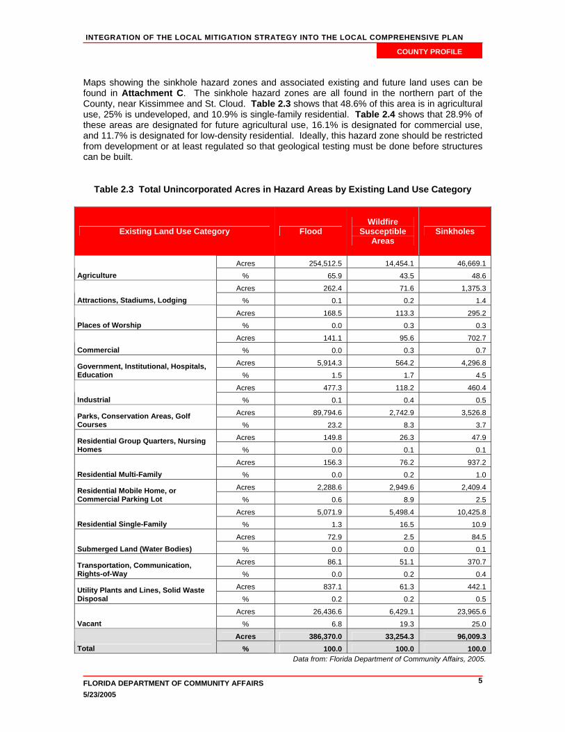
Maps showing the sinkhole hazard zones and associated existing and future land uses can be found in Attachment C. The sinkhole hazard zones are all found in the northern part of the County, near Kissimmee and St. Cloud. Table 2.3 shows that 48.6% of this area is in agricultural use, 25% is undeveloped, and 10.9% is single-family residential. Table 2.4 shows that 28.9% of these areas are designated for future agricultural use, 16.1% is designated for commercial use, and 11.7% is designated for low-density residential. Ideally, this hazard zone should be restricted from development or at least regulated so that geological testing must be done before structures can be built.
Table 2.3 Total Unincorporated Acres in Hazard Areas by Existing Land Use Category
Existing Land Use Category Flood Wildfire
Susceptible Areas
Sinkholes
Acres 254,512.5 14,454.1 46,669.1 Agriculture % 65.9 43.5 48.6
Acres 262.4 71.6 1,375.3 Attractions, Stadiums, Lodging % 0.1 0.2 1.4
Acres 168.5 113.3 295.2 Places of Worship % 0.0 0.3 0.3
Acres 141.1 95.6 702.7 Commercial % 0.0 0.3 0.7
Acres 5,914.3 564.2 4,296.8 Government, Institutional, Hospitals, Education % 1.5 1.7 4.5
Acres 477.3 118.2 460.4 Industrial % 0.1 0.4 0.5
Acres 89,794.6 2,742.9 3,526.8 Parks, Conservation Areas, Golf Courses % 23.2 8.3 3.7
Acres 149.8 26.3 47.9 Residential Group Quarters, Nursing Homes % 0.0 0.1 0.1
Acres 156.3 76.2 937.2 Residential Multi-Family % 0.0 0.2 1.0
Acres 2,288.6 2,949.6 2,409.4 Residential Mobile Home, or Commercial Parking Lot % 0.6 8.9 2.5
Acres 5,071.9 5,498.4 10,425.8 Residential Single-Family % 1.3 16.5 10.9
Acres 72.9 2.5 84.5 Submerged Land (Water Bodies) % 0.0 0.0 0.1
Acres 86.1 51.1 370.7 Transportation, Communication, Rights-of-Way % 0.0 0.2 0.4
Acres 837.1 61.3 442.1 Utility Plants and Lines, Solid Waste Disposal % 0.2 0.2 0.5
Acres 26,436.6 6,429.1 23,965.6 Vacant % 6.8 19.3 25.0
Acres 386,370.0 33,254.3 96,009.3 Total % 100.0 100.0 100.0
Data from: Florida Department of Community Affairs, 2005.

INTEGRATION OF THE LOCAL MITIGATION STRATEGY INTO THE LOCAL COMPREHENSIVE PLAN
FLORIDA DEPARTMENT OF COMMUNITY AFFAIRS 5/23/2005
6
COUNTY PROFILE
Table 2.4 Total and Undeveloped Acres in Hazard Areas by Future Land Use Category
for the Unincorporated County
Flood Wildfire Susceptible Areas Sinkhole
Future Land Use Category Total Undev. Total Undev. Total Undev.
Acres 310,341 17,419 17,303 2,190 45,149 6,918 Agricultural % 80.3% 65.9% 52.0% 34.1% 47.0% 28.9%
Acres 2,270 873 1,600 763 8,960 3,854 Commercial % 0.6% 3.3% 4.8% 11.9% 9.3% 16.1%
Acres 52,644 3,015 1,224 88 3,407 1,773 Conservation % 13.6% 11.4% 3.7% 1.4% 3.5% 7.4%
Acres 4 0 212 136 3,540 1,731 Destination New Town % 0.0% 0.0% 0.6% 2.1% 3.7% 7.2%
Acres 47 5 27 13 0 0 Dual Use/HDR and Commercial % 0.0% 0.0% 0.1% 0.2% 0.0% 0.0%
Acres 8 0 0 0 0 0 Dual Use/Institutional and Commercial % 0.0% 0.0% 0.0% 0.0% 0.0% 0.0%
Acres 104 64 91 44 167 75 HDR % 0.0% 0.2% 0.3% 0.7% 0.2% 0.3%
Acres 0 0 0 0 5,609 1,249 Incorporated % 0.0% 0.0% 0.0% 0.0% 5.8% 5.2%
Acres 666 114 321 105 80 30 Industrial % 0.2% 0.4% 1.0% 1.6% 0.1% 0.1%
Acres 805 113 210 18 1,047 25 Institutional % 0.2% 0.4% 0.6% 0.3% 1.1% 0.1%
Acres 394 6 3 0 167 16 Lake % 0.1% 0.0% 0.0% 0.0% 0.2% 0.1%
Acres 8,438 1,737 3,971 1,143 14,319 2,802 Low Density Residential % 2.2% 6.6% 11.9% 17.8% 14.9% 11.7%
Acres 0 0 2 0 5 0 Low Density Residential with MHO % 0.0% 0.0% 0.0% 0.0% 0.0% 0.0%
Acres 1,195 185 319 92 976 288 Medium Density Residential % 0.3% 0.7% 1.0% 1.4% 1.0% 1.2%
Acres 93 52 14 0 5,216 3,737 Reedy Creek Improvement District % 0.0% 0.2% 0.0% 0.0% 5.4% 15.6%
Acres 0 0 1 0 0 0 Right-of-Way % 0.0% 0.0% 0.0% 0.0% 0.0% 0.0%
Acres 303 87 741 118 926 155 Rural Enclave % 0.1% 0.3% 2.2% 1.8% 1.0% 0.6%
Acres 9,059 2,766 7,215 1,717 6,440 1,311 Suburban % 2.3% 10.5% 21.7% 26.7% 6.7% 5.5%
Acres 386,370 26,437 33,254 6,429 96,009 23,966 Total % 100.0% 100.0% 100.0% 100.0% 100.0% 100.0%
Data from: Florida Department of Community Affairs, 2005. HDR = High Density Residential. MHO = Manufactured Housing Overlay.

INTEGRATION OF THE LOCAL MITIGATION STRATEGY INTO THE LOCAL COMPREHENSIVE PLAN
FLORIDA DEPARTMENT OF COMMUNITY AFFAIRS 5/23/2005
7
COUNTY PROFILE
Table 2.5 presents the existing land uses for the acres in Osceola County that are incorporated within one of the two municipalities. For flood hazard areas, 30.7% is current vacant. A total of 41.3% of the wildfire risk areas that are within Kissimmee or St. Cloud are used for government or institutional uses, and 21.1% is still undeveloped. The largest amount of acres at risk in the cities is subject to sinkholes, and 32.4% of the sinkhole zones within the incorporated areas have single-family homes on them.
Table 2.5 Total Incorporated Acres in Hazard Areas by Existing Land Use Category
Existing Land Use Category Flood Wildfire
Susceptible Areas
Sinkholes
Acres 429.1 76.9 601.7
Agriculture % 15.4 5.5 11.5
Acres 6.5 0.9 4.0
Attractions, Stadiums, Lodging % 0.2 0.1 0.1
Acres 28.5 12.5 99.7
Places of Worship % 1.0 0.9 1.9
Acres 107.0 32.1 198.0
Commercial % 3.8 2.3 3.8
Acres 385.7 573.6 418.0 Government, Institutional, Hospitals, Education % 13.8 41.3 8.0
Acres 19.6 10.3 47.5
Industrial % 0.7 0.7 0.9
Acres 245.9 74.7 511.4 Parks, Conservation Areas, Golf Courses % 8.8 5.4 9.8
Acres 16.5 1.3 40.4 Residential Group Quarters, Nursing Homes % 0.6 0.1 0.8
Acres 149.1 32.6 172.6
Residential Multi-Family % 5.4 2.3 3.3
Acres 22.3 23.6 234.3 Residential Mobile Home, or Commercial Parking Lot % 0.8 1.7 4.5
Acres 427.1 247.9 1,694.1
Residential Single-Family % 15.3 17.8 32.4
Acres 0.2 2.2 5.6 Transportation, Communication, Rights-of-Way % 0.0 0.2 0.1
Acres 94.5 8.7 120.2 Utility Plants and Lines, Solid Waste Disposal % 3.4 0.6 2.3
Acres 854.9 293.4 1,075.4
Vacant % 30.7 21.1 20.6
Acres 2,787.1 1,390.7 5,222.6
Total % 100.0 100.0 100.0
Data from: Florida Department of Community Affairs, 2005.

INTEGRATION OF THE LOCAL MITIGATION STRATEGY INTO THE LOCAL COMPREHENSIVE PLAN
FLORIDA DEPARTMENT OF COMMUNITY AFFAIRS 5/23/2005
8
COUNTY PROFILE
3. Existing Mitigation Measures Local Mitigation Strategy Osceola County’s LMS (approved 2/1/05) includes the following goals and objectives: 1. To establish local government capabilities for developing, implementing and maintaining effective mitigation programs by:
Making data and information needed for defining hazards, risk areas and vulnerabilities readily available
Helping emergency services organizations develop preplanning capability to promptly initiate emergency response operations
Supporting effective use of data and information related to hazard mitigation planning and program development
Measuring and documenting the effectiveness of hazard mitigation initiatives implemented in the community
Deriving and utilizing mitigation 'lessons learned" from each significant disaster event occurring in or near the community
Making community mitigation planning and programming assistance available to the community
2. To build a disaster resistant community by the year 2020 with all sectors of the community working together by:
Advocating for resources to establish and implement a business continuity and recovery program in the community for key community organizations
Establishing interagency agreements for local agencies and organizations, where possible, for the development and implementation of mitigation-related projects and programs
Having governing bodies endorse and implement the local hazard mitigation plan and support community mitigation programming
Establishing outreach programs, where possible, to gain participation in mitigation programs from key business, industry, institutions and community groups
Periodically updating the community regarding local efforts in mitigation planning and programming
3. To maximize capabilities for initiating and sustaining emergency response operations during and after a disaster by:
Establishing policies concerning the relocation, retrofitting or modification of evacuation routes
Determining evacuation shelter priorities for the funding of shelter retrofit or relocation needed to ensure their operability during and after disaster events
Retrofitting or relocating local emergency services facilities to withstand the structural impacts of disasters, as funding becomes available
Providing response capabilities necessary to protect visitors, special needs individuals, and the homeless from a disaster's health and safety impacts as resources permit
Retrofitting or relocating shelters or structures for vehicles and equipment needed for emergency services operations to withstand the impacts of disasters as funds become available
Retrofitting or relocating utility and communications systems supporting emergency services operations to withstand the impacts of disasters as funds become available
Prioritizing routes to and from key critical facilities and evacuation routes for accessibility

INTEGRATION OF THE LOCAL MITIGATION STRATEGY INTO THE LOCAL COMPREHENSIVE PLAN
FLORIDA DEPARTMENT OF COMMUNITY AFFAIRS 5/23/2005
9
COUNTY PROFILE
4. To minimize disruption to the continuity of local government operations by: Retrofitting or relocating buildings and other facilities used for the routine operations of
government, where possible, to withstand the impacts of disasters Preparing community redevelopment plans to guide decision-making and resource
allocation by local government in the aftermath of a disaster Working to protect important local government records and documents from the impacts
of disasters Updating plans and identifying resources to facilitate reestablishing local government
operations after a disaster Obtaining redundant equipment, facilities, and/or supplies, as needed funding becomes
available, to facilitate reestablishing local government operations after a disaster 5. To minimize threats of disasters to the health, safety and welfare of the community's residents and visitors by:
Establishing systems for notifying the public at risk and providing emergency instruction during disasters
Supporting effective structural measures to protect residential areas from the physical impacts of disasters
Seeking to reduce the vulnerability of facilities in the community posing an extra health or safety risk when damaged or disrupted by the impact of a disaster
Encouraging the retrofit or relocation of public and private medical and health care facilities in the community to withstand the impact of disasters
Removing or relocating residential structures from defined hazard areas where feasible Encouraging the retrofit of residential structures by their owners to withstand the physical impacts of disasters
Reducing the vulnerability of structures, facilities and systems serving visitors to the community in order to meet their immediate health and safety needs
Providing resources, equipment and supplies to meet community health and safety needs after a disaster
6. To support effective hazard mitigation programming through establishment and implementation of applicable local government policies and regulations by:
Identifying local government facilities that could be enhanced by mitigation techniques to minimize physical or operational vulnerability to disasters
Reviewing and where appropriate, revising land use policies, plans and regulations in order to discourage or prohibit inappropriate location of structures or infrastructure components in areas of higher risk
Ensuring that hazard mitigation needs and programs are given appropriate emphasis in resource allocation and decision-making
Establishing and enforcing building and land development codes that are effective in addressing the hazards threatening the community
Avoiding high hazard natural areas for new or continuing development Participating in the National Flood Insurance Program (NFIP) and the associated
Community Rating System (CRS) Locating new local government facilities outside of identified high hazard areas and/or
designing them in a manner that minimizes their vulnerability to the impacts of such hazards
Encouraging the use of appropriate hazard mitigation techniques in the reconstruction and rehabilitation of structures and utilities in the community
Promoting private property maintenance that is consistent with minimizing vulnerabilities to disaster

INTEGRATION OF THE LOCAL MITIGATION STRATEGY INTO THE LOCAL COMPREHENSIVE PLAN
FLORIDA DEPARTMENT OF COMMUNITY AFFAIRS 5/23/2005
10
COUNTY PROFILE
7. To minimize the vulnerability of homes, institutions and places of employment to the effects of disaster by:
Identifying funding and providing economic incentive programs for the general public, businesses and industry to implement structural and non-structural mitigation measures
Supporting key employers in the community in the implementation of important mitigation measures for their facilities and systems
Assisting with the removal, relocation or retrofitting of vulnerable structures and utilities in hazard areas including schools, libraries, museums, and other institutions important to the daily lives of the community
8. To minimize the threat to the economic vitality of the community from a disaster by:
Strengthening where feasible components of the infrastructure needed by the community's businesses and industries from the impact of disaster
Developing emergency response and disaster recovery plans that consider the needs of key employers in the community
Encouraging community businesses and industries to make their facilities and operations more disaster resistant
Helping to establish programs, facilities and resources to support the resumption of business activities by local businesses and industry impacted by disasters
Educating the public regarding the condition and functioning of the community in the aftermath of a disaster
9. To minimize disruption to the community's infrastructure from a disaster by:
Encouraging hazard mitigation programming by private sector organizations owning or operating key community utilities including major energy sources, and telecommunications
Supporting routine maintenance of the community's infrastructure to minimize the potential for system failure
Strengthening transportation and utility services in the community to reduce failures 10. To promote community awareness and education by:
Encouraging interested individuals to participate in hazard mitigation planning and training activities.
Providing public education, especially to those living or working in defined hazard areas, about their vulnerability to disasters and effective mitigation techniques
Offering training to managers of public facilities about hazard mitigation techniques and the components of the community's mitigation plan
Providing technical training in mitigation planning and programming to appropriate local government employees
Encouraging information sharing about appropriate hazard mitigation techniques among owners and operators of businesses and industries in the community
Comprehensive Emergency Management Plan The Osceola County Comprehensive Emergency Management Plan (CEMP) was not available for review at the time this profile was drafted. The final version of this document will contain a review of the Mitigation Annex of the CEMP. Post-Disaster Redevelopment Plan A Post-Disaster Redevelopment Plan (PDRP) for Osceola County was not available for review at the time this profile was drafted. If Osceola County has a current PDRP, this will be obtained and reviewed for the final version of this document.

INTEGRATION OF THE LOCAL MITIGATION STRATEGY INTO THE LOCAL COMPREHENSIVE PLAN
FLORIDA DEPARTMENT OF COMMUNITY AFFAIRS 5/23/2005
11
COUNTY PROFILE
National Flood Insurance Program/Community Rating System No information could be found regarding participation in the National Flood Insurance Program’s Community Rating System by Osceola County or any of its municipalities. 4. Comprehensive Plan Review Osceola County’s Comprehensive Plan (adopted in 2004) was reviewed in order to see what the County has already done to integrate their LMS policies, and hazard mitigation in general, into their planning process. A list of the goals, objectives, and policies currently in the plan that contribute to hazard mitigation is found in Attachment D. The following is a summary of how well the plan addressed the three hazards of this analysis. Osceola’s Comprehensive Plan has several policies referring to general hazard mitigation. The Plan refers to the County’s LMS and CEMP, saying that the LMS should be updated on an annual basis and that the LMS should be considered when reviewing land use changes. Another policy requires the County to analyze the distribution of future land uses in order to reduce disaster impacts (Policy 1.13.1), which corresponds with objectives under LMS Goals 5 and 6. There also is a policy to promote public awareness of natural disasters (Policy 2.1.4), which corresponds to Goal 10 in the LMS. There are many policies throughout the elements that refer to evacuation and shelter needs corresponding to the objectives under LMS Goal 3. The evacuation policies require intergovernmental coordination in developing evacuation plans and in maintaining evacuation routes. Policies dealing with sheltering include providing an adequate amount, which Osceola has done for the time being, securing grants to harden schools, and coordinating with the School Board on retrofitting schools in areas with a shelter deficit. Flooding was addressed in the Comprehensive Plan in several policies, as well. There were a few vague policies referring to conserving and limiting development in natural areas such as wetlands, floodplains, and water management areas. A new future land use designation also limits development in those areas to wetland preservation, water management, and passive recreation. Another more defined policy related to flooding prohibits the location of public schools in a velocity flood zone. There also is a goal to provide a stormwater management system and a policy to prioritize stormwater projects based on frequency and degree of flooding. Wildfire was addressed in the Comprehensive Plan only through response and water supply issues. A policy refers to the requirement for residential development that water pressure is adequate for fire fighting. A couple of other policies refer to intergovernmental coordination in mapping firefighting water lines and hydrants. No policies were found during this review that directly related to sinkhole hazards. There were however, two policies that referred to protecting the aquifer, which could decrease the probability of sinkholes since they sometimes can occur from water level changes in the aquifer in karst areas that are already susceptible to sinkhole activity.

INTEGRATION OF THE LOCAL MITIGATION STRATEGY INTO THE LOCAL COMPREHENSIVE PLAN
FLORIDA DEPARTMENT OF COMMUNITY AFFAIRS 5/23/2005
12
COUNTY PROFILE
5. Recommendations For the LMS to be effective in the decision-making process of growth management, its objectives and policies must be integrated into the Comprehensive Plan. The Plan is the legal basis for all local land use decisions made. If hazard mitigation is to be accomplished beyond the occasional drainage project, these hazards must be addressed in comprehensive planning, where development can be limited or regulated in high-risk hazard areas, just as sensitive environments are routinely protected through growth management policies. Mitigation of hazards is considerably easier and less expensive if done when raw land is being converted into development. Retrofitting structure and public facilities after they have been built is significantly more expensive. However, if older neighborhoods or communities are scheduled to be revitalized or redeveloped, hazard mitigation should be an aspect considered and integrated into the project prior to development approval. Osceola County has begun this process of integrating hazard mitigation throughout its Plan’s Elements. The prior section summarized how the major hazards for the County have been addressed for the most part. There is, however, still a disconnect between the LMS objectives and initiatives and the policies in the Comprehensive Plan. By tightening the connection between these documents, the County will find it easier to implement hazard mitigation, and there will be higher awareness of these issues within more departments of the County government. NOTE: The recommendations set out in this section are only suggestions. Through the workshop process and contact with the local governments, the goal of this project is to end up with specific recommendations tailored and acceptable to each county. While the Profile addresses flooding, wildfire, and sinkholes, during the update of the local Comprehensive Plan the County should consider other hazards if appropriate, such as tornadoes and soil subsidence. Comprehensive Plan The LMS has several objectives that relate to identifying hazard areas and reviewing the effectiveness of mitigation measures. This should definitely be a first step in planning for hazards, and yet there were no Comprehensive Plan policies found that highlight the need to identify these hazard zones. It is recommended that the County work to include data and analysis in their Plan that identify geographic areas, such as the analysis included in this profile. This sort of information can lead to planning policies such as overlay zones that increase building code requirements or require impact fees for only those areas that are at risk from the hazard. By having a few policies that define the high-risk hazard zones and require that they be updated and maintained on a regular basis, it will make all mitigation policies more easily implemented and their effectiveness will be easier to measure. Another issue that was absent from the Comprehensive Plan but that is an objective of the LMS is mitigation of public facilities to withstand disasters. The LMS has several objectives that suggest that public facilities, and even private facilities vital to the community such as hospitals, should be relocated out of hazard areas or retrofitted to minimize damage. It is highly recommended that a similar policy be added to the Comprehensive Plan as well as language that restricts public investment in high-risk hazard areas. For instance, a policy could easily be added that restricts infrastructure or public buildings from being built in the floodplain. This would deter private development in flood zones as well, if they could not get infrastructure extended to the property. The LMS also has an objective encouraging the preparation of a post-disaster redevelopment plan (PDRP) and an objective for participating in the NFIP Community Rating System (CRS). The State encourages all counties to develop a PDRP. This can be a stand-alone document or it can be incorporated into the Comprehensive Plan. This would be a valuable tool for the County to have. The Comprehensive Plan also should refer to the County’s intent to continue to

INTEGRATION OF THE LOCAL MITIGATION STRATEGY INTO THE LOCAL COMPREHENSIVE PLAN
FLORIDA DEPARTMENT OF COMMUNITY AFFAIRS 5/23/2005
13
COUNTY PROFILE
participate in the CRS program. This is an important piece of any flood mitigation strategy, and including it as a policy may help in ensuring funding for the program in the future. Osceola’s LMS also refers to supporting the business community and especially key employers in becoming more disaster resistant in several objectives. This could be reflected in the Comprehensive Plan as well. The County could encourage business continuity planning and could provide information to interested businesses. They also could assist businesses through information or incentives in implementing mitigation measures to their facilities. There are also several issues concerning hazard mitigation that are not found in either the LMS or the Comprehensive Plan that should be in these documents. According to the data found in Table 2.1 of this document, wildfire puts 63.6% of the population at risk and yet is addressed in the Plan only through the need to provide water for firefighting. While it is important to ensure adequate water supplies for response, wildfires are best mitigated by preventing their ability to spread to populated areas. This can be done in a number of ways, the best of which is through land use regulations that limit residential development in the wildland interface or intermix zone. Development could be limited near large natural areas that are at high risk for wildfire or by ensuring adequate buffer areas between natural areas and development so that prescribed burns may be used as a routine maintenance measure in the natural area. Requiring firewise site design, building materials, and landscaping in developments within risk zones also will help to protect property. Requirements for multiple entrances or exits to a subdivision in a risk area could help save lives in the event a wildfire threatens the neighborhood by allowing a quicker evacuation. Almost a third of the County is at risk from sinkholes, and there is no mention of this hazard in the LMS or Comprehensive Plan. A policy could be added prohibiting development in a risk zone without first investigating the stability of the soils. Policies directed at preservation of the aquifer could also mention the importance this plays in decreasing the probability of human-induced sinkholes. Overall, some of the policies that are included in the Comprehensive Plan related to hazard mitigation could be strengthened so that they are more directly associated with defined hazards and easier to implement. There are many other policies that are considered best management practices for hazard mitigation that could be considered by the County as they update their Comprehensive Plan. The final draft of this profile will include more of these options. Local Mitigation Strategy The LMS could also be enhanced to include some of the items that the Comprehensive Plan already has or that are recommended for inclusion. For instance, the identification of hazard zones with existing and future land uses overlain could be included in both plans. Also, the objectives in the LMS are broad and could include more detailed policies related to specific hazard types. Using the existing objectives, more specific policies perhaps could be included under each objective referring to how they could be implemented in relation to a certain hazard. Overall, the LMS could be enhanced and further connected with the County Comprehensive Plan. 6. Sources
Florida Department of Community Affairs. 2004. Statewide Emergency Shelter Plan.
Tallahassee, FL. Florida Department of Community Affairs. 2005a. Mapping for Emergency Management,
Parallel Hazard Information System. Tallahassee, FL. http://lmsmaps.methaz.org/lmsmaps/index.html.

INTEGRATION OF THE LOCAL MITIGATION STRATEGY INTO THE LOCAL COMPREHENSIVE PLAN
FLORIDA DEPARTMENT OF COMMUNITY AFFAIRS 5/23/2005
14
COUNTY PROFILE
Florida Department of Community Affairs. 2005b. Protecting Florida’s Communities: Land Use Planning Strategies and Best Development Practices for Minimizing Vulnerability to Flooding and Coastal Storms. Tallahassee, FL.
Osceola County. 2004. Osceola County Comprehensive Plan. Osceola County. 2005. Local Mitigation Strategy. University of Florida, Bureau of Economic and Business Research. 2004. Florida Statistical
Abstract. Gainesville, FL. U.S. Census Bureau. 2000. State and County Quickfacts. Retrieved in 2005 from
http://quickfacts.census.gov/qfd/index.html.

INTEGRATION OF THE LOCAL MITIGATION STRATEGY INTO THE LOCAL COMPREHENSIVE PLAN
FLORIDA DEPARTMENT OF COMMUNITY AFFAIRS 5/23/2005
A-1
COUNTY PROFILE
Attachment A
Maps of the Existing and Future Land Uses within the 100-year Floodplain

INTEGRATION OF THE LOCAL MITIGATION STRATEGY INTO THE LOCAL COMPREHENSIVE PLAN
FLORIDA DEPARTMENT OF COMMUNITY AFFAIRS 5/23/2005
B-1
COUNTY PROFILE
Attachment B
Maps of the Existing and Future Land Uses within the High-Risk Wildfire Zone

INTEGRATION OF THE LOCAL MITIGATION STRATEGY INTO THE LOCAL COMPREHENSIVE PLAN
FLORIDA DEPARTMENT OF COMMUNITY AFFAIRS 5/23/2005
C-1
COUNTY PROFILE
Attachment C
Maps of the Existing and Future Land Uses within the High-Risk Sinkhole Zones

INTEGRATION OF THE LOCAL MITIGATION STRATEGY INTO THE LOCAL COMPREHENSIVE PLAN
FLORIDA DEPARTMENT OF COMMUNITY AFFAIRS D-1 5/23/2005
COUNTY PROFILE
Attachment D
Osceola County Comprehensive Plan Excerpts Related to Hazard Mitigation Future Land Use Element Policy 1.3.42: Pursuant to a natural resource inventory by December 2004, Osceola County shall adopt as part of the Land Development Code land use restrictions and incentives as measures to protect potable water well fields, environmentally sensitive lands, areas characterized by a fire ecology, aquifer recharge areas, and all other identified natural resources, resource areas, and raw materials determined to be critical to the overall health, safety, and welfare of the residents of the County from incompatible land uses and activities. Policy 1.3.43: Osceola County shall require that all developments with a significant impact upon natural resources, including but not limited to developments involving mining, natural resource extraction, wetlands removal, or environmentally sensitive habitat destruction, prepare an environmental impact statement and mitigation plan. This environmental impact statement shall detail the long-term potential land use impacts upon the natural resource base of the County and demonstrate how those land use impacts will be alleviated. This policy shall not authorize the County to regulate impacts of the consumptive use of water as provided in Chapter 373, F.S. However, such applicant will still be required to address those other impacts of the proposed activity that involve construction, installation, erection, acquisition, operation, maintenance, improvement, extension, connection, enlargement, or reconstruction of any project infrastructure. Policy 1.4.2: Osceola County adopts a Conservation/Open Space Future Land Use category for properties within the Poinciana Township PD. Uses in this category will be limited to upland and wetland preservation, water management areas (primarily non-structural) and passive recreation. In those areas where the boundaries are based upon wetlands, jurisdictional determinations by the appropriate State or Federal agency will supersede the general delineations of the Future Land Use Map series. This land use category is compatible with land uses already existing in the Planned Development and provides consistency with BLIVR 783-002. Policy 1.7.4: Osceola County shall require the following location criteria for public schools:
3. The proposed location shall not be located within a velocity flood zone/flood way.
Objective 1.13: Hazard Mitigation. Osceola County shall annually review any interagency hazard mitigation reports that have been issued at the Federal or State level due to a Presidential Disaster Declaration. Policy 1.13.1: Based on the review of the interagency hazard mitigation reports, Osceola County shall analyze the distribution of Future Land Use in conjunction with the recommendations of Federal or State agencies in order to reduce the potential for future flooding, reduction of property losses and the promotion of public welfare. Policy 1.13.2: The County shall consider the Local Mitigation Strategy (LMS) when reviewing requests for land use changes to ensure that the requested land use designation do not conflict with the LMS.

INTEGRATION OF THE LOCAL MITIGATION STRATEGY INTO THE LOCAL COMPREHENSIVE PLAN
FLORIDA DEPARTMENT OF COMMUNITY AFFAIRS D-2 5/23/2005
COUNTY PROFILE
Parks and Recreational Facilities Element Policy 1.1.14: Community and regional parks shall develop at a minimum Pervious Surface Ratio of 0.50. Policy 1.1.21: The County shall encourage developments to incorporate parks or recreational facilities adjacent to wetlands and water management areas. Public Educational Facilities Element Objective 2.3: Provision of Emergency Shelters. The County shall assure the adequate provision of emergency shelters. Policy 2.3.1: The Osceola County Office of Emergency Management and the School Board of Osceola County Facility Construction Office shall establish a schedule and attempt to secure grant funding as available for selected and/or appropriate educational facilities for activities such as but not limited to shuttering for the protection of openings, emergency power transfer switches, emergency power generators, retrofitting of structures, including walls and roofs to meet hurricane force winds. Policy 2.3.2: When grant funding is available and awarded, the Osceola County Office of Emergency Management shall coordinate with the appropriate School Board staff to ensure the retrofit of one or more public educational facilities each year to meet host/impact requirements. Priority shall be given to those areas of Osceola County that have been identified by the Office of Emergency Management as having a shelter deficit. Public Safety Element Policy 1.1.2: For all new residential development, and any new phases of existing residential development, the County will require certification from the water supplier as to their capacity to deliver the required water flows for firefighting, as determined by the Insurance Services Office (ISO) flow chart. Objective 1.2: Coordinated Mapping Project. The County should enter into an interlocal agreement with the Tohopekaliga Water Authority and the City of St. Cloud, and all other applicable agencies, to develop and maintain database of the existing and planned potable water, sanitary sewer, reuse water, firefighting water lines, and fire hydrants. Policy 1.2.1: All involved agencies should form a project team to create and manage the water line database. Policy 1.2.6: The County will coordinate with the adjacent utility provider to develop and maintain a fire hydrant mapping program for use by fire and rescue services. GOAL 2: DISASTER PREPAREDNESS, MITIGATION, AND RECOVERY. The Osceola County Office of Emergency Management shall provide coordination of the preparedness, response, recovery, and mitigation responses to natural and man-made disasters that may affect the residents and visitors of Osceola County.

INTEGRATION OF THE LOCAL MITIGATION STRATEGY INTO THE LOCAL COMPREHENSIVE PLAN
FLORIDA DEPARTMENT OF COMMUNITY AFFAIRS D-3 5/23/2005
COUNTY PROFILE
Objective 2.1: Emergency Management. The County shall continue to coordinate with surrounding local governments and appropriate state agencies to develop local and regional evacuation management plans. Policy 2.1.1: The County shall coordinate with the Florida Department of Transportation to identify key evacuation routes that are vulnerable to flooding erosion and critical points of congestion during an evacuation. Policy 2.1.2: The County shall coordinate with the appropriate agencies to develop recommended roadway improvements for those areas along the proposed evacuation routes identified to have deficiencies. Priority shall be given to those evacuation routes servicing the highest number of people. Policy 2.1.3: The County shall use the Osceola County Comprehensive Emergency Management Plan (CEMP) to guide its disaster preparedness and recovery operations. The County shall use this document to guide coordination efforts, including working with the cities of the County, the Osceola County School District, the applicable State agencies. Policy 2.1.4: The County shall improve its disaster preparedness functions by increasing public awareness of natural diasters. Objective 2.2: Local Mitigation Strategy (LMS). The County shall meet on a regular basis with local entities to introduce new projects into the LMS, prioritize hazard mitigation projects, and update the LMS. Policy 2.2.2: The County shall coordinate with the Florida Department of Community Affairs Division of Emergency Management and the Federal Emergency Management Agency to pursue funding opportunities and to manage disaster recovery operations. Policy 2.2.4: To ensure that the County maintains its eligibility for hazard mitigation and disaster preparedness grants, the County shall review and update the LMS on an annual basis. Policy 2.2.5: The County shall prioritize the funding and planning of Local Mitigation Strategy projects within the 100-year floodplain. Stormwater Management Element GOAL 1: PROVISION OF A COMPREHENSIVE STORMWATER MANAGEMENT SYSTEM. Osceola County shall endeavor to provide, as resources and opportunities are available, a comprehensive stormwater management system that protects persons and property from flooding, prevents negative impacts to the natural groundwater aquifer, and safeguards surface waters against the degradation of water quality, thereby promoting the health, safety, and welfare of Osceola County residents. Objective 1.1: Flood Control. The County shall evaluate floodplain permitting to protect the function of floodplains. Policy 1.1.1: The County shall evaluate development within the 100-year floodplain so as not to adversely affect the capacity of the floodplain to store water. Mitigation through compensating storage may be permissible.

INTEGRATION OF THE LOCAL MITIGATION STRATEGY INTO THE LOCAL COMPREHENSIVE PLAN
FLORIDA DEPARTMENT OF COMMUNITY AFFAIRS D-4 5/23/2005
COUNTY PROFILE
Policy 1.1.3: Stormwater management improvement projects shall be prioritized within the urbanizing area based upon the frequency of flooding, severity of flooding, water quality problems, existing land uses, Future Land Use Map categories, and basin studies.