ord~r. - city of englewood, colorado | home
TRANSCRIPT

1. . Call to Ord~r.
2. Invocation.
3. Pledge of Allegiance.
4. Roll Call.
Agenda for the
Regular Meeting of the
Englewood City Council
Monday, November 19, 2012
7:30pm
Englewood Civic Center- Council Chambers 1 000 Englewood Parkway
Englewood, CO 8011 0
5. Consideration of Minutes of Previous Session.
a. Minutes from the Regular City Council Meeting of November 5, 20 12.
6. Recognition of Scheduled Public Comment. (This is an opportunity for the public to address City Council. Council may ask questions for clarification, but there will not be any dialogue. Please limit your presentation to five minutes.)
a. Recognition of 2013 Englewood Calendar Artists.
i. Kyra Roquemore, a gth Grader at Colorado's Finest Alternative High School
ii. Diego Rios-Pineda, a 4th Grader at Clayton Elementary School
iii. Jamie Valdez, an 11th Grader at Colorado's Finest Alternative High School
iv. . lrae Mautoabasi, a Kindergartner at Clayton Elementary School
v. Tess Bray, a gth Grader at East High School
vi. Cesar Aguilar-Morales, a 4th Grader at Clayton Elementary School

Englewood City Council Agenda · November 19, 2012
Page 2
vii. Isaac Medrano, a 4th Grader at Clayton Elementary School
viii. Alexander LaCount, a 4ti, Grader at Cl~yton Elementary School
ix. Michaela Martinez, a 12th Grader at Englewood High School
x. joseline Ortiz, a 1st Grader at Englewood High School
xi. Natalie Hiibschman, a 12th Grader at Englewood High School
xii. · Kaylie Carpenter, a 61h Grader at Clayton Elementary School
xiii. Shawn Michaelis, an 11th Grader at Colorado's Finest Alternative High School
xiv. Lizzy Marcoux, a 151 Grader at All Souls Catholic School
xv. Kaleb Greene, a 3'd Grader at Clayton Elementary School
7. Recognition of Unscheduled Public Comment. (This is an opportunity for the public to address City Council. Council may ask questions for clarification, but there will not be any dialogue. Please limit your presentation to three minutes. Time for unscheduled public comment may be limited to 45 minutes, and if limited, shall be continued to General Discussion.)
Co unci I Response to Public Comment
8. Communications, Proclamations, and Appointments.
a. Letter from Katie Walsh indicating her resignation from the Keep Englewood Beautiful Board.
b. Letter from Brianna Carey indicqting her resignation from the Englewood Cultural Arts. Commission.
9. Consent Agenda Items.
a. Approval of Ordinances on First Reading.
i. Council Bill No. 60 - Recommendation from the Public Works Department to adopt a bill for an ordinance authorizing an Intergovernmental Agreement with the Denver Council Regional Council of Governments for the 2012 Traffic Signal System Equipment Purchase. Staff Source: Rick Kahm, Director of Public Works and ladd Vostry, Traffic Engineer.
b. Approval of Ordinances on Second Reading.

Englewood City .Council Agenda November 19, 2012 Page 3
c. Resolutions and Motions.
i. Recommendation from the Public Works Department to approve a resolution modifying the Permit Fees for the use of the City's Rights of Way. Staff Source: Dave Henderson, Engineering/Capital Projects Administrator.
ii. Recommendation from the Public Works Department to approve a resolution authorizing a concrete utility fee increase. Staff Source: Dave Henderson, Engineering/Capital Projects Administrator.
10. Public Hearing Items.
a. A Public Hearing to gather input on Council Bill No. 58, approving the rezoning of Flood Middle .School from MU-B-1, MU-R-3-B and R-2-B to PUD.
b. A Public Hearing to gather input on Councii.Bill No. 59, approving the Alta Cherry Hills Major Subdivision.
11. Ordinances, Resolutions and Motions
a. Approval of Ordinances on First Reading.
i. Council Bill No 57- Recommendation from the Utilities Department to adopt a bill for an ordinance amending sections of the Englewood Municipal Code pertaining to sewer fees and charges. Staff Sources: Stewart H. Fonda, Director 9f Utilities.
ii. Council Bill No. 61 -Recommendation from the City Manager's Office to adopt a bill for an ordinance amending the Englewood Municipal code pertaining to use of public facilities in the City right of way. Staff Source: Michael Flaherty, Deputy City Manager.
iii. Council Bill No. 62- Recommendation from the Finance Department to adopt a bill for an ordinance modifying the Englewood Municipal Code to comply with the City of Englewood Firefighters Pension Plan Document and Colorado Statutes. Staff Source: Frank Gryglewicz, Director of Finance and Administrative Services.
iv. Council Bill No. 63 - Recommendation from the Englewood Office of Emergency Management to adopt a bill for an ordinance approving the application for and
. acceptance of a 2013 Emergency Management Program Grant. Staff Source: Steve Green, Emergency Management Coordinator.
b; Approval of Ordinances on Secol'ld Reading.
c. Resolutions and Motions.

Englewood City Council Agenda November 1 Q, 2012 Page 4
12. General Discussion.
a. Mayor's Choice.
b. Council Members' Choice.
13. City Manager's Report.
14. City Attorney's Report.
15. Adjournment.

To: Subject:
Audra Kirk; Sue Carlton-Smith RE: resignation
From: Katie Walsh L.~· ·=· =··-~· ~=..........-~ ............ ~~~. Sent: Thursday, November 01, 2012 2:09 PM To: Audra Kirk Subject: resignation
HiAudra
8a
i hope you are doing well. i am writing to let you know that i wish to resign from my position on the board at keb. i feel i cannot dedicate my time anymore since i am heavily involved with school. i feel that my spot could be utilized for someone better able to dedicate their time.
thank you for everything and please let me know if there is anything else i need to do.
Thanks Katie Walsh
1

To: Debby Severa
Subject: RE: Cultural Arts Commission
From: Carey, Brianna L----~-----Sent: Monday, October 29, 2012 12:22 PM To: Debby Severa Subject: Cultural Arts Commission
Hi Debby,
I wanted to let you know that I most likely won't be able to attend many meetings for the Cultural Arts Commission in the next few months due to health problems. At this time I think it may be better to find a member to fill my place who can be more committed. Thank you to the commission and to city council for giving me this wonderful opportunity, I apologize that I cannot continue with it. I hope that in the future I can be apart of it again; the Cultural Arts Commission is definitely a wonderful group of people!
I hope you all the best!
Thank you.
Bri Carey 720-998-2921
1
8b

COUNCIL COMMUNICATION
Date: Agenda Item: Subject
November 19, 2012 9 a i IGA with DRCOG for 2012 Traffic Signal System Equipment Purchase
Initiated By: Staff Source:
Department of Public Works Rick Kahm, Director Ladd Vostry, Traffic Engineer
COUNCIL GOAL AND PREVIOUS COUNCIL ACTION
City Council approved Bills for an Ordinance to enter into an agreement with the Denver Regional Council of Governments (DRCOG) to allow DRCOG to reimburse the City of Englewood for 2004, 2005, 2007, 2008, 2009, and 201 0 miscellaneous traffic signal equipment purchases.
RECOMMENDED ACTION
Staff requests that City Council adopt a Bill for an Ordinance to enter into an Intergovernmental Agreement (IGA) with the DRCOG for the 2012 Traffic Signal System Equipment Purchase program. This IGA will allow DRCOG to reimburse the City of Englewood for the cost of traffic signal system equipment (to be purchased by the City in 2013) in an amount up to $29,000.
BACKGROUND, ANALYSIS, AND ALTERNATIVES IDENTIFIED
The Traffic Engineering Division of Public Works submitted an application to DRCOG to be considered for traffic signal equipment purchases in the 2012 Traffic Signal System Equipment Purchase program. DRCOG, responsible for administering this program, received U.S. Department of Transportation Congestion Mitigation/Air Quality (CM/AQ) funds through the Colorado Department of Transportation (COOT) to carry out traffic signal system improvements and purchases in the Denver region. All applications were reviewed and scored by DRCOG based on previously set criteria consistent with the adopted Traffic Signal System Improvement Program (TSSIP). Englewood has been awarded up to $29,000 towards the purchase of traffic signal equipment, which includes a traffic signal cabinet with ASC/3 controller, uninterruptable power supply (UPS), and Ethernet radios and switches.
The Traffic Signal System Equipment Purchase program covers equipment purchases only, with equipment installation being completed by City forces. These improvements will enhance the functionality and efficiency of the traffic control along the Dartmouth corridor (west of Santa Fe), and at the Oxford and Navajo/Windermere intersection.
FINANCIAL IMPACT
There are no financial obligations for the City other than providing funds up front for the equipment purchases, which are later reimbursed to the City. Adequate funds are available in the Transportation System Upgrade account and will be credited back to this account with the reimbursement of Federal funds by DRCOG.
LIST OF ATTACHMENTS
Bill for an Ordinance Contract (IGA) between DRCOG and City of Englewood
1
ORDINANCE NO. SERIES OF 2012
BY AUTHORITY
COUNCIL BILL NO. 60 INTRODUCED BY COUNCIL MEMBER __________ _
A BILL FOR
AN ORDINANCE APPROVING AN INTERGOVERNMENTAL AGREEMENT (IGA) ENTITLED "CONTRACT BY AND BETWEEN THE DENVER REGIONAL COUNCIL OF GOVERNMENTS (DRCOG) AND THE CITY OF ENGLEWOOD" FOR REIMBURSEMENT TO THE CITY OF ENGLEWOOD, COLORADO FOR THE COSTS OF 2012 TRAFFIC SIGNAL SYSTEM EQUIPMENT PURCHASE.
WHEREAS, the Englewood City Council previously approved Ordinances to enter into agreements with Denver Regional Council of Governments (DR COG) to allow DR COG to reimburse the City of Englewood for 2004, 2005,2007,2008,2009 and 2010, miscellaneous traffic signal equipment purchases; and
WHEREAS, DRCOG received U.S. Department of Transportation Congestion Mitigation/Air Quality (CM/AQ) funds through the Colorado Department of Transportation (CDOT) to carry out traffic signal system improvements and purchases in the Denver metropolitan region; and
WHEREAS, DRCOG desires to contract with the City for the purchase of miscellaneous traffic signal equipment consistent with the Traffic Signal System Equipment Purchase Program; and
WHEREAS, DRCOG is responsible for monitoring and administering this federal program; and
WHEREAS, the passage of this Ordinance authorizes the intergovernmental agreement allowing DRCOG to reimburse the City of Englewood for the cost of traffic signal system equipment, which will be purchased by the City in 2013, in an amount up to $29,000;
NOW, THEREFORE, BE IT ORDAINED BY THE CITY COUNCIL OF THE CITY OF ENGLEWOOD, COLORADO, AS FOLLOWS:
Section 1. The City Council of Englewood, Colorado, hereby authorizes an intergovernmental agreement (IGA) entitled "Contract by and Between the Denver Regional Council of Governments (DRCOG) and the City of Englewood" for reimbursement to the City of Englewood, Colorado for the cost of traffic signal system equipment, which will be purchased by the City in 2013 in an amount up to $29,000, a copy of which is attached hereto as Exhibit 1.

Section 2. The Mayor is hereby authorized to sign and the City Clerk to attest said intergovernmental agreement (IGA) entitled "Contract by and Between the Denver Regional Council of Governments (DR COG) and the City of Englewood" for and on behalf of the City of Englewood.
Introduced, read in full, and passed on first reading on the 19th day of November, 2012.
Published by Title as a Bill for an Ordinance in the City's official newspaper on the 23rd day of November, 2012.
Published as a Bill for an Ordinance on the City's official website beginning on the 21st day of November, 2012 for thirty (30) days.
Randy P. Penn, Mayor ATTEST:
Loucrishia A. Ellis, City Clerk
I, Loucrishia A. Ellis, City Clerk of the City of Englewood, Colorado, hereby certify that the above and foregoing is a true copy of a Bill for an Ordinance, introduced, read in full, and passed on first reading on the 5th day ofNovember, 2012.
Loucrishia A. Ellis
CONTRACT BY AND BETWEEN THE
DENVER REGIONAL COUNCIL OF GOVERNMENTS 1290 Broadway, Suite 700
Denver, Colorado 80203-5606 ("DRCOG")
and
CITY OF ENGLEWOOD 1 000 Englewood Parkway
Englewood, Colorado 80110-2373 ("CONTRACTOR")
for
2012 TRAFFIC SIGNAL SYSTEM EQUIPMENT PURCHASE
Project Number: 543011 Contract Number: EX12016
RECITALS:
A. DRCOG has received U.S. Department of Transportation Congestion Mitigation/Air Quality (CM/AQ) funds through the Colorado Department of Transportation (COOT), to carry out traffic signal system improvements and purchases in the Denver metropolitan region.
B. Authority exists in the law and funds have been budgeted, appropriated, and otherwise made available and a sufficient unencumbered balance thereof remains available for payment.
C. DR COG desires to engage the Contractor for the purchase of miscellaneous traffic signal equipment consistent with the adopted Traffic Signal System Improvement Program further described in this contract and Exhibit A.
D. The Contractor agrees to comply with all applicable provisions of the contract between DRCOG and COOT, which are incorporated herein by reference and made a part of this contract, as if fully set forth, in the monitoring and administration of this contract.
NOW, THEREFORE, it is hereby agreed that:
1. PURCHASE OF THE EQUIPMENT
a. General Requirements. The Contractor shall administer and purchase the equipment that is described in the attached Exhibit A, which is made a part of this contract, in accordance with Title 49, Parts 18 and 19, as appropriate, of the Code of Federal Regulations regarding uniform administrative requirements for state and local governments and other non-profit organizations.
b. Submissions of Proceedings. Contract, and Other Documents. The Contractor shall submit to DRCOG all data, reports, records, contracts, and other documents collected and developed by the Contractor relating to the project as DRCOG may require. The Contractor shall retain intact, for three years following project closeout, all contract documents, financial records, and supporting documents.
E X H I B I
I T
1

c. Award of Contract. This contract is awarded to the Contractor based upon the Contractor's project application, which provides that the Contractor be responsible for all expenses associated with acquiring, installing, operating and maintaining the equipment, excluding the actual purchase cost of the equipment. Contractor agrees that Contractor costs for staff and subcontractors will not be reimbursable as part of this contract.
d. No DRCOG Obligations to Third Parties. DRCOG shall not be subject to any obligations or liabilities to any person not a party to this contract in connection with the performance of this project pursuant to the provisions of this contract without its specific written consent. Neither the concurrence in, or approval of, the award of any contract or subcontract or the solicitation thereof nor any other act performed by DRCOG under this contract constitutes such consent.
2. ACCOUNTING RECORDS
a. Accounts. The Contractor shall establish and maintain as a separate set of accounts, or as an integral part of its current accounting scheme, accounts for the equipment purchases to assure that funds are expended and accounted for in a manner consistent with the requirements of this contract, the contract between DRCOG and COOT and all applicable federal and state laws, and their implementing regulations.
b. Funds Received or Made Available. The Contractor shall appropriately record in the account all reimbursement payments received by it from DRCOG pursuant to this contract.
c. Allowable Costs. Expenditures made by the Contractor shall be reimbursable as . allowable costs to the extent they meet all of the requirements set forth below. Such expenditures must:
1) Be made in conformance with the description, budget, and all other provisions of this contract.
2) Be necessary for the accomplishment of this contract, and reasonable in the amount of goods and services provided.
3) Be actual net costs to the Contractor (i.e., price paid minus any refunds, rebates, or other items of value received by Contractor that have the effect of reducing the cost actually incurred).
4) Be incurred for equipment purchased only as described in Exhibit A, after the date of this contract.
'5) Be treated uniformly and consistently under generally accepted accounting principles.
6) Be in conformance with the standards for allowability of costs set forth in Office of Management and Budget Circulars No. A-122 or A-87, as appropriate, regarding cost principles for nonprofit organizations and state and local governments.
d. Documentation of Costs. Invoices, contracts, and/or vouchers detailing the nature of the charges shall support all equipment purchase costs charged to this contract.
2
e. Checks, Orders, and Vouchers. Any check or order drawn up by the Contractor with respect to any item which is or will be chargeable against this contract will be drawn only in accordance with a properly signed voucher then on file in the office of the Contractor, which will detail the purpose for which said check or order is drawn. All checks, payrolls, invoices, contracts, vouchers, orders, or other accounting documents pertaining in whole or in part to the project shall be clearly identified, readily accessible, and, to the extent feasible, kept separate and apart from all other such documents.
f. Audits and Inspections. At any time during normal business hours and as often as DRCOG, COOT and U.S. Department of Transportation (hereinafter, "USDOT"), and/or the Comptroller General of the United States may deem necessary, there shall be made available to DR COG, COOT, US DOT and/or the Comptroller General, or any of their duly authorized representatives, for examination, all books, documents, papers, and records, whether in electronic, digital, hard-copy or other form, with respect to all matters covered by this contract and the Contractor will permit DRCOG, COOT, US DOT, and/or representatives of the Comptroller General to audit, examine, and make excerpts or transcripts from such records, and to make audits of all contracts, invoices, materials, payrolls, records of personnel, conditions of employment and other data relating to all matters covered by this contract.
3. TIME OF PERFORMANCE
This contract shall commence upon execution and shall expire December 31, 2013.
4. COST OF EQUIPMENT PURCHASES
The cost for equipment purchases in which federal funds are participating shall not exceed Twenty-Nine Thousand Dollars ($29,000.00) as described in the attached Exhibit A.
The Contractor agrees to provide all installation, operation and maintenance of the purchased equipment at its expense.
5. REQUEST FOR PAYMENT BY THE CONTRACTOR
a. Award. DRCOG shall reimburse the Contractor up to Twenty-Nine Thousand Dollars ($29,000.00) for the purchase of traffic signal equipment as described in the attached Exhibit A.
b. Payment. Payment shall be made on the following basis: After receipt of the equipment, the Contractor shall submit the invoice to the DRCOG Accounting Department for reimbursement. DRCOG will incorporate the invoice into its next bill to COOT. Upon receipt by DRCOG of payment from COOT and upon verification by DRCOG that the Contractor has installed the equipment and that the equipment is operating as intended, DR COG will reimburse the Contractor for the amount of allowable costs of the Contractor's invoice. It is the Contractor's sole responsibility to install the equipment and contact DRCOG for field verification prior to receiving reimbursement.
3

6. MANAGEMENT
a. DRCOG Representative. DRCOG has designated Greg MacKinnon as its representative who will coordinate reviews, approvals, and authorizations.
b. Contractor's Representative. The Contractor has designated Ladd Vestry as its representative for this contract who shall be responsible for coordination and liaison with DRCOG on the equipment purchases associated with this contract. If at any time a contractor representative is not assigned for this contract, the Contractor shall immediately notify DRCOG and work shall be suspended until a representative has been assigned who is acceptable to DRCOG.
c. By signing this contract, the Contractor certifies that neither it nor its principals are presently debarred, suspended, proposed for debarment, declared ineligible or voluntarily excluded from participation in this transaction by any Federal department or agency.
7. PERSONNEL
The Contractor represents it will provide and secure the personnel required in installing, maintaining and operating the equipment listed in Exhibit A. All of the services required hereunder will be performed by the Contractor or under its supervision, and all personnel engaged in the work shall be fully qualified and shall be authorized under State and local law to perform such services. Such personnel shall not be employees of or have any contractual relationship with DRCOG. Any subcontracts entered into by the Contractor associated with this Contract shall include a statement that the parties to the subcontract understand that DRCOG is not obligated or liable in any manner to the subcontractor or for the performance by the Contractor of its obligations under the subcontract.
8. TERMINATION
a. Funds not Available. The parties expressly recognize that the Contractor is to be paid, reimbursed or otherwise compensated with federal and/or State funds which are available to DRCOG for the project. In the event that CM/AQ funds are not made available to DRCOG per Recital A, this contract shall terminate immediately. Contractor expressly understands and agrees that all of its rights, demands and claims to compensation arising under this contract are contingent upon availability of such funds toDRCOG.
b. Termination for Mutual Convenience. The parties may, with the concurrence of COOT, terminate this contract if both parties agree that the equipment purchases specified in Exhibit A would not produce beneficial results.
c. Termination of Contract for Cause. If through any cause, excluding force majeure, the Contractor shall fail to fulfill in timely and proper manner its obligations under this contract, or if the Contractor shall violate any of the covenants, agreements, or stipulations of this contract, and has not corrected such breach within ten days of being given notice by DR COG, DR COG shall thereupon have the right to terminate this contract by giving written notice to the Contractor of such termination for cause, which shall be effective upon receipt of the written notice.
4

In that event, DRCOG shall not be required to reimburse the Contractor for any equipment purchases not yet billed to COOT, and Contractor shall be obligated to return any payments previously received under the provisions of this contract. Notwithstanding the above, the Contractor shall not be relieved of liability to DRCOG for any damages sustained by DR COG by virtue of any breach of the contract by the Contractor.
d. Termination for the Convenience of DRCOG. DRCOG may terminate this contract at any time by giving written notice to the Contractor of such termination, which shall be effective upon receipt of the written notice. If the contract is terminated by DRCOG as provided herein, the Contractor shall be entitled to receive compensation for any equipment purchases made prior to the effective date of such termination, subject to field verifications being completed to the satisfaction of DRCOG.
9. EQUAL EMPLOYMENT OPPORTUNITY
During the performance of this contract, the Contractor agrees to comply with all federal and state laws, rule, regulations, and orders regarding equal employment opportunity, including Executive Order 11256, "Equal Employment Opportunity," as amended by Executive Order 11375, "Amending Executive Order 11246 Relating to Equal Employment Opportunity," and as supplemented by regulations at 41 CFR part 60, "Office of Federal Contract Compliance Programs, Equal Employment Opportunity, Department of Labor."
10. DISADVANTAGED BUSINESS ENTERPRISE
a. Policy. DRCOG is committed to and has established a Disadvantaged Business Enterprise (DBE) program in accordance with the regulations of the U.S. Department of Transportation (DOT), 49 CFR Part 26. It is the policy of DRCOG to ensure that DBEs, as defined in Part 26, have an equal opportunity to participate in the performance of contracts and subcontracts receiving DOT funding assistance. Consequently, the DBE requirements of 49 CFR, Part 26 apply to this contract.
b. DBE Obligation. The Contractor and its subcontractors agree to ensure that DBEs as determined by the Office of Certification at the Colorado Department of Regulatory Agencies have the maximum opportunity to participate in the performance of contracts and subcontracts receiving DOT funding assistance provided under this contract. In this regard, the Contractor and subcontractors shall take all necessary and reasonable steps in accordance with this policy to ensure that DBEs have the maximum opportunity to compete for and perform contracts. The Contractor and their subcontractors shall not discriminate on the basis of race, color, national origin, mental or physical handicap or sex in the award and performance of contracts and subcontracts receiving DOT funding assistance.
5

11.1NTEREST OF MEMBERS OF DRCOG AND OTHERS
No officer, member, or employee of DRCOG and no members of its governing body, and no other public official of the governing body of the locality or localities in which the project is situated or being carried out who exercises any functions or responsibilities in the review or approval of the undertaking or carrying out of this project, shall participate in any decision relating to this contract which affects his personal interest or the interest of any corporation, partnership, or association in which he is directly or indirectly interested or have any personal or pecuniary interest, direct of indirect, in this contract or the proceeds thereof.
12. INTEREST OF THE CONTRACTOR
No officer, member, employee or agent of the Contractor or any other person who is authorized to exercise any functions or responsibilities in connection with the negotiating, review or approval of the undertaking or carrying out of any segment of the program contemplated by this contract shall have any financial or other personal interest, direct or indirect, in this contract or any subcontract thereunder, or in any real or personal property acquired therefore. Any person who shall involuntarily acquire any such incompatible or conflicting personal interest shall immediately disclose his/her interest to DRCOG in writing. Thereafter (s)he shall not participate in any action affecting the program under this contract unless DRCOG shall have determined that, in light of the personal interest disclosed, the participation in such action would not be contrary to the public interest.
13.1NDEMNIFICATION
The Contractor is an independent contractor and not an employee ofDRCOG. As an independent contractor, the Contractor is not entitled to workers' compensation benefits except as may be provided by the Contractor nor to unemployment insurance benefits unless unemployment compensation coverage is provided by the Contractor or some other entity. The Contractor is obligated to pay all applicable federal and state income tax on any moneys earned or paid pursuant to this contract relationship. The parties agree that the Contractor is free from the direction and control of DRCOG except such control as may be required by any state or federal statute or regulation, and that DRCOG does not require the Contractor to work exclusively for DRCOG; does not establish a quality standard for the Contractor; does not provide training, or does not provide tools or benefits of performance by the Contractor except through a completion schedule.
To the extent allowable by law, the Contractor shall indemnify, save and hold harmless DRCOG, its officers, employees and agents, against any and all claims, damages, liability and court awards, including all costs, expenses, and attorney fees incurred as a result of any negligent act or omission of the Contractor, or its employees, agents, subcontractors or assignees related to this contract. The Contractor shall include language similar to the foregoing in any subcontract associated with this Contract, stating that. the subcontractor agrees to indemnify, save and hold harmless DRCOG for negligent acts or omissions of the subcontractor, its employees, agents, subcontractors, and assignees.
The Contractor, as a "public entity" within the meaning of the Colorado Governmental Immunity Act, CRS §24-10-101, et seq., as amended (the "GIA''), shall maintain at all times during the term of this contract such liability insurance, by commercial policy or self-insurance,
6

as is necessary to meet its liabilities under the GIA. The Contractor shall show proof of such insurance satisfactory to DRCOG and COOT, if requested by DRCOG or COOT.
14. FEDERAL REQUIREMENTS
The Contractor shall at all times during the execution of this contract strictly adhere to, and comply with, all applicable federal and state laws, and their implementing regulations, as they currently exist and may hereafter be amended, which are incorporated herein by this reference as terms and conditions of this contract. The Contractor shall also require compliance with these statutes and regulations in subcontract agreements associated with this contract.
The Contractor agrees to abide by and follow all applicable federal and state guidelines when expending any funds resulting from this contract. This includes, but is not limited to, the Procurement Standards set forth in Subpart C of OMB Circular A-110 and the applicable provisions of the Federal Acquisition Regulation ("FAR"), together with any additions or supplements thereto promulgated by the Funding Agency. Current regulations can be found at http://www.acquisition.gov/far/.
In addition, Contractor shall comply with all federal laws and regulations as may be applicable to the project, a list of which is set out at Exhibit J to the contract between DRCOG and COOT and which list includes, without limitation, the following:
a. Executive Order 11246 of September 24, 1965 entitled "Equal Employment Opportunity," as amended by Executive Order 11375 of October 13, 1967, and as supplemented in Department of Labor regulations (41 CFR Chapter 60) (all construction contracts awarded in excess of $10,000 by grantees and their contractors or subgrantees).
b. The Copeland "Anti-Kickback" Act (18 U.S. C. 874) as supplemented in Department of Labor regulations (29 CFR Part 3)(all contracts and subgrants for construction or repair).
c. The Davis-Bacon Act (40 U.S.C. 276a to a-7) as supplemented by Department of Labor regulations (29 CFR Part 5)(Construction contracts in excess of $2,000 awarded by grantees and subgrantees when required by Federal grant program legislation. This Act requires that all laborers and mechanics employed by contractors or sub-contractors to work on construction projects financed by federal assistance must be paid wages not less than those established for the locality of the project by the Secretary of Labor).
d. Sections 103 and 107 of the Contract Work Hours and Safety Standards Act (40 U.S.C. 327-330) as supplemented by Department of Labor regulations (29 CFR Part 5). (Construction contracts awarded by grantees and subgrantees in excess of $2,000, and in excess of $2,500 for other contracts which involve the employment of mechanics or laborers).
e. Standards, orders, or requirements issued under section 306 of the Clean Air Act (42 U.S.C. 1857(h)), section 508 of the Clean Water Act (33 U.S.C. 1368), Executive Order 11738, and Environmental Protection Agency regulations (40 CFR Part 15) (contracts, subcontracts, and subgrants of amounts in excess of $100,000).
f. Mandatory standards and policies relating to energy efficiency which are contained in the state energy conservation plan issued in compliance with the Energy Policy and Conservation Act (Pub. L. 94-163, 89 Stat. 871).
7
TO THE EXTENT ALLOWABLE BY LAW, the Contractor agrees to indemnify, save and hold harmless, DRCOG, its officers, employees, agents, subcontractors, and assignees should any applicable regulations not be followed.
15. CHANGES
This contract is subject to such modifications as may be required by changes in federal or State law, or their implementing regulations. Any such required modification shall automatically be incorporated into and be part of this contract on the effective date of such change as if fully set forth herein. Except as provided above, no modification of this contract shall be effective unless agreed to in writing by both parties in an amendment to this contract that is properly executed and approved in accordance with applicable law.
16. GENERAL
This contract represents the entire agreement between the Contractor and DRCOG, replacing and superseding any previous contract, oral or written, which may have existed between the parties relating to the matters set forth herein.
To the extent that this contract may be executed and performance of the obligations of the parties may be accomplished within the intent of the contract, the terms of this contract are severable, and should any term or provision hereof be declared invalid or become inoperative for any reason, such invalidity or failure shall not affect the validity of any other term or provision hereof.
The waiver of any breach of a term, provision, or requirement of this contract shall not be construed or deemed as a waiver of any subsequent breach of such term, provision, or requirement, or of any other term, provision or requirement.
Notwithstanding anything herein to the contrary, the parties understand and agree that all terms and conditions of this contract and the exhibits and attachments hereto which may require continued performance, compliance or effect beyond the termination date of the contract shall survive such termination date and shall be enforceable by DRCOG as provided herein in the event of such failure to perform or comply by Contractor.
17. CERTIFICATION FOR FEDERAL-AID CONTRACTS
For contracts that exceed $100,000, Contractor, by signing this contract, certifies to the best of its knowledge and belief:
a. No Federal appropriated funds have been paid or will be paid, by or on behalf of the undersigned, to any person for influencing or attempting to influence an officer or employee of any Federal agency, a Member of Congress, an officer or employee of Con.gress, or an employee of a Member of Congress in connection with the awarding of any Federal loan, the entering into of any cooperative agreement, and the extension, continuation, renewal, amendment, or modification of any Federal contract, grant, loan, or cooperative agreement.
b. If any funds other than Federal appropriated funds have been paid or will be paid to any person for influencing or attempting to influence an officer or Member of Congress, or
8

an employee of a Member of Congress in connection with this Federal contract, grant, loan, or cooperative agreement, the undersigned shall complete and submit Standard Form-LLL, "Disclosure Form to Report Lobbying," in accordance with its instructions.
This certification is a material representation of fact upon which reliance was placed when this transaction was made or entered into. Submission of this certification is a prerequisite for making or entering into this transaction imposed by Section 1352, Title 31, U.S. Code. Any person who fails to file the required certification shall be subject to a civil penalty of not less than $10,000 and not more than $100,000 for each such failure.
Contractor also agrees that it shall require that the language of this certification be included in all lower tier subcontracts, which exceed $100,000 and that all such subrecipients shall certify and disclose accordingly.
IN WITNESS WHEREOF, the parties have executed this Agreement on the ___ _ day of , 2012 and acknowledge that electronic or digital signatures hereto are the legally binding equivalent to handwritten signatures.
By:
DENVER REGIONAL COUNCIL OF GOVERNMENTS
Jennifer Schaufele
Executive Director
ATTEST:
By: Roxie Ronsen
Administrative Officer
9
CITY OF ENGLEWOOD
By: _______________________ ___
Print:-------------
Title: --------------
ATTEST:
By: _______________________ ___
Print:-------------
Title:-------'----------
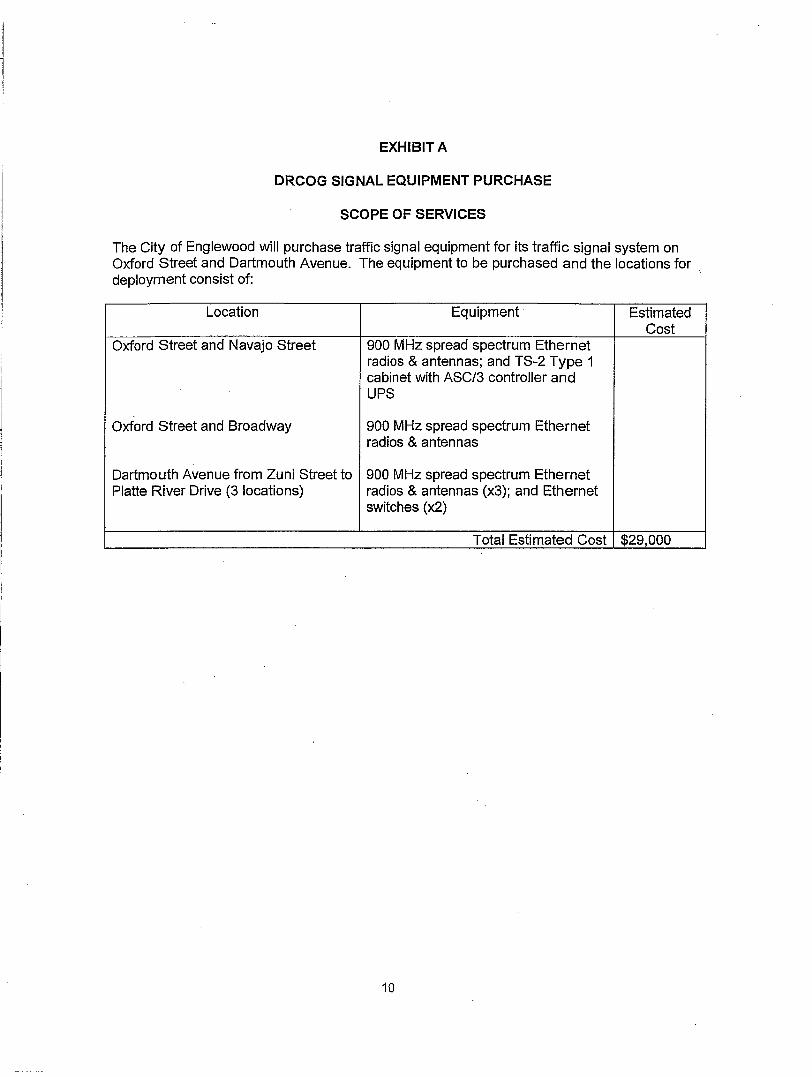
EXHIBIT A
DRCOG SIGNAL EQUIPMENT PURCHASE
SCOPE OF SERVICES
The City of Englewood will purchase traffic signal equipment for its traffic signal system on Oxford Street and Dartmouth Avenue. The equipment to be purchased and the locations for deployment consist of:
Location Equipment Estimated Cost
Oxford Street and Navajo Street 900 MHz spread spectrum Ethernet radios & antennas; and TS-2 Type 1 cabinet with ASC/3 controller and UPS
Oxford Street and Broadway 900 MHz spread spectrum Ethernet radios & antennas
Dartmouth Avenue from Zuni Street to 900 MHz spread spectrum Ethernet Platte River Drive (3 locations) radios & antennas (x3); and Ethernet
switches (x2)
Total Estimated Cost $29,000
10
COUNCIL COMMUNICATION
Date: Agenda Item: Subject:
November 19, 2012 9 c i Resolution modifying fees for Public Works Right-of-Way Permits
Initiated By: Staff Source:
Department of Public Works Dave Henderson, Engineering/Capital Projects Administrator
COUNCIL GOAL AND PREVIOUS COUNCIL ACTION
Council approved Resolution No. 34, Series 2003, establishing the Public Works permits fee schedule.
RECOMMENDED ACTION
Staff recommends Council approval of a Resolution modifying the Public Works Right-of-Way permit fee schedule.
BACKGROUND, ANALYSIS, AND ALTERNATIVES IDENTIFIED
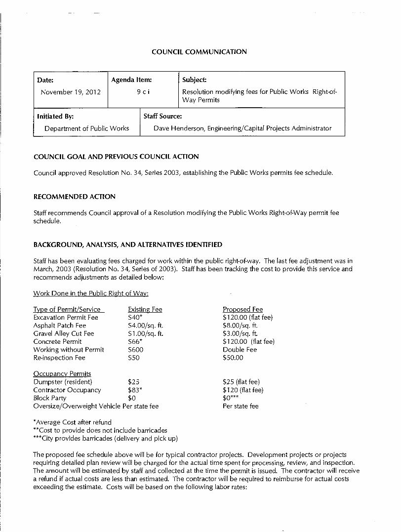
Staff has been evaluating fees ch'arged for work within the public right-of-way. The last fee adjustment was in March, 2003 (Resolution No. 34, Series of 2003). Staff has been tracking the cost to provide this service and recommends adjustments as detailed below:
Work Done in the Public Right of Way:
Type of Permit/Service Excavation Permit Fee Asphalt Patch Fee Gravel Alley Cut Fee Concrete Permit Working without Permit Re-inspection Fee
Occupancy Permits
Existing Fee $40* $4.00/sq. ft. $1.00/sq. ft. $66* $600 $50
Dumpster (resident) $25 Contractor Occupancy $83* Block Party $0 Oversize/Overweight Vehicle Per state fee
*Average Cost after refund **Cost to provide does not include barricades ***City provides barricades (delivery and pick up)
Proposed Fee $120.00 (flat fee) $8.00/sq. ft. $3.00/sq. ft. $120.00 (flatfee) Double Fee $50.00
$25 (flat fee) $120 (flat fee) $0*** Per state fee
The proposed fee schedule above will be for typical contractor projects. Development projects or projects requiring detailed plan review will be charged for the actual time spent for processing, review, and inspection. The amount will be estimated by staff and collected at the time the permit is issued. The contractor will receive a refund if actual costs are less than estimated. The contractor will be required to reimburse for actual costs exceeding the estimate. Costs will be based on the following labor rates:

Clerical Engineers Inspectors
$35.00 per hour $58.00 per hour $48.00 per hour
NOTE: Labor Rate = hourly rate+ Benefits + Indirect Costs
Our existing fee structure, as established in 2003, requires contractors to pay $200 for permits when issued, with refunds or reimbursements made after actual charges are calculated. In 99% of the cases, a refund is due. This process requires staff time for data entry, tracking inspection time, compiling charges from multiple divisions, forwarding the refund amount to the Finance Department, and processing and mailing refund checks for nearly all permits issued. This overhead has not been included in the cost we have charged for permits. As proposed, the new fee structure will be a flat fee that will eliminate most of this overhead associated with refunds.
The proposed fees will still be on the lower end of what most other local governments are charging (see the table below).
Excavation Asphalt
Excavation Gravel Concrete Dumpster
City in Street in Alley Alley Permit
Patch Permit Repair
Permit Permit
Sheridan $250 * $250 * $25 $0 Littleton $110 * $110 * $110 $0 Golden $120 $110 $120 N/A $215 $50 Centennial $315 $150 min. $315 * $340 $25 Englewood Proposed $120 $200 $120 $75 $120 $25
* "By Contractor" NOTE: Estimated fees based on 5' x 5' (25 sq. ft.)
FINANCIAL IMPACT
Additional revenue projections, based on the proposed fees, are in the neighborhood of $50,000 annually as detailed below:
Type of Permit/Service Excavation Asphalt Patch Gravel Alley Cut Concrete Permit Occupancy Permit
Existing Anticipated $8,000 $27,000 $2,000 $2,000 $3,000
LIST OF ATTACHMENTS
Resolution
Annual increase $25,000 $54,000 $6,000 $3,000 $4,000
$17,000 $27,000 $ 4,000 $ 1,000 $ 1,000 $50,000

RESOLUTION NO. SERIES OF 2012
A RESOLUTION APPROVING MODIFICATION FOR PUBLIC WORKS RIGHT -OF-WAY PERMITS FEES.
WHEREAS, the use of the Public Right-of-Way is a benefit to private individuals and companies; and
WHEREAS, that use of the public right-of-way requires costs to the City for engineering reviews or inspections as part of the use permit or development process; and
WHEREAS, City costs for managing the use of the public rights-of-way have increased since the current fees were set in 2003, and the new schedule is reasonably related to the City's costs; and ·
WHEREAS, the Englewood City Council approved the establishment of the Public Right-ofWay permit fees schedule by the passage of Resolution No. 34, Series of 2003.
NOW, THEREFORE, BE IT RESOLVED BY THE CITY COUNCIL OF THE CITY OF ENGLEWOOD, COLORADO, THAT:
Section 1. City Council hereby approves the following administrative and management fees:
Fee Schedule for Work Done in the Public Way: (These Fees maybe cumulative)
Type of Permit/Service
Excavation Permit Fee Concrete Permit Fee
Re-inspection Fee Asphalt Patch Fee Gravel Alley Cut Fee Working without Permit
Occupancy Permits:
Dumpster (resident) Contractor Occupancy Block Party Oversize/Over Weight Vehicle Per State Fee
$120.00 (flat fee) $120.00 (flat fee)
$ 50.00 $ 8.00/sq ft $ 3.00/sq ft Double the Permit Fee
$ 25.00 (flat fee) $120.00 (flat fee) $ 0 *** Per State Fee
***City provides barricades (delivery and pick up)

Development Project Fees:
The fee schedule above is for typical contractor projects. Development projects or projects requiring detailed plan review will be charged for the actual time spent for processing, review, and inspection (labor). The amount will be estimated by staff and collected at the time the permit is issued. The contractor will receive a refund if actual costs are less than estimated. The contractor will be required to reimburse for actual costs exceeding the estimate. Costs will be based on the following labor rates:
Clerical Engineers Inspectors
$35.00 per hour $58.00 per hour $48.00 per hour
NOTE: Labor Rates = Salary+ Benefits + Indirect Costs.
ADOPTED AND APPROVED this 19th day ofNovember, 2012.
ATTEST: Randy P. Penn, Mayor
Loucrishia A. Ellis, City Clerk
I, Loucrishia A. Ellis, City Clerk for the City of Englewood, Colorado, hereby certify the above is a true copy ofResolution No. __ , Series of2012.
Loucrishia A. Ellis, City Clerk

COUNCIL COMMUNICATION
Date: Agenda Item: Subject:
November 19, 2012 9 c ii Resolution establishing fees for Concrete Utility
Initiated By: Staff Source:
Department of Public Works Dave Henderson, Engineering/Capital Projects Administrator
COUNCIL GOAL AND PREVIOUS COUNCIL ACTION
Council approved Ordinance No. 36, Series of 1997, creating the Concrete Utility and Concrete Utility Enterprise Fund.
Council approved Council Bill No. 73, Series of 2008, amending the "User Fee" section of the Concrete Utility and Concrete Enterprise Fund (allows City Council to establish fees by resolution).
Council approved Resolution No. 79, Series 2008, establishing 2009 and 2010 fees for the Concrete Utility.
Council approved Resolution No. 84, Series 2009, canceling the 2010 fee increase for the Concrete Utility.
RECOMMENDED ACTION
Staff recommends Council approval of a Resolution establishing fees for the Concrete Utility.
BACKGROUND, ANALYSIS, AND ALTERNATIVES IDENTIFIED
Property owners in the City of Englewood are required to maintain concrete adjacent to their property. The Concrete Utility was adopted in 1997 to create a funding mechanism to assist owners with their responsibility in the repair of the City's aging concrete infrastructure. Participation in the program is voluntary, as owners have the option to "opt-out" ofthe Concrete Utility and maintain the concrete as required by Municipal Code Section 11-7-18. Approximately 96% of the 11,290 eligible properties in the City participate. The City participates in the costs for intersection corners, alley entrances, drainage cross pans, concrete pavement and alleys, and City owned properties; additionally, the City pays 70% of the avenue costs.
The Concrete Utility requires year round administration (billings, property realignments, concrete inventory, tracking new concrete installations, phone response, opt-in and opt-out requests, title company responses, and delinquent accounts). Additionally, administration of the annual construction project for the Concrete Utility takes approximately eight months from start to finish (initial ratings of concrete with pictures, contract quantity determination, bidding, construction administration, inspections, contract close out, and citizen response during construction). Three City employees, working for the Concrete Utility, handle the majority of these duties. The City's concrete infrastructure consists of 7,315,000 square feet of concrete worth an estimated cost of $54,000,000.
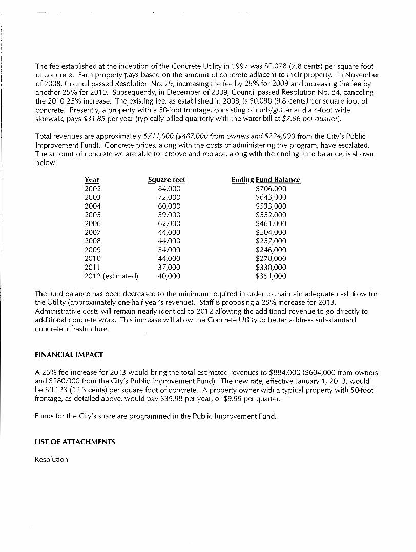
The fee established at the inception of the Concrete Utility in 1997 was $0.078 (7.8 cents) per square foot of concrete. Each property pays based on the amount of concrete adjacent to their property. In November of 2008, Council passed Resolution No. 79, increasing the fee by 25% for 2009 and increasing the fee by another 25% for 201 0. Subsequently, in December of 2009, Council passed Resolution No. 84, canceling the 201 0 25% increase. The existing fee, as established in 2008, is $0.098 (9.8 cents) per square foot of concrete. Presently, a property with a 50-foot frontage, consisting of curb/gutter and a 4-foot wide sidewalk, pays $31.85 per year (typically billed quarterly with the water bill at $7.96 per quarter).
Total revenues are approximately $711,000 ($487,000 from owners and $224,000 from the City's Public Improvement Fund). Concrete prices, along with the costs of administering the program, have escalated. The amount of concrete we are able to remove and replace, along with the ending fund balance, is shown below.
Year 2002 2003 2004 2005 2006 2007 2008 2009 2010 2011 2012 (estimated)
Square feet 84,000 72,000 60,000 59,000 62,000 44,000 44,000 54,000 44,000 37,000 40,000
Ending Fund Balance $706,000 $643,000 $533,000 $552,000 $461,000 $504,000 $257,000 $246,000 $278,000 $338,000 $351,000
The fund balance has been decreased to the minimum required in order to maintain adequate cash flow for the Utility (approximately one-half year's revenue). Staff is proposing a 25% increase for 2013. Administrative costs will remain nearly identical to 2012 allowing the additional revenue to go directly to additional concrete work. This increase will allow the Concrete Utility to better address sub-standard concrete infrastructure.
FINANCIAL IMPACT
A 25% fee increase for 2013 would bring the total estimated revenues to $884,000 ($604,000 from owners and $280,000 from the City's Public Improvement Fund). The new rate, effective january 1, 2013, would be $0.123 (12.3 cents) per square foot of concrete. A property owner with a typical property with 50-foot frontage, as detailed above, would pay $39.98 per year, or $9.99 per quarter.
Funds for the City's share are programmed in the Public Improvement Fund.
LIST OF ATTACHMENTS
Resolution

RESOLUTION NO. SERIES OF 2012
A RESOLUTION ESTABLISHING FEE SCHEDULES FOR THE CITY OF ENGLEWOOD CONCRETE UTILITY.
WHEREAS, the City of Englewood created the Concrete Utility and the Concrete Utility Enterprise Fund by the passage of Ordinance No. 36, Series of 1997; and
WHEREAS, the passage of Council Bill No. 73, Series of2008 amended the "User Fee" section of the Concrete Utility and Concrete Enterprise Fund establishing fees for the Concrete Utility to be set by Resolution; and
WHEREAS, the Englewood City Council approved the establishment of Concrete Fees for 2009 and 2010 by the passage of Resolution No. 79, Series of2008; and
WHEREAS, the Englewood City Council approved canceling the 2010 Concrete Fee increase for the Concrete Utility Program by the passage of Resolution No. 84, Series of 2009; and
WHEREAS, participation in the program is voluntary because property owners have the option to "opt-out" of the Concrete Utility and maintain the concrete as required by 11-7-18 EMC and approximately 96% of the 11,290 eligible properties in the City participate in the Concrete Utility Program; and
WHEREAS, the Concrete Utility requires year round administration (billings, property realignments, concrete inventory, tracking new concrete installations, phone response, opt-in and opt-out requests, title company responses, and delinquent accounts); and
WHEREAS, concrete prices, along with the costs to administer the Program have escalated since 2009, this rate increase will allow the Concrete Utility to better address sub-standard concrete infrastructure; and
WHEREAS, the amount that each property pays is based on the amount of concrete adjacent to their property;
NOW, THEREFORE, BE IT RESOLVED BY THE CITY COUNCIL OF THE CITY OF ENGLEWOOD, COLORADO, THAT:
Section 1. The Englewood City Council hereby authorizes the Concrete Utility Program Fees to be set at
$0.123 (12.3 cents) per square foot effective January 1, 2013.
1

r
ADOPTED AND APPROVED this 19th day of November, 2012.
ATTEST: Randy P. Penn, Mayor
Loucrishia A. Ellis, City Clerk
I, Loucrishia A. Ellis, City Clerk for the City of Englewood, Colorado, hereby certify the above is a true copy of Resolution No. __ , Series of2012.
Loucrishia A. Ellis, City Clerk
2
COUNCIL COMMUNICATION
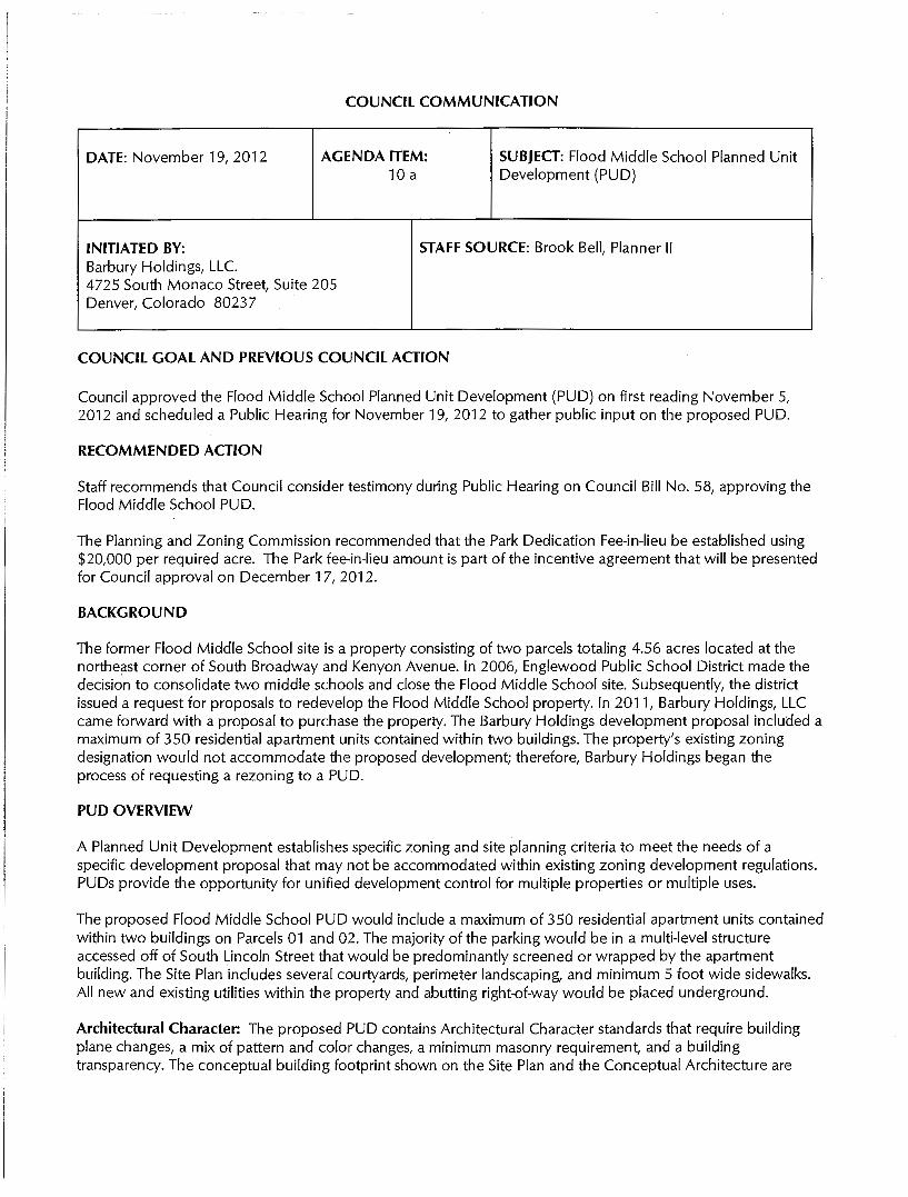
DATE: November 19,2012 AGENDA ITEM: SUBJECT: Flood Middle School Planned Unit 10 a Development (PUD)
INITIATED BY: STAFF SOURCE: Brook Bell, Planner II Barbury Holdings, LLC. 4725 South Monaco Street, Suite 205 Denver, Colorado 8023 7
COUNCIL GOAL AND PREVIOUS COUNCIL ACTION
Council approved the Flood Middle School Planned Unit Development (PUD) on first reading November 5, 2012 and scheduled a Public Hearing for November 19, 2012 to gather public input on the proposed PUD.
RECOMMENDED ACTION
Staff recommends that Council consider testimony during Public Hearing on Council Bill No. 58, approving the Flood Middle School PUD.
The Planning and Zoning Commission recommended that the Park Dedication Fee-in-lieu be established using $20,000 per required acre. The Park fee-in-lieu amount is part of the incentive agreement that will be presented for Council approval on December 17, 2012.
BACKGROUND
The former Flood Middle School site is a property consisting of two parcels totaling 4.56 acres located at the northeast corner of South Broadway and Kenyon Avenue. In 2006, Englewood Public School District made the decision to consolidate two middle schools and close the Flood Middle School site. Subsequently, the district issued a request for proposals to redevelop the Flood Middle School property. In 2011, Barbury Holdings, LLC came forward with a proposal to purchase the property. The Barbury Holdings development proposal included a maximum of 350 residential apartment units contained within two buildings. The property's existing zoning designation would not accommodate the proposed development; therefore, Barbury Holdings began the process of requesting a rezoning to a PUD.
PUD OVERVIEW
A Planned Unit Development establishes specific zoning and site planning criteria to meet the needs of a specific development proposal that may not be accommodated within existing zoning development regulations. PUDs provide the opportunity for unified development control for multiple properties or multiple uses.
The proposed Flood Middle School PUD would include a maximum of 350 residential apartment units contained within two buildings on Parcels 01 and 02. The majority of the parking would be in a multi-level structure accessed off of South Lincoln Street that would be predominantly screened or wrapped by the apartment building. The Site Plan includes several courtyards, perimeter landscaping, and minimum 5 foot wide sidewalks. All new and existing utilities within the property and abutting right-of-way would be placed underground.
Architectural Character: The proposed PUD contains Architectural Character standards that require building plane changes, a mix of pattern and color changes, a minimum masonry requirement, and a building transparency. The conceptual building footprint shown on the Site Plan and the Conceptual Architecture are
subject to change; however, any changes would have to meet the Development Standards and Architectural Character provisions of the PUD.
Permitted Uses: The Flood Middle School property lies within the following existing Zone Districts: MU-R-3-B, MU-B-1, and R-2-B; each of these zone districts has a list of permitted uses, including multi-unit dwellings. The proposed Flood Middle School PUD would allow multi-unit dwellings, surface parking, and parking garage as permitted uses regulated by the standards of the PUD. For all other uses, the proposed PUD would be regulated by the standards and provisions of the MU-R-3-B Zone District. The MU-R-3-B Zone District also permits hospital and other limited office uses without limitation on the concentration of the use, provided the parking standards can be met.
Dimensional Standards: The proposed dimensional standards for the Flood Middle School PUD vary from the existing underlying zone districts dimensional standards for residential uses in terms of minimum lot area, maximum lot coverage, minimum lot width, maximum height, and minimum setbacks.
Residential Density: Without a PUD rezoning, the existing Zone Districts occupied by the Flood Middle School property would permit approximately 164 dwelling units based on minimum lot area and where applicable, lot width. The proposed Flood Middle School PUD would permit a maximum of 350 units (31 0 units under the Planning and Zoning Commission condition) between Parcels 01 and 02; this represents a density of 76.75 dwelling units per acre (d.u.jac.). For comparison purposes the density at Orchard Place is 87 d.u.jac., the Terraces on Penn is 76 d.u./ac., Simon Center 76 d.u.jac., and Cherokee Kiva condos is 61 d.u.jac.
Setbacks: The building setbacks for the Flood Middle School PUD vary from 0 to 10 feet depending on which street or property line the building faces. Setbacks in the existing underlying zone districts vary from 0 to 25 feet for residential uses.
Building Height The maximum building heights in the PUD are based on United States Geological Survey (USGS) elevations. The height on Parcel 01 is U.S.G.S. 5,416' (approximately 60' to 78' from south to north). The maximum building height on Parcel 02 is U.S.G.S. 5,414' (approximately 60' to 70' from south to north). The maximum building heights in the existing underlying zone districts vary from 32' to 1 00' for depending on the district.
Bulk Plane: The Flood Middle School property is bounded by streets or an alley on all sides except for the eastern half of northern boundary of Parcel 02. The proposed PUD complies with the standard bulk plane on the eastern half of northern boundary of Parcel 02, but excludes the remainder of the side lot lines from the bulk plane requirement.
Parking: The proposed Flood Middle School PUDwill follow the standard parking regulations outlined in 16-6-4 of the Unified Development Code (UDC). With the current unit mix, this would amount to approximately 604 required parking spaces including guest parking. The majority of these spaces would be in the parking structure wrapped by the apartment building.
Traffic: The traffic impact study for the proposed Flood Middle School PUD shows an increase in overall traffic volume; however, the study concludes that the development can be accommodated by the existing study area roadways and intersections without modification, and without creating significant impacts to the study area through 2030. The traffic impact study was reviewed by the Public Works Traffic Division and CDOT who both concurred with its findings.
Signage: The proposed PUD will follow the signage regulations outlined in 16-6-13 of the UDC as amended except that the PUD would permit the maximum height a projecting sign to be 50 feet high rather than the UDC's maximum height limit of 25 feet.
Landscaping: The UDC requires that a minimum of 20% to 25% of a multi-unit dwelling property be landscaped for depending on the existing underlying zone district. The Flood Middle School PUD proposes a minimum of 15% of the property be landscaped (the Planning and Zoning Commission recommended that this be increased
to 20% as a condition of approval). Additionally, the UDC requires that a minimum of 70% of the required landscape be "living". The Flood Middle School PUD proposes that a minimum of 50% of the landscape be "living". The PUDwill meet the requirements of the UDC in terms of plant quantities and sizes; with 50% of the required trees being located between the building and street.
Screening and Fencing: The PUD proposes an 8 foot high fence/wall between the apartment building and existing residential uses at the northern boundary of Parcel 02. The fence/wall must be consistent with the overall building design. All other screening or fencing must comply with the requirements of the UDC.
Drainage: The proposed Drainage Plan and Preliminary Drainage Report were reviewed and approved by the City's Public Works Department.
City Ditch: The proposed development will require the relocation of the City Ditch and the dedication of associated easements by separate document.
Park Dedication: The UDC requires the dedication of park land or payment of a fee in lieu of dedication for all residential developments. Based on a maximum of 350 multi-unit dwellings, the UDC would require the proposed PUD to dedicate 6.74 acres of park land or payment of a fee in lieu of land dedication.
On September 4, 2012 City Council adopted a fee to be paid in lieu of dedication amount of $20,000 per required acre. Credit towards the dedication requirements for recreational amenities provided on-site by the developer and waivers of all or a portion of the remaining fee-in-lieu may be requested. The applicant has requested and Council has preliminarily agreed to a fee of $57,780 based on a development containing 300 units. Council may deliberate the final fee-in-lieu of dedication amount after consideration of the PUD on second reading. This incentive plus others will be by separate written agreement.
The City has received comments from citizens requesting that the existing green space on Parcel 02 be preserved as a park rather than be developed. The Flood Middle School property is owned by the Englewood School District and is not a City of Englewood dedicated park. The citizen comments and replies from the Mayor and Mayor ProTem are attached as Exhibits 1-0. The Park Master Plan does not recognize this area as being underserved or unserved, and no recommendations were made for developing a park at this location. The Park Master Plan also notes that the acquisition of new park land must be balanced with park development costs and ongoing maintenance costs. Since the Master Plan was adopted, the City has decided to invest in enhancing and improving access to existing parks.
Phasing: The initial demolition of the existing school demolition and environmental remediation will take approximately 3 months. This will be followed by approximately 22 months of new construction for the apartment buildings.
PLANNED UNIT DEVELOPMENT CONSIDERATIONS
The UDC requires that Council shall only approve a proposed PUD, if it finds that the proposed development complies with all applicable use, development, and design standards set forth in this Title that are not otherwise modified or waived according to the rezoning approval; and the proposed rezoning meets one of the following criteria:
a. That the proposed development will exceed the development quality standards, levels of public amenities, or levels of design innovation otherwise applicable under this Title, and would not be possible or practicable under a standard zone district with conditional uses or with a reasonable number of Zoning Variances or Administrative Adjustmentsi or
The proposed PUDwill exceed the development quality standards required by the UDC for residential development as follows:

• The UDC does not require that the majority of the parking for a residential development be provided in a multi-level structure that is predominantly screened or wrapped by the apartment building. The PUD proposes a parking garage that is effectively hidden from public view.
• The UDC requires that street-facing building facades be articulated by the use of 3 or more techniques which could include; a change in texture, appropriate window placement, and use exterior trim. The PUD proposes a greater level of building articulation including; a 5 foot minimum building plane change every 45 feet, a mix of pattern and color changes, a minimum 30 percent masonry requirement, and a building transparency requirement at the corner of Broadway and Kenyon.
b. That the property cannot be developed, or that no reasonable economic use of the property can be achieved, under the existing zoning, even through the use of conditional uses or a reasonable number of Zoning Variances or Administrative Adjustments.
The Flood Middle School property has been vacant since the school closed in 2007; shortly thereafter, the Englewood Public School District issued a request for proposals to redevelop the site. Since that time, no viable development proposal has come forward except for the PUD application for the multi-unit residential development currently under consideration. Prior to filing the PUD application, Barbury Holding LLC researched various uses and the market for redeveloping the subject property. Their conclusions regarding various potential use alternatives are summarized as follows:
• Meetings with professional retail brokers revealed that there was not a strong interest in the site; in part, because the retail market contracted with the recession, and the access to the site is deemed to be undesirable for regional retail. Additionally, there is already an adequate supply available for any neighborhood retail demand.
• In terms of office, medical office, hospital, and hotel uses; the applicant enlisted help from a medical office consultant, a medical office broker, and hotel developers. They found that there that there was not a significant combination of drivers or demand to make these types of development feasible at this time.
• The applicant commissioned a preliminary study to evaluate the site for various senior housing options. Their study found that while a portion of the site could be attractive for senior housing, the economics would not reasonably support a viable development.
• Barbury Holdings enlisted a multi-family residential broker, who found that there was a market for a larger apartment project. The site was then marketed to over 3,000 apartment builders. Through this effort Wood Partners was identified as the preferred builder. In order to make the redevelopment economically feasible, it was determined that the project would require a significantly greater density than the current zoning on the property provides.
In addition to the two Planned Unit Development considerations above; the UDC requires that a property rezoned to PUD must not have a significant negative impact on those properties surrounding the rezoned area and that the general public health, safety and welfare of the community are protected. The Planning and Zoning Commission's Findings of Fact and Conclusions state the following:
• The PUD application is in conformance with the Comprehensive Plan and the Unified Development Code.
• The application is consistent with adopted and generally accepted standards of development in the City. • The property cannot be developed under the existing zoning. • The resulting rezoned property will not have a significant negative impact on those properties
surrounding the rezoned area and that the general public health, safety and welfare of the community are protected.
FINANCIAL IMPACT
The proposed Flood Middle School redevelopment will generate a one-time building use tax of $600,000 to $700,000 based on a construction cost of $35 to $40 million. If Council concurs with the previously adopted

park dedication fee, the project would also generate a one-time park dedication fee-in-lieu of approximately $120,000 based on 31 0 residential units.
As the site transitions from school property to a private residential development, additional property tax revenues are estimated at $11,000 to $14,000 per year. New residents living in the City will also generate sales tax revenue.
If the incentive request submitted by the developer receives approval, the one-time building use tax would be reduced by $170,000 and the park fee-in-lieu would be reduced by 50%. There are also costs associated with providing services such as police and fire; it is difficult to estimate what these projected costs will be.
LIST OF ATTACHMENTS
Planning Commission Staff Report including Exhibits A- L (September 18, 2012) Planning Commission Minutes (September 18 and October 2, 2012) Planning Commission Findings of Fact Exhibit M: Email from Mr. Forney- Dated September 24, 2012 Exhibit N: Letter from Mrs. McGovern- Dated September 26, 2012 Exhibit 0: Email from Mrs. Schell - Dated September 27, 2012 Exhibit P: Traffic Impact Study and Appendix A Bill for Ordinance
{' c T y 0 F ENGLEWOOD
COMMUNITY DEVELOPMENT
TO: Planning and Zoning Commission THRU: FROM:
Alan White, Community Development Director Brook Bell, Planner II V
DATE: September 18, 2012 '
SUBJECT: Case ZON2012-003 - Public Hearing Flood Middle School Planned Unit Development
Case SUB2012-002- Public Hearing Alta Cherry Hills Subdivision
APPLICANT: Barbury Holdings, LLC. 4725 South Monaco Street, Suite 205 Denver, Colorado 8023 7
PROPERTY OWNER: Englewood School District #1 4101 South Bannock Street Englewood, Colorado 80110
PROPERTY ADDRESS: 3695 South Lincoln Street PIN#'s: 2077-03-1-08-004 and 2077-03-1-09-006
REQUEST: The applicant has submitted an application to rezone the parcels above from MU-R-3-B, MU-B-1, .and R-2-B Zone Districts to Planned Unit Development (PUD). The proposed PUD would allow a maximum of 350 residential apartment units contained within two buildings. The applicant has also submitted an application for a Major Subdivision for the property contained in the PUD.
RECOMMENDATION: Case ZON2012-003: The Department of Community Development recommends that the Planning and Zoning Commission review the Flood Middle School PUD request and forward a favorable recommendation for approval to City Council.
1000 Englewood Parkway Englewood, Colorado 80110 PHONE 303-762-2342 FAX 303-783-6895 www.englewoodgov.org

Case SUB2012-002·: The Community Development Department recommends approval of the Preliminary Plat of the Alta Cherry Hills Subdivision. If the Commission requires no changes from the Preliminary Plat to the Final Plat, staff recommends that the Final Plat be forwarded to Council with a recommendation for approval.
LEGAL DESCRIPTIONS: PIN#: 2077-03-1-08-004 Lots 6-45 except a 25 Foot x 25 Foot Parcel Deeded for Roadway in Northwest Corner of Block 1 Higgins Broadway Addition.
PIN#: 2077-03-1-09-006 Lots 15-35 Block 2 Higgins Broadway Addition except Alley between Lots 15 & 16.
EXISTING ZONE DISTRICTS: MU-R-3-B Mixed-Use High Density Residential and Limited Office District, MU-B-1 MixedUse Central Business District, and R-2-B Medium Density Single and Multi-Dwelling Unit Residential District.
PROPERTY LOCATION AND SURROUNDING LAND USE: The subject property of this PUD is located on two parcels (see Sheet 3 and 4 of PUD). Parcel 01 is ·located at the northeast corner of South Broadway and East Kenyon Avenue. Land to the north of.Parcel 01 is zoned MU-B-1 Mixed-Use Central Business District and contains the US 265/South Broadway interchange and open space. Land to the west of Parcel 01 is zoned MU-B-2 Mixed-Use General Arterial Business District and contains commercial uses. Land to the south of Parcel 01 and west of the alley is zoned MU-B-2 and contains commercial uses. Land south of Parcel 01 and east of the alley is zoned R-2-A and contains low density single and multi-unit dwellings. Parcel 02 is located at the northeast corner of South Lincoln Street and East Kenyon Avenue. Land to the north of Parcel 02 is zoned MU-R-3-B Mixed-Use High Density Residential and Limited Office District, and contains multi-unit dwellings. Land to the east of Parcel 02 is zoned R-2-B Medium Density Sin'gle and Multi-Dwelling Unit Residential District., and contains multi-unit dwellings. Land south of Parcel 02 is zoned R-2-A and contains low density single and multi-unit dwellings.
PUD AND SUBDIVISION PROCEDURE: Rezoning to a PUD requires the applicant to have a pre-application meeting with staff, a neighborhood meeting with owners and tenants located within 1,000 feet of the proposed PUD. After the neighborhood meeting a formal application is made to the City and reviewed by City departments and other affected outside agencies. A public hearing is held before the Planning and Zoning Commission and City Council. If the PUD is approved there is a 30 day referendum time period before becoming effective.
Since the information required and testimony necessary for both the P{JD and Subdivision cases are parallel, the requests are being considered within a single hearing; however, each case will require a separate motion from the Planning Commission.
2

BACKGROUND: The Planned Unit Development is a rezoning process that establishes specific zoning and site planning criteria to meet the needs of a specific development proposal that may not be accommodated within existing zoning development regulations. A PUD rezoning provides the opportunity for unified development control for multiple properties or multiple uses.
In 2006, Englewood Public School District made the decision to consolidate two middle schools and close the Flood Middle School site. The school then closed in 2007. Subsequently, the district issued a request for proposals to redevelop the Flood Middle School property. In 2011, Barbury Holdings, LLC. came forward with a proposal to purchase the property consisting of two parcels totaling 4.56 acres. Barbury Holdings development proposal included a maximum of 350 residential apartment units contained within two buildings. The property's existing zoning designation would not accommodate the proposed developmenti therefore, Barbury Holdings began the process of requesting a rezoning to a PUD. A preliminary subdivision plat, based on the PUD, was also submitted.
NEIGHBORHOOD MEETING SUMMARY: Pursuantto the PUD procedure, the applicant conducted a neighborhood meeting on May 16, 2012, prior to submitting the application for a PUD rezoning on june 4, 2012. Notice of the pre-application meeting was mailed to property owners and occupants of property within 1000 feet of the site. Neighborhood meeting notes are attached to this report (See Exhibit D).
CITY DEPARTMENT AND DIVISION REVIEW: The Flood Middle School PUD, Alta Cherry Hills Subdivision, and subsequent revisions were reviewed by the City's Development Review Team (DRT) on june 30th, August 1oth, and August 30th of 2012. Identified issues were addressed by the applicant and the final Flood Middle School PUD and Alta Cherry Hills Subdivision were submitted on September 7, 2012.
OUTSIDE AGENCY COMMENTS: Preliminary plans of the proposed Flood Middle School PUD and Alta Cherry Hills Subdivision were referred to Tri-County Health, the Colorado Department of Transportation (COOT), RTD, Xcel Energy, Century Link, Comcast, and the City's list of trash haulers for review and comment. Tri-County Health, COOT, Xcel Energy, and Century Link provided written comments that are attached as Exhibits E-H. There. were no objections in the comments received provided that the applicant continues working with the agencies' individual processes. If any other formal comments are received before the public hearing, Staff will present them during the hearing. RTD and the trash haulers did not provide comments.
PUD OVERVIEW: The proposed Flood Middle School PUD would include a maximum of 350 residential apartment units contained within two buildings on Parcels 01 and 02. The majority of the parking would be in a multi-level structure accessed off of South Lincoln Street that would be predominantly screened or wrapped by the apartment building. The Site Plan includes
3

several courtyards, perimeter landscaping, and minimum 5 foot wide sidewalks. All new and existing utilities within the property and abutting right-of-way would be placed underground.
Architectural Character: The proposed PUD contains Architectural Character standards that require building plane changes every 45 feet, a mix of pattern and color changes, a minimum 30 percent masonry requirement, and a building transparency requirement at the corner of Broadway and Kenyon. It should be noted that the conceptual building footprint shown on the Site Plan and the Conceptual Architecture are subject to change; however, any changes would have to meet the Development Standards and Architectural Character provisions of the PUD.
Permitted Uses: The Flood Middle School property lies within the following existing Zone Districts: MU-R-3-B, MU-8-1, and R-2-8; each of these zone districts has a list of permitted uses, including multi-unit dwellirygs. The proposed Flood Middle School PUD would allow multi-unit dwellings, surface parking, and parking garage as permitted uses regulated by the standards of the PUD. For all other uses, the proposed PUD would be regulated by the standards and provisions of the MU-R-3~8 Zone District.
Dimensional Standards: The following table provides a comparison between the property's existing zone classifications and the proposed PUD.
One-Unit Dwelling 6,000 None 40 50 32 25 5 20
Multi-Unit Dwelling (Maximum Units
3,000 per unit 60 25 per
32 25 5 20 Based on Lot Area & unit Lot Width)
None
All Other Allowed 24,000 None 60 200 32 25 25 25
Uses
4

One-Unit Dwelling
Multi-Unit -Dwelling (Maximum Units Based on Lot Area & Lot Width)
Office, Limited
All Other Allowed
Live/Work Dwelling
Multi-Unit Dwelling
All Other Allowed Uses
Multi-Unit Dwelling and Parking Structure
Surface Parking
6,000
2-4 units: 3,000 per unit;
Each additional unit over 4 units: 1,000
per unit; for properties over 1
acre: 1,089 per unit or 40 units acre
24,000
24,000
None
None
None
567 per unit or 76.75 units per acre for Parcels 01 and 02
combined
None
None
None
1.5 (Excluding ·the area of
None
None
None
None
None
None
40
75
75
75
None
None
None
Parcel 01: 75
Parcel 02: 80
Same as above
50
None
None
None
None
None
None
None
None
32
2-4 units: 32
More than 4 units: 60
60
60
100
100
100
Parcel 01: +/-60-78; Parcel 02: +/-60-78
NA
15
15
15
15
Max· ofO to 5 feet Max
ofOto 5 feet Max
ofOto 5 feet
5
2-4 units:
5
More than4 units:
15
15
15
0
0
0
20
25
25
25
5
5
5
Varies depending on street frontage: 0 to 10
feet, see PUD
From Buildings: 0 From Public ROW: 5
Residential Density: Without rezoning, the existing Zone Districts occupied by the Flood Middle School property would permit the following amount of dwelling units based on minimum lot area and where applicable, lot width:
Zone District Total Lot Area Total Lot Width (Frontage) R-2-B (Parcel 02) 33,187 SF MU-R-3-B (Parcel 02) 33,187 SF MU-R-3-B (Parcel 01) 119,243 SF MU-B-1 (Parcel 01) 13,187 SF Note: MU-B-1 figured at one unit per 1,089 SF
5
250 LF N/A N/A N/A
TOTAL
# of Dwelling Units 10 33
109 12
164 Units

The proposed Flood Middle School PUD would permit a maximum of 350 units between Parcels 01 and 02; this represents a density of 76.75 dwelling units per acre.
Setbacks: A setback is the minimum distance a structure must be located from a property line. The proposed PUD's setbacks are as follows: From Broadway- 0 feet From Kenyon - 1 0 feet From Lincoln - 5 feet From Sherman - 1 0 feet From the northern property lines - 1 0 feet except where Parcel 02 meets alley - 5 feet
Building Height: The maximum building heights in the PUD are based on United States Geological Survey (USGS) elevations. The maximum building height on Parcel 01 is U.S.G.S. elevation 5,416' (approximately 60' at the south property line, to 78' at the north property line). The maximum building height on Parcel 02 is U.S.G.S. elevation 5,414' (approximately 60' at the south property line to 70' at the north property line).
Bulk Plane: The R-2-B and MU-R-3-B zone districts have a bulk plane that regulates building mass on side Jot lines. The bulk plane is figured from the midway point along the side Jot line, measured 12' vertically, and then at a 45 degree angie towards the center of the property. The Flood Middle School property is bounded by streets or an alley on all sides except for the eastern half of northern boundary of Parcel 02. The proposed PUD complies with the standard bulk plane on the eastern half of northern boundary of Parcel 02 but excludes the remainder of the side Jot Jines from the bulk plane requirement.
Parking: The proposed Flood Middle School PUD will follow the parking regulations outlined in 16-6-4 of the Unified Development Code (UDC). These requirements are 1.5 spaces for each studio, 1 bedroom, or 2 bedroom unit; and 2 spaces for each 3 bedroom unit; plus 1 guest space for every 5 units. With the current unit mix, this would amount to approximately 604 required parking spaces. The majority of these spaces would be in the parking structure wrapped by the apartment building. Bicycle parking will be required at a rate of one bicycle space for every two units.
Traffic: A traffic impact study wa:s performed for the proposed Flood Middle School PUD. The traffic study shows an increase in overall traffic volume; however, the development can be accommodated by the existing study area roadways and intersections without modification and without creating significant impacts to the study area through 2030. The traffic; impact study was reviewed by the Public Works Traffic Division and COOT who both concurred with its findings.
Signage: The proposed PUDwill follow the signage regulations outlined in 16-6-13 of the UDC as amended except that the PUD would permit the maximum height a projecting sign to be 50 feet high rather than the UDC's maximum height limit of 25 feet.
6

Landscaping: The UDC requires that a minimum of 25% of the property be landscaped for multi-unit dwellings in the R-2-B and MU-R-3-B zone districts and 20% in the MU-B-1 zone district. The Flood Middle School PUD proposes a minimum of 15% of the property be landscaped. Additionally, the UDC requires that a minimum of 70% of the required landscape be "living" landscape. The Flood Middle School PUD proposes that a minimum of 50% of the landscape be "living". This is due in part to the urban nature of the project that may include specialty paving, plazas, water features, etc. as "non-living" landscape. The PUD will meet the requirements of the UDC in terms of plant quantities and sizes; additionally, 50% of the required trees must be located between the building and street which will result in street trees for the project.
Screening and Fencing: The PUD proposes an 8 foot high fence/wall between the apartment building and existing residential uses at the northern boundary of Parcel 02. The fence/wall must be consist~nt with the overall building design. All other screening or fencing must comply with the requirements of the UDC.
Drainage: The proposed Drainage Plan and Preliminary Drainage Report were reviewed and approved by the City's Public Works Department.
City Ditch: The existing City Ditch runs through Parcel 01 and the northeast corner of Parcel 02. The proposed development will require the relocation of the City Ditch and the dedication of associated easements by separate document.
Park Dedication: The subdivision regulations of the UDC require the dedication of park land or payment of a fee in lieu of dedication for all residential developments. The UDC provides a method for determining the amount of land to be dedicated based on the number of units and the number of new residents that will be generated. Based on a maximum of 350 multi-unit dwellings, the proposed Flood Middle School PUD would require a park dedication of 6.74 acres of land or payment of a fee in lieu of land dedication.
On September 4, 2012 City Council adopted a fee to be paid in lieu of dedication amount of $20,000 per required acre. Credit towards the dedication requirements for recreational amenities provided on-site by the developer and waivers of all or a portion of the remaining fee-in-lieu may be requested. Requests are considered on a case-by-case basis at the discretion of CounCil. Council will be considering the final fee-in-lieu of dedication amount concurrently or shortly after approval of the PUD. The applicant has requested and Council has preliminarily agreed to a fee of $57,780 based on a development containing 300 units.
The City has received comments from citizens requesting that the existing green space on Parcel 02 ·be preserved as a park rather than be developed. The Flood Middle School property is owned by the Englewood School District and is not a City of Englewood dedicated park. The citizen comments and replies from the Mayor and Mayor Pro Tern are attached as Exhibits 1-L. The Park Master Plan does not recognize this area as being underserved or unserved, and no recommendations were made for developing a park at this location. The Park Master Plan also notes that the acquisition of new park land must be
7
balanced with park development costs and ongoing maintenance costs. Since the Master Plan was adopted, the City has decided to invest in enhancing and improving access to existing parks.
Phasing: The initial demolition of the existing school demolition and environmental remediation will take approximately 3 months. This will be followed by approximately 22 months of new construction for the apartment buildings.
PUD SUMMARY: The proposed Flood Middle School PUD has been reviewed by the City's Development Review Team (DRT) and the appropriate outside agencies. Issues identified by the DRT Were addressed by the applicant and there were no objections from the outside agencies provided that the applicant continues working with the agencies' individual processes. The PUD documents are complete and no additional conditions of approval are recommended at this time. Therefore, the Community Development Department recommends that the Planning and Zoning Commission review the Flood Middle School PUD request and forward a favorable recommendation for approval to City Council.
PLANNED UNIT DEVELOPMENT CONSIDERATIONS: The Planning and Zoning Commission is to review the Flood Middle School PUD request, and following the public hearing, may recommend that the Council approve, deny, or approve the rezoning with conditions. In its review of the application, the Commission's recommendations should include findings on each of the following points:
1. The application is or is not in conformance with the Comprehensive Plan and this Title (UDC).
The Flood Middle School PUD conforms to the Comprehensive Plan strategy of redevelopment. The Comprehensive Plan states, "Englewood residents will benefit from the. new opportunities for housing, shopping, and entertainment these new developments will bring to the City". The proposed PUD supports the following Comprehensive Plan Housing Goal #1: "Promote a balance mix of housing opportunities serving the needs of all current and future Englewood citizens."
Additionally the PUD documents states: "The proposed project address·es the City's 3-part strategy outlined in the 2003 Englewood Comprehensive Plan for Growth and Development in the City; Revitalization, Redevelopment and Reinvention. The abandoned Flood Middle School currently occupies this site. The proposed project will redevelop this site into a vibrant, high quality residential community that fits into the existing mix of uses that surround the site that include a mix of single family, duplex and multi-family residences, as well .as commercial/retail uses. This project will revitalize this established neighborhood area and provide a unique housing option for residents in this location. This project takes advantage of existing community infrastructure and transportation options while rein-vesting in an existing established neighborhood. The additional residents will take advantage of the
8
existing retail in the neighborhood and generate tax revenue that will benefit programs and services provided by the City of Englewood."
The increased tax revenue will also benefit other taxing entities, most notably the School District.
2. The application is or is not consistent with adopted and generally accepted standards of development in the City.
The Flood Middle School PUD is consistent with adopted and generally accepted development standards established by the City of Englewood. The application was reviewed by the City's Development Review Team (DRT) and the appropriate outside agencies. All comments were addressed by the applicant.
3. The application is or is not substantially consistent with the goals, objectives, design guidelines, policies and any other ordinance, law, or requirement of the City.
The Flood Middle School PUD is substantially consistent with the goals, objectives, design guidelines, policies, and other ordinances, laws and requirements of the City.
SUBDIVISION SUMMARY: The proposed Preliminary Plat of the Alta Cherry Hills Subdivision has been reviewed by the City's Development Review Team (DRT} and the appropriate outside agencies. The Alta Cherry Hills Subdivision includes: • The vacation of alleys on Parcel 01 and 02. • The vacation of platted lot lines. • The relocation/dedication of a portion of the east-west leg of the alley on Parcel 02. • The dedication of public right-of-way on north edge of East Kenyon Avenue. • The dedication of utility easements on Parcel 02 along South Sherman Street and East
Kenyon Avenue. • A utility easement on Parcel 02 to be vacated by separate document. • A city ditch easement to be dedicated by separate document. • A pedestrian access easement to be dedicated by separate document.
Issues identified by the DRT were addressed by the applicant and there were no objections from the outside agencies provided that the applicant continues working with the agencies'
·individual processes. Therefore, the Community Development Department recommends approval of the Preliminary Plat of. the Alta Cherry Hills Subdivision. If the Commission requires no changes from the Preliminary Plat to the Final Plat, staff recommends that the Final Plat be forwarded to Council with a recommendation for approval.
SUBDIVISION CONSIDERATIONS: When considering a subdivision plat, the Commission must consider the following:
1. The zoning of the property proposed for subdivision, together with the zoning of the areas immediately adjacent thereto.
9

The proposed Flood Middle School PUD use is multi-unit dwelling with a wrapped parking garage and limited surface parking; these uses are compatible with adjacent City of Englewood R-2-B, MU-R-3-B, and MU-B-1 zone district uses.
2. The proposed layout of lots and blocks and the proposed dimensions thereof to demonstrate compliance with yard area requirements.
The proposed lots are compatible with dimensions established by the Flood Middle School PUD.
3. The availability of all utilities, and the proximity thereof to the area proposed for subdivision.
Public water and sewer along with electric, gas, and communication utilities are available to the subject property.
4. Topography and natural features of the land with special reference to flood plains.
The subject property is not located within an identified flood plain zone.
5. The continuity of streets and alleys within the area proposed for subdivision, and the design and location of such streets and alleys, with relation to existing streets and alleys, both within and without the area proposed for subdivision, and the Master Street Plan.
The relocation of a portion of the public alley proposed within this subdivision provides · the necessary access to the lots adjacent to the subdivision.
6. All rights-of-way to be designated and located to facilitate the safe movement of pedestrians and bicyclists.
Minimum 5 foot wide sidewalks are provided.
7. All bicycle and pedestrian facilities shalf be selected, located and designed in accordance with current City standards.
No bicycle facilities are required for this proposed subdivision. Sidewalks are provided.
8. The location of utility and other easements.
See Preliminary Plat.
9. The location ot and provision for, public areas, including land reserved for parks, schools and other public uses.
10

Council will be considering a final fee-in-lieu of land dedication amount once the PUD process is completed. The easements necessary for public uses and utilities are either dedicated on the subdivision plat or are to be dedicated by separate document.
7 0. The method of handling drainage and surface water.
A drainage study has been completed as part of the proposed Planned Unit Development application. Drainage issues have been addressed and will be monitored in the development permit process.
A IT ACHMENTS: Exhibit A: Flood Middle School PUD Exhibit B: Preliminary Plat of the Alta Cherry Hills Subdivision Exhibit C: Final Plat of the Alta Cherry Hills Subdivision Exhibit D: Neighborhood Meeting Summary- May 16, 2012 Exhibit E: Tri-County Health Department- Letter dated june 28, 2012 Exhibit F: COOT Region 6 - Letter dated August 31, 2012 Exhibit G: Xcel- Letter dated August 22, 2012 Exhibit H: Century Link- Letters dated july 23 and june 26, 2012 Exhibit 1: Email from Mr. Hannen and Mayor's response- Dated August 28, 2012 Exhibit J: Email from Mr. Blomstrom - Dated August 28, 2012 Exhibit K: Email from Mr. Anthony and Mayor Pro Tern's response- Dated August 29, 2012 Exhibit L: Email from Mr. and Mrs. Mears- Dated August 31, 2012
11

' ... •:
·~.
··~ .,r I
I I
VICINITY MAP
LEGAL DESCRIPT.ION
ENGLEWOOD HIGH
SCHOOL
Lors 13THROUGH 19, INCWSIVE AND 26 THROUI>H ss, 1NcLUs1ite, BLOcK 1; HiGGINS BROADWAY ADDITION, · . • • ' ' • . .COUNTY OF ARAPAHOE, STATIE OF COLORApO; 1\ND . LOTS 20 THROUGH 25, BLOCK 1, HIGGINS BROADWAY ADDITION, COUNTY OF ARAPAHOE, STATIE OF COLORADO; AND LOTS 10,11 AND 12, BLOCK 1, HIGGINS BROADWAY )\[)QITION, COUNTY OF ARAPAHOE, STATE OF COLORADO; AND . LOTS 6 THROUGH 9, INCWSIVEAND 39 THROUGH So, INCLUSIVE, BLOCK 1,-HIGGINS BROADWAY ADDITION, . . .. COUNTY OF ARAPAHOE, STATE OF COLORADO,
EXCEPT THAT PORTION CONVEYED TO THE CITY OF ENGLEWOOD IN DEED RECORDED .jANUARY 24, 1 9581N BOOK 952 AT PAGE 79 AND THAT PORTION CONVEYED TO THE STATE DEPARTMENT HIGHWAYS, 'DIVISION. OF HIGHWAYS, STATE OF . COLORADO IN DEED RECORDED JULY 21,1~70 IN BOOK 1875 AT PAGE 110.
TOGETHER WITH
LOT 30 AND THE SOUTH ONE HALF OF LOT 31, BLOCK 2, HIGGINS BROADWAY ADDITION, COUNTY OF ARAPAHOE, STATE OF COLORADO; AND LOTS 17 AND 18, BLOCK 2, HIGGINS BROADWAY ADDITION, COUNTY OF ARAPAHOE, STATE OF COLORADO; AND LOT 19 AND THE NORTH ONE HALF OF LOT 20, BLOCK 2, HIGGINS BROADWAY ADDITION, COUNTY OF ARAPAHOE, STATE OF COLORADO; AND · THE NORTH ONE HALF OF LOT 31.AND ALL OF LOT 32, BLOCK 2, HIGGINS ~ROADWAY ADDITION, COUNTY OF ARAPAHOE, STATE OF COLORADO; AND . LOTS 24 AND 25, BLOCK 2, HIGGINS BROADWAY ADDITION, COUNTY OF ARAPAHOE, STATE OF COLORADO; AND .. THE SOUTH ONE HALF OF LOT 20 AND ALL OFLOT 21, ~LOCK 2, HIGGINS BROADWAY ADDITION, COUNTY OF ARAPAHOE, STA TIE OF COLORADO; AND LOTS 28 AND 29, BLOCK 2, HIGGINS BROADWAY ADDITION, COUNTY OF ARAPAHOE, STATE OF COLORADO; AND LOTS 33, 34 AND 35, BLOCK 2, HIGGINS BROADWAY ADDITION, COUNn' OF ARAPAHOE, STATE OF COLORADO; AND LOTS 26 AND 27, BLOCK 2, HIGGINS BROADWAY ADDITION, COUNTY OF ARAPAHOE; STATE OF COLORADO; AND LOTS 22AND 23, BLOCK 2, HIGGINS BROADWAY ADDITION, COUNTY OF ARAPAHOE, STATE OF COLORADci; AND LOTS 15AND 16, BLOCK 2, HIGGINS BROADWAY ADDITION, COUNTY OF ARAPAHOE, STATE OF COLORADO, EXCEPT THAT PORTION CONVEYED TO THE CITY OF ENGLEWOOD BY DEED RECORDED OCTOBER 21, 19641N BOOK 1554ATPAGE390.
CONTAINING A TOTAL AREA OF 198,804 SQUARE FEET Of\4.56 ACRES.
FLOOD MS PLANNED UNIT DEVELOPMENT ENGLEWOOD, COLORADO
.PROJECT BACKGROUND . .
THIS PROJECT AT 3650 S. BROADWAY IS COMPRISED OF 2 PARCELS (PARCEL I.D #2077.03·1.08-004 & #2077.03·1·09·006) TOTALING APPROXIMATELY 4.6 ACRES. THE RRST (WEST) PARCEL (KNOWN HEREIN AS PARCEL 01) IS LOCATED AT THE NORTHEAST CORNER OF S. BROADWAY AND E. KENYON. THE SECOND (EAST) PARCEL (KNOWN HEREIN AS PARCEL02) IS LOCATED DIRECli.Y EAST OF THE wEST PARCEL A TTHE NORTHEAST CORNER OF S. LINCOLN AND E. KENYON. PRESENTLY THE WEST'PARCEL CONTAINS, THE NOW CLOSED, FLOOD MIDDLE SCHOOL WHICH WILL BE DEMOLISHED ASA PART OF THIS PROPOSED DEVELOPMENT. THE EAST PARCEL IS VACANT. THE CURRENT ZciNING OF Ti;E\io\IEST PARCEL IS MU·R-3·B WITH THE NORTHERNMOST MOST PORTION BEING ZONED MU·B·1. THE WEST . HALF OF THE EAST PARCEL IS.MU·R·3·BAND THE EASi liALF OF THE EAST PARCEL ZONED R-2~8. THIS P.UD WILL BRING ALL PARCELS UNDER THE SAME ZONING DESIGNATION AS OUTliNED WITHIN THIS ' PUC DOCUMENT. THE PLANNED UNIT DEVELOPMENT WILL BE PROCESSED PURSUANT TO THE APPLICABLE CITY REGULATIONS; •. "
CONSTRUCTIONIPHASit:IG PLAN
INITIAL DEMOLITION OF THE EXISTING BUILDINGS ON.SITE SHALL TAKE APPROXIMATELY 3 MONTHS:' . . ONCE DEMOLITION IS COMPLETE NEW CONSTRUCTION SHALL TAKE APPROXIMATELY 22 MONTHS: 'iT· · ISAilTICIPATED THAT THE FIRST RESIDENTIAL UNITS WILL BE READY FOR OCCUPANCY • APPROXIMATELY 12 MONTHS AFTER NEW CONSTRUCTION BEGINS.
. PUD DEVELOPM,ENT !)UMMARY · .. "~ .. : . ' ~ ·. ~·
THE APPLICANT PROPOSEs TO DEVELOP A MAxiMUM OF 360 RESIDENTIAL 'FOR· RENT' APAATMENr '.': 0
;
UNITS CONTAINED WITHIN TWO BUILDINGS DEVELci~ED ON PARCa01 AND PARCEL 02. P!\RKtNG • • •1:· SHALL MOSTLY BE PROVIDED IN A PARKING STRUCTURE THAT WILL PREDOMINANTLY BE • · '·· WRAPPED/SCREENED BYTHE APARTMENT BUILDING, VEHICULAR AND BICYCLE PARKING SHALL BE': :,. PROVIDED BASED ON MINIMUM CITY CODE REQUIREMENTS. SEVERAL COURTYAAD/AMEN.ITY AREASt•," ARE INCORPORATED INTO THE DESIGN THAT WILL ALSO INCLUDE lANDSCAPING. • '<~~~:
THE PROPOSED PROJECT ADDRESSES THE CITY'S 3.PART STRATEGY OUTLINEii IN THE 2003. • ~: :.:::~; ENGLEwOOD COMPREHENSIVE PLAN FOR GROWTH. AND DEVElOPMENT IN THE CITY; REVITALizAiio,i'( REDey):LOPMENT AND REINVENTION. THE ABANDONED FLOOD MIDDLE S'cHOOL CURRENTLY ..• )~::· • OCCUPIES .THIS SITE. THE PROPOSED PROJECT WILL REDEVELOP THIS ~ITE INTO A VIBRANT, HIGH:(} . QUALITY ReSIDENTIAL COMMUNITY THAT RTS INTO THE EXISTING MIX OF USES THAT SURROUND TH.E~· SITE THAT INClUDE A MIX OF SINGLE FAMILY, DUPLEX AND MULTI-FAMILY RESIDENCES; AS WIELC AS .. ;;;, COMMERCIAURETAIL USES, THIS PROjECT WILUlEV/TALIZE THIS ESTABLISHED NEIGHBORHOOD .::~, • AREA AND PROVIDE A UNIQUE HOUSING OPTION FOR RESIDENTS IN THIS LOCATiON. THIS PROJECT ·f{ TAKES ADVANTAGE OF EXISTING COMMUNITY INFRASTRUCTURE AND. TRANSPORTATION .OPTIONS. ·::J
·WHILE REINVESTING IN AN EXISTING ESTABLISHED NEIGHBORHOOD. THE ADDITIONAL RESIDENTS '0:\! WiLL TAKEADVANT}\GE OF THE EXISTING RETAIL IN THE NEIGHBORHOOD AND GENERATE TAX · ··\\ REVENUE THAT WILL BENEFIT PROGRAMS AND SERVICES PROVIDED BY THE CITY OF ENGLEWOOD. , .. r. . . . . •'j
A;: ••• ; .... :1'.::
~~~./ PUD PLAN NOTES
~ . .:~· 1. THIS PROPERTY DOES NOT LIE WITHIN A 100·YEAR FLOODPLAIN. • •• .• 2. ALL NEW AND EXISTING UTILITIES WITHIN THE PROPERTY AND ABUmNG RIGHT .OF-WAY SHAt.i. }
BE PLACED UNDERGROUND. :~ 3. ALL CONCRETE WORK DONE IN THE PUBLIC RIGHT .OF-WAY SHALL BE IN CONFORMANCE WITH •. ;
CONSTRUCTION STANDARDS AND CONCRETE SPECIFICATIONS FOR THE CITY OF ENGLEWOOD, ~ :i COLORADO. 1 ·
· 4: ANY NEW FIRE HYDRANTS SHALL BE TO THE CITY OF ENGLEWOOD REQUIREMENTS: ..... ~ 5, SUBDIVISION OF. THE SITE SHALL BE COMPLETED UNDER SEPARATE DOCUMENT. : . ·_/~ ••• 6. ALL STRUCTURES AND PROJECTIONS (UNLESS OTHERWISE NOTED WITHIN THIS PUD) SHALL BE!. ·.
CONSTRUCTED WITHIN BUILDING ENVELOPES AND BUILDING HEIGHT LIMITS. • .• 7. THE DEVELOPER SHALL COMPLY WITH ALL APPLICABLE CITY CODES, REGULATIONS, AND •· ·,
STANDARDS NOT SPECIFICALLY ADDRESSED WITHIN THIS PUC. . . , 8. IN THE EVENT OF A CONFLICT BETWEEN THE SPECIFIC PROVISIONS OF THIS PUD AND TITLE 16,.. :~
THE SPECIFIC PROVISIONS OF THIS PUD SHALL CONTROL :' 9. THE EXISTING CITY DITCH MAY BE REALIGNED AS PART OF FUTURE DEVELOPMENT. . /
CONTACT LIST OWNER: . ENGLEWOOD SCHOOLDISTRICT#1 ATTN: BRIAN EWERT 4101 SOUTH BANNOCK STREET ENGLEWOOD, COLORADO 80110 303.761.7050 BRIAN [email protected]
PLANNER/APPLICANT REPRESENTATIVE: NORRiS DESIGN . ATTN: INENDI B!I~CHLER 1101 BANNOCK STREET DENvER, COLORADO 80204 303.892.1166 [email protected]
CIVIL ENGINEER: HARRi& KOCHER SMITH ATTN: BILLY HARRIS 1391 SPEER BOULEVARD, SUITE 390 DENVER, COLORADO 80204 303,623-6300 . [email protected]
SHEET INDEX COVER SHEET DISTRICT PLAN EXISTING SITE PLAN · PROPOSED SITE PLAN • PROPOSED UTILITY PLAN PROPOSED DRAINAGE PLAN · PROPOSED LANDSCAPE PLAN CONCEPTUAL ARCHITECTURE
01 02
·03 '04 05 06 07 08
. APPLICANT: BARBURY HOLDINGS, LLC ATTN: EDWARD BARSOCCHI 4725 SOUTH MONACO ROAD, SUITE. 205 DENVER, COLORADO 80237 303.827.9670 . [email protected]
ARCHITECT: PBA ATTN: ROBERT MULLER 1833 YORK STREET DENVER, COLORADO 80206 303,592.2904 • [email protected]
TRAFFIC ENGINEER: HI\RRIS KOCHER SMITH A'ITN: MIKE KIBBEE . 1391 SPEER BOULEVARD, SUITE 390 DENVER, COLORADO 80204 303-62a.e300 • MKIBBEECiiiHKSENG.COM
EXHIBIT A .J
SIGNATURE BLOCKS APPROVED FOR ENGLEWOOD SCHOOL DISTRICT
SIGNATURE DATE
STATE OF COLORADO COUNTY OF=:-:::::=::-::::-=7:::-: THE FOREGOING INSTRUMENT WAS ACKNOWLEDGED BEFORE ME THIS __ DP.YOF . A.D.,20_8Y AS ______________ OF .
Wif COMMISSION EXPIRES ______________ -c---'
NOTARYPUBUC
ADDRESS
APP.ROVED FOR THE CITY OF ENGLEWOOD
PLANNING AND ZONING ,QOMMISSION CHI\IR?ERSON DATE
~LANNING AND ZONING COMMISSION R!'CORDING SECRETARY -~
MAYOR OF ENG'-;EWOOD DATE
ATTESTED . THE FOREGOING INSTRUMENT WAS ACKNOWLEDGED BEFORE ME THIS __ ._. DAYOF . A.D.,2D_,;,BY . · . · . • AS _____________ oF ____ ~----~
CITY CLERK
CLERK AND RECORDER'S OFFICE
THIS PLANNED UNIT DEVELOPMENT IS ACCEPTED FOR FlUNG IN THE OFFICE OF THE CLERK AND RECORDER OF ARAPAHOE COUNTY, QOLORADO AT : . • • . : . .O'CLOCK, _ .. M. THIS _____ DAY OF
==:::::'.":::::-==--~· 20_. -· RECEPTION NUMBER ___________ BOOK NUMBER _________ PAGE
NUMBER.~-----
Clf;RK ANIJ RE.CORDER BY: DEPUTY
SHEET TITLE:
COVER SHEET
SHEET#:
01 ofOB
"' ~ 0
.:J g ::0 <D ::::> Ill
"' "' "' :0:: :0:: ;::: "' ·0 N ~ !2 § CD m
0 0
~ N "' 0 0 ~ .. .. w w w Iii Iii !;: !;: !;( !;( !;(
~ ~ ~ ~ Cl .. z z z z z ~ 0 ~ ~ Q
iii ~ (t (t (t (t
n:: n:: n:: n:: n::
!2 w 2o o..o 0<( ....Ja: ~.o w....J oO
(/) 1- 0~ -==- 0 &:::::; 50 8IT1~ O zw
z....l ..J <( <.9 LL.
__J z o..w

'•.
..
ARCHITECTURAL CHARACTER THE ARCHITECTURAL CHARACTER OF THIS DEVELOPMENT SHALL BE URBAN IN CHARACTER AND WILL PROVIDE FOR A PEDESTRIAN SCALE ALONG THE STREET LEVEL DESIGN SHALL INCLUDE THE FOLLOWING: •
a A MINIMUM OF ONE 5' BUILDING PLANE CHANGE EVERY 45 LINEAR FEET. THIS MAY BE ACCOMPLISHED IN A NUMBER OF WAYS INCLUDING RECESSED BALCONIES OR PORCHES, BUT SHALL NOT INCLUDE CANTILEVERED BALCONIES OR PORCHES. PARKING GARAGES ARE EXCLUDED FROM THIS BUILDING PLANE CHANGE REQUIREMENT.
b. A MINIMUM OF 3 DIFFERENT MATERIAL PATTERNS AND COLOR CHANGES SHALL BE INCORPORATED INTO THE BUILDING DESIGN. IT IS ENCOURAGED THAT THESE MATERIALS ARE DISTRIBUTED AS EVENLY AS POSSIBLE THROUGHOUT THE BUILDING DESIGN. AT LEAST ONE ADDITIONAL-COLOR AND/OR MATERIAL WiLL BE USED TO DIFFERENTIATE .IMPORTANT ARCHITECTURAL ELEMENTS SUCH AS CORNERS, ENTRIES, AND COMMON USE AREAS.
c. AN AVERAGE OF 30% OF THE BUILDING FACADE SHALL CONSIST OF MASONRY, WHICH MAY INCLUDE BRICK, STONE, AND/OR CMU. NO ELEVATION FACING A PUBUC STREET SHALL HAVE LESS THAN 20% MASONRY. .
d. STUCCO, STONE, CMU, BRICK, CEMENTITIOUS (INCLUDING JAMES HARDIE & SIMILAR}, AND METAL SIDING ARE PERMISSIBLE BUILDING MATERIALS.
e. ATTHE CORNER OF S. BROADWAY AND KENYON THE BUILDING.FACADE SHALL BE 80% TRANSPARENT FOR A HEIGHT OF AT LEAST 20', ACTIVATING THE STREET WITH THE ACTIVITY OF THE AMENITY AREAS WITHIN THE CLUBHOUSE. •
f. PREDOMINANT BUILDING ENTRIES SHALL BE CLEARLY DEFINED AND MII.Y CONSIST OF ELEMENTS SUCH AS; CANOPIES, OVERHANGS, PEAKED ROOFS, ARCHES, AND/OR OUTDOOR AMENITIES (I.E. BENCHES, BOLLARDS, PEDESTRIAN LIGHTS, AND SIMILAR). •
g. ROOFS MAY BE SLOPED ANDIOR FLAT WITH SLOPED ROOFS RANGING FROM A MINIMUM 4:12 TOil MAXIMUM OF 6:12. .
FUTURE DEVELOPMENT SHALL INCORPORATE THE AFOREMENTIONED FEATURES TO CREATE AESTHETICALLY PLEASING BUILDINGS THAT HAVE STRONG ARCHITECTURAL CHARACTER WITH HIGH QUALITY FINISHES. •
PUD DISTRICT PLAN DEVELOPMENT STANDARDS · A. GENERAL REGULATIONS: UNLESS OTHERWISE PROVIDED FOR IN THIS PUD OR SUBSEQUENT
AMENDMENTS, THE PROVISIONS, STANDARDS, REGULATIONS AND PROCEDURES PERTINENT TO AN APPLICATION FOR THE DEVELOPMENT OF LAND WITHIN THIS PUD ZONE DISTRICT SHALL COMPLY WITH THE MU·R-3.B ZONE DISTRICT OF THE CITY OF ENGLEWOOD AND RELATED ZONING REGULATIONS IN EFFECT AT THE TiME ANY FUTURE APPLICATION IS FILED WITH THE CITY. . • .
B. 'PERMITTED LAND USES: . : • 1. MULTI UNIT DWELLING (INCLUDING ANCILLARY USE;S SUCH A~ LEASING OFFICE, PRIVATE
RECREATION FACILITIES, ETC.} 2. SURFACE PARKING 3. PfiRKING 9ARAGE
ACCESSORY USE: • 1. HOME OCCUPATION AS DEFINED IN THE UNIFIED DEVELOPMENT CODE (UDC)
PERMITTED ACCESSORY STRUCTURES: 1. P.OOL EQUIPMENT/MAINTENANCE BUILDING ·1 PERMITTED AT 250 SF EACH 2. TRELLIS- MAXIMUM 3 PERMITTED AT 250 SF EACH 3. GAZEBO - MAXIMUM 3 PERMITTED AT 250 SF EACH
C. UNLISTED .USES PROCEDURES FOR APPROVAL OF USES NOT LISTED IN THE ABOVE PERMITTED USES SHALL BE GOVERNED BY TITLE 16 PROVISIONS FOR UNLISTED USES.
D. DEVELOPMENT STANDARDS . THE FOLLOWING STANDARDS APPLY TO PARCEL 01 AND PARCEL 02 UNLESS OTHERWISE NOTED.
1. MAXIMUM BUILDING HEIGHT: . a. PARCEL01· APPROXIMATELY SO' TO 78' ABOVE GRADE OF ADJACENT RIGHT-OF-WAY
(MAXIMUM U,S.G.S ELEVATION OF 5,416') b. PARCEL 02 ·APPROXIMATELY 60' TO 70' ABOVE GRADE OF ADJACENT RIGHT-OF·WAY
(MAXIMUMU.S.G.S ELEVATION OF 5,414') . . c. ANTENNAS, MECHANICAL EQUIPMENT, ELEVATOR PENTHOUSES, CHIMNEYS, AND
SIMILAR ARE EXCLUDED FROM THIS LIMITATION •.
2. MAXIMUM PERMITTED 'RESIDENTIAL UNITS: a. 76.75 DUlAC OR 350 UNITS (TOTAL COMBINED FOR PARCELS 01 &02} b. PROJECTED UNIT SCHEDULE:
-1-BEDROOM • -65% ·2-SEDROOM--30% • 3-BEDROOM • -6%
•. NOTE: UNIT SCHEDULE SUBJECT TO CHANGE BASED ON CURRENT MARKET CONDITIONS AT TIME OF CONSTRUCTION. ANAL BREAKDOWN WILL BE PROVIDED AT TIME OF BUILDING PERMIT.
FLOOD MS PLANNED UNIT DEVELOPMENT ENGLEWOOD, COLORADO
PUD DISTRICT PLAN DEVELOPMENT STANDARDS (CONT.)
3. SETBACKS
BUILDING INCLUDES PARKING STRUCTURES PARCEL01 PARCEL02 FROM S. BROADWAY ROW 0' NIA FROM E. KENYON ROW 10' 10' FROM S. LINCOLN ROW 5' 5' FROM S. SHERMAN ROW NIA 10' FROM NORTH BOUNDARY PARCEL01 10' NIA FROM NORTH BOUNDARY"ADJACENT TO ALLEY NIA 5' FROM NORTH BOUNDARY ADJACENT TO EXISTING RESIDENTIAL NIA 10' FROM INTERNAL LOT LINE 0' 0'
SURFACE PARKING PARCEL 01 PARCEL 02 FROM BUILDINGS .0' 0' FROM PUBLIC ROW 5'· 5'
4. BULK STANDARDS: a MAXIMUM LOT COVERAGE: PARCEL 01 • 75%, PARCEL 02-80% b. BUILD TO LINE· AT LEAST 33% OF THE BUILDING FRONTAGE ALONG S.
BROADWAY SHALL BE BUILT NO FURTHER BACK THAN 5' FROM THE PROPERTY J..!NE. .
c. BUILD TO LINE· NO MORE THAN 33%0F BUILDING WILL BE SETBACK GREATER THAN25'FROMS. BROADWAY. . . .
d. STANDARD BULK PLANE REQUIREMENTS AS DEFINED BY THE CITY OF . ENGLEWOOD SHALL ONLY APPLY'TO THE EASTERN HALF OF THE NORTHERN BOUNDARY OF PAJ1CEL02, WHER): THE BUILDING [S DIRECTLY AQJACENT TO. EXISTING RESIDENTIAL AND NOTTHE PORTION OF THE NORTHERN BOUNQARY THAT IS DIRECTLY ADJACENT TO THE ALLEYWAY.
5. PARKING STANDARDS: a. PARKING REQUIREMENTS SHALL BE MET PER CITY OF I;NGLEWOOD .
REQUIREMENTS AS SPECIFIED IN SECTION 16-8-4 AND OUTLINED IN TABLE 16-G-4.1 'MINIMUM OFF-STREET PARKING REQUIREMENTS.' . . ..
b. ADEQU!iTE AREA FOR SNOW STORAGE SHALL BE PROVIDED ON .SITE AND SHALL BE IDENTIFIED AT TIME OF BUILDING PERMIT. . .
S. SIGNAGE STANDARDS: . a SIGNAGE STANDARDS SHALL MEET STANDARDS AS AMENDED FOR "THE MU·B·1
ZONE. DISTRICT WITH THE FOLLOWING EXCEPTION: a.a. PROJECTING SIGNS ARE PERMITTED A MAXIMUM HEIGHT OF 50' ABOVE
GRApE.
7. LANDSCAPE STANDARDS: a. A COMPLETE LANDSCAPE PLAN SHALL BE PROVIDED AT TIME OF BUILDING
PERMIT; . . .
b. · 15% OF THE TOTAL COMBINED AREA OF PARCELS 01 & 02IS REQUIRED FOR .
~~~~~~~~~~6~~::~;~:;~~~~~~~~~~~~~~~~~u~~<? ·. STREETSCAPE ZONE, BUFFER LANDSCAPE ZONE, AND INTERIOR LANDSCAPE ZONES 01 & 02 MAY COUNT TOWARDS THIS REQUIREMENT, THIS INCLUDES IMPROVEMENITS MADE WITHIN THE ADJACENT PUBLIC RIGHTS-OF-WAY, BUT EXCLUDES THE 5' SIDEWALKS ALONG,' BROADWAY, K.ENYON, SHERMAN, AND LINCOLN. A MINIMUM OF 50% OF THE REQUIRED LANDSCAPE SHALL BE LIVING LANDSCAPE. . .
c. MINIMUM LANDSCAPE SIZE AND QUANTITIES SHALL BE PROVIDED PER CITY OF ENGLEWOOD REQUIREMENTS.
8. PUBLIC LAND DEDICATIONS REQUIREMENTS; . a. PARKS, TRAILS, AND OPEN SPACE LAND DEDICATION SHALL BE DETERMINED BY
s_EPARA TE AGREEMENT.
PUD DISTRICT PLAN DEVELOPMENT STANDARDS (CONT.}
9. SCREENING: a. A MAXIMUM 8' TAU.. FULLY OPAQUE SCREEN WAWFENCE MAY BE USED ON THE
NORTHERN BOUNDARY OF PARCEL 02 TO SCREEN BETWEEN EXISTING AND PROPOSED USES. MATERIALS SHALL BE CONSISTENT WITH THE OVERALL BUILDING DESIGN AND WILL BE DETERMINED AT TIME OF BUILDING PERMIT. LANDSCAPE THATINCLUDES A MIX OF DECIDUOUS AND EVERGREEN SHRUBS, • ORNAMENTAL GRASSES AND/OR PERENNIALS WILL BE INCORPORATED ADJACENT TO THE FENCE WHERE ADEQUATE LANDSCAPE AREA IS PROVIDED. (AREAS MORE THAN S AWAY fROM BUILDING FOUNDATION). QUANTITIES SHALL BE PER CITY OF ENGLEWOOD REQUIREMENTS. ALL OTHER PROJECT AREAS MUST MEET SCREENING STANDARDS AS REQUIRED BY THE CITY OF ENGLEWOOD. . .
10. LIGHTING: . a ALL ON..SITE LIGHTING SHALL USE FULL CUT-OFF LIGHT FIXTURES AND NOT
EXCEED 0.5 FOOT CANDLES AT THE PROPERTYUNE. .
11. MISC. ADDITIONAL STANDARDS: a. WASTE AND RECYCLE COLLECTION: ALL FACIU11ES FOR WASTE AND RECYCLE
COLLECTION WILL BE INTERNAL TO THE BUILDING. NO FACILITIES WILL BE VISIBLE FROM THE PUBLIC WAY OR ADJACENT PROPERTIES. NO STORAGE WILL BE EXTERNAL TO THE BUILDING, EXCEPT FOR TEMPORARY STAGII-IG DURING WASTE AND RECYCLE REMOVAL TIMES.
b. SIDEWALKS SHALL BE A MINIMUM OF SIN WIDTH.
E. MODIFICATIONS · . THE FOLLOWING MODIFICATION PROCEDURES ARE CONSISTENT WITH THE PUD MODIFICATION PROCEDURES OF THE CITY OF ENGLEwOOD TITLE 16, ZONING REGULATIONS, AS MODIFIED BelOW: . .
1. DISTRICT PLAN· THE TERMS, CONDITIONS, THE ADOP!ED PUD DISTIRICT PLAN AND DOCUMENTS MAY BE CHANGED ANDIOR AMENDED IN WHOLE OR IN PART AS FOLLOWS·
a MINOR MODIFICATIONS TO THE PUD DISTRICT PLAN; THE CITY MANAGER OR HIS DESIGNEE MAY APPROVE MINOR MODIFICATIONS IN THE LOCATION, SIZING, AND HEIGHT OF STRUCTURES OR FACILITIES IF REQUIRED BY ENGINEERING OR OTHER CIRCUMSTANCES NOT FORESEEN AT THE TIME THE PUD DISTRiCT PLAN WAS APPROVED. MINOR MODIACATIONS SHALL NOT BE PEJ1MITTED IF'f!iE MODIFICATION RESULTS IN ANY OF THE CIRCUMSTANCES LISTED IN E.2.a0FTHIS PUD.
b. MAJOR MODIFICATIONS TO THE PUD DISTRICT PLAN: MAJOR MODI FICA TJONS MAY BE MADE TO THE AI'PROVED PUD DISTRICT PLAN PURSUANT TO TliE SAME . LIMITATIONS AND REQUIREMENTS BY WHICH SUCH PLANS AND DOCUMENTS WERE ORIGINALLY APPROVED. .
2. SITE PLAN • . . a. MINOR MODIFICATIONS TO THE PUD SITE PLAN: THE CITY, THROU.GH THE
DEVELOPMENT REVIEW TEAM, MAY AUTHORIZE MINOR DEVIATIONS FROM THE PUD SITE PLAN WHEN SUCH DEVIATIONS APPEAR NECESSARY IN LIGHT OF TECHNICAL OR ENGINEERING CONSIDERATIONS. MINOR DEVIATIONS SHALL NOT BE PERMITTED IF ANY OF THE FOLLOWING CIRCUMSTANCEs RESULT:
aa A CHANGE IN THE CHARACTER OF THE DEVELOPMENT; OR a.b. A CHANGE IN THE PERMITTED LAND USES; OR ac. A CHANGE IN THE GENERAL LOCATION OF LAND USES; OR ad. AN INCREASE IN THE MAXIMUM HEIGHT OF ANY BUILDING OF MORE THAN
5%·0R ae. AN 'INCREASE IN THE NUMBER OF DWELLING UNITS, OR IN THE RATIO OF
. THE GROSS FLOOR AREA OF STRUCTURES TO THE LAND AREA, OR INCREASES IN THE PROPOSED GROSS FLOOR AREA WITHIN ANY PARTICULAR LAND USE OF MORE THAN 2%;
a.f. A REDUCTION IN THE SETBACKS FROM PROPERTY LINES MORE THAN 10%; ~ . .
a.g. AN INCREASE OF MORE THAN 10%, IN GROUND COVERAGE BY STRUCTURES OR SURFACE PARKING; OR
a.h. A REDUCTION BY MORE THAN 5% IN THE LAND AREA DESIGNATION FOR LANDSCAPING; OR
s.J. A REDUCTION IN THE RATIO OF OFF-STREET PARKING AND LOADING SPACE TO GROSS FLOOR AREA OR NUMBER OF DWELLING UNITS.
b. SITE PLAN AMENDMENTS NOT MEETING THE ABOVE REQUIREMENTS: ALL PUD SITE PLANS APPROVED AND RECORDED MAY ONLY BE AMENDED PURSUANT TO THE SAME PROCEDURE AND SUSJeCTTO THE SAME LIMITATION AND REQUIREMENTS BY WHICH SUCH PLANS WERE APPROVED.
SHEET TITLE:
DISTRICT PLAN
. SHEET#:
02 ofOB
"' t:: ... ~
~ g ;:;; en :::> en
•.
-
"' ~ "' ;;; c; ~ 1'! a:l 0 0 0
i 1:?l "' 0 .. .. w w w w w I;( !;;: !< !;;: !< ~ ~ ~ ~ i z z
~ z z
0 0 ~ 0 iii iii
~ 5 ~ 5 ~ w w 0:: 0:: 0:: 0::
;;!;""'":
~~ ! . ~ SfS:l i
ant.n. t
~ ..,.., ' g~ p
~~ -i_.H .~ .l iii
co ~ • n. . • 00 ~ a;~ eo _.,
"'a -1;0
~~
m~
~ • 0
" • ~ tZl ,
~ • " c
u • 0 -
-~ ! IZl •
~ • c -"' c
•
1-z w ~0 ~0 ....J<( I:.Ua: >0 w....J oO
(f) 1- o_ -==- 0 ~zo 0 => 0
0 fiJs O
zw z....l
-1 <(C)
u. ....J z CLW

~I] 5"! ~ (/) -len
~~: ~ ocnl zffi z w:c Gl!!j 2 om Cfl-t G) - !!l - =i OJ ~~ ni:;; 0 ' ... c
\J .. ~
z s;.: II
~ z ~
~ ~
FLOODMS PLANNED UNIT DEVELOPMENT ENGLEWOOD, COLORADO
.·
1101 Bannock S~eel Denver, Colorado 80204
. p 303.892.1166 F 303,892,1186
www.norrls-deslgn.com
·~. HAruus !(oCHER SMITH NORR_IS"DESIGN engineers. land surveyors
Planning !landscape Archlleclure
PBA PAULT.e(RCII(RINII.IAAal'n!;TIJC
1633 Yorl< Streel Danvor, CO 80206
ph: 303 592·2904 . fx: 303 592-2387
SUBMITTAL: 06/04/12
REVISION#/DATE: #01 07/23/12
REVISION #/DATE: #02 08/20/12
REVISION #/DATE: #03 09/07/12
REVISION #/DATE:
REVISION #/DATE:

20' CITY DITCH EASEMENT
MIN.5'PAVED
SIDEWALK {TYP.)
. '. PROPOSED ENTRY
WAYS(TYP.)
MIN. 5' PAVED
SIDEWALK (TYP.)
EAST JEFFERSON AVENUE (HAMPDEN BYPASS) ON RAMP
ACCESS POINT TO SURFACE PARKING
MIN. 10' BLDG SETBACK
;,c· CITY DITCH I:ASEMENT
EAST KENYON AVENUE
MIN.5'PAVED SIDEWALK (TYP.)
MIN. 5' PAVED
SIDEWALK {TYP .)
MIN. 5' PAVED
SIDEWALK {TYP.J
SETBACKS
BUILDING INCLUDES PARKING STRUCTURES FROM S. BROADWAY ROW FROM E. KENYON ROW FROM S. LINCOLN ROW FROM S.'SHERMAN ROW FROM NORTH BOUNDARY PARCEL 01 FROM NORTH BOUNDARY ADJACENT TO ALLEY FROM NORTH BOUNDARY ADJACENTTO EXISTING RESIDENTIAL FROM INTERNAL LOT LINE
SURFACE PARKING FROM BUILDINGS FROM PUBLIC ROW
CONCEPTU.AL PARCEL 02 BULK PLANE SECTION
8' SCREEN FENCE
MIN. 10' BLDG SETBACK
NOTES: 1. BUILDING FOOTPRINT IS CONCEPTUAL AND SUBJECT TO CHANGE. 2. FINAL RTD STOP LOCATION AND THE AMENITIES PROVIDED IN ASSOCIATION, TO BE DETERMINED
BYRTD.
PARCEL01 PARCEL02 0' NIA 10' 10' 5' 5'
NIA 10' 10' NIA NIA 5' NIA 10' 0' 0'
PARCEL 01 PARCEL 02 o· o• 5' 5'
i ~ ffi :c (/)
~ 0 Cl)
CITY DITCH EASEMENT
MIN. 5' PAVED SIDEWALK (TYP.)
MIN. 10' BLDG SETBACK
I
ITI LfJ
I
I ti I ~I
@l t_j I I
I I
I I
NTS
i I 'FLOOR_~. - ----.- -- • -- - 537B'=-i1~.J'
I I I I
--I- -- - si's~fl:0:310:. ~
NORTH
; I
SCALE -1" = 30'
SHEET TITLE:
PROPOSED SITE PLAN
SHEET#:
04 of 08
"' :c ..,. !2 ~
:..I
~ :1 "' ::J en
"' "' "' :!:; a ~ "' !::! !::! l':;
., 0 0
E ~ "' 0 .. .. .. Ui w w w w !;( !;;: !;;: ~ ~ ~ ~ g ~ ~ .. z z z z z 0 0 0 lil 0 lii iii
~ Ci5
~ ~ ~ ~ 0:: 0:: 0:: 0:: c::

I B I
EAST JEFFERSON A VENUE (HAMPOEN B.YPASS) EASTBOUND ON RAMP
~~~~!~~:~w~~P~!rn'l-w--~~w-----w----wEASTKENWNAVENUE,f~~~~~~~~~~l~~,~~~~~·~~~~~==A~Ro~;Mm~~u,oN===~~~~~~--~4~~--~~----•1~~~ SS'IIOJY
!. UTIUTY SERVICE LOCATIONS ARE APPROXIMAlt: AND ARE SUBJECT TO CHANGE DURING THE Silt: DESIGN AIIO C!'l!l COHSTRUCTION PLAN PROCESS. mlA!. LOCATI~~ TO BE OETEJ!UINE!l AT TIME Or BUILDING PERMIT.
2. EXISTING UTIUTY LOCATIONS ARE APPROXII!.ATE ANO WERE LOCATEO fROM Ul!UTY MAPS.
I .
SHEET 111LE:
PROPOSED UTILITY PLAN SHEET#:
05 C?F 08

/ /,..-- .... ~
-"'
---... ,-....._ \ / '
==:!..·r-1./
I "'/ -,_1 r I
VQ-\. \ I., /"' ..__---...
' --~ I \ \ ...... _/"' I I I
··' 50 so 100
-1- """""
r __. SH 285 {lfAMPDEN AVE) ---....
--S.J.J,z .......... __ .. __ ............ , .
. ,
I • ROOFS TO BE PIPED TO - / \ DETEN11DN PONDS ( -
---:--·-\ \ \
\ \ \ I
/
\
---
\
·-..:.""::..'"'::....-::..._-.,.,.. ' .... I ......... -,-- ' .....
' ' ' \ ' \
\ \''\' ;/ ) ) l ;;/
}(' ~~-~ '-~
\ I
.... l
E ~ Fit I ~~-
~ · ~ I Ill,~ - ~ .... ~!P12 "~:: I ~ jr-
11'.-l'lt
.......... JROJECTSlTE ' • c I ! I i
w.II!Gioc
I I • I I E . ! . ~ ~w,.
'II.AiotW.IK
. II VICINITY MAP . SC!d.E: 1"~1000'
LEGEND: DESIGN POINT
BASIN UMilS 11£11Z!liiiii!II:IIPB21BIIIIIIIi!I;!D. .. .-···::"·
DRAINAGI: FLOW
O~G~~.-f~-;~~ :i-YR ."C' COEFFIENT
5-YR "C" COEFFIENT
!00-YR 'e' CDEFFIENT
BASIN AREA IN ACRES
RUNOFF SUMMARY
BASIN AREA IMPERVIOUS c, c, CIOC! (AC) (o/o)
1 ~04 .. 0.57 0.59 0.70
2 1.52 80 0.57 o:S. 0.70
1+2'
·~· '1\F\'ER OEIENllO~ -AU..OWASLERElEASE
DETENTION & WQSUMMARY BASIN 1
REC'D S·YR DETENTION VOLUME D.2DAC·FT
REO'D 1CID·YR DEJENTIONVOLUME 0.37AC·FT
ALLOWABLE 5·'11! DISCHARGE O,liCFS
AllOWABLE 1DD·YR DlSCHARGE 3.0CFS
WQ VOLUME (SAND FitTER) 3,171 CUBIC A'
NOTE:
0, Os (cis) (cfs)
·~ 6,6
2.2 ·~ 0.!1"
2
0.10AC·FT
0.181\C-FT
0.3CFS
UCFS·
1,620 CUBIC FT
I
,QIDO (cfs)
15.0
7.4
·~-
PRIVATE COMBINA~ON DETENnON/IIIl PONDS v.IU. BE CONSTRUCTED \\ITHIN THE PARKING GARAGES FOR EACH PARCEl..
BENCHMARK: NGS BRASS DISK f1V 409 IN THE ABUlldENT Of 50Ulll BROADWAY BRIDGt AT HAMPDEN AVENUE. ELEVATIDN=5334.B2 NAVil 88.
-
SHEET TITLE: NOTE: EXJS'TlNG CONTOUR INFORMA110N SHOY~l HEREON \YAS PRO~DED BY THE Cln' OF ENGLEV/000. CONTOUR aEVA"JlONS SHOY/N DO NOT MATCH aEVATIONS ESTABUSHEO USlNG THE ABOVE BENCHLIARK. OAlUM AIIO BENCHMARKS U11UZED FOR EXlS'TlNG CONTOURS ARE UNKNOYIN.
PROPOSED DRAINAGE PLAN SHEET#:
06 OF 08
~~ Li.i ~ ~ < -'2..~ .ee.~ ~
~ """" ......... ...
5 5 ~ z % 0 ~ 2 lii lii ii'i
"' s: s: ~ s: ~ :::> w w ""' V> 0: "' "'

20' CITY DITCH EASEMIENT
MIN. 5' PAVED
SIDEwALK {TYP.)
PROPOSED ENTRY
. WAYS {TYP .)
MIN. 5' PAVIED
SIDEWALK {TYP.)
EAST JEFFERSON AVENUE (HAMPDEN BYPASS) ON RAMP
ACCESS POINTTO SURFACE
PARKING
EAST KENYON AVENUE
NOTES:
MIN. 5'PAVED SIDE'NALK (TYP.)
MIN. 5' PAVED
SIDEWALK (TYP.)
LANDSCAPE LEGEND SYMBOL DESCRIPTION MAY CONTAIN THE FOLLOWING: AREAS Cll
STREETSCAPE ZONE //'/':"" SOD, PAVING, ENHANCED PAVING, TREES, TREE 13,61412)
-~~ GRATES, SITE FURNISHINGS, SHRU8J?ERENNIAL BEDS AND SIMILAR.
BUFFER LANDSCAPE ZONE . Sf~"' SOD, PAVING, ENHANCED PAVING, TREES, SITE 33,879 '' ...... ,, • •,A/\
FURNISHINGS, SHRUB/PERENNIAL BEDS AND SIMILAR. •5$6/ 0~ ,)_y' INTERIOR LANDSCAPE ZONE 01 %/ SOD, PAVING, ENHANCED PAVING, TREES, TREE 9,096
/ . GRATES, SITE FURNISHINGS, SHRU.BIPERENNIAL BEDS, / GAZEBOS, TRELLIS, SWIMMING POOL,GRILLS,
/ //) ' / / OUTDOOR RECREATION PLANTERS AND SIMILAR. INTERIOR LANDSCAPE ZONE 02
0 SOD, PAVING, ENHANCED PAVING, TREES, TREE 14,692 GRATES, SITE FURNISHINGS, SHRUB/PERENNIAL BEDS, GAZEBOS, TRELLIS, WATER FEATURES,GRILLS, OUTDOOR RECREATION, PLANTERS AND SIMILAR.
TOTAL SF 71,281
NOTE: 1. PUD AREA CALCULATIONS ARE BASED ON CONCEPTUAL SITE PLANS. ANAL AREA NUMBERS WILL BE DETERMINED
AT TIME OF FINAL DESIGN. 2. TOTAL EXCLUDES 5' P UBUC SIDEWALK ALONG BROADWAY
REALIGNED ALLEY
MAXIMUM NON-LIVING LANDSCAPE ARE!\ THAT COUNTS TOWARDS RLA 50%
MINIMUM UVING LANDSCAPE AREA
TOTAL PROVIDED LIVING/ NON-LIVING LANDSCAPE AREA
14,910SF
B' SCREEN FENCE
14,910SF 71,281 SF
LANDSCAPE PLAN NOTES 1. TOTAL PRQVIDED LANDSCAPE AREA CALCUL.P,TIONS ARE BASED ON
CONCEPTUAL SITE PLANS. FINAL PROVIDED LANDSCAPE AREA NUMBERS WIUL · BE DETERMINED AT TIME OF FINAL DESIGN. AT ~0 TIME SHALL LESS THAN 15",1. OF THE TOTAL AREA BE PROVIDED AS LANDSCAPE AREA AS DEFINED WITHIN THISPUD. . .
2. EXACT DESIGN INCLUDING LOCATIONS OF TREES, SHRUBS/PERENNIAL BEDS, PLAZA AREAS, SITE FURNISHINGS, ETC., SHALL BE DETERMINED AT THE TIME · OF ANAL DESIGN. . • •
3. FINAL LANDSCAPE QUANTITIES O.E. NUMBERS OF TREES AND SHRUBS PROVIDED) SHALL BE DETERMINED AT TIME OF FINAL DESIGN AND PROVIDED AT THERA TIES AND MINIMUM SIZES AS REQUIRED PER CITY OF ENGLEWOOD CODE. EACH PARCEL SHALL MEET THE REQUIRED LANDSCAPE AREA AND REQUIRED TREE AND SHRUB QUANTITIES BASED UPON IT'S INDIVIDUAL LAND AREA
4. LANDSCAPE PLANS SHOW PRELIM NARY CONCEPT AND PLANTS MAY BE PLACED ANY PLACE WITHIN BOUNDARY OF PROPERTY WITH THE EXCEPTION THAT A MINIMUM OF 50'h OF THE REQUIRED TREES SHALL BE LOCATED WITHIN THE STREETS CAPE AND/OR BUFFER LANDSCAPE ZONES.
5. PLANTS SHALL BE USED THAT ARE WELL ADAPTED TO COLORADO'S CLIMATE. THE USE OF NATIVE, DROUGHT-TOLERANTPLANTMATIERIALS IS . ENCOURAGED. IT IS ENCOURAGED TO USE TREES AS RECOMMENDED BY THE CITY OF ENGLEWOOD LANDSCAPE MANUAL •
5. PROHIBITED TREES AS DEFINED BY THE CITY OF ENGLEWOOD SHALL NOT BE USED. .
B. ALL LIVING LANDSCAPE AREAS SHALL BE IRRIGATED BY 1DO%AUTOMAT!C UNDERGROUND SPRAY AND DRIP SYSTEM •
7.· TREES LOCATED WITHIN THE STREETSCAPE ZONE SHALL BE SPACED A MINIMUM OF 30' APART.
MIN.5'PAVED
SIDEWALK {TYP.)
NORTH SCALE ·1" = 30'
SHEET TITLE:
CONCEPTUAL LANDSCAPE PLAN 1. BUILDING FOOTPRINT IS CONCEPTUAL AND SUBJECT TO CHANGE.
SHEEr#:
07 ofOB 2. FINAL RTD STOP LOCATION AND THE AMENITIES PROVIDED IN ASSOCIATION, TO BE DETERMINED
BYRTD.
"' >::: .... ~ 0
.:.I g :i
"' ::> C/)
"' "' >::: >::: "' 0 ~ ~ !:; CD
0
0 ~ "" .. iLi w ,_
\;( <(
i i z z 0 0
~ iii ~
0:: 0::
"' ;:: Q 0> 0
"' 0 .. w w w \;(
~ \;( ~
\;(
~ z z § ~ Q
C/) C/)
~ ~ ~ 0:: 0:: 0::
1-z w 2o o..o 0 <(. -lo:: wo >__.! wo
Cl) 0 u -==1-o ~so c 0~ O~w 0 z_.! ..J <( (9
u. _.1 z n...w
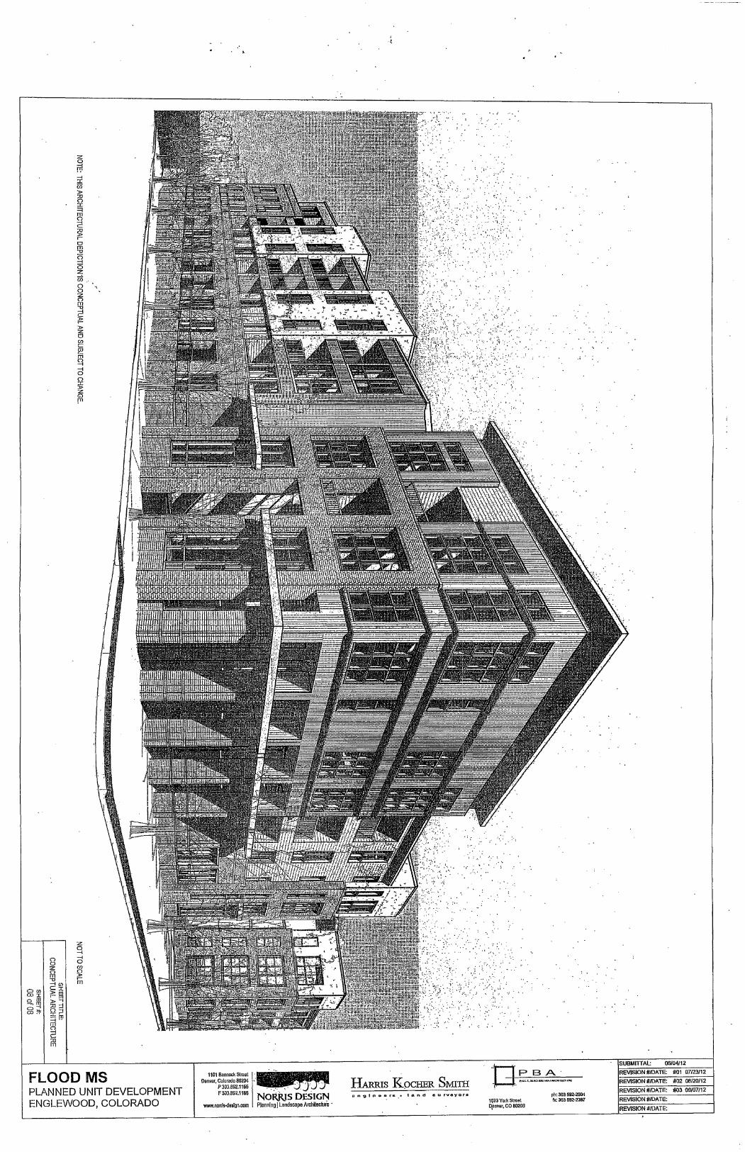
8 I om~~~ co:c >m om r m 2;!!1 55~ co~ c-:>=i :cr
=Jfll m (") -1 c: :;u m
z 0
r:l :t en )>
~ ;=;j
~ ~ .-0 m -u
~ 0 :z; en 0 0
5 m ~
~ )> z 0 en c ~
~ a (")
§; ~ rn
z 0 -1
a Cl) (") )> .-m
FLOOD MS PLANNED UNIT DEVELOPMENT ENGLEWOOD, COLORADO
1101 Bannock Slreel Denver, Colorado 80204
p 303.892.1166 Fil03.892,1186
www.norri&<leslgn.com
~ Noi_RJ~. DeiiGN Planning I Landscape Architecture ·
·~
.··?·.
:I:
··-·
. ~:
. · .. · .·:;
".':.·· .~·. •' • ,I
HA.ruus KoCHER SivliTH on gIn e e rs .• Ian d s u rveyars
. •'
··. <~·
·.,;··
·: .. ;.::::·;';'
;-· .
PBA 1'/IIII.T,DIIIGII,I\I...V.IMPilrJ:al'll'e
W33Yori<Stroel qenver, co 80206
ph: 303 592-2904 rx: 303 592-2387
SUBMITTAL: 06/04/12
REVISION#JOATE: #01 07/23/12
REVISION #IOATE: #02 08/20/12
REVISION#/DATE: #03 09/07/12
REVISION#JOATE:
REVISION #/DATE:

I ;;;;;;, I
"' <)
·w
~ g 2!
! :-!,
ALTA I ACSM LAND TITLE SURVEY
.. ,, •
., ·~ ·~ ·g "' t= !:> 0 !"
. u.s. HtGHWA't .285
. I
1
i
i !
j ··g "' ·::I
i!O ~ "'
VICINITY MAP
LEGEND
tNOICAlES.lOT mlt .BOOtlDMY.
Po*.."!CE!.1W. ;on .. QJ..-1-f7 .. !37..t:
"~O:uo. ~.0'17 .. 0J-.T-"W-012.
.,..-'ooi'CIJ)D 1/Z' PIN
P/.!la.t.·t~:o ~!177 .. 03-J .. liJ'"~ ~·
I L-------' L_ ___ ___;{ OC.' !t,':: L_ ___ __J L_ ___ __j ·fi," Fi/n ,-rFOUJlD t.,·P.'.H
EAST tEHIGH AVENUE
CONTROL DETAIL
.CQL0Rt\.DO ENGINEERING & SURVE'liNG INC ••
NOTES :rn~· tL~u~~M o'f~~.O~~ s~~/iJs'M.fc\~rfticgo~ ~R~rccroEgL~r ~E CU.RK AND RECORDER IN lliE.'CCUNTY ·OF ~.RAPAHOE ON :tHE JRD 0/,y ·or ~.PRIL. '1917 •.
2·) ~~u~oWot'.ffiT'~RM~s k1aP~J0u~l~'li?R~~~~~to~f~CtJl~M' BE V!:RIRF.:D PRIOR TO ~NY OI~Gi~G OR CONSTRUCTION.
3,) COLORADO STATE LAY/ CllS S-1.5-101 STATES lliAT EV!:RYONE PLANNING 10 DIG IN
-~~~~~M ~~~~~ :~g~~c~W~~Tc~'W·~~~6L8kA'o~~F0~~~Llr~~~~12\0 BUSI~ESS DAYS BEFORE YOU DIG - CAL!. 1-aoo-~22-1987 OR .534-1;700 IN Mtn'liO DEN\1>R lO LOCAlE BURIED LINES. .
4.) A!.!. kEARt~CS AHO DISTANCES SHO\\'N Altl!; 1\ClVAL. I.!EASUREMENTS UNU.SS OlliiRWISt NOTED.
5.) 1111JSURV£Y·DOES NOT CoNS11'w.JE A 11Tu. $EI>,RCH ll'(COLORA)>Q EflGiljEERJliG AND SURfEYING, INC. TO 'OE'!EI1J:IiNE OWNERSHIP 1\NO EASEIM:NTS OF R£CDRD. FOR;ALI. INFORMATION REGARDING !ASF.MEr41S, RIGHT-01'-\VAY MJD TITLE OF RECORO \Ill: ·nEUED UPON Till£ COMJ.IITUf.ilT NO. 14112108 •
aJcTive DATE! JUNE .00~, 2~11 AT 7<30 A.~l. BY< I ·CHfcA.GO miE or cOLoRI\DO, ooc.
S.) . 0~frS;'ot5R~=N~NfH~s~c\!sEFlJR'h/'t~~ lllb~F'J~~8{ A WARRANTY OR <lU~RANlEE, EXPRESSED '!JR JI.IPUED.
8.) _AccPRDlNG :ro COLORADO ).AYI '\'PIJ MUST COMMENCE -LEGAL :AC'!ION 9ASED .UPON AllY . .llEI'ECT IN THIS SURI<Ff mn~N lliREE 'tEARS ~.FTER YOU DISCOVER Sll~ DEFECl',
. lN NO EVENT. MA 'I' Ml'l' ACTIDI'l B~SED UPON A .OEFECT IN 1HIS 5\lRVEY BE. COMMENCED !lOR~ lliAN ro-1 YEARS FROM THE CER11f!I:ATiOR SliOWII ·HERF..ON,. . .. . .
9.) 'THclE.ARE 17 PAINTED (SlroPED) PAP.KING .SPAcES .. ON SUB.'ECT PROP£RT'(, NONE Of 1\tliCH ARE DESIGNATED AS 'HANDICAP P.ARK1NG SPACES:
1 0.) i.iNE~ MEAS~r<£M£1i1'S SI:!PIIN !IND STAT!;Il H.EREON A~ IN u. S. SUf<'ltY tttT.
11.) 'iRE[~ORlllERL.Y AND SOU111E~tY RIGHT OF Y(AY LINE.~ FOf!. E. I(EIIYON AVE •
·~gm:~~~S~~ ~~J~~YS!Jt~~:~~~DOVIH Of EJIIS'I}NG SUR\'EY COtlTRO~
12.)
MAPS ARE DATED DECEMBER i71Ji., .2010 ·COMMUNITY No. 085fJ74 PI\NU N9. 018:lK . ZONE: ·"X"
...
Tq: NOi::IJRWR~foNo~t~AP.fflQE. ·~t,~ ·QJ' CO!.OR.ADo,
COLORADO,. INC.
THIS IS TO CERJIF:f n·IAT 'll-JIS MAP OR PLAT AND l'HE SURVEY ON .V.'fiiCii IT IS BASEO WERE MAD~ IN ACCORli.iiNCE .YMH THO: 2011 MiNIIdUtJ STJ\NaARD DETAIL REQUIREiiiENTS.FO.'! ALTA;i'ACSM WID. mu; SLIRliEYS," JO!N.7LY ESTAiiU!!i'I!;IJ ANQ ADOPTED 9'1' .~LTA AND HSPS, AND lll!lL\JOES ln:MS.1,.:2, 3, ~~ .7(o), S, '9, 11(-o), AND Ui OF TABLE: A 11-t£REOF'. :n1~ F1EL0 WORK WAS COMPLE!:ED o~ JUNE 281M, 201J ..
(SEAL)
3470 SO. SHERMAN S'l.'t #2, ENGLEWOOD. ·coLORADO 801.13
' (303}-7e:L-a055
~
PART OF SHEET 1 OF 2
THE NORTHEAST 114 OF SECTION 3, TOWNSHIP 5 SOUTfi RANGE 68 ·W£87;
OFTHE6TH. P.M BEING ALSO A PART OF
BLOCKS 1 AND 4 HIGGINS BROAOWA Y ADDITION,
COUNTY OF ARAPAHOE, STATE. OF COLORADO
LEGAL DESCRIPTION PER liRE COMMI'IMENT MO. 1482108. ~SEE NOTE .NO. SlJ
~
l01S J3 '!!i?.OUGH 19, }~CLVSl\'E, At!O :Z~ '!JlBOUGH Je, I~!J,USI\'!', BLOCK 1, .H!GCI~S BP.OAili'IA:t ADill110ll, CC\JIIn'·OF ;t.flAPJ..HtE1 "SU\1£ Cf" COlgR,;DO
PARCEL f1l.
L01S 20 '!li~CUGI! '5, BLOGK-1, HIGGINS BROADWAY ADDinC!I, COUNlY Of" AR.O.l'I\HOF., STATE OF CO',ORADO •
~ J.D'!S 10. ~~ PND 12, OLOCK 11 ~!GGUIS BROt.QW4~ .AODiliDN, COUIITY OF ARAPAlillf;; )iTAli OF C_Q\.Pi!l\00.
PAilCEL 'D<
J.OlS. 6 TtiRCUGi! 9, INCUJs!'IF., AllD ':19 11iROiJCH ·5D.INCUJSJ\ii:, 5l:OCK 1, fliGGitiS :!lllOJiD WAY A)>DmON, .COIJN)'Y Of ARAPAiiOE, STAiE .OF CO'~O!WJO.
EXCEPT '1\lAT PORTION CliNiit'rED 10 ·'IH£: CITY OF ~GU!\YOD~ it! DEID 'RECORDED JANUARY 2~. 1058 !N .DDOK e~2 ·AT PAGE 79'..!JlD)li~T.PORnoil CO~'/EY£0. TP:lliE .STATO'OEP~RTJ.IEMT lilCHWArS, DIVl!:r.dN .OF I.UOtiWA'i'S,·STATE'Q; OO!.ORAD9 m DEliO RECOODE!) ,IULV. 21, 1970 Ill SQOK 1975. AT PAGE 110.
~ 111;: ·AIJEniAY IN BLOCK i ~JOINING LOIS :6 'THROUGH +5. JNCWSIVE,, tiJGG(KS eROADYIA.Y ADOil!Oll, ·As S~OI\!( o
0N, 1HI!
f!'.Ai'''THEREOF RECORDED APRIL 3, 1917 UNIIE!l RllCill'llON NO. +.!923, CCUfm' ill' ARAPAHO:', f;TA'ij: OF QOLqAA ~· _
!.OJ JO AND m~ SDUUi ONE HALF. 'OF .tOT ll, ·1iL0tX ?, HIG!liiJS B~OAOWAY ~Ooillott CCui:ln" QF 1\li.<J>f:!tOE, 9To\1E ·cr o.OLO~ADo, · ·
CA&.U: . . • L~l'$' 1.7 ~li!O· -1~. B\.0~ 2, .HIGC!N~ ;a~p.AQ>IA~ P:opiTI\i'i •. -cQ~Im' OF MUPiii!Ott, STA'rE OF etltORJ.lla.
PAACEL ~
:lW~A~J:-E NORTri ONE HALl' OF LOT 20, B~OCK <. JliGCINS BROADWAY AODilJON1 COUN1Y or ARAPNiOE:, STATE ! .
.PARCEL &
'll!E NO.~~ DtlE Hlii.F .OF !.0131 AND All. or (QT. 321 13LC<:K 2, HIGGitiS BROADt/AY 1\llDlliDN, CCUNlY Of llllAI'illlci£. STATE Of COLCf!ADO,
,?>RCEL ~
~OTS z.::ANO 25, BLOCK 2, HIGGINS ·Bi!Oi\DWAY. ADDITION, toUUTY OF ARAPAHO<, STATE OF COLORADO.
PARC<L X.
TH!: SOUJH O.~E HAt~ OF LQT 20 NlD .~ll OF lOT 21, BLOCK 2, tRGGl!-IS. BROAOWAY ADD!iiON; • .ccuNTY OF ARAPAHOE. ST)(1E· CF COlOilADO. . 1
P,\RCE!.~ . I .. Ul!>. 2ir:~Nil 29, SLOI:!<:i.j~IGGI!IS''B~OAP'IIA'{ ADRilJON. CPUNTY Of. ARAl'.i\HOE, .STATE QF· CQ\.OR{\!JQ.
P.ARCEL j, . l . LOTS 33:34 ·AND 35. Bl, .2. HIGO!t~ 8ROI\OIVAY :i.O~InOtl, COOifi:Y Of AilA!'AiiCE. STA1E·ll1' ·GC~ORI\00..
PN!CEI. H! I
PARCR!, ll:. •
LOTS )2 'l\Ho 2:1, m.pr.K 2, IMGI!!S·SROAAWAY .\DDJ1lOW, :COUNTY or AR:O.PAiiOE. 'ST~lE: OF etli..Orti\DO.
~ LOTS \5 I<ND 16, BLOCK 2, G~tiS S~OAQ\'IAY AQDJ110N, t;QUN)l' OF ARAPAHO£, STATE OF COLORADO •
1:01S.2&:~D 27, BLOCK ~[lt:1li~S.BI!OADWAi' ADDl!ION, CO~NIY OF foJlAP~iJOE, STAJE CIF CQLCRAOO,
I!XW'T t~IIT'PCRllON' CON[' ·- 10 :JHr. aTY OF'ENGI.-"1\'0QD BY pEED RECORDED OCTOBE:R 21, !96~ IH BOQI< 1554 ~T. Pf\llE~9\'- . •
PAIICEL ll: . ,
l}IE 6Wi.fWAY IN BLOCK 2l4D.IDINI~G· LOTS 15 THROIION 35, INCWSIVE, HICGINS BROADWAY APDI'!IOI-1, EXW'T THAT PDRT!Oil Cf" ,WEST HAI.F' OFlt.i.J.EY 'ADJACENT 'TO LOTS· ,15 AND 16 CON'IEY"t:.D TO TriE: CITY OF .EtlG!.f:'I>WD BY DEEP RECORDED ~C!CilER. 21, 10r IN BOOK 1554 AT PAGE 390 •
. . I PROPERTY ADDRESS: j
~650 SOUTM EROADll'bY -.ARAPAHO!:: COUNTY PARCEL. J.D. 1/207.7-:-.0~:-1-08-004, . 3690 SOUTH UtJCCLNj'S'mEET- IJW'AHOE .CC.UilTY ~ARCEL LO •. W2077-03-I-D9-00S
WTJ.L ~REA OF SllB.ECT ·~ROPERlY !5 2,pC1,693 ~UARO: ·FEET OR 4.~073 ACRO:S. ! . ~ ~
Rf:VlSID Z-2~2D.12 fOR CITY 011CCI & EASE!I.EN! CES :2011-1.:584
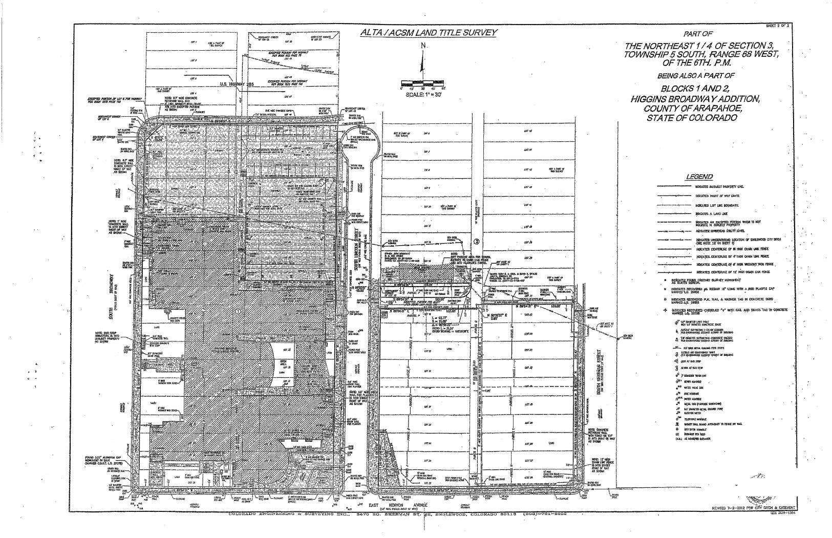
St;rJ ..... T t:F'l.DTf
~ ~ ~~ "l-i:s ~ ., fi
'" iEE. -~
jf 'lw
r-·----·--·--~---·---1
Ulf: ~~t~f.r«' i i---··-··-·--·--·--~-·-·----l
J.(JfJ
·Jo.Vt'J.J.l il~.~'( .....
c:oLOH.A.DO .ENGINEEl~l.N(..:Y & SURVEY.I:NG L."'iC ....
ALTA ./ACSM LAND TITLE SURVEY
N
~ la ;;; I o• ·15' 3a -~~· eO'
S:C.ALE: 1" = 30'
.nnr;;i•JJlf« JI~:!U't\1'J
/016
:all
w,.
"'" 1.7"
ICI/1 JrfJt Ai!}JII Q( 4 :'!;K'l.$1R~'£? @?
~~ ~-\'!
wu
..... J!)f'f(!
tDt"
tfli:t
~I:!
'"'""'
rr.r;4.
EAST KENYOr4 A VENUE (!a' l'GltPiSUCF.tthiClt W~'t)
34.-7'0
UJT-15
Uf'r-+1
l<14J t!Cf.I..PA!tl'r.Jl MSSI£"~
UJTft
't;JT.ft
."J.tJi~
·r#r.h
lal;;tp
'Uir45
.. ~..,.,.
tnr.:rt
l.OTJ?
f.PT..l!J
1.4Tlt
J.tJr,J# 1;.1-W.I
~ra
(:.S03)-7-6J.-8055
SHEET 2 OF" .2
PART OF
THE NORTHEAST 1 I 4 OF SECTION 3, TOWNSH!P5SOUTii RANGE-68 WES.T,
OF TH£:6TH. .P.M BEING ALSO A PART .OF
BLOCKS "1 AND 2, HIGGINS BROADWAY ADD/nON,
COUNTY pF ARAPAHO~ STATE OF COLORADO
LEGEND
,.._...._-:--+.--"-- .it'lDIC;tES LOT Lma aocproARl'.
~lDICA'il$ /1. I.Atlb 1.NE
JllDICATES AM El!C!Ptm f'iiR~Dil 1\\tlCil "IS NOT INI;WQEt). I~ SPI4EC.f PRJil'[lllY . .
.IJ;DiCAtES:O'J!IIittA!> untirr .UIIEl!.
-~~~~~~~SJ~~ ~1100 01" EHGI.E'HOCD OT'IlliTC!i
lllQICATES ~1611J~E Of a! HIGH DI"''N UIIIC .~"c£
!lllt~AjtS. Cl!llreRUill! DF .V ~UC11 CllAIN llllK ltNct
~-.....,...,.._ INDicATES CEljJ<!IUII~.Of fllilllll 'M!CIUJii!T)llOI! FEtlc.! •
llllllcl."f&ll c:an;JilJJIE OF 11' t<ian Cll.<!l< Util( Wet
.!t'el~lffo~~~o.~!"""IIG S<JA>£"( lo!PHU~Eiif
o INDICA"r.S RECOVERED 1!5 Rl!SAA Ia" "LONG .\11TH A .R£Q PL.~S1JC C-'1' MARl< ED "I..S. 26958 •
0 INlliCA"r.$ RECOVERED P,K. >J.<Jt. U. WAS>IER TAG IN CONOlElE CURll t.IAR.KED .1~ •. 26~
1- w~lESc:o~;w ·<;I:!J~ ·"+" Wtljl NAiL ~~p ~RASS "'rAO "iN ·CQNC"-0.
:Ji:"! -~~~~~~~&~£ ,at.SE
:r .DJ/io.JtSJFPCiillltJI-P.:EIU'~ 111. .nlR D_YERIWI'JI!i>; so:c:w> ~DR'r tf flEI.OIIJt.
• 'fD.' DIA&L."t'EH SliPP.iA.ma CONC9£It toLtiuil U:: 'Ftul·Li'."EIIH..t.f.~'!aXifiO .smR't Cf'.EU!!UI(IC
_$.._ -~-~~em.~WC.fpftst'EPS
~ .-~f.t~~~~tF~I(G ~~ $II AT BOI'.Sltl'
:s ·"""'AT"""""!"' ·"?'"""""""""'IIi Q!~u Gtre UANIW:
.,.we· WA'ttlt VAL~ liOl
il.IH llll'C'.rmRUlT
.o.wm. A'liH MANHOlE
• 111 \L.7AL DOX {PWliO$£ Ut,niO'Ili)
P JU' D"-lcr!!R·kf;T~ CUM'n f10Sf Jll. ELC'tTIUC l.ctm
0~ 'JU£P/10it UAiiilot£
.!£ a.w.tT BIA NAl'ID "1TAQI£tl' m FDJC£ CW 1Qll.
0 crrt'Dttlllll.liitx.J:
tO) OISJJ.ilc:t PDI bEEO (A.\c.) o\S.IWSI.'Rm cUT~.
"{~!~~-t;~~~- ,: RE'IlSEO 7-2-2012 fOR CITV f.liTCH &. E.;>cli.ENT

..
, t
·.
...
PRELIMINARY SUBDIVISION PLAT
ALTA CHC./?.1? Y H/.L.LS Sl1.8.0/J77S/OJV S/T{,!A T..f.O /H TH£' HO.I?TH£'AST Q[/A./?T£'.1? OF S£'CT/OJV 4' TO WHSH/.P 5
. SVOT.Ii .M.!VO£' 6'8 W.£'S'TOFTH.£' 6'TH .P./?/HC/PA.l.MS.I?/..0/A!l{ . CITY OF .£'1fO.l£'W00.4 CX:Jl/1f'Y OF A.IU.PAHO£; STAT.£' OF CO.lO.IU..OO.
,.
l ~
DEDICATION kNOWN ALL MEN BY THESE PRESENTS: THAT THE UNDERSIGNED WARRANTS THAT IT IS THE OWNER OF A PARca OF LAND LOCATED IN THE OF SECTJON 3, TO,.,.,SHIP 5 SOUTH, RANGE 58 wtST OF THE STH P.M.. ALSO BEING PART OF CITY OF ENGLEWOOD, COUNTY OF ARAPAHOE, STATE OF COLORADO, MORE PARTICULARLY DESCRII!ED AS FOLLOWS: LOTS 13 THROUGH 19, INCLUSIVE AND 2S THROUGH 38, INCLUSIVE. BLOCk I, HJCGINS BROADWAY ADD In ON, COUNTY OF ARAPAHOE, STATE OF COLORADO: AND LOTS 20 THROUGH 25, BLOCk I. HIGGINS BROADWAY ADDJnON, COUNTY OF ARAPAHOE, STATE OF COLORADO: AND LOTS 10,11 AND 12, BLOCK I, HIGGINS BROADWAY ADDITION, COUNTY OF ARAPAHOE, STATE Of' COLORADO: AND • LOTS 6 THROUGH 9, INCLUSIVE AND 39 THROUGH ~0, INCLUSIVE, BLDCk·l, HIGGINS BROADWAY ADDinON, COUNTY OF ARAPAHOE, STATE Of' COLORADO, •
EXCEPT THAT PORTION CONVEYED TO THE CITY OF ENGLEWOOD IN DEED RECORDED JANUARY 2~, 195S IN ~~O~~J,~~A:J. ~~~iE:7~FAND THAT PORTION CONVEYED TO THE STATE DEPAR)I.IENT HIGHWJ,YS, 01\llSION
COLORADO IN DEED RECORDED JULY 21,1970 IN BOOK 1875 AT PAGE tlq. TOGEniER \liTH ' .
LOT 30 AND THE SOUTH ONE HALf' OF LOT Jl, BLOCK 2, HIGGINS BROADWAY ADDITION, COUNTY OF ARAPAHOE, STATE Of' COLORADO: AND . LOTS 17 AND IS, BLOCK :Z. .HIGGINS BROADWAY AD011JON,
. . . . .. ..... _ .... __ ·----·-·-,,.----·------,,--.,------:-J--·-----------,------.,--...,.--'------·--·-··-.. --- COUNTY OF ARAPAHOE. STAT£ Of' COLORADO: AND .. _ ··-· """LOT'19"AND'"IHE"NORTH'ONE AAirOF'LDT'20, BLDCK 2, HIGGINS BROADWAY ADDITION,
i ,, .:i.
··.
:--;·~------ ,.B£'11'~
... . ~ '"' ~ i
NGS BRASS DISK fiv 4ll9 IN 'lliE ABUlMENT OF SOUTH ~·. uJ
. ··t.
BROADWAY. BRIDGE AT HAMPDEN AVENUE, • ill.VATI,ON=53:4:~~ NAVO ~a, .·· ....
. -NOTE: El<ISTING CONTOUR INFORMA1JON SHOWN HEREoN ' WAS PROVIDED BY THE CITY OF'ENGLEWOOD. CONTOUR ELEVATIONS SHOWN DO NOT MATCH' ELEVA110NS ESTABUSHED USING THE ABOVE BENCHMARK. DATUM ANO BENCHMARI<S UTIUZ£0 FOR EXISTING CONTOURS ARE. UNKNOWN. ;> , •
.BAsYS OF .o£Air/JVOS . . BEARINGS ARE BASED: ON 'iHE WEST -LINE OF THE NORlHWEST QUARTER OF THE NOR'JH[AST QUARTER OF SECTION 3, TOwNSHIP 5 SOUTH, RANGE 68 WEST OF THE 6TH PRINCIPAL MERIDIAN, ASSUMED. TO a~ NOR'fl'l 00'31'50" EAST. . ' . . ·, • .
F.£00]) C£'RT/F/CA T/OJV I HERe:8Y CERTIFY THAT THE PROPERTY DESCRIBED HEREON iU!lli LOCATED IN A 100 YEAR FLOOD PLAIN, ACCORDING 10 THE MOST CURRENT FLOOD INSURANCE RATE MAP (FIRM), PRODUCED BY THE: FEDERAL EMERGENCY· MANAGEMENT .. AGENCY· (FEMA).· •
MAPS ARE DAlEO oEcrnafs 17 2Q]Q COMMUNITY NO. ~ PANEL NO, ~
---- INDICATES SUBJECT PROPERTY l:lHC AS SHOW/f.
---- IHDICA"l£5 RIGllT OF WAf LIMITS.
---- INDICATES LOT LIHE SOUHDARY,
---- INDICATES OFFSET LINE AS STATED.
--·-- INDICAlES CEHTERUNE OF R.O.W. AS SHO\IJN.
--·-- INDICATES I. LAND UHE AS ST:'TUI HEREON.
---------- INDICATES EASEMENT UNE..
·.· \ W.MAHSFfei.nAVE
SJ:4.tYJ)AHlJ JV07'£'S 1: DATE OF FIELD WORK: JUNE 28, 2011
:Z. THIS PLAT REPRESENTS A BOUNDARY SURVEY OF THE PARCEL SH"""'. IT IS PART OF. A SUBDI\IISION PLAT OF "HIGGINS BROADWAY ADDITION• FIUED WITH THE CLERK AND RECORDER OF ARAPAHOE COUNTY ON THE 3RD OAY OF APRIL, 1917 A.D. RECORDED IN PI.AT BOOK ~. PAGE 23, RECEPTION NO, 44923.
3. .ACCORDING .TO COLORADO LAY/ YOU MUST. COMMENCE LEGAL AC1JON. BASED UP.ON ANY .. DEFECT IN THIS SURVEY \\llHIN THREE YEARS AFTER YOU FIRST DISCOVER SUCH OEF£CT. IN NO EVENT, MAY ANY ACTION BASED UPON ANY DEFECT IN THIS SURVET BE • COMMENCED MORE THAN 1£N YEARS FROM THE DATE Of' THE CERTIFICATION SHOWN HEREON,·
.4, COLORADO STATE LAW CRS S-1.5-101 STATES THAT ANYONE PLANNING 10 DIG IN OR NEAR A PUBLIC ROAD, STREET, ALLEY, RIGHT-OF-WAY, OR UTIUTY EASEMENT IS TO NOTIFY THE U1JLITY NOTIFICATION CENTER OF COLORADO OF YOUR INTENT, THREE (3) BUSINESS DAYS BEFORE YOU DIG. CALL 811 OR 303-534-6700 IN THE METRO DENVER AREA TO LOCATE BURIED UNES. ' . ' . . '
S. THE UNEAR UNITs FOR THIS PLAT ARE: U.S, SURvEY FEET.
6, THIS SURVEY DOES NOT CONSTITUTE A 11TLE SEARCH BY HARRIS KOCHER SMITH TO DE'!ERMINE OWNERSHIP OR EA5EMENTS OF RECORD. f'OR ALL INf'ORMATlON REGARDING EASEMENTS, RIGHTS-OF-WAY AND TITLE OF RECORD, HARRIS 'KOCHER SMITH REUED UPON COMMITMENT FOR TITLE. INSURANCE, COMMITMENT NO. NCS-542989-HOUI ISSUED BY FIRST AMERICAN TlllE INSURANCE COMPANY AND HA\11NG AN EFFEC11VE DATE OF' MAY 1, 2012 AT 5:00 P.M.
7. MINIMUM EIGHT-FOOT (B') WIDE DRY UTIUTY EASEMENTS ARE HEREBY DEDICATED AS SHOWN HEREON. THESE EASEMENTS ARE DEDICATED TO THE CITY OF ENGLEWOOD FOR
~ ~ I:i.Tn~~JE?~~ER~~~~~~ ~~6f.~~0~. ~~~oW.s~~~~"..':lc •
a i ~~~~~~'Wi~11~~~ ?c~E~M.~:-'N~'i>~~~rV ~~~~ rWE~:.f~s~~~--·---- IHDICA1ES BOUNDARY OF Ni EXctP1tD PORnON,
! ii. -0 FOLmD com:. NAtt. \';'llJ-I BRASS TAG PLS :ZSSSS 1H CHlS£lED CRQSS PERMANENT S'IRUClURES, IMPROVEMENTS, OBJECTS, BUILDINGS, WELLS, WATER METERS _. AND OlHER OBJECTS THAT MAY INTERFERE Willi lliE UTIUTY FACIUTIES OR USE lHEROF
.;
. \
·'. . ...... : W. NAssAU AVE
,.: - : -· .. · ~CINITY MAP
,;:sCALE: r ~ sao· -~
Sheet·lbdex COVER SHEET
:>t SITE~ ~EXJSTING & PROPOSED CONDITIONS
3 SITE PLAN'·EXISTING CONDmoN' '
. ~ sire PLAAJ PROPOSED CONDiTION
!;
LAND 'PLANNER:
~ NGR,NS DESIGN PlaM.hll)landscapa Artnl\acbJre
1101 Banno:lc St.al Demcr, Colrredo 80204
. P303.B92.1166 F303.892.1186
\IMW.no:ri!-desfgn.IXIrrt
CIVIL ENGINEER:
HARRIS KocHER SMrni ~ ~ ~ :::: :N:: :: : :R:C T:P:LS 2::::8 ~JE~~~Gp~~~~. s:SA~~~~~. ~~~~~:~wy ~~~~~~~z ~~~~~T Pfjg ~:: COST TO SUQi GRANlEES, INCLUDING WITHOUT LIMITAllON, VC:Gt:rAnON. PUBUC SERVICE u n .9 I n o o r a • I a. n d. a u.r v a '1 o.r s
t;
! .;
-
W. MAN.~ EI.D AVE
l
SURVEYORSC£'RTJFJCA TJON ' I, AARON MURPHY,A REGISTERED LAND SURVEYOR IN THE STAll: OF COLORADO
DO HEREBY C£RnFY THAT 1HE SURVEY OF THE AI IA <:HERRY HI! Is SIIBQ!YISJO!i WAS MADE BY ME OR DIRECTLY UNDER MY SUPERVISION AND THAT THE ACCOMPANYING MAP ACCURATELY AND PROPERLY SH~ytS THE SU,RVET THEREOF,
AARON MURPHY FOR AND ON BEHALF OF HARRIS KOCHER SMITH 1391 SPEER BLVO, SUITE 390 DENVER, CO 80204
UCENSE NUMBER 3B152 DATE SIGNED
.,
COUNTY OF ARAPAHOE, STATE OF COLDRAOO; AND • THE NORTH ONE HALF OF LOT 31 AND ALL OF LOT 32, BLOCK 2, HIGGINS BROADWAY ADDITION, COUNTY OF ARAPAHOE, STATE OF COLORADO: AND • • LOTS 24 AND 2S, BLDCK :Z. HIGGII4S BROADWAY ADDITION, • • . COUNT'I' OF' ARAPAHOE. STATE OF COLORADOi AND THE SOUTH ONE HALf' OF LOT 20 AND ALL OF LOT 21, BLOCK 2, HIGGINS BROADWAY ADDITION, COUNlY OF ARAPAHOE', STAlE OF COLORADO; AND LOTS 2B AND 29, BLOCK 2, HIGGINS BROADV/AY AOOillON, COUNTY OF ARAPAHOE, STAiE OF COLORADO: AND LOTS 33, 34 AND 35, BLOCK 2, HtGGINS BROADWAY ADDITION, COUNTY OF ARAPAHOE. STATE OF' COLORADO; AND LOTS 26 AND 2.7, BLOC!< 2, HIGGINS BROADWAY ADDITION, COUNT)' OF ARAPAHOE, STATE OF COLORADO; AND LOTS 22 AND 23, BLOCK :Z. HIGGINS BROADWAY ADD11JON, COUNTY OF ARAPAHOE, STATE OF COLORADO: AND LOTS 15 AND 16, BLOCk 2, HIGGINS BROADWAY ADDI1JON, COUNTY OF ARAPAHOE, STATE OF COLORADO,
EXCS'T THAT PORTION CONVEYED .TO THE CITY OF ENGLEWOOD BY DEED RECORDeD OCTOBm 21, 1964 IN BOOK 1554 AT PAGE 390. • . • • "
CONTAINING A TOTAL Airc.A OF 158,804. SOUME FEET ?i1 .;.sS A~ES. THE UNDERSIGNED OWNER HAS .BY THESE PRESENTS LAID OUT, PLATTED AND SUBDIVIDED THE SAME INTO LOTS AS SHOWN ON ·THIS PLAT UNDER THE •. ' • • NAME AND STYLE OF "AI 1'A CHERRY HillS 5!lB0!\1!51PN''. AND DOES HEREBY OEDICAiE TO THE PUBUC ALI.'RIGHT-OF-WAYS AND EASEIIDITS FOR' THE: PURPOSES SHOWN' • HEREON, . ' •, ' ·... • ' • ·.•
El<ECUTED THIS'-·-___ DAY OF :--'--~---''· A.D. '20_
· sTATE or coLORADO
COUNTY OF ARAP~HOE }s.
:E FOREGOING IN~R:CM~TB~~S ACkf'!O\\I.EDGED' BEF~:~~ THIS_.DAY
FOR SCHOO!- DISTRICT ND:'i, A. OUASI-MUN}CIPAL ~O~ORAiiD'N. ' ~ITN£?5 MY HAND AND SEAl
MY COMMISSION EXPIRES: . . NOTARY PUBUC
ADDRESS APPROVALS
RECOMMENDED FOR ·APPROVAL BY iHE CITY OF ENGLEWODii PIJiNNING AND ZOHING COMMISSION . . " ' . . ' .. ··:. .
ATTEST:
RECORDING SECRETARY OF THE PLANNING .AND ZONING COMMISSION
DATE •
APPROVED BY THE CITY COUNCIL BY ORDINANCE ND. ____ ,, SERI~ OF 20_,
MA "'"'Y"'a"'!II"""OF""'T."''Hli!i;:--.C:;:;~T;;,Y;";;OF"'"'B"'~;,;G;.,;!.B';;J;;ro::::o"'Di-...:..."'-...:...,...::....:...,;:;"·c:,· ...:·.::."..:.·:.· ~ ~~~ •• .'
ATTEST:
C17'Y CLERK DATE
CLERK AND R£CORDSC£R7'/FICATION ACCEPTED FOR FILING IN THE Of'FICE OF THE CLERK ,AND RECORDER OF ARAPAHOE
COUNTY, STATE OF COLORADO. AT __ D'CLOCk _.M., ON THIS ___ DAY OF
' · """;A;C.,"2D=:;· 'RECEPTION"NO:._ .. ____ • BOOK NO.----
PAGE NO(S). ____ ~
BY: BY: CLERK AND RECORDER DEPUTY
ALTA CH£.1?1? l'lff.LLS SC.BJJ.I'f/7S/O.!V 3650 S BROADWAY & ~600 S L!NCOL!I! ST
SITUATED IN THE NORTHEAST QUARTER OF SECTION 3, TO'IYNSHIP SOUTH, RANGE 68 YIEST OF THE 6TH PRINCIPAL MERIDIAN,
CITY O:F ENGLEWOOD, COUNTY OF .ARAPAHOE, STATE O:F. COLORADO. f.i • SET ~xH' REBAR V¥1lH m.ue: PI.ASJlC cAP PLS 38152 ~g~~NN~~~~l:f5° ~~011cf'p,~~B~1ss~~5p~~~E'J-ri!E5~Th "WJ-~~ ~~c~E~IR£ 1391 Speer Blvd •• Sulte 390 COVER SHEET ?~3 EAsEMENT ON ITS STANDARD fORM. Denver. Colcrndo.80204
j~L--------------------------------------------------------------------------------------------------------------------------------P-~-~-~~(_J~-~~f-~_~_i~-~-~-~~-·----------~----------------------------------------~S~H~E~ET~ __ J1UL ____ ~--~--------~--------------------------------------------J
,. ·.:.l
~ . . . .

,,
30 30 60
SCAlE: 1'=30'
PRELIMINARY S_UBDIVISION PLAT
' '
ltlf#
ii;t,_ __
·'
""·· ....
\
/'-____ ,. IDT?-,
·-..
IOT·U
IDT-17
101-fl
EXISTING ZONING: MU·R·38
USE: MIXED RESIDENTIAL
' .... ' ......... ... '
\ \
\
........ .
..... -, / \ \
/ I \ I \ I \ I \ \
\
'
5346
\ \ \ \
'\ \
\
I
'\ '\
'
/ /
/
I
I
--
.... ' ..... _
t:!Qre.. I. All EXISnNG WA 1ER .AND SANITARY
SEWER TAPS THAT WilL BE ABANDONED SHAll BE ltlli.IINATED AT THE CITY MAIN •
A.tTA CHEJ?J?Y Jl7.t.LS SU.B.DJY.!SYOir 3650 S BROADWAY & 3800 S LINCOLN ST
SITE PLAN EXISTING & PROPOSED CONDITIONS
SITUATED JN THE NORTHEAST QUARTER OF SECTJON 3, TOWNSHIP 5 SOUTH. RANGE. 68 WEST OF THE 6TH PRJNCIPAL MERIDJAN,
CITY OF .ENGLEWOOD, COUNTY OF AR,\PAHOE, S'I'ATE OF COLORADO.

>· ·•
·''
\
\
I y ,, l I
. \ I I I I
30 60
SCALE: 1"=30'
PRELIMINARY SUBDIVISION PLAT
---lDI6
USE: MIXED r: RESIDENTIAL 0 34o _ ""'
\
-liJfiU
/', ____ , l~f.i).,
'
fCII.JI
lDI J.~
--------
""04 EXISTING ZONING:
'"'" R·2·B USE: VACANT
/ /
....
\ \
' \ \ I I \
\
' ' \ \ \ \
\ \
\ \ \
\ \
\
\ I \ l \ I
\.I \
\\ \
\ ' \ \ .'-. .
\ ', I \ " -' \
\
" \ \
--- 534G --
-AlTA C.!:I£.1?./?Y .J//.L.lS SuBJJ/V/S./0./V :1650 S BROADWAY & 3800 S LINCOLN ST
SlTllATED IN THE NORTHEAST QUARTER OF SECTION 3, TOWNSHIP 5 SOUTH, RANGE 66 1'/EST OF THE 6TH PRINCIPAL MERrD!AN,
CITY OF ENGLEWOOD, COUNTY OF ARAPAKOE, STATE OF COLORADO.
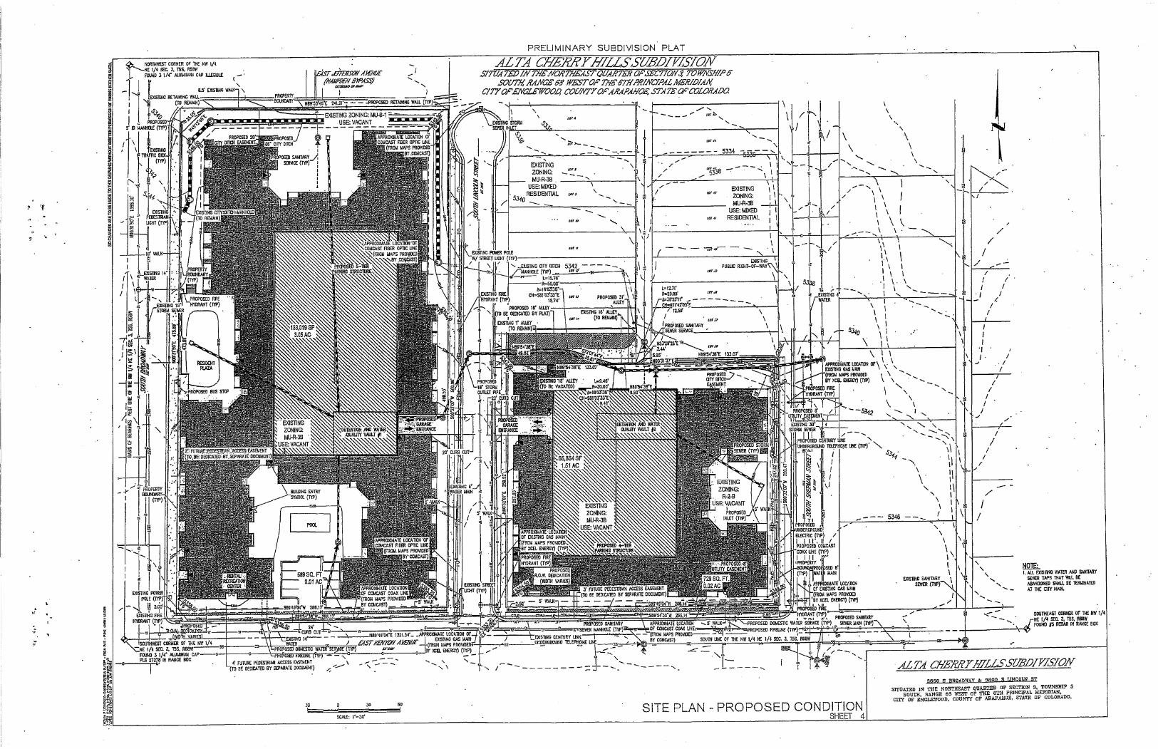
. ,,
'f
.•
JO
SCALE: 1"=30'
..... )
............. '\
60
PRELIMINARY SUBDIVISION PLAT
ALTA
' EXISTING ZONING: MU-R-38 . ---..:..-------11
USE: MIXED S RESIDENTIAL
J4Q ----
., I ...... ______ ""
,- .... IDI~· .... ....
-- .... "' UNE(nP)" "
SITE PLAN -PROPOSED CONDITION
I \
\ .,
S.J'/1-.
\
\ \ \ \
- '"'· \ \"
5346 -- I
\
I
I 1
/ /
--/
I
\
' .... .... .... _
--
\
~ I. All ElCISllNG WATER AND SANITARY
SEYlER TAPS lHAT Ym.L BE ABI\NDOHED Sli/II.L BE 'IERMINATED AT lHE CITY MAIN •
AlTA CHE.RI?Y .HI.l.lS S[JJJ.D/V/S/OH !!650 S BROADWAY & 3600 S LINCOLN ST
SITUATED IN THE NORTHEAST QUARTER OF SECTION 3, TOWNSHIP 5 SOUTH RANGE 68 WEST OF THE BTH PRINCIPAL MEI!lDlAN,
CITY OF .ENGLEITOOD. COUNTY OF ARAPAHOE, STATE OF COLORADO.

T
i.!. (!'"'
•f ••
~-_.:.··.t (1
·- .. ~ ~~ H H ~=
.BAS/SOF .Bfi'A/?/.HCS · BEARINGS ARE BASED ON lHE WEST LINE OF 'IHE
NORlHWEST QUARTER Of THE NORTHEAST QUARTER .OF SECllON 3, TOWNSHIP 5 SOUTH, RANGE 68 WEST Of' lHE 61H PRINCIPAL MERIDIAN, ASSUMED TO BEAR NORtH 00"31'50"' EAST.. '
n.oo.o C£'/tT/HCA T/OJV I HEREBY CERllFY lHAT lHE PROPERTY DESCRIBED HEREON IS..lllli lDCATED IN A 100 YEAR FLOOD PLAIN, ACCORDING TO lHE MOST CURRENT INSURANCE RATE: MAP (FIRM), PRODUCED BY 1li£ FEDERAL EMERGENCY
• "!ANAGEMEN!. A~ENCY (FEM.O,). . · . MAPS ARE DATED QEcnceni 17 ;om COMMUNITY NO. DlWIZt PANEL NO. ~
LEGEND .
---- JtfOICATES S\JB.IECT PROPERlY UN£ AS SHOWtl.
---- IHOICATES RIGHT OF Wlo.Y UMITS.
- - - - - IHOJCA1tS LOT UHE BOUNDARY,
---- IHDICAlES Of'FS£1" LINt /IS STAlED,
--··--· INDICA1£S CENTERUHE OF R.O,yt. IS SHOl'lN.
--··-- ltmiCA'I!S A UNO UN£ ,\S STo\lm f.IE'I\Ec;~
---------- lHDIC'Al£5 tASB.IENT UH£.
-·---- ltmiCAn:s BOUNDARY OF' /l.H EXCEPlED PDRlTOH.
~ FOUND CONC. HAIL WITH SRI\SS TAG PLS 25958 IN OUSB.ED Ci!DSS
A fOUND CONCREtE: Holdt. l'tmf BRASS iAC PLS 26!158
19 FDUHO iS REBAR \\llli R£tl PLI.STIC CAP PlS 2G958
·• SET ~24· REBAR WI'Jli BlUE PLAS11C CAP PLS 38162
MAJOR SUBDIVISION PLAT
ALTA CH£1?./?Y H/LLS SUB.lJ/V/S/OJV S/Tf/A T.E'.IJ 1/VTH.£ IVO.!?TH.£ASTQOA.!?T.£.!? OF S.£C7'/0JV ._f TOW.NSH/P 5
S0//7'/-i; ./UIVO.£ 6'8 .WeST OF TH.£ OTH P/?/JVC/PA.l.M.£.1?/.IJ/AH, CITY OF £'JVO.l.£1f/OO.IJ, COO./'ITY OF A.IUPAHO£; STAT.£ OF CO.lOIU.IJO.
.·:
DEDICATION KNOWN ALL MEN BY lHESE PRESENTS: tHAT lHE UNDERSIGNED WARRANTS lHAT IT IS lHE OWNER OF ·A PARCEL OF LAND LOCATED IN THE OF SECTION J, TOWNSHIP 5 SOUtH, RANGE 68 WEST OF lHE 6TH P.M., ALSO BEING PART OF CITY OF ENGLEWOOD, COUNTY OF ARAPAHOE, STATE OF COLORADO, MORE PARTICULARLY DESCRIBED AS FOLLOWS: LOTS 13 THROUGH 19, INCLUSIVE AND 26 THROUGH 38, INCLUSIVE, BLOCK 1, HIGG1NS BROADWAY ADDITION, COUNTY OF ARAPAHOE, STATE OF COLORADO: AND LOTS 20 THROUGH 25, BLOCK 1, HIGGINS BROADWAY AD01710N, COUNTY OF ARAPAHOE, STATE OF COLDRAOD: AND LOTS 10,11 AND 12, BLOCK 1, HIGGINS BROADWAY ADDITION, COUNTY OF ARAPAHOE, STATE OF COLORADO: AND • LOTS 6 THROUGH 9, INCLUSIVE AND 39 THROUGH 50, INCLUSIVE, BLOCK 1, HIGGINS BROADWAY AD01710N, COUNTY. OF ARAPAHO[, STATE OF COLORADO,
EXCEPT THAT POR'IION CONVEYED TO THE CITY OF ENGLEWOOD IN DEED RECORDED JANUARY 24, 1958 IN BOOK 952 AT PAGE 79 AND THAT POR'IION CONVEYED TO THE STAlE DEPARTMENT HIGHWAYS, Ol'llSION OF HIGHWAYS, STATE Or COLORADO IN DEED RECORDOl JULY 21,1970 II~ BOOK 1875 AT PAGE 110.
TOGETHER \\ITH
LOT 30 AND THE SOUtH ONE HALF OF LOT 31, BLOCK 2, ~IGGINS BROADWAY ADDITION, COUNTY or ARAPAHOE, STATE OF COLORADO: AND LOTS 17 AND 1B, BLOCK 2, HIGGINS BROADWAY ADDITION,
... ····-............ --------..:..---------------------+.---~---.,.-----------------------------------f~W';.,'lfijA,'i;fm~~SJ~rH~cg~o[ltf~o_'~PoCK' 2, HIGGINS BROADWAY ADDITION,
US28S
MILLER ·_fiELD
W.fdANSFIEL"nAVE · ..
STAJV.OAJll) JVOT.ES 1. 0A1E OF FIEI.O WORK: JUNE 28, 2011
2. tHIS PLAT REPRESENTS A BOUNDARY SuRVEY OF lHE PARCEL SHOWN. IT IS PART OF A SUBOI'IlSION PLAT OF "HIGGINS BROADWAY ADOI'IION" FILED llllH lHE CLERK AND RECORDER OF ARAPAHOE COUNTY ON lHE ~RD OAY OF' APRIL, 1917 A.D. RECORDED IN PLAT 'BOOK 3, PAGE 23, RECEPTION NO. 4~923.
3. ACCORDING TO COLDRADO LAW YOU MUST COMMENCE LEGAL ACl!ON BfoSEO UPON ANY DEFECT IN THIS SURVEY \\ITHIN THREE YEARS AFTER'YOU'FIRST DISCOVER SUCH DEFECT. IN NO EVENT, MAY ANY ACTION BASED UPON ANY DEFECT IN THIS'SURVEY BE ' COMMENCED .MORE THAN TEH YEARS FROM THE DATE OF lHE CERTIFICAl!ON SHOWN HEREON, · •
1. COLORADO STAlE LAW CRS 9-1.5-101 STATES tHAT ANYONE PLANNING TO DIG IN OR NEAR A PUBUC ROAD, STREET. ALLEY, RIGHT-OF-WAY, OR UTILITY EASEMENT IS TO
~~~~~~A~U~~~11&~ c~AW' a~r g~~~~~3~~6~~'/,RI~N~~TMJ;.r:DmVER AREA TO LOCATE BURIED U~ES. ' ••
S. 1li£ UNEAR UNITS FOR THIS PLAT ARE U.S, SURVEY FEET.
6 •• THIS SURVEY DOES NOT CONS'IITUTE A TITLE SEARCH BY HARRIS KOCHER SMITH TO • DETERMINE OWNERSHIP OR EASEMENTS OF RECORD. FOR ALL INFORMATION REGARDING
EASEMENTS. RICHTS•OF-IVAY AND TITLE OF RECORD, HARRIS KOCHER SMI1H REUEO UPON COMMITMENT FOR TITLE INSURANCE, COMMITMENT NO. NCS-5<29B9-HOU1 ISSUED BY FIRST AMERICAN l!TLE INSURANCE COMPANY AND HA'IlNG AN EFFECTIVE DAlE OF ~y 1, 2012 AT S:OO P.M.
7. MINIMUM EIGHT-FOOT (B') \\IDE DRY Ul!UTY EASEMENTS 'ARE HEREBY OEDICA1ED foS SHOWN HEREON. THESE EASEMENTS ARE DEDICATED TO THE CITY OF ENGLEWOOD FOR THE BENEFIT OF TH£ APPUCASLE UllLITY PROVIDERS FOR THE INSTALLATION, MAINTENANC[, AND REPLACEMENT OF ELECTRIC, GAS, Ti:LEVISION, CABLE, AND TELECOMMUNICATIONS FACILITIES (DRY UTIUTIES). UTIUTY EASEMENTS SHALL ALSO BE GRAN1ED WllHIN ANY ACCESS EASEMENTS AND PRIVATi: STREETS IN lHE SUBDIVISION. PERMANENT STRUCTURES, IMPROVEMENTS, OBJECTS. BUILDINGS, V£LLS, WAI<R METERS AND OntER D~JECTS THAT MAY INTERFERE WllH THE UTlUTY FACIUllES OR USE 'lliEROF (INlERFERING OBJECTS) SHALL NOT BE PERI.IIT1EO WITHIN SAID UTILITY EASEMENTS AND THE UllUlY PROVIDERS, AS GRANTEES, MAY REMOVE AN'( INTERFERING OBJECTS AT NO COST TO SUCH GRANTEES, INCLUDING VdTHOUT LIMITA.110N, VEGETATION. PUBLIC SERVICE COMPANY OF COLORADO AND ITS SUCCESSORS {PSCo) RESERVE THE RIGHT TO REQUIRE
~· " ·:.
li;
I iJ ..;
-~ . 8 .. ..
• W.L!HioHAVE .'
t; .g :i .,;
.W.NASsAU AVE
.:
.. 1 :;·;·.·
:
\~ .·
. ... t; 't;
t; 5 ~ ~ c !!1 .!' ::1 " ..; ..; . .,;
VICINITY MAP SCALE: 1" = 500'
Sheet Index 1 COYERS~EI!T
2 Sll!l
SWEDISH MEDICN.C~
rj.l -
1-
-.........
il' ·. h
-
·r-:-: W. MANSFIElD AVE
SURVEYORSCERTIF!CA TION I, AARON MURPHY,A REGISTERED LAND SURVEYOR IN THE STAlE 01' COLORADO DO HEREBY CERllFY 1HAT lli[ SURVEY OF' lHE At IA CHERRY Hills S!!BQIV!SION WAS MADE BY ME OR DIRECTLY UNDER MY SUPER'IlSION AND THAT THE ACCOMPAN\1NG MAP ACCURATELY AND PROPERLY SHOWS THE SURVEY THEREOF.
AARON MURPHY UCENSE NUMBER 38162 FOR AND ON BEHALF OF HARRIS KOCHER S!.IITH 1391 SPEER BLVD, SUITE: 390 DE!jVER, CO B020< •
DATE SIGNED
COUNTY OF ARAPAHOE, STATE OF COLORADO: AND THE NORtH ONE HALF OF LOT 31 AND ALL OF LOT 32, BLOCK 2, HIGGINS BROADWAY ADDITION, COUNTY OF ARAPAHOE, STAlE OF COLORADO: AND
~g~# o'f~R~.M~~~sfJ.:IG~N&,~~~~g~,'~:OrnoN, THE SOU1H ONE HALF OF LOT 20 'AND All OF LOT 21, BLOCK 2. HIGGINS BROADWAY ADDITION, COUNTY OF' ARAPAHOE', STAlE OF' COLORADO: AND LOTS 2B AND 29, 13LOcK 2, HIGGINS BROADWAY AODI1'lON, COUNTY OF ARAPAHOE, STATE OF COLORADO: AND LOTS 33, 34 AND 35, BlDCK -2. HIGGINS BROADWAY ADDITION. COUNTY OF ARAPAHOE, STAlE OF COLORADO; AND · · LDTS 26 AND 27, BLOCK 2, H!GGJNS'BROADWAY ADDITION, COUNTY OF ARAPAHOE, STATE OF COLORADO: AND LOTS 22 AND 23, BLOCK 2, HIGGINS BROADWAY ADDITION, COUNTY OF ARAPAHOE, STATE OF COLORADO: AND LOTS 15 AND 16, BLOCK 2, HIGGINS BROADWAY ADDITION, COUNTY OF ARAPAHOE, STAlE OF COLORADO,
EXCEPT THAT POR'IION CONVEYED 70 .lHE CITY. OF ENGLEWOOD BY DEED RECORDED OCTOBER 21, l964 IN BOOK 1554 AT PAGE 390. • ' " • . .
CONTAitJING A TOTAL AREA oF 19B,SD4 SQUARE F'"al' OR 4'.56 AcfiES.
THE UNDERSIGNED OWNER HAS 'BY THEsE PRESENTS LAID OUT, l'LA71EO AND SUBDI'<IDED lHE SAME INTO LOTS AS SHOWN ON THIS PLAT UNDER THE • NAME AND STYLE OF' :'AIJA cHERRY HillS SUBQMS!ON"• AND DOES HEREBY DEDICATE TO THE PUBUC ALL RIGHT-OF~WAYS AND EASEMENTS FOR lHE PURPOSES SHOWN .HEREON. • • • • . • •
• MCU1EO THISt.__.......: __ OAY OF ----.,.-,--• A.D: 20_ •
STATE OF COLORADO
COUNTY OF ARAPAHOE jss
lHE FOREGOING INSTRUMENT WAS ACKNOWLEDGED BEFORE ME THIS' DAY OF • · io ~~· . . . ·.. . 'foS ---,------,~-FOR SCHOOL DISTR!i:i NO, '1. A OU~SI•MUNI~J~A~. C~RPORATION. lllnN~ M'l' HAND AND SEAL
MY COMMisSION. EXPI~ES: ·----.NOTARY PUSUC
"--'....,--.,.-----
ADDRESS APPROVALS
·-· .. · . ·CHAIRPERSON OF THE PLANNING AND ZONING COMMISSION , DA'l£. ~
A nEST:
.RECORDING SECRETARY OF THE PLANNfflG AND ZONfNG COMMISSION
D~TE
APPROVED BY THE CITY COUNCIL BY ORDINANCE NO •• ___ _;_, SERIES OF 20_,
MAYOR OF THE {:ITY OF SNGLE!If'OOD DAlE
ATTES7:
.CITY CIERK OA~
CLERK AND RECORDS CERTIFICATION ACCEPTED FOR FILING IN THE OFFICE OF THE CLERK AND RECORDER OF ARAPAHOE
COUNTY, STAlE OF COLORADO, AT __ O'CLOCK _.M., ON lHIS ___ OAY OF
-----·,A.D., 20_, RECEPTION No:,_ ____ • BOOK NO. ___ _
PAGE NO(S) •. ____ _
B'l BY: CLERK AND RECORDER DEPUTY
ALTA CHERRY H/LJS SuB.D/VIS/OlV 3650 S BROAPWAY & 3600 S LINCOLN ST
!~ AOOITIONAL EASEMENTS AND TO REQUIRE 1HE PROPERTY OWNER TO GRANT PSCo AN ;ASEMENT ON llS STANDARD FORM.
SITUATED IN THE NORTHEAST QUARTER OF SECTION 3, T011'NSHIP 5 SOUTH, RANGE 68 WEST OF THE 6TH PRINCIPAL MERIDIAN,
C!TY OF ENGLEWOOD, COUNTY OF ARAPAHOE, STATE OF COLORADO.
~ COVER SHEET ~·~--~--------------------------------------~--------------------------------------------------------------~S~H~E~R~1u_ __ ~------~--------------------~
c
1!.,· "7:;:0 •\
"
~·
~.'
i ~ i s e =~ ~ ~ ;s
10
j T
1,0 80
SCAt£: 1"=40'
NORTHI\£ST CORNER OF THE NW 1/4 NE 1/4 SEC. 3, 155, RBBW FOUND 3 1/4" Al.lJYINIJI! CAP IlLEGIBlE
r-..,.--LOl I
L LOT~
r,.-..--·--·-·---·--·, L l.OTSO I
__ .JlOOKJSL _j
1 r ---~·-~. LOT 19 I II r-1
.j_ PAGE 79 j - _j I L - ..:.--::::.--._~ -
_ ~0~ ___ -J I ~ _ ~0~ _ -~-~ U.S. HIGHWAY 285 LOl ~7 aP~GEK
11a1gs 1
ON-RAMP n . • -,,,-- -r ,1, LOT~G
LCIT ~
LOT 5 N89"53'46"E 241.21'
I I ;.,<>'?t~:-~~:___ ----------L.-!!!':!2~--------~~~~-----'---•~ -n",~-.~-- ---:-NB!!'S3~~r- ---:----:-
.;? (\~1\~~ I I ' j f>~'(l. LQT 7 ~Rf1i~BE DEDICATED LQT
44 ! - I - - -'- -ey SEPARAlE oocuMENT - - - - - T -t ~~i LOT 8 I I l9T 43 I ~ ~·i:;: ____) l-- 1-- "l,a------ .. I I -.---- "- --:-
~ ~~1a ~ i LOT g . I I LOT 42 !'!!!'! l!1 m/11),-~- - - - - - I I - !!:-~. fi92irfo"l' LOT tO ~01 41 ! - ~ - - ~ -i t- - - - - .,,~- ·.:.....
LOT II LOT ~0
_l L 4-
LOT 12
LOT IJ
LOT 1<
~ LOT IS "' . !;r'Cn -----
~ i:i LOT IG ...,t;: ;:;-.- -----~ lot 11
LOT 18
LOT 19
LL,6' Al.tEY L~!!! VACATED BY LOT 39 SH:2TP,Z
7"--l I
--j
j....!!liS_!LA!_ ____ .....,.
I r-
I ' I,.OT 1, BLOCK 1
' 132,430 so. FT. OR 3.0+ ACRES :1:
I I . - --1 I
I
LOT ~S
LOT J7
LOT 36.
• LOT 35
LOT 34
LOT 33 ~
---j
I I
r-·------1
lOT J2 ,------LOT 20 LOT UNE VACATED 1 _ ..../~ llji!P~ (TTPS L
I L I I-
LOT 31
LOT 21 I _____ _j
LOT 22
LOT 2J
I --l
I ...., I
I
lOT JO
LOT 29
I LOT 28
r--------1 I
Lor 21
SB9'49'P4'WI 265.17' LOT 26 2.43'
. MAJOR SUBDIVISION PLAT
ALTA CH£.1?/?YH/LLSSO.B.D/V!S/OJV S/7'{1A7'£fJ 1/VTH£ HO/l7'H£'ASTQC/A/l7'£'.1? OF .5EC770H 4' TOWJlSHIP5
SO{IT.f( JUNO£ 6'8 Tf!EST OF TH£' 6'77/ P.I?/IVCI.f'A£.M.£J?I.fJIAN CITY OF£fi!Cl.l£W00£1 CVf/JVTY OF AJUPAHO£; SJ'A T£' OFCV£0./?A.fJO.
60'
~~-
~~ n---g :z:
EAST KENYON AVENUE S89"54'3B"W 266.14' RIGHT OF WAY SB9'54'3B'W 266.17' DEDICATED PER
THIS PLAT NB9'49'0+"E 1321.34' (55' R.O.W,) S1JII_!!{ LIH£0F lH£ NIP 1/.f N£ t,/£_S~ 4 T5S. H6811'
ALLEY DEDICATED BY lHIS PLAT
3 0
~ SOUTHEAST CORNER OF THE NW 1/~ • \__NE 1/4 SEC. J, T5S, R6BW
FOUND §5 REBAR IN RANGE BOX
~ SITE
PORnONOF .iili;YOEOICA7ED BY BOOK 1554 PAGE 390 VACAIDl BY THIS PLAT
ALLEY DETAIL
I.EGOO . FOUND CONCRETE NAIL \'liTH
<1> BRASS TAG PLS 26958 IN CHISELED CROSS •
"" ~:~ i:c~2r:e \'liTH
e ~~~tJ.E~~ raWsF e ~~J,~2~R~RJI~ BLUE
I --, --' I
AlTA CH£.1?.1? Y JffL.lS S{l.B.D.!Y/S.!O.N 3650 S BROADWAY & :3800 S LINCOLN ST
SITUATED IN THE NORTHEAST QUARTER OF SECTION 3, TOWNSHIP 5 SOUTH, RANGE 58 WEST OF THE 6TH PR!NCIPAL MER!DIAN,
CITY OF ENGLEWOOD, COUNTY OF ARAPAHOE, STATE OF COLORADO.
~~ SHEET 2 L-----------------------~------------------------------------------------------------------------~~~--~--------------------------~

Flood Middle School PUD Neighborhood Meeting Unite Methodist Church - 3885 South Broadway May 16, 2012
Attendees: Approximately 42 (see attached sign-in sheets)
Applicant Presentation
EXHIBIT D
1. Edward Barsocchi of Barbury Holdings, LLC, stated that his company is under contract with the Englewood School District and is set to close on the property in the first quarter of 2013. He then provided information on the proposed developer, Wood Partners, which included the following: • Wood Partners is ranked as one of the top apartment builders in the country and
has developed over 15,000 units. • Some recent projects in the metro area include the Alta project behind the Aspen
Grove shopping center an<] a project at Alameda and Cherokee. • \!Vood Partners recently completed a Leed Certified building.
2. Wendi Birchler of Norris Design thanked everyone for coming and described the current zoning for the Flood Middle School property which includes R-2-B, MU-R-3-B, and MU-B-1. She describe the development as being a 300-350 unit apartment building in two buildings, with a maximum height of approximately 65 feet.
3. Robert Miller of PBA Architects presented his firm's existence since 1967 and his ~wn tenure with the company over the last 15 years. He also Went over the conceptual plan for the development which included:
1
• The project will include an active corner on South Broadway and Kenyon. The grade steps down significantly at the northern portion of the site. There will be a buffer between the northern portion of the building and Highway 285.
• At the southern portion of the larger parcel, there will be a small amount of off-street parking for prospective tenants to visit the leasing office.
• On all the streets except Broadway, there will be a detached walk with a tree lawn. • The building will be 4 to 5 stories tall with an average height of 55 to 65 feet.
4. Public Comment The public as~ed questions and provided comments that ar~ grouped in these notes by topic .. The applicant responded to some of the questions and comments (in italics). Key issues were:
.General: Will there be 350 units total, or per building? That would be the maximum total number of units. What would the current MU-R-3-B zone district allow in terms of density? That has not been calculated, but we will have that as the process moves forward. What is the proposed landscape on Kenyon? !twill be a detached minimum 5 foot wide sidewalk with a tree lawn.

What is interactive along Broadway, there is no place for kids to play. • Is there any retail proposed? No, a recent retail study showed that additional
residential was necessary to support existing retail and any new retail development. The best way to increase existing retail performance is to increase rooftops. We don't want to increase retail vacancy rates. What is the red area in the concept plan? It is the leasing area and the community center for the apartments. In terms of infrastructure, who will pay for it? Are you asking the City for assistance? Only for assistance in relocating the City Ditch that runs through the property. What kind of demographics are you looking at? Rents will be market rate and will range from $7,000 a month for a one bedroom to $2,200-$2,500 for a three bedroom. Will crime increase? We do not have any supporting data on that.
• What cost impact is there on the City in terms of needing a new middle school?
2
Flood Middle School was closed in 2006 because of declining enrollment, so there is not a need for another middle school. The City is a different entity than the Englewood School District. ·
• Can you keep the green space east of Lincoln? No, it is not economically feasible .or the highest and best use of the land.
• Was the retail study you refer to specific to Englewood? Yes. • Is there any concept yet for the building, It should be unique to Englewood since it's
a gateway location? There is not a concept yet, but we will be working on that. • Would the developer consider a project that conformed to the current zoning
density? It's probably not economically feasible, if the project too sman then it's very difficult to find a developer. The school closed in 2007.
• Whether or not us citizens like the specific project, its progress and I'm glad it's happening.
Traffic: • There is a ten unit building on the southeast corner of Lincoln and Kenyon. There is
a concern for traffic and kids playing. • Will the signal timing be lengthened at Kenyon and Broadway? We are doing a traffic
study right now and that will be looked at. • Could all the traffic come into the project from Broadway? It is unlikely, an entrance
would likely be too close to the on-ramp to US 285 (Hampden). • Perhaps you could add an acceljdecellane and widen Broadway.
Parking: If the resident of the apartment buildings have visitors, where do they park? The parking garage will be sized to accommodate visitor spaces.
• Will the building wrap around the parking structure and how many spaces will there be? Yes, the building will wrap around the parking structure. Right now we are looking at a parking ratio of approximately 7. 7 spaces per unit. 1.7 spaces per unit seems a little low.

Construction: • How long would construction take? It would take about 90 days to complete the
demolition and environmental remediation for the school, then construction would take about 7 8 months.
• How will construction hours and traffic restrictions be determined? That has not been determined yet.
• Will fences during construction impact the RTD bus stop on Broadway, there is a resident here who is blind? We will have work with RTD to make sure that service is maintained.
Process:
3
• This concept site plan does not articulate exactly what you are proposing in terms of density, setbacks, parking, and height. We are asking for neighborhood input first, all those things will be articulated when we formally apply for the PUD.
• How residents be notified of the Planning and Zoning Commission public hearing? There will be a notice in the Englewood Hera/~ a notice on the City's website, a direct mailing to property owners and tenants within a 1,000 foot radius of the site, and the site will be posted. All of these notices will be a minimum of 10 days prior to the hearing.
• Mayor Pro Tern Jim Woodward indicated that residents can also sign up forenotifier on the City's website.
• Council Member Linda Olson, who represents the area, encouraged residents to compile emails to communicate with one another about the proposed Flood Middle School PUD. Council Member Jill Wilson indicated that she would leave some cards on the table if anyone wanted to contact her.
5. City staff outlined the PUD process and next steps. PUD frequently asked questions was provided.
6. Edward Barsocchi of Barbury Holdings made some closing remarks and the meeting was adjourned.

June 28,.2012
Brook Bell City of Englewood Community Development Department 1 000 Englewood Parkway Englewood, Colorado 80110
RE: Flood Middle School PUD, ZON2012-003 TCHD Case No. 2732
Dear Mr. Bell:
EXHIBIT E
Thank you for the opportunity to review and comment on the proposed Planned Unit Development (PUD) application for the Flood Middle School site for the development of 350 units of multifamily housing at 3695 South Lincoln Street. Tri-County Health Department (TCHD) staff has reviewed the application for compliance with applicable environmental health regulations and potential recommendations for site improvements to encourage opportunities for healthy community design.
Healthy Community Design and Connectivity Because chronic diseases related to physical inactivity and obesity now rank among the country's greatest public health risks, TCHD encourages community designs that make it easy for people to include regular physical activity, such as walking and bicycling, in the.ir daily routines. At the project site level, TCHD encourages applicants to incorporate a well-connected system of pathways for pedestrians and bicyclists that support the use of a broader pedestrian and bicycle network off of the site.
The applicant's proposed minimum sidewalk width requirement of five feet found under PUD District Plan Development Standards is a great start to provide adequate space for more than one person to pass at one time. TCHD encourages the applicant to include more requirements to ensure an on-site system of good connectivity. While TCHD recognizes that the actual site design will be evaluated with a later land development application for the site plan review, it is essential to consider PUD requirements that foster a walkable design that incorporates direct connections to the broader circulation network. You may want to consider requirements for internal circulation that maximize direct pedestrian and bicycle connections from residential buildings to adjacent public streets, nearby parks and trail system and transit stops.
The design and orientation of buildings can encourage residents' use of sidewalks along streets improving the safety on the street by bringing more people to observe activities. The bulk standards listed under PUD District Plan Development Standards begin to articulate the building presence along the street. You may want to consider adding development standards that articulate the preferred location for entrances oriented toward the streets.
Serving Adams, Arapahoe and Douglas Counties T Richard L. Vogt, MD, Executive Director Y www.tchd.org 6162 S. Willow Dr., Suite 100 Y Greenwood Village, CO 80111 .,. 303-220-9200

Flood Middle School PUD, Case No. ZON 2012-003 June 28, 2012 Page 2 of 2
A common barrier to good circulation is the overuse of fences on multifamily developments. TCHD recommends that you add standards to the PUD to clarify the intent for the use of fencing on the property. It might be helpful to limit the use of fences along the street and along internal pedestrian sidewalks. .
The Conceptual Landscape Plan includes street sections. However, there are not standards in the PUD standards. It is unclear if the streetscape standards are governed by the PUD standards or if they are determined by another regulatory document. TCHD supports the detached sidewalk design show on the conceptual plan with a minimum of five-foot wide sidewalks.
Lastly, the setback standards included under PUD District Plan Development Standards are not clear as to whether the setbacks are intended as minimum setback or maximum setback standards.
Healthy Community Design and Bicycle Amenities As mentioned earlier in this letter, TCHD supports community design that makes it easy for residents to walk or use their bicycles. TCHD encourages you to add PUD Development Standards for bicycle facilities including bike parking for visitors and residents. While bicycle storage for residents could be accommodated internal to the building, it is· important to include bicycle parking facilities that are easily accessible to visitors.
Sun Safety for Outdoor Common and Gathering Areas Skin cancer is the most common cancer in the United States. Colorado has the 51
h
highest death rate from melanoma, the most deadly form of skin cancer. A leading risk factor for skin cancer is exposure to ultraviolet rays (UV) from the sun. Seeking shade when outside is one of the best ways to prevent overexposure to UV rays. TCHD recommends the use of shade in common areas like courtyards, patios and play areas through the planting of trees or physical shade structures. It is important that shade structures or appropriate landscaping_ is considered early in the design process so that it is incorporated well into the overall site plan and optimizes the opportunity for residents and visitors to shield themselves from the sun and reduce their risk of skin cancer.
Please feel free to contact me at (720) 200-1571 or questions on TCHD's comments.
Sincerely,
I
Sheila Lynch Land Use Program Coordinator Tri-County Health Department
if you have any
CC: Warren Brown, Hope Dalton, Vanessa Richardson, Laura DeGolier, TCHD

. DEPARTMENT OF TRANSPORTATION
Region 6 Traffic Access/Utilities Permits Roadside Advertising 2000 South Holly Street Denver, Colorado 80222 303-512-4272 FAX 303-757-9886
August 31,2012
City of Englewood Attn: Brook Bell Community development department 1000 Englewood Parkway Englewood, Colorado 80110
Dear Brook:
EXHIBIT F
RE: ZON2012 .. 003 3695 SO. LINCOLN STREET SE QUADRANT OF BROADWAY BOULEVARD AND SH 285
Thank you for referring the proposal for our review. We have reviewed the site traffic study am.l we have no further comment on the site development proposal. Please note that to obtain permission to construct utilities within state highway right-of-way, a Utility/Special Use Permit is required. Please visit our website at http://www.dot.state.co.us/UtilitvProgram/Process.c:fi:n, or obtain the application through this office.
If you have any questions, please contact me at 303-512-4271.
Sincerely, Bradley T. Sheehan, P.E. Access Engineer
CCR6: Ref: 067912.docx File (SH44)
Page 1 ofl

""'e· .. t····· ··l!::n·:.· .o.rn. ·y·.· .. · ,$M Au .; . C:::l v'· , .· .. ' ..
AUQY~t ~~. 4012
Brpqk Bell .~g~0o~~;~!.~~:·~:.%~~ylhity· bev~'!qpment g·t1gl$WP~ti!; P9t()racfo· .S:Qt10
EXHIBIT G
~lght-.Of~Way.& J>erinit~ 1 dci()fWHa\hpd¢n.Ave Lakeviciqtl; c6Ioiacfo .i;lo227 telephone: i3Qi3.716,~0~3 F~~imil~:·· ~os:?1e:~p4~
R.e: E·asemenf\tacatibn ·$:3,... t5's-- R$:~3\f\r· Floqd·MiddJe· $ch<J4l :R(;):cl~.~e'l6pm·ent {AHa. Pbert;Y+lliJ~)
Pe?rMr: ;sen,
~~ii~~§~~~\;~~ili~lii~i~~i~;ti~~] Ii;il~g~a!i~i~l~j~!~i~~~f~{f,~~~:tii~~;if)[~ ~~f:nt/:·u~C%~v;;t~~;· .. ~B-C: 1i~~,·~·$~~~·~:~~er~:~:.t.i~)~~~·p.R~ntJ.j~~ti~bvw·~~=:~ app:roval by the Ctty.of ltn£fleWoocL ·
.$houfct }'ou h~V~ any que$flons or need agdifio.nal ihfQrroatkfii dq· not he$'itate lC> Gont~Qt rrte.
i~P PY J'!;~ijnn contfC1,ctr~ight.·01:.;wft'y Agerit 363/7:16.2043 .

July 23, 2012
City of Englewood Community Development Department Mr. Brook Bell 1000 Englewood Parkway Englewood, CO 80110
RE: Case No.: ZON2012-003 Subdivision Referral Alta Cherry Hills Subdivision 3695 South Lincoln Street, Englewood, CO 80113
Dear Mr. Bell,
EXHIBIT H
~~~ C L. k ~~~~ entury 1n ™
In a letter dated June 26, 2012, copy attached, Qwest Corporation d/b/a CenturyLink QC denied the referenced Case due to the Case's conflict with existing CenturyLink telecommunications facilities.
Since that date, we have met with representatives ofBarbury Holdings, LLC to seek remedy to known conflicts. ·
As a result of agreements arrived at during that meeting, Century Link can approve the Alta Cherry Hills Subdivision contingent on Barbury Holdings, LLC providing a utility easement for CenturyLink use, compensating CenturyLink for relocating our existing facilities into the new easement and on the preservation and maintenance of all existing rights until CenturyLink's relocation is final.
Sincerely,
Charles Place Engineer II I Right ofWay Manager Century Link 9750 E. Costilla Ave. Englewood, CO 80112
303.784.0217
June ~6, 2012
City of Englewood Community Development Department Mr. Brook Bell 1000 Englewood Parkway Englewood, CO 80110
RE: Case No.: ZON2012-003 Subdivision Referral Alta Cherry Hills Subdivision 3695 South Lincoln Street, Englewood, CO 80113
Dear Mr. Bell,·
~~~ C L. k ~4~~ entury 1n ™
Please be advised that Qwest Corporation d/b/a Century Link QC has reviewed the materials provided by this proposal.
CenturyLink was not able to agree to proposed alley and utility ~asement vacations presented by associated Cases SUB2012-003 and SUB2012-004, respectively, due to conflicts with existing CenturyLink faciliti¥s.
Those unresolved conflicts encumber the proposed Lot 1, Block 2, Alta Cherry Hi.Us Subdivision. ·
Therefore, Century Link cannot agree to the proposed platting, until such time as conflicts with our facilities· are resolved.
Bradbury Holdings, LLC should contact CenturyLink Engineer Tim Styron, 303.792.1963, to discuss removing this conflict with Bradbury's proposed Alta
\....llt:rry .OlliS ~UDOlVISIOn.
Thank you for the opportunity to review the referenced Case.
Sincerely,
Charles Place Engineer II I Right of Way Manager Century Link 9750 E. Costilla Ave. Englewood, CO 80112
303.784.0217

July 23, 2012
City of Englewood Community Development Department Mr. Brook Bell 1000 Englewood Parkway Englewood, CO 80110
RE: Case No.: SDB2012-003 Alley Vacations Block 1 & 2, Higgins Broadway Addition
Dear Mr. Bell,
~~~ C L. k ~~~ entury · 1n ™
In a letter dated June 26, 2012, copy attached, Qwest Corporation d/b/a CenturyLin.k QC denied the referenced Case due to the Case's conflict with existing CenturyLink telecommunications facilities.
Sinc.e that date, we have met with representatives of Barbury Holdings, LLC to seek remedy to known conflicts. ·
As a result of agreements arrived at during that meeting, Century Link can approve the requested alley vacations contingent on Barbury Holdings, LLC providing a replacemeut easement, compensating CenturyLink for relocating our facilities from the alley (at Block 2, Higgins Broadway Addition) into the new easement area and on the preservation and maintenance of all existing rights until Century Link's relocation is final.
Sincerely,
Charles Place Engineer II I Right of Way Manager Century Link 9750 E. Costilla Ave. Englewood, CO 80112
303.784.0217
June 26, 2012
City of Englewood Community Development Department Mr. Brook Bell 1 000 Englewood Parkway Englewood, CO 80110
RE: Case No.: SUB2012-003 Alley Vacations Blocks 1 & 2, Higgins Broadway Addition
Dear Mr. Bell,
~~~ C L. k ~4~ entury tn TM
Please be advised that Qwest Corporation d/b/a CenturyLink QC has reviewed the materials provided by this proposal.
Century~ink cannot agree to the requested easement vacation at this time. Our records indicate we own, operate and maintain buried cable in the alley at Block 2, Higgins Broadway Addition. (We do not have cable in the alley at Block 1 and .will be able to agree to that portion of the
· vacate request.)
Bradbury .Holdings, LLC should contact Century Link Engineer Tim StYron , 3 03.792.1963, j · to discuss removing this conflict with Bradbury's proposed Alta Cherry Hills Subdivision.
Thank you for the opportunity to review the referenced Case.
Sincerely,
Charles Place· · Engineer II I Right of Way Manager CenturyLink 9750 E. Costilla Ave. Englewood, CO 80112
303.784.0217

July 23,2012
City of Englewood Co:tnmunity Development Department Mr. Brook Bell 1000 Englewood Parkway Englewood, CO 80110
RE: Case No.: SUB2012-004 Utility Easement Vacation (Reception No. 1409544) Block 2, Higgins Broadway Addition
. Dear Mr. Bell,
~~rt: C L. k ~4~ entury 1n TM
In a letter dated June 26, 2012, copy attached; Qwest Corporation d/b/a CenturyLihlc QC denied the referenced Case due to ilie Case's conflict with existing CenturyLink telecommunications facilities.
Since that date, we have met with representatives of Barbury Holdings, LLC to seek remedy to known conflicts.
As a result of agreements arrived at during that meeting, Century Link can approve the requested Utility Easement Vacation (Reception No. 1409544) contingent on Barbury Holdings, LLC providing a replacement easement, compensating Century Link for relocating our facilities and on the preservation and maintenance of all existing rights until Century Link's relocation is final.
Sincerely,
Charles Place Engineer II I Right ofWay Manager Century Link 9750 E. Costilla Ave. Englewood, CO 80112
303.784.0217

June 26, 2012
City of Englewood Community Development Department Mr. Brook Bell 1000 Englewood Parkway Englewood, CO 80110
RE: Case No.: SUB2012-004 Utility Easement Vacation (Reception No. 1409544) Block 2, Higgins Broadway Addition
Dear Mr. Bell,
~~~ C L. k ~~~ entury 1n ™
Please be advised that Qwest Corporation d/b/a CenturyLink QC has reviewed the materials provided by this proposal. ·
Century Link cannot agree to the r~quested easement vacation at this time. Our records indicate we own, operate and maintain buried cable in the easement area.
BradburvHoldings, LLC should contact CenturyLinkEngmeerTim Styron, 303.792.1963, , to discuss removing this conflict with Bradbury's proposed Alta
Cherry Hills Subdivision.
Thank you for the opportunity to review the referenced Case.
Sincerely,
Charles Place Engineer II I Right of Way Manager Century Link 9750 E. Costilla Ave: Englewood, CO 80112
303.784.0217
_,,,..,. •• •• ~...,.....,...,..,,_.,.,..., __ ,.~ ·····~ r• •• •• • • .. , .. !;:, ;. • • r<• .-1
•f)
: ·~ • I ,• . !. •, :•:'. :. .•. - _ ... ·=-.:!..-..-·...:..:- •• ::. .•• _ ··-· ............ :: :=:

Brook Bell
-----~---
From: Leigh Ann Hoffhines Sent: Tuesday, August 28, 2012 8:18AM To: #City Council Cc: Alan White; Darren Hollingsworth Subject: FW: Mary L. Flood Park
EXHIBIT I
FYI- This is Mayor Penn's response to the email Council received regarding the park near Flood Middle School.
Leigh Ann
Leigh Ann Hoffhines Englewood City Manager's Office
From: Randy Perin S,ent: Tuesday, August 28, 2012 8:14AM To: Casey Hannen Cc: Leigh Ann Hoffhines Subject: RE: Mary L. Flood Park
Casey, Thank you for your letter. This project is well on it's way and this info should have been brought forward at the community meetings. At this time the project is being developed by the Bradbury group along with Wood Partners. The Flood property has never been designated at a park, but in the past was utilized by many citizens as a park. The City is always interested in maintaining their park system and at this time is not looking at the Flood properties as an addition to the system. The developers will be paying a "Park Fee" payment to the city to help continue the sustainability and upgrading of parks around the city and close to the Flood properties. The closest park setting for your area would then be Hosanna Park on Logan at the high school, two blocks from Flood. My suggestion to you is to continue with your meetings, get in touch with the Bradbury group and share your concerns, and let Englewood Public Schoois know of your concerns. I believe there will be council members at the meeting on Wednesday to listen and answer questions. Thanks, Randy Penn
From: Casey Hannen L _ _ ] Sent: Monday, August 27, 2012 10:46 PM To: Council; Randy Penn Subject: Mary L. Flood Park
Hello Englewood City Council Members and Mayor Penn,
My name is Casey Hannen and I live at the corner of Sherman and Mansfield, within walking distance of the old Mary L. Flood middle school and adjacent open space. I'm concerned about the redevelopment plans proposed by Barbury Holdings for a number of reasons - however, my biggest concern is that this community will lose an important neighborhood park and recreation area.
Useable parks and open space are important for any community, and in this case Mary L. Flood park is essentially the only park available to our neighborhood. The Hosanna Athletic Complex is in use by team sports the majority of the time, the Little Dry Creek area is narrow and sloped, and Miller Field is not suitable walking distance across Broadway. I see children playing in the park on a daily basis- if the park was to be redeveloped into apartments,
1
what other options would they have for recreation?
There are too many people in this area who enjoy Mary L. Flood park - please consider this when working with the developers on future plans for our neighborhood. I'm not opposed to redevelopment of the area, but I believe that it's primary function as a community gathering place should be kept intact.
Thanks, Casey Hannen 3894 S Sherman St 720.938.2273
!Example ]ign for Mary L. Rood Park:
2

Brook Bell
From: Leigh Ann Hoffhines On Behalf Of Council Sent: Tuesday, August 28, 2012 2:28 PM To: #City Council Subject: FW: Flood Middle School Redevelopment
FYI- this message came in via the Council email.
Leigh Ann
Leigh Ann Hoffhines Englewood City Manager's Office
From: Matt Blomstrom I Sent: Tuesday, August 28, 2012 2:19 PM To: Council Subject: Flood Middle School Redevelopment
Dear Mayor Penn and City Council Members,
EXHIBIT J
I am writing to ask you to preserve the athletic fields at the former Flood Middle School site as a future park site. There is already a shortage of parks and open space in Englewood and allowing public property to be developed as a high density residential complex will only worsen the situation.
To be clear, I support the redevelopment of the school site. I am not opposed to having a large apartment complex replace the Flood Middle School building, assuming traffic and other concerns can be dealt with. But I cannot under any circumstance support developing another large apartment complex on the only remaining open space in our neighborhood. The city has documented a need for park land in this area and if we allow this site to be developed there will not be another opportunity to address this need.
I strongly believe that preserving this space will benefit downtown Englewood far more than one more apartment building. There are many large complexes already in the area and there will undoubtedly be many more developed. Where are the children living in these complexes going to play? Where can people throw a ball around? If we want families in our neighborhoods, we need to make spaces for families to enjoy. I don't think we should all have to drive to Belleview Park or Harvard Gulch just to enjoy the outdoors. If Englewood is to become a walk-able community, we need to have things worth walking to.
I urge you to consider what kind of community we want Englewood to be like in twenty years. To keep our residential neighborhoods - both high density and single family- healthy and attractive we need open space
1

and recreational amenities. Once this open space is gone, we are not going to have an opportunity to meet these needs. Who is going to look back and think "I really wish we had built one more apartment building?" This is a . public property and it should continue to provide benefits to the public.
Thank you for your time.
Sincerely,
Matt Blomstrom
3837 S. Lincoln St.
2

Brook Bell
From: Leigh Ann Hoffhines Sent: Wednesday, August 29, 2012 2:24 PM To: #City Council Cc: Alan White Subject: FW: Flood Middle School
EXHIBIT K
FYI- here is Mayor ProTem Woodward's response to the email received earlier today regarding Flood Middle School.
Leigh Ann
Leigh Ann Hoffhines Englewood City Manager's Office
From: Jim Woodward Sent: Wednesday, August 29, 2012 1:55 PM To: Skip Anthony Cc: Leigh Ann Hoffhines Subject: FW: Flood Middle School
Thank you for your e-mail.
First, the City of Englewood does not own Flood Middle School or any of the property associated with it. It is owned by the Englewood School District, which is an entirely different governmental entity than the City of Englewood.
It is my understanding that the Flood property is currently under contract for sale to a developer looking at developing the property into an upscale apartment community as described at a neighborhood.meeting approximately one month ago. It is my belief that the proceeds from the sale will be utilized by the School District to enhance the schools within the Englewood School District to the benefit of our children. Additionally, the property would start generating tax revenue to the School District, City and County. Currently and in the past it has not generated any tax revenue.
In my opinion, the City is not in a financial position to consider purchasing the property, removing the building and constructing a park. Living in close proximity (Mansfield and Pearl) to the Flood property for the past 35 years, I believe we do have close options of open space, specifically the Little Dry Creek Greenway and trail; and Hosanna Athletic Complex. I do believe some enhancements are needed in our area of town, specifically play ground equipment for children. The City's Master Park Plan does address this need and the reorganization of the Miller Field Park on the west side of Broadway to include playground equipment. These upgrades and changes will be considered as funds are available.
Considering your suggestion from a real estate perspective of "highest and best use," removing the Flood Building and replacing it with a park would not meet the criteria for use in my opinion professional opinion. Coming from a quality of life perspective, what you suggest would be wonderful for the immediate area, however, very costly to all the taxpayers of Englewood.
Regards,
Jim Woodward, Mayor Pro Tern City ofEnglewood, CO
Sender and receiver(s) should be mindful that all rny incoming and outgoing emai!s may be subject to the Colorado Open Records Act, § 24-72-100.1, et seq.
1

From: Leigh Ann Hoffhines On Behalf Of Council Sent: Wednesday, August 29, 2012 12:37 PM To: #City Council Cc: Alan White Subject: FW: Flood Middle School
FYI-this message came in via the Council email.
Leigh Ann
Leigh Ann Hoffhines Englewood City Manager's Office
From: Skip Anthony [mailto:! Sent: Tuesday, August 28, 2012 6:38PM To: Council Subject: Flood Middle School
Dear Englewood City Council, I'm curious to know what will be done with the ageing middle school on Kenyon and Broadway. I
have heard talk of the public land being developed into apartments. Is this true? I'd hate to think the city ridding its self of open land. I myselffmd the park an enjoyable place to go. Id hate to see more concrete and walls put up.
Why don't we just tear down the un used school and make a nice park. I believe this is what every property owner and renter in the area would like. Please let me know. Thanks for your time, Skip Anthony
2

Brook Bell .
From: Leigh Ann Hoffhines On Behalf Of Council Sent: Friday, August 31, 2012 2:16PM To: #City Council Cc: Alan White Subject: FW: Mary L. Flood Park Importance: High
FYI -this message came in via the Council email.
Leigh Ann
Leigh Ann Hoffhines Englewood City Manager's Office
--·-------·---· From: [email protected] [mailto: Sent: Friday, August 31, 2012 1:41 PM To: Council Subject: Mary L. Flood Park Importance: High
City of Englewood Englewood Civic Center 1000 Englewood Parkway Englewood, CO 80110
Dear Mayor Penn and City Council Members,
EXHIBIT l
Parks and open spaces are a vital part of the community. They provide direct health, environmental, economic, and social benefits and help to strengthen our neighborhoods. Englewood has an opportunity to provide parkland to one of its least served areas, but not without action on your part. I urge you to preserve Mary L. Flood Park for future generations.
The City of Englewood has documented a shortage of park space in the neighborhoods surrounding the former Flood Middle School site and the downtown area. Furthermore, Englewood's Parks and Recreation Master Plan states th~t high density residential developments "have not been preferred by families, perhaps partly because of the lack of parks for outdoor recreation activities. If families are to be living in higher density housing, the city should seriously consider an aggressive approach to obtaining adequate parkland very near or within redevelopment projects." With the many large residential complexes in the area we cannot afford to waste the opportunity that this site provides. Mary
1

L. Flood Park can help alleviate the shortage of park space in our neighborhoods and support the city's desire to make high density living more attractive in the downtown area.
Clearly the former school building needs to be redeveloped. If the structure itself cannot be reused, then something new should be built on this prominent site. But this site is public property and any · redevelopment should take the public's best interests into consideration. Protecting the existing open space (which is about one third of the total former school site) can improve the long.,.term quality and attractiveness of the redevelopment and continue to provide benefits to the public.
Preserving Mary L. Flood Park is in the best interests of our neighborhood and downtown Englewood. Someday it can provide badly needed amenities and help support a walkable city. Our downtown businesses need a strong and healthy residential community; we need to provide the basic amenities to support these residential neighborhoods. I urge you to protect this neighborhood park. Thank you.
Sincerely,
Laurie & Bert Mears
3742 S. Sherman St.
2

Planning and Zoning Coiillnission Public Hearing, Flood Middle School PUD and Alta Cherry Hills Subdivision Case #ZON2012-003 and Case SUB2012-002 September 18, 2012 Page 1 of6
CITY OF ENGLEWOOD PLANNING AND ZONING COMMISSION REGULAR MEETING September 18, 2012
Minutes and audio are available at: http://www.englewoodgov.org/Index.aspx?page=152
I. CALL TO ORDER [~:
The regular meeting of the City Planning and Zoning Commission was called to order at 7:05 p.m. in the City Council Chambers of the Englewood Civic Center, Chair Brick presiding.
Present:
Absent:
Staff:
Bleile (entered 7:12), Roth, King, Welker, Knoth, Fish, Brick, Kinton, Townley Freemire (alternate)
None
Alan White, Community Development Director Brook Bell, Planner II Nancy Reid, Assistant City Attorney
II. APPROVAL OF MINUTES [~j September 5, 2012
Mr. Fish moved: Mr. Knoth seconded: TO APPROVE THE SEPTEMBER 5, 2012 MINUTES
Chair Brick asked if there were any modifications or corrections.
There were none.
AYES: NAYS: ABSTAIN: ABSENT:
Bleile, Roth, Knoth, Fish, King, Brick, Kinton, Townley None Welker None
Motion carried.
Chair Brick announced that CASE #USE2012-015 Extension of Temporary Recycling ---Operation at-601-West-Bates-Avenue-was withdrawn -b-Y--the applicant-and _will. not be
heard tonight or in the future.
Planning and Zoning Commission Public Hearing, Flood Middle School PUD and Alta Cherry Hills Subdivision Case #ZON2012-003 and Case SUB2012-002 September 18, 2012 Page2of6
Ill. PUBLIC HEARING r~ \~
CASE #ZON2012-003 and CASE #SUB2012-002
Chair Brick stated there are two cases to be heard tonight; they will be heard concurrently but each will require a motion and they will be voted on separately.
Mr. Roth moved: Mr. King seconded: TO OPEN CASE #ZON2012-003 and CASE #SUB2012-002
AYES: NAYS: ABSTAIN: ABSENT:
Bleile, Roth, Welker, Knoth, Fish, King, Brick, Kinton, Townley None None None
Motion carried.
;'J~~t CASE #ZON2012-003
Mr. Bell was sworn in and presented the case. He reviewed the requirements for a PUD application and stated the applicant has met all of them. He provided a history of the Flood Middle School property since 2006.
Items discussed under the PUD overview included:
>- Architectural Character >- Permitted Uses >- Dimensional Standards >- Residential Density >- Setbacks >- Building Height >- Bulk Plane >- Parking >- Traffic ~ Signage >- Landscaping >- Screening and Fencing >- Drainage >- City Ditch >- Park Dedication >- Phasing

Planning and Zoning Commission Public Hearing, Flood Middle School PUD and Alta Cherry Hills Subdivision Case #ZON2012-003 and Case SUB2012-002 September 18, 2012 Page 3 of6
Mr. Bell said the PUD documents are complete and no additional conditions of approval are recommended at this time. Therefore, the Community Development Department recommends that the Planning and Zoning Commission review the Flood Middle School PUD request and forward a favorable recommendation for approval to City Council.
CASE #SUB2012-002
Mr. Bell presented the second case. He reviewed the issues included in the Alta Cherry Hills Subdivision. He stated if the Commission requires no changes from th~ Preliminary Plat to the Final Plat, Staff recommends that the Final Plat be forwarded to Council with a recommendation for approval.
The Commission had questions regarding:
~ Adding retail to the Broadway side of the project ~ New easement dedications ~ Bulk plane on north side of parcel #2 ~ How many parking spaces and where located ~ Will street parking be allowed and sight distance requirements ~ Location of bicycle parking ~ Setbacks ~ Did Parks Department consider the land for a park ~ Transparency requirements
Applicant Testimony
Numerous members of the development team were sworn in and presented testimony. A slide show of previous projects the developer has built and the proposed project was presented. Edward Barsocchi of Barbury Holdings, LLC stated the school was shuttered in 2007 and is deteriorating. In 2011, Barbury Holdings, LLC came forward with a proposal to purchase the property and build 300 to 31 0 residential apartments on the two parcels. The project would serve as a catalyst to enhance the Broadway area. Mr. Robert Miller of PBA went over. the conceptual site plan and conceptual architectural rendering. Mr. Tim McEntee of Wood Partners discussed financing for the project. Reasoning for hot including retail in the project was discussed; it does work economically.
Other discussion points included:
~ Will a project go forward if the PUD is not approved ~ How will the parking garages be regulated ~ Landscaping ~ Outdoor living spaces/patios ~ Asbestos removal

Planning and Zoning Commission · Public Hearing, Flood Middle School PUD and Alta Cherry Hills Subdivision Case #ZON2012-003 and Case SUB2012-002 September 18, 2012 Page4 of6
);> Visual impact );> Project meets the standards the City aspires to );> Safety issues for school children who walk to school );> Is the interior street private or public );> There is significant demand in the Denver area for this type of project
Public Testimony ·Q'l !~
Testimony was heard from 15 citizens. Comments included:
);> Bulk plane along the eastern portion of the north side );> Make room for a park );> Concern regarding use of current alley );> Will redevelopment occur only on school property );> Needs to be change in the property );> Don't rezone; build according to current standards > Glare from glass fronting Broadway );> Concerns about the development not providing enough parking );> Who pays to move City ditch );> Has property been purchased by developer );> Will residents in the area need parking permits to park on their street );> Concerns about height of property );> Englewood is a middle class community; don't see high-end people moving
here );> Will have a profound impact on the neighborhood );> Traffic flow concerns );> Some residents will lose their views );> Amenities are all private; not open to the public );> Shadowing of buildings onto neighboring properties );> Snow storage and removal issues );> More opportunities for car accidents );> No benefit to neighbors );> Strain on utilities; electricity goes out a lot now );> Out of scale for the neighborhood );> Will increase crime in the neighborhood );> Project will reduce property values );> Need to decrease unit numbers and provide more entrances to project );> Find a way to ensure developer builds what he is showing in renderings
A short break was taken at 10:04. At 10:10 the meeting reconvened with all members of the Commission in attendance except for Mr. Freemire, the alternate member.

Planning and Zoning Commission Public Hearing, Flood Middle School PUD and Alta Cherry Hills Subdivision Case #ZON2012-003 and Case SUB2012-002 September 18, 2012 Page 5 of6
Mr. Welker moved: Mr. Knoth seconded: TO CLOSE CASE #ZON2012-003 and CASE #SUB2012-002
AYES: NAYS:
Bleile, Roth, Welker, Knoth, Fish, King, Brick, Kinton, Townley None
ABSTAIN: None ABSENT: None
Motion carried.
Mr. Bleile moved: Mr. Fish seconded: TO CONTINUE THE PUBLIC HEARING FOR CASE #ZON2012-003
AND CASE #SUB2012-002 TO OCTOBER 2, 2012
AYES: NAYS: ABSTAIN: ABSENT:
Bleile, Roth, Welker, Fish, Townley Knoth, Kinton, King, Brick None None
Motion carried.
:'l?J~ Ms. Reid reminded the commission that the Public Hearing is closed; the Commissioners should not be taking any more testimony nor having any discussion about this project until they are back here at the next meeting on October 2nd. She also said if one of the public calls a commission member they will not be able to discuss the issue. The testimony given tonight and the evidence that was in the Staff Report are all that the Commission will consider.
Chair Brick invited the public to attend the next meeting on October 2nd. He reminded them the Commission will not be taking any further testimony at that meeting.
IV. PUBLIC FORUM 'P-i~.
There were no public comments.
V. ATTORNEY'S CHOICE ~
Ms. Reid had nothing further to report.
Planning and Zoning Commission Public Hearing, Flood Middle School PUD and Alta Cheny Hills Subdivision Case #ZON2012-003 and Case SUB2012-002 September 18,2012 Page 6 of6
VI. STAFF'S CHOICE [~' Director White stated the next meeting will be on October 2nd; tonight's Public Hearing will continue and there will be a study session on breweries and distilleries if time allows.
VII. COMMISSIONER'S CHOICE ''i~' f~~-:
M~. Kinton stated he will not be available to attend the October 2nd meeting.
Mr. Welker said he was happy to be back after missing several meetings due to illness.
Mr. Bleile apologized for being late to the meeting.
The meeting adjourned at 1 0:45 p.m.
Barbara Krediow, Recording Secretary

Planning and Zoning Commission Public Hearing Flood Middle School PUD, Study Session Brew~ries and Distilleries Case #ZON2012-003 and Case #2012-05 · October 2, 2012 Page 1 of6
CITY OF ENGLEWOOD PLANNING AND ZONING COMMISSION REGULAR MEETING
October 2, 2012
Minutes and audio are available at: http://www .englewoodgov.org/lndex.aspx?page= 152
I. CALL TO ORDER -~
The regular meeting of the City Planning and Zoning Commission was called to order at 7:00 p.m. in the City Council Chambers of the Englewood Civic Center, Chair Brick presiding.
Present:
Absent:
Staff:
Bleile, Roth, King, Welker, Knoth, Fish, Brick, Townley Freemire (alternate)
Kinton
Alan White, Community Development Director Brook Bell, Planner II Nancy Reid, Assistant City Attorney
II. APPROVAL OF MINUTES September 18, 2012
Mr. Knoth moved: Mr. Fish seconded: TO APPROVE THE SEPTEMBER 18, 2012 MINUTES
Chair Brick asked if there were any modifications or corrections. There were none.
AYES: NAYS: ABSTAIN: ABSENT:
Bleile, Roth, Welker, Knoth, Fish, King, Brick, Townley None None Kinton
Motion carried.
Ill. CASE #ZON2012-003 - FLOOD MIDDLE SCHOOL PLANNED UNIT DEVELOPMENT AND CASE #SUB2012-002 ALTA CHERRY HILLS SUBDIVISION CONTINUED FROM SEPTEMBER 18, 2012
Planning and Zoning Commission Public Hearing Flood Middle School PUD, Study Session Breweries and Distilleries Case #ZON2012-003 and Case #2012-05 October 2, 2012 Page 2 of6
.~ l;gJ
Mr. Knoth moved: Mr. Welker seconded:
Discussion points included:
THAT CASE #ZON2012-003 TO REZONE 3695 SOUTH LINCOLN STREET AKA PIN NUMBERS 2077-03-1-08-004 AND 2077-03-1-09-006 FROM MU-R-3-B, MU-B-1 AND R-2-B ZONE DISTRICTS TO PLANNED UNIT DEVELOPMENT (PUD) BE RECOMMENDED FOR APPROVAL TO CITY COUNCIL WITH A FAVORABLE RECOMMENDATION FOR ADOPTION AS WRITTEN
~ Generally in favor of the application; appropriate use for property ~ Concerns regarding traffic ~ No problem with height or proposed character of building ~ City has no obligation or right to take land for a park unless they can pay for it. That
would destroy the viability of the whole project ~ From a Planning and Zoning standpoint the Parks and Recreation Commission
handles park planning and they have their own Master Plan. Planning and Zoning has never been involved in that process. We have no authority to become involved in it; City Council may want to become involved.
~ Can see why retail won't work at this location ~ Property is a difficult piece of property to develop ~ Number of units is too high; can't support 350 units ~ Required landscape has been reduced too much; recommend 20% ~ Need two entrances into the project ~ Will bring business to the downtown area; grocery stores will benefit ~ As a City we talk about how we want better projects and developers in this town;
we have one here. ~ There is no more greenfield space in Englewood to build out; future projects are
going to be dense projects and traffic issues will be discussed. Experts in this field have said there are no issues with this project.
~ Fee-in-lieu is too low; City Council should not have considered reducing it ~ Hold to the setbacks and to the amenity zones as presented; don't take anything
else away from the community ~ Is high density; City needs rooftops to make retail work ~ Disappointed the City of Englewood School Superintendent did not attend the
meetings ~ Disappointed business owners did not attend the meetings ~ Sensitive to cost per unit; project needs to be dense to make it work ~ Sensitive to impact on area; a retail development would be very challenging in
regards to traffic

Planning and Zoning Commission Public Hearing Flood Middle School PUD, Study Session Breweries anq Distilleries Case #ZON2012-003 and Case #2012-05 October 2, 2012 Page 3 of6
~ There are areas along Big Dry Creek and by the high school that could be upgraded with amenities that would make it more family oriented to serve this neighborhood as park space. School district could step up and help the City with this in the future.
~ Reservations regarding what has been shown and what will really get built
Mr. King moved: Mr. Welker seconded: TO AMEND THE ORIGINAL MOTION TO INCLUDE THE
MAXIMUM NUMBER OF ALLOWED UNITS SHALL BE 310
AYES: NAYS:
Roth, King, Brick, Welker, Fish, Townley Knoth, Bleile
ABSTAIN: None ABSENT: Kinton
Motion carried.
Mr. Fish moved: Mr. Brick seconded: TO AMEND THE ORIGINAL MOTION TO INCLUDE A
MINIMUM 20% OF THE PROPERTY SHALL BE LANDSCAPED
AYES: NAYS:
Brick, Welker, Fish, Townley, Bleile Knoth, Roth, King
ABSTAIN: None ABSENT: Kinton
Motion carried.
Mr. Bleile moved: Mr. King seconded: TO AMEND THE ORIGINAL MOTION TO INCLUDE
THE PARK DEDICATION FEE-IN-LIEU SHALL NOT BE REDUCED FROM THE CITY COUNCIL ADOPTED FEE OF $20,000 PER REQUIRED ACRE AS REQUIRED BY THE UNIFIED DEVELOPMENT CODE [DIRECTOR'S NOTE: THE UNIFIED DEVELOPMENT CODE ESTABLISHES THE METHOD FOR CALCULATING THE REQUIRED ACREAGE. COUNCIL ADOPTED THE $20,000 PER ACRE AS A POLICY BY RESOLUTION]
AYES: NAYS:
Roth, King, Brick, Welker, Fish, Townley, Bleile None
ABSTAIN: Knoth ABSENT: Kinton
Motion carried.
Planning and Zoning Commission Public Hearing Flood Middle School PUD, Study Session Breweries and Distilleries Case #ZON2012-003 and Case #2012-05 October 2, 2012 Page 4 of6
Mr. Knoth moved: Mr. Welker seconded: THAT CASE #ZON2012-003 TO REZONE 3695 SOUTH
LINCOLN STREET AKA PIN NUMBERS 2077-03-1-08-004 AND 2077-03-1-09-006 FROM MU-R-3-B, MU-B-1 AND R-2-B ZONE DISTRICTS TO PLANNED UNIT DEVELOPMENT (PUD) BE RECOMMENDED AS WRITTEN FOR APPROVAL TO Cf7Y COUNCIL WITH A FAVORABLE RECOMMENDATION FOR ADOPTION WITH THE FOLLOWING AMENDMENTS:
1. The maximum number of allowed units shall be 310. 2. A minimum 20% of the property shall be landscaped 3. The Park Dedication Fee-in-lieu shall not be reduced from
the City Council adopted fee of $20,000 per acre as required by the Unified Development Code [Director's Note: The Unified Development Code establishes the method for calculating the required acreage. Council adopted the $20,000 per acre as a policy by resolution.]
AYES:. NAYS:
Roth, Brick, Welker, Fish, Knoth, Townley Bleile, King
ABSTAIN: None ABSENT: Kinton
Mr. Fish finds the development as proposed with the amendments is within the nature of the Comprehensive Plan. Overall, it is an exciting project and he supports it; it is good for the City as the property is an eyesore. His objections are that it is very dense and doesn't want the character of the area destroyed.
Mr. Knoth is discouraged about adding the amendments.
Mr. Welker said in keeping with the requirements and the vision of the Comprehensive Plan this takes a step in the same direction. The density along Broadway and a major highway intersection is fine. The Amendments are an attempt to address our concerns.
Ms. Townley said the project meets the City's mixed housing goals.
Mr. Bleile said the proposal meets Roadmap Englewood for densification. Not enough shown architecturally; voting no with the citizens.
Mr. King generally likes the concept of the project, but due to public comments voting no.
Chair Brick said the project will help businesses in the City and meets the criteria for a PUD.
Motion carried.
Plruming and Zoning Commission Public Hearing Flood Middle School PUD, Study Session Breweries and Distilleries Case #ZON2012-003 and Case #2012-05 October 2, 2012 Page 5 of6
[?]j Mr. Roth moved: Mr. Welker seconded: THAT CASE #SUB2012-002 TO ALLOW A MAJOR
SUBDIVISION KNOWN AS ALTA CI-IERRY HILLS SUBDIVISION WITHIN THE FLOOD MIDDLE SCHOOL PLANNED UNIT DEVELOPMENT (PUD) BE RECOMMENDED FOR APPROVAL TO CITY COUNCIL WITH A FAVORABLE RECOMMENDATION FOR ADOPTION.
AYES: NAYS: ABSTAIN: ABSENT:
Roth, King, Brick, Welker, Fish, Knoth, Townley Bleile None Kinton
Motion carried.
Q FURTHER RECOMMENDATIONS FOR CITY COUNCIL:
1. The Park Dedication Fee-in-Lieu money collected from this project , shall be used to benefit this neighborhood in terms of open space and parks.
Mr. Bleile moved: Mr. Roth seconded: TO REQUIRE EVIDENCE AND TESTIMONY FROM THE CITY'S
TRAFFIC ENGINEER TO VET OUT AND EITHER PROVE OR CONTRADICT THE TRAFFIC STUDY DONE BY THE APPLICANT.
AYES: NAYS: ABSTAIN: ABSENT:
Roth, Brick, Welker, Townley, Bleile Fish, Knoth, King None Kinton
Motion carried.
STUDY SESSION t~ ,·.=
Director White introduced Christina Kachur, an intern in the Community Development Department, who is assisting Staff in gathering information for the Breweries and Distilleries discussion.
Case #2012-05 Breweries and Distilleries

Planning and Zoning Commission Public Hearing Flood Middle School PUD, Study Session Breweries and Distilleries Case #ZON2012-003 and Case #2012-05 October 2, 2012 Page 6 of6
Director White stated after research the State Statutes do not provide much guidance in terms of production limits for various types of manufacturers engaged in producing beer, wine and hard liquor except for brewpubs and limited wineries. What that means is any limits that the Commission wants to set are up to our discretion. He provided information on licensing of various types of establishments. There is no local control except through zoning. He referenced options that were included in the Staff Memo. He asked the Commission if they would like to include some amendments in the Unified Development Code to address these uses.
Consensus from the Commission was to move forward with the discussion in the future.
Director White said there is one other topic on Staff's list for discussion; PUDs. What is the process? Staff would like to hold a Study Session to discuss PUDs. The Commission asked the topic be placed on a future agenda.
IV. PUBliC FORUM {~
There was no public in attendance.
V. ATTORNEY'S CHOICE ~
Ms. Reid had nothing further to report.
VI. STAFF'S CHOICE
Director White stated at the October 16th study session Staff will provide a progress report on the Station Area Master Plan for the areas surrounding the Light Rail Stations.
VII. COMMISSIONER'S CHOICE ~
The Commissioners commented on tonight's discussion regarding the Flood Middle School PUD and Major Subdivision. They feel it is a good project.
Mr. Freemire noted he will not be available for the October 16th meeting.
Ms. Townley stated she will not be available for the November 6th meeting. She asked about the Oxford Station PUD. Director White updated the Commission on the project.
The meeting adjourned at 9:10 p~m.
Is/ Barbara Krecklow Barbara Krecklow, Recording Secretary

CITY OF ENGLEWOOD PLANNING AND ZONING COMMISSION
IN THE MATTER OF CASE #SUB2012-002 FINDINGS OF FACT, CONCLUSIONS AND RECOMMENDATIONS FOR A MAJOR SUBDIVISION AT 3695 SOUTH LINCOLN STREET
INITIATED BY: Barbury Holdings, LLC 4725 South Monaco Street, Suite 205 Denver, Colorado 80237
) ) ) FINDINGS OF FACT AND ) CONClUSIONS OF THE ) CITY PLANNING AND ) ZONING COMMISSION ) ) ) ) ) )
Commission Members Present: Brick, Bleile, Fish, Roth, Welker, King,. Kinton, Townley
Commission Members Absent: Kinton
This matter was heard before the City Planning and Zoning Commission on September 18 and October 2, 2012, in the City Council Chambers of the Englewood Civic Center.
Testimony was received from Staf( from the applicant and from area residents. The Commission received notice of Public Hearing, Certification of Posting, Staff Report and supplemental information from Staff, which were incorporated into and made a part of the record of the Public Hearing.
After considering statements of the witnesses, and reviewing the pertinent documents, the members of the City Planning and Zoning Commission made the following Findings and Conclusions.
FINDINGS OF FACT
1. THAT the request for a Major Subdivision was filed by Barbury Holdings, LLC on june 4, 2012.
2. THAT Public Notice of the Public Hearing was given by publication in the Englewood Herald on September 7, 2012 and was on the City's website from September 6, 2012 through October 2, 2012.
3. THAT the property was posted as required, said posting setting forth the date, time, and place of the Public Hearing.
4. THAT Planner Bell testified the request is for approval of a Major Subdivision. Mr. Bell testified to the criteria the Commission must consider when reviewing a
1
subdivision plat application. Mr. Bell further testified that Staff recommends approval of the subdivision plat application.
5. THAT in 2006, Englewood Public School District made the decision to consolidate two middle schools and close the Flood Middle School site; the school closed in 2007.
6. THAT in 2011 Barbury Holdings, LLC came forward with a proposal to purchase the property consisting of two parcels totaling 4.56 acres.
7. THAT preliminary plans of the proposed subdivision plat was referred to Tri-County Health, the Colorado Department of Transportation (COOT), RTD, Xcel Energy, Century Link, Comcast, and the City's list of trash haulers for review and comment.
8. THAT the subdivision plat was reviewed by the City's Development Review Team (DRT) on june 30th, August 1oth, and August 30th of 2012.
CONCLUSIONS
1. THAT the application was filed by Barbury Holdings, LLC seeking approval for a Major Subdivision for the property located in the Flood Middle School Planned Unit Development.
2. THAT proper notification of the date, time, and place of the Public Hearing was given by publication in the official City newspaper, and by posting of the property for the required length of time.
3. THAT all testimony received from staff members, applicant team members, and the general public has been made part of the record of the Public Hearing.
4. THAT the proposed Flood Middle School PUD use is multi-unit dwelling with a wrapped parking garage and limited surface parking; these uses are compatible with adjacent City of Englewood R-2-B, MU-R-3-B and MU-B-1 zone district uses.
5. THAT the proposed lots are compatible with dimensions established by the Flood Middle School PUD.
6. THAT public water and sewer along with electric, gas, and communication utilities are available to the subject property.
7. THAT the subject property is not located within an identified flood plain zone.
8. THAT the relocation of a portion of the public alley proposed within this subdivision provides the necessary access to the lots adjacent to the subdivision.
2

9. THAT minimum 5 foot wide sidewalks are provided.
10. THAT no bicycle facilities are required for this proposed subdivision. Sidewalks are provided.
11. THAT Council will be considering a final fee-in-lieu of land dedication amount once the PUD process is completed. The easements necessary for public uses and utilities are either dedicated on the subdivision plat or are to be dedicated by separate document.
12. THAT a drainage study has been completed as part of the proposed Planned Unit Development application. Drainage issues have been addressed and will be monitored in the development permit process.
DECISION
THEREFORE, it is the decision of the City Planning and Zoning Commission that the application filed by Barbury Holdings, LLC for a Major Subdivision known as Alta Cherry Hills Subdivision be recommended to City Council for approval.
The decision was reached upon a vote on a motion made at the meeting of the City Planning and Zoning Commission on October 2, 2012, by Mr. Roth, seconded by Mr. Welker, which motion states:
AYES: NAYS: ABSTAIN: ABSENT:
THAT CASE #SUB2072-002 FOR A MAJOR SUBDIVISION KNOWN AS ALTA CHERRY HILLS SUBDIVISION BE RECOMMENDED FOR APPROVAL TO CITY COUNCIL WITH A FAVORABLE RECOMMENDATION FOR ADOPTION.
Brick, Knoth, Fish, Roth, Welker, King, Townley Bleile None Kinton
The motion carried.
These Findings and Conclusions are effective as of the meeting on October 2, 2012.
BYORnFR ~ THI= riTY PI ANNINr. "'70NING COMMISSION
Johr{Bric~ Chair
l
3

Brook Bell
From: Sent: To: Subject:
-----Original Message----From: Frank Forney [mailto:i
Barbara Krecklow on behalf of Community Development Tuesday, September 25, 2012 7:51 AM Alan White; Brook Bell FW: Flood Middle School property
Sent: Monday, September 24, 2012 8:47PM To: Council; Community Development Cc: Randy Penn; Jim Woodward; Jill Wilson Subject: Flood Middle School property
Greetings fellow Englewood residents and City Officials!
EXHIBIT M.
Regarding the redevelopment of the Flood Middle School property, I believe that it is important that the City and all Applicants publicly acknowledge that something good for Englewood already exists on this location: an open space, a green grass playing field and a (generally defined) neighborhood park. This is a quiet oasis nestled against the busy traffic corridors of South Broadway and Hampden/285.
This currently existing public good needs to be acknowledged! Then, any proposed development need to demonstrate how it will be an improvement on the good which already exists!
Please consider the following negative factors which argue against the proposed development:
•The proposed apartment and parking structures (which build out to the very perimeter of the properties and to a height of 50 feet and more) are not in keeping with the character of the neighborhood.
•The proposed development does not add amenities to the neighborhood. On the contrary, it removes valuable open space and creates instead an insulated community within a community.
•One single vehicular access in and out of the compound, as proposed, creates a traffic bottle-neck at Kenyon and Broadway. This only multiplies the problems created by adding hundreds of new commuters to the neighborhood.
The positive factors in favor, as I heard them, are:
•All properties at the location will be settled. Troublesome maintenance problems will be resolved.
•Money will flow directly into school district coffers. New Englewood residents will shop, spend money, and pay taxes.
•The proposed development will serve as the "Gateway to South Broadway."
1

As an aside I would ask: Is Englewood a city in need of more housing in order to meet the needs of a growing population? Or is Englewood a city in heed of more population in order to raise money for the city?
At any rate, we are considering the disposition of neighborhood public property. Yes, I understand that the Planning and Zoning Commission must consider applications on their merits as they are presented. Yes, I understand that there is no currently existing Englewood city park at the location. Yes, I understand that the Planning Department has not stepped up to offer alternatives for consideration.
And yes, in these troubled times, I understand that the School District and the City find themselves between a rock and a hard place concerning on-going expenses at Mary Flood Middle School and Playing Field. Any reasonable offer to relieve the financial burdens must be considered.
But I am disappointed that as this matter comes before the public there is apparently only one plan and vision being considered by the City. Naturally the Planning and Zoning Commission has a narrow focus when it considers a particular application. I am hoping the City Council will sit back and take a bigger view of the matter.
An obvious alternative to the proposed development would be to demolish and rebl!ild on the Middle School site proper (Broadway to Lincoln) and preserve and maintain the playing field.
It's what I would call a compromise.
Is this obvioous alternative plan under consideration at all? Point out all of the problems in it, but at least give it consideration!
Thank you for your time,
Frank Forney 3929 S. Sherman ST. Englewood, CO 80113 303-761-2609
2
3 929 S Sherman St
Englewood, CO 80113
September 25, 2012
Dear Mayor Penn and Council Members:
Re: REZONING OF MARY FLOOD MIDDLE SCHOOL
EXHIBIT N
My name is Colleen McGovern and my husband and I have lived for 13 years at 3929 S.
Sherman Street-- just three blocks from the proposed rezoning. We love our neighborhood &
care very deeply about this place. We moved here because we were very impressed with what
Englewood has done with the Civic Center area, we like being a "first ring suburb" close to
downtown Denver, and we fell in love with our historic 1930s house and our neighborhood. My
husband & I ride our bikes to the train station to get to our jobs, we shop first and foremost at
Englewood shops and we take our friends to all the local restaurants. We have wonderful
neighbors, have invested a lot to preserve and enhance the character of our modest home, and are
champions to our friends in the region of just all that the city of Englewood has to offer.
The Mary-Flood rezoning proposal will have a profound impact on our neighborhood and on the
city of Englewood in general. I have not had an opportunity to review the plans for the site, as it
requires going to the city offices, which are closed when I get off work. I did attend a
neighborhood meeting, but it wasn't the one required by the city's regulations. For some reason,
I did not receive notice of that meeting, though I live within the distance I believe is legally
required to receive notice. Instead I got a flyer from a neighbor who hosted another meeting that
I thought was very informative. After that meeting, I looked at the city website and reviewed the
staff memo to try to find out as much as I could.
After waking up to the fact that the lovely school-site and Mary Flood neighborhood park could
be completely demolished and transformed into an apartment complex with no public access, the
biggest question I was left with was--how does the city decide these kinds of questions? What
are the criteria upon which you are supposed to base your decision? Logic would tell me that

since you are reviewing a proposal that asks for a change in zoning on the property, you would
only do this if it would result in something that is better for the city of Englewood and the
immediate neighborhood than what the current zoning allows. I didn't see any mention of this
in the staff memo, so I looked at the city's regulations on-line as best I could, and lo and behold,
it appears that the city's regulations match what simple logic would suggest: That is, the
regulations say that the city can only recommend approval of this proposal if it finds that,
"the proposed development will exceed the development quality standards, levels of
public amenities, or levels of design innovation otherwise applicable under this Title, and
would not be possible or practicable under a standard zone district". I got this from
Section 16-2-7H(2) of the city's code. In this section, it says that the only other way you
can recommend approval is if you fmd "That the property cannot be developed, or that no
reasonable economic use of the property can be achieved, under the existing zoning" etc,
but that certainly wouldn't be the case here, since the applicant (Banburry LLC) doesn't
even own the property & hasn't done the analysis of what they could do under the current
zoning. They are just proposing something that they think will be good for Englewood,
and make them a profit-- a perfectly reasonable thing to do.
If I am correct, the basis ofyout decision is whether this proposal would be better than a project
that would be designed under the existing zoning. I am no expert, but just trying to understand
all oft4is, here's what I see: This proposal would allow for almost twice the amount of
development that is allowed under the current regulations, with significantly lower quality-- not
even close to meeting the legally required criteria. Just as an example:
The proposal is for more than twice the density allowed under the UDC .(current regulations)-
they are proposing 310 units, where 156 units would be allowed under current zoning--and they
are proposing to reduce some of the standards rather than exceed them. For example, page 7 of
the staff memo says the UDC requires 25% landscaping ofwhich 75% has to be live and the
Banburry PUD proposes 15% landscaping with 50% of it being living. Further, and this one is
very confusing to me, since the proposed project would take away a park and the city has said
that they don't have money for more parks: they request to pay only $57,780 in park land
dedication fees where the regulations require $20,000 per acre, or $134,800 (and the staff memo

says that "council has preliminarily agreed ... " to this??). What is the justification for this
reduction in parkland dedication fee reduction, especially since the development will be
removing what today is de-facto parkland for the neighborhood, and will add about 600 people
or more to the area, which will most certainly put a strain on existing parks?
Since the City Council represents the larger community interests of Englewood, I do hope that
you will NOT approve this change unless and until the applicant shows how their proposal
benefits our community. As I see it, it provides them more units and presumably more profit, but
significantly LESS in the way of"development quality standards, levels of public amenities, or
levels of design innovation" as required in the city regulations.
There are other models in the Denver/ Metro region of re-developed school/ park sites that have
become amenities to their surrounding neighborhoods. It appears that the apartment-complex
proposal is not one such example, so I urge you to deny this rezoning.
Thank you for considering my comments and for the public service you provide being on the
City Council.
Respectfully,
Colleen McGovern

EXHIBIT 0
Brook Bell
From: Sent: To:
Alan White Friday, September 28, 2012 12:04 PM Brook Bell; Ed Barsocchi (
Subject: FW: Flood Middle School PUD Proposal
FYI.
Alan White
From: Leigh Ann Hoffhines On Behalf Of Council Sent: Friday, September 28, 2012 11:52 AM To: Linda Olson Cc: Mike Flaherty; Alan White Subject: FW: Flood Middle School PUD Proposal
---· ------------·
Hi Linda- This message came in via the Council email for you.
Leigh Ann
Leigh Ann Hoffhines Englewood City Manager's Office
From: Anisa Schell [ Sent: Thursday, September 27, 2012 5:35 PM To: Council Cc: Rick Schell; Doug Mitchell Subject: Flood Middle School PUD Proposal
Ms. Olsen,
I am writing to express my concern over the planned PUD Case #ZON20 12-003. I was unable to attend the Public Hearing on September 18,2012.
As an Englewood homeowner of nine years I wish to express that I do NOT want a 350 unit residential apartment in our neighboi;"hood or even a smaller apartment complex. The traffic alone would be horrendous. I can't imagine how congested and dangerous the intersection of S. Lincoln and Kenyon will become with as many as 500 cars or more in one city block.
Additionally, I wish to encourage home-ownership in our neighborhood, not more rental units. I'm sure that you are aware that homeowners tend to invest more in both their neighborhood and communities than renters do. Home owners help create safer and more beautiful neighborhoods. When there are many rentals in a neighborhood, property values suffer. Furthermore, studies have suggested that crime rates escalate in areas with more rental properties. http://www.equotient.net/papers/rental.pdf
There are many children in our neighborhood and I wish our streets to stay safe for them and all of our residents, both in terms of traffic and crime. And, I wish to maintain property values and increase them, not sink them. I am certain that I am not alone in these concerns. I hope as my City Council
1

representative, you are fighting on our behalf to prevent this risky decision for our neighborhood.
Thank you,
Anisa Schell 3650 S. Grant Street Englewood, CO 80113 303-286-6777
2
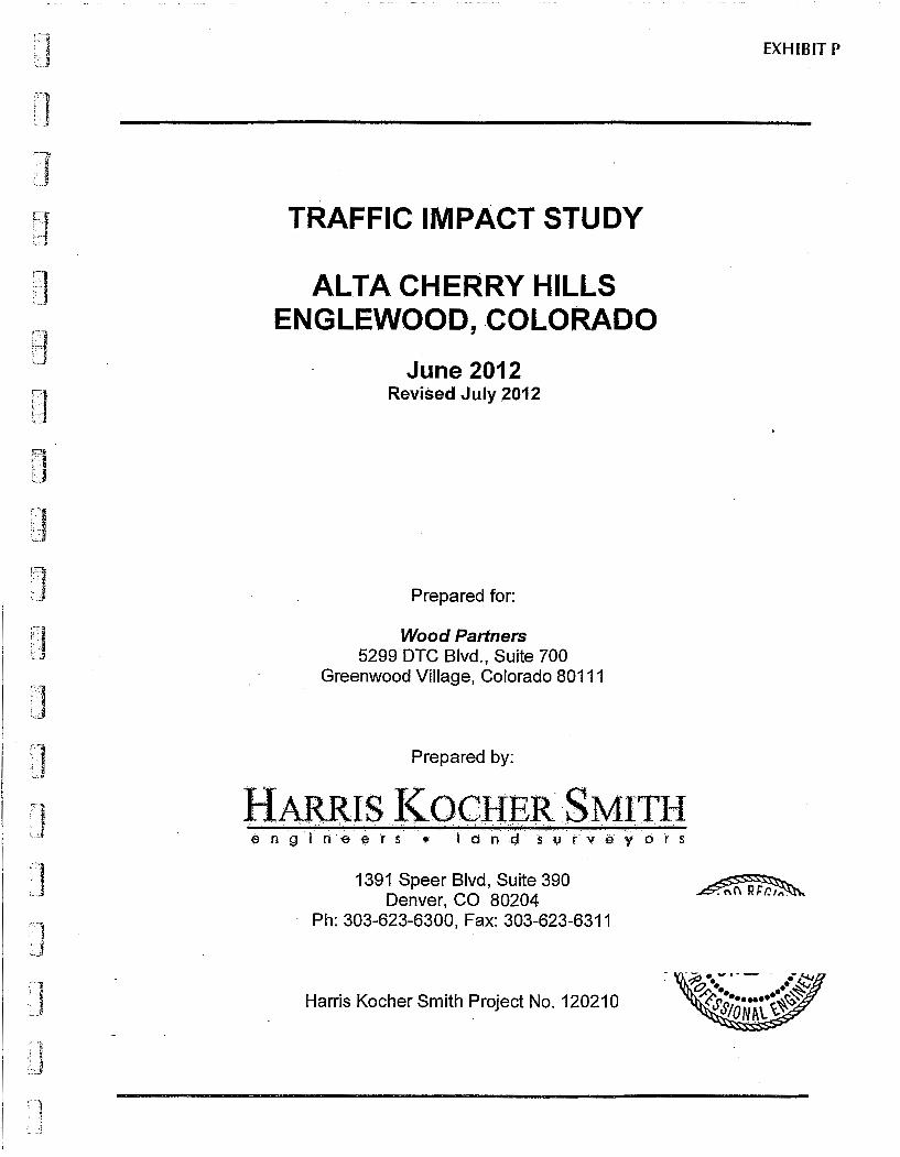
']
:l ,j
TRAFFIC IMPACT STUDY
ALTA CHERRY HILLS ENGLEWOOD, COLORADO
June 2012 Revised July 2012
Prepared for:
Wood Partners 5299 DTC Blvd., Suite 700
Greenwood Village, Colorado 80111
Prepared by:
HARRIS !(OCHER SMITI~ ... ··. '• . . :··· .. . . ..... :·· . .. -, ... · ... ,_ .. · .. ·.· ..... · .. ·. .
EXHIBIT P
1391 Speer Blvd, Suite 390 ~ Denver, CO 80204 ~(\ R.r:~~
Ph: 303-623-6300, Fax: 303-623-6311
Harris Kocher Smith Project No. 120210

]
]
]
1 ]
]
]
] ~
]
] .I J
J
J
J
J f J
J
Alta Cherry Hills Englewood, Colorado Traffic Impact Study
TABLE OF CONTENTS
I. INTRODUCTION ................................................................................................................ 1 A. Project Overview ............................................................................................................. 1 B. Purpose of Study ............................................................................................................. 1 C. Study Area ...................................................................................................................... 1
II. EXISTING CONDITIONS ................................................................................................... 2 A. Existing Traffic Volumes .................................................................................................. 2 B. Existing Roadway System ............................................................................................... 2
Ill. BACKGROUND TRAFFIC .................................................................................................. 5 A. Background Traffic Volumes ........................................................................................... 5 B. Background Traffic Operational Analysis ......................................................................... 5
IV. PROJECT DEVELOPMENT ............................................................................................... 6 A. Trip Generation ............................................................................................................... 6 B. Trip Distribution ............................................................................................................... 6 C. Trip Assignment ............................................................................................................... 6
V. TOTAL TRAFFIC ............................................................................................................... 6 VI. PROJECT ANALYSIS ........................................................................................................ ?
A. Operational Analysis ....................................................................................................... 7 B. Auxiliary Lane/Queuing Analysis ..................................................................................... 9 ·
VII. SUMMARY/CONCLUSIONS ............................................................................................ 10
i HAR.rus KOCHER SMITH

1 . j
"I J
J
]
:'}1
j
Alta Cherry Hills Englewood, Colorado Traffic Impact Study
LIST OF TABLES
1. Summary of Results - Intersection Capacity Analysis ....................................... 11 2. Trip Generation Summary ................................................................................... 6
APPENDIX "A" -LIST OF FIGURES A-1 Vicinity Map A-2 Conceptual Site Plan A-3 2012 Existing Traffic Volumes A-4 2015 Background Traffic Volumes A-5 2030 Background Traffic Volumes A-6 2012 Existing Traffic Operational Conditions A-7 2015 Background Traffic Operational Conditions A-8 2030 Background Traffic Operational Conditions A-9 Site Generated Trip Distribution A-1 0 Site Generated Trip Assignment A-11 2015 Total Traffic Volumes A-12 2030 Total Traffic Volumes A-13 2015 Total Traffic Operational Conditions A-14 2030 Total Traffic Operational Conditions
APPENDIX "B"- 2012 EXISTING TRAFFIC VOLUME COUNTS
APPENDIX "C"- INTERSECTION CAPACITY ANALYSIS WORKSHEETS
APPENDIX "D"- SITE GENERATED TRIP DISTRIBUTION & ASSIGNMENT
ii HARRIS KOCHER SMJTH

l ]
]
l J ]
]
]
J
]
1 j
]
]
Alta Cherry Hills Englewood, Colorado Traffic Impact Study
I. INTRODUCTION
A. Project Overview Wood Partners is proposing to redevelop the Flood Middle School site with a 350 unit multifamily residential apartment complex to be known as Alta Cherry Hills. The site is comprised of two parcels totaling approximately 4.5 acres. The west parcel contains approximately 3.0 acres and is bounded on the north by US 285, on the east by South Lincoln Street, on the south by East Kenyon Avenue and on the west by South Broadway. The east parcel contains approximately 1.5 acres and is bounded on the north by existing residential properties, on the east by South Sherman Street, on the south by East Kenyon Avenue and on the west by South Lincoln Street. The subject property lies within the jurisdictional limits of the City of Englewood, Colorado and is currently zoned MU-R-3-B and R-2-8. The developers are currently in the process of rezoning the property to PUD in order to accommodate the proposed multi-family development. Direct vehicular access to each parcel-ef-t-he subject property will be via proposed driveway intersections on South Lincoln Street north of East Kenyon Avenue. Off-street parking for the development will be provided by parking structures internal to the site for each parcel.
The location of the subject property is graphically depicted in Figure A-1. Figure A-2 graphically depicts a conceptual site plan for the property and provides the basis for conducting the traffic impact study.
B. Purpose of Study The purpose of this study is to evaluate and provide recommendations to mitigate the impact of the vehicular trips projected to be generated by the proposed development on the adjacent ·roadway system. The study includes 2015 "Short Range" (year of anticipated buildout) and 2030 "Long Range" analysis horizons.
This study was performed in accordance with City of Englewood criteria for preparing traffic impact studies.
C. Study Area The study area encompasses the existing roadway system in the vicinity of the project site. Specifically, the following roadway segments and intersections are evaluated:
Study Area Roadways: • South Broadway between East Kenyon Avenue and US 285 • East Kenyon Avenue between South Broadway and South Logan Street • South Lincoln Street north of East Kenyon Avenue • South Sherman Street between East Kenyon Avenue and US 285 • South Logan Street between East Kenyon Avenue and US 285 • US 285 between So!.!th Logan Street and South Sherman Street
Study Area Intersections: • East Kenyon Avenue/South Broadway • East Kenyon Avenue/South Lincoln Street • East Kenyon Avenue/South Sherman Street • East Kenyon Avenue/South Logan Street • US 285/South Logan Street • US 285/South Sherman Street • US 285 Westbound Ramps/South Broadway • US 285 Eastbound Ramps/South Broadway
Page 1 of11 HARRis KOCHER SMITH ·e: n g i n e e r·.s • l.a n d ·5 u' r v e· "{ ·c r·s
l ]
]
]
J
]
]
l ]
1
J 1 J
i J
Alta Cherry Hills Englewood, Colorado Traffic Impact Study
II. EXISTING CONDITIONS
A. Existing Traffic Volumes Existing (2012) peak hour intersection turning movement traffic volume counts were collected· for this study at the following intersections in May of 2012:
• East Kenyon Avenue/South Broadway • East Kenyon Avenue/South Lincoln Street • East Kenyon Avenue/South Sherman Street • East Kenyon Avenue/South Logan Street • US 285/South Logan Street • US 285/South Sherman Street • US 285 Westbound Ramps/South Broadway • US 285 Eastbound Ramps/South Broadway
Existing 24-hour directional traffic volume counts were collected for this study at the following locations in 2012:
o East Kenyon Avenue east of South Broadway (May 2012) • South Logan Street north of East Kenyon Avenue (May 2012) • South Broadway north of East Kenyon Avenue (July 2012) • US 285 east of South Logan Street (July 2012)
A summary of the existing (2012) peak hour intersection turning movement traffic volume counts and 24-hour"directional traffic volume counts are graphically illustrated in Figure A-3. Detailed traffic volume count data is provided in Appendix "B" ..
B. Existing Roadway System The existing transportation network in the vicinity of the subject property is graphically illustrated in Figure A-1. There are no planned major roadway improvements in the area for the foreseeable future that would alter the existing roadway network. The following narrative provides a description of the study area roadways and associated intersections:
Study Area Roadways: • South Broadway - Broadway is a principal north-south transportation link serving the
Denver area between downtown Denver and Highlands Ranch. In the vicinity of the study area South Broadway is a four-lane major arterial roadway providing north-south connectivity and direct access to adjacent properties. The roadway section consists of two travel lanes in each direction with a raised center median, on-street parking and attached sidewalks. The posted speed limit is 35mph south of East Kenyon Avenue and 30m ph north of East Kenyon Avenue.
• East Kenyon Avenue - East Kenyon Avenue between South Broadway and South Logan Street is an east-west two-lane collector roadway providing direct property access and connectivity to adjacent transportation corridors. The roadway section ·consists of one travel lane in each direction with on-street parking and attached sidewalks. The posted speed limit is 30mph.
• South Lincoln Street - South Lincoln Street north of East Kenyon Avenue is a northsouth two-lane local roadway providing direct access to the abutting residential properties. The roadway section consists of one travel lane in each direction with on-
Page 2 of 11 HARRis KocHER SMJTH ·e··n·gi'r.'ee'fs • 'i.ontl iUrv·eyrir)

1 j
]
1 J
1 .5I
1 .~
j
Alta Cherry Hills Englewood, Colorado Traffic Impact Study
street parking and attached sidewalks. The roadway terminates in a cul-de-sac on the north end. The posted speed limit is 30mph.
• South Sherman Street - South Sherman Street between East Kenyon Avenue and US 285 is a north-south two-lane local roadway providing direct access to the abutting residential properties as well as access to US 285. The roadway section consists of one travel lane in each direction with on-street parking and attached sidewalks. The posted speed limit is 30mph.
• South Logan Street - South Logan Street -between East Kenyon Avenue and US 285 is a north-south two-lane major collector roadway providing direct access to the abutting residential properties as well as north-south connectivity to the surrounding neighborhoods. The roadway section consists of one travel lane in the northbound direction, two travel lanes in the southbound direction (the outside southbound lane becomes an exclusive right turn lane and ends at East Kenyon Avenue) and attached sidewalks. There is no on-street parking in this segment. The posted speed limit is 30m ph.
• US 285 - US 285 is a US highway under the jurisdiction of the Colorado Department of Transportation (COOT). The City of Englewood operates the traffic signals on US 285 within the city limits for COOT. US 285 serv~s as a principal transportation corridor for the southern Denver Metropolitan Area. Between South Logan Street and South Sherman Street US 285 is classified by COOT as a category "B" Non-Rural Arterial (NRB). The roadway section consists of three travel lanes in each direction with a raised center median and attached sidewalks. The posted speed limit is 35mph.
Study Area Intersections: • East Kenyon Avenue/South Broadway - The East Kenyon Avenue South Broadway
intersection is a four-legged intersection under traffic signal control with a 120 second cycle length during the peak hours. The east leg of the intersection has one shared left turn/through/right turn lane on the westbound approach and one eastbound departure lane. The west leg of the intersection has one shared left turn/through/right turn lane on the eastbound approach and one westbound departure lane. The north leg of the intersection has one shared through/right turn lane, one through lane and one left turn lane with permitted phasing on the southbound approach and two northbound departure lanes. The south leg of the intersection has one shared through/right turn lane, one through lane and one left turn lane with permitted phasing on the northbound approach and two southbound departure lanes.
• East Kenyon Avenue/South Lincoln Street - The East Kenyon Avenue/South Lincoln Street intersection is a. four-legged intersection with stop sign control on the northbound and southbound approaches. The east leg of the intersection has one shared left turn/through/right turn lane on the westbound approach and one eastbound departure lane. The west leg of the intersection has one shared left turn/through/right turn lane on the eastbound approach and one westbound departure lane. The north leg of the intersection has one shared left turn/through/right turn lane on the southbound approach and one northbound departure lane. The south leg of the intersection has one shared left turn/through/right turn lane on the northbound approach and one southbound departure lane.
• East Kenyon Avenue/South Sherman Street- The East Kenyon Avenue/South Sherman Street intersection is a four-legged intersection with all-way stop sign control. The east
Page 3 of 11 HARRis KocHER SMITH

l ]
]
]
'i J
]
]
]
]
Alta Cherry Hills Englewood, Colorado Traffic Impact Study
leg of the intersection has one shared left turn/through/right turn lane on the westbound approach and one eastbound departure lane. The west leg of the intersection has one shared left turn/through/right turn lane on the eastbound approach and one westbound departure lane. The north leg of the intersection has one shared left turn/through/right turn lane on the southbound approach and one northbound departure lane. The south leg of the intersection has one shared left turn/through/right turn lane on the northbound approach and one southbound departure lane.
• East Kenyon Avenue/South Logan Street - The East Kenyon Avenue/South Logan Street intersection is a four-legged intersection with stop sign control on the eastbound and westbound approaches. The east leg of the intersection is a gravel driveway and has one shared left turn/through/right turn lane on the westbound approach and one eastbound departure lane. The west leg of the intersection has one shared left turn/through/right turn lane on the eastbound approach and one westbound departure lane. The north leg of the intersection has one shared left turn/through lane and one right turn lane on the southbound approach and one northbound departure lane. The south leg of the intersection has one shared left turn/through/right turn lane on the northbound approach and one southbound departure lane.
• US 285/South Logan Street - The US 285/South Logan Street intersection is a fourlegged intersection under traffic signal control with a 120 second cycle length during the peak hours. The east leg of the intersection has a channelized free right turn lane, three through lanes and one protected/permitted left turn lane on the westbound approach and three eastbound departure lanes. The west leg of the intersection has a channelized free right turn lane, three through lanes and one protected/permitted left turn lane on the eastbound approach and three westbound departure lanes. The north leg of the intersection has a channelized free right turn lane, two through lanes and one protected/permitted left turn lane on the southbound approach and one northbound departure lane. The south leg of the intersection has a channelized free right turn lane, one through lane and one protected/permitted left turn lane on the northbound approach and two southbound departure lanes.
• US· 285/South Sherman Street - The US 285/South Sherman Street intersection is. a four-legged intersection under traffic signal control with a 120 second cycle length during the peak hours. The east leg of the intersection has one shared through/right turn lane and two through lanes on the westbound approach and three eastbound departure lanes. The west leg of the intersection one shared through/right turn lane, two through lanes and one protected/permitted left turn lane on the eastbound approach and three westbound departure lanes. The north leg of the intersection has one shared left turn/through/right turn lane on the southbound approach and one northbound departure lane. The south leg of the intersection has one shared left turn/through/right turn lane on the northbound approach and one southbound departure lane.
• US 285 Westbound Ramps/South Broadway - The US 285 Westbound Ramps/South Broadway intersection is a typical diamond interchange ramp terminus at an arterial roadway. The intersection is under traffic signal control with a 120 second cycle length during the peak hours. The east leg of the intersection has one left turn lane and one shared through/right turn lane on the westbound approach. The west leg of the intersection has two westbound departure lanes. The north leg of the intersection has two through lanes and one right turn lane on the southbound approach and two northbound departure lanes. The south leg of the intersection has one left turn lane and two through lanes on the northbound approach and two southbound departure lanes.
Page 4 of 11 HARRIS KOCHER SMITH ·e n g i r. e · C T s · • 1 o n d · ~ · u r· v e y c r s

'l
j
]
]
] i'JJ
l :.J
]
j
] ~
]
]
l J
l J
I j
Alta Cherry Hills Englewood, Colorado Traffic Impact Study
• US 285. Eastbound Ramps/South Broadway - The US 285 Eastbound Ramps/South Broadway intersection is a typical diamond interchange ramp terminus at an arterial roadway. The intersection is under traffic signal control with a 120 second cycle length during the peak hours. The east leg of the intersection has one eastbound departure lane. The west leg of the intersection has dual left turn lanes and. a shared through/right turn lane on the eastbound approach. The north leg of the intersection has one left turn lane and two through lanes on the southbound approach and two northbound departure lanes. The south leg of the intersection has two through lanes and one right turn lane on the northbound approach and two southbound departure lanes.
Ill. BACKGROUND TRAFFIC
A. Background Traffic Volumes Background traffic forecasts for the 2015 and 2030 analysis horizons were developed for this study utilizing the traffic volume counts collected and the following assumptions:
• Traffic volume growth rates for South Broadway, East Kenyon Avenue, South Lincoln Street, South Sherman Street and South Logan Street are assumed to be 0.5% annually. This is due to the area being mature and largely builtout. Traffic growth for the minor streets would come through redevelopment in the surrounding neighborhood to higher density residential land uses. Traffic growth on· South Broadway will come from regional growth.
• Traffic volume growth for US 285 in the vicinity of the study area was taken from the COOT traffic statistics data base (detailed excerpt for this segment of US 285 is included in Appendix "B"). For this segment of US 285 the COOT 20 growth factor is projected to be 1.22 and the AADT in 2011 was 55,000vpd.
• Peak hour distribution of approach traffic (left turn, through, right turn) will remain constant through the 2030 analysis horizon.
Figures A-4 and A-5 graphically illustrate the projected background traffic volumes for the 2015 and 2030 anC~Iysis horizons, respectively.
B. Background Traffic Operational Analysis In order to establish a base condition in which to evaluate the impact of the traffic generated by the proposed Alta Cherry Hills development on the study area intersections, peak hour capacity analyses were performed for the 2012 existing and the 2015 and 2030 analysis horizons projected background traffic conditions. These analyses utilize the methodologies contained in the Highway Capacity Manual 2000 employing Synchro 6.0 software and result in a qualitative measure of the operational characteristics of the intersection described by a letter designation ranging from "A" to "F" known as "Level of Service" (LOS). LOS "A" represents ideal free flow operating conditions, whereas LOS "F" represents excessive congestion and delay. Unsignalized intersection capacity analysis reports a LOS designation for each impeded intersection movement. Signalized intersection capacity analysis reports the overall LOS designation for the intersection as well as for each lane group. LOS "0" is considered the minimum acceptable standard of operation. The following study area intersections were analyzed for the 2012 existing and the 2015 and 2030 analysis horizons background traffic conditions:
• East Kenyon Avenue/South Broadway • East Kenyon Avenue/South Lincoln Street • East Kenyon Avenue/South Sherman Street • East Kenyon Avenue/South Logan Street
Page 5 of 11 HARRis KocHER.SMITH
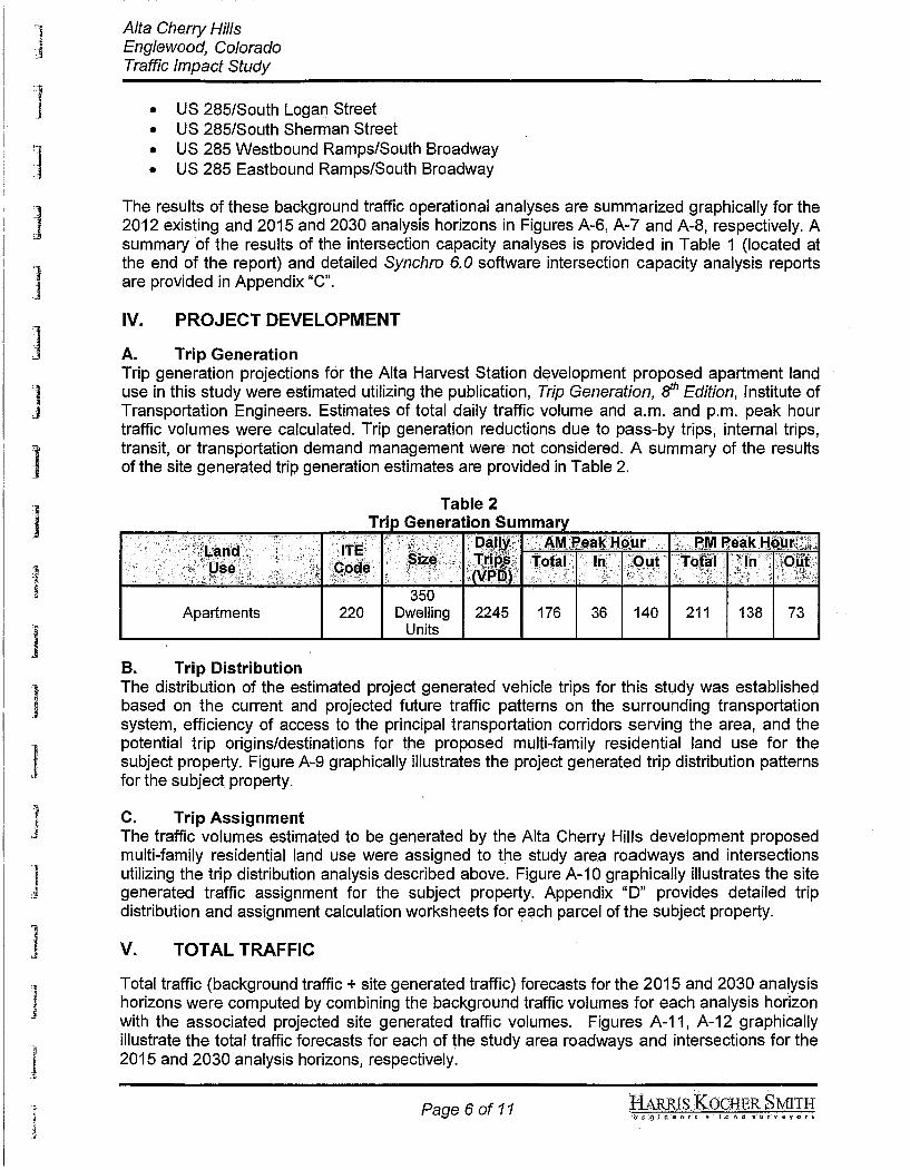
]
]
']· ..
]
1 J
]
J
]
Alta Cherry Hills Englewood, Colorado Traffic Impact Study
• US 285/South Logan Street • US 285/South Sherman Street • US 285 Westbound Ramps/South Broadway • US 285 Eastbound Ramps/South Broadway
The results of these background traffic operational analyses are summarized graphically for the 2012 existing and 2015 and 2030 analysis horizons in Figures A-6, A-7 and A-8, respectively. A summary of the results of the intersection capacity analyses is provided in Table 1 (located at the end of the report) and detailed Synchro 6. 0 software intersection capacity analysis reports are provided in Appendix "C".
IV. PROJECT DEVELOPMENT
A. Trip Generation Trip generation projections for the Alta Harvest Station development proposed apartment land use in this study were estimated utilizing the publication, Trip Generation, 81
h Edition, Institute of Transportation Engineers. Estimates of total daily traffic volume and a.m. and p.m. peak hour traffic volumes were calculated. Trip generation reductions due to pass-by trips, internal trips, transit, or transportation demand management were not considered. A summary of the results of the site generated trip generation estimates are provided in Table 2.
Table 2 Trip Generation Summary
350 Apartments 220 Dwelling 2245 176 36 140 211 138 73
Units
B. Trip Distribution The distribution of the estimated project generated vehicle trips for this study was established based on the current and projected future traffic patterns on the surrounding transportation system, efficiency of access to the principal transportation corridors serving the area, and the potential trip origins/destinations for the proposed multi-family residential land use for the subject property. Figure A-9 graphically illustrates the project generated trip distribution patterns for the subject property.
C. Trip Assignment The traffic volumes estimated to be generated by the Alta Cherry Hills development proposed multi-family residential land use were assigned to the study area roadways and intersections utilizing the trip distribution analysis described above. Figure A-1 0 graphically illustrates the site generated traffic assignment for the subject property. Appendix "D" provides detailed trip distribution and assignment calculation worksheets for each parcel of the subject property.
v. TOTAL TRAFFIC
Total traffic (background traffic+ site generated traffic) forecasts for the 2015 and 2030 analysis horizons were computed by combining the background traffic volumes for each analysis horizon with the associated projected site generated traffic volumes. Figures A-11, A-12 graphically illustrate the total traffic forecasts for each of the study area roadways and intersections for the 2015 and 2030 analysis horizons, respectively.
Page 6 of 11 lfARRISKOCHER SMITH

l j
]
]
]
]
1
]
j
J J
]
Alta Cherry Hills Englewood, Colorado Traffic Impact Study
VI. PROJECT ANALYSIS
A. Operational Analysis In order to evaluate the impact of the proposed land use for the subject property on the. study area roadway system, peak hour intersection capacity analyses for total traffic conditions were performed for the 2015 and 2030 analysis horizons at each of the study area intersections listed below:
• East Kenyon Avenue/South Broadway • East Kenyon Avenue/South Lincoln Street • East Kenyon Avenue/South Sherman Street • East Kenyon Avenue/South Logan Street • US 285/South Logan Street • US 285/South Sherman Street • US 285 Westbound Ramps/South Broadway • US 285 Eastbound Ramps/South Broadway • South Lincoln Street/Proposed West Building Access Drive • South Lincoln Street/Proposed East Building Access Drive
All signalized intersections were analyzed utilizing their current individual peak hour timing and phasing plans as provided by the City of Englewood.
A narrative of the summary of these analyses and comparison to background traffic conditions for the 2015 and 2030 analysis horizons is provided below. The results of these total traffic operational analyses are summarized graphically for the 2015 and 2030 analysis horizons in Figures A-13 and A-14, respectively. A summary of the results of the intersection capacity analyses is provided in Table 1 and detailed Synchro 6.0 software intersection capacity analysis reports are provided in Appendix "C".
Study Area Intersections: • East Kenyon Avenue/South Broadway - The East Kenyon Avenue/South Broadway
intersection is anticipated to operate at acceptable levels of service (LOS "D" or better) during the a.m. and p.m. peak hour periods under either background traffic or total traffic conditions for both the 2015 c;tnd 2030 analysis horizons under traffic signal control.
• East Kenyon Avenue/South Lincoln Street - The East Kenyon Avenue/South Lincoln Street intersection is anticipated to operate at acceptable levels of service during the a.m. and p.m. peak hour periods under either background traffic or total traffic conditions for both the 2015 and 2030 analysis horizons with the existing two-way stop sign control on the South Lincoln Street approaches.
• East Kenyon Avenue/South Sherman Street- The East Kenyon Avenue/South Sherman Street intersection is anticipated to operate at acceptable levels of service during the a.m. and p.m. peak hour periods under either background traffic or total traffic conditions for both the 2015 and 2030 analysis horizons with the existing all-way stop sign control.
• East Kenyon Avenue/South Logan Street - The East Kenyon Avenue/South Logan Street intersection is anticipated to operate at acceptable levels of service during the a.m. and p.m. peak hour periods under either background traffic or total traffic conditions for both the 2015 and 2030 analysis horizons with the existing two-way stop sign control on the East Kenyon Avenue approaches.
Page 7 of 11 ' HARRIS KOCHER SMITH
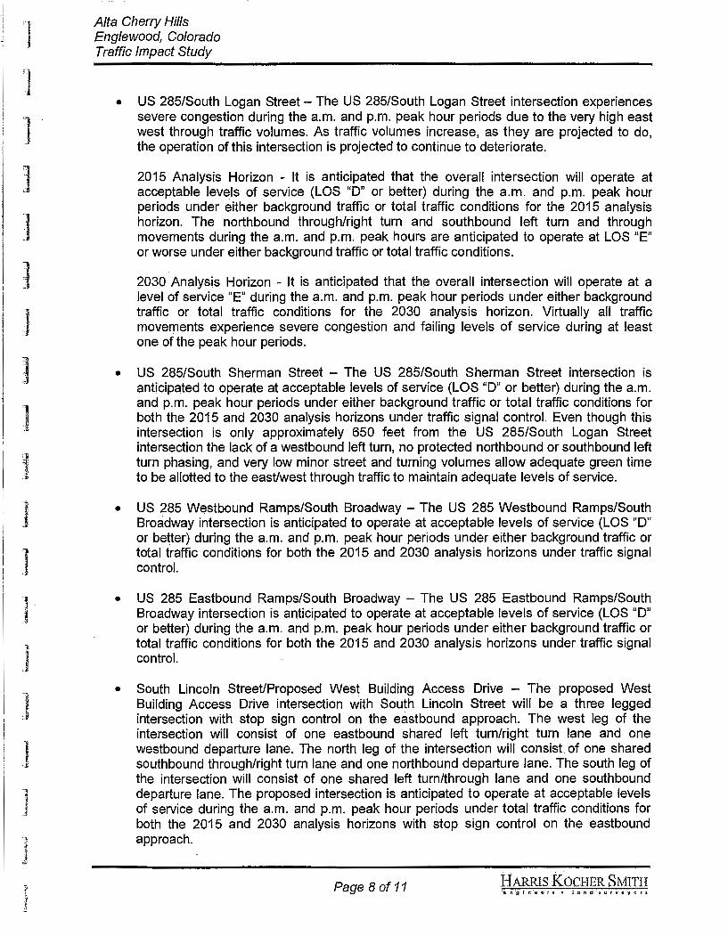
]
]
]
]
]
]
]
]
J
Alta Cherry Hills Englewood, Colorado Traffic Impact Study
• US 285/South Logan Street - The US 285/South Logan Street intersection experiences severe congestion during the a.m. and p.m. peak hour periods due to the very high east west through traffic volumes. As traffic volumes increase, as they are projected to do, the operation of this intersection is projected to continue to deteriorate.
2015 Analysis Horizon - It is anticipated that the overall intersection will operate at acceptable levels of service (LOS "D" or better) during the a.m. and p.m. peak hour periods under either background traffic or total traffic conditions for the 2015 analysis horizon. The northbound through/right turn and southbound left turn and through movements during the a.m. and p.m. peak hours are anticipated to operate at LOS "E" or worse under either background traffic or total traffic conditions.
2030 Analysis Horizon - It is anticipated that the overall intersection will operate at a level of service "E" during the a.m. and p.m. peak hour periods under either background traffic or total traffic conditions for the 2030 analysis horizon. Virtually all traffic movements experience severe congestion and failing levels of service during at least one of the peak hour periods.
• US 285/South Sherman Street - The US 285/South Sherman Street intersection is anticipated to operate at acceptable levels of service (LOS "D" or better) during the a.m. and p.m. peak hour periods under either background traffic or total traffic conditions for both the 2015 and 2030 analysis horizons under traffic signal control. Even though this intersection is only approximately 650 feet from the US 285/South Logan Street intersection the lack of a westbound left turn, no protected northbound or southbound left turn phasing, and very low minor street and turning volumes allow adequate green time to be allotted to the east/west through traffic to maintain adequate levels of service.
• US 285 Westbound Ramps/South Broadway - The US 285 Westbound Ramps/South Broadway intersection is anticipated to operate at acceptable levels of service (LOS "D" or better) during the a.m. and p.m. peak hour periods under either background traffic or total traffic conditions for both the 2015 and 2030 analysis horizons under traffic signal control.
• US 285 Eastbound Ramps/South Broadway - The US 285 Eastbound Ramps/South Broadway intersection is anticipated to operate at acceptable levels of service (LOS "D" or better) during the a.m. and p.m. peak hour periods under either background traffic or total traffic conditions for both the 2015 and 2030 analysis horizons under traffic signal control.
• South Lincoln Street/Proposed West Building Access Drive - The proposed West Building Access Drive intersection with South Lincoln Street will be a three legged intersection with stop sign control on the eastbound approach. The west leg of the intersection will consist of one eastbound shared left turn/right turn lane and one westbound departure lane. The north leg of the intersection will consist of one shared southbound through/right turn lane and one northbound departure lane. The south leg of the intersection will consist of one shared left turn/through lane and one southbound departure lane. The proposed intersection is anticipated to operate at acceptable levels of service during the a.m. and p.m. peak hour periods under total traffic conditions for both the 2015 and 2030 analysis horizons with stop sign control on the eastbound approach.
Page 8 of 11 iiARRis KocHER SMITH

]
]
··~ j
;I j
Alta Cherry Hills Englewood, Colorado Traffic Impact Study
• South Lincoln Street/Proposed East Building Access Drive -The proposed East Building Access Drive intersection with South Lincoln Street will be a three legged intersection with stop sign control on the westbound approach. The east leg of the intersection will consist of one westbound shared left turn/right turn lane and one eastbound departure lane. The north leg of the intersection will consist of one shared southbound left turn/through lane and one northbound departure lane. The south leg of the intersection will consist of one shared through/right turn lane and one southbound departure lane. The proposed intersection is anticipated to operate at acceptable levels of service during the a.m. and p.m. peak hour periods under total traffic conditions for both the 2015 and 2030 analysis horizons with stop sign control on the eastbound approach.
B. Auxiliary Lane/Queuing Analysis An ·analysis of the East Kenyon Avenue/South Broadway and the US 285/South Logan Street intersections were conducted to evaluate the adequacy of the existing intersection approach auxiliary lanes. This analysis is based on AASHTO and COOT State Highway Access Code criteria and the 2030 analysis horizon total traffic volumes and verified against a Poisson analysis for a 95 percentile queue. The design vehicle length is taken to be 25 feet. A summary of the results of this analysis is as follows:
• East Kenyon Avenue/South Broadway intersection Westbound Intersection Approach -The projected 2030 analysis horizon peak hour total traffic volumes for the westbound intersection approach is 157vph during the a.m. peak hour and 118vph during the p.m. peak hour. Based on these volumes and the modeled traffic signal timing the expected queue length on the westbound intersection approach will be approximately 200 feet during the a.m. peak hour and 150 feet during the p.m. peak hour.
• East Kenyon Avenue/South Broadway intersection Southbound Left Turn - The projected 2030 analysis horizon peak hour total traffic volumes for the southbound left turn is 21vph during the a.m. peak hour and 74vph during the p.m. peak hour. Based on these volumes and the modeled traffic signal timing with permitted only left turns (permitted only left turns assumes that the effective green time is the yellow plus all red interval only) the expected queue length for the southbound left turn will be approximately 50 feet during the a.m. peak hour and 125 feet during the p.m. peak hour. The actual vehicle storage provided is approximately 150 feet. Therefore, the existing southbound left turn lane should be adequate to accommodate the projected southbound left turn volume through the 2030 analysis horizon.
• East Kenyon Avenue/South Broadway intersection Northbound Left Turn - The projected 2030 analysis horizon peak hour total traffic volumes for the northbound left turn is 127vph during the a.m. peak hour and 72vph during the p.m. peak hour. Based on these volumes and the modeled traffic signal timing with permitted only left turns the expected queue length for the northbound left turn will be approximately 200 feet during the a.m. peak hour and 150 feet during the p.m. peak hour. The actual vehicle storage provided is approximately 200 feet. Therefore, the existing northbound left turn lane should be adequate to accommodate the projected northbound left turn volume through the 2030 analysis horizon.
• US 285/South Logan Street intersection Westbound Left Turn - The projected 2030 analysis horizon peak hour total traffic volumes for the westbound left turn is 55vph during the a.m. peak hour and 112vph during the p.m. peak hour. Based on these volumes and the modeled traffic signal timing the expected queue length for the westbound left turn will be approximately 100 feet during the a.m. peak hour and 175
Page 9 of 11 HARRis KOCHER SMITH engineer's. l.a·nd'~'urveycr's

1
]
J ]
1 j
]
]
I
J
1
' I l -'
Alta Cherry Hills Englewood, Colorado Traffic Impact Study
feet during the p.m. peak hour. The actual vehicle storage provided is approximately 175 feet. Therefore, the existing westbound left turn lane should be adequate to accommodate the projected northbound left turn volume through the 2030 analysis horizon.
• US 285/South Logan Street intersection Northbound Through/Right Turn Lane - The projected 2030 analysis horizon peak hour total traffic volumes for the northbound through/Right Turn lane is 441vph during the a.m. peak hour and 309vph during the p.m. peak hour. Based on these volumes and the modeled traffic signal timing the expected queue length for the northbound through lane will be approximately 550 feet during the a.m. peak hour and 300 feet during the p.m. peak hour. These vehicle queues will effectively block northbound left turn traffic from entering the left turn auxiliary lane and the p.m. peak hour queue will extend south of the East Jefferson Drive intersection.
• US 285/South Logan Street intersection Northbound Left Turn Lane - The projected 2030 analysis horizon peak hour total traffic volumes for the northbound left turn lane is 141vph during the a.m. peak hour and 63vph during the p.m. peak hour. Based on these volumes and the modeled traffic signal timing the expected queue length for the northbound left turn lane will be approximately 225 feet during the a.m. peak hour and 75 feet during the p.m. peak hour. The actual vehicle storage provided is approximately 160 feet. Therefore, the existing northbound left turn lane will be inadequate to accommodate the projected 2030 analysis horizon northbound left turn volume.
VII. SUMMARY/CONCLUSIONS
Wood Partners is proposing to redevelop the Flood Middle School site with a 350 unit multifamily residential apartment complex to be known as Alta Cherry Hills. The site is comprised of two parcels totaling approximately 4.5 acres. The subject property lies within the jurisdictional limits of the City of Englewood, Colorado and is currently zoned MU-R-3-B and R-2-B. The developers are currently- in the process of rezoning the property to PUD in order to accommodate the proposed multi-family development. Direct vehicular access to each parcel of the subject property will be via proposed driveway intersections on South Lincoln Street north of East Kenyon Avenue. Off-street parking for the development will be provided by parking structures internal to the site for each parcel.
The 350 unit apartment complex is projected to generate approximately 2,245 daily vehicle trips of which approximately 176 will be generated during the a.m. peak hour and approximately 211 will be generated during the p.m. peak hour. ·
Based on the results of the analyses performed herein, the proposed Alta Cherry Hills development can be accommodated by the study area roadways and intersections in their current configurations without modification without creating significant impacts to the study area roadways through the 2030 analysis horizon.
Page 10 of11 HARRJS KoCHER SMITH
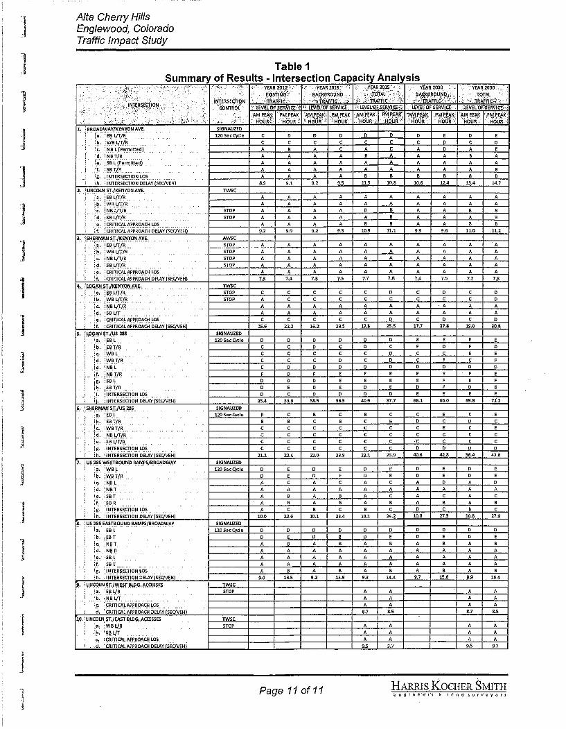
--~
J
'l J
1 1 ] ] ]
]
] _j
J
]
J
Alta Cherry Hills Englewood, Colorado Traffic Impact Study
Table 1 Summary of Results - Intersection Capacity Analysis
•.'.
1, 1 BROADWAY/KENYON AVE. ( :·· ::~; . ~·~~ 0/~:.-:: :··· .. . . . ), 'W.Bl/I/fL .... :c. : NB L (Permitted)
;:-: 'fM;~~~~~~) -_ - ; :j: --~~J/R_ ... - ·-
i g. '[N]'EB5I£!'J!?~.LQS ___ -!h. ; INTERSECfiON DELAY (SEC/VEH)
2. : ~IN~OLN_ H-/~_ENYON AVE._ i ;e: :_EB.l/T/R + 'WBL/T/R
:_ ~- : f'!sj/:i!li -~- :sa_l/T/R __ __ 'e. :cRITICALAPPROAa-i LOS ;f. 'i:'iili'liALAPPiioAOi oirJ..vise&vEfli
3._ ~~~-1~M~:0;~~ypN)\V~'-
>= i \Ji!.B .1/T/~ . i~- 'NBL/T/R :~-- '58 Lil'tii'
. ! e. ffiiriCALAPPROACH LOS : :f. iC:Riri6\i:i>.PirioiiCil DELAY isECtVEfH
4. ; LOGAN ST./KENYON AVE. ·--··:1~:·-:~~i/iA:---- -·
ib. :WB l/T/R
. !c. !_ ..• SNBBL/lrcT)~: .. !d, : ~-- :CRITICAL APPROACH LOS
; .. if. icrilrleALAPP'rioA"Cii.oi:iAv 1siC!vefil
5. i LOGAN ST./US 285 r··~--~~~·- ·i:e.~·.i. _··-- ·
\.b. _E~ T/~ !c. :\N_B L_ . :d: :)'!_B.!/R.
_!,~. 'NB_L . :t. 'NBT/R is- :sii L- ·
i~· i-i~Tv:~~q)o~ LQS .. . . . (j. : INTERSECfiON DELAY (SEC/VEHI
~- \US 285 WESTBOUND RAMPS/BROADWAY ; -- ~~ :wai. -- · -- ·-- · -- · ·· ii,. i0.B_ 'i-tfl >c;. 'NBL
.- !d. •ri8'T-' i. ~~:
:f, :ss.R l g_._ ; INTERSECfiON LOS
· - , h. , i'Ni-erisEi::i-iciN oei.AY isEcivEi-r\ ~- 'US 285 EASTBOUND RAMPS/BROADWAY :· . ra.··,eaL --- ....... -- - --··-
1 b~ )EBT
!c. lN.~T ld:_!NBR :e.· iSB'i.·
·· i.~- '~B T 'g. : INTERSECfiON LOS :h. iiNTERsec'rioN-oELAY isic/vEHl
9. luNCOLN ST./WEST BLDG. ACCESSES · · ~~- 'es_r,i~ - --- - · ·
:~: if\I_B,.l/! . i c. 'CRITICAL APPROACH LOS 'd. =cRITicAL APPRoAcH DELAY lsEc/iieHl
10. 'LINCOLN ST./EAST BLDG. ACCESSES .. . a. 'wa[fR - --- . -
·~- 'sa Lj-i' :c. !CRITICAL APPROACH LOS
. :d. cRITiCAL APPROAcH DELAY is-EC/VEHi
-•• ;. t · • ·c.,.,.,yE,IIR 2012'- · '"I·' ' YEA_R 2015;• ,., ' YEAR 2015' YEAR 2030 VEI\~.2030 ' ·,- - ' . exis'nNG'{. ·' BACKGROUND '-;,'TOTAL eiii:Ks'itobND : :rbm .
INrERsEcridN • i-RAFFit -, ,:,-:.,fRA~Fic · :<.- f~:.:r'ri1d ,, 'iriAFFit --· ;iiAFFr2:~ · _cgNTRq(. .'LEVEL OF SER\ilc:(·-~ ''·lEVEL'o~:sER)I_IcE i: :!·:U:VEL'QfSERVI!:E"~ .-·LEVEl OF $E~)/_tq:,•. _:Lf:VEU)F'SE~Yicf:
SIGNALIZED 120 Sec Cllcle
TWSC
STOP STOP
AWSC STOP STOP STOP STOP
TWSC STOP STOP
SIGNALI2ED 120 Sec Cllcle
SIGNALIZED 120SecCvcle
SIGNALIZED 120 Sec Cvcl e
SIGNALIZED 120 SecCIIcle
TWSC STOP
TWSC STOP
1'-~PE,<\~ 'PMPEAK' 'AMPEAK: );.ir}EAK AMPE,t\1( i>l\jlj_~K, )>.Mi>¢,A~ PMPEAK AM PEAk 'ii0~E6~ HOUR' .HOUR·' '-'H(j-J~' HOUR :•HOUR•-' HOUR'· ·:HOUR-- :iiou~>:, 'HOUR. -HOUR·
c c A
A A
A
A
8.9
A A A
A
A
9.2
A
A
A
A
A
7.~
c A A
A c
15.6
D c c c c
D
D D
35.4
c c c c
21.1
D D
A
A
A
A A
10.0
D
D
A A A A
A 9.0
D c
A A A A
9.1
A
A
A A
A
9.9
A
A
A
A A
7.4
c c A A
c 22.2
D c c c D D D
c 33.9
c
c c c c
22.4
c A
c 22.6
D
A A A
13.5
D
c A A A
A A
9.2
A A A
A
A
9.2
A
A
A
A
A
7.3
c c A
A
c 16.2
D D c c D
D D 0
38.5
B c c c c c
22.0
D D
A
A
A A
10.1
D D A A
A
A A
9.2
Page 11 of11
D
c c A A
A
A
9.S
A
A
A
A
A 9.5
A
A
A
A
A 7.5
c c A A
c 23.5
D c c D D
D 36.5
c
c c c c
23.9
c A
c 23.4
D
A A
A
13.9
D c A
A A
11.5
A
A
A
10.9
A
A A
A
A
7.7
c c A
A
c 17.3
D D c c D
D D
40.9
c c c c c
22.1
D D
A
A
A
A
10.1
D D
.A
A
A A A
9.3
A A A
8.7
A
A
A
9.5
D c c A A A
B
10.8
A
A
B
11.1
A
A A A
A
7.'{3
D c A
A D
25.5
D c D D D
D 37.7
c
c c c c
23.9
c A c
c 24.2
D
A
A
A
B 14.4
A
A
A
8.5
A
A
A
9.7
D
c A A
A A
10.6
A
A
A
A
A
9.3
A
A
A
A
A 7,4
c c A A
c 17.7
c c D
D
66.1
c D c c
-C
D 40.6
D
D A
A
A
A
10.8
D D A
A
A A
A 9.7
D D A
A
A
12.4
A
A
A
A
A
9.6
A
A
A
A A
7.5
D c A A
D 27.8
D c
D
66.0
c
c c D
42.8
D A
c
c 27.3
D
A
A
A
1S.6
D c A
A A
13.4
A
A
A
11.0
A A A A A
7.7
c
A A c
19.0
c D
D
69.8
0
0 36.4
D D A
A A
A
10.8
D A A A A A
9.9
A A A
8.7
A A A
9.5
D
E A
A
14.7
A
A
B
11.2
A
A
A
A
A 7,~
D D
A
A
D 30.8
D
D
7i.2
c
c c D
42.8
D A
c
c 27.9
D
A A A
16.4
A
A
A 8.5
A
A A
9.7
BARRIS KOCHER SMITH
!=·----;.. ~: ~
·,, j
:-'")
,J '~1
t ._j
--1 ~-::--1!
~1
''1 rj '~1 ~:--=: ' u
~] r-~~
d ~] \<-~.li
!L~ .•.. f \. .. ~
c:-1 u ':--) . . ~-"
.. .-1 'J :-;
i ..... 1/1
i d
·- 1 ~ !
.;;j
--~i
l' _j
~ -l ~1
A-1 A-2 A-3 A-4 A-5 A-6 A-7 A-8 A-9 A-10 A-11 A-12 A-13 A-14
APPENDIX "A"
Vicinity Map Conceptual Site Plan
FIGURES
2012 Existing TrafficVolumes 2015 Background Traffic Volumes 2030 Background Traffic Volumes 2012 Existing Traffic Operational Conditions 2015 Background Traffic Operational Conditions 2030 Background Traffic Operational Conditions Site Generated Trip Distribution Site Generated Trip Assignment 2015 Total Traffic Volumes 2030 Total Traffic Volumes 2015 Total Traffic Operational Conditions 2030 Total Traffic Operational Conditions

r-~
---j
,--1 \._
]
1 ' i! · •.. JI
} __j
l , ISSUE DATE: 04/19/12
DATE REVISION COMMENTS
ALTA CHERRY HILLS TRAFFIC IMPACT STUDY VICINITY MAP
NO CHANGES ARE TO BE MAllE TO THIS DRAWINGWITHOUTWruTTEN PERMISSIOW Of HARrus KOCHER SMITH.
1391 Speer Blvd., Suite 390 Denver, Colorado 80204
Phone (303) 623-6300 Fax (303) 623-6311
AOJRE
A-1

L~!·~~·:t~·J il~~:;:J r-·-· : ~~!W
r .,
~ L~~ c=..J ~ r· · ... ,.,1
""-""'--"'
FILEPATH: P: \120210\DOCUMENTS\TRAFFIC\FIGURES\A-2 SITE MAP.DWG LAYOUT: LAYOUTl NO XREFs · PLOTTED: FRI 06/01/12 9:44:31A BY: FRED DEAN
m
" rn z -< 0 z ~ rn z c m
~~~~ 1";;:; )> ~~~~"~ o I !:!J 1l !!!
"" N ~0
0 r c: m X 0 c: en m
5. BROADWAY
0 0 c:"C ~g ~r eg
5. LINCOLN STREET
N 0
(f) -....I
iJiJ )>)> O:;o m"' (j)z
G)
.j)l.
en' -f::! ;;om c:::U o"C -f)> c::O ;;u,:; mz
Gl
S.SHERMANSTREET ~ -r c -z G) ..1o.
ALTA CHERRY HILLS TRAFFIC IMPACT STUDY
C,...,;J .Gt._.~ c~ t:U~ ~.:.::J ~ ~ (l:JJ C.:J c:..J c:J
NO CHANGES ARE TO BE MADE TO THIS DRAWING WITHOUT WRITTEN PERMISSION OF HARRIS KOCHER SMITH.
Nen
to c -r c -z G) 1\)
CXl -f , (/) (]I ;;u. )> .a::-. iJ iJ c: ;;u ~ f;5; Q~~ m"' c:,.. (/)- ;;u '" zm
G.>.
CONCEPTUAL SITE PLAN
ISSUE DATE: 04/19/12 DATE I REVISION COMMENTS
:::r:: )> :s: "'0 c m z ~ m z c m
n'" :;::::as l 0) q
HA.ruus KocHER SMITE a n g I n a 8 r :i • I a n d s u r v 8 y o t. &
1391 Speer Blvd., Suite 3so oen•;er1 Colorado 80204 Phcne (303) 623~6300
Fax (303) 623·6311

'"'.J ' . ... _
116 (65l-4' 1681 (1166 ~
5 (22..,..
~ "<:!-'-'i'0 ...___. ...___. 'o~o
~t~
r:·l GRANT ST. ;J ~------+--................... __ _,
15 (15l-4' 480 (288 ~
1 (2..,..
~18 (51) .... 211 (514) -.o (2)
I BAO<C'IOOND mNFICVCl.tJI,IES.OWG lAYOUT: A-3
ALTA CHERRY HILLS TRAFFIC IMPACT STUDY
4 (6l-4' 14 12 ~ 13 ~12 ...
2012 EXISTING TRAFFIC VOLUMES
~51 (208) -+-513 (1259)
---- EXISTING ROADWAY
• • • • • • • • • • FUTURE ROADWAY
AM(PM) PEAK HOUR ~ XX(XX) TRAFFIC VOLUME (VPH)
~ TOTAL DAILY TRAFFIC
~- PROJECT SITE
~11 (20) .... 3 (18) --.r-6 (13)
~119 (206) ~168 (463) -..r-91 (137)
,..--... ,--... ,..--... 0 = Cl) r-- r-- c.o .___.. C'-1 .___..
C'J ~0 . "<:!- LO
t.n = r--
HAruus KocHER SMITH
1391 Speer Blvd., Suite 390 Denver, Colorado 80204
Phone {303) 623-6300 Fax {303) 623-6311
DSN'O BY: MEK CHK'O BY: MEK DRAWN BY: FRD JOB NUM: 120210
A-3
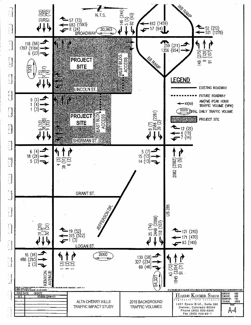
Cl :J
118 (66l.4--1707 (1184 ~
6 (23 ..
@~ ~~~
"lt------'J r1 ((3ll! !l ..... :t:j
. C'']i ·-·: ·, ·; ~- _..,
::as .......... 0)
NTS "<~- ,......._
"• N ~ ~57 (73) :;~>---~683 (1593) ~~~
r 612 (1459)
.-s7 (9~ ~52 (212) ~521 (1278) . Y 8 (~~OADWA~~ ~
-+--------,-t-~ ~ (211)~ 'I 1' 1356 (954)
5 (7l...4' 15 (13 ~ 14 (13 ..
LEGEND ---- EXISTING ROADWAY
· • • • • • • • • • • FUTURE ROADWAY
~ XX{XX) AM(PM) PEAK HOUR TRAFFIC VOLUME (VPH)
~TAL DAILY TRAFFIC VOLUME
. IIIIIIIV'dl PROJECT SITE
~12 (21) ~4 (19) ~7 (14)
'_] 1-----.... 1---•G•R•A•N•T•ST.·----#
9::' ~ ~ co
llt ggr:::' /1 ~~~
~19 {52) ~ ~~; ~121 (210) ~ 215 (522) j l ~ --171 ( 470)
] 1----~-~-~+--·-1 (~3)~~-------+-·-93-(140) 't~ 16 (16l~
488 (293 ~ . i
;J 2(3 .. ZIJ.I O::::> >-Z zw w> ~<(
130 (58l...4' 327 (234 ~
69 (46 ~
A-4 1391 Speer Blvd., Suite 390
Denver, Colorado 80204 Phone {303) 623-6300
Fax {303) 623·6311 . -~ L__J_ ____ __._ ______ -L,._ ______ .~..--__ ..;.,._ __ ....._ _ ___,

c~ j
]
8
r·~
~~ __ J·' L
t------127 (72l-4'-
1839 (1276 ~ 6 (25 .,..
~ ..__.lO ..__. ~<n~
~~~
~ (l~:: 1 (3~-;,-
............ ....--..N....--.. 0 lO "<t" ..-- ..__.~ ..__. ..__. co:;;=c:n
~~~
:a:.
D ~-------~~---G-RA...._N_T_.ST_. ___ _,
~20 {56) ~231 (563) yl {3)
ALTA CHERRY HILLS TRAFFIC IMPACT STUDY
~56 (228) ~562 (1378)
~ (227)..4' 1461 (1029)
5 (7l..4'"--16 (14 ~ 15 (14 ..
2030 BACKGROUND TRAFFIC VOLUMES
---- EXISTING ROADWAY
• • • • • • • • • • FUTURE ROADWAY
~XX(XX) AM(PM) PEAK HOUR TRAFFIC VOLUME (VPH)
~ TOTAL DAILY TRAFFIC
llllliltJI PROJECT SITE
~13 (22) ~4 (20) -..F"" 7 {15)
~131 {226) ~184 (507) -..F"" 100 ( 150)
co "<t" N.
H K S OSN'O BY: MEK ARRIS OCHER MITH CHK'D BY: MEK
" ' ' ,. " • . " " ' • " " ' • " ~:~~~Y: ;~~10 i39i Speer Blvd., Suite 390
Denver, Colorado 80204 A 5 Phone (303) 623-6300 -
Fax (303) 623-63i i
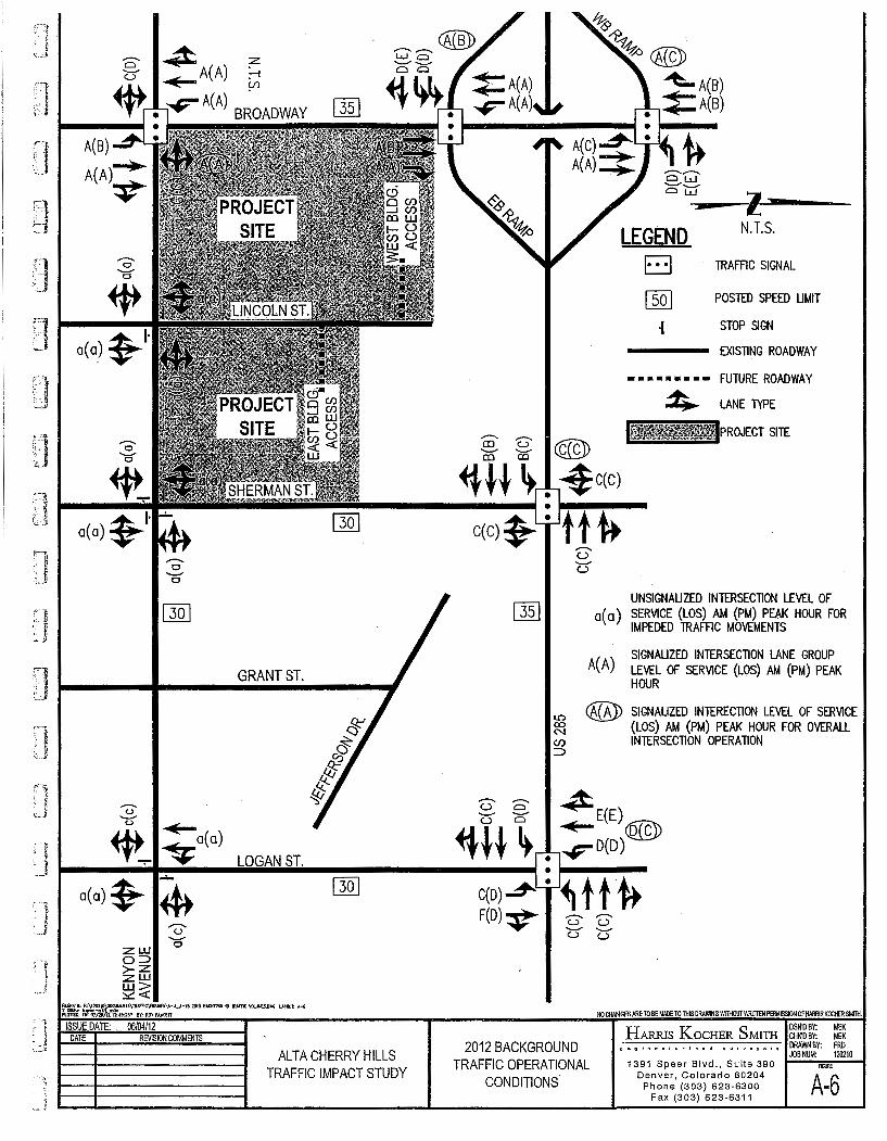
'". 1 r. I u
n '.''-·~ ;_: j
q J
A(B)
A( A);.
::1 ::~ ----L .. ~
u fJ GRANTST. cJ .... ---t---..--......--.---rl
zw o=> >-Z zw ~~
ALTA CHERRY HILLS TRAFFIC IMPACT STUDY
C(D) F(D)~
LEGEND E1
zn N.T.S.
lRAffiC SIGNAL
I 50 I POSlED SPEED LIMIT
·I STOP SIGN
EXISTING ROADWAY
• • • • • • • • • FUTURE ROADWAY
~ LANE TYPE
llllff-PROJECT SITE
UNSIGNAUZED INTERSECTION LEVEL OF a( a) SERVICE (LOS) AM (PM) PEAK HOUR FOR
IMPEDED lRAFRC MOVEMENTS
A(A) SIGNALIZED INTERSECTION LANE GROUP LEVEL OF SERVICE (LOS) AM (PM) PEAK HOUR
tn (j{N) SIGNALIZED INTERECTION LEVEL OF SERVICE ~ (LOS) AM (PM) PEAK HOUR FOR OVERALL Cl) INlERSECTION OPERATION :::>
MEK MEK
2012 BACKGROUND TRAFFIC OPERATIONAL
CONDITIONS
FRO 120210
1391 Speer Blvd., Suite 390 1---~~--1 Denver, Colorado 80204
Phone (303} 623-6300 Fax (303) 623-6311
A-6
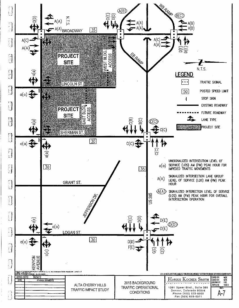
.. rJ.·, ' . ,. .,.
r ... 1. : .. _)
r-:-J .. ,_
q ;.._,]
A( C)
A(A)-;..
~] t----t----G-RA;.;;.;.NT.;_;;.ST;.;_· ---J
:ZUJ 0::::> >-:Z :zw w> ~<(
2lll5 B~CKGROJHD 1iWFIC VQJJI.I(S.OWC LAYOUT: A-7
ALTA CHERRY HILLS TRAFFIC IMPACT STUDY
D(D) F(E)T
<®> ~A(B) ~A(B)
JZ32 l N.T.S.
LEGEND G TRAFFIC SIGNAL
~ POSTED SPEED UMIT
·I STOP SIGN
---- EXISTING ROADWAY
• • • • • • • • • FUTURE ROADWAY
~ LANE TYPE
llli;,~flti)PROJECT SITE
UNSIGNAUZED INTERSECTION LEVEL OF a(a) SERVICE (LOS) AM (PM) PEAK HOUR FOR
IMPEDED TRAFFIC MOVEMENTS
A(A) SIGNALIZED INTERSECTION LANE GROUP LEVEL OF SERVICE (LOS) AM (PM) PEAK HOUR
LO @ SIGNALIZED INTERECTION LEVEL OF SERVICE ~ (LOS) AM (PM) PEAK HOUR FOR OVERALL oo INTERSECTION OPERATION ::::>
I
HARRIS KocHER SMITH DSN'D BY: MEK CHK:DBY: MEK
2015 BACKGROUND TRAFFIC OPERATIONAL
CONDITIONS 1391 Speer Blvd., Suite 390
Denver, Colorado 80204 Phone (303) 623-6300
Fax (303) 623-6311
DRAWN BY: FRO JOB NUM: 120210
A-7

A(D)
A( A);
rjr-, .
\._ '
r·]·.· ' . \ .... -.
q GRANTST. ;JI----1~-....-.---...._-.J
q J
zw o=> >-Z zw ~~
...-... u ...__.. u
ALTA CHERRY HILLS TRAFFIC IMPACT STUDY
D(D) F(E)~
... l
LEGEND G lRAFFIC SIGNAL
(]Q] POSTED SPEED UMIT
·I STOP SIGN
EXISTING ROADWAY
• • • • • • • • • FUTURE ROADWAY
~ LANE TYPE
~~~~~~~PROJECT SITE
UNSIGNAUZED INTERSECTION LEVEL OF a( a) SERVICE (LOS) AM (PM) PEAK HOUR FOR
IMPEDED lRAFFIC MOVEMENTS
A(A) SIGNAUZED INTERSECTION LANE GROUP LEVEL OF SERVICE (LOS) AM (PM) PEAK HOUR
@ SIGNAUZED INTERECTION LEVEL OF SERVICE (LOS) AM (PM) PEAK HOUR FOR OVERALL INTERSECTION OPERATION
1391 Speer Blvd., Suite 390 F~~~ Denver, Colorado 80204
Phone (303) 623-6300 Fax (303) 623-6311
A-8

:as l N.T.S.
] ............... _ ',.._:,J
CJ.----t----G_RA_N_r_s_r_. ___ _,
'~] ZLU O::> >-Z zw ~~
ALTA CHERRY HILLS TRAFFIC IMPACT STUDY
LEGEND ----- EXISllNG ROADWAY
•••••••••• ~XX%._
FUTURE ROADWAY
DIRECllONAL DISTRIBUllON OF SITE GENERATED TRIPS
SITE GENERA TED TRIP DISTRIBUTION
PROJECT SITE
HARRis KocHER SMITH
1391 Speer Blvd., Suite 390 Denver, Colorado 80204
Phone (303) 623-6300 Fax (303) 623-6311
BY: MEK CHK'DBY: MEK DRAWN BY: FRO JOB NUM: 120210
A-9
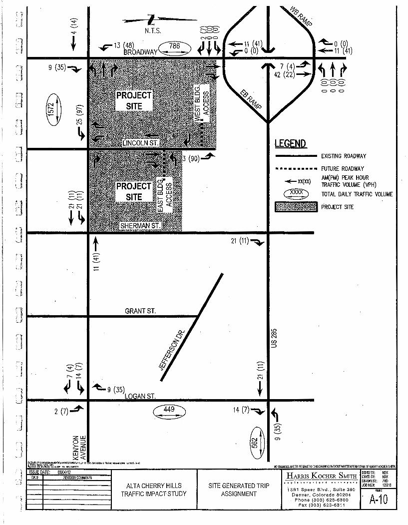
:---, ,, "
]
f1 ·;-l d
~-------9 (35).
'l t------0]
" ~ ,_j------
c--, - ~ ~~
AU
N.T.S.
t
r-~ .... ____ .._ __ _..G .. RA.._N-.r-.sr-.. ----1 :._)
,-_-, - 1 j
i
·-·- j
,-l ·~.J
zw O::l >-Z zw w> ~<(
ALTA CHERRY HILLS TRAFFIC IMPACT-STUDY
21 (11)y
~
'--""
N
~ 14 (7)y
ij SITE GENERATED TRIP
ASSIGNMENT
~0 (0) -.-11 (41)
ooo
-LEGEND ---- EXISTING ROADWAY
• • • • • • • • • • FUTURE ROADWAY
~ XX(XX) AM(PM) PEAK HOUR lRAmC VOLUME {VPH)
~ TOTAL DAILY lRAFRC VOLUME
~~~~~~~~~~ PROJECT SITE
lO co N (f) ::l
~ .......... LO n ...__, 0">
HARRis KocHER SMITH
1391 Speer Blvd,, Suite 390 Denver, Colorado 80204
Phone (303) 623-6300 Fax (303) 623-6311
OSN!lBY: MEK CHK'OBY: MEK DRAWN BY: FRO JOB NUM: 120210
- A-10

r_._-·]. ". ,._._ L ..
t.-.--]. r-i. l __ .i
118 (66l-4' 1707 (1184 .....
15 (58 .....
,..-...";:::' r-o c.o ~ ....__-....-~c.o
~$~ 9 (1l-4' 1 (4 ~ 1 {3 .....
JLLS2 l N.T.S.
'j GRANTST. b t----+----------1
rj. ~-
.-l •. t ,_J
ALTA CHERRY HILLS TRAFFIC IMPACT STUDY
I ----623 (1500) .. 57(9~ ~52 (212)
~532 (1319)
~ (215)...4'-1398 (976)
5 (7l-4' 15 {13 ~ 35 (24 .....
2015 TOTAL TRAFFIC VOLUMES
---- EXISTING ROADWAY
• • • • • • • • • ior FUTURE ROADWAY
~XX(XX) AM(PM) PEAK HOUR lRAFFIC VOLUME (VPH)
TOTAL DAILY lRAFFIC VOLUME
llf.BIII PROJECT SITE
~12 (21) ..-4 (19) .y7 (14)
HARRis KocHER SMITH a ng I n.•" '" • 1 • n d s u rv• y a r 1
DSN'DBY: CHK'DBY: DRAWN BY: JOBNUM:
1391 Speer Blvd., Suite 390 1--~~-t Denver, Colorado 80204
Phone (303) 623-6300 Fax (303) 623-6311
A-11

·~1 , _J
Ct. (_,j
q GRANTST. ul-----1~-.....~-..... ...... .._ __ -#
--,-, i E l ;
'-.... 1
ZUJ 0~ >-::Z: zw LLJ> ::::c:<t:
ALTA CHERRY HILLS TRAFFIC IMPACT STUDY
B I 670 (1613)
.. 62 (10~ ~56 (228) ~573 (1419)
~ (231).4'--1503 (1051)
5 (7l-4' 16 (14 ..... 36 (25 ..
2030 TOTAL TRAFFIC VOLUMES
---- EXISTING ROADWAY
• • • • • • • • • • FU1URE ROADWAY
~XX{XX) AM(PM) PEAK HOUR TRAFFIC VOLUME (VPH)
~ TOTAL DAILY TRAFFIC VOLUME
IIIIIIIIIBI PROJECT SITE
~13 (22) .... 4 (20) ...-7 (15)
1391 Speer Blvd., Suite 390 Denver, Colorado 80204 A 12
-· ~---.- I---.J---------1 Phone (303) 623-6300 • . Fax {303) 623-6311 _j t=c:======l___ ____ .L_ ____ ..L..-~~-----1..-----1

'1 .·_I ' J
rJ-,_.
A( C)
B(A)-:;..
!A(A)
.----.. 0 ...._.. 0
A(A) BROADWAY
"l GRANT ST. . ~~------1---------~~------~ t.J
r]
:zw O::::> >-:Z iii·~ ::,:::<(
.----.. u ...._.. u
::sa l N.T.S.
LEGEND G TRAFFIC SIGNAL
I 50 I POSTED SPEED UMIT
·I STOP SIGN
EXISTING ROADWAY
• • • • • • • • • FUlURE ROADWAY
~ LANE TYPE
il~i$.:£4!~~!!r;&,ztJt.;t PR J ~.,\1Jlm.k~$S~&'!it~ 0 ECT SITE
UNSIGNAUZED INTERSECTION LEVEL OF a( a) SERVICE (LOS) AM (PM) PEAK HOUR FOR
IMPEDED TRAFFIC MOVEMENTS
A(A) SIGNAUZED INTERSECTION LANE GROUP LEVEL OF SERVICE (LOS) AM (PM) PEAK HOUR
t.n (j§j}j SIGNAUZED INTERECTION LEVEL OF SERVICE ~ (LOS) AM (PM) PEAK HOUR FOR OVERALL GO INTERSECTION OPERATION ::::>
2: e !o(E)
~l~ \ • E(E)<@)J
D(D) F(E)~
1391 Speer Blvd., Suite 390
DSN'DBY: MEK CHK:D BY: MEK DRAWN BY: FRD JOB NUM: 120210 ALTA CHERRY HILLS
TRAFFIC IMPACT STUDi
2015 TOTAL TRAFFIC OPERATIONAL
CONDITIONS ·--~ r-----1--------l Denver, Colorado 80204 A 1 . i Phone (303} 623·6300 • 3 ·--' ....__... _______ ..__ _______ _JL_ _______ __JL_:F~ax~(~30~3}~6::;23~-6~3~11 _ _j__:_~.:_j

:] q ;_j
] r .. :·j ,.
L_
~j
Ei I' N ~- ,jt-
q .. J
~---~ A(E)
B(A)~
-!A(B)
.---.. c ..__.. c
A(A) BROADWAY
D ~----~~----~G~AA~NT~S~T··------~
:1 , I ._J
zw o::> >-Z zw w> :::.::::<(
,., 1 1--t-------.1 if--t--------1
D(D) F(E)V"
.---.. w ..__.. u
== l N.T.S.
LEGEND B TRAme SIGNAL
[]QJ POSTED SPEED LIMIT
·I STOP SIGN
EXISTING ROADWAY
• • • • • • • • • FUTURE ROADWAY
~ LANE TYPE
SITE
UNSIGNALIZED INTERSECTION LEVEL OF a( a) SERVICE (LOS) AM (PM) PEAK HOUR FOR
IMPEDED TRAFFIC MOVEMENTS
A(A) SIGNALIZED INTERSECTION LANE GROUP LEVEL OF SERVICE (LOS) AM (PM) PEAK HOUR
~ SIGNALIZED INTERECTION LEVEL OF SERVICE ~ (LOS) AM (PM) PEAK HOUR FOR OVERALL ~ INTERSECTION OPERATION :::::>
A-14
ORDINANCE NO. SERIES OF 2012
BY AUTHORITY
COUNCIL BILL NO. 58 INTRODUCED BY COUNCIL MEMBER __________ _
A BILL FOR
AN ORDINANCE APPROVING THE FLOOD MS PLANNED UNIT DEVELOPMENT (PUD), BY BARBURY HOLDINGS, LLC LOCATED AT THE NORTHEAST CORNER OF SOUTH BROADWAY AND KENYON A VENUE ALSO KNOWN AS 3695 SOUTH LINCOLN STREET, IN THE CITY OF ENGLEWOOD, COLORADO.
WHEREAS, Englewood School District #1 are the owners of the property at the Northeast comer of South Broadway and Kenyon Avenue, also known as 3695 South Lincoln Street, Englewood, Colorado; and
WHEREAS, the former Flood Middle School site consists of two parcels totaling 4.56 acres; and
WHEREAS, this property is the former Flood Middle School site and has been vacant since 2007;and
WHEREAS, the Englewood School District issued a request for proposals to redevelop the Flood Middle School property however, no viable development proposals has come forward except for Barbury PUD application; and
WHEREAS, in 2011 Barbury Holdings, LLC submitted a proposal to purchase the property and proposed development ofthe property to include a 350 maximum residential apartment units contained within two buildings, a multi-level parking structure which would be accessed off of South Lincoln Street, several courtyards, perimeter landscaping, and minimum 5 foot wide sidewalks, and all new and existing utilities within the property and abutting Right-of-Way would be placed underground; and
WHEREAS, the former Flood Middle School site existing Zone Districts are MU-R-3-B, MUB-1, and R-2-B, all of which include multi-unit dwellings as permitted uses; and
WHEREAS, Barbury Holdings, LLC submitted an application to rezone the property to a Planned Unit Development (PUD) because the existing zoning designation would not accommodate the proposed development; and
WHEREAS, a traffic impact study for the proposed Flood MS PUD showed an increase in overall traffic volume; however, the study concluded that the development can be accommodated by the existing area roadways and intersections without modification and without creating significant impacts to the area through 2030; and
WHEREAS, the Englewood Public Works Traffic Division and the Colorado Department of Transportation both concurred with the traffic impact study fmdings; and
WHEREAS, the proposed Flood MS Planned Unit Development will exceed the development quality standards required by the Englewood Unified Development Code for residential development; and
WHEREAS, the property cannot be developed, or no reasonable economic use of the property can be achieved, under the existing zoning, even through the use of conditional uses or a reasonable number of Zoning Variances or Administrative Adjustments; and
WHEREAS, the Planning and Zoning Commission held Public Hearing on September 18, 2012; and
WHEREAS, the Planning and Zoning Commission made the following findings:
1. The proposed rezoning is consistent with the Comprehensive Plan and the Unified Development Code.
2. The application is consistent with adopted and generally accepted standards of development in the City.
3. The application is consistent with the goals, objectives, design guidelines, policies and other ordinances, laws, or requirements of the City.
4. The resulting rezoned property will not have a significant negative impact on those properties surrounding the rezoned area and that the general public health, safety and welfare of the community are protected; and
WHEREAS, the Planning and Zoning Commission recommends approval of the Flood MS Planned Unit Development with the following conditions:
1. The maximum number of allowed units shall be 310. 2. A minimum 20% of the property shall be landscaped. 3. The Park Dedication Fee-in-lie shall not be reduced from the City Council adopted
fee of $20,000 per required acre as required by the Unified Development Code.
NOW, THEREFORE, BE IT ORDAINED BY THE CITY COUNCIL OF THE CITY OF ENGLEWOOD, COLORADO, AS FOLLOWS:
Section 1. The Flood MS Planned Unit Development (PUD), for property located at the northeast comer of South Broadway and Kenyon A venue, in the City of Englewood, Colorado, attached hereto as Exhibit A, is hereby approved with the conditions noted above.
Introduced, read in full, and passed on first reading on the 5th day of November, 2012.
Published by Title as a Bill for an Ordinance in the City's official newspaper on the 9th day of November, 2012.
Published as a Bill for an Ordinance on the City's official website beginning on the 7th day of November, 2012 for thirty (30) days.
RandyP. Penn, Mayor ATTEST:
Loucrishia A. Ellis, City Clerk
I, Loucrishia A. Ellis, City Clerk of the City of Englewood, Colorado, hereby certify that the above and foregoing is a true copy of a Bill for an Ordinance, introduced, read in full, and passed on first reading on the 5th day of November, 2012.
Loucrishia A. Ellis

VICINITY MAP
NORTH
ENGLEWOOD - HIGH
SCHOOL
LEGAL DESCRIPTION
LOTS 13 THROUGH 19, INCLUSIVE AND 26 THROUGH 38, INCLUSIVE, BLOCK 1, HIGGINS BROADWAY ADDITION, . COUNTY 0~ ARAPAHOE, STATE OF COLORADO; AND LOTS 20 THROUGH 25, BlOCK 1, HIGGINS BROADWAY ADDITION, COUNTY OF ARAPAHOE, STATE OF COLORADO; AND LOTS 10,11 AND 12, BLOCK 1, HIGGINS BROADWAY ADDITION, COUNTY OF ARAPAHOE, STATE OF COLORADO; AND LOTS 6 THROUGH 9, INCLUSIVE AND 39 THROUGH 50, INCLUSIVE, BLOCK 1, HIGGINS BROADWAY ADDITION, COUNTY OF ARAPAHOE, STATE OF COLORADO,
EXCEPT THAT PORTION CONVEYED TO THE CITY OF ENGLEWOOD IN DEED RECORDED JANUARY 24, 195BIN BOOK 952 AT PAGE 79 AND THAT PORTION CONVEYED TO THE STATE DEPARTMENT HIGHWAYS, DIVISION OF HIGHWAYS, STATE OF COLORADO IN DEED RECORDED JULY 21,1970 IN BOOK 1875 AT PAGE 110.
TOGETHER WITH
LOT 30 AND THE SOUTH ONE HALF OF LOT31, BLOCK 2, HIGGINS BROADWAY ADDITION, COUNTY OF ARAPAHOE, STATE OF COLORADO; AND LOTS 17 AND 18, BLOCK 2, HIGGINS BROADWAY ADDITION, COUNTY OF ARAPAHOE, STATE OF COLORADO; AND LOT 19 AND THE NORTH ONE HALF OF LOT 20, BLOCK 2, HIGGINS BROADWAY ADDITION, COUNTY OF ARAPAHOE, STATE OF COLORADO; AND THE NORTH ONE HALF OF LOT 31 AND ALL OF LOT 32, BLOCK 2, HIGGINS BROADWAY ADDITION, COUNTY OF ARAPAHOE, STATE OF COLORADO; AND LOTS 24 AND 25, BLOCK 2, HIGGINS BROADWAY ADDITION, COUNTY OF ARAPAHOE, STATE OF COLORADO; AND THE SOUTH ONE HALF OF LOT 20 AND ALL OF LOT 21, BLOCK 2, HIGGINS BROADWAY ADDITION, COUNTY OF ARAPAHOE, STATE OF COLORADO; AND LOTS 28 AND 29, BLOCK 2, HIGGINS BROADWAY ADDITION, COUNTY OF ARAPAHOE, STATE OF COLORADO; AND LOTS 33, 34 AND 35, BLOCK 2, HIGGINS BROADWAY ADDITION, COUNTY OF ARAPAHOE, STATE OF COLORADO; AND LOTS 26 AND 27, BLOCK 2, HIGGINS BROADWAY ADDITION, COUNTY OF ARAPAHOE, STATE OF COLORADO; AND LOTS 22 AND 23, BLOCK 2, HIGGINS BROADWAY ADDITION, COUNTY OF ARAPAHOE, STATE OF COLORADO; AND LOTS 15 AND 16, BLOCK 2, HIGGINS BROADWAY ADDITION, COUNTY OF ARAPAHOE, STATE OF COLORADO, EXCEPTTHAT PORTION CONVEYED TO THE CITY OF ENGLEWOOD BY DEED RECORDED OCTOBER 21, 19641N BOOK 1554 AT PAGE 390.
CONTAINING A TOTAL AREA OF 198,804 SQUARE FEET OR 4.58 ACRES.
FLOOD MS PLANNED UNIT DEVELOPMENT ENGLEWOOD, COLORADO
PROJECT BACKGROUND
THIS PROJECT AT 3650 S. BROADWAY IS COMPRISED OF 2 PARCELS (PARCEL I.D#2077-03-1-08-004 & #2077-03-1-09-006) TOTALING APPROXIMATELY 4.6 ACRES. THE FIRST (WEST) PARCEL (KNOWN HEREIN AS PARCEL 01) IS LOCATED AT THE NORTHEAST CORNER OF S. BROADWAY AND E. KENYON. THE SECOND (EAST) PARCEL (KNOWN HEREIN AS PARCEL 02) IS LOCATED DIRECTLY EAST OF THE WEST PARCELATTHE NORTHEAST CORNER OF S. LINCOLN AND E. KENYON. PRESENTLYTHE WEST PARCEL CONTAINS, THE NOW CLOSED, FLOOD MIDDLE SCHOOL WHICH WILL BE DEMOLISHED AS A PART OF THIS PROPOSED DEVELOPMENT. THE EAST PARCEL IS VACANT. THE CURRENT ZONING OF THE WEST PARCELlS MU-R-3-B WITH THE NORTHERNMOST MOST PORTION BEING ZONED MU-B-1. THE WEST HALF OF THE EAST PARCEL IS MU-R-3-B AND THE EAST HALF OFTHE EAST PARCEL ZONED R-2-B. THIS PUDWILL BRING ALL PARCELS UNDER THE SAME ZONING DESIGNATION AS OUTLINED WITHIN THIS PUD DOCUMENT. THE PLANNED UNIT DEVELOPMENT WILL BE PROCESSED PURSUANT TO THE APPLICABLE CITY REGULATIONS.
CONSTRUCTION/PHASING PLAN
INITIAL DEMOLITION OF THE EXISTING BUILDINGS ON-SITE SHALL TAKE APPROXIMATELY 3 MONTHS~ .. ONCE DEMOLITION IS COMPLETE NEW CONSTRUCTION SHALL TAKE APPROXIMATELY 22 MONTHS. iT . IS ANTICIPATEDTHiiTTHE FIRST RESIDENTIAL UNITS WILL BE READY FOR OCCUPANCY APPROXIMATELY 12 MONTHS AFTER NEW CONSTRUCTION BEGINS.
PUD DEVELOPMENT SUMMARY
THE APPLICANT PROPOSES TO DEVELOP A MAXIMUM OF 350 RESIDENTIAL 'FOR-RENT' APARTMENT UNITS CONTAINED WITHIN TWO BUILDINGS DEVELOPED ON PARCEL 01 AND PARCEL 02. PARKING SHALL MOSTLY BE PROVIDED IN A PARKING STRUCTURE THAT WILL PREDOMINANTLY BE WRAPPED/SCREENED BY THE APARTMENT BUILDING. VEHICULAR AND BICYCLE PARKING SHALL BE .. PROVIDED BASED ON MINIMUM CITY CODE REQUIREMENTS. SEVERAL COURTYARD/AMENITY AREAS· ARE INCORPORATED INTO THE DESIGN THAT WILL ALSO INCLUDE LANDSCAPING. ·:-:-'
~~~~~~g~~O~~~JEe;:N~~~:;~;~~~~~~~:~~6~~~~~~~~~~L~:~6~~~~~~~ALIZATIO~:: REDEVELOPMENT AND REINVENTION. THE ABANDONED FLOOD MIDDLE SCHOOL CURRENTLY ,. 'i. OCCUPIES THIS SITE. THE PROPOSED PROJECT WILL REDEVELOP THIS SITE INTO A VIBRANT, HIGH. ".:., QUALITYRESIDENTIALCOMMUNITYTHAT FITS INTO THE EXISTING MIX OF USES THAT SURROUND HiE ·. SITE THAT INCLUDE A MIX OF SINGLE FAMILY, DUPLEX AND MULTI-FAMILY RESIDENCES, AS WELL AS COMMERCIAURETAIL USES. THIS PROJECT WILL REVITALIZE THIS ESTABLISHED NEIGHBORHOOD ., AREA AND PROVIDE A UNIQUE HOUSING OPTION FOR RESIDENTS IN THIS LOCATION. THIS PROJECT ':, .. TAKES ADVANTAGE OF EXISTING COMMUNITY INFRASTRUCTURE AND TRANSPORTATION OPTIONS 0\ · WHILE REINVESTING IN AN EXISTING ESTABLISHED NEIGHBORHOOD. THE ADDITIONAL RESIDENTS '\! WILL TAKE ADVANTAGE OF THE EXISTING RETAIL IN THE NEIGHBORHOOD AND GENERATE TAX l' REVENUE THAT WILL BENEFIT PROGRAMS AND SERVICES PROVIDED BYTHE CITY OF ENGLEWOOD. · r
PUD PLAN NOTES
1. THIS PROPERTY DOES NOT LIE WITHIN A 100-YEAR FLOODPLAIN. 2. ALL NEW AND EXISTING UTILITIES WITHIN THE PROPERTY AND ABUTIING RIGHT-OF-WAY SHALL
BE PLACED UNDERGROUND. 3. ALL CONCRETE WORK DONE IN THE PUBLIC RIGHT-OF-WAY SHALL BE IN CONFORMANCE WITH
CONSTRUCTION STANDARDS AND CONCRETE SPECIFICATIONS FOR THE CITY OF ENGLEWOOD, COLORADO.
4. ANY NEW FIRE HYDRANTS SHALL BE TO THE CITY OF ENGLEWOOD REQUIREMENTS. 5. SUBDIVISION OF THE SITE SHALL BE COMPLETED UNDER SEPARATE DOCUMENT. 8. ALL STRUCTURES AND PROJECTIONS (UNLESS OTHERWISE NOTED WITHIN THIS PUD) SHALL BE
CONSTRUCTED WITHIN BUILDING ENVELOPES AND BUILDING HEIGHT LIMITS. 7. THE DEVELOPER SHALL COMPLY WITH ALL APPLICABLE CITY CODES, REGULATIONS, AND
STANDARDS NOT SPECIFICALLY ADDRESSED WITHIN THIS PUD. 8. IN THE EVENT OF A CONFLICT BETWEEN THE SPECIFIC PROVISIONS OF THIS PUD AND TITLE 16,
THE SPECIFIC PROVISIONS OF THIS PUD SHALL CONTROL 9. THE EXISTING CITY DITCH MAY BE REALIGNED AS PART OF FUTURE DEVELOPMENT.
CONTACT LIST
OWNER: ENGLEWOOD SCHOOL DISTRICT #1 ATIN: BRIAN EWERT 4101 SOUTH BANNOCK STREET ENGLEWOOD, COLORADO 80110 303.761.7050 BRIAN [email protected]
PLANNER/APPLICANT REPRESENTATIVE: NORRIS DESIGN ATIN: WENDI BIRCHLER 1101 BANNOCK STREET DENVER, COLORADO 80204 303.892.1166 [email protected]
CIVIL ENGINEER: HARRIS KOCHER SMITH ATIN: BILLY HARRIS 1391 SPEER BOULEVARD, SUITE 390 DENVER, COLORADO 80204 303-623-6300 [email protected]
SHEET INDEX COVER SHEET DISTRICT PLAN EXISTING SITE PLAN PROPOSED SITE PLAN PROPOSED UTILITY PLAN PROPOSED DRAINAGE PLAN PROPOSED LANDSCAPE PLAN CONCEPTUAL ARCHITECTURE
01 02 03 04 05 06 07 08
APPLICANT: BARBURY HOLDINGS, LLC ATIN: EDWARD BARSOCCHI 4725 SOUTH MONACO ROAD, SUITE. 205 DENVER, COLORADO 80237 303.827.9670 [email protected]
ARCHITECT: PBA ATIN: ROBERT MULLER 1633 YORK STREET DENVER, COLORADO 80206 303.592.2904 [email protected]
TRAFFIC ENGINEER: HARRIS KOCHER SMITH ATIN: MIKE KIBBEE 1391 SPEER BOULEVARD, SUITE 390 DENVER, COLORADO 80204 303-623-6300 [email protected]
EXHIBIT A
SIGNATURE BLOCKS
APPROVED FOR ENGLEWOOD SCHOOL DISTRICT
SIGNATURE DATE
STATE OF COLORADO
COUNTY OF=====-=-: THE FOREGOING INSTRUMENT WAS ACKNOWLEDGED BEFORE ME THIS--DAY OF A.D.,20_BY AS _____________ OF _________ _
MY COMMISSION EXPIRES----------·
NOTARY PUBLIC
ADDRESS
APPROVED FOR THE CITY OF ENGLEWOOD
PLANNING AND ZONING COMMISSION CHAIRPERSON DATE
PLANNING AND ZONING COMMISSION RECORDING SECRETARY
MAYOR OF ENGLEWOOD DATE
ATIESTED THE FOREGOING INSTRUMENT WAS ACKNOWLEDGED BEFORE ME THIS---· DAYOF A.D.,20_BY . AS
. OF __________ .
CITY CLERK
CLERK AND RECORDER'S OFFICE
THIS PLANNED UNIT DEVELOPMENT IS ACCEPTED FOR FILING IN THE OFFICE OF THE CLERK AND RECORDER OF ARAPAHOE COUNTY, COLORADO AT----,----O'CLOCK, _. M. THIS ___ DAY OF .
----:---:===---· 20 __ . RECEPTION NUMBER ______ BOOK NUMBER _____ PAGE NUMBER ___ _
CLERK AND RECORDER BY: DEPUTY
SHEET TITLE:
COVER SHEET
SHEET#:
01 of 08
N
~ CD 0
.:..;
~ :1 "' :::J en
~ ~ N
"' 0 ;::; ~ ~ Q r- co m 0 0 0
c; gj "' .. .. ~ w w w w w ~ ~ ~ ~ ~ 0 ~ ~ .. .. .. z z z z z 0 0 0 0 0 1i5 1i5 1i5 1i5 U5 5 w 0::
<{ co 0.
15 0::
15 0::
1-z w
15 0::
2o a..o 0<( .....Ja:: w>o
.....1
15 0::
wo CJ) 0 0 IIIII::: I- c) .:::::; so Co~ O~w Oz.....! ..J <(C) •• .....JZ ...... [L w

ARCHITECTURAL CHARACTER
THE ARCHITECTURAL CHARACTER OF THIS DEVELOPMENT SHALL BE URBAN IN CHARACTER AND WILL PROVIDE FOR A PEDESTRIAN SCALE ALONG THE STREET LEVEL. DESIGN SHALL INCLUDE THE FOLLOWING:
a. A MINIMUM OF ONE 5' BUILDING PLANE CHANGE EVERY 45 LINEAR FEET. THIS MAY BE ACCOMPLISHED IN A NUMBER OF WAYS INCLUDING RECESSED BALCONIES OR PORCHES, BUT SHALL NOT INCLUDE CANTILEVERED BALCONIES OR PORCHES. PARKING GARAGES ARE EXCLUDED FROM THIS BUILDING PLANE CHANGE REQUIREMENT.
b. A MINIMUM OF 3 DIFFERENT MATERIAL PATIERNS AND COLOR CHANGES SHALL BE INCORPORATED INTO THE BUILDING DESIGN. IT IS ENCOURAGED THAT THESE MATERIALS ARE DISTRIBUTED AS EVENLY AS POSSIBLETHROUGHOUTTHE BUILDING DESIGN. ATLEAST ONE ADDITIONAL COLOR AND/OR MATERIAL WILL BE USED TO DIFFERENTIATE IMPORTANT ARCHITECTURAL ELEMENTS SUCH AS CORNERS, ENTRIES, AND COMMON USE AREAS.
c. AN AVERAGE OF 30% OF THE BUILDING FACADE SHALL CONSIST OF MASONRY, WHICH MAY INC.LUDE BRICK, STONE, AND/OR CMU. NO ELEVATION FACING A PUBLIC STREET SHALL HAVE LESS THAN 20% MASONRY.
d. STUCCO, STONE, CMU, BRICK, CEMENTITIOUS (INCLUDING JAMES HARDIE & SIMILAR), AND METAL SIDING ARE PERMISSIBLE BUILDING MATERIALS.
e. ATTHE CORNER OF S. BROADWAY AND KENYON THE BUILDING FACADE SHALL BE 80% TRANSPARENT FORA HEIGHT OF AT LEAST 20', ACTIVATING THE STREET WITH THE ACTIVITY OF THE AMENITY AREAS WITHIN THE CLUBHOUSE.
f. PREDOMINANT BUILDING ENTRIES SHALL BE CLEARLY DEFINED AND MAY CONSIST OF ELEMENTS SUCH AS; CANOPIES, OVERHANGS, PEAKED ROOFS, ARCHES, AND/OR OUTDOOR
· AMENITIES (I.E. BENCHES, BOLLARDS, PEDESTRIAN LIGHTS, AND SIMILAR). g. ROOFS MAY BE SLOPED AND/OR FLAT WITH SLOPED ROOFS RANGING FROM A MINIMUM 4:12
TO A MAXIMUM OF 6:12.
FUTURE DEVELOPMENT SHALL INCORFORATE THE AFOREMENTIONED FEATURES TO CREATE AESTHETICALLY PLEASING BUILDINGS THAT HAVE STRONG ARCHITECTURAL CHARACTER WITH HIGH QUALITY FINISHES.
PUD DISTRICT PLAN DEVELOPMENT STANDARDS A. GENERAL REGULATIONS: UNLESS OTHERWISE PROVIDED FOR IN THIS PUD OR SUBSEQUENT
AMENDMENTS, THE PROVISIONS, STANDARDS, REGULATIONS AND PROCEDURES PERTINENT TO AN APPLICATION FOR THE DEVELOPMENT OF LAND WITHIN THIS PUD ZONE DISTRICT SHALL COMPLY WITH THE MU·R-3·B ZONE DISTRICT OF THE CITY OF ENGLEWOOD AND RELATED. ZONING REGULATIONS IN EFFECT ATTHE TIME ANY FUTURE APPLICATION IS FILED WITH THE CITY.
B. PERM/TIED LAND USES: 1. MULTI UNIT DWELLING (INCLUDING ANCILLARY USES SUCH AS LEASING OFFICE, PRIVATE
RECREATION FACILITIES, ETC.) 2. SURFACE PARKING 3. PARKING GARAGE
ACCESSORY USE: 1. HOME OCCUPATION AS DEFINED IN THE UNIFIED DEVELOPMENT CODE (UDC)
PERM/TIED ACCESSORY STRUCTURES: 1. POOL EQUIPMENT/MAINTENANCE BUILDING ·1 PERM/TIED AT 250 SF EACH 2. TRELLIS - MAXIMUM 3 PERM/TIED AT 250 SF EACH 3. GAZEBO· MAXIMUM 3 PERM/TIED AT 250 SF EACH
C. UNLISTED USES PROCEDURES FOR APPROVAL OF USES NOT LISTED IN THE ABOVE PERMITIED USES SHALL BE GOVERNED BY TITLE 16 PROVISIONS FOR UNLISTED USES.
D. DEVELOPMENT STANDARDS THE FOLLOWING STANDARDS APPLYTO PARCEL 01 AND PARCEL 02 UNLESS OTHERWISE NOTED.
1. MAXIMUM BUILDING HEIGHT: a. PARCEL 01 -APPROXIMATELY 60' TO 78' ABOVE GRADE OF ADJACENT RIGHT-OF-WAY
(MAXIMUM U.S.G.S ELEVATION OF 5,416') b. PARCEL 02 -APPROXIMATELY 60' TO 70' ABOVE GRADE OF ADJACENT RIGHT-OF-WAY
(MAXIMUM U.S.G.S ELEVATION OF 5,414') c. ANTENNAS, MECHANICAL EQUIPMENT, ELEVATOR PENTHOUSES, CHIMNEYS, AND
SIMILAR ARE EXCLUDED FROM THIS LIMITATION.
2. MAXIMUM PERM/TIED RESIDENTIAL UNITS: a. 76.75 DUlAC OR 350 UNITS (TOTAL COMBINED FOR PARCELS 01 & 02) b. PROJECTED UNIT SCHEDULE:
-1-BEDROOM- -65% - 2-BEDROOM- -30% - 3-BEDROOM- -5%
• NOTE: UNIT SCHEDULE SUBJECT TO CHANGE BASED ON CURRENT MARKET CONDITIONS AT TIME OF CONSTRUCTION. FINAL BREAKDOWN WILL BE PROVIDED AT TIME OF BUILDING PERMIT.
FLOOD MS PLANNED UNIT DEVELOPMENT ENGLEWOOD, COLORADO
.....
PUD DISTRICT PLAN DEVELOPMENT STANDARDS (CONT.)
3. SETBACKS
BUILDING INCLUDES PARKING STRUCTURES PARCEL01 PARCEL02 FROM S. BROADWAY ROW 0' N/A FROM E. KENYON ROW 10' 10' FROM S. LINCOLN ROW 5' 5' FROM S. SHERMAN ROW N/A 10' FROM NORTH BOUNDARY PARCEL 01 10' N/A FROM NORTH BOUNDARY ADJACENT TO ALLEY N/A 5' FROM NORTH BOUNDARY ADJACENT TO EXISTING RESIDENTIAL N/A 10' FROM INTERNAL LOT LINE 0' o·
SURFACE PARKING PARCEL 01 PARCEL 02l l FROM BUILDINGS o· o•
FROM PUBLIC ROW 5' 5'
4. BULK STANDARDS: a. MAXIMUM LOT COVERAGE: PARCEL 01 - 75'¥, PARCEL 02-80% b. BUILD TO LINE- AT LEAST 33% OF THE BUILDING FRONTAGE ALONG S.
BROADWAY SHALL BE BUILT NO FURTHER BACK THAN 5' FROM THE PROPERTY LINE.
c. BUILD TO LINE- NO MORE THAN 33% OF BUILDING WILL BE SETBACK GREATER THAN 25' FROM S. BROADWAY.
d. STANDARD BULK PLANE REQUIREMENTS AS DEFINED BY THE CITY OF ENGLEWOOD SHALL ONLY APPLY TO THE EASTERN HALF OF THE NORTHERN BOUNDARY OF PARCEL 02, WHERE THE BUILDING IS DIRECTLY ADJACENTTO EXISTING RESIDENTIAL AND NOTTHE PORTION OF THE NORTHERN BOUNDARY THATIS DIRECTLY ADJACENTTO THE ALLEYWAY.
5. PARKING STANDARDS: a. PARKING REQUIREMENTS SHALL BE MET PER CITY OF ENGLEWOOD
REQUIREMENTS AS SPECIFIED IN SECTION 16·6-4 AND OUTLINED IN TABLE 16·6·4.1 'MINIMUM OFF-STREET PARKING REQUIREMENTS.'
b. ADEQUATE AREA FOR SNOW STORAGE SHALL BE PROVIDED ON·SITE AND SHALL BE IDENTIFIED ATTIME OF BUILDING PERMIT.
6. SIGNAGE STANDARDS: a. SIGNAGE STANDARDS SHALL MEET STANDARDS AS AMENDED FOR THE MU-B-1
ZONE DISTRICT WITH THE FOLLOWING EXCEPTION: a.a. PROJECTING SIGNS ARE PERM/TIED A MAXIMUM HEIGHT OF 50' ABOVE
GRADE.
7. LANDSCAPE STANDARDS: a. A COMPLETE LANDSCAPE PLAN SHALL BE PROVIDED A TTIME OF BUILDING
PERMIT. b. 15% OF THE TOTAL COMBINED AREA OF PARCELS 01 & 02/S REQUIRED FOR
PUBLIC AND/OR PRIVATE LANDSCAPE AREA. DUE TO ITS URBAN NATURE, UP TO 50% OF THE PROVIDED COURTYARDS/PLAZAS, ENHANCED PAVING WITHIN THE STREETSCAPE ZONE, BUFFER LANDSCAPE ZONE, AND INTERIOR LANDSCAPE ZONES 01 & 02 MAY COUNTTOWARDS THIS REQUIREMENT, THIS INCLUDES IMPROVEMENTS MADE WITHIN THE ADJACENt PUBLIC RIGHTS-OF-WAY, BUT EXCLUDES THE 5' SIDEWALKS ALONG, BROADWAY, KENYON, SHERMAN, AND LINCOLN. A MINIMUM OF 50% OF THE REQUIRED LANDSCAPE SHALL BE LIVING LANDSCAPE.
c. MINIMUM LANDSCAPE SIZE AND QUANTITIES SHALL BE PROVIDED PER CITY OF ENGLEWOOD REQUIREMENTS.
8. PUBLIC LAND DEDICATIONS REQUIREMENTS: . a. PARKS, TRAILS, AND OPEN SPACE LAND DEDICATION SHALL BE DETERMINED BY
SEPARATE AGREEMENT.
PUD DISTRICT PLAN DEVELOPMENT STANDARDS (CONT.)
9. SCREENING: a A MAXIMUM 8' TAL~ FULLY OPAQUE SCREEN WALUFENCE MAY BE USED ON THE
NORTHERN BOUNDARY OF PARCEL 02 TO SCREEN BETWEEN EXISTING AND PROPOSED USES. MATERIALS SHALL BE CONSISTENT WITH THE OVERALL BUILDING DESIGN AND WILL BE DETERMINED ATTIME OF BUILDING PERMIT. LANDSCAPE THAT INCLUDES A MIX OF DECIDUOUS AND EVERGREEN SHRUBS, ORNAMENTAL GRASSES AND/OR PERENNIALS WILL BE INCORPORATED ADJACENT TO THE FENCE WHERE ADEQUATE LANDSCAPE AREA IS PROVIDED. (AREAS MORE THAN 5' AWAY FROM BUILDING FOUNDATION). QUANTITIES SHALL BE PER CITY OF ENGLEWOOD REQUIREMENTS. ALL OTHER PROJECT AREAS MUST MEET SCREENING STANDARDS AS REQUIRED BY THE CITY OF ENGLEWOOD.
10. LIGHTING: a ALLON.SITE LIGHTING SHALL USE FULL CUT .OFF LIGHt'FIXTURES AND NOT
EXCEED 0.5 FOOT CANDLES ATTHE PROPERTY LINE.
11. MISC. ADDITIONAL STANDARDS: a. WASTE AND RECYCLE COLLECTION: ALL FACILITIES FOR WASTE AND RECYCLE
COLLECTION WILL BE INTERNAL TO THE BUiLDING. NO FACILITIES WILL BE VISIBLE FROM THE PUBLIC WAY OR ADJACENT PROPERTIES. NO STORAGE WILL BE EXTERNAL TO THE BUILDING, EXCEPT FOR TEMPORARY STAGING DURING WASTE AND RECYCLE REMOVAL TIMES.
b. SIDEWALKS SHALL BE A MINIMUM OF 5'/N WIDTH.
E. MODIFICATIONS THE FOLLOWING MODIFICATION PROCEDURES ARE CONSISTENT WITH THE PUD MODIFICATION PROCEDURES OF THE CITY OF ENGLEWOOD TITLE 16, ZONING REGULATIONS, AS MODIFIED BELOW:
1. DISTRICT PLAN- THE TERMS, CONDITIONS, THE ADOPTED PUD DISTRICT PLAN AND DOCUMENTS MAY BE CHANGED AND/OR AMENDED IN WHOLE OR IN PART AS FOLLOWS·
a. MINOR MODIFICATIONS TO THE PUD DISTRICT PLAN: THE CITY MANAGER OR HIS DESIGNEE MAY APPROVE MINOR MODIFICATIONS IN THE LOCATION, SIZING, AND HEIGHT OF STRUCTURES OR FACILITIES IF REQUIRED BY ENGINEERING OR OTHER CIRCUMSTANCES NOT FORESEEN ATTHE TIME THE PUD DISTRICT PLAN WAS APPROVED • MINOR MODIFICATIONS SHALL NOT BE PERMITIED IF THE MODIFICATION RESULTS IN ANY OF THE CIRCUMSTANCES LISTED IN E.2.a OF THIS PUD.
b. MAJOR MODIFICATIONS TO THE PUD DISTRICT PLAN: MAJOR MODIFICATIONS MAY BE MADE TO THE APPROVED PUD DISTRICT PLAN PURSUANT TO THE SAME LIMITATIONS AND REQUIREMENTS BY WHICH SUCH PLANS AND DOCUMENTS WERE ORIGINALLY APPROVED.
2. SITEPLAN-a. MINOR MODIFICATIONS TO THE PUD SITE PLAN: THE CITY, THROUGH THE
DEVELOPMENT REVIEW TEAM, MAY AUTHORIZE MINOR DEVIATIONS FROM THE PUD SITE PLAN WHEN SUCH DEVIATIONS APPEAR NECESSARY IN LIGHT OF TECHNICAL OR ENGINEERING CONSIDERATIONS. MINOR DEVIATIONS SHALL NOT BE PERMITIED IF ANY OF THE FOLLOWING CIRCUMSTANCES RESULT:
a.a. A CHANGE IN THE CHARACTER OF THE DEVELOPMENT;· OR a.b. A CHANGE IN THE PERMITIED LAND USES; OR a.c. A CHANGE IN THE GENERAL LOCATION OF LAND USES; OR ad. AN INCREASE IN THE MAXIMUM HEIGHT OF ANY BUILDING OF MORE THAN
5%;0R a.e. AN INCREASE IN THE NUMBER OF DWELLING UNITS, OR IN THE RATIO OF
THE GROSS FLOOR AREA OF STRUCTURES TO THE LAND AREA, OR INCREASES IN THE PROPOSED GROSS FLOOR AREA WITHIN ANY PARTICULAR LAND USE OF MORE THAN 2%;
a.f. A REDUCTION IN THE SETBACKS FROM PROPERTY LINES MORE THAN 10%; OR
a.g. AN INCREASE OF MORE THAN 10%,/N GROUND COVERAGE BY STRUCTURES OR SURFACE PARKING; OR
a.h. A REDUCTION BY MORE THAN 5% IN THE LAND AREA DESIGNATION FOR LANDSCAPING; OR
a.l. A REDUCTION IN THE RATIO OF OFF-STREET PARKING AND LOADING SPACE TO GROSS FLOOR AREA OR NUMBER OF DWELLING UNITS.
b. SITE PLAN AMENDMENTS NOT MEETING THE ABOVE REQUIREMENTS: ALL PUD SITE PLANS APPROVED AND RECORDED MAY ONLY BE AMENDED PURSUANTTO THE SAME PROCEDURE AND SUBJECTTO THE SAME LIMITATION AND REQUIREMENTS BY WHICH SUCH PLANS WERE APPROVED.
SHEET TITLE:
DISTRICT PLAN
SHEET#:
02 of 08
N
~ !2 CD 0
.:..;
~ ~
"' :::> (/)
N N
;;:; a § ~ co
0
0 ~ .. .. Iii Iii !;;: ~ Cl iiO iiO z z 0 0 Ui Ui (5 (5 a:: a::
~
I <( i
Cl1 ffi
I D. i
~
~ 0
"' 0 .. Iii Iii Iii !;;: !;;: !;;: ~ ~ Cl
iiO z z z 0 0 0 Ui Ui Ui 5 5 (5 w w a:: a:: a::
(51;;
~~ m::R ~H~ .§_.g
1-z UJ
"' -o mN ~~ <no -<;u ~:; ~ > ~:ii ~o
::?!o o..o 0<( _jn:::
>UJ 0 _.J wo
tJ) 0 0 -==1-6 .::::; 5 0 C 0 o 0 UJ s 0
z UJ z_! ..J <( (.9 •• _j z .... D... w

om WI o m -m o--1 co~
m X en -lrn -I Zm G)~ (I)--I
=i=l mr;; "U ..
~
;= "' ~ Ft; ' ~
" ~
FLOOD MS
1.\l
~
~
~ z z G)
OJ 0 c z §; ~
PLANNED UNIT DEVELOPMENT ENGLEWOOD, COLORADO
1101 Bannock Street Denver, Colorado 80204
p 303.892.1166 F 303.892.1186
www.norrls--design.com
~ NOR...RJS DESIGN Planning I Landscape Architecture
HAruus KocHER SMITH engineer:;;:. land surveyors
QPBA - PI>UI.l.BERGfiEIUAIAIAACHITEI;OPC
1633 York Street. Denver, CO 80206
ph: 303 592-2904 fx: 303 592-2367
SUBMITTAL: 06/04/12
REVISION #/DATE: #01 07/23/12
REVISION #/DATE: #02 08/20/12
REVISION#/DATE: #03 09/07/12
REVISION #/DATE:
REVISION #/DATE:
20' CITY DITCH EASEMENT
i.11N. 5' PAVED
SIDEWALK (TYP.)
PROPOSED ENTRY
WAYS(TYP.)
MIN. 5' PAVED
SIDEWALK (TYP.)
EAST JEFFERSON AVENUE (HAMPDEN BYPASS) ON RAMP
ACCESS POINT TO SURFACE PARKING
MIN.10' BLDG SETBACK
;o· ·~ITY DITCH l:ASEMENT
EAST KENYON AVENUE
NOTES~
MIN.5'PAVED
SIDEWALK [iYP.)
MIN. 5'PAVED
SIDEWALK (TYP.)
MIN. 5'PAVED
SIDEWALK (TYP.)
SETBACKS
BUILDING INCLUDES PARKING STRUCTURES FROM S. BROADWAY ROW FROM E. KENYON ROW FROM S. LINCOLN ROW FROM S. SHERMAN ROW FROM NORTH BOUNDARY PARCEL 01 FROM NORTH BOUNDARY ADJACENT TO ALLEY FROM NORTH BOUNDARY ADJACENT TO EXISTING RESIDENTIAL FROM INTERNAL LOT LINE
SURFACE PARKING FROM BUILDINGS FROM PUBLIC ROW
CONCEPTUAL PARCEL 02 BULK PLANE SECTION
8' SCREEN FENCE
MIN. 10' BLDG SETBACK
1. BUILDING FOOTPRINT IS CONCEPTUAL AND SUBJECT TO CHANGE. 2. FINAL RTD STOP LOCATION AND THE AMENITIES PROVIDED IN ASSOCIATION, TO BE DETERMINED
BYRTD.
PARCEL01 PARCEL02 0' N/A 10' 10' 5' 5'
N/A 10' 10' N/A N/A 5' N/A 10' 0' 0'
PARCEL 01 PARCEL 02 0' 0' 5' 5'
CITY DITCH EASEMENT
MIN. 5' PAVED
SIDEWALK (TYP.)
MIN. 10' BLDG SETBACK
NTS I
~~
---! ---1
NORTH SCALE- 1" = 30'
SHEET TITLE:
PROPOSED SITE PLAN
SHEET#:
04 of 08
"' ~ !2 l!l
.:.;
g ::0 co :J (/)
"' "' ~ a ;:! ~ 00 0 0
0 Ej .. .. w w ~ ~ ~ 'it z z 0 0 1ii iii 5 5 w w 0:: 0::
"' ::::: !2 "' 0
"' i w w w
i ~ ~ ~ 0 'it
z z z 0 0 0 1ii iii 1ii 5 ~ 5 w w 0:: 0:: 0::
1-z w ~0 o...o 0<( _~rx
w>o _j wo
(/) 0 u :;
1-. -o zo c ::> 0 0 53 s O
zw z_l ...J <( C)
u. -1 z O...W

30
SCALE: 1" = 30'
I II I I EAST JEFFERSON A VENUE (HAMPDEN B.YPASS) EASTBOUND ON RAMP
1 I
11')-w--,-+I•-w---w--·-w EAST KEN YON A VENUE r-~=API~Iii:;;;r:mGilfm~~::¥,~~;:!\IE-F-Bc~i'~S,::~ra'~'E'I1'ELOciiTEDQ:~=AF;pRoxiMATE LOC:AMN•===f\\"1·~~=\p==~r"=~~...J.,.~~-o--w--'l----J...ID!.m.!Mlt!JT'fP)
30 60
·55' ROW
I. UTILITY SERVICE LOCATIONS ARE APPROXIMA TIE ANO ARE SUBJECT TO CHANGE CURING lHE SITIE OE9GN ANO CIVIL CONSlRUCTION PLAN PROCESS. FINAL LOCATION TO BE OETIERMINEO AT TIME OF BUilDING PERMIT.
2. EXISTING UTILITY LOCATIONS ARE APPROXOJATE ANO WERE LOCATED FROM UTILITY MAPS.
SHEET TITLE:
PROPOSED UTILITY PLAN SHEET #:
05 OF 08
.:.;
~ 3 "" :::> U1
LJ LJ LJ LJ LJ 1- 1- 1- 1-
<C < !;;;: <C < ~ ~~ ~~
:z 0 Vi :;:: UJ 0::
:z 0 Vi :;:: UJ 0::
:z :z :z 0 0 0 Vi Vi Vi :;:: :;:: :;:: UJ UJ w 0:: 0:: "'
-~ %o .. .,
1-z w
0 C)
:::2:o o...o g~ wo >__, wo en o u
-==1-ci .:::; 50 c Cl 0 ows O
zw z--' _. < (!)
LL. c[ dJ

I
/' - 'I
/ _,..,
---. . \
,;I \ I I
' '
I
.--, /
,.-/ /I -....... I
f I vo-, \ I..- /"' '.__---, \
/ I I I ' ..... __ ...-------- I I I
50 50 100
SCALE: I"= 50'
\ \
'---.....: _,.,.-, -- ....
I I
\ I \ \ I
• ~ITi~n1~~ ~~::SE~ IQ. - /
\
\
' '
---..__
\
\ \
' I \
\ I \ \
I I
I I
/
'
I I
I
I I
)
(
)
,r--/
I I
('
\ I I
/--
.....
)
--.. I I
/ / I ,....
I
t==
ill I -q-_,--
I '~ ""~L
~ .J I Thl~ - t:-... • -
~~"r---~ ~J~ "--·"« . . ! r--. JROJECTSITE I
I'-. .... ~ ....
I i .
! i . ! ! . W.-nll!l'f IT. I
!f.~AI'I:
VICINITY MAP SCALE: 1"=1000'
LEGEND: DESIGN POINT
BASIN UMITS laBBllllaiii.IR&IIR-.:-·
DRAINAGE FLOW
DE~GN~~:Hf=---==-l BASIN AREA
IN ACRES
2-YR "C" COEFFIENT
5-YR "C" COEFFIENT
IOD-YR "C" COEFFIENT
RUNOFF SUMMARY
AREA IMPERVIOUS c, c, C100 a, a,
BASIN (AC) (%) (cis) (cis)
1 3,04 BD 0.57 0.59 0.70 4.5 6.6
2 1.52 BD 0.57 0.59 0.70 2.2 3.3
1+2" 4.56 0.9-
•AFTER DETENTION "AllOWABLE RElEASE
DETENTION & WQ SUMMARY
BASIN 1 2
REO'O 5-YR DETEtrriON VOLUME 0,20AC·FT 0.1DAC·FT
REQ'O 1DD·YR DETENTION VOLUME D.37AC·FT D.1BAC·FT
ALLOWABLE 5-YR DISCHARGE D.6CFS 0,3CFS
AllOWABLE 100·YR DISCHARGE 3.DCFS 1.5CFS
WQ VOLUME (SAND FILTER) 3,271 CUBIC FT 1,620 CUBIC FT
NOTE:
0100 (cis)
15.0
7.4
4.5"
PiiiVAi£CoMBINATION OETENTION/WO PONDS 1\llL BE CONSTRUCTED 1\lTHIN THE PARKING GARAGES FOR EACH PARCEL.
BENCHMARK: NGS BRASS DISK fiV 409 IN THE ABUTMENT OF SOUTH BROADWAY BRIDGE AT HAMPDEN AWONUE, ELEVATION=5334.82 NAViJ BB.
I
SHEET TITLE: NOTE: EXJSTING CONTOUR INFORMATION SHOWN HEREON WAS PROVIDED BY THE CITY OF ENGLEWOOD. CONTOUR ELEVATIONS SHOWN DO NOT MATCH ELEVATIONS ESTABLISHED USING THE ABOVE BENCHMARK. DATUM AND BENCHMARKS UTILIZED FOR EXlSTING CONTOURS ARE UNKNOI'IN.
PROPOSED DRAINAGE PLAN SHEET #:
06 OF 08
.:.;
~ 51 "' :::> U1
!!:! ~ <C <C
.E2...E2.. .... ~~ :z :z 0 0 Vi Vi 5 5 u.J u.J a:: a::
~ ~ <C <C
~~ :z 0 Vi 5 u.J a::
1-z w
z 0 Vi 5 u.J a::
!!:! <C
~ z 0 Vi 5 u.J a::
:2!o o....o 0<( ....Jo::: ~g wo
(/J 0 0
::2:1-_ -o zo
0 :::> 0
o 6Js 0 z ::l
ZC9 ....I ::5 z u. D... w
20' CITY DITCH EASEMENT
MIN. 5' PAVED
SIDEWALK (TYP.)
PROPOSED ENTRY
WAYS(TYP.)
MIN. 5' PAVED
SIDEWALK (TYP.)
EAST JEFFERSON AVENUE (HAMPDEN BYPASS) ON RAMP
ACCESS POINT TO SURFACE
PARKING
EAST KENYON AVENUE
NOTES:
MIN. 5' PAVED SIDEWALK (TYP.)
LANDSCAPE LEGEND SYMBOL DESCRIPTION MAY CONTAINTHEFOLLOWING: AREA SF 111 STREETSCAPEZONE
>~» SOD, PAVING, ENHANCED PAVING, TREES, TREE 13,614 ~)
<//;,; GRATES, SITE FURNISHINGS, SHRUB/PERENNIAL BEDS /'' AND SIMILAR.
BUFFER LANDSCAPE ZONE ''./'./'.A···, SOD, PAVING, ENHANCED PAVING, TREES, SITE 33,679 '\X''<'x:X ·((-A~/',/ FURNISHINGS, SHRUB/PERENNIAL BEDS AND SIMILAR. ·x_ ---~x, c;;</,x INTERIOR LANDSCAPE ZONE 01 ~';:/ SOD, PAVING, ENHANCED PAVING, TREES, TREE 9,096
GRATES, SITE FURNISHINGS, SHRUB/PERENNIAL BEDS, ;;;:;:;; GAZEBOS, TRELLIS, SWIMMING POOL, GRILLS, i/ ,./,. / OUTDOOR RECREATION PLANTERS AND SIMILAR.
INTERIOR LANDSCAPE ZONE 02 SOD, PAVING, ENHANCED PAVING, TREES, TREE 14,692 GRATES, SITE FURNISHINGS, SHRUB/PERENNIAL BEDS, GAZEBOS, TRELLIS, WATER FEATURES,GRILLS, OUTDOOR RECREATION, PLANTERS AND SIMILAR.
TOTAL SF 71,261
NOTE: 1. PUD AREA CALCULATIONS ARE BASED ON CONCEPTUAL SITE PLANS. FINAL AREA NUMBERS WILL BE DETERMINED
A TTIME OF FINAL DESIGN. 2. TOTAL EXCLUDES 5' PUBLIC SIDEWALK ALONG BROADWAY
MAXIMUM NON-LIVING LANDSCAPE AREA THAT COUNTS TOWARDS RLA 50%
14,910 SF
MINIMUM LIVING LANDSCAPE AREA
14,910 SF
TOTAL PROVIDED LIVING/ NON-LIVING LANDSCAPE AREA
71,281 SF
LANDSCAPE PLAN NOTES 1. TOTAL PROVIDED LANDSCAPE AREA CALCULATIONS ARE BASED ON
CONCEPTUAL SITE PLANS. FINAL PROVIDED LANDSCAPE AREA NUMBERS WILL BE DETERMINED ATTIME OF FINAL DESIGN. AT NO TIME SHALL LESS THAN 15% OF THETOTALAREA BE PROVIDED AS LANDSCAPE AREA AS DEFINED WITHIN THISPUD.
REALIGNED ALLEY 8' SCREEN FENCE. 2. EXACT DESIGN INCLUDING LOCATIONS OFTREES, SHRUBS/PERENNIAL BEDS,
PLAZA AREAS, SITE FURNISHINGS, ETC., SHALL BE DETERMINED ATTHETIME OF FINAL DESIGN.
: ..•.
CITY DITCH EASEMENT
3. FINAL LANDSCAPE QUANTITIES (I.E. NUMBERS OF TREES AND SHRUBS PROVIDED) SHALL BE DETERMINED ATTIME OF FINAL DESIGN AND PROVIDED ATTHE RATES AND MINIMUM SIZES AS REQUIRED PER CITY OF ENGLEWOOD CODE. EACH PARCEL SHALL MEET THE REQUIRED LANDSCAPE AREA AND REQUIRED TREE AND SHRUB QUANTITIES BASED UPON IT'S INDIVIDUAL LAND AREA.
4. LANDSCAPE PLANS SHOW PRELIMINARY CONCEPT AND PLANTS MAY BE PLACED ANY PLACE WITHIN BOUNDARY OF PROPERTY WITH THE EXCEPTION THAT A MINIMUM OF 50% OF THE REQUIRED TREES SHALL BE LOCATED WITHIN THE STREETSCAPE AND/OR BUFFER .LANDSCAPE ZONES.
5. PLANTS SHALL BE USED THAT ARE WELL ADAPTED TO COLORADO'S CLIMATE. THE USE OF NATIVE, DROUGHT-TOLERANT PLANT MATERIALS IS ENCOURAGED. IT IS ENCOURAGED TO USE TREES AS RECOMMENDED BY THE CITY OF ENGLEWOOD LANDSCAPE MANUAL.
--t-----=~,_1-- ACCES~·POiNT 5. PROHIBITED TREES AS DEFINED BY THE CITY OF ENGLEWOOD SHALL NOT BE
USED.
MIN. 5' PAVED
SIDEWALK (TYP.)
·-TO STRUCTURED • PA~KING ·. •
6. ALL LIVING LANDSCAPE AREAS SHALL BE IRRIGATED BY 100%AUTOMATIC UNDERGROUND SPRAY AND DRIP SYSTEM. -
7. TREES LOCATED WITHIN THE STREETSCAPE ZONE SHALL BE SPACED A MINIMUM OF 30' APART.
MIN. 5' PAVED
SIDEWALK (TYP.)
0 15' 30' 60'
a~ NORTH SCALE -1" = 30'
SHEET TITLE:
CONCEPTUAL LANDSCAPE PLAN 1. BUILDING FOOTPRINT IS CONCEPTUAL AND SUBJECT TO CHANGE. 2. FINAL RTD STOP LOCATION AND THE AMENITIES PROVIDED IN ASSOCIATION, TO BE DETERMINED
BYRTD.
SHEET#:
07 of 08
"' ~ §
.:..;
~ ::;; m :::> (/)
"' ;;; ~ ,... 0
0 .. tii I;( ~ z 0 ii'i 5 w a:
<( co 0..
~ a ~ CD 0
~ .. tii
~ .. z 0 ii'i 5 w a:
"' ;:: ~ 0
"' 0 .. tii tii tii f-
~ I;( ~
I;( ~
z z z 0 0 0 ii'i ii'i ii'i
~ ~ ~ a: a: oc
i I owl~~ 00 I I m am )>~ o-l ;;o-l co:»: o=i .. :c r
::jiT' m () -I c ;;o m
:z 0 -I f1:1 -I :c Ci5 )> ;;o () :c =i m ~ c
~ .-0 m -u ~ 0 :z; Ci5 (")
0 :z (")
rg -I c )> .)> :z 0 (f) c OJ
fn ~ -I 0 ()
~ :z Gl fll
:z 0 -I -I 0 en (") )> .-m
FLOOD MS PLANNED UNIT DEVELOPMENT ENGLEWOOD, COLORADO
1101 Bannock Slreel Denver, Colorado 80204
p 303.892.1166 F 303.892.1186
www.nonis-deslgn.com
~ NOR...R.._IS DESIGN Planning I Landscape Architecture
HARru:s KocHER SMITH engineers .. land surveyors
tJPBA 1633 York Street Denver, CO 80206
ph: 303 592·2904 fx: 303 592·2387
SUBMITTAL: 06/04/12
REVISION #/DATE: #01 07/23/12
REVISION #/DATE: #02 08/20/12
REVISION #/DATE: #03 09/07/12
REVISION #/DATE:
REVISION #/DATE:

~L T_~_!_f.JCSM LAND TITLE SURVEY
NOfllHliEST COHN:.71.0r NOIITHfAST 1/1 ~ .OFS£C.J,T.5S.,N.68W. / TCliNO ·3,2.5" AUJUitiU!.I CU' MCtftJOlENT (NO SOX)(W'i.IUU:UU)
N
1 I
0' SO' IOU' 150' :.l:O'.l'
.SCALE: 1" ;:: 1DO'
·{!J ·tn .. ·,.. ,;I --~ ·o .<· "" -~ ·w
"' ;.6 F5 ·N 5 b·· "' 0
z
e
. U.S. N[CHWA Y 285
~----rAaca Ho. .. :mn .. -t•s~l,..,a-o:~~
P.t\fo!ltt flO. :U!17•0}-J-ID .. DI'
,,;;;;;;;;;lf.!t.J ll~CF.!.UO.
... ~?I~~-JIAAt:r.t. 1.'0. .i
2~:1'11..;03··HB-•{ll~ 1
........ ---·--{ t
VICINITY MAP
LEGEND
JNDICATLS LOT' UNfZ BClmDMY.
'" ~ ----------·-- --·~·----·--· ~ ~} (1/.0CK ~ l~?~h'iX~I llf;fON!S {I) ~ 00--MMO, _____ ,,MOO -·-···-----
g~f----1 §5"~
~ 1--v~tro.-~ ::--:?!¥-J.~U:1laP~)t,
~ 2t~:r:-1i~:t. .. f.~.:coa ?! ---;;-~-~~~----Q :?.077··0.1-1-H'-ti:IU
I l '------' L_l W"l!,~ '-------' L----......l ti:l; li/t~l/"'FOIJNO t•P'JI
EAST LEHIGH AVENUE
COLORADO ENGINEERING & St.TRVEYING tN·c ••
NOTE§_ 1·) m& N~fi~~~Mo~A~?.a~;r-~. s~~/iJs 1M>A~~~~vgo~o~. ~~R~fi:hZGcEL~~K~E
CLERK AND RECORDER ii-I 11-11,. COUNTY OF ARAPAHOE ON "!HE JRD DAY OF J.PRIL. 1917.
2·) ~~-m~ug~ot~GiLh~R~N~s A~3°~L(0 u~~~~~R~~E~-&~Tfu~lJ:o~f.}ftJl~~sCf BE
3.)
VERii"IED PRIOR TO ANY DIGGlNO OR CONSTRUCTION.
COLORADO STATE LAW CRS 9-1.5-101 STATES THAT EVERYONE PLANNING TO PIG IN OR NEAR A. PUSUC ROAD, STREET, ALLEY RIGI·IT-I)F-WAY, OR. UTILITY EASEMENT TO NOll#Y 111~ lJ"IILITY .NOTIFICA iiON CENTER OF COLORADO OF YOVR INTENT, 111'0 (2) BUSI)lESS OAYS BEFORE .YOU .DIG - CALL 1-.800-'922-1987 OR 534-6700 IN METRO OEN'f'ER TO LOCATE BURIED LINES.
4,) Ai.L SEAR(NCS AND DISTANCES 5HO\\>I ArtE ACTUAL MEASUREMENTS UNU::SS OTH£RMSE NOTED.
i
5.)
.6.)
7.)
THIS! SURVf::Y "DOES NOT CONSTITUTE A 11TLE SEARCH BY. COLORADQ ENGI~EERING AND SURiEYI>fG, iNC. TO DETERMINE OWNERSHIP· AND EASEM~NTS OF RECORD. FOR fALL INFORMATION REGARDING f.ASEMENTS, RIGHT-Of'-'WAY AND iiTLE OF RECORD V.E RELIED UPON TITLE COf.IMITMENT NO, 1482108
EFFJ!CllVE DATE• JUNE 30111, 2011 AT 7< JO A.M.
BY< : ·CHIC ... GO TITLE OF COLORADO, INC.
"CERTIF"f" AS SHOWN AND USED HEREON MEAI:IS AN EXPRESSION OF OPINION REGARDING 11-IE FACTS Of' "!HE SUR\IEY AND DOES NOT
•\ WARRANTY OR GUARANTEE, EXPRESSED OR 1/-IPLIEO.
B.) .DE ~S cg.r~~~~1~~ ~~i~U~lA~~M;~ET~~E ylff,j''flis~g~~~ ~jg~[)Q~t'r~t ANY IN NO E~""IIT, MAY ANY ACTION BASED UPPN .A DEFECT IN. "!HIS SURV<""Y BE! CQMI,\ENCED t(OR~ 11-IAN TEN YEARS FROM 7HE CERilfiCATION SHOWN HEREON,
:9.) 11-IE~E. ARE 17 PAINTED (SlRiPEO) PARKING SPACES ON SUB..'ECT PROPERTY, NONE OF 1\l·IICH ARE DESIGNATW AS HANDICAP PARKING SPACES.
10.)
11.)
12.)
UNt~i. ~EASUREMENTS Sf:IOVtN ANO S'iAiff.O HEREON ARE IN U. S. SURVEY FEET.
THr!~ORlHERLY ANO .SOUTHER!;Y· RIGHT· OF WAY "LIN!".'.~ fOR.£. KENYON A \IE.· .
POIIltSS VTII1AHBL1NIS~~~ ~~J~~~~f~~~-::~~~~OOWN 01' EXISTING SUR\>n CONTROL
BAS{SOF BEARINGS THE \\EST UNE OF iHE NORlHWEST .1/4 OF NORll-IEAST 1/4 . "0~ SEC. 3; T; :; S., R, ·sa W, ASSUMED A BEARiNG Of N0032'07"E BEnVEEN 11-IE fOUND MONUMENTS AS SHOWN. ·
MAPS ARE DATED DECEt.iBER 1iTii .. 2010 COMMUNITY NO. 085014 PANEL N9. 0163K .
ZONE: ''~"
NOTE: El<ISJi~G \{O~U~ENr$ ANp iiES ·lliERETO CORRESPOND 1\11H THF.· GITI .OF .f.NGLEWOOD 8REAI<ll0Y<ll IAAP DA"JEO SEPT., 1980, PREPARED ~'(GINGERY I< ASSOC. JO!I g D-1633.001, SHEET 7;!)f 13, AND SHO~il HEREON AS· ~Ef£RENCE ONLY, )
SURI(!~XQIJS CERTJFICA 7]Q(Y TQ: SCHOOL DISTRICT NO. 1, COUNTY OF AR~AHO£, STATE Of" COLORADO,
A QUASI-MUNICIPAl.. CORPORA nON AND . . .. • CHICAGO Tln.E Of" COLORADO, INC.
"!HIS IS TO CERiiFY THAT Tl·fiS MAP OR PLAT AND fri£: SURVEY ON Yn·IICH IT IS BAS..'ll -WERE MADE IN ACCORDANCE ¥nTH THE 2011 MINIMU~l STANDARD DETAIL REQUIREMENTS .FOR ALTA/ACSM LANQ llTLE SURVEYS," JO!NTLV ESTAaliSI·J~D AN(/ ~DOPTEO BY ALTA A~IJ NSPS. AND INCLUDF.S . ITEMS.1,."2; 3, 4, _7.(o), 8, 9, 11(<>), AND 13 01' TABLE: A THEREOF. :JP.~ FIELD WORK WAS COMPLETED ON JUNE 28111, 20\1.
DATE SIGNED
I \'8)~!-~'·~)' " (SEAL) ·~ONALO W. FLANAGAN RPLS 26956
3470 SO. SB.J:i~R~fAN ST~ #/?., l!!NGLEYfOOD. COI.OHADO 8011.3 (~JOa}-?6:t.-B05f">
PART OF SHEET 1 Of 2
THE NORTHEAST 1 I 4 OF SECTION~ TOWNSHIP 5 SOUTH, RANGEBB WEST;
OF THE 6TH. PM
BEING ALSO A PART OF
BLOCKS 1AND 4 HIGGINS BROADWAY ADDITION,
COUNTY OF ARAPAHOEs STATE OF COLORADO
LEGAL .DESCRIPTION ~~8. .. J.rl!;f. COMMITMENT NO. HS2108(SEE NOTE NO •. §.: PARC~L A:
lOTS 13 "l!iiWUGH 19, I~CLVSi'IE, A~O 2!; "!llROUGH 38, !N~LUSI\£, BLOCK 1, l!IGCINS BROAUIVI1Y ~DOilJOll, CC{IIllY·OF ·ARAP.LJIO:i, "STAlE" Of COLgRAOO .
.~.Al~l!.~L?l
LO"f$ 20 l]<RCUGH ~. BLOCK·1, HIGGIHS BROAOWA"f ADOinOll, COUN"IY OF ARI\PAilOE, STAlE Of' CO'.ORAOO.
PARCEL ([
LOlS 10, 11 AND 11, BLOCK 1, HIGr-~S BROAOWAV .AOOinON, COUN1Y OF ARAPAli!XO, SlATE ilF COI.ORADO.
~E5ffh.lll
L01$. 5 liiRO\IGH G, INCLUSIIJE, AND :59 lH.ROUG!l. 50. iNCL.IiSIVE, BlOCK 1, HIGGi~l$ :illlOAD WAY AOD111CN, .CC(UfllY OF ARAPAHOE, STAlE OF COLORADO •
~CEPT l>iAT PORTioil CONii!:'IED 10 THE. CITY OF Eil<ll.i!WOOD i>l DEED RECORnEO JAN~AilY 24, lG58 IN .BOOK 9~?. ·AT PAGE 79" ..1\140 ."lliAT. POHTION C0ijV£YED· T9 THE STAir.· Df.PARllmlT HIGHWAyS, Ql¥iSION OF IIICIIIVA"iS, -~To\TE "OF COLORADO IN DEED RECORDED ,JUI.Y. 21, 1970 1H BOOK 1675.AT PAGi: 110.
~ lHE ·AI.!FfiVAY IN BLOCK 1 ACJOINING LOTs ·6 .1HROUGH ~5. iNCLUSIVE,. iiiQcl:~s BROADYI~Y ADOinOt!. AS S~Ol\l-1 QN liiiZ PLAl·lH~EOF RECORDED APRIL 5, 191"7 UNDER RECEPliCN NO. 44~23, COUNTY·Qf ARAPAHOE, ~An: OF cOLORADO.
PARCEL F',
LOT 30 -~~D TI!E SOUTH ONE Ht.I.F OF LOT 31, JiLOCK 2, Hlr.GitiS BROADWAY ADDiTION. COUNT\'" Or ARAPi\}i.OE, ST~ll.: OF ·cot.ORADO.
p_~BJ;f,~j, LQ1S. i.7 t1110 1~. i!(.O~ 2, .HIGGIIIS "BR$1AOWAy AoDiliQ>!, ·CQUi<T"( OF ARAPilliOE, SlATE OF Clli.CRAOO,
PARCEL H:
LOT 19 AllD lllE NORTri ONE HALF OF LOT 20, BLOCK 2, HIGGINS BROADWAY .AODillOtl, COUN"IY OF .ARAPA~OE, STATE 01' COLOfiAOO; . . .
~
·THE NORiH ONE HALF OF LOT 31 AND ALt. OF 1.01 52, aLc<:K z. HIGGms BROADWAY AComoN, couNTY ov" ARAPAI<OE. STATE Of COLORADO, .
PP.RCEL ~:
LOJO 24:.,ND 25, BLOCK 2, HIGGINS BROADWAY ADDili(Jfl, C:OL'NT"( OF ARAPAHOE, STATE OF COLORADO.
PARCEL K:
l"HE SOUlH ONE HALF OF LOT 20 AND .ALl OF LOT 2:1,. BLOCK 2, HIGGINS. BROAOViAY APDmo!J;. COUi4TY OF ARAPA.HOE. STA 1f. OF CCLI)HAOO. ~ . .
PA.~CEL ~- I LOTS. 2s:~Nb 29, PLOCK :d~IGGINS 'BROADWAY" ACQITIO!l. COUNTY 0( ,\li~NJiO£, .STATE OF" CQlDRA!lO.
PARq~-~: I LOTS 33~ 3·~ AND 35, BLi:x:12, HIGG.I!lS BROADWAY i.ODlllON, CC<JNTY. OF -ARAPAHCE. STiiT£ Of CC\.ORADD ..
PA!~CEU! I I
tors .26 '~NO 2i, BLOCK 2. jHI~GINs eROACWAY lioomoN, co~t-lw cr. ARAPAHOE. sTAJE oF cqLCRAoo.
WJID.Jl>. I . I.OTS "22 ·,NO 2.1, ai.OCK ?.,!HIGGiNS SROAOVIAY AODITIDN, :COU~IlY OF ARAPAHOE, STAlE Of' COLO<lADO.
PARCE' F: . I I.Olli 15 ANIY lS,. BI..OCK 2, ~IGGI~S BROAQWAY APDJliDN, COUN)Y Or ARAPAHOr:, ~1"ATE OF COLORADO.
EXCEPT T·.iAT PORTION CON.jE"l1':D TO THE CITY OF .ENGl.f.WOOD BY DEEO RECORDED D~TOBER 21, 1964 I~ SCOt< 1554 AT PACE 39(·. I e.~B£&U; ! HIE All£l'WAY IN BLOCK 2 koJOINIHG i.OTS f5 THROUG~ 35, INCLUSIVE, HiGGINS BROADWAY ADDI"IIllN, EXCEPT liiAT POR~Q~{ ·JF -Yif.ST HAI.r OF ]ALLEY "ADJACENT TO LOTS 15 AND 16 COII'IE"r.D TO 1HE CITY QF f.NGLEI\'CDD BY DEED RECORDE£• OCTOBER 21, 10S4 IN BOCK 1554 AT PAGE 390.
I PROPERTY ADDRESS: !
~650 :~OUlH BRDADW~Y - ARAPAHOE COUNTY PARCEL-I.D. H207.7-o;l~1-0B-OD4 . ;l601l SOUTii LINCCLNfSmEET- ARAPAHOE. COUNTY PARCEL 1.0. p2017-03-1-09-00S
TOTAL AREA OF SUBJEC"T ICRO?ERTY IS 200,693 SQUARE FEET OR 4.6073 ACRES,
RE.VlSEO 7~·2-2012 FOR CITY DliC!·I & £AS(Mf.Ni
CES 2011-·l384

······-····-···--·---····-··--·-·-··-·-·j
tar: ! 1/Qr~os•>V(r~·
--•-MOOo--•·---··-·-·•-•••••-••••"""•--• OoOo~~OiiO~~~::_,·,~--" .l I
i ~--···-·····----··········-··-"····-·-··············· -·······-· ······-···-···---··--·~
"fCIICl!lli\llli~!~!IEft I I:I'Urt-91
1.
ALTA./ ACSM LAND TITLE SURVEY
N
i I
o• ·I !l' Ja 45' so'
SCALE: 1" = 30'
iG18
l{}/8
i·-···········---· ···-······ ··----~----··---·-····------·-··-------·
1.111·15
UJl4.1
SHI:ET 2 Of" 2
PART OF
THE NORTHEAST 1 I 4 OF SECTION 3, TOWNSHIP 5 SOUTH, RANGE 68 WEST,
OF THE 6TH.· P.M. BEING ALSO A PARTOF
BLOCKS 1 AND Z HIGGINS BROADWAY ADDITION,
COUNTY OF ARAPAHOE, STATE OF COLORADO
LEGEND . _______ ,,_ ...... ,_.
t0t.4t INDICATES SURJECT PROPE~T'f UNE.
:crit
tOitl
t0!2.!
t!IT:JJ
EAST KENYON A VENUE
~ @l ;~~----~---·---·-------·----·-·--··-----·-···--·-·-·--'~-·--·--·-·1
• lDT~
. 1@ l()l.l'D
~or»
l.fJT »
UJTJI V.YI!I
lOrN
(M)'\f,Qt'l'!l:;l,lCFJ3-i'!Cl' riJ.'r} '
COLOH.AOO ENGINE.E.RlNG & SURVEYING INC~~ ~i4.-70 SO. SI·.LE..RI\I:IA.N ST. jlf.2, Ii!NGLEVV()OD. COl..f.)f.!ADO 801..13 (.f.-!03 -7(;)J.-{:l055
---.-·-- JNt:~CAfE5 RIGIY OF. W~Y Liu!TS,
---------- JltCICATES AN EXCE?.TEO P"O!UIOH WHICH "l$ NOT INCLUQ£0 IN" S!JD;i:CT PROPI:llrf .
-m---oi -- triolc;_lES: OVEfUitAD UnUTt tiNES •
-·MOOH•-f.W> •••••• ~""* ........... -.. lt<IOICAT!S UNOERii~OIJND lOCA1tON OF ENC'..EWOCO CI1Y DITCfl ·(Sft. N01t .12" Q!l SI!EET 1)
INDICATES CfNlERUNE Ot' S' HlCtl CHAA-I.U•IK fOICr.
·-··--·---·-·- INOlCAJES CENJE~UtiE ~- 6' H!OH 1\ROUctiT )RON FF.NCE .
l~'DICA'I'E~ C£N~RUNI! OF ~2.· ~!IGH CHAIN UNK FENCE.
!t'$li~JMoF~~fo~~ISllNG" SllRVEY MONUMENT
INDICATES RECOVERED .t}5 REBAR ta" "I..ONG Vt1TH A REO PLASTIC CAP MARKED ·t;s. 26958
JN0JciATI:S RECO\IERF.D p,K. NAil k WASHffi TAG IN CONC.RE1E CURD UAAKED .1.,:5. 7G9S5 .
INDICAlES RECO\IERED CHiSELED ''+" V.lTfi NAIL AND BRASS "'TAG IN CONCRETE MARKED L.$,. 26958 . . . . . . .
~( ~~ ~~~~~~rc:&rTE Bl\5£
Jt8'):t1.~' SUPPCJillOO IMB£N.f COIJ,!MI{' IU fOit O'ltfii-W~m> Sf:COtiD $l'ORY a= fU:LDJHG.
& g,~~~%~~:~~ _!!!..._ !12.' "!1(0£ MtT-". lM~G. FOR SUPS
~ ~~~~£!1=~=;o%ta'~INC· <~ .~ AT JWS SmP
.9 SI:'HCH AT' SUS !llOI'
~e,.~Tin111~oiti ci~J.IIl (iM:Jt w.t!IIOU:
c:~·tr:. WATER: Vtol.\'1! 00X
a111 nRr.H'tMAAT
d"'lf WA11R MMIIAA!
.,.111 t.fO"At. nox (PWOSE"Uti~HOW) ,«' l).l' D~£'1f.R lf.TM, CUARO JIOS'[
JJ! e.cenuctJCrm om• TD.EPtll)<lti.IA}j~.
.1!, a.a.sKt'T BAl.\. DOA!m A nlt.Ctlm t0 I'Vf'.L ON. W.\1.1.
0 Ql'(~ttH IINt!W.:
~0) nGTAMC'£ Pf.ll DEE.!)
{A.W.) liS ur~oSI.m cmJ.WX
l<EYISED 7-2-2012 f'OR cirv· O:TCH !1. EASEMENT GES 2011-· 1384