or-054-08-153 pine hollow fish restoration project
TRANSCRIPT

ENVIRONMENTAL ASSESSMENT
Title: Pine Hollow Fish Habitat Restoration Project EA Number: OR-054-08-153 Date of Preparation: May 1, 2008 Name and Location of Preparing Office: Central Oregon RA, Prineville District Lease, Serial or Case File Number – NA.
CHAPTER I. INTRODUCTION: PURPOSE OF AND NEED FOR ACTION 1.1 Introduction
This Environmental Assessment (EA) has been prepared for the Central Oregon Field Office’s proposed Pine Hollow Fish Habitat Restoration project. The EA is a site-specific analysis of potential impacts that could result with the implementation of a proposed action or alternatives to the proposed action. The EA assists the BLM in project planning and ensuring compliance with the National Environmental Policy Act (NEPA), and in making a determination as to whether any “significant” impacts could result from the analyzed actions. “Significance” is defined by NEPA and is found in regulation 40 CFR 1508.27. An EA provides evidence for determining whether to prepare and Environmental Impact Statement (EIS) or a “Finding of No Significant Impact” (FONSI). A FONSI is a document that briefly presents the reasons why implementation of the proposed actions would not result in “significant” environmental impacts (effects) beyond those already addressed in Two Rivers Resource Management Plan, June 1986. If the decision maker determines that this project has “significant” impacts following the analysis in the EA, then an EIS would be prepared for the project.
A decision record (DR) may be signed following public comment on the EA to document the decision.”
1.2 The TransCanada gas pipeline company, Oregon Department of Fish and Wildlife and
the BLM are cooperating to propose a fish habitat restoration project in Pine Hollow Creek. In 1960 a right of way was issued for the installation of a 36 inch natural gas pipeline to cross portions of the public lands through central Oregon. A portion of the pipeline was installed along Pine Hollow Creek. The pipeline was buried in the valley bottom parallel to and/or under the stream bed for approximately 5 miles. Over time the stream channel has migrated laterally and exposed the pipeline. Where the water flows over the exposed pipeline a plunge pool has evolved. In low water flow situations the plunge pool is at an elevation compared to the pipeline that creates a barrier for juvenile fish passage. Pine Hollow Creek is spawning and rearing habitat for Mid-Columbia Steelhead.
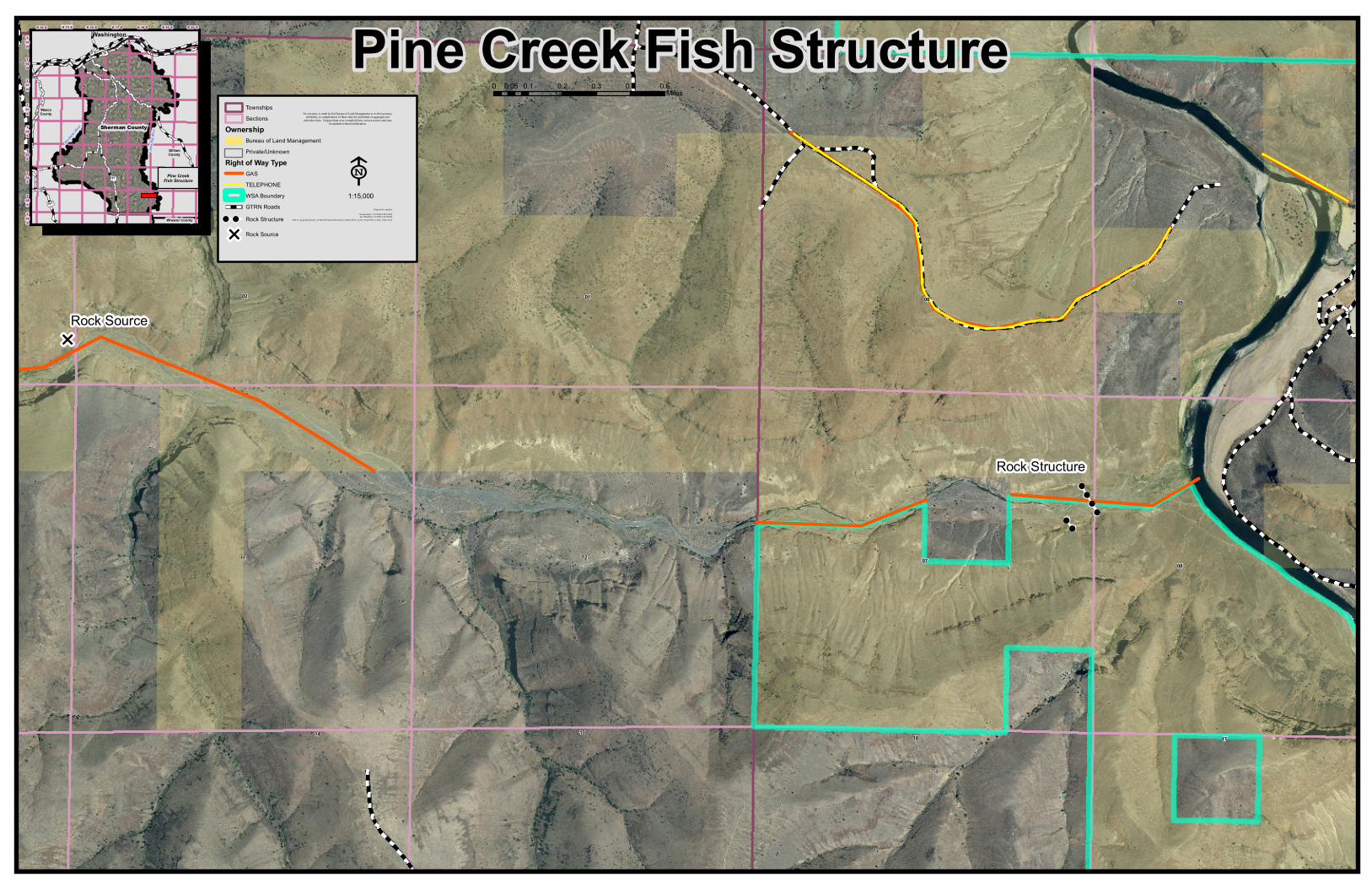
1.3 This project proposes to install a natural rock weir to stabilize the elevation of the stream
channel and allow for fish passage. The structure would be installed immediately downstream of the location where the exposed pipeline crosses the stream channel. See the attached map. The existing access road along the pipeline right of way would be used to haul native rocks to the site from nearby. The rocks would range in size from .5 to 4 feet in diameter. The rocks would be individually arranged and placed on the surface of the ground to build the structure. There would not be any excavation for the project. Some woody shrubs would be removed for rock placement. Any soil disturbance from

equipment installing the rocks would be leveled and reseeded. The rock structure would have sloping ramp at the active stream channel to allow for fish passage. See attached photos and drawings. Work would be performed during the approved low water work period for Mid-Columbia Steelhead streams. Late July to mid September.
1.4 This project is needed to provide for sustained fish passage. 1.5 The purpose of this project is to restore and maintain fish passage in lower 3 miles of the
stream channel in Pine Hollow Creek. The project would result in the aggradation of sediment and cobble behind the structure that would again cover the pipeline.
1.6 TransCanada Pipeline Company, ODFW, and BLM have cooperated in the proposal for this project. Oregon Department of State Lands, US Army Corps of Engineers and National Marine Fisheries Service have been consulted with. Consultation with the Confederated Tribes of the Warm Springs has also occurred.
1.7 The project site is habitat for Mid-Columbia Steelhead a listed species. The southern
edge of the pipeline right of way is the boundary for the North Pole Ridge WSA. 1.8 Conformance with Applicable Land Use Plan: This request is subject to and in
conformance with the Two Rivers Resource Management Plan, June 1986. It would meet the objective of providing fish/Riparian habitat improvements to achieve good to excellent aquatic habitat condition (page 11).
CHAPTER II. ALTERNATIVES INCLUDING THE PROPOSED ACTION 2.1 No Action Alternative: No action would be taken to address the fish passage barrier. 2.2 Proposed Action Alternative: This project proposes to install a natural rock weir to
stabilize the elevation of the stream channel and allow for fish passage. A contractor would be hired by the TransCanada Pipeline Company to install the weir. The structure would be installed immediately downstream of the location where the exposed pipeline crosses the stream channel. See the attached map. The existing access road along the pipeline right of way would be used to haul native rocks from a talus slope site about three miles west of the project site. The rocks would range in size from .5 to 4 feet in diameter. The rocks would be individually arranged and placed on the surface of the ground to build the structure. There would not be any excavation for the project. Some woody shrubs would be removed for rock placement. Any soil disturbance from equipment installing the rocks would be leveled and reseeded. The rock structure would have sloping ramp at the active stream channel to allow for fish passage. See attached drawings. Work would be performed during the approved low water work period for Mid-Columbia Steelhead streams. Late July to mid September.
CHAPTER III. AFFECTED ENVIRONMENT 3.1 Pine Hollow Creek flows from west to east into the John Day River at river mile 85. Pine
Hollow Creek provides habitat for Mid Columbia River Summer Steelhead (Onchorychus mykiss) which are currently listed as threatened. The lower end of Pine Hollow is a travel corridor to the head waters where spawning and rearing is taking place. Flows within the

creek are seasonal. Channel substrate is coarse gravel and cobble.
In 1960 a right of way was issued for the installation of a 36 inch natural gas pipeline to cross portions of the public lands through central Oregon. A portion of the pipeline was installed along Pine Hollow Creek. The pipeline was buried in the valley bottom parallel to and/or under the stream bed for approximately 5 miles. The creek channel in the vicinity of the project tends to meander throughout the floodplain. Over time the stream channel has scoured and exposed the pipeline. Where the water flows over the exposed pipeline a plunge pool has evolved. In low water flow situations the plunge pool is at an elevation compared to the pipeline that creates a barrier for juvenile fish passage.
Riparian vegetation is sparse only occurring near longer lasting pools. Vegetation in the floodplain is dominated by dry site species such as sagebrush and grass. The pipeline right of way forms the northern boundary of the North Pole Ridge Wilderness Study Area (WSA). At the project site, the right of way access road is south of the pipeline within the WSA. A portion of the fish habitat improvement project approximately 250 feet long would be within the WSA. Cultural resources were not found or expected at the project site. A copy of the cultural survey is on file at the Prineville BLM office. Cultural resources were found near the rock source site.
CHAPTER IV. ENVIRONMENTAL CONSEQUENCES 4.1 The effects of the no action alternative would be that a barrier to juvenile fish passage
would continue. The special value of aquatic habitat for Mid Columbia Steelhead for the WSA would continue to be degraded. Cultural resources would not be affected.
4.2 The effects on fish habitat and water quality of this proposal are positive overall. In the
short term there could be the potential for an increase of sediment. This is mitigated by working in the low water work window. The channel would be dry during the construction period and is composed of cobble substrate with very little fine sediment. The current state of Pine Hollow at the construction site is very poor. Lack of perennial flow and perennial riparian vegetation this site can not deviate any further from a fisheries standpoint. In the long term the structure would trap sediment behind it, covering the exposed pipeline. The sediment that is trapped should encourage the growth of perennial riparian vegetation and perennial flow. Potentially Pine Hollow Creek can be restored and returned to a properly functioning condition. The structure would provide fish passage for both adult and juvenile Mid Columbia River Summer Steelhead.
The analysis of effects of the project proposal on the WSA was conducted in accordance
with H-8850-1 - Interim Management Policy for Lands Under Wilderness Review (II.B.) A complete copy of the analysis is on file at the Prineville BLM office. The proposed project as designed does not impair the WSA’s suitability for preservation as wilderness. The proposed project enhances aquatic habitat for Mid Columbia summer steelhead which is one of the special features described in the WSA intensive inventory. Mitigations are included in the design of the project. The use of native rock, reseeding disturbances from equipment, and the design of the rock weir itself that catches bedload that diffuses the visual aspect of the rock weir all reduce the effects.

The effect to cultural resources is mitigated by avoidance of potential sites and by having a monitor on site during the project activities. Activities would be ceased if cultural resources are encountered.
4.3 Implementation monitoring would occur as the project progresses. Annual monitoring of
the effectiveness would be completed and reported as part of the programmatic consultation for Mid Columbia summer steelhead.
CHAPTER V. LIST OF PREPARERS, REVIEWERS, CONSULTATION AND COORDINATION Preparers:
Jeff Moss Fisheries, BLM John Zancanella, Cultural, BLM Berry Phelps, Wilderness, BLM Janet Hutchison, Realty Specialist, BLM Dan Tippy, Environmental Coordination, BLM Coordination: Oregon Department of Fish and Wildlife, Tim Unterwegner TransCanada GTN Systems, Steve McNulty URS Corporation, John Patrouch Geomax, Al Potter Consultation: US Army Corps of Engineers, Debra Henry Confederated Tribes of the Warm Springs NOAA Fisheries
CHAPTER VI. APPENDICES 1. Map of Project Area – 1 page 2. Rock Structure Drawing – 2 pages
!!!!
!!!!
!!
!!
E
Rock Source
Rock Structure
11 12 07
01 0602
08
05
131814 17
Pine Creek Fish Structure0 0.1 0.2 0.3 0.4 0.50.05
Miles
£¤97
£¤197
£¤30
R 14 E R 15 E R 16 E R 17 E R 18 E R 19 E R 20 EWashington
Sherman CountyWascoCounty
GilliamCounty
Wheeler County
Pine CreekFish Structure
John
Day
Rive
r
Deschutes
River
T02N
T01N
T01S
T02S
T03S
T04S
T05ST06S
T03N
E1:15,000
No warranty is made by the Bureau of Land Management as to the accuracy,reliability, or completeness of these data for individual or aggregate use
with other data. Original data were compiled from various sources and maybe updated without notification.
Mxd: K:\gisgroup\Summer_07\Mariah\Projects\Recreation_Projects\Pine_Creek_Pro ject\Pine_Creek_3Mar3.mxd
Prepared by: mdrakeCreation Date: 2/11/2008 2:28:25 PMLast Modified: 3/3/2008 2:22:08 PM
E
80%Transparency
TownshipsSections
OwnershipBureau of Land ManagementPrivate/Unknown
Right of Way TypeGASTELEPHONEWSA BoundaryGTRN Roads
!!! ! Rock Structure
Rock Source

