open space settlement analysis for the … · 1226 4.55 gordon's wood ... typology proposed...
TRANSCRIPT

Wycombe Open Spaces Framework – Appendix 2-2: Settlement Analysis for LCA Chepping Wye Valley
1
OPEN SPACE SETTLEMENT ANALYSIS FOR THE LOCAL COMMUNITY AREA (LCA) CHEPPING WYE VALLEY
(DISTRICT SOUTHEAST) CONTENTS: HAZLEMERE NORTH / KINGSHILL ............................................................................................... 2 HAZLEMERE SOUTH / TYLERS GREEN ....................................................................................... 8 WOOBURN GREEN....................................................................................................................... 14 BOURNE END / WOOBURN ......................................................................................................... 20 FLACKWELL HEATH .................................................................................................................... 26 RURAL AREAS.............................................................................................................................. 32

Wycombe Open Spaces Framework – Appendix 2-2: Settlement Analysis for LCA Chepping Wye Valley
2
HAZLEMERE NORTH / KINGSHILL
Open space provision Figure: Open spaces serving Hazlemere North / Kingshill

Wycombe Open Spaces Framework – Appendix 2-2: Settlement Analysis for LCA Chepping Wye Valley
3
Table: Open spaces serving Hazlemere North / Kingshill
Site ID
Area (ha) Name Owner Typology Prim_purp Sec_purp Access
Site quality
6 0.85 Four Ashes allotments Hugehenden PC Allotments Operational L & V Limited 0.00
1201 0.33 Georges Hill Amenity Space Windmill Estate Amenity Space
Informal Recreation L & V Limited 0.61
1202 0.3 Sanctuary Wood hazlemere pc Semi Natural L & V Biodiversity Unrestricted 0.82
1203 0.08 Hoppers Way Amenity Space bcc Amenity Space L & V
Informal Recreation Unrestricted 0.60
1204 0.25 The Warren Copse hazlemere pc Semi Natural L & V Biodiversity Unrestricted 0.59
1205 0.98 Great Kingshill Allotments hughenden parish council Allotments Operational None Limited 0.56
1206 0.2 Beaumont Way Amenity Space wdc Amenity Space L & V
Informal Recreation Unrestricted 0.53
1207 0.66 Cedar Park Wood Hazlemere PC Semi Natural Informal Recreation Biodiversity Unrestricted 0.69
1209 5.13 Hazlemere Recreation Ground wdc Outdoor Sports
Informal Recreation
Formal Recreation Unrestricted 0.68
1210 0.22 Mary's Mead Tree belt Hazlemere PC Green Corridor L & V Biodiversity Unrestricted 0.00
1211 1.27 Primrose Hill Amenity Space Hughenden parish council Amenity Space
Informal Recreation L & V Unrestricted 0.61
1212 0.41 Cedar Park County Middle School bcc Institutional
Formal Recreation L & V Limited 0.69
1213 0.85 Primrose Hill Allotments Hughenden parish council Allotments Operational L & V Limited 0.55
1214 0.68 WIDMER END COUNTY COMBINED SCHOOL bcc Institutional
Formal Recreation
Informal Recreation Restricted 0.66
1215 0.08 Cedar Avenue Amenity Space Hazlemere PC Amenity Space L & V None Unrestricted 0.76
1216 0.88 Western Dene Landscape Coridoor bcc Amenity Space L & V None Unrestricted 0.77
1217 4.04 Beaumont Way Open Space Hazlemere PC Amenity Space Informal Recreation Biodiversity Unrestricted 0.55
1218 0.63 Cedar Park Recreation Ground Hazlemere PC Park
Informal Recreation
Formal Recreation Unrestricted 0.52
1219 0.69 Common Road Fields unknown Amenity Space Informal Recreation L & V Unrestricted 0.56
1220 0.21 Badger Way Badger Wood unknown Semi Natural Biodiversity L & V Limited 0.00
1221 0.23 Cockpit Close Amenity Space wdc Amenity Space
Informal Recreation L & V Unrestricted 0.57
1223 3.04 Hazlemere Recreation Ground North
Hazlemere Parish Council Outdoor Sports
Formal Recreation
Informal Recreation Unrestricted 0.72
1224 0.88 Amersham Road Wood not known Semi Natural L & V Biodiversity Limited 0.61 1225 0.08 Stag Lane Pond bcc Operational Operational L & V Unrestricted 0.00
1226 4.55 Gordon's Wood gordon builders Semi Natural L & V Biodiversity Unrestricted 0.66
1227 0.13 Badger Way Play Area wdc Playground Formal Recreation
Informal Recreation Unrestricted 0.76
1228 2.06
GREAT KINGSHILL COMMON VILLAGE GREEN
hughenden Parish Council Common/Green
Formal Recreation
Informal Recreation Unrestricted 0.56
1229 0.21 Widmer End Tennis Club private Outdoor Sports Formal Recreation L & V Limited 0.74
1230 1.15 WIDMER END RECREATION GROUND
hughenden parish council Park
Formal Recreation
Informal Recreation Unrestricted 0.61
1231 0.24 Cedar Barn Allotments Hazlemere PC Allotments Operational L & V Limited 0.59
1232 15.7 Widmer Fields private Semi Natural Informal Recreation L & V Unrestricted 0.00
Note: rows in light grey indicate sites that are also used for formal outdoor sport.

Wycombe Open Spaces Framework – Appendix 2-2: Settlement Analysis for LCA Chepping Wye Valley
4
Table: Open space provision analysis for Hazlemere North / Kingshill
Typology Proposed
local standards (ha / 1000)
OS in no
OS in ha
Level of OS in ha / 1000
population
(restricted and unrestricted)
Unrestricted OS in no
Unrestricted OS in ha
Level of unrestricted
OS in ha / 1000
population
Population = 6,910
Allotments 0.23 4 2.62 0.38 n/a n/a n/a
Amenity Space 0.55 8 3.40 0.49 7 3.07 0.44
Churchyards / cemeteries
n/a 0 0 n/a 0 0 n/a
Commons / village greens
1.65 1 2.25 0.32 1 2.25 0.32
Gardens 0.04 0 0 0 0 0 0
Green Corridors n/a 1 0.22 n/a 1 0.22 n/a
Institutional n/a 2 3.21 n/a 0 0 n/a
Natural / semi-natural green spaces
3.2 7 22.47 3.25 5 21.46 3.10
Sites used for outdoor sports
1.86 total
(1.2 public, 0.66 private) 6 12.00 1.74 4 11.38 1.65
Parks 1.67 4 8.22 1.19 4 8.22 1.19
Playgrounds 0.68 facilities/
1000 5 n/a 0.72 facilities 5 n/a 0.72 facilities
Teen facilities 0.31 facilities/
1000 2 n/a 0.29 facilities 2 n/a 0.29 facilities
TOTAL 9.71 31 49.9 7.22 21 41.8 6.05
Please note: differences in the ‘OS in ha-Total’ and the sum of hectares of the individual typologies differs due to some sites being used for outdoor sport in addition to their other purposes.

Wycombe Open Spaces Framework – Appendix 2-2: Settlement Analysis for LCA Chepping Wye Valley
5
Figure: Site accessibility in Hazlemere North / Kingshill

Wycombe Open Spaces Framework – Appendix 2-2: Settlement Analysis for LCA Chepping Wye Valley
6
Figure: Access to play and teen provision in Hazlemere North / Kingshill

Wycombe Open Spaces Framework – Appendix 2-2: Settlement Analysis for LCA Chepping Wye Valley
7
Key findings for Hazlemere North / Kingshill
Quantity
▪ The open space provision for Hazlemere North / Kingshill is below district average and recommended local standard
▪ There are quantitative shortfalls in the categories gardens, parks and commons ▪ Some open space typologies are absent such as churchyards and gardens ▪ The allotment provision exceeds proposed local standards ▪ There are no quantitative shortfalls in play and teen facilities ▪ There is good provision of semi-natural spaces but most of these though publicly accessible are
privately owned and could be closed of from public use at any point in time
Accessibility
▪ Generally good overall distribution of open space ▪ Most open spaces offer unrestricted access with the exception of the school sites ▪ Amersham Hill road acts as a line of severance to movement to the South ▪ Good access to the surrounding countryside ▪ A localised play deficiency exists at the northern edge of Hazlemere ▪ A large proportion of open space is privately owned and continuing public access is not
guaranteed
Quality
▪ 26 of the 31 sites have been scored for their quality ▪ Quality scores vary between 52 – 82% with an average score of 64%, which is slightly below
district average ▪ Poorest scoring sites include Cedar Park Recreation Ground (1218) and Beaumont open
spaces (1206 and 1217), which are not fulfilling their potential ▪ Hazlemere Recreation Ground (1209) although not scoring badly requires qualitative
improvements to pitches and the pavilions
Possible options for improvement ▪ Improve quality of poorest scoring sites, Beaumont open spaces (1206 and 1217) and Cedar
Park Recreation Ground (1218) where some improvements have already taken place ▪ Improve quality of Hazlemere Recreation Ground (1209) to enable intensification of use.
Improvements to the other part of the site (1223) are already underway with a new pavilion currently being built.
▪ Ensure that public access to open spaces is maintained and enhanced in the long term A strategic and a local open space deficiency exist in this area.

Wycombe Open Spaces Framework – Appendix 2-2: Settlement Analysis for LCA Chepping Wye Valley
8
HAZLEMERE SOUTH / TYLERS GREEN
Open space provision Figure: Open spaces serving Tylers Green / Hazlemere South

Wycombe Open Spaces Framework – Appendix 2-2: Settlement Analysis for LCA Chepping Wye Valley
9
Table: Open spaces serving Tylers Green / Hazlemere South
1846 0.46 Holy Trinity Church Church of England Churchyard Operational L & V Unrestricted 0.00
1847 0.19 Cherry Tree Way West private Amenity Space Informal Recreation L & V Unrestricted 0.00
1848 0.22 Cherry Tree Way East private Amenity Space Informal Recreation L & V Unrestricted 0.00
Site ID
Area (ha) Name Owner Typology Prim_purp Sec_purp Access
Site quality
1406 1.56 Cock Lane Cemetery CPC Churchyard/ Cemeteries Operational
Informal Recreation Unrestricted 0.73
1801 0.04 Mountford Mews Open Space Vacant/ Derelict L & V Biodiversity Unrestricted 0.00
1802 2.56 Kingswood Field South Chepping Wyc. Parish Semi Natural L & V Biodiversity Limited 0.55
1803 0.05 The Pines Play Area wdc Playground Formal Recreation L & V Unrestricted 0.75
1804 0.85 ASHLEY DRIVE RECRERATION GROUND
Chepping Wyc. Parish Park Informal Recreation
Formal Recreation Unrestricted 0.52
1805 2.8 Kingswood Field North private Semi Natural Biodiversity L & V Unrestricted 0.00
1806 0.05 Beechlands play area Playground Formal Recreation Informal Recreation Unrestricted 0.70
1807 0.27 Axa Woodland private Semi Natural Biodiversity L & V Unrestricted 0.72
1808 0.13 TYLERS GREEN COUNTY FIRST SCOOL bcc Institutional Formal Recreation Biodiversity Unrestricted 0.82
1809 2.81 Axa Woodland wdc Semi Natural Biodiversity Informal Recreation Limited 0.56
1810 0.13 Axa Open Space private Semi Natural L & V Biodiversity Unrestricted 0.67
1811 0.58 Axa Open Space private Amenity Space L & V Informal Recreation Unrestricted 0.90
1812 0.18 Penn Common Chepping Wyc. Parish Amenity Space L & V None Unrestricted 0.00
1814 1.82 ROSE AVENUE RECREATION GROUND
Chepping Wyc. Parish Park Informal Recreation
Formal Recreation Unrestricted 0.51
1815 2.19 Penn Common Chepping Wyc. Parish Common/Green Informal Recreation L & V Unrestricted 0.88
1816 0.18 Axa Woodland private Semi Natural L & V Biodiversity Limited 0.73
1817 0.44 MANOR FARM COUNTY MIDDLE SCHOOL bcc Institutional Formal Recreation
Informal Recreation Restricted 0.61
1818 7.8 SIR WILLIAM RAMSAY SCHOOL bcc Institutional Formal Recreation
Informal Recreation Limited 0.58
1819 0.1 Chepping Close Amenity Space wdc Amenity Space L & V
Informal Recreation Unrestricted 0.63
1820 7.69 Penn Common Chepping Wyc. Parish Common/Green Informal Recreation Biodiversity Unrestricted 0.63
1821 1.05 TYLERS GREEN COUNTY MIDDLE SCHOOL bcc Institutional Formal Recreation Biodiversity Restricted 0.60
1822 0.79 HAZLEMERE CE COMBINED SCHOOL bcc Institutional Formal Recreation None Restricted 0.74
1823 0.22 Penn Road Woodland Common/ Green L & V Biodiversity Limited 0.66
1824 2.03 Hazlemere Golf Club Wood private Semi Natural Biodiversity Informal Recreation Restricted 0.53
1826 0.26 Penn Road Amenity Space bcc Amenity Space L & V L & V Unrestricted 0.85
1827 4.87 Queensway Open Space wdc Amenity Space Informal Recreation l & V Unrestricted 0.57
1828 0.77 Queensway Allotments Chepping Wyc. Parish Allotments Operational L & V Limited 0.56
1829 0.34 Penn Common Chepping Wyc. Parish Common/Green L & V Biodiversity Unrestricted 0.70
1831 0.34 Cock Lane Amenity Space bcc Green Corridor Informal Recreation L & V Unrestricted 0.77
1832 1.11 Tylers Green Allotments Chepping Wyc. Parish Allotments Operational L & V Limited 0.68
1833 0.01 Land at Elm Road (CL 203) bcc Common/Green L & V None Unrestricted 0.00
1834 0.43 Axa Amenity Space private Semi Natural L & V Biodiversity Unrestricted 0.70
1836 0.3 St Mary's Church church Churchyard/ Cemeteries L & V
Informal Recreation Unrestricted 0.84
1837 0.18 St Mary's Parish Churchyard Chepping Wyc. Parish
Churchyard/ Cemeteries Operational
Informal Recreation Unrestricted 0.85
1838 2.08 Penn School LB of Camden Institutional L & V
Formal Recreation Limited 0.62
1839 0.06 Penn Village Green thames water Amenity Space L & V None Unrestricted 0.00
1841 0.02 Land at Beacon Hill (CL202) Chepping Wyc. Parish Common/Green L & V
Informal Recreation Unrestricted 0.83
1842 0.19 Axa Amenity Space private Amenity Space L & V None Unrestricted 0.75
1844 74.36 Kingswood Chepping Wyc. Parish Semi Natural Informal Recreation L & V Unrestricted 0.61
1845 0.07 Kite Wood Rd Amenity Space wdc Amenity Space Informal Recreation L & V Unrestricted 0.00

Wycombe Open Spaces Framework – Appendix 2-2: Settlement Analysis for LCA Chepping Wye Valley
10
Table: Open space provision analysis for Tylers Green / Hazlemere South
Typology Proposed local
standards (ha / 1000)
OS in no
OS in ha
Level of OS in ha / 1000 population
(restricted and unrestricted)
Unrestricted OS in no
Unrestricted OS in ha
Level of unrestricted OS
in ha / 1000 population
Population = 8,969
Allotments 0.23 2 1.88 0.21 0 0 0
Amenity Space 0.55 10 6.72 0.75 10 6.72 0.75
Churchyards / cemeteries
n/a 4 2.44 n/a n/a n/a n/a
Commons / village greens
1.65 6 10.47 1.17 5 10.25 1.14
Gardens 0.04 0 0 0 0 n/a
Green Corridors n/a 1 0.34 0.04 1 0.34 0.04
Institutional n/a 6 18.61 2.07 0 0 n/a
Natural / semi-natural green spaces
3.2 9 85.57 9.54 5 77.99 8.70
Sites used for outdoor sports
1.86 total
(1.2 public, 0.66 private) 5 12.57 2.16 0 0 0
Parks 1.67 2 3.3 0.37 2 3.3 0.37
Playgrounds 0.68 facilities/
1000 4 n/a 0.44 facilities 4 n/a 0.44 facilities
Teen facilities 0.31 facilities/
1000 1 n/a 0.11 facilities 1 n/a 0.11 facilities
TOTAL 9.71 43 129.45 14.43 30 101.15 11.27
Please note: differences in the ‘OS in ha-Total’ and the sum of hectares of the individual typologies differs due to some sites being used for outdoor sport in addition to their other purposes.

Wycombe Open Spaces Framework – Appendix 2-2: Settlement Analysis for LCA Chepping Wye Valley
11
Figure: Site accessibility in Tylers Green / Hazlemere South

Wycombe Open Spaces Framework – Appendix 2-2: Settlement Analysis for LCA Chepping Wye Valley
12
Figure: Accessibility to play and teen facilities in Tylers Green / Hazlemere South

Wycombe Open Spaces Framework – Appendix 2-2: Settlement Analysis for LCA Chepping Wye Valley
13
Key findings for Tyler’s Green / Hazlemere South
Quantity
▪ The overall open space provision in this area is above the District average, which is mainly due to the large amount of semi-natural space of Kingswood (1844)
▪ Despite a good overall open space supply there is a shortfall in parks, publicly available outdoor sport facilities, play areas and teen facilities. The short supply of multi-functional space, outdoor sport and teen facilities is considered most critical. However, it should be noted that there is a private sports club (1813) at the eastern edge of the settlement, which is conveniently located for residents f but which has not been taken into account in this analysis because it is outside the district boundary.
Accessibility
▪ Most sites offer unrestricted access ▪ The sloping topography acts as a barrier in places ▪ Kingswood severs the settlement from the main urban areas of High Wycombe ▪ The southern part of Tylers Green appears particularly deficient in play and teen facilities
Quality
▪ 34 sites have been scored for their quality ▪ Quality scores vary between 45 – 90% with an average score of 68%, which is about average ▪ The two parks Ashley Drive Rec (1804) and Rose Avenue Rec (1814) score poorest because
they are not meeting their potential
Possible options for improvement ▪ Improve access to school sites to address open space deficiencies in outdoor sport ▪ Improve quality of Ashley Drive Recreation Ground (1804) to increase intensity of use for sport ▪ Improve quality of parks (Ashley Drive – 1804 and Rose Ave - 1814) as these form an important
multi-functional open space resource ▪ Improve access to and facilities of Hazlemere Recreation ground (1209 and 1223), which
adjoins the area to the northwest ▪ Maintain and improve quality of teen facility (1814) and aim to create another facility in one of
the other existing open spaces, e.g. Ashley Drive (1804). ▪ Maintain and improve quality of semi-natural spaces in particular with regard to biodiversity ▪ Maintain and improve quality of play facilities A strategic and a local open space deficiency exist in this area.

Wycombe Open Spaces Framework – Appendix 2-2: Settlement Analysis for LCA Chepping Wye Valley
14
WOOBURN GREEN
Open space provision Figure: Open spaces serving Wooburn Green

Wycombe Open Spaces Framework – Appendix 2-2: Settlement Analysis for LCA Chepping Wye Valley
15
Table: Open spaces serving Wooburn Green
Site ID
Area (ha) Name Owner Typology Prim_purp Sec_purp Access
Site quality
1901 2.8 WOOBURN PARK parish Semi Natural Biodiversity
Informal Recreation Unrestricted 0.68
1902 0.2 Glory Close Open Space wdc Amenity Space
Formal Recreation
Informal Recreation Unrestricted 0.52
1903 0.4 Five Acres River Walk wdc Amenity Space
Informal Recreation L & V Unrestricted 0.69
1904 0 Wooburn Village Green Memorial parish Garden L & V
Informal Recreation Unrestricted 0.89
1905 0.9 Wooburn Village Green parish Common/Green L & V
Informal Recreation Unrestricted 0.78
1906 0.8 Boundary Road Green Corridor bcc Amenity Space L & V
Informal Recreation Unrestricted 0.75
1907 0.3 Northcroft Open Space wdc Amenity Space L & V
Informal Recreation Unrestricted 0.69
1908 0.3 Glory Mill Open Space private Amenity Space L & V Biodiversity Unrestricted 0.78
1909 0.7 Watery Lane Open Space
Wdc (leased to parish Park L & V
Formal Recreation Unrestricted 0.68
1910 0.2 GLORY MILL SPORTS GROUND private
Outdoor Sports
Formal Recreation L & V Limited 0.80
1911 2.3 Wooburn Green Lakes private Semi Natural Biodiversity L & V Restricted 0.00
1912 0.8 THE MEADOWS COUNTY COMBINED SCHOOL bcc
Vacant/Derelict None None Restricted 0.00
1913 0.9 THE MEADOWS COUNTY COMBINED SCHOOL bcc Institutional
Formal Recreation None Restricted 0.72
1915 7.56 Wooburn Park parish Park Informal Recreation
Formal Recreation Unrestricted 0.59
Note: rows in light grey indicate sites that are also used for formal outdoor sport.

Wycombe Open Spaces Framework – Appendix 2-2: Settlement Analysis for LCA Chepping Wye Valley
16
Table: Open space provision analysis for Wooburn Green.
Typology Proposed local
standards (ha / 1000)
OS in no
OS in ha
Level of OS in ha / 1000 population
(restricted and unrestricted)
Unrestricted OS in no
Unrestricted OS in ha
Level of unrestricted OS
in ha / 1000 population
Population = 3,963
Amenity Space 0.55 4 1.78 0.45 4 1.78 0.45
Churchyards / cemeteries
n/a 0 0 n/a 0 0 0
Commons / village greens
1.65 1 0.93 0.23 1 0.93 0.23
Gardens 0.04 1 0.04 0.01 1 0.04 0.01
Institutional n/a 1 0.89 n/a 0 0 n/a
Natural / semi-natural green spaces
3.2 2 5.12 1.29 1 2.79 0.70
Sites used for outdoor sports
1.86 total
(1.2 public, 0.66
private) 3 8.65 2.18 1 7.56 1.91
Parks 1.67 2 9.61 2.42 2 9.61 2.42
Playgrounds
0.68 facilities/
1000 1 n/a 0.25 facilities 1 n/a 0.25 facilities
Vacant / Derelict n/a 1 0.82 0.20 0 0 n/a
TOTAL 9.71 14 21.68 5.44 10 15.31 3.86
Please note: differences in the ‘OS in ha-Total’ and the sum of hectares of the individual typologies differs due to some sites being used for outdoor sport in addition to their other purposes.

Wycombe Open Spaces Framework – Appendix 2-2: Settlement Analysis for LCA Chepping Wye Valley
17
Figure: Site accessibility in Wooburn Green

Wycombe Open Spaces Framework – Appendix 2-2: Settlement Analysis for LCA Chepping Wye Valley
18
Figure: Accessibility to play and teen facilities in Wooburn Green

Wycombe Open Spaces Framework – Appendix 2-2: Settlement Analysis for LCA Chepping Wye Valley
19
Key findings for Wooburn Green
Quantity
▪ The open space provision in Wooburn Green is below district average and proposed local standards even when both public and private spaces are taken into account
▪ Open spaces of the category allotments, playgrounds, teen facilities and green corridors are absent
▪ There are only two public playgrounds (Watery Lane – 1919 and Wooburn Park – 1915) associated with the development although a further restricted access play area exists in the Glory Mill development.
▪ There is a particular quantitative shortfall in semi-natural spaces and commons but the area adjoins the open countryside on two sides, so that this deficiency is not of concern
▪ Many amenity spaces are road verges with little recreational benefit ▪ Although there is no deficiency in parks when standards are applied, this is mainly due to
Wooburn Park, which is a large site and adjoins the settlement to the south. There is only little other publicly available space within the built-up area of the settlement.
Accessibility
▪ Play areas only exist at the northern and southern end leaving a void in the centre of the settlement
▪ The majority of the existing spaces are either not publicly available or comprise small road verges of little recreational value
▪ High traffic volumes along Wycombe Lane and at Wooburn Green act as a line of severance to movement in this area
Quality
▪ 12 of the 14 sites have been quality assessed ▪ Quality scores vary between 52 – 89% with an average score of 71%, which is above average ▪ Glory Close (1902) is the lowest scoring site
Possible options for improvement ▪ Integrate teen facility in one of the existing open spaces, e.g. Wooburn Park (1915) ▪ Improve access to school playing fields out of school hours, e.g. the Meadows County School
(1913) ▪ Integrate play and teen facilities in any larger new development in the area ▪ Encourage multi-functionality of existing spaces ▪ Improve access to PROW ▪ Increase allotment capacity if and when an opportunity arises, e.g. through conversion from a
different open space category A strategic and a local open space deficiency exist in this area.

Wycombe Open Spaces Framework – Appendix 2-2: Settlement Analysis for LCA Chepping Wye Valley
20
BOURNE END / WOOBURN
Open space provision Figure: Open spaces serving Bourne End / Wooburn

Wycombe Open Spaces Framework – Appendix 2-2: Settlement Analysis for LCA Chepping Wye Valley
21
Table: Open spaces serving Bourne End / Wooburn
Site ID
Area (ha) Name Owner Typology Prim_purp Sec_purp Access
Site quality
102 0.68 Blind Lane Open Space parish Park Informal Recreation
Formal Recreation Unrestricted 0.53
103 1.43 Hawks Hill private Semi Natural Biodiversity L & V Restricted 0.89
104 0.21 West Ridge Amenity Space unknown Amenity Space L & V Informal Recreation Unrestricted 0.81
105 1.19 Wooburn Green Cemetery parish Churchyard/ Cemeteries Operational
Informal Recreation Unrestricted 0.78
106 0.26 Fieldhead Gardens Amenity Space private Semi Natural
Informal Recreation L & V Unrestricted 0.63
107 0.2 Stratford Drive Reach unknown Amenity Space L & V Informal Recreation Unrestricted 0.75
108 0.83 Cherwell Road Amenity Space wdc Amenity Space L & V
Informal Recreation Unrestricted 0.78
109 10.18 Slate Meadow Amenity Space wdc Amenity Space
Informal Recreation L & V Unrestricted 0.00
110 0.04 Hawks Hill (CL266) Common bcc Common/Green L & V
Informal Recreation Unrestricted 0.77
111 0.12 Hawks Hill Road Verge bcc Amenity Space L & V Informal Recreation Unrestricted 0.82
112 0.1 Bourne End Civic Garden parish Garden L & V Informal Recreation Unrestricted 0.75
113 1.23 HEDSOR SOCIAL CLUB private Outdoor Sports Formal Recreation
Informal Recreation Unrestricted 0.69
114 0.19 WOOBURN PARK private Outdoor Sports Formal Recreation
Informal Recreation Limited 0.91
115 0.14 Burroughs Crescent Amenity Space unknown Amenity Space
Informal Recreation L & V Unrestricted 0.91
116 0.63 Chapman Lane Allotments parish Allotments Operational None Limited 0.69
117 0.61 Blind Lane Amenity Space bcc Amenity Space L & V Informal Recreation Unrestricted 0.69
118 0.42 Slate Meadow Riverside parish Green Corridor L & V Informal Recreation Unrestricted 0.62
119 1.19 CLAYTONS COUNTY COMBINED SCHOOL bcc Institutional
Formal Recreation
Informal Recreation Restricted 0.84
120 0.42 WESTFIELD SCHOOL bcc Institutional Formal Recreation
Informal Recreation Restricted 0.67
121 3.11 WYE VALLEY SCHOOL bcc Institutional Formal Recreation None Limited 0.61
122 1.39 BOURNE END RECREATION GROUND parish Park
Informal Recreation
Formal Recreation Unrestricted 0.57
123 2.0 SAPPERS PLAYING FIELD parish Park Informal Recreation
Formal Recreation Unrestricted 0.53
125 0.38 ST PAULS CE COMBINED SCHOOL bcc Institutional
Formal Recreation None Restricted 0.81
126 0.31 Wooburn Park Reach unknown Semi Natural L & V Biodiversity Unrestricted 0.67
127 0.49 Soho Mill Riverside Amenity Space private Semi Natural Biodiversity
Informal Recreation Unrestricted 0.64
128 0.34 St Paul's Churchyard church Churchyard/ Cemeteries
Informal Recreation Biodiversity Unrestricted 0.69
129 2.67 Slate Meadow southeast Semi Natural L & V Operational Restricted 0.00 130 1.25 Hedsor Road Allotments parish Allotments Operational L & V Restricted 0.00 131 1.20 Bourne End Allotments parish Allotments Operational L & V Restricted 0.00
132 0.08 Bridgestone Drive amenity space wdc Amenity Space L & V
Informal Recreation Unrestricted 0.00
Note: rows in light grey indicate sites that are also used for formal outdoor sport.

Wycombe Open Spaces Framework – Appendix 2-2: Settlement Analysis for LCA Chepping Wye Valley
22
Table: Open space provision in Bourne End / Wooburn. Typology Proposed
local standards (ha / 1000)
OS in no
OS in ha
Level of OS in ha / 1000 population
(restricted and unrestricted)
Unrestricted OS in no
Unrestricted OS in ha
Level of unrestricted OS
in ha / 1000 population
Population = 6,475
Allotments 0.23 3 3.11 0.48 0 0 0
Amenity Space 0.55 9 4.88 0.75 8 4.74 0.73
Churchyards / cemeteries
n/a 2 1.53 n/a 2 1.53 n/a
Commons / village greens
1.65 1 0.04 0.01 1 0.04 0.01
Gardens 0.04 1 0.1 0.02 1 0.1 0.02
Green Corridors n/a 1 0.42 n/a 1 0.42 n/a
Institutional n/a 4 5.52 n/a 0 0 n/a
Natural / semi-natural green spaces
3.2 5 10.03 1.55 3 1.03 0.16
Sites used for outdoor sports
1.86 total
(1.2 public, 0.66 private) 7 9.5 1.46 3 4.63 0.71
Parks 1.67 3 4.57 0.70 3 4.57 0.70
Playgrounds 0.68 facilities/
1000 3 n/a 0.46 facilities 2 n/a 0.3 facilities
Teen facilities 0.31 facilities/
1000 2 n/a 0.3 facilities 2 n/a 0.3 facilities
TOTAL 9.71 31 31.66 4.89 20 21.63 2.19
Please note: differences in the ‘OS in ha-Total’ and the sum of hectares of the individual typologies differs due to some sites being used for outdoor sport in addition to their other purposes.

Wycombe Open Spaces Framework – Appendix 2-2: Settlement Analysis for LCA Chepping Wye Valley
23
Figure: Site accessibility in Bourne End / Wooburn

Wycombe Open Spaces Framework – Appendix 2-2: Settlement Analysis for LCA Chepping Wye Valley
24
Figure: Accessibility to play and teen facilities in Wooburn / Bourne End
Wycombe Open Spaces Framework – Appendix 2-2: Settlement Analysis for LCA Chepping Wye Valley
25
Key findings for Bourne End / Wooburn
Quantity
▪ Bourne End’s provision in open space is below District average and below proposed local standards..
▪ There is a shortfall in all typologies with the exception of allotments and public amenity space. The lack of larger multi-functional open spaces is of particular concern. Shortfall in informal open spaces, such as semi-natural spaces and commons are not of concern since the settlement is surrounded by high-quality countryside.
▪ Many of the public amenity spaces are small and therefore limited in their use
Accessibility
▪ Parts of Bourne End are deficient in play and teen facilities ▪ There are only few open spaces in the southern and western part of Bourne End ▪ Open spaces within this settlement are generally rather small with the exception of Wooburn
Park (1915) and the publicly available part of Slate Meadow (109) ▪ The River Thames acts as a line of severance to south and west of Bourne End
Quality
▪ 25 sites have been quality scored ▪ The quality of open spaces is generally good. Scores range between 53 – 91% with an average
score of 72%, which is above district average.
Possible options for improvement ▪ Improve access to school grounds, e.g. Wye Valley School (121) to address deficiencies in
outdoor sport ▪ Increase quality of existing sports facilities to maximise use, e.g. through the installation of new
changing rooms at Bourne End Recreation Ground (122) and Sappers Field (123) ▪ Create additional teen facility, e.g. at Wooburn Park ▪ Maintain and improve quality of multi-functional spaces to maximise use (Blind Lane open
space-102, Bourne End Rec-122, Sappers Playing Field-123, Wooburn Park 1915) ▪ Create multi-functional open space if opportunity arises, e.g. at Slate Meadow ▪ Deficiency in semi-natural space is of lesser concern but improved access to countryside via
PROW (Public Rights Of Way network) could be considered. Such a deficiency could also be addressed through the creation of a country park in the Little Marlow Gravel Pits area
A strategic and a local open space deficiency exist in this area.

Wycombe Open Spaces Framework – Appendix 2-2: Settlement Analysis for LCA Chepping Wye Valley
26
FLACKWELL HEATH
Open space provision Figure: Open spaces serving Flackwell Heath

Wycombe Open Spaces Framework – Appendix 2-2: Settlement Analysis for LCA Chepping Wye Valley
27
Table: Open spaces serving Flackwell Heath
Site ID Area (ha) Name Owner Typology Prim_purp Sec_purp Access
Site quality
56 3.38 Amersham & Wycombe College sports ground private Outdoor Sports Formal Recreation Informal Recreation Restricted 0.00
201 1.49
CARRINGTON COUNTY MIDDLE AND FIRST SCHOOLS bcc Institutional Formal Recreation Informal Recreation Restricted 0.84
202 2.18 STRAIGHT BIT RECREATION GROUND parish Park Formal Recreation Informal Recreation Unrestricted 0.55
203 1.08 Juniper Hill County Combined School bcc Institutional Formal Recreation Informal Recreation Restricted 0.79
204 2.93 FLACKWELL HEATH CRICKET GROUND parish Outdoor Sports Formal Recreation Informal Recreation Unrestricted 0.71
205 0.6 Buckingham Way Amenity Space wdc Amenity Space L & V Informal Recreation Unrestricted 0.57
206 1.29 WILKS PARK FOOTBALL GROUND private Outdoor Sports Formal Recreation None Limited 0.79
207 2.91 Oak Wood private Semi Natural L & V Informal Recreation Unrestricted 0.74
208 0.03 Oak Wood Play Area wdc Playground Formal Recreation None Unrestricted 0.67
209 0.44 Cherry Close Open Space parish Amenity Space L & V Informal Recreation Unrestricted 0.68
210 0.72 Oak Wood Field private Amenity Space Informal Recreation L & V Unrestricted 0.61
211 1.52 Highlea Allotments parish Allotments Operational None Limited 0.72
212 14.5 Fennels Wood 2 private Semi Natural L & V Informal Recreation Unrestricted 0.79
213 0.76 Highlea Field private Vacant/Derelict Informal Recreation Operational Unrestricted 0.00
214 0.2 Highlea Hall private Operational Operational Informal Recreation Limited 0.00
215 0.25 Heath End Road Amenity Space BCC? Amenity Space L & V Informal Recreation Unrestricted 0.00
216 0.11 Juniper Lane Amenity Space BCC Amenity Space L & V Informal Recreation Unrestricted 0.00
217 0.14 Chiltern Green wdc Amenity Space L & V Informal Recreation Unrestricted 0.00
218 1.26 Carrington School Playing Field private Amenity Space Formal Recreation Informal Recreation Restricted 0.00
219 0.06 School Green
Chepping Wycombe Parish Amenity Space L & V Informal Recreation Unrestricted 0.00
220 0.03 Chapel Green
Chepping Wycombe Parish Civil Space L & V Informal Recreation Unrestricted 0.00
Note: rows in light grey indicate sites that are also used for formal outdoor sport.

Wycombe Open Spaces Framework – Appendix 2-2: Settlement Analysis for LCA Chepping Wye Valley
28
Table: Open space provision analysis for Flackwell Heath.
Please note: differences in the ‘OS in ha-Total’ and the sum of hectares of the individual typologies differs due to some sites being used for outdoor sport in addition to their other purposes.
Typology Proposed local
standards (ha / 1000)
OS in no
OS in ha
Level of OS in ha / 1000 population
(restricted and unrestricted)
Unrestricted OS in no
Unrestricted OS in ha
Level of unrestricted OS
in ha / 1000 population
Population = 5,874
Allotments 0.23 1 1.55 0.26 n/a n/a n/a
Amenity Space 0.55 8 1.76 0.61 7 2.32 0.39
Institutional n/a 2 2.21 0.38 n/a n/a n/a
Natural / semi-natural green spaces
3.2 3 18.13 3.09 2 17.37 2.96
Sites used for outdoor sports
1.86 total
(1.2 public, 0.66 private) 6 7.57 1.29 2 3.3 0.56
Operational n/a 1 0.2 0.03 n/a n/a n/a
Parks 1.67 1 2.18 0.37 1 2.18 0.37
Playgrounds 0.68 facilities/
1000 2 n/a 0.34 facilities 2 n/a 0.34 facilities
Teen facilities 0.31 facilities/
1000 1 n/a 0.17 facilities 1 n/a 0.17 facilities
TOTAL 9.71 21 35.65 6.07 13 24.86 4.23

Wycombe Open Spaces Framework – Appendix 2-2: Settlement Analysis for LCA Chepping Wye Valley
29
Figure: Site accessibility in Flackwell Heath

Wycombe Open Spaces Framework – Appendix 2-2: Settlement Analysis for LCA Chepping Wye Valley
30
Figure: Access to play and teen provision in Flackwell Heath

Wycombe Open Spaces Framework – Appendix 2-2: Settlement Analysis for LCA Chepping Wye Valley
31
Key findings for Flackwell Heath
Quantity
▪ Flackwell Heath’s provision in open space is below the District average and proposed local standards in almost all typologies with the exception of the categories amenity space, semi-natural open space and allotments
▪ Several typologies are absent from the settlement namely churchyards, gardens and commons/greens
▪ The analysis is slightly distorted by Fennels Wood (site 212), which though publicly accessible is privately owned and could be closed of from public use at any point in time
▪ The lack of multi-functional and formal unrestricted access sites such as parks, gardens, outdoor sports facilities and play and teen facilities are of particular concern
Accessibility
▪ Only two of the outdoor sport sites are publicly available ▪ There is a localised deficiency for play and teen facilities towards the south-eastern part of the
settlement ▪ Only few sites offer truly unrestricted access and use. The picture is slightly distorted by sites
204 and 212, which enable access but which don’t really offer unrestricted use.
Quality
▪ Only 12 of the 15 sites have been scored for their quality to date ▪ Quality scores range between 55 - 84 % with an average score of 70%, which is above District
average ▪ Multi-functional open spaces such as Straight Bit Recreation Ground (202) and Buckingham
Way amenity space (205) would particularly benefit from improvements.
Possible options for improvement ▪ Improve quality of sites in particular sites Straight Bit (202) and Buckingham Way (205) ▪ Improve multi-functionality of sites e.g. by including teen facilities ▪ Aim to create another multi-functional space by improving the facilities on an existing site – e.g.
by upgrading Flackwell Heath Cricket Ground (204) to a multi-functional site by introducing play onto the site. This could also work towards addressing the localised play deficiency at the south-eastern end of Flackwell Heath
▪ Maintain and improve access to the surrounding countryside ▪ Improve access to restricted outdoor sport sites A strategic and a local open space deficiency exist in this area.
Wycombe Open Spaces Framework – Appendix 2-2: Settlement Analysis for LCA Chepping Wye Valley
32
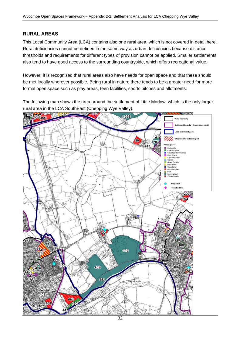
RURAL AREAS This Local Community Area (LCA) contains also one rural area, which is not covered in detail here. Rural deficiencies cannot be defined in the same way as urban deficiencies because distance thresholds and requirements for different types of provision cannot be applied. Smaller settlements also tend to have good access to the surrounding countryside, which offers recreational value. However, it is recognised that rural areas also have needs for open space and that these should be met locally wherever possible. Being rural in nature there tends to be a greater need for more formal open space such as play areas, teen facilities, sports pitches and allotments. The following map shows the area around the settlement of Little Marlow, which is the only larger rural area in the LCA SouthEast (Chepping Wye Valley).

Wycombe Open Spaces Framework – Appendix 2-2: Settlement Analysis for LCA Chepping Wye Valley
33
Key observations for the rural areas in LCA Chepping Wye Valley: • The area is located between the larger settlements of Marlow, Bourne End and Flackwell
Heath; • The only settlement in the area, Little Marlow, has access to open spaces locally; • Parts of the Little Marlow Gravel Pits have been recorded and make up large parts of the open
space provision in the area. However, most of these areas are restricted in access and offer therefore only limited opportunities for recreation.