open-file report no. neigc16c:b3 - digitalmaine
TRANSCRIPT
DEPARTMENT OF AGRICULTURE, CONSERVATION AND FORESTRY
Maine Geological Survey
Robert G. Marvinney, State Geologist
OPEN-FILE REPORT NO. NEIGC16C:B3
Title: Geomorphology of the Sheepscot River: Postglacial Evolution, Salmon
Habitat and Historic Dams
Author: Noah P. Snyder
Date: October 2016
Reprinted in color, by permission, from:
Berry, Henry N., IV, and West, David P., Jr., editors, 2016, Guidebook for field
trips along the Maine coast from Maquoit Bay to Muscongus Bay: New England
Intercollegiate Geological Conference, 108th Annual Meeting, October 14-16,
2016, Bath, Maine, 326 p.
Contents: 10 p. report
Recommended Citation: Snyder, Noah P., 2016, Geomorphology of the Sheepscot River:
Postglacial evolution, salmon habitat and historic dams: in Berry,
Henry N., IV, and West, David P., Jr., editors, Guidebook for field
trips along the Maine coast from Maquoit Bay to Muscongus Bay:
New England Intercollegiate Geological Conference, p. 155-164.


NEW ENGLAND INTERCOLLEGIATE
GEOLOGICAL CONFERENCE 108
th Annual Meeting
Guidebook for Field Trips along the Maine Coast
from Maquoit Bay to Muscongus Bay
Edited by
Henry N. Berry IV and
David P. West, Jr.
Hosted by
The Maine Geological Survey and
The Middlebury College Geology Department
October 14-16, 2016
ii
Copies of this guidebook, as long as they last, may be purchased
for $25 from the following address:
Geology Department
Middlebury College
276 Bicentennial Way
Middlebury, VT 05753
Cover Credit
The cover photograph is by Arthur M. Hussey II, to whom this guidebook is dedicated. Arthur
Hussey was an accomplished photographer and his numerous photo collections highlighted many
aspects of the natural beauty of southwestern Maine. The photo was taken by Arthur at a location
about a kilometer south of Lookout Point along the western shore of Harpswell Neck. Arthur first
began mapping in this area in 1962, and his 1965 NEIGC field trip visited exposures nearby. The
view in the photo is towards the south and the exposures are east-dipping metamorphosed
Ordovician volcanic rocks of the Cushing Formation. Arthur's hammer for scale.
The field guides for this Conference are offered under the terms of the Creative Commons
Attribution-Non-Commercial 3.0 Unported
DISCLAIMER
Before visiting any of the sites described in New England Intercollegiate Geological Conference guidebooks,
you must obtain permission from the current landowners.
Landowners only granted permission to visit these sites to the organizers of the original trips for the designated dates
of the conference. It is your responsibility to obtain permission for your visit. Be aware that this permission may
not be granted.
Especially when using older NEIGC guidebooks, note that locations may have changed drastically. Likewise,
geological interpretations may differ from current understandings.
Please respect any trip stops designated as "no hammers", "no collecting" or the like.
Consider possible hazards and use appropriate caution and safety equipment.
NEIGC and the hosts of these online guidebooks are not responsible for the use or misuse of the guidebooks.
Printed by Reprographics, Middlebury College, Middlebury, VT 05753
This document is printed on recycled paper
B3-1
GEOMORPHOLOGY OF THE SHEEPSCOT RIVER: POSTGLACIAL EVOLUTION, SALMON HABITAT AND HISTORIC DAMS
by
Noah P. Snyder, Department of Earth and Environmental Sciences, Boston College, Chestnut Hill, MA 02130 (e-mail: [email protected])
INTRODUCTION
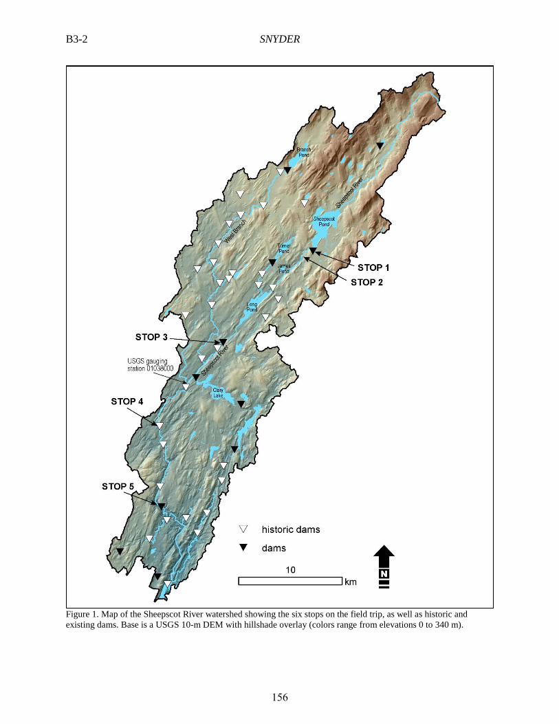
My research group has been working in the 554 km2 Sheepscot River watershed in Midcoast Maine since 2004
(Figure 1). The Sheepscot is one of the southernmost rivers in the U.S. that hosts native returning adult anadromous Atlantic salmon, and therefore has been the focus of salmon restoration projects and research activities by agencies (e.g., NRC, 2004; NOAA and USFWS, 2016), watershed-based non-profit groups (e.g., SVCA, 2005) and other scientists (Magilligan et al., 2007; Laser et al., 2009). My initial interest was to explore how relationships between geomorphic processes and salmon habitat, developed primarily from research in the Pacific Northwest (e.g., Montgomery, 2004), applied to rivers with Atlantic salmon in the northeastern U.S. The first project used marked bedload particles to study the conditions for entrainment (Snyder et al., 2009). Another project developed a model to use high-resolution lidar digital elevation models (DEMs; Snyder, 2009) to predict bed grain size, which is a vital control on salmon habitat quality and can be used to prioritize restoration efforts (Snyder et al., 2013). As I have become more interested in restoration and land-use history of New England (e.g., Snyder, 2012), my focus has shifted to the ongoing legacy of historic dams in the watershed, building the on the work by Walter and Merritts (2008) in the Mid-Atlantic region. Along the way, B.S. students Michelle Gryga (2006) and Susan Bresney (2011; Bresney et al., 2015) completed senior theses on the watershed, and M.S. students Michael Castele (2007), Andrew Nesheim (2011), Stephanie Castle (née Strouse, 2013), Austin Hopkins (2014; Hopkins and Snyder, 2016), and Kaitlin Johnson (2016) all wrote graduate theses. The goal of this fieldtrip is to visit sites along the main stem Sheepscot River and discuss some of the findings of these various projects.
STUDIES OF THE GEOMORPHOLOGY OF THE SHEEPSCOT RIVER
The Sheepscot River watershed is located within the Norumbega shear zone, which imparts a strong NE to SW
trend on the drainage pattern (Figures 1-2). Superimposed on this are glacial deposits, which have a more N-S trend. Most of the watershed below ~100 m elevation was inundated by the ocean during the late Pleistocene highstand, and therefore outcrops of Presumpscot Formation are common in the river valley. As with many rivers in Maine, the longitudinal profile of the Sheepscot River is a series of stairsteps: long low-gradient (slope < 0.05%) segments are broken up by short, high-gradient (slope > 0.2%) steps (Figure 3). The flat segments include morphologies from mainstem lakes to riparian wetlands to mud-to-sand bedded slow-flowing river segments (colloquially known as “deadwaters”). The location of steep gravel-bedded reaches is controlled by either outcrops of bedrock in the channel and/or glacial depositional features. These wide variations in slope lead to spatial diversity in bed grain size and Atlantic salmon habitat characteristics (Snyder et al., 2013). Moreover, the long low-gradient segments act as bedload sediment sinks, with sediment conveyed through steep segments deposited in fans that show up as concave reaches at the upstream end of flat segments on the longitudinal profile (Figure 3). The resulting discontinuous downstream-fining pattern has been described by Rice and Church (1998) in other postglacial settings. More recently, working in Vermont, Gartner et al. (2015) showed that reaches with decreasing stream power downstream (i.e. those with decreasing slope; concave) tend to be depositional during major flood events. This illustrates the trajectory of postglacial channels, with erosion in the steep reaches and deposition in the flat reaches, evolving toward a graded condition where bedload can be transported along the whole channel length. Of course, the timescale of this response is dependent on the supply of sediment available in the steep reaches, and in many places the flat reaches show little indication of deposition (e.g., Long Pond; Figures 1 and 3). In others, such as the wetland adjacent to James Pond, the deposition can been seen quite clearly in lidar imagery, with the river downcutting through glacial deposits (stops 1 and 2) and building a ramp across the partially filled lake basin downstream (Figures 2-3).
155
B3-2 SNYDER
Figure 1. Map of the Sheepscot River watershed showing the six stops on the field trip, as well as historic and existing dams. Base is a USGS 10-m DEM with hillshade overlay (colors range from elevations 0 to 340 m).
156
SNYDER B3-3
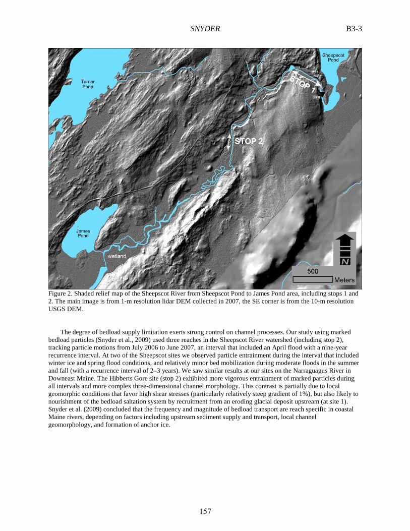
Figure 2. Shaded relief map of the Sheepscot River from Sheepscot Pond to James Pond area, including stops 1 and 2. The main image is from 1-m resolution lidar DEM collected in 2007, the SE corner is from the 10-m resolution USGS DEM.
The degree of bedload supply limitation exerts strong control on channel processes. Our study using marked
bedload particles (Snyder et al., 2009) used three reaches in the Sheepscot River watershed (including stop 2), tracking particle motions from July 2006 to June 2007, an interval that included an April flood with a nine-year recurrence interval. At two of the Sheepscot sites we observed particle entrainment during the interval that included winter ice and spring flood conditions, and relatively minor bed mobilization during moderate floods in the summer and fall (with a recurrence interval of 2–3 years). We saw similar results at our sites on the Narraguagus River in Downeast Maine. The Hibberts Gore site (stop 2) exhibited more vigorous entrainment of marked particles during all intervals and more complex three-dimensional channel morphology. This contrast is partially due to local geomorphic conditions that favor high shear stresses (particularly relatively steep gradient of 1%), but also likely to nourishment of the bedload saltation system by recruitment from an eroding glacial deposit upstream (at site 1). Snyder et al. (2009) concluded that the frequency and magnitude of bedload transport are reach specific in coastal Maine rivers, depending on factors including upstream sediment supply and transport, local channel geomorphology, and formation of anchor ice.
157

B3-4 SNYDER
Figure 3. Longitudinal profile of the Sheepscot River oriented upstream from the estuary (Sheepscot Road bridge) to Sheepscot Pond. Profile data are from a 1-m lidar DEM, smoothed with a moving average and spike-removing filters (black). Unprocessed data are shown in yellow; spikes are bridges or data errors in the original point cloud (at 21 km). Also included are locations of bedrock in the channel and bank, current and historic dams, as well as comparisons of grain size predictions with observations (Dpred/D50) from Snyder et al. (2013).
Getting an understanding of the controls on bedload transport in the Sheepscot River was a prerequisite for
developing a model to use inputs measured from digital elevation models (DEMs) to predict bed grain size based on the Shields equation (Snyder et al., 2013). The motivation for this work was to develop ways to use remote sensing data in a geographic information systems (GIS) context to guide restoration efforts focused on Atlantic salmon habitat (NRC, 2004). Adult Atlantic salmon spawn in rivers with gravel beds with a median grain size (D50) around 16 mm. After hatching, salmon require rearing habitat with good cover (e.g., large wood in the river) and coarser grain size (up to 256 mm). These habitat requirements motivate the development of models to predict bed grain size using GIS data (e.g., Buffington et al., 2004). Our approach involved measuring channel width, slope, and drainage area from lidar (1 m pixels) and traditional USGS (10 m pixels) DEMs, and using these parameters to predict the competent grain size at reaches spaced every 100 m along the channels. We tested the model predictions (Dpred) against field measurements of D50 using the Wolman (1954) method in three watersheds, including the Sheepscot. Overall, we found that the model correctly predicted observed bed grain size with a factor of two (Figure 3) in 70% of our measured locations, with better success where the bed is coarser. The model tended to overpredict grain size in reaches with sand or fine gravel beds, which was unsurprising because the model assumes a threshold, gravel-bed river that only mobilizes the bed during high-flow events (e.g., 2-year floods). Sand-bed rivers have more frequent sediment transport. The model was particularly successful in the most sediment-starved reaches, downstream of mainstem lakes, wetlands and deadwaters. We made field measurements of bed grain size in three segments of the
158
SNYDER B3-5
mainstem Sheepscot River (Figure 3; additional measurements were made along the West Branch; Snyder et al., 2013). The most notable result was decreasing success in the Hibberts Gore segment as it transitions to an anabranching, depositional system (stop 2). Overall, we interpreted the model failures in coarse-grained reaches to likely reflect a combination of factors that are not included in the models, including: (1) local variations in hydraulic roughness (caused by woody debris, beaver dams, and bed and bank vegetation); (2) variations in sediment supply and size caused by glacial geology and tributary inputs; and (3) environmental factors such as dams and road crossings. GIS-based grain-size prediction models can be used to guide restoration efforts by identifying reaches within a watershed where the predicted grain size is in a desirable range for anadromous fish habitat (Wilkins and Snyder, 2011). For instance, model outputs can be used to prioritize dam removals and culvert replacements to maximize fish access to reaches with high-quality habitat.
Currently, my research group is investigating the legacy of historic mill dams in the Sheepscot and other rivers in New England. This project is a collaboration with Dorothy Merritts and Robert Walter from Franklin and Marshall College. Walter and Merritts (2008; Merritts et al., 2011), have documented extensive storage of sediment associated with land clearing for agriculture and deposition in mill ponds in the present-day valley bottoms of the Mid-Atlantic Piedmont region. This builds on previous work in the region by Costa (1975) and Jacobson and Coleman (1986) that focused on post-settlement sedimentation due to land-use change. The goal of our collaboration is to quantitatively compare the volume of legacy sediment storage in selected watersheds in New England with similar settings in the Mid-Atlantic region. We hypothesize that New England may have less sediment storage due to (1) thinner hillslope soils (less available supply) and (2) more places to accumulate sediment in watersheds (e.g., lakes and wetlands). Relatively few studies have investigated anthropogenic valley-bottom sedimentation in postglacial New England. Bierman et al. (1997) used lakes and alluvial fans in Vermont to document increased sedimentation rates associated with land clearing. Thorson et al. (1998) documented extensive Colonial-era deposition in wetlands in a small Connecticut watershed.
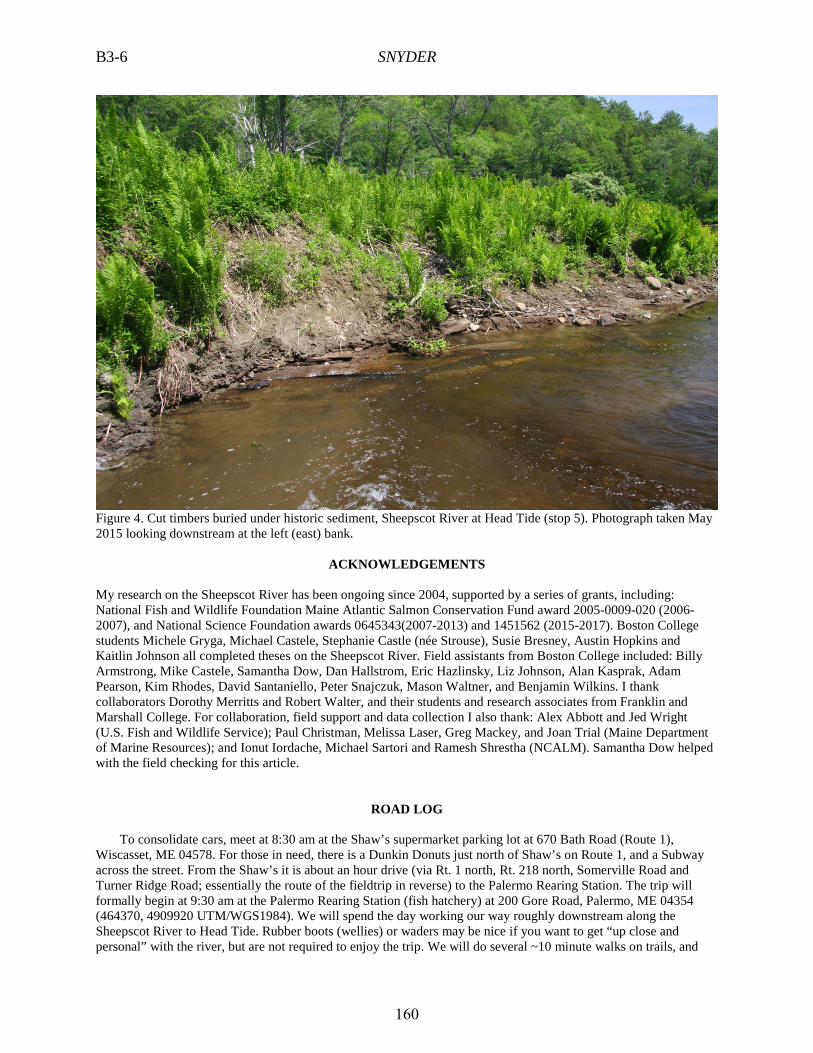
The Sheepscot River watershed hosted at least 44 mill dams during the 18th and 19th centuries, of which 11 remain (including at stops 1, 3 and 5). We have field checked 12 of the 44 dam sites, and find evidence for likely millpond sediment storage at six. Our most extensive work so far has been at the partially breached Head Tide Dam (stop 5), where up to 2.3 m of fine sand and silt is stored in bank outcrops on both sides of the river, in some places overlying a layer of planks and other cut wood associated with timber operations (Figure 4; Strouse, 2013; Hopkins, 2014; Hopkins and Snyder, 2016). A dam has existed at this site since the 1760s. Six radiocarbon dates from these deposits all return young (<300 yr) ages, indicating deposition during the period that the dam was in place. Unlike the Mid-Atlantic millpond deposits, we have not found a buried Holocene wetland or floodplain soil in any our study sites in the Sheepscot River watershed. In some places (including upstream of historic dams at stops 4 and 5), we find recently deposited silt and sand overlying the Presumpscot Formation directly. In other places we see fine-grained historic sediment overlying rounded gravel, which is likely the pre-disturbance river bed. Further work will focus on developing the Holocene to Anthropocene story in the watershed and elsewhere in the northeastern U.S.
159
B3-6 SNYDER
Figure 4. Cut timbers buried under historic sediment, Sheepscot River at Head Tide (stop 5). Photograph taken May 2015 looking downstream at the left (east) bank.
ACKNOWLEDGEMENTS
My research on the Sheepscot River has been ongoing since 2004, supported by a series of grants, including: National Fish and Wildlife Foundation Maine Atlantic Salmon Conservation Fund award 2005-0009-020 (2006-2007), and National Science Foundation awards 0645343(2007-2013) and 1451562 (2015-2017). Boston College students Michele Gryga, Michael Castele, Stephanie Castle (née Strouse), Susie Bresney, Austin Hopkins and Kaitlin Johnson all completed theses on the Sheepscot River. Field assistants from Boston College included: Billy Armstrong, Mike Castele, Samantha Dow, Dan Hallstrom, Eric Hazlinsky, Liz Johnson, Alan Kasprak, Adam Pearson, Kim Rhodes, David Santaniello, Peter Snajczuk, Mason Waltner, and Benjamin Wilkins. I thank collaborators Dorothy Merritts and Robert Walter, and their students and research associates from Franklin and Marshall College. For collaboration, field support and data collection I also thank: Alex Abbott and Jed Wright (U.S. Fish and Wildlife Service); Paul Christman, Melissa Laser, Greg Mackey, and Joan Trial (Maine Department of Marine Resources); and Ionut Iordache, Michael Sartori and Ramesh Shrestha (NCALM). Samantha Dow helped with the field checking for this article.
ROAD LOG To consolidate cars, meet at 8:30 am at the Shaw’s supermarket parking lot at 670 Bath Road (Route 1),
Wiscasset, ME 04578. For those in need, there is a Dunkin Donuts just north of Shaw’s on Route 1, and a Subway across the street. From the Shaw’s it is about an hour drive (via Rt. 1 north, Rt. 218 north, Somerville Road and Turner Ridge Road; essentially the route of the fieldtrip in reverse) to the Palermo Rearing Station. The trip will formally begin at 9:30 am at the Palermo Rearing Station (fish hatchery) at 200 Gore Road, Palermo, ME 04354 (464370, 4909920 UTM/WGS1984). We will spend the day working our way roughly downstream along the Sheepscot River to Head Tide. Rubber boots (wellies) or waders may be nice if you want to get “up close and personal” with the river, but are not required to enjoy the trip. We will do several ~10 minute walks on trails, and
160
SNYDER B3-7
spend much of the day next to (or in) the river. The trip will conclude with a bonus stop at the site of the Lower Montsweag Brook Dam removal in 2010, near Wiscasset, 0.7 mile SW of the Shaw’s supermarket on Route 1.
STOP 1: SHEEPSCOT RIVER AT THE SHEEPSCOT POND OUTLET. (60 MINUTES) river distance upstream (rkm): 47.4-46.9 slope: 1.3% From the fish hatchery parking lot, we will walk past the hatchery facilities (where brown trout and brook trout
are raised for stocking in Maine rivers) to the small outlet dam of Sheepscot Pond. We will discuss sediment starvation downstream of mainstem lakes. From there, we will make our way downstream to observe a ~10-m high actively eroding bank of glacial deposits (mapped as till) on the right (north) side of the river that supplies a wide range of grain sizes to the river downstream. Back at the cars, we will take one more look at the river as it makes a left bend under the Gore Road bridge.
Mileage 0.0 (464370 m E, 4909920 m N). Palermo Rearing Station parking lot. Start here. Drive west on Gore Road. 0.4 Turn left on Turner Ridge Road. 0.9 (463420 m E, 4909360 m N), Turn left into the parking lot of the Sheepscot Valley Conservation
Association Palermo Preserve. The parking lot is not large, so we will need to be efficient with parking our vehicles. STOP 2: SHEEPSCOT RIVER AT HIBBERTS GORE. (60 MINUTES) rkm: 45.4-45.1 slope: 1.0% From the preserve parking lot, we will walk ~10 minutes down an old road to the location of a former bridge
over the Sheepscot River. At this stop we will observe high-quality Atlantic salmon spawning and rearing habitat, including sorted bars ranging from coarse sand to cobbles in close proximity, widely varying depth due to scouring around large wood, and floodplain channels. Motivated by these characteristics, the SVCA sought to protect the land as a salmon preserve, and the Maine Department of Marine Resources has conducted various experiments in salmon restocking in this part of the river. This was the site of the most active bedload transport observed by Snyder et al. (2009), due to the relatively steep gradient (1.0%) of the river and the sediment supply provided by actively eroding glacial deposits upstream (stop 1). Downstream from this site, the river becomes anabranching as it builds a delta into the James Pond wetland (Figures 2-3), a location studied by Bresney et al. (2015). Impressive river engineering by beavers in 2016 will be a catalyst for ecogeomorphic discussion during the stop.
0.9 (463420 m E, 4909360 m N), Exit the parking lot left back on Turner Ridge Road. 3.6 Cross Maine Route 105 onto Somerville Road, which quickly becomes a two-lane dirt road. 8.4 At the first stop sign, go right on Main Street (unsigned). 8.8 (456080 m E, 4900740 m N), Park on Basin Lane (to the right) or along Main Street. STOP 3: COOPERS MILLS DAM. (30 MINUTES, plus time for lunch) rkm: 32.7-32.8 slope: 0.15% (in the reservoir and upstream) - 2.5% (downstream of the dam) Coopers Mills Dam is the lowermost intact dam on the mainstem river. In the 19th century at least seven dams
existed downstream from it (SVCA, 2005). This 6 m-high structure was built ca. 1824. It is in poor repair, and in January 2016, after nearly two decades of consideration, a Town of Whitefield committee unanimously decided to remove the dam. The project is expected to be completed by 2018. The Coopers Mills impoundment is noteworthy because it contains little evidence of sedimentation, which is unsurprisingly given its confined nature and position downstream of Long Pond. Measurements of river-bed elevations conducted for a hydraulic model show no obvious delta at the upstream end of the impoundment (Burke, 2016). 2.7 km downstream from this site, the West Branch joins the mainstem Sheepscot River, increasing the drainage area from 211 km2 to 343 km2.
We will have lunch in Coopers Mills. Those needing a bathroom break, coffee or a sandwich can make a run to Peaslee’s Quick Stop, just east (left) on Maine Route 32 from Coopers Mills.
8.8 (456080 m E, 4900740 m N), Turn around and go back (SE) on Main Street. 9.1 Turn right on Somerville Road. 9.2 Cross Maine Route 32 onto Maine Route 218. 12.2 -12.3 Do a left-right jig-jog at Maine Route 126 in North Whitefield, staying on Maine Route 218. 16.8 Cross the Sheepscot River at Whitefield and go left to stay on Maine Route 218. 16.9 Turn left on Kings Mills Lane.
161
B3-8 SNYDER
16.9 (450210 m E, 4890860 m N), Park in pull-out area on the left (3 vehicles) or along the left side of Maine Route 218.
STOP 4: SHEEPSCOT RIVER AT WHITEFIELD. (30 MINUTES) rkm: 17.8-17.5 slope: 0.03% (at bridge) – 1.8% (at dam site) Here we will take a quick look at the remnants of Kings Mills Dam. One or more dams existed at this location
since ca. 1774, and it was removed in the 1950s (SVCA, 2005). The 2-4 m high fill terraces (or floodplains) upstream of the Route 218 bridge were most likely influenced by sedimentation behind Kings Mills Dam. From here downstream to Head Tide the river enters a canyon 20-50 m deep, confined by an esker and the Presumpscot Formation. It is an exciting whitewater canoeing run at flows above 7 m3/s (250 cfs), with class I and II rapids.
16.9 (450210 m E, 4890860 m N), Turn around and turn left on Maine Route 218 (continuing south). 21.3 Turn left on Head Tide Road. 21.5 (450060 m E, 4884850 m N), Park in pull-out area on the left. STOP 5: SHEEPSCOT RIVER AT HEAD TIDE. (60 MINUTES) rkm: 10.8-10.4 slope: 0.16% (upstream of the dam) Head Tide Dam was constructed in the 1760s primarily to power a saw mill. A hole was cut into the modern
concrete structure in 1968 to facilitate passage by Atlantic salmon and other anadromous fish. Currently, the dam is being considered for full removal. The concrete structure is built directly on bedrock and the spillway is about 3 m high. During low flow, the dam exerts no base level control, but it does raise stage during high flow. We will first look at the dam, and then walk on a social trail upstream on the right (west) side of the river to look at bank outcrops of sediment deposited since the dam was constructed. Observations during and after high-flow events, as well as hydraulic modeling, indicate that the 1.5-2 m high floodplain still receives fine-grained sedimentation (Strouse, 2013). We will also observe a lower floodplain surface that is actively being constructed by a combination of sediment deposition and vegetation growth.
21.5 (450060 m E, 4884850 m N), Turn around and go back west on Head Tide Road. 21.6 Turn left on Maine Route 218. Drive to Wiscasset. 30.2 Turn right on U.S. Route 1. 33.5 Turn left into the Shaw’s parking lot. End of the Sheepscot River trip.
162
SNYDER B3-9
REFERENCES CITED
Bierman, P., A. Lini, P. Zehfuss, A. Church, P. T. Davis, J. Southon, and L. Baldwin, 1997, Postglacial ponds and alluvial fans: Recorders of Holocene landscape history, GSA Today, v. 7, n. 10.
Bresney, S.R., 2011, Patterns of Greenhouse Gas Production and Water Quality in High and Low Gradient Reaches of the Sheepscot River, Maine, BS thesis, Boston College.
Bresney, S.R., Moseman-Valtierra, S., and Snyder, N.P., 2015, Observations of greenhouse gases and nitrate concentrations in a Maine river and fringing wetland, Northeastern Naturalist, v. 22, n. 1, p. 120-143, doi: 10.1656/045.022.0125.
Buffington, J.M., Montgomery, D.R., and Greenberg, H.M., 2004, Basin-scale availability of salmonid spawning gravel as influenced by channel type and hydraulic roughness in mountain catchments, Canadian Journal of Fisheries and Aquatic Sciences, v. 61, p. 2085-2096, doi: 10.1139/F04-141.
Burke, M., 2016, Memorandum to the Coopers Mills Dam Committee, Interfluve, January 18, 2016, http://www.townofwhitefield.com/CoopersmillsDam/Long%20Pond%20Effects%20Evaluation%20011816%20Revised%20Final.pdf.
Castele, M.R., 2007, Modeling Sediment Transport and Quantifying Channel Morphology of the Sheepscot River, Coastal Maine, M.S. thesis, Boston College.
Costa, J., 1975, Effects of agriculture on erosion and sedimentation in Piedmont province, Maryland, Geological Society of America Bulletin, v. 86, n. 9, p. 1281-1286, doi:10.1130/0016-7606(1975)86<1281:EOAOEA>2.0.CO;2.
Gryga, M.E., 2006, Water Temperature Controls in the Sheepscot River, Maine, BS thesis, Boston College, http://hdl.handle.net/2345/414.
Hopkins, A.J., 2014, A Comparison of DEM-based Methods for Fluvial Terrace Mapping and Sediment Volume Calculation: Application to the Sheepscot River Watershed, Maine, MS thesis, Boston College, http://hdl.handle.net/2345/bc-ir:104046.
Hopkins, A.J., and Snyder, N.P., 2016, Performance evaluation of three DEM-based fluvial terrace mapping methods, Earth Surface Processes and Landforms, doi: 10.1002/esp.3922.
Jacobson, R. and D. Coleman, 1986, Stratigraphy and recent evolution of Maryland Piedmont flood plains, Am. J. Sci., v. 286, n. 8, p. 617-637.
Johnson, K., 2016, Quantifying Milldam Legacy Sediment Storage in Valley Bottoms of two New England Watersheds, M.S. thesis in preparation, Boston College.
Laser, M., Jordan, J., and Nislow, K.H., 2009, Riparian forest and instream large wood characteristics, West Branch Sheepscot River, Maine, USA, Forest Ecology and Management, v. 257, p. 1558–1565, doi:10.1016/j.foreco.2008.12.024.
Magilligan, F.J., Nislow, K.H., Fisher, G.B., Wright, J., Mackey, G., and Laser, M., 2008, The geomorphic function and characteristics of large woody debris in low gradient rivers, coastal Maine, USA: Geomorphology, v. 97, p. 467–482, doi:10.1016/j.geomorph.2007.08.016.
Merritts, D. J., R. C. Walter, M. Rahnis, J. Hartranft, S. Cox, A. Gellis, N. Potter, W. Hilgartner, M. Langland, L. Manion, C. Lippincott, S. Siddiqui, Z. Rehman, C. Scheid, L. Kratz, A. Shilling, M. Jenschke, K. Datin, E. Cranmer, A. Reed, D. Matuszewski, M. Voli, E. Ohlson, A. Neugebauer, A. Ahamed, C. Neal, A. Winter, and S. Becker, 2011, Anthropocene streams and base-level controls from historic dams in the unglaciated mid-Atlantic region, USA, Philosophical Transactions of the Royal Society A-Mathematical Physical and Engineering Sciences, v. 369, n. 1938, p. 976-1009, doi:10.1098/rsta.2010.0335.
Montgomery, D.R., 2004, Geology, geomorphology, and the restoration ecology of salmon, GSA Today, v. 14, no. 11, p. 4-12.
National Oceanic and Atmospheric Administration (NOAA) and U.S. Fish and Wildlife Service (USFWS), 2016, Recovery Plan for the Gulf of Maine Distinct Population Segment of Atlantic Salmon, http://www.fisheries.noaa.gov/pr/pdfs/20160329_atlantic_salmon_draft_recovery_plan.pdf.
Nesheim, A.O., 2011, Predicting Bed Grain Size in Maine Rivers Using Lidar Topographic Data, MS thesis, Boston College, http://hdl.handle.net/2345/2364.
Sheepscot Valley Conservation Association (SVCA), 2005, KRIS Sheepscot, http://www.krisweb.com/krissheepscot/krisdb/html/krisweb/index.htm.
Snyder, N.P., 2009, Studying stream morphology with airborne laser elevation data: Eos (Transactions, American Geophysical Union), v. 90, p. 45–46, doi: 10.1029/2009EO060001.
Snyder, N.P., 2012, Restoring geomorphic resilience in streams, in Church, M., Biron, P.M. and Roy, A.G., eds., Gravel-Bed Rivers: Processes, Tools, Environments, Chichester, West Sussex, UK, John Wiley and
163
B3-10 SNYDER
Snyder, N.P., Castele, M.R., and Wright, J.R., 2009, Bedload entrainment in low-gradient paraglacial coastal rivers of Maine, U.S.A.: Implications for habitat restoration, Geomorphology, v. 103, p. 430–446, doi:10.1016/j.geomorph.2008.07.013.
Strouse, S., 2013, The Effect of Millponds on Sedimentation in a Post-Glacial Mid-Coast Maine River Valley, MS thesis, Boston College, http://hdl.handle.net/2345/2970.
Thorson, R.M., Harris, A.G., Harris, S.L., Gradie, R. and Lefor, M.W., 1998, Colonial impacts to wetlands in Lebanon, Connecticut, Reviews in Engineering Geology, v. 12, p.23-42.
Walter, R. C. and D. J. Merritts, 2008, Natural streams and the legacy of water-powered mills, Science, v. 319, p. 299-304.
Wilkins, B.C., and Snyder, N.P., 2011, Geomorphic comparison of two Atlantic coastal rivers: Toward an understanding of physical controls on Atlantic salmon habitat, River Research and Applications, v. 27, p. 135, doi:10.1002/rra.1343.
Wolman, M.G., 1954, A method of sampling coarse river-bed material, American Geophysical Union, Transactions, v. 35, p. 951-956.
164