ontario land cover compilation data specifications version 2 la… · 1.0 data specifications sheet...
TRANSCRIPT
Ontario Land Cover Compilation Data Specifications Version 2.0
November 2014

2
Contact : Forest Resources Inventory Unit Coordinator, Science and Research Branch, Ontario Ministry of Natural Resources and Forestry. (705) 946-7450
Disclaimer This instructional documentation has been prepared by Her Majesty the Queen in right of Ontario as represented by the Minister of Natural Resources and Forestry (the “Ministry”). No warranties or representations, express or implied, statutory or otherwise shall apply or are being made by the Ministry with respect to the documentation, its accuracy or its completeness. In no event will the Ministry be liable or responsible for any lost profits, loss of revenue or earnings, claims by third parties or for any economic, indirect, special, incidental, consequential or exemplary damage resulting from any errors, inaccuracies or omissions in this documentation; and in no event will the Ministry’s liability for any such errors, inaccuracies or omissions on any particular claim, proceeding or action, exceed the actual consideration paid by the claimant involved to the Ministry for the materials to which this instructional documentation relates. Save and except for the liability expressly provided for above, the Ministry shall have no obligation, duty or liability whatsoever in contract, tort or otherwise, including any liability or negligence. The limitations, exclusions and disclaimers expressed above shall apply irrespective of the nature of any cause of action, demand or action, including but not limited to breach of contract, negligence, strict liability, tort or any other legal theory, and shall survive any fundamental breach or breaches.

3
Table of Contents 1.0 Data Specifications Sheet .............................................................................................................4
2.0 Ontario Land Cover Classification.......................................................................................................5
2.1 Overview ..........................................................................................................................5
2.2 Source Land Cover Databases ...........................................................................................6
2.3 Data Dictionary .............................................................................................................................6
3.0 References ..................................................................................................................................... 19
4
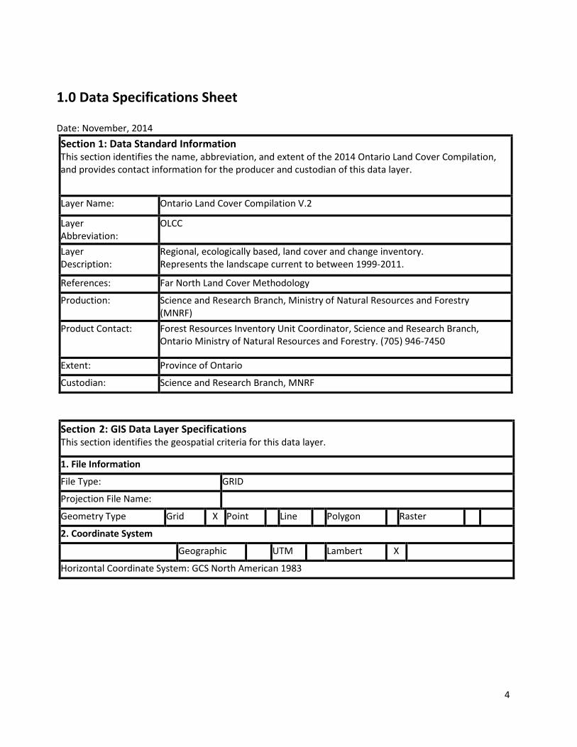
1.0 Data Specifications Sheet Date: November, 2014 Section 1: Data Standard Information This section identifies the name, abbreviation, and extent of the 2014 Ontario Land Cover Compilation, and provides contact information for the producer and custodian of this data layer.
Layer Name: Ontario Land Cover Compilation V.2
Layer Abbreviation:
OLCC
Layer Description:
Regional, ecologically based, land cover and change inventory. Represents the landscape current to between 1999-2011.
References: Far North Land Cover Methodology
Production: Science and Research Branch, Ministry of Natural Resources and Forestry (MNRF)
Product Contact: Forest Resources Inventory Unit Coordinator, Science and Research Branch, Ontario Ministry of Natural Resources and Forestry. (705) 946-7450
Extent: Province of Ontario
Custodian: Science and Research Branch, MNRF Section 2: GIS Data Layer Specifications This section identifies the geospatial criteria for this data layer.
1. File Information
File Type: GRID
Projection File Name:
Geometry Type Grid X Point Line Polygon Raster
2. Coordinate System
Geographic UTM Lambert X
Horizontal Coordinate System: GCS North American 1983

5
2.0 Ontario Land Cover Classification V.2
2.1 Overview The Ontario Land Cover Compilation serves as a consistent land cover map for the entire province to meet regional - to - landscape level analysis (1:50,000 – 1:100,000). This product is comprised of three separate land cover databases, each with separate class structures and which have been rationalized into a single classification.
Figure 1: (a) Ontario Land Cover Compilation and (b) Source Land Cover Databases
The Ontario Land Cover Compilation consists of 29 land cover classes derived by combining the Provincial Land Cover Database (2000 Edition), Far North Land Cover Version 1.4 and the Southern Ontario Land Resource Information System (Version 1.2). Each of these separate land cover databases was resampled to a common pixel spacing (15 metres), re-projected to a common projection (NAD83 Lambert Conformal Conic) and reclassified into a common class structure. The reclassification scheme is described in section 2.3 of this data specification document.

6
2.2 Source Land Cover Databases The Provincial Land Cover Database (2000 Edition)
(PLC2000)
This database consists of 27 broad land cover types and was produced in 2004 from an unsupervised classification of approximately 55 Landsat-7 ETM satellite images acquired between 1999 and 2002. The PLC2000 was produced as 4 overlapping rasters, one for each UTM zone within the province, with a pixel resolution of 25 metres.
Southern Ontario Land Resource Information System (SOLRIS) Version 1.2 (SOLRISv1.2)
The SOLRIS database consists of 25 land cover classes which follow the Ministry of Natural Resources’ Ecological Land Classification (ELC) for southern Ontario. This database was produced in 2008 from an object oriented classification of 11 Landsat-7 ETM satellite images acquired between 1999 and 2002. SOLRIS was produced as 2 overlapping rasters, one for each UTM zone in southern Ontario, with a pixel resolution of 15 metres.
Far North Land Cover Version 1.4 (FNLCv1.4)
The Far North Land Cover consists of 26 land cover types and was updated in 2014 from an object oriented classification of Landsat-5 TM satellite images acquired between 2005 and 2011. The FNLC was produced as 3 overlapping rasters, one for each UTM zone in northern Ontario, with a pixel resolution of 30 metres. 2.3 Data Dictionary
The following table is provided as a data dictionary for the Ontario Land Cover Compilation. For each class, the class name, code number and the source land cover class and class description are included. For more details on the source land cover products, including potential class confusions, please refer to the corresponding data dictionaries of these products.

7
Table 1: Ontario Land Cover Compilation Classification As Related to the Source Land Cover Classifications
Unit Name Code #
Source Unit Name Source Unit Description
Clear Open Water
1 PLC2000: Water – deep clear Water – deep clear: Deep or clear waterbodies. SOLRIS v1.2: Open Water Open Water: No macrophyte vegetation, trees or shrub cover FNLC v1.4: Clear Open Water
Clear Open Water: This class is characterized by water with minimal or no evidence of turbidity or sediment. There is also an absence of macrophyte vegetation, tree or shrub cover.
Turbid Water 2 PLC2000: Water – shallow / sedimented
Water – shallow / sedimented: Shallow waterbodies and waterbodies with a high concentration of suspended sediment.
SOLRIS v1.2: - FNLC v1.4: Turbid Water Turbid Water: This class is characterized by water with varying degrees of turbidity,
sediment and marl. Sparse floating and submerged vegetation is also included in this class as tones are similar to water with turbidity and sediment. Little to no tree or shrub cover is present. The mixture of sparse emergent and floating vegetation, suspended sediment, turbid water and clear water create a unique and identifiable image tone.
Shoreline 3 PLC2000: - SOLRIS v1.2: Shoreline; Open Shoreline
Shoreline; Open Shoreline: Substrate consists of unconsolidated parent or mineral material. Subject to active processes / < 25% vegetative cover
FNLC v1.4: - Mudflats 4 PLC2000: Mudflats Mudflats: Unvegetated coastal areas of the Hudson Bay-James Bay Lowlands, partly
submerged at high tide. SOLRIS v1.2: - FNLC v1.4: Intertidal Mudflat
Intertidal Mudflat: Completely unvegetated coastal areas of Hudson and James Bays. These features are covered by varying depths of water depending on distance from the coast, as well as the point in the tidal cycle when the imagery was acquired. These features have a unique and identifiable image tone due to the combination of wet and exposed soil. Proximity to James and Hudson Bays also aids detection.

8
Unit Name Code
# Source Unit Name Source Unit Description
Marsh 5 PLC2000: Marsh – intertidal; Marsh – supertidal
Marsh – intertidal: Coastal marshes of the Hudson Bay-James Bay Lowlands lying between the coastal mudflats and the supertidal zone. Marsh – supertidal: Coastal marshes of the Hudson Bay-James Bay Lowlands lying inland of both the coastal mudflats and intertidal marshes, and subject to only exceptionally high tides.
SOLRIS v1.2: Marsh Marsh: Open, shrub and treed communities - water table seasonally or permanently at, near, or above substrate surface - tree and shrub cover ≤ 25% - dominated by emergent hydrophytic macrophytes
FNLC v1.4: Intertidal Marsh; Supertidal Marsh; Fresh Water Marsh
Intertidal Marsh: Primarily open communities containing living and senesced grasses, sedges and emergents. These marshes are directly adjacent to the Hudson and James Bay coasts between mudflats and the supertidal zone, and are constantly influenced by brackish and freshwater. They are flooded at high tide and slowly drain as the tide falls; a process that leaves a mosaic of pools of standing water. Estuarine intertidal marshes are found at the outflows of freshwater rivers and are also included in this class. Last year’s dead vegetation is sometimes present while fluctuating water levels and other natural disturbance (e.g. overgrazing by abnormally high geese populations) can also stress vegetation in this zone causing it to senesce early. A combination of higher amounts of dead and senesced grasses and heterogeneous conditions provide a unique mosaic of image tones that allows for mapping. Proximity to James and Hudson Bays also aids detection. Supertidal Marsh: Primarily open communities containing some shrubs and trees. Tree and shrub cover ≤ 25% and dominated by emergent hydrophytic macrophytes. Water table is seasonally or permanently at, near, or above substrate surface. This class includes coastal marshes beyond the intertidal zone and as such, subjected to salt water via exceptional tides and storm surges. Lower amounts of visible sensed vegetation and water along with proximity to James and Hudson Bays allows for image detection.

9
Unit Name Code
# Source Unit Name Source Unit Description
FNLC v1.4: Intertidal Marsh; Supertidal Marsh; Fresh Water Marsh (Cont’d)
Fresh Water Marsh: Fresh water marshes occur in close proximity to Hudson and James Bays. They are often adjacent to supertidal marshes but not subjected to any salt water influences. Otherwise, freshwater marsh features are relatively rare in the Far North but do occur. When they occur these features are located on inland lakes and rivers in the southern portion of the Ontario Shield and in river oxbows in the Hudson Bay lowlands. These are generally open communities where the water table is seasonally or permanently at, near, or above substrate surface. Vegetation is composed primarily of grasses, sedges and emergents while tree and shrub cover ≤ 25%.
Swamp 6 PLC2000: Swamp – deciduous; Swamp - coniferous
Swamp – deciduous: Hardwood swamps of Southern Ontario occurring along rivers and in old lakebeds and other low-lying areas. Swamp – coniferous: Swamps with dense conifer tree or shrub cover occurring in Southern Ontario.
SOLRIS v1.2: Swamp Swamp: Open, shrub and treed communities - water table seasonally or permanently at, near, or above substrate surface - tree or shrub cover > 25% - dominated by hydrophytic shrub and tree species
FNLC v1.4: Thicket Swamp; Coniferous Swamp; Deciduous Swamp
Thicket Swamp: Greater than 25% hydrophytic shrub species capable of growing taller than 2 metres and tree cover less than 10%. These are typically found within or on the edges of small to large flowing water bodies and in supertidal portions of the Hudson Bay Lowlands. Their mineral or organic soil is subject to seasonal flooding or characterized by a high water table. In many cases a circulation of water rich in dissolved minerals allows for dense vegetation growth. Their association to water and unique image tones due to high deciduous leaf densities enables mapping. Coniferous Swamp: Greater than 25% hydrophytic shrub and/or coniferous tree species. Their mineral or organic soil is subject to seasonal flooding or characterized by a high water table and a circulation of water rich in dissolved minerals. Hydrologically these features exist in isolated depressions or adjacent to streams, lakes, fens or bogs.

10
Unit Name Code
# Source Unit Name Source Unit Description
FNLC v1.4: Thicket Swamp; Coniferous Swamp; Deciduous Swamp (Cont’d)
Deciduous Swamp: Greater than 25% hydrophytic shrub and deciduous tree species. The tree cover mostly deciduous is greater than 10%. Their mineral or peaty phase substrate is subject to seasonal flooding or characterized by a high water table and a circulation of water rich in dissolved minerals. Hydrologically these features exist in depressions or level slope, adjacent to lakes, streams and rivers, or open peatlands.
Fen 7 PLC2000: Fen – open; Fen - treed
Fen – open: Fens generally lacking tree cover that may support some shrub cover and tamarack. Open fens include fens with an open water surface, graminoid fens, pattern fens, and shrub-rich fens.
Fen – treed: Fens supporting a sparse to dense cover of trees or shrubs.
SOLRIS v1.2: Fen Fen: Open, shrub and treed communities - water table seasonally or permanently at, near, or above substrate surface. - tree cover (trees > 2m high) ≤ 25% - sedges, grasses and low (< 2 m) shrubs dominate, sedge and brown moss peat substrate
FNLC v1.4: Open Fen; Treed Fen
Open Fen: Fens develop in areas of generally slow flowing water and often have saturated or flooded surfaces. These features are fed by water from precipitation, ground and/or surface water, with the latter two sources enriched by contact with surrounding mineral soils. These conditions enable slightly more vegetative diversity and density than bogs. Mosses (generally not sphagnum), graminoids and low ericaceous shrubs are all common. Tall shrubs may also be present but at densities of less than 25%. Conditions such as open water surfaces and saturation, dense graminoids, string patterns and textured ericaceous shrub-rich communities all aid their remote detection. Additionally, low tree cover, approximately zero to 10%, also aids identification.
Treed Fen: As described above fens receive ground and surface water. These conditions allow for slightly higher vegetation density than bogs. Tamarack is usually associated with fens due to its adaptation to the telluric conditions common in this wetland type. At densities predominately over 10%, trees display a unique image tone that, when combined with the other observable conditions noted for open fen, allow for their detection on imagery. Black spruce is also present in these features, but not typically used as an image identifier as these trees are also evident in several other land cover classes.
11
Unit Name Code
# Source Unit Name Source Unit Description
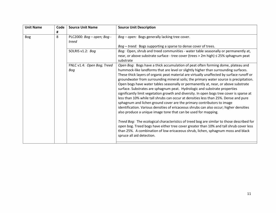
Bog 8 PLC2000: Bog – open; Bog - treed
Bog – open: Bogs generally lacking tree cover.
Bog – treed: Bogs supporting a sparse to dense cover of trees. SOLRIS v1.2: Bog Bog: Open, shrub and treed communities - water table seasonally or permanently at,
near, or above substrate surface - tree cover (trees > 2m high) ≤ 25% sphagnum peat substrate
FNLC v1.4: Open Bog; Treed Bog
Open Bog: Bogs have a thick accumulation of peat often forming dome, plateau and hummock-like landforms that are level or slightly higher than surrounding surfaces. These thick layers of organic peat material are virtually unaffected by surface runoff or groundwater from surrounding mineral soils; the primary water source is precipitation. Open bogs have water tables seasonally or permanently at, near, or above substrate surface. Substrates are sphagnum peat. Hydrologic and substrate properties significantly limit vegetation growth and diversity. In open bogs tree cover is sparse at less than 10% while tall shrubs can occur at densities less than 25%. Dense and pure sphagnum and lichen ground cover are the primary contributors to image identification. Various densities of ericaceous shrubs can also occur; higher densities also produce a unique image tone that can be used for mapping.
Treed Bog: The ecological characteristics of treed bog are similar to those described for open bog. Treed bogs have either tree cover greater than 10% and tall shrub cover less than 25%. A combination of low ericaceous shrub, lichen, sphagnum moss and black spruce all aid detection.
12
Unit Name Code #
Source Unit Name Source Unit Description
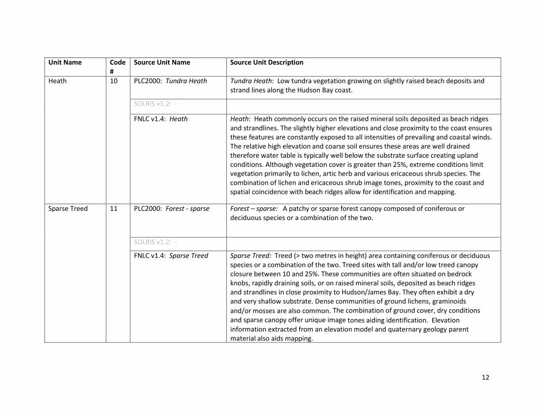
Heath 10 PLC2000: Tundra Heath Tundra Heath: Low tundra vegetation growing on slightly raised beach deposits and strand lines along the Hudson Bay coast.
SOLRIS v1.2: -
FNLC v1.4: Heath Heath: Heath commonly occurs on the raised mineral soils deposited as beach ridges and strandlines. The slightly higher elevations and close proximity to the coast ensures these features are constantly exposed to all intensities of prevailing and coastal winds. The relative high elevation and coarse soil ensures these areas are well drained therefore water table is typically well below the substrate surface creating upland conditions. Although vegetation cover is greater than 25%, extreme conditions limit vegetation primarily to lichen, artic herb and various ericaceous shrub species. The combination of lichen and ericaceous shrub image tones, proximity to the coast and spatial coincidence with beach ridges allow for identification and mapping.
Sparse Treed 11 PLC2000: Forest - sparse Forest – sparse: A patchy or sparse forest canopy composed of coniferous or deciduous species or a combination of the two.
SOLRIS v1.2: -
FNLC v1.4: Sparse Treed Sparse Treed: Treed (> two metres in height) area containing coniferous or deciduous species or a combination of the two. Treed sites with tall and/or low treed canopy closure between 10 and 25%. These communities are often situated on bedrock knobs, rapidly draining soils, or on raised mineral soils, deposited as beach ridges and strandlines in close proximity to Hudson/James Bay. They often exhibit a dry and very shallow substrate. Dense communities of ground lichens, graminoids and/or mosses are also common. The combination of ground cover, dry conditions and sparse canopy offer unique image tones aiding identification. Elevation information extracted from an elevation model and quaternary geology parent material also aids mapping.

13
Unit Name Code #
Source Unit Name Source Unit Description
Treed Upland 12 PLC2000: - SOLRIS v1.2: Forest Forest: Tree cover > 60%. Upland tree species > 75% canopy cover > 2 m in height.
Perimeters visually extracted from high resolution ortho or satellite imagery. Attribute for forest type could not be derived spectrally from Landsat automated analysis due to size of feature.
FNLC v1.4: - Deciduous Treed 13 PLC2000: Forest – dense
deciduous Forest – dense deciduous: Largely continuous forest canopy composed primarily of deciduous species.
SOLRIS v1.2: Deciduous Forest
Deciduous Forest: Tree cover > 60%. Upland deciduous tree species > 75% of canopy cover > 2 m in height
FNLC v1.4: Deciduous Treed Deciduous Treed: Predominately deciduous tree cover situated on varying soil depths having dry, fresh and sometimes moist conditions. Vegetation cover is typically closed and tall (greater than 10 metres in height and 60% closure). May also include open tall (greater than 10 metres in height and between 25 and 60% closure) and low (less than 10 metres in height and greater than 25% closure) communities. Upland deciduous tree species make up greater than 75% of canopy closure. Species are primarily poplar and birch.
Mixed Treed 14 PLC2000: Forest – dense mixed
Forest – dense mixed: Largely continuous forest canopy composed of both deciduous and coniferous species. In more northerly areas, a greater component of coniferous species can be expected; in more southerly areas, a greater component of deciduous species can be expected.
SOLRIS v1.2: Mixed Forest Mixed Forest: Tree cover > 60%. Upland conifer tree species > 25% and deciduous tree species > 25% of canopy cover > 2m in height
FNLC v1.4: Mixed Treed Mixed Treed: A mixture of deciduous and coniferous tree cover situated on varying soil depths that can have dry, fresh and sometimes moist conditions. Vegetation cover is typically closed and tall (greater than 10 metres in height and 60% closure). May also include open tall (greater than 10 metres in height and between 25 and 60% closure) and low (less than 10 metres in height and greater than 25% closure) communities. Upland deciduous and coniferous tree species are present and make up less than 75% of canopy closure. Species are primarily jack pine, black spruce, white spruce, poplar and birch.

14
Unit Name Code
# Source Unit Name Source Unit Description
Coniferous Treed 15 PLC2000: Forest – dense coniferous
Forest – dense coniferous: Largely continuous forest canopy composed primarily of coniferous species
SOLRIS v1.2: Coniferous Forest
Coniferous Forest: Tree cover > 60%. Upland conifer tree species > 75% canopy cover > 2 m in height
FNLC v1.4: Coniferous Treed Coniferous Treed: Predominately coniferous tree cover situated on varying soil depths that can have dry, fresh and sometimes moist conditions. Vegetation cover is typically closed and tall (greater than 10 metres in height and 60% closure). May also include open tall (greater than 10 metres in height and between 25 and 60% closure) and low (less than 10 metres in height and greater than 25% closure) communities. Upland coniferous tree species make up greater than 75% of canopy closure. Species are primarily jack pine, black spruce, white spruce.
Plantations – Treed Cultivated
16 PLC2000: - SOLRIS v1.2: Plantations – Treed Cultivated
Plantations – Treed Cultivated: Tree cover > 60%, minimum 2 m in height, linear organization, uniform tree type.
FNLC v1.4: - Hedge Rows 17 PLC2000: -
SOLRIS v1.2: Hedge Rows Hedge Rows: Tree cover > 60%, minimum 2 m in height, linear arrangement, minimum 10 m width, maximum 30m width.
FNLC v1.4: -

15
Unit Name Code #
Source Unit Name Source Unit Description
Disturbance 18 PLC2000: Forest Depletion – cuts; Forest Depletion – burns; Forest – regenerating depletion
Forest Depletion – cuts: Forest clearcuts estimated to be less than 10 years of age (in the year 2000).
Forest Depletion – burns: Forest burns estimated to be less than 10 years of age (in the year 2000).
SOLRIS v1.2: -
FNLC v1.4: Disturbance – Non and Sparse Woody; Disturbance – Treed and/or Shrub
Disturbance – Non and Sparse Woody: The result of natural and/or anthropogenic disturbance occurring some time over the last 20 years. Vegetation cover includes herbaceous (forbs and graminoids greater than 25%), sparse herbaceous (between two and 25%) and non vascular (lichen and or moss greater than 10%). Sparse tall and low trees along with tall and low shrub may also be present at canopy closures of less than 25%. Dead trees can exist at greater than 25% cover and can be either up rooted and horizontal on the ground or standing. Sites are most often drier upland sites with varying soil depths. This class is mapped by taking advantage of the spatial context provided by disturbance mapping and the unique image tones associated with largely dead and/or senesced vegetation.
Disturbance – Treed and/or Shrub: The result of natural and/or anthropogenic disturbance occurring some time over the last 20 years. Vegetation cover is predominately low treed (less than 10 metres in height and greater than 60% cover) and tall shrub (greater than two metres in height and 60% closure). Patches of closed tall tree cover (greater than 10 metres height and 60% cover) may also be present. Dead or dying trees can exist at less than 20% cover and can be either up rooted and horizontal on the ground or standing. Sites are most often drier upland sites with varying soil depths. This class is mapped by taking advantage of the spatial context provided by disturbance mapping and the unique image tones associated with living, dead and/or senesced vegetation.

16
Unit Name Code
# Source Unit Name Source Unit Description
Open Cliff and Talus
19 PLC2000: - SOLRIS v1.2: Open Cliff and Talus
Open Cliff and Talus: Vertical or near-vertical exposed bedrock > 3 m in height / slopes of rock rubble at the base of cliffs. Subject to active processes / < 25% vegetative cover
FNLC v1.4: - Alvar 20 PLC2000: -
SOLRIS v1.2: Alvar Alvar: Level, unfractured limestone (carbonate) bedrock/ patchy mosaic of bare rock pavement and shallow substrates (<15cm) over bedrock / tree cover < 60%
FNLC v1.4: - Sand Barren and Dune
21 PLC2000: -
SOLRIS v1.2: Open Sand Barren and Dune; Treed Sand Barren and Dune
Open Sand Barren and Dune: Exposed sands formed by extant or historical shoreline or aeolian processes. Subject to active processes / < 25% vegetative cover
Treed Sand Barren and Dune: Exposed sands formed by extant or historical shoreline or aeolian processes. Subject to active processes / 25% < vegetative cover < 60%
FNLC v1.4: -
Open Tallgrass Prairie
22 PLC2000: - SOLRIS v1.2: Open Tallgrass Prairie
Open Tallgrass Prairie: Ground layer dominated by prairie gramminoids; variable cover of open-grown trees. Tree cover < 25%; shrub cover < 25%
FNLC v1.4: - Tallgrass Savannah
23 PLC2000: - SOLRIS v1.2: Tallgrass Savannah
Tallgrass Savannah: Ground layer dominated by prairie gramminoids; variable cover of open-grown trees, 25% < tree cover < 35%
FNLC v1.4: - Tallgrass Woodland
24 PLC2000: - SOLRIS v1.2: Tallgrass Woodland
Tallgrass Woodland: Ground layer dominated by prairie gramminoids; variable cover of open-grown trees, 35% < tree cover < 60%
FNLC v1.4: -

17
Unit Name Code #
Source Unit Name Source Unit Description
Sand / Gravel / Mine Tailings / Extraction
25 PLC2000: Sand / Gravel / Mine Tailings
Sand / Gravel / Mine Tailings: Beach deposits, aggregate quarries and sand dunes; mines and mine tailings.
SOLRIS v1.2: Extraction Pits, quarries
FNLC v1.4: Sand/Gravel/Mine Tailings/Extraction
Sand/Gravel/Mine Tailings/Extraction: These areas are dominated by exposed soil having less than 25% vegetation cover. Beach deposits, sand dunes, aggregate quarries, mines and mine tailings are all included. Also included are sand islands in larger rivers, unvegetated beach ridges, drier coastal mudflats and very shallow or dry marl lakes.
Bedrock 26 PLC2000: Bedrock Bedrock: Exposed bedrock, lacking vegetation cover. SOLRIS v1.2: - FNLC v1.4: Bedrock Bedrock: Exposed bedrock with less than 25% vegetation cover.
Community / Infrastructure
27 PLC2000: Settlement / Infrastructure
Settlement / Infrastructure: Clearings for human settlement and economic activity; major transportation routes.
SOLRIS v1.2: Transportation; Built-up Area Pervious; Built- up Area Impervious
Transportation: Highways, roads
Built-up Area Pervious: Urban recreation areas, e.g. golf courses playing fields.
Built-up Area Impervious: Residential, industrial, commercial and civic areas. FNLC v1.4: Community/Infrastructure
Community/Infrastructure: Clearings for human settlement and economic activity; major transportation routes.
Agriculture and Undifferentiated Rural Land Use
28 PLC2000: Agriculture – Pasture / abandoned fields; Agriculture - cropland
Agriculture – Pasture / abandoned fields: Open grassland with sparse shrubs in rural land.
Agriculture – cropland: Areas of row crops and fallow fields.
SOLRIS v1.2: Undifferentiated
Undifferentiated: Includes all agricultural features (e.g. field and forage crops and rural properties) as well as urban brown fields, and openings within forests.
FNLC v1.4: Agriculture Agriculture: Land cleared for agricultural use that may or may not be currently active.

18
Unit Name Code #
Source Unit Name Source Unit Description
Other -99 PLC2000: Other - unknown Other – unknown: Landcover conditions not accurately defined by any other landcover class. This class includes the following: undefined clearings in disturbed areas; small, unburned areas within recent burns; and undefined transitional areas between classes, such as some wetland boundaries.
SOLRIS v1.2: - FNLC v1.4: Other Other: Land cover features that were not classified for a variety of reasons.
Cloud / Shadow -9 PLC2000: Other – cloud / shadow
Other – cloud / shadow: Areas of cloud or shadow on the satellite images.
SOLRIS v1.2: - FNLC v1.4: Cloud/Shadow Cloud/Shadow: Areas of cloud or shadow on the satellite image.
3.0 References Ontario Ministry of Natural Resources and Forestry. 2014. Far North Land Cover Data Specifications Version 1.4. Natural Resources Information Section. Technical Report. 30p.
Ontario Ministry of Natural Resources and Forestry. 2014. Far North Land Cover Version 1.4. Natural Resources Information Section.
Ontario Ministry of Natural Resources. 2009. Accuracy Assessment Report: Far North Land Cover 2000 (Version 1.0). Inventory, Monitoring and Assessment Section Technical Report (Unpubl.)
Ontario Ministry of Natural Resources. 2008. Accuracy Assessment Report 2: SOLRIS Version 1.2 (April 2008 release). Inventory, Monitoring and Assessment Section.
Ontario Ministry of Natural Resources. 2008. Southern Ontario Land Resource Information System (SOLRIS): Phase 2 – Data Specifications Version 1.2. Inventory, Monitoring and Assessment Section Technical Report (Unpubl.)
Ontario Ministry of Natural Resources. Provincial Land Cover Database (2000 Edition). Inventory, Monitoring and Assessment Section. Retrieved July 1, 2013 from the Land Information Ontario Warehouse. http://www.ontario.ca/lio
Ontario Ministry of Natural Resources. Southern Ontario Land Resource Information System (2000-2002) Version 1.2. Inventory, Monitoring and Assessment Section. Retrieved July 1, 2013 from the Land Information Ontario Warehouse. http://www.ontario.ca/lio
Spectranalysis, Inc. 2004. Introduction to the Ontario Land Cover Database, Second Edition (2000): Outline of Production Methodology and Description of 27 Land Cover Classes.
19