onshore and offshore evidences for four abrupt “warming
TRANSCRIPT

MANUSCRIP
T
ACCEPTED
ACCEPTED MANUSCRIPTOnshore and offshore evidences for four abrupt “warming” episodes during MIS 6 at 1
the westernmost tip of continental Europe: did they control the migrations of 2
Neanderthals? 3
4
J.P. Lefort a*, G.A. Danukalova b, F. Eynaud c and J.L. Monnier a 5
6 a CNRS UMR 6566 CReAAH, Université de Rennes 1, Campus de Beaulieu, Laboratoire 7
Archéosciences (bât. 24-25), CS 74205, 35042 Rennes cedex, France 8 b Institute of Geology, Ufimian Federal Research Centre, Russian Academy of Sciences, 9
450077, Ufa, K. Marx, Str. 16/2; Kazan Federal University, 18, Kremlevskaya St., 420008, 10
Kazan, Russia 11 c UMR 5805 EPOC, Université de Bordeaux, Allée Goeffroy Saint-Hilaire, F-33615, Pessac, 12
France 13
14
*Corresponding author: J.P. Lefort, Université de Rennes 1, Campus de Beaulieu, Laboratoire 15
d'Archéosciences (bât. 24-25), 74205 CS, 35042 Rennes cedex, France. Tel: 33689780320. 16
17
E-mail addresses: [email protected] (J.P.Lefort), [email protected] (G. 18
Danukalova), [email protected] (F.Eynaud), [email protected] (J.L. 19
Monnier). 20
21
Abstract 22
23
The total shell production typical of the Pupilla association in the onshore site of Nantois 24
(Brittany, France) evidenced for the first time four brief, abrupt, warm and humid episodes 25
during the Upper Saalian (MIS 6) loess deposition. These “warming” events were also found 26
in the marine deposits of the Celtic Sea (MD03-2692 core). Comparison with the variations of 27
the sea-level, show that the “warming” episodes were not only of regional interest but 28
corresponded to global events ruled by precession and insolation cycles. Other comparisons 29
with biomarker records (mollusсs, charcoal and rodents) of the Paris Basin (Villiers-Adam) 30
and Jersey Island (La Cotte de Saint Brolade) confirm the existence of these warmer events. 31
Tentative correlations with the discontinuous Neanderthal dwelling phases recorded in 32
Brittany suggest that these populations were mainly (only?) present in Westernmost Europe 33
during the warmer episodes. 34

MANUSCRIP
T
ACCEPTED
ACCEPTED MANUSCRIPT 35
Keywords: MIS 6 climatic changes, Westernmost Europe, malacology, “warming” episodes, 36
Palaeolithic migrations. 37
38
39
1. Introduction 40
41
During the recent investigations of the loess that make up the Nantois cliff (Northern Brittany 42
- France) located in the eastern part of Saint Brieuc Bay (48°35'50.57"N, 2°31'51.46"W), (that 43
is to say almost at the westernmost end of continental Europe), we discovered the existence of 44
four short and abrupt Late Saalian (MIS 6) “warmer” episodes. This discovery was based on 45
detailed malacological, physical and geochemical studies (Danukalova et al., 2017). In order 46
to better understand the origin of these unexpected climatic phases, it was decided to compare 47
these events with contemporaneous sites already studied onshore and offshore. These sites 48
were selected because they are located at about the same latitude as Nantois (47°N) and thus, 49
received the same amount of insolation. They are also all located at about the same distance 50
(450 kilometres) respect with the British ice sheet (Fig. 1). 51
This discovery was also the opportunity to check if the discontinuous middle Palaeolithic 52
dwelling of Neanderthal in Brittany (Monnier, 1973) was a valid hypothesis. 53
54
Fig. 1 here 55
56
2. The Upper Saalian background in Europe 57
58
The Late Saalian period represents the penultimate glacial episode. At a small scale it was 59
characterized by the huge development of the boreal ice-sheet and especially by its large 60
geographical extension over northeastern Europe. At that time, the Barents-Kara ice-sheet 61
represented one of the largest glacial area (Svendsen et al., 2004; Astakhov et al., 2016). The 62
Late Saalian was contemporaneous with the Moscow glaciation and was encompassing the 63
multi-stepped Termination 2 (Seidenkrantz et al., 1996). The studied area was located at the 64
transition between a cold domain associated with this huge ice-sheet and the warmer North 65
Atlantic realm. All the sites cited in this paper were under the influence of a steep temperature 66
gradient and were, thus, affected by rapid climatic changes. The cold periods were 67
characterized by the deposition of loess in the East and a rapid regression of the sea in the 68
MANUSCRIP
T
ACCEPTED
ACCEPTED MANUSCRIPTWest. On the contrary the climatic improvements were responsible for an important melting 69
of the southern border of the boreal ice-sheet in the East and for the formations of onshore 70
incipient soils (and for the southward drift of icebergs) in the West (Lefort et al., 2017). 71
72
3. The Upper Saalian background in the western part of France 73
74
Four well-documented Upper Saalian sites are known in the Western half of France. One is 75
located in the Paris Basin (Villiers-Adam), one in Saint Brieuc Bay (Nantois) and one on 76
Jersey Island (La Cotte de St Brelade). The last site corresponds with a marine borehole 77
drilled in the Celtic Sea (core MD 03-2692). The site of Nantois has been often visited since 78
the first study of Mazeres (1938) but it is only recently that a complete stratigraphical and 79
malacological study of this section has been reappraised (Danukalova et al., 2017). 80
81
3.1. The Nantois site (Brittany) 82
83
It is the place where the stratotype of the Nantois Formation was first defined (Monnier, 84
1973; Monnier and Bigot, 1987). The Eastern part of this cliff is characterized by the 85
superimposition of two loess formations of Saalian and Weichselian ages. This outcrop is 86
important in the regional geology because it is one of the very few places where the Saalian 87
loess is not completely decalcified. Out of this zone the pre-Eemian sediments are very 88
patchy. The general stratigraphy of the Nantois cliff will not be described here in details, all 89
the information can be found in Monnier (1973) and Loyer et al. (1995). The complete 90
reappraisal of this outcrop has been proposed because the aspect of the cliff, continuously 91
eroded by the sea, was modified since the first stratigraphic description. The main results of 92
this study are summarized below. 93
94
- Main characteristics of the Upper Saalian Nantois section: 95
96
Section A of figure 2 displays the initial layers numbering proposed by Monnier (1973). In 97
this diagram, the Upper Saalian section is located between layers 26 and 37. Nowadays layers 98
36 and 37 look thicker and more complex than previously estimated. Section B displays more 99
details, either because some of the layers have been subdivided or because they were not 100
observed before their erosion by the sea. In this diagram, the Upper Saalian is located 101

MANUSCRIP
T
ACCEPTED
ACCEPTED MANUSCRIPTbetween layers 1 and 10. We send back the reader to a recent paper (Danukalova et al., 2017) 102
for more stratigraphical details. 103
The bottom and the top of the Upper Saalian section can be clearly observed on the field 104
(Monnier, 1973). The limit between the Inter-Saalian warming and the Upper Saalian glacial 105
deposits is underlined by poorly rounded fragments of rock associated with remnants of an 106
old soil and a yellowish-grey loess-like loam incorporated in a gravelly “head” formation 107
(Fig. 2A). An alterated “head” associated with a reddish loam marks the contact between the 108
Upper Saalian and the Eemian. Between these two limits a typical calcareous loess was 109
continuously deposited. 110
Quantification of the number of shells was made between layers 2 and 10 (Fig. 2 B). Apart 111
the previous discoveries of Mazeres (1938) and Puissegur (see Monnier, 1973) no systematic 112
mollusc study was undertaken in this area. The sampling of the section was made at 10 cm 113
intervals following the methodology of Sümegi and Krolopp (2002) but with a closer spacing. 114
The quantity of extracted shells was very different depending on the examined level (Table 115
1). Their abundance is given according to the method of Ložek (1964) and determinations 116
were made following the various sources cited in Danukalova et al. (2013). Because the 117
number of mollusc shells is important in the interpretation of the Upper Pleistocene terrestrial 118
deposits, shells were examined and extracted individually. The number of complete shells 119
plus the number of apices or apertures (considered as equivalent to one shell when taken 120
together) were counted. Additionally, undetermined shell fragments were counted in order to 121
get quantitative environmental information. The percentage of the different species in each 122
sample was not counted, because the method needs more than 200 shell specimens (White et 123
al., 2008) to be valid. 124
125
Table 1 here 126
127
The Nantois malacofauna is usually poor in species, which reflects a cold environment. If the 128
number of shells is given for 2.5 kg of sediment, a total amount of 397 terrestrial mollusc 129
shells (and 2038 fragments) belonging to 7 species (Succinella oblonga, Pupilla muscorum, 130
Cochlicopa lubrica, Vertigo cf. alpestris, Vallonia pulchella, Hydromiidae, and Limacidae) 131
were identified (Fig. 2). It has been observed that Limacidae (which cannot live in very dry 132
environments) always appear at the same time as the maximum production of shells, which 133
suggests that a wetter and warmer environment was at the origin of their multiplication. 134
MANUSCRIP
T
ACCEPTED
ACCEPTED MANUSCRIPTThe groups of molluscs were classified according to their modern ecological preferences in 135
temperature, humidity, and vegetation cover following the criteria proposed by Ložek (1964), 136
Likharev and Rammelmeier (1952) and Puisségur (1976). After the analysis of the different 137
species, five mollusc zones were recognized. Basically, the general environment was very 138
cold even if the installation of the permafrost was very late (Van Vliet-Lanoë in Monnier et 139
al., 1997). Malacozones 1b, 3 and 5 correspond with limited “meadows” or littoral dunes 140
associated with a tundra-like open habitat with a grassy vegetation. During these episodes the 141
production of shells was very low which suggests a rather dry and cold environment. 142
Malacozones 1a, 2 and 4 correspond with wet “meadows” probably associated with bushes 143
and trees. During these periods of milder climatic conditions the production of shells was 144
increasing. In total, severe environmental conditions, which did not favoured the biotic 145
production, alternated with improved climatic episodes that generated larger populations of 146
gastropods. 147
148
Fig. 2 here 149
150
Although the decalcification of the upper part of the section does not permit to give any 151
malacological information on the climate existing at that time, the presence of “limon à 152
doublets” (LAD, Fig. 2) provides interesting information. The “limon à doublets” (Lautridou, 153
1985) which consists of a thin alternation of sandy and silty loess (often rich in illite and 154
hornblende) with iron-coated silt grains, can be considered as a low-energy overland flow, 155
which developed during one, or successive seasonal snow melts. This facies corresponds to 156
the product of freezing and thawing (Derbyshire et al., 1988). The variability in the anisotropy 157
of the “limon à doublets” facies has been assessed elsewhere by image analysis of scanning 158
electron microscopy (SEM) and optical microscopy. This strong anisotropy has been 159
measured in thin section imagery of loess from Normandy and Poland and is considered as 160
the product of freezing and thawing. This was confirmed by scanning electron microscopy 161
and by experimental freezing of different silts. 162
The zone of “limon à doublet” (or stripped loam) located below layer 26 has been considered 163
(Monnier et al., 1997) as dating from 140 ka and would be equivalent to the Zeifen-Linexert 164
Interstadial (Seidenkrantz et al., 1996). It corresponded to an “early” phase of “boreal” 165
pedogenesis. After the development of this “soil”, a short cooling phase degraded the 166
vegetation and it is only after this period that the stability of the Eemian was reached (Van 167
Vliet-Lanoë and Guillocheau, 1995). Taken as a whole, four sedimentary zones witnessing 168

MANUSCRIP
T
ACCEPTED
ACCEPTED MANUSCRIPTslightly milder climatic conditions have been recognized during this sever tundra climatic 169
episode. 170
It must be also observed that the largest shell developments are often superimposed onto 171
darkest zones on the field (Fig. 2). These zones correspond to incipient soils, very poor in 172
total organic matter (TOC). Pilot measurements made in these zones and on the “limon à 173
doublet” zone (Dergacheva written communication and work in progress) show that their total 174
organic carbon is ranging between 0.07 and 0.25% of the total weight. Despite this very low 175
TOC content some darker zones still evidence a very weak magnetic susceptibility 176
(Dergacheva written communication). Those incipient soils cannot be compared with the well 177
developed soils of Eemian age but confirm the existence of very low climatic improvements 178
during MIS 6. No major disruption or gap between the slightly pedogenized loess and the 179
non-pedogenized sediment have never been observed on the field. 180
181
3.2. Contributions of Villiers-Adam and La Cotte de Saint Brelade sites 182
183
These two sites, previously studied by Locht et al. (2003) and Callow and Cornford (1986) 184
are mainly interesting for the distribution of their faunas. The main results of these studies are 185
shortly summarized below. 186
187
3.2.1. The Villiers-Adam site (Paris Basin) 188
189
The site of Villiers-Adam is located in the Paris basin at 35 km north of Paris city (Fig. 1). 190
Various sections were studied in this area. The Upper Saalian has been particularly studied in 191
detail in the site of Le Chamesson. Although the main purpose of these studies concentrated 192
on archaeology, researches in stratigraphy, geochronology and malacology (Limondin-193
Lozouet and Gauthier, 2003) were also undertaken. In this area Saalian as well as 194
Weischselian sections were sampled. For more details the reader can refer to a comprehensive 195
paper published by Locht et al. (2003). 196
197
- Main characteristics of the Upper Saalian section at Le Chamesson 198
199
The Upper Saalian has been recognized between layers 19 and 15 (Fig. 3A). The lower limit 200
of the formation corresponds with a contact between a carbonate-free interglacial sandy and 201
clayish loam (a truncated Bt luvisol) and a reworked sandy loam marking the beginning of the 202
MANUSCRIP
T
ACCEPTED
ACCEPTED MANUSCRIPTUpper Saalian (Locht et al., 2003). The abrupt upper limit with the Eemian is located at the 203
boundary between typical calcareous loess and a non-calcareous loam (Bt horizon of the 204
15a/b soils) (Locht et al., 2003). Between these two limits and overlying a layered stony and 205
sandy formation, the typical calcareous loess accumulated. 206
Only the carbonated loess of Le Chamesson contains molluscs (units 16 and 17) (Limondin-207
Lozouet and Gauthier, 2003) (Fig. 3B). The diversity of the molluscs is very low since only 208
five taxa were found. Like in Nantois, the best-represented taxon is Pupilla muscorum, typical 209
of open and dry environments well represented in central and Western Europe (Kerney and 210
Cameron, 1999). It is followed by the mesophyll Trichia hispida that lives in versatile 211
environments except in very dry biotopes. Limacidaes are well represented and witness of a 212
relative local moisture. The other species are Succinella oblonga and an aquatic gastropod 213
Lymnaea truncatula. Because of the poor number of species it was suggested that gastropods 214
were living in an environment difficult to colonize (Limondin-Lozouet and Gauthier, 2003) 215
but relatively stable since their number increased upwards. In general this association (Pupilla 216
muscorum, Trichia hispida and Succinella oblonga) is considered to be typical of a 217
Pleniglacial steppe loess environment (Puisségur, 1976). The paucity in gastropod species is 218
even larger than in Nantois, maybe because this outcrop was more continental and thus far 219
from the warming effects of the Saalian Sea (Fig. 1). The assumption that “the paucity” of the 220
malacologic assemblage is typical of the Western part of France” (Rousseau et al., 1990) is 221
not fully supported by the results obtained in Nantois since there are more gastropod species 222
in Nantois than in Villiers-Adam. 223
The total number of gastropod shells was calculated with the same technique as in Nantois, it 224
clearly shows that the living conditions were harsher in Villiers-Adam (Fig. 3). In the present 225
study, the total number of gastropod shells was calculated after the data of Limondin-Lozouet 226
and Gauthier (2003). Here again, the total number of terrestrial taxa increases when the 227
number of Limacidae is increasing, which evidences the role of moisture in shells 228
development. Indirectly, this result also supports the existence of brief warming and humid 229
episodes. 230
Taking account of data already published (Limondin-Lozouet and Gauthier, 2003) we 231
delineated a series of malacozones following the same criteria as those defined for Nantois 232
(Fig. 3B). The subdivision in sub-malacozones which enhance the importance of some taxa 233
will not be discussed since we are mainly interested in this paper in the total amount of shells. 234
1/ Malacozones a1, b1 and c, correspond with milder climatic conditions. The environment 235
was less dry than during stages a2 and b2. The landscape which probably prevailed during the 236

MANUSCRIP
T
ACCEPTED
ACCEPTED MANUSCRIPTaccumulation of these deposits corresponded with open habitats rich in vegetation cover and 237
possibly with bushes and trees. 2/ Malacozones a2 and b2 suggest dryer climatic conditions. 238
The landscape which probably prevailed during the accumulation of these deposits 239
corresponded with an open habitat, some vegetation cover and possibly bushes and trees in 240
depressions. In total and, like in Nantois, we can observe the alternation between cold 241
environments (which did not favour the development of molluscs) and milder climatic 242
conditions (which generated a larger shells production). 243
The physical and chemical study of the sediment evidenced, like in Nantois, a decalcification 244
of the uppermost part of the Upper Saalian under the Eemian soil. The isotopic interpretation 245
of the organic matter sampled in the same zone support the existence of a very dry 246
environment (Locht et al., 2003) which is not fully compatible with the study of the mollusc 247
community (presence of many Limacidae and of an aquatic gastropod – Limondin-Lozouet 248
and Gauthier, 2003). This apparent discrepancy could be explained if the malacological study 249
concentrated locally on deposits neighbouring a valley or a small depression. The erosive 250
limit of the lower part of layer 18 and the abrupt contact of the base of level 17 as well as the 251
slope imaged at depth on this section may support this possible interpretation. 252
The TL-IRSL ages obtained on loess deposits have been considered as over or underestimated 253
when compared with the regional environment. An estimation of the possible ages, based on 254
the SPECMAP/GRIP-CISPII data was proposed (Locht et al., 2003). The origin of the 255
underestimated ages observed in some pedo-complexes has been already discussed elsewhere 256
by Frenchen (1999). 257
258
Fig. 3 here 259
260
3.2.2. La Cotte de Saint Brelade site (Jersey Island) 261
262
This very important site located at the southwest corner of Jersey Island and at 50 km north of 263
the onshore Nantois site (Fig. 1) was mainly excavated for archaeology but was also studied 264
for sedimentology, palaeontology and geochronology. We will summarize here the salient 265
points of this site and mainly those that are useful for a comparison with the two sites 266
described above, even if shells were not taxonomically determined at this place. This site 267
which was inhabited by Neanderthals during various periods corresponded with a massive 268
rock arch that was partly filled by a great volume of loess deposits. 269
270

MANUSCRIP
T
ACCEPTED
ACCEPTED MANUSCRIPT- Main characteristics of the Upper Saalian section at La Cotte de Saint Brelade 271
272
Because the Pleistocene stratigraphy of this site was established progressively during the 273
successive archaeological excavations we will present only here a simplified reconstitution 274
(Fig. 4) based on the global synthesis of Callow and Cornford (1986). 275
The Upper Saalian corresponds to the stage III of the authors in which they recognized 5 276
different periods ranging between units 13 and 21. The lower limit of the Upper Saalian 277
which is made of a typical loess deposited in extremely cold conditions (it is associated with 278
the rodent Dicrostonyx) is in contact with the upper part of the MIS 7 formation made of 279
disturbed occupation floors showing a granitic sand matrix with few large blocks. The upper 280
limit of the Upper Saalian made of soliflucted and cryoturbed loess containing on top 281
Juniperus and Hipppophae rhamnoides pollen (indicating the beginning of a climatic 282
improvement) passes to the Eemian (characterized by a clear pedogenesis and the beginning 283
of a marine transgression). 284
The stratigraphic description of the site suggests that there was a more or less continuous 285
loess sedimentation between these two limits. Layer 15 is characterized by the presence of 286
oak charcoal and layer 18 by Quercus, Fraxinus and Ulmus which suggest the existence of a 287
well-expressed climatic “warming”. The presence of a high herbaceous percentage in this 288
layer is also questionable (A. Shaw, oral communication). 289
Even if some reworking of the deposits have been suggested in the upper and lower parts of 290
stage III (Callow and Cornford, 1986), the presence of two well expressed episodes of 291
climatic “warming” alternating with three periods of strong gelifluction with permafrost and 292
cold-living rodents seems to be clear even if not totally equivalent with the four warming 293
stages evidenced in Nantois and in Villiers-Adam. This can be partly explained by the 294
erosional surfaces separating the 14th and 15th climatic episodes. 295
If the “limons à doublets” observed during episode 20 in La Cotte de Saint Brelade is more or 296
less equivalent to the “limons à doublets” observed in Nantois we may correlate these two 297
climatic improvements with the two uppermost warmings observed in Nantois and Villiers-298
Adam, but this correlation is questionable because the “limon à doublets” of Jersey developed 299
during a very cold episode after the illustration of Callow and Cornford, (1986) (Fig. 4: G). 300
301
Fig. 4 here 302
303
It is important to underline that rodents Sicista sp., Dicrostonyx torquatus (Pallas, 1778), 304

MANUSCRIP
T
ACCEPTED
ACCEPTED MANUSCRIPTMicrotus malei (Hinton, 1927), Microtus arvalis (Pallas, 1779) and Microtus gregalis (Pallas, 305
1779) collected in the Upper Saalian sediments were living in temperatures ranging between -306
45° and +15° (Chaline and Brochet, 1986). On the contrary the presence of Quercus suggests 307
milder temperatures since the ideal root temperature for the normal development of Quercus 308
robur (Linnaeus, 1753) is known to be around 25°C (Lyr and Garbe, 1995), the ideal 309
temperature for Quercus development being around 13°C (Rodrigues, 2009). 310
The simultaneous presence of bones of reindeer and of oak during episode 15 and the 311
existence of “cold” and “warm” remnants in other layers, show that the original deposits have 312
been locally disturbed. This reworking is also clear where rodents, typical of taiga, were 313
mixed with rodents living in a tundra environment (A.Yakolev, written communication). 314
Finally, the main contribution of the palaeontological study of La Cotte de Saint Brelade is 315
not to demonstrate the existence of a well-established stratigraphy but rather to show that it 316
existed “warmer” phases during the very cold Late Saalian episode. This type of large 317
climatic contrasts is usually impossible to estimate with the mere presence of mollusc taxa 318
which are more sensible to moisture than to temperature differences. 319
320
Fig. 5 here 321
322
This part of the stratigraphy of La Cotte de Saint Brelade is suspect to some archaeologists 323
working in Northern Brittany. They consider that oaks and other deciduous trees could not 324
survive in Jersey during the Upper Saalian (Y. Chantreau, oral communication). They 325
consider that the discovery of oak and pollens of deciduous trees may result from a 326
sedimentary pollution originating in the overlying Eemian. In the absence of a definitive 327
conclusion, we must keep in mind that the different ingressions coming from the Western 328
English Channel were reaching the -60 and -70 metres during the highest MIS 6 sea levels 329
(Waelbroeck et al., 2002), bringing warmer water to Jersey and Cotentin shores (Fig. 5). 330
331
4. The offshore data (Celtic Sea) 332
333
Over the last decades, several high resolution marine archives have been obtained at the outlet 334
of the paleoriver “Manche” allowing to reconstruct and improve the deglacial history of the 335
two last Terminations (Zaragosi et al., 2001; Mojtahid et al., 2005; Eynaud et al., 2007; 336
Penaud et al., 2009; Toucanne, et al., 2009, 2010). Amongst these marine archives, a specific 337
sedimentological pattern was associated with the retreat of the onland European glaciers, then 338

MANUSCRIP
T
ACCEPTED
ACCEPTED MANUSCRIPTmainly routed via the paleoriver “Manche” (Toucanne et al., 2010). Actually, laminated 339
deposits attributed to high meltwater discharges have been identified coherently and 340
synchronously to each Terminations (Eynaud et al., 2007; Penaud et al., 2009). Among the 341
key sites sampled on the Celtic margin, cores MD 03-2692 represents the most complete 342
record, registering systematic laminae deposits well stratigraphically constrained. 343
344
4.1. Core MD 03-2962 345
346
Core MD 03-2962 was retrieved at the western side of the Trevelyan escarpment (northern 347
Bay of Biscay) (Fig. 1) at 4064 m water-depth during the SEDICAR cruise on-board the RV 348
Marion Dufresne II. This long hemi pelagic core nearly 40 meters long covers the last 360 ka 349
(Mojtahid et al., 2005). The stratigraphy of this core was established thanks to a direct 350
comparison with the SPECMAP stable δ18O record. For this paper the possibility of updating 351
the MIS 6/MIS 5 section by comparisons with the LR04 age model (Lisiecki and Raymo, 352
2005) could have been proposed but no revision was made because of the good coherency 353
obtained when comparing with the ages of the SPECMAP/ LR04 references records (Fig. 6). 354
355
Fig. 6 here 356
357
- Main characteristics of the Upper Saalian section of MD 03-2692 core 358
359
This section located between 2000 and 2900 cm in the core, comprises a thick interval of 360
laminated sediments spreading over 150 cm and corresponding to the Upper Saalian / Eemian 361
transition. These laminae actually correspond to the onset of the European ice-sheet 362
penultimate deglaciation and coincide with the first insolation maxima (Eynaud et al., 2007; 363
Penaud et al., 2009) marking the Termination 2 inception. They were synchronous to/or 364
ended a drastic cooling event at the sea-surface of the Bay of Biscay as testified by the nearly 365
monospecific abundances of the polar taxa Neogloboquadrina pachyderma (sensu stricto. i.e. 366
sinistral form Nps) at that time. Following their occurrence, a progressive warming which 367
preceded the MIS 6/MIS 5 interglacial shift can be observed. It is however interrupted by 368
various transient laminae/ Nps events, the later and most pronounced of them being 369
assimilated to the Zeifen-Kattegate climatic oscillation (Seidenkrantz et al., 1996; McManus 370
et al., 2002). 371
Age models of the studied cores have been established on the basis of AMS 14C 372

MANUSCRIP
T
ACCEPTED
ACCEPTED MANUSCRIPTdates between 0 and 30 ka. Radiocarbon ages were calibrated to calendar years before present 373
(yr BP) using the CALIB programme (version 5.1.0 with the MARINE 04 data set). Beyond 374
that age range, the stratigraphy has been constrained by stable isotope and carbonate content 375
measurements which were tied to the SPECMAP delta18
O reference curve (Martinson et al., 376
1987). The software used for this peak to peak correlation was the “AnalySeries” software 377
(Paillard et al., 1993). Stable isotope carbonate, and light reflectance records obtained on 378
closely related sequences were used to valid the obtained stratigraphy at a regional scale 379
(see Mojtahid et al., 2005; Eynaud et al., 2007 for methodological details). 380
The synchronicities of laminae deposits and of Nps excursions in the MD 03-2692 record 381
suggest important local advections of melt waters coming mainly from the proximal British-382
Irish Ice sheet which was waning at that time. The nearly monospecific values of Nps could 383
be, at a first glance, considered as resulting from a southward migration of the polar front over 384
the Celtic margin (Eynaud et al., 2009) and thus related to freezing sea-surface conditions 385
(less than 10°C) in summer. However these fauna excursions occurred concomitantly with 386
large amounts of melt water associated with positive sea-level changes, which support the 387
existence of local “warmings”, which could have mitigated the continental temperatures 388
inland (Mojtahid et al., 2005; Eynaud et al., 2007). 389
390
5. Methodology 391
392
5.1. Normalization of data 393
394
Onshore, the studied sites are characterized by Upper Saalian formations of different 395
thicknesses. Field studies show that there are no major gaps or erosion during their deposition 396
except in Jersey, which will not be incorporated in our comparison for this reason. In order to 397
better compare the different malacological and sedimentological (laminae) signals their 398
thicknesses have been normalized. The normalization assumes a constant thickness between 399
the upper and lower Upper Saalian limits. It is responsible for a deformation of the 400
wavelength of the original signals but is necessary if we want to check the possible 401
simultaneity of the main malacological pulses respect with the upper and lower limits of the 402
Late Saalian. Because this normalization does not change the amplitude of the original signal, 403
but only its wavelength, we can observe that the malacological production of the Late Saalian 404
of Nantois is far better developed than that observed in Villiers-Adam (Fig. 7). This higher 405

MANUSCRIP
T
ACCEPTED
ACCEPTED MANUSCRIPTmalacological production also corresponds with a site which was closer to the Late Saalian 406
limits of the sea, Villiers-Adam being more continental (Fig.1). The accuracy of the 407
correlations that will be now proposed depends on the precision of the measure of the 408
thicknesses of the sampled layers. Errors will be very limited if the thickness of the 409
considered section is close to the normalization module (Nantois site) but can be a little bit 410
larger if we are dealing with a section showing a compress stratigraphy like in Villiers-Adam. 411
After normalization of the onshore data all the sections have been fitted to the offshore Upper 412
Saalian limits in order to display a regional pattern of the warming events typical of MIS 6 in 413
westernmost Europe. 414
415
5.2. Tentative dating of the warming episodes 416
417
Because all the ages previously calculated for Villiers-Adam site have been discarded (Locht 418
et al., 2003) we will first only correlate the offshore and Nantois “warming” episodes. 419
- The “limon à doublets” of Nantois (Monnier et al., 1997; Danukalova et al., 2017)) and the 420
younger group of offshore “laminae” (Eynaud et al., 2007) have been both attributed to the 421
Zeifen-Linexert Interstadial (Seidenkrantz et al., 1996) known in many places in the Northern 422
Hemisphere. They both correspond with the youngest “warming phase” followed by a short 423
cooling phase which just predate the Eemian episode. It is, thus, its stratigraphical position 424
which helps to attribute an age to this climatic improvement. An age close to 140 ka was 425
adopted both onshore (Van Vliet-Lanoë and Guillocheau, 1995) and offshore (Eynaud et al., 426
2009). 427
- The US-ESR measurement of a bone of Bos primigenus extracted from the boundary 428
between a loessy head and the loess formation (corresponding to layer 35 on figure 2A or to 429
the upper part of layer 4 on figure 2B), superimposed to the base of the second “warming” 430
episode of Nantois, delivered an age of 166 ± 8 ka (US-ESR by Bahain et al., 2012). This 431
“warming episode” also corresponds to the penultimate group of “laminae” of core MD 03-432
2692 dated at around 164 ka by SPECMAP δ18O benthic record (Eynaud et al., 2007). 433
- In between, there is no onshore criterion to date the overlying “warming“ episode “(Fig. 7: 434
c) but it is perfectly in line with the largest group of “laminae” dated offshore at around 148 435
ka by SPECMAP (Eynaud et al., 2007). This prominent offshore “warming” signal was also 436
contemporaneous with the largest group of Neogloboquadrina pachyderma which was 437
associated with an active icebergs melting (Eynaud et al., 2009). 438
MANUSCRIP
T
ACCEPTED
ACCEPTED MANUSCRIPT- At last, there is no onshore data to date the oldest “warming” phase which can be dated at 439
around 182 ka after SPECMAP data (Eynaud et al., 2007). 440
441
Fig. 7 here 442
443
5.3. Correlation between biological and sedimentological data 444
445
The methodology to locate the biological and sedimentological peaks and the technique used 446
to delineate the “warming” stripes must be clearly separated: 447
a/ The location of the different peaks is the direct result of the shells and laminea numbering. 448
Their location is perfectly determined respect with the upper and lower stratigraphical limits 449
recognized during the field study (they correspond with the intra-Saalian-Upper Saalian 450
boundary and with the Upper Saalian-Eemian contact). Two of these peaks have been dated at 451
140 and 166 ka by direct (“warming” b) or indirect (“warming” d) dating and by offshore 452
SPECMAP correlation. The age of the two other peaks is only known after comparison with 453
the offshore SPECMAP data (see the previous paragraph). The location of the peaks relies 454
consequently on two different types of information. 455
b/ The “warming” signals are different in nature, wavelength and shape and there is no 456
possible common rule to draw the “warming” stripes summarizing the regional climatic 457
changes. These correlations are only based on a visual system. Because this system is not 458
based on any calculation, the upper and lower boundaries of the “warming” stripes may not be 459
totally accurate. However, the correlations adopted for this publication, are strengthen by the 460
excellent fits which can be observed with the Late Saalian “warming” episodes recognized in 461
the Batajnica cliff (Serbia) (Osipova et al., 2013) and with the variations of the sea surface 462
temperatures recorded in the North Atlantic core M23414 (Kandiano, 2002). 463
464
5.4. Correlations at the global scale 465
466
The increasing production of shells from East to West (Fig. 7) during relatively short periods 467
suggests a possible influence of the sea. This gradient can be either attributed to the 468
modification of the North Atlantic thermo-hyaline circulation since the course of the Gulf 469
Stream changed as a function of the position of the Polar Front (Mörner, 1996). But it can be 470
also associated with the existence of short-living marine invasions of the palaeo-Manche 471
system (palaeo-English Channel) during abrupt and short ice melting phases (Fig. 5). It is the 472

MANUSCRIP
T
ACCEPTED
ACCEPTED MANUSCRIPTreason why the contemporaneous variations of the sea level have been checked. Figures 8b 473
and c show the evolution of the sea level during this episode (Waelbroeck et al., 2002). This 474
curve, based on the oxygen isotopic ratios of the benthic foraminifera sampled in the North 475
Atlantic and equatorial Ocean, was completed by the data of Shackleton (1987) which display 476
more details for the recent geological periods (see the green curve). 477
478
Fig. 8 here 479
480
Figures 8a and c clearly show that the “warming” episodes occurred at the same time as the 481
four positive oscillations of the Late Saalian Sea. This correlation is confirmed by the 482
evolution of the temperatures recorded in EPICA and VOSTOK boreholes (Berruyer, 2013) 483
(Fig. 8d). We completed these figures with the δ18O values measured in the MD 03-2692 484
offshore Celtic Sea core, which visually strengthen the proposed correlations (upper part of 485
Fig. 8 a and b). 486
487
5.5. Correlations with the astronomical cycles 488
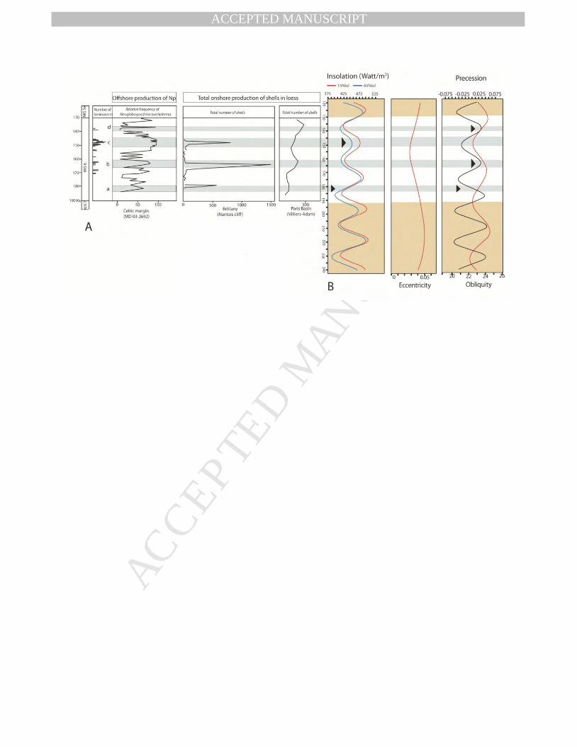
489
Correlations between the four Late Saalian “warming” episodes and the astronomical 490
parameters recognized by Milankovitch (1904) reveal a reasonable fit with most of the data. 491
However, for a better precision, the correlations were made with the variations of the 492
astronomical cycles calculated by Berger and Loutre (1991) showing their impact on the 493
boreal hemisphere insolation (July insolation at 15 and 65°N). The most recent “warming” 494
(Fig. 9: d) perfectly fits with a precession maximum and a minimum insolation. Warming c 495
can be correlated with an insolation maximum and a precession minimum (Fig. 9: c). 496
“Warming” b displays the same characteristics as warming d (Fig. 9: b). At last, warming a 497
does not fit with any major astronomic signal but corresponds with the mid-amplitude of a 498
positive insolation phase and with the mid-amplitude of a precession maximum (Fig. 9: a). 499
The addition of the effects of both signals being probably responsible for the first warming 500
episode observed during the Late Saalian climatic oscillations. These correlations are still 501
valid even if we take account of the small uncertainties attached to the upper and lower limits 502
of the “warming” episodes since the wavelengths of the insolation and of the precession 503
cycles are much larger than these uncertainties. 504
505
Fig. 9 here 506

MANUSCRIP
T
ACCEPTED
ACCEPTED MANUSCRIPT 507
6. Scientific results 508
509
Taken as a whole, sedimentary and biological markers permitted to recognize four phases of 510
low “warming” during MIS 6. These “warming” episodes were contemporaneous with four 511
positive variations of the sea level and with four variations of the astronomical cycles. 512
Indirect (“limon à doublets”) and direct (US-ESR) dating permitted to correlate two of these 513
episodes with the offshore stratigraphy characterized by clear evidences of contemporaneous 514
ice melting. This discovery was the opportunity to check the hypothesis of a possible 515
relationship between the irregular dwelling of Neanderthals in Brittany and the short climatic 516
improvements. 517
518
7. Discussion 519
520
This short discussion will be devoted to the possible relationship between the irregular 521
dwelling of Neanderthals in Brittany and the short MIS 6 climatic improvements. 522
523
7.1. Compilation of Neanderthals sites 524
525
Three main Neanderthal sites are now dated in Brittany; they are all located in Northern 526
Brittany close to Nantois cliff (Fig. 5). 527
- The Nantois site is a typical Palaeolithic site corresponding to a hunting rest area that 528
evidences well preserved cut up remnants. The archaeological layer (layer 35, Fig. 2A) 529
located 20 m below the Eemian paleosoil delivered few Mousterian artefacts and a bovid bone 530
(Monnier, 1986). Clear stratigraphic similarities with nearby sites where radiometric dating 531
has been carried out (Bahain et al., 2012), confirm the general chronostratigraphic scheme 532
previously suggested on the basis of field observations and major stratigraphic landmarks 533
(Monnier et al., 2011). Recent measurements show that layer 35 can be dated at 166 ± 8 ka 534
(Bahain et al., 2012). 535
-The 15 m thick stratigraphic sequence of Piégu site is made of 14 layers indexed from A to N 536
from the bottom to the top. It incorporates two beach deposits (units D and H) considered as 537
remnants of high sea levels during interglacial stages (Hallégouët et al., 1993). The sequence 538
includes also an interglacial palaeosoil (unit K) and several archaeological layers (units D, F, 539
G and J) with a Mousterian lithic industry and, for some of them, paleontological remains. 540

MANUSCRIP
T
ACCEPTED
ACCEPTED MANUSCRIPTLayer G is the main archaeological level; it corresponds to a “head” deposit (a periglacial 541
solifluxed frost shattered debris assemblage deposited during a glacial stage) (Danukalova et 542
al., 2015). This level delivered Mousterian flint flakes and a fossil fauna assemblage 543
indicating a wet temperate climate and a forested environment with local grasslands. Layer G 544
can be correlated with late MIS 7 or early MIS 6, with a quadratic mean age of 193 ± 6 ka 545
(Bahain et al., 2012). The archaeological assemblage witnesses the existence of a human 546
occupation on top of the cliff during an interglacial stage, in accordance with the 547
biochronological framework of Northern France (Auguste, 2009). The date proposed by 548
Monnier et al. (2011) for level J is confirmed by the dating results. Lastly, the Piégu’s marine 549
level H, with a quadratic mean age of 122 ± 23 ka can be attributed to Eemian (MIS 5e), by 550
US-ESR dates. 551
-The shelter-cave of Grainfollet is known for many years. It is made of two very close but 552
different units. The archaeological unit corresponds with a river shelf located at the foot of a 553
rocky cliff. On the shelf itself two remnants of fires associated with charcoals, burnt bones 554
and many artefacts have been sampled. It is not completly sure that some of the observed 555
Palaeolithic remnants have not been partly disturbed by solifluxion or by the tides (Monnier, 556
1982). The cliff is made of an alternation of loam, loess and stony levels. This area which 557
probably corresponded with a butchery was initially considered to be of Wûrm 1 age (Giot 558
and Bordes, 1955). Recent reappraisal of the cliff permitted paleo-densimetry measurement as 559
well as dating on bones and teeth (Laforge et al., 2018). Six ages were calculated, but one was 560
discarded because of the bad preservation of a tooth, they can be divided in two groups 561
ranging between 138 and 171 ka. 562
563
7.2. Improvement of the age error bars 564
565
Comparison between the different ages dating the MIS 6 occupation of Neanderthals in 566
Brittany evidences large error bars. These error bars are often larger than the duration of the 567
“warming” episodes. However, the ages which were finally retained for publication (Bahain 568
et al., 2012), almost always perfectly fit with the “warming” episodes. If we take account of 569
the error bars this excellent superimposition (based on 14 dated sites) is surprizing. It is why 570
the error bars have been recalculated (Ludwig, 2000), not only for individual ages but also for 571
the three groups of dates showing neighbouring ages (Fig. 10). Two solutions can be 572
considered, depending on the dating techniques. It seems that the 2 sigmas solution can be 573
selected for the sites studied in northern Brittany. 574
MANUSCRIP
T
ACCEPTED
ACCEPTED MANUSCRIPT 575
Fig. 10 here 576
577
7.3. Possible correlation between the “warming episodes” and the age of Neanderthal sites 578
579
The left column of Fig. 10 shows the superimposition of the “warming” episodes onto the age 580
of the Neanderthal sites with no error bars. The two columns on the right side show the same 581
superimposition after recalculation of the age error bars for the three groups of neighbouring 582
ages. The two sigmas error bars are still a little bit large but we believe that the almost perfect 583
superimposition of the “warming” episodes and of the mean quadratic age of the Neanderthal 584
sites must be also considered. It is mainly because the same superimposition of data repeats 585
14 times that we suggest that Neanderthal migrations were possibly controlled by the 586
successive climatic improvements recognized during MIS 6. 587
The dated “Les vallées” site located close to Nantois cliff (Fig. 5) was not considered during 588
these correlations. This site provided ages ranging between 138 and 182 ka (138 ± 22, 163 ± 589
23 and 182 ± 29 ka) on teeth (Bahain et al., 2012). Those ages which were supposed to date 590
the same stratigraphic unit correspond, after our correlations (Fig. 7), to three different 591
“warming” episodes questioning the correlations. However, a careful study of the technical 592
report concerning the excavation (Huet, 2010) arises various difficulties. The indurated sand 593
excavated for archaeology outcrops in the middle of a small plateau usually hidden under the 594
sand and the sea. The archaeological site (which investigated only 40 cm of sediment) 595
evidenced a poorly preserved horse mandible. No complete or intact bones or teeth were 596
found. All the fauna remnants were very fragmented and often soft, fragile and deeply 597
impregnated with salt. The spatial distribution of the pieces of bones evidenced the existence 598
of a clear solifluction casting. Furthermore, the archaeological site was established on a sand 599
dune which was probably more or less active at the time of its occupation by Neanderthals 600
and a general disturbance of the site was observed after this period of occupation. If we take 601
account of all these observations, we don’t know if the large dispersal of the published ages is 602
a reality, was associated with the bad condition of preservation of the teeth or if it resulted 603
from the mixture of faunal pieces of different origins. 604
605
8. General conclusions 606
607
-Study of the frequency of loess gastropods in Brittany, of animal and vegetal fossils markers 608

MANUSCRIP
T
ACCEPTED
ACCEPTED MANUSCRIPTof temperatures in Jersey and of the offshore laminae, permitted to recognize four short and 609
abrupt “warming” episodes during MIS 6. 610
-The contemporaneous variations of the sea level and the evolution of temperatures recorded 611
in EPICA and VOSTOK boreholes confirm the reality of the “warming” episodes found in 612
Brittany. 613
-Measurements of marine oxygen isotopes on foraminifera and on land snails currently 614
underway show that the “warming” episodes were not all characterised by the same 615
temperature. 616
-The “warming” episodes, which were responsible for an elevation of 30 to 40 metres of the 617
sea-level generated large ingressions of seawater in the mid-Channel valley. These 618
ingressions could have been at the origin of the development of oaks in Jersey, interrupting 619
during a short period, the cold continental tundra environment characterized by lemmings. 620
-Although the ESR/U dating of the archaeological sites, recalculated for the three main group 621
of ages, are still affected by error bars a little bit larger than the duration of the “warming” 622
episodes, we believe that their systematic association might suggest a relationship between 623
the climatic improvements and the migration of Neanderthals during MIS 6. 624
625
Acknowledgements 626
627
The authors would like to express there thanks to M.Y. Daire Director of the Laboratory of 628
ArcheoSciences (University of Rennes 1, France) for welcoming J.P. Lefort and G.A. 629
Danukalova in her Laboratory. We are also indebted to S.G. Kovalev Director of the 630
Geological Institute of the Ufimian Federal Research centre for the authorization he gave to 631
G. Danukalova to work on this and future programs related with Quaternary Researches in 632
Western Europe. This work was partly achieved thanks to the State Programs N-0252-2016-633
0006, 0246-2019-0118 and the Russian Government Program of Competitive Growth of 634
Kazan Federal University. The authors thank J.J Bahain, A. Shaw and A.Yakovlev for 635
scientific discussions, F. Bertin for various drawings and the reviewers of this paper for their 636
comments and improvement of the original English text. 637
638
References 639
640
Animal base, n.d. www.animalbase.uni-goettingen.de. 641

MANUSCRIP
T
ACCEPTED
ACCEPTED MANUSCRIPTAntoine, P., Bahain, J.J., Debenham, N., Frechen, M., Gauthier, A., Hatté, C., Limondin-642
Lozouet, N., Locht, J.L., Raymond, P., 2003. Nouvelles données sur le Pléistocène du nord du 643
Bassin parisien: les séquences loessiques de Villiers-Adam (Val d'Oise, France) (New data on 644
the Pleistocene of the north of the Paris basin: the loess-palaeosols sequences of Villiers-645
Adam (Val d'Oise. France). Quaternaire 14 (4), 219–235. 646
Astakhov, V., Shkatova, V., Zastrozhnov, A., Chuyko, M., 2016. Glaciomorphological Map 647
of the Russian Federation. Quaternary International 420, 4–14. 648
Auguste, P., 2009. Évolution des peuplements mammaliens en Europe du Nord- Ouest durant 649
le Pléistocène moyen et supérieur. Le cas de la France septentrionale. Quaternaire 20, 527–650
550. 651
Bahain, J.J., Falguères, C., Laurent, M., Shao, Q., Dolo, J.M., Garcia, T., Douville, E., Frank, 652
N., Monnier, J.L., Hallégouët, B., Laforge, M., Huet, B., Liouville, M., Serre, F., Gagnepain, 653
J., 2012. ESR and ESR/U-series dating study of several middle Palaeolithic sites of Pléneuf-654
Val-André (Brittany, France), Piégu, Les Vallées and Nantois. Quaternary Geochronology 10, 655
424–429. 656
Berruyer, O., 2013. Historique long et analyse du réchauffement climatique. Les Crises. 657
https://www.les-crises.fr/climat-6-rechauffement-global/ 658
Callow, P., Cornford, J.M., 1986. La Cotte de St Brelade 1962-1978. Excavation by C.B.M. 659
Mc Burney. Geobook. University Press. Cambridge. UK. 432 p. 660
Chaline, J., Brochet, G., 1986. The rodent fauna. In: Callow, P. and Cornford, J.M., La Cotte 661
de St Brelade 1962–1978. Excavation by C.B.M. Mc Burney. Geobook. University Press, 662
Cambridge, 139–143. 663
Danukalova, G., Lefort, J.P., Osipova, E., Monnier, J.L., 2013. Recent advances in the 664
stratigraphy of the Upper Pleistocene of Westernmost Europe: La Haute Ville and Bréhat 665
Cliffs (Northern Brittany, France). Quaternary International 284, 30–44. 666
Danukalova, G., Hallégouët, B., Lefort, J.P., Monnier, J.L., Osipova, E., 2015. Reconstruction 667
of the Middle-Late Pleistocene and Holocene palaeoenvironments of the Piégu Palaeolithic 668
site (Brittany, France) based on biostratigraphical data, Archéosciences, revue 669
d’Archéométrie 39, 7–30. 670
Danukalova, G., Monnier, J.L., Lefort, J.P., Osipova, E., Pustoc’h, F., Le Bannier, J.Ch., 671
2017. Sedimentological and malacological comparisons between the Upper Saalian and 672
Upper Weichselian loess superimposed in the Nantois cliff (France): Reconstruction of their 673
environments south of the British Ice Sheet. Archéosciences, revue d’Archéométrie 41 (2), 674
63–87. 675
MANUSCRIP
T
ACCEPTED
ACCEPTED MANUSCRIPTDerbyshire, E., Billard, A., Van Vliet-Lanoë, B., Cremashi, M., Lautridou, J.P., 1988. Loess 676
and paleoenvironment: Some results of a European joint programme of research. Journal of 677
Quaternary Sciences 3 (2), 147–170. 678
Eynaud, F., Zaragosi, S., Scourse, J., Mojtahid, M., Bourillet, J.F., Hall, I.R., Penaud, A., 679
Locascio, M., Reijonen, A., 2007. Deglacial laminated facies on the NW European 680
continental margin: the hydrographic significance of British-Irish Ice Sheet deglaciation and 681
Fleuve Manche paleoriver discharges, Geochemistry, Geophysics, Geosystems 8 Q06019, 682
doi:10.1029/2006GC001496. 683
Frenchen, M., 1999. Upper Pleistocene Loess stratigraphy in southern Germany. Quaternary 684
Geochronology 18, 243–269. 685
Giot, P.R., Bordes, F., 1955. L’abri sous roche paléolithique de Grainfollet à St Suliac (Ille et 686
Vilaine). L’Anthropologie 59 (3/4), 205–234. 687
Hallégouët, B., Monnier, J.L., Gagnepain, J., 1993. Le site Paléolithique moyen de Piégu (en 688
Pléneuf-Val-André), premiers résultats des fouilles. Mémoires de la Société d’Emulation des 689
Côtes-d’Armor 121, 3–17. 690
Huet, B. 2010. Le site paléolithique moyen des Vallées (Pléneuf-Val-André, Côtes-d’Armor). 691
Internal Report UMR 6566-CReAAH. University of Rennes. France. 62 p. 692
Kandiano, E.S., 2002. Dynamics of the Ocean Surface in the Polar and Subpolar North 693
Atlantic over the last 500 000 Years. Thesis University of Kiel, Germany. 90 p. 694
Kerney, M.P., Cameron, R.A.D., 1999. Guide des Escargots et limaces d’Europe. Delachaux 695
et Niestle S.A., Lausanne, 370 p. 696
Laforge, M., Bahain, J.J., Shao, Q., Falgueres, Ch., Laurent, M., Monnier, J.L., 2018. L’abri 697
sous roche de Grainfollet (St Suliac, Ille et Vilaine): chronostratigraphie et datation ESR-698
U/Th d’une occupation du Paléolithique moyen en context périglaciaire. Quaternaire (in 699
press). 700
Lautridou, J.-P., 1985. Le cycle périglaciaire pléistocène en Europe du Nord-Ouest et plus 701
particulièrement en Normandie. Centre Géormophologie (ed): University of Caen; 908 p. 702
Lefort, J.P., Danukalova, G., Eynaud, F., Monnier, J.L., Osipova, E., 2017. Mise en Evidence 703
de quatre courtes périodes de réchauffement pendant le Saalien Supérieur (190 à 130 ka) en 704
Bretagne. Bulletin de la Société Géologique et Minéralogique de Bretagne D15, 35–45. 705
Likharev, I.M., Rammelmeier, E.S., 1952. Land molluscs of the fauna of the USSR. Academy 706
of Sciences of USSR Press, Leningrad, Moscow, 512 p. (Determinative tables of the USSR 707
fauna. Proceedings of the Zoological Institute of the USSR Academy of Sciences 43 (in 708
Russian). 709

MANUSCRIP
T
ACCEPTED
ACCEPTED MANUSCRIPTLimondin-Lozouet, N., Gauthier, A., 2003. Biocenoses Pléistocènes des séquences loessiques 710
de Villiers-Adam (Val d’Oises, France): études malacologique et palynologique. Quaternaire 711
14, 237–252. 712
Lisiecki, L.E., Raymo, M.E.A., 2005. Pliocene-Pleistocene stack of 57 globally distributed 713
benthic δ18O records. Paleoceanography 20, PA1003, doi: 10.1029/2004PA001071. 714
Locht, J.L., Antoine, P., Bahain, J.J., Dwrila, G., Raymond, P., Limondin-Lozouet, N., 715
Gauthier, A., Debenham, N., Frechen, M., Rousseau, D.D., Hatté, Ch., Haesaerts, P., 716
Metsdagh, H., 2003. Le gisement paléolithique moyen et les séquencess pléistocènes de 717
Villiers-Adam (Val-d 'Oise): chronostratigraphie, environnement et implantations humaines. 718
Gallia préhistoire 45, 1–111. 719
Loyer, S., Monnier, J.L., van Vliet-Lanoë, B., Hallégouët, B., Mercier, N., 1995. La coupe de 720
Nantois (Baie de Saint-Brieuc, France): datations par thermoluminescence (TL) et données 721
paléoenvironnementales nouvelles pour le Pléistocène de Bretagne. Quaternaire 6 (1), 21–33. 722
Ložek, V., 1964. Quartärmollusken der Tschechoslowakei. Rozpravy Ustredniho ustuvu 723
geologického 31, 1–374. 724
Ludwig, K.R., 2000. Isoplot/Ex, A geochronological Toolkit for Microsoft Excel. Berkley 725
Geochronology Center. Special Publication N°1a. 726
Lyr, H., Garbe, V., 1995. Influence of root temperature on growth of Pinus sylvestris, Fagus 727
sylvatica, Tilia cordata and Quercus robur. Springer Verlag, Berlin 9 (4), 220–223. 728
McManus, J.F., Oppo, D.W., Keigwin, L.D., Cullen, J.L., Bond, G.C., 2002. Thermohaline 729
Circulation and Prolonged Interglacial Warmth in the North Atlantic. Quaternary Research 730
58, 17–21. 731
Martinson, D.G., Pisais, N.G., Hays, J.D., Imbrie, J., Moore, Jr.T.C., Shackleton, N.J., 1987. 732
Age dating and the orbital theory of the ice âges: Development of a high-resolution 0 to 733
300,000-year chronostratigraphy, Quaternary Research, 27, 1–29. 734
Mazeres, R., 1938. Contribution à l’étude des formations quaternaires des Côtes-du-Nord. 735
Bulletin de la Societé Géologique et Minéralogique de Bretagne, 13–16. 736
Mojtahid, M., Eynaud, F., Zaragosi, S., Scourse, J., Bourillet, J.F., Garlan, T., 2005. 737
Palaeoclimatology and palaeohydrography of the Glacial stages on Celtic and Armorican 738
margins over the last 360 000 years. Marine Geology 224, 57–82. 739
Monnier, J.L., 1973. Contribution à l’étude des dépôts quaternaires de la région de Saint-740
Brieuc. Travaux du Laboratoire d’Anthropologie – Préhistoire – Protohistoire – Quaternaire – 741
Armoricains. Thèse 3ème cycle, University of Rennes 1, France, 259 p. 742
MANUSCRIP
T
ACCEPTED
ACCEPTED MANUSCRIPTMonnier, J.L., 1982. Le Paléolithique inférieur et Moyen en Bretagne. Habitats et économie 743
des matières premières. Bulletin de l’Association française pour l’étude du Quaternaire 2–3, 744
93–104. 745
Monnier, J.L., 1986. Le gisement paléolithique moyen de Nantois, Pléneuf (Côtes du Nord). 746
Bulletin de la société Préhistorique française 83, 146–150. 747
Monnier, J.L., Bigot, B., 1987. Stratigraphie des dépôts pléistocènes du nord de la Bretagne 748
(France), les Formations de Port-Morvan et de la Haute-Ville. Bulletin de l’Association 749
française pour l’Etude du Quaternaire 32 (2), 93–103. 750
Monnier, J.L., Van Vliet-Lanoë, B., Hallégouët, B., 1997. Nantois. Saalian loesses, Eemian 751
pedocomplex, Weichselian succession. In: The Quaternary of Brittany. Guidebook. Travaux 752
du Laboratoire d’Anthropologie. Université de Rennes 1, p. 41–46. 753
Monnier, J.L., Huet, B., Laforge, M., 2011. Application of sedimentological analysis to 754
correlation of eroded layers under beaches with local and regional Pleistocene stratigraphy: a 755
contribution to geological dating of Palaeolithic sites, northern coast of Brittany, France. 756
Quaternary International 231, 78–94. 757
Mörner, N.A., 1996. Earth Rotation, Ocean Circulation and Paleoclimate: The North Atlanic–758
European case. In: Andrews, J.T., Austin, W.E.N., Bergsten, H., Jennings, A.E. (Eds.), Late 759
Quaternary Palaeoceanography of the North Atlantic Margins: an introduction. Geological 760
Society, London, Special Publications 111, 359–370. 761
Osipova, E., Danukalova, G., Markovic, S., 2013. Malacological characteristics of the Middle 762
to Upper Pleistocene transitional interval (MIS 7/5e) observed in the Batajnica locality 763
(Serbia). Quaternary International 292, 86–100. 764
Paillard, D., Labeyrie, L., Yiou, P., 1993. Macintosh program performs time-series analysis. 765
EOS Transactions. AGU 77, 379. 766
Penaud, A., Eynaud F., Turon, J.L., Zaragosi, S., Malaize, B., Toucanne, S., Bourillet, J.F., 767
2009. What forced the collapse of European ice sheets during the last two glacial periods (150 768
ka B.P. and 18 ka cal B.P.)? Palynological evidence. Palaeogeography, Palaeoclimatology, 769
Palaeoecology 281 (1–2), 66–78. 770
Puisségur, J.J., 1976. Mollusques continentaux quaternaires de Bourgogne. Significations 771
stratigraphiques et climatiques. Rapports avec d’autres faunes boréales de France. Mémoires 772
géologiques de l’Université de Dijon 3, France, 241 p. 773
Rodrigues, A., 2009. Le chêne pédonculé face aux changements climatiques. Agro Paris-774
Tech, ONF, 63 p. 775
Rousseau, D.D, Puissegur, J.J., Lautridou, J.P., 1990. Biogeography of the Pleniglacial 776
MANUSCRIP
T
ACCEPTED
ACCEPTED MANUSCRIPTmalacofaunas in Europe. Stratigraphic and climatic implications. In: Rousseau, D.D. (Ed.). 777
Methods and concepts in European stratigraphy. Palaeogeography. Palaeoclimatatology. 778
Palaeoecology 80, 7–23. 779
Seidenkrantz, M.-S., Bornmalm, L., Johnsen, S.J., Knudsen, K.L., Kuijpers, A., Lauritzen, S. 780
-E., Leroy, S.A.G., Mergeal, I., Schwegeer, C., Van Vliet-Lanoë, B., 1996. Two-step 781
deglaciation at the oxygen isotope stage 6/5e transition: the Zeifen-Kattegat climate 782
oscillation. Quaternary Science Reviews 15, 63–75. 783
Shackleton, N.J., 1987. Oxygen isotopes, ice volume and sea level. Quaternary Science 784
Reviews 6, 183–190. 785
Shileyko, A.A., 1984. Land molluscs of the Pupillina (Gastropoda, Pulmonata, Geophila). 786
Nauka Press, Leningrad, 399 p. (Fauna of the USSR. Mollusca, vol. 3, Issue 3) (in Russian). 787
Sümegi, P., Krolopp, E., 2002. Quartermalacological analyses for modeling of the Upper 788
Weichselian palaeoenvironmental changes in the Carpathian Basin. Quaternary International 789
91, 53–63. 790
Svendsen, J.I., Alexanderson, H., Astakhov, V.I., Demidov, I., Dowdeswell, J.A., Funder, S., 791
Gataullin, V., Henricksen, M., Hiort, C., Houmark-Nielsen, M., Hubberten, H.W., IngaIfsson, 792
O, Jakobsson, M., Kjaer, K. H., Larsen, E., Lokrantz, H., Lunkka, J. P., Lysav, A., Mangerud, 793
J., Matiouchkov, A., Murray, A., Maller, P., Niessen, F., Nikolskaya, O., Polyak, L., 794
Saarnisto, M., Siegert, C., Siegert, M.J., Spielhagen, R.F., Stein, R., 2004. Late Quaternary 795
ice sheet history of northern Eurasia. Quaternary Science Review 23, 1229–1271. 796
Toucanne, S., Zaragosi, S., Bourillet, J.F., Gibbard, P.L., Eynaud, F., Giraudeau, J., Turon, 797
J.L., Cremer, M., Cortijo, E., Martinez, P., Rossignol, L., 2009. A 1.2 Ma record of glaciation 798
and fluvial discharge from the West European Atlantic margin. Quaternary Science Reviews 799
28 (25-26), 2974–2981. 800
Toucanne, S., Zaragosi, S., Bourillet, J.F., Marieu, V., Cremer, M., Kageyama, M., Van Vliet-801
Lanoë, B., Eynaud, F., Turon, J.L., Cortijo, E., Gibbard, P.L., 2010. The first estimation of 802
Fleuve Manche palaeoriver discharge during the last deglaciation: Evidence for 803
Fennoscandian ice sheet meltwater flow in the English Channel ca 20-18 ka ago, Earth and 804
Planetary Science Letters 290 (3–4), 459–473. 805
Van Vliet-Lanoë, B., Guillocheau, F., 1995. Evolution de l’enregistrement pédosédimentaire 806
depuis 150 ka en Europe du Nord-ouest: biorhexistasie et bilans sédimentaires. Comptes 807
Rendus de l’Académie des Sciences, Paris, 320, IIa, 419–426. 808
Waelbroeck, C., Labeyrie, L., Michel, E., Duplessy, J.C., McManus, J.F., Lambeck, K., 809
Balbon, E., Labracheri, M., 2002. Sea-level and deep water temperature changes derived from 810

MANUSCRIP
T
ACCEPTED
ACCEPTED MANUSCRIPTbenthic foraminifera isotopic records. Quaternary Science Reviews 21, 295–305. 811
White, D., Preece, R., Shchetnikov, A., Parfitt, S., Dlussky, K., 2008. A Holocene molluscan 812
succession from floodplain sediments of the upper Lena River (Lake Baikal region), Siberia. 813
Quaternary Science Reviews 27, 962–987. 814
Zaragosi, S., Eynaud, F., Pujol, C., Auffret, G.A., Turon, J.-L., Garlan, T., 2001. Initiation of 815
the European deglaciation as recorded in the northwestern Bay of Biscay slope environments 816
(Meriadzek Terrace and Trevelyan Escarpment): a multi-proxy approach, Earth and Planetary 817
Science Letters 188(3-4), 493–507. 818
819
Captions 820
821
Figure 1. Location of the four sites where MIS 6 sections have been recognized west of 822
Europe. The sites are shown at the time of the maximum Late Saalian regression. LCSB: La 823
Cotte de Saint Brelade; MD 03-2692: Celtic Sea core; N: Nantois; Va: Villiers-Adam. Black 824
arrows: direction of the katabatic winds. Vertical ruling: British Ice Sheet. 825
826
Figure 2. Stratigraphy and frequency of the various terrestrial molluscs observed in loess of 827
the Nantois Formation (Saalian) of Nantois site. A: Nantois cliff section: stratigraphic 828
sequence according to Monnier (1973). Small Arabic numbers indicate the initial numbering 829
of the lithological units. B: Re-investigated loess interval (Upper Saalian). Numbers 830
correspond to the total land snail shells found in each sample. Symbol + indicates shells 831
detritus found in samples. Lithology: 1: soil (A horizon); 2: soil (B horizon); 3: colluvium 832
(angular rocky fragments) (=head); 4: loess or loess-like loam; 5: loamy sand; 6: sand; 7: 833
basement; 8: pebble; 9: loam; 10: published age; 11: incipient soils observed on the field. 834
Granulometry and CaCO3 data are shown. f: limit of decalcification; g: calcareous 835
concretions. LAD: “Limon à doublets”. The small stratigraphic differences observed between 836
sections A and B result from the erosion of the cliff during the last 40 years. For more details 837
see Danukalova et al., 2017. 838
839
Figure 3. A: Synthetic stratigraphic section of Villiers-Adam at Le Chamesson after Antoine 840
in (Locht et al., 2003). B: Section sampled for malacology, reinterpreted after the data 841
published by Limondin-Lozouet and Gauthier (2003). Numbering of the different layers by 842
Antoine (Locht et al., 2003). Simplified caption: 1: Sandy loam; 2: Sandy and clayish loam; 843
3: Stony and sandy layer; 4: Calcareous loess; 5: Sand; 6: Layered calcareous loess (niveo-844
MANUSCRIP
T
ACCEPTED
ACCEPTED MANUSCRIPTeolian sediment with small ice-drying cracks); 7: Layer number; 8: Stony and sandy layer 845
(heterometric stones association made of grindstones mixed in a brown and red clayish sand 846
matrix). The total number of each shell taxon is given for 10 kilos of sediment. Small letters 847
a1-2, b1-2 and c are malacozones and subzones according to Limondin-Lozouet and Gauthier 848
(2003) with authors’ additions. 849
850
Figure 4: Synthetic Upper Saalian section of La Cotte de Saint Brelade (Jersey Island) taken 851
directly from Callow and Cornford (1986). Note the place of the erosion levels and the 852
alternation between “cold” and “warm” fossil remnants 853
854
Figure 5. Extension of the Western English Channel ingressions during the different MIS 6 855
“warming” episodes. The archaeological sites of Northern Brittany and Jersey are shown. Sea 856
contours after P. Stephan, IUEM Brest (slightly modified). 857
858
Figure 6. Multiproxy data measured in core MD03-2692 sampled in Celtic Sea. XRF ratio of 859
Ca/ Fe; δ18O benthic record; No of laminae /cm; CLG c.: coarse lithic grain concentrations 860
and relative frequencies (%) of the polar species Neogloboquadrina pachyderma. Note that 861
the comparison with the SPECMAP δ18O benthic record (Martinson et al., 1987 at 862
ftp://ftp.ncdc.noaa.gov/pub/data/paleo/paleocean/specmap) and the LR04 δ 18O benthic stack 863
(Lisiecki and Raymo, 2005) underlines the robustness of the MD03-2692 age model 864
(Mojtahid et al., 2005). ZK: Zeifen-Kattegate episode. 865
866
Figure 7. Correlation between laminae and the different biological peaks recognized in the 867
Upper Saalian of Westernmost Europe; LAD: “Limon à doublets”; a, b, c, d: Correlation 868
stripes. Large numbers: Direct and indirect dating of the “warming episodes”. 869
870
Figure 8. Comparison between the four “warming” episodes that affected the Late Saalian 871
glacial stage and the contemporaneous variations of the sea level. a: Variations of the sea-872
level during the last 450 ka after Waelbroeck et al. (2002) (black curve) completed by the 873
Shackleton’s (1987) sea-level curve for the younger periods (in green), b: enlarged sketch for 874
the period of interest. δ18O values measured offshore (MD 03-2692) are also shown. c: 875
Correlation between laminae and the different biological peaks shown on figure 7; LAD: 876
“Limon à doublets”. d: Evolution of temperatures recorded in EPICA and VOSTOK 877
boreholes during MIS 6. Inset: photograph of a “limon à doublets” facies. 878
MANUSCRIP
T
ACCEPTED
ACCEPTED MANUSCRIPT 879
Figure 9. Comparison between the four “warming episodes” recognized during the Late 880
Saalian and the orbital parameters computed by Berger and Loutre (1991). A: Correlation 881
between biological peaks and laminae; B: Orbital parameters. 882
883
Figure 10. Comparison between MIS 6 “warming episodes” and Neanderthal dwellings. Left 884
column: ages of the various Neanderthals sites measured in Brittany during MIS 6 (Bahain et 885
al., 2012) superimposed onto the four “warming” episodes recognized onshore with no error 886
bar. Right columns: Calculation of error bars after the ISOPLOT software (Ludwig, 2000). 887
888
Table 1. Composition of the mollusc species recognized in the Nantois formation. 889
890
891
892

MANUSCRIP
T
ACCEPTED
ACCEPTED MANUSCRIPTTable 1.
Reg
istr
atio
n N
Lay
er N
Sam
ple
N
Sam
plin
g in
terv
al, m
Succ
inel
la o
blon
ga
(Dra
p arn
aud
, 18
01)
Pup
illa
mus
coru
m
(Lin
nae
us,
17
58)
Coc
hlic
opa
lubr
ica
(Mü
ller,
177
4)
Ver
tigo
cf.
alp
estr
is
Ald
er,
183
8
Val
loni
a pu
lche
lla
(Mü
ller,
177
4)
Hyd
rom
iidae
Lim
ax s
p.
Sh
ell d
etri
tus
To
tal (
qu
antit
y) D
eter
min
ed
terr
estr
ial m
ollu
sc
shel
ls
Gas
tro
po
da
(mar
ine)
Mal
aco
zon
e
3728 2
1 0-0,10 - 46 - - - - 2 1 48 - 1 3729 2 0,10-0,20 - - - - - - - 8 0 - 3730 3 0,20-0,30 - 1 - - - - - 168 1 16 3731
3 4 0,30-0,40 - - - - - - - 65 0 -
3732 5 0,40-0,50 - 1 - - - - - 130 1 3 3733
4
6 0,50-0,60 - 5 - - - - - 29 5 3 juv. 3734 7 0,60-0,70 - 1 - - - - - 46 1 1 3735 8 0,70-0,80 - 4 - - - - - 28 4 5 3736 9 0,80-0,90 - 5 - - - - - 29 5 2 3737 10 0,90-1,00 - 5 - - - - - + 5 - 3738 11 1,00-1,10 - 9 - - - - - 13 9 1 2 3739 12 1,10-1,20 - 53 1 - - - - 42 54 2 3740 13 1,20-1,30 - 148 - 1 - - 1 12 150 - 3741 14 1,30-1,40 - 2 - - - 1 juv. - 30 3 - 3742 15 1,40-1,50 - - - - - - - 228 0 - 3 3743
5
16 1,50-1,60 - - - - - - - 82 0 - 3744 17 1,60-1,70 - - - - - - - 102 0 - 3745 18 1,70-1,80 - 1 - - - - - 246 1 3 3746 19 1,80-1,90 - - - - - - - 39 0 - 3747 20 1,90-2,00 - 3 - - - - - 86 3 - 3748 21 2,00-2,10 - 1 - - - - - 39 1 - 3749 22 2,10-2,20 - 2 - - - - - 6 2 - 3750
6 23 2,20-2,30 - - - - - - - 10 0 -
3751 24 2,30-2,40 - - - - - - - 7 0 1 3752
7 25 2,40-2,50 - 3 - - - - - 53 3 1 4
3753 26 2,50-2,60 - 1 - - - 1 juv. - 5 2 - 3754
8 27 2,60-2,70 - 2 - - 1 - - 2 3 -
3755 28 2,70-2,80 - 7 - - - 2 juv. - 80 9 6 3756 29 2,80-2,90 - 55 - - 6 19 1 390 81 - 3757
9
30 2,90-3,00 1 5 - - - - - 48 6 - 5 31 3,00-3,10 - - - - - - - - - -
3758 32 3,10-3,20 - - - - - - - 2 0 - 33 3,20-3,30 - - - - - - - - - - 34 3,30-3,40 - - - - - - - - - - 35 3,40-3,50 - - - - - - - - - -
3759 36 3,50-3,60 - - - - - - - 2 0 - 37 3,60-3,70 - - - - - - - - - - 38 3,70-3,80 - - - - - - - - - -
10
39 3,80-3,90 - - - - - - - - - - 40 3,90-4,00 - - - - - - - - - - 41 4,00-4,10 - - - - - - - - - - 42 4,10-4,20 - - - - - - - - - - 43 4,20-4,30 - - - - - - - - - - 44 4,30-4,40 - - - - - - - - - - 45 4,40-4,50 - - - - - - - - - - 46 4,50-4,60 - - - - - - - - - - 47 4,60-4,70 - - - - - - - - - - 48 4,70-4,80 - - - - - - - - - - 49 4,80-4,90 - - - - - - - - - - Total 1 360 1 1 7 23 4 2038 397 44
Legend: + – shell fragments (size less than 1 mm); juv. – juvenile mollusc shell

MANUSCRIP
T
ACCEPTED
ACCEPTED MANUSCRIPT

MANUSCRIP
T
ACCEPTED
ACCEPTED MANUSCRIPT

MANUSCRIP
T
ACCEPTED
ACCEPTED MANUSCRIPT

MANUSCRIP
T
ACCEPTED
ACCEPTED MANUSCRIPT

MANUSCRIP
T
ACCEPTED
ACCEPTED MANUSCRIPT

MANUSCRIP
T
ACCEPTED
ACCEPTED MANUSCRIPT

MANUSCRIP
T
ACCEPTED
ACCEPTED MANUSCRIPT

MANUSCRIP
T
ACCEPTED
ACCEPTED MANUSCRIPT

MANUSCRIP
T
ACCEPTED
ACCEPTED MANUSCRIPT
MANUSCRIP
T
ACCEPTED
ACCEPTED MANUSCRIPT