on-the-spot checks according to art. 24, … · documents -ds-cdp-2015-08–final, ... list of...
TRANSCRIPT

DSCG/2014/32 - FINAL REV 2 Final
EUROPEAN COMMISSION DIRECTORATE-GENERAL FOR AGRICULTURE AND RURAL DEVELOPMENT Directorates D. Direct support and J. Audit of agricultural expenditure D.3 Implementation support, monitoring, IACS and LPIS
ON-THE-SPOT CHECKS ACCORDING TO ART. 24, 25, 26, 27, 30, 31, 34, 35, 36, 37, 38, 39, 40, 41 OF REGULATION (EU) NO 809/2014 AS AMENDED BY
REGULATION (EU) 2015/2333
GUIDANCE FOR ON-THE-SPOT CHECKS (OTSC) AND AREA MEASUREMENT1
CLAIM YEAR 2016
This guidance is referred to as the "OTSC guidance".
The purpose of this note is to give guidance to Member States (MS) on how the legal provisions in reference are best met, it is not to repeat what is in the legislation. In case part of the work related to on-the-spot checks is contracted out, it remains the responsibility of the MS that the work is carried out in line with the applicable legislation and to the standard required (cf. provisions in Regulation (EU) No 1306/2013 and its implementing act regarding IACS, i.e. Regulation (EU) No 809/2014 and Regulation (EU) 2015/2333). Detailed guidelines for the purpose of instructing the contractor are also the responsibility of the individual MS opting for sub-contracting.
This guidance document covers the content of OTSC for area-related aid schemes (direct payments) and the area measurement part of the OTSC of the area-related support measures (rural development measures in the scope of IACS). The aim of this document is to provide an implementation standard as regards what an OTSC is and what should be done so that the legal requirements are met. In addition, it provides recommendations on the sampling and the representativeness of the random OTSC. The technical specifications on “how” to perform the OTSC are now provided in separate guidance documents -DS-CDP-2015-08–FINAL, DS-CDP-2015-09–FINAL and DS/CDP/2016/03.
This guidance is either derived directly from the mentioned legal provisions or, whilst not expressing straight-forward legal obligations, constitutes recommendations by the Commission services to the Member States.
It should be emphasised that the considerations contained in this document are without prejudice to any further position taken by the Commission acting as a collegiate body, nor to any future judgement of the European Court of Justice, which alone is competent to hand down legally binding interpretations of the Union law.
1 This Guideline does not prejudge other specific guidelines for certain rural development measures or
cross-compliance obligations to be more restrictive. If this is the case the latter, more specific would take precedence.
Ref. Ares(2016)3152881 - 01/07/2016
DSCG/2014/32 - FINAL REV 2 Final
2
LIST OF ACRONYMS USED AND TERMINOLOGY FOR THE PURPOSE OF THIS DOCUMENT
ACRONYMS
AECM = Agri-Environment-Climate Measures;
AECC = Agri-Environment-Climate Commitments;
BPS/SAPS/SFS = Basic Payment Scheme/ Single Area Payment Scheme as referred to in Title III of Regulation (EU) No 1307/2013 and Small Farmers Scheme as referred to in Title IV of the same Regulation;
CAPI = Computer Assisted Photo Interpretation;
CART = Classification And Regression Tree;
CD = Crop diversification;
CwRS = Control with Remote Sensing;
CY = Claim Year;
EFA = Ecological focus areas as referred to in Article 46 of Regulation (EU) No 1307/2013 and its Delegated Regulation (EU) No 639/2014;
GAEC = good agricultural and environmental condition;
GNSS = Global Navigation Satellite System;
GSD = Ground Sampling Distance;
HR = High Resolution;
HHR = High High resolution; enhanced characteristics compared to HR;
LPIS = identification system for agricultural parcels as referred to in Article 70 of Regulation (EU) No 1306/2013;
MEA = Maximum Eligibility Area;
MS = Member States;
OTSC = on-the-spot checks;
PA = Paying Agency;
PG = Permanent Grassland as referred to in Art.4(1)(h) of Regulation (EU) No 1307/2013;
PG-ELP = Permanent Grassland under Established Local Practices as referred to in Art.4(1)(h) of Regulation (EU) No 1307/2013;
RA = Risk Analysis;

DSCG/2014/32 - FINAL REV 2 Final
3
RAnF = Ratio of “Area not Found”;
RF = Risk Factors;
RFV = Rapid Field Visits;
RMSE = Root Mean Square Error;
RP = Reference Parcel;
RS = Remote Sensing;
SFS = Small farmers scheme as referred to in Title V of Regulation (EU) No 1307/2013;
VCS = Voluntary coupled Support as referred to in Chapter 1 of title IV of Regulation (EU) No 1307/2013;
VHR = Very High Resolution;
VHR+ = VHRplus resolution; enhanced characteristics compared to VHR;
TERMINOLOGY
Area declared= the area as declared by the beneficiary in this aid application/payment claim (c.f. Article 72(1) of Regulation (EU) No 1306/2013);
Area determined= as defined in Article 2(23) of Regulation (EU) No 640/2014;
Beneficiary: as referred to in Article 2(1) of Regulation (EU) No 640/2014;
Control population = beneficiaries applying for an area-related aid scheme;
Control population for greening = beneficiaries required to observe the greening practices and who are not exempted or who are not participating in a certification scheme;
Control sample = sample of beneficiaries selected for an on-the-spot check;
Greening payment = the payment for agricultural practices beneficial for the climate and the environment as referred to in Chapter 3 of Title III of Regulation (EU) No 1307/2013;
Established (measured) area for EFA: Area of EFA resulting from direct field measurement or from delineation using ortho-imagery;
Random sample = group of beneficiaries selected randomly;
Risk-based sample = group of beneficiaries selected on the basis of a risk analysis.
DSCG/2014/32 - FINAL REV 2 Final
4
TABLE OF CONTENT
1. SELECTION OF THE CONTROL SAMPLE AND SELECTION OF CONTROL METHOD (ART. 30, 31, 34, 35 OF REGULATION (EU) NO 809/2014 AS AMENDED BY REGULATION (EU) 2015/2333) ............................. 7
1.1. General principles.............................................................................................. 7 1.2. Selection of appropriate control method ........................................................... 8 1.3. Random selection .............................................................................................. 8
1.3.1. The random sample concept ................................................................ 8 1.3.2. Types of random sampling .................................................................. 9
1.4. Risk analysis and annual assessment................................................................. 9 1.5. Control zones for CwRS.................................................................................. 10
1.5.1. Random selection .............................................................................. 10 1.5.2. Risk based selection .......................................................................... 11
2. ELEMENTS OF ON-THE-SPOT CHECKS/DETERMINATION OF AREAS (ART.37 AND ART.38 OF REGULATION (EU) NO 809/2014)............. 12
2.1. What/Why checking/controlling and measuring? ........................................... 12 2.2. Definition of the agricultural parcel ................................................................ 13
2.2.1. General principles.............................................................................. 13 2.2.2. Specificities of the Greening payment .............................................. 14 2.2.3. Minimum parcel size ......................................................................... 14
2.3. Definition of the area to be determined/measured for eligibility to BPS/SAPS/SFS................................................................................................ 15
2.4. On-the-Spot checks general principles............................................................ 15 2.4.1. General considerations ...................................................................... 15 2.4.2. Sample of parcels to be determined/measured .................................. 16 2.4.3. Location of the claimed parcel for classical on the spot checks........ 18 2.4.4. Checking eligibility conditions.......................................................... 19 2.4.5. Determination of the parcel area, use of the technical
tolerance ............................................................................................ 26 2.4.6. Determination of the crop group area................................................ 27 2.4.7. Quality control................................................................................... 27 2.4.8. Feedback of on-the-spot check results into the LPIS and the
EFA-layer .......................................................................................... 28
3. CLASSICAL ON-THE-SPOT CHECKS ................................................................. 28
3.1. Preparation, timing, and advance warning ...................................................... 28 3.2. When to determine eligible area through a measurement ............................... 29
3.2.1. Introduction ....................................................................................... 29 3.2.2. Determination of area through deduction of ineligible
features/areas ..................................................................................... 30 3.2.3. Direct measurement........................................................................... 32 3.2.4. Combination of partial field measurements and on screen
measurement...................................................................................... 33
4. ART.40 ON-THE-SPOT CHECKS USING REMOTE SENSING (CWRS)........... 33

DSCG/2014/32 - FINAL REV 2 Final
5
4.1. Number of control zones ................................................................................. 33 4.2. Principles of CwRS and possible strategies .................................................... 34 4.3. Parcel area check ............................................................................................. 35 4.4. Determination of land use ............................................................................... 35 4.5. Rapid Field Visits ............................................................................................ 36
ANNEX I........................................................................................................................... 37
1. THE CONTROL RATES FOR AREA-RELATED AID SCHEMES (ART.30, 31, 35 AND 36 OF REGULATION (EU) NO 809/2014) ........................ 37
1.1. What are the control rates for area-related aid schemes other than the greening payment?........................................................................................... 37
1.2. What are the control rates for the greening payment?..................................... 37 1.3. Is it required to increase or possible to reduce these control rates? ................ 38
2. THE SAMPLE SELECTION (ART.34 OF REGULATION (EU) NO 809/2014 AS AMENDED BY ART. 1 (11) OF REGULATION (EU) 2015/2333)................................................................................................................. 38
2.1. For which schemes is there a risk analysis part in the sample?....................... 38 2.2. What does Art.34(4) of Regulation (EU) No 809/2014 mean?....................... 39 2.3. What are the general principles of the sample selection?................................ 39 2.4. What does Art. 34(2) 2nd sub paragraph of Regulation (EU) No
809/2014 as amended by Art. 1 (11)(a)(ii) of Regulation (EU) 2015/2333 mean?............................................................................................. 41
2.5. What is the BPS/SAPS control sample composed of? .................................... 41 2.6. What is the greening control sample composed of? ........................................ 42 2.7. Are the applicants chosen by the risk analysis for greening measures
and for the exempted from the greening obligations considered as randomly selected for BPS/SAPS?.................................................................. 42
2.8. What happens if the number of beneficiaries subject to greening in the random BPS/SAPS sample is higher than necessary for the random greening selection (1-1.25%)?......................................................................... 42
2.9. How to split the greening population into exempted and non-exempted populations (Art.31(1) of Regulation (EU) No 809/2014)? ............................ 43
2.10. What does the '3% sample' cover? .................................................................. 43 2.11. What is the exempted from greening control sample composed of?............... 44 2.12. What happens in case a beneficiary declared as exempted from the
greening requirements is found as not exempted? .......................................... 44 2.13. What are the control samples for redistributive payment, payment for
ANC, YFS, area-related VCS incl. hemp, payment for cotton composed of?................................................................................................... 45
2.14. What is the control sample for SFS composed of?.......................................... 45
ANNEX II ......................................................................................................................... 48
GUIDANCE FOR THE REPRESENTATIVENESS S OF THE RANDOM ON-THE-SPOT CHECKS (OTSC) FOR AREA-BASED MEASURES ........................ 48
1. LEGAL FRAMEWORK........................................................................................... 48
1.1. General principles............................................................................................ 48

DSCG/2014/32 - FINAL REV 2 Final
6
1.1.1. Representativeness ............................................................................ 48 1.1.2. Randomness....................................................................................... 48
1.2. Representative vs Random concept................................................................. 49
2. SELECTION METHOD ........................................................................................... 49
3. DESIGNING THE SAMPLING ............................................................................... 49
3.1. Define the objectives ....................................................................................... 49 3.2. Define deviations (errors)................................................................................ 49 3.3. Define the population ...................................................................................... 50
3.3.1. Check the completeness of the population ........................................ 50 3.3.2. Define the period to be covered......................................................... 50 3.3.3. Define the sampling unit ................................................................... 50 3.3.4. Homogeneity of the population ......................................................... 50
3.4. Determine the sampling selection method ...................................................... 51 3.5. Determine the sample size............................................................................... 51 3.6. Perform the sample.......................................................................................... 51 3.7. Evaluating the sampling results....................................................................... 52 3.8. Documenting the sampling procedure............................................................. 52

DSCG/2014/32 - FINAL REV 2 Final
7
1. SELECTION OF THE CONTROL SAMPLE AND SELECTION OF CONTROL METHOD (ART. 30, 31, 34, 35 OF REGULATION (EU) NO 809/2014 AS AMENDED BY REGULATION (EU) 2015/2333)
1.1. General principles
Art.34 of Regulation (EU) No 809/2014 sets out the methodology for the selection of the control sample of Articles 30 (area-related aid schemes other than the greening payment), 31 (the greening payment). Regulation (EU) No 809/2014 introduces changes in the sampling methodology as from CY2015. Further changes were introduced for CY2016 by Commission Implementing Regulation (EU) No 2015/2333 amending Regulation (EU) No 809/2014. In the context of area-related aid schemes (direct payments), random sampling is compulsory for BPS/SAPS, greening payments, the beneficiaries exempted from greening and the small farmer schemes (Article 34(2)(a), (b), (ba), (f), (h), (ha) and (i)), as well as for the other schemes listed in Article 30 of Regulation (EU) No 809/2014. "Risk analysis" (RA) is compulsory only for the samples for greening payment, including the beneficiaries exempted from the greening (Article 34(2)(c), (h) and (i)), as well as for the multiple visits foreseen under Article 26(4) and the additional 5% sample when the EFA layer is not complete- Article 31(3).
The provisions of Article 34(2)(d) and (e) allow for combining the visits on the lowest number of farms and their implementation should thus be as wide as possible even if letters (d) and (e) may allow the competent authority to decide for other modalities of selection of the referred samples.
Member States could also decide to use sampling done under Article 34(2)(a) to select the random beneficiaries to be checked under Art. 32 and Art. 33 and vice versa, in view of reducing the overall number of farms visited for on the spot checks (further elaborated in point 2.3 of Annex I). As regards the risk-based samples and their possible integration for Pillar I and Pillar II IACS measures, normally, the risk factors should by definition be specific to the schemes concerned. It is ultimately for the Member State's competent authority to establish the risk analysis in such a way that it meets the characteristics referred to in recital (33) as well as the requirements set out in Article 34(5) of Regulation (EU) No809/2014. However, in no case should the integration of the random samples and/or the risk-based samples jeopardize the effectiveness of the risk analysis to be done under Art. 34(3) of Regulation (EU) No 809/2014 for RD measures in the scope of IACS.
It is expected that in case of increase of the control rate as referred to in Art. 35 of Regulation (EU) No 809/2014, the major part of the selection is done by risk analysis. In any case, the random part in the additional sample should not exceed 25% (Art. 34(4)).
Regarding the additional controls to be done in case the EFA-layer is not in place, in the second sub-paragraph of Art.31(3) of Regulation (EU) No 809/2014:

DSCG/2014/32 - FINAL REV 2 Final
8
– by 'all EFA declared are identified' is meant that a systematic plausibility check of the existence of the declared EFAs is made by the MS, based on the most recent imagery available if necessary supplemented by a RFV; 2
– the recording of the stable EFA has to be done along the lines set-up in the EFA layer guidance for claim year 2015 onwards (DSCG/2014/31 FINAL) after the verification of their existence (implying possibly RFV).
1.2. Selection of appropriate control method
Art.24 of Regulation (EU) No 809/2014 stipulates that "Administrative checks and on-the-spot checks provided for in this Regulation shall be made in such a way as to ensure effective verification of (a) the correctness and completeness of the information provided in the aid application, application for support, payment claim or other declaration; (b) compliance with all eligibility criteria, commitments and other obligations for the aid scheme and/or support measure concerned, the terms under which aid and/or support or exemption from obligations are granted; (c) the requirements and standards relevant for cross-compliance […]"
The above requires Paying Agencies (PA) to come up with a control strategy that fulfils the legal requirements in an effective and yet efficient way. That is why, PA are advised to reflect in their control strategy the geophysical particularities of the country, stratify the control population accordingly and select the most appropriate control method (a classical on-the-spot check or a control with remote sensing (CwRS)) for effective verification of every particular claim selected. Please also refer to Annex II for further guidance on sampling.
As a general principle, it is expected that the level of non-compliance found in the random or risk sample should be similar whatever the control method. If this is not the case, the MS should analyse its individual situation and take appropriate action. In that context, quality controls (see chapter 2.4.7) are essential.
1.3. Random selection
1.3.1. The random sample concept
The random sample permits an estimate of the background level of anomalies in the system. It supports decisions enacting the mechanism for increasing the control rate (in accordance with Art.35 of Regulation (EU) No 809/2014) and also permits an assessment of the effectiveness of the criteria being applied for risk analysis.
2 Those plausibility checks have to be done without prejudice of the normal administrative controls
including cross-checks that have to be performed on 100% of the applications.

DSCG/2014/32 - FINAL REV 2 Final
9
1.3.2. Types of random sampling
The main statistical criterion of random sampling is that all dossiers should have an equal probability of selection. In this regard, two approaches are considered most appropriate:
• Simple random sampling from the full population: selection from the full population of dossiers through the generation of a random key. However, this approach may require waiting until the full population is known before the sample can be determined, which is not always recommendable in particular when control should occur within a short period (e.g. crop diversification).
• Systematic sampling: after a first dossier selected at random among the first 100 dossiers, for example each 100th dossier delivered at a collection centre or in the computer system. Whilst this approach has the advantage of producing dossiers for on-the-spot check immediately (without waiting for the determination of the full population), care must be taken to avoid creation of bias in the input order of dossiers.
These methods can be applied in the following ways:
• Simple random sampling: the population is considered homogeneous (unique stratum). There is one random sample taken from the population.
• Stratified random sampling: the population is considered heterogeneous with the presence of certain strata (defined by criteria). The random sample is divided into strata, the dossiers being randomly selected inside each stratum. The size of each part of the sample is proportional to the corresponding stratum size. a certain number of dossiers are randomly selected inside each stratum.
• Cluster sampling: Often geographically clustered (but could be clustered in another dimension), with random selection within the cluster e.g. a CwRS zone.
As general rule, any procedure leading to the exclusion (i.e. impossibility of selection) of some dossiers should be avoided as it would evidently prevent the equal probability of selection. This problem may arise when applying cluster sampling. For instance, excluding parts of the territory because there is no dossier is relevant. On the other hand, excluding parts of the territory for sake of efficiency because the dossier’s density is low would introduce a bias in the random sampling.
1.4. Risk analysis and annual assessment
According to Art.34(5) of Regulation (EU) No 809/2014, MS are responsible for the definition of the risk criteria to be used for the risk analysis. It is the
DSCG/2014/32 - FINAL REV 2 Final
10
MS' responsibility to assess the effectiveness of the risk analysis on an annual basis and to update it by establishing the relevance of each risk factor. A first step in this annual evaluation is the comparison of the results of the risk based and randomly selected sample. In addition, (causes for) material differences between results from one year to another need to be analysed.
The ratio of “area not found” (RAnF) i.e. the total area not determined in the relevant crop group over the total declared area for the same crop group computed on the whole risk-based sample, is the key factor in analysing the risk to the fund.
For this, MS can rely on a CART model (i.e. Classification and Regression Tree), which is explained in detail in section 3.2 B of document DS-CDP-2016-03. .
1.5. Control zones for CwRS
Contrary to classical checks which can be geographically dispersed, in the case of CwRS, the areas where imagery is to be acquired need to be established. This clustering of checks is called a "control zone", and is a geographical area defined on the basis of GIS analysis.
Following the reform, the eligibility conditions for farmers are very much linked to types of farming and thus of natural and agronomical conditions. It is therefore essential to ensure the representativeness of all those conditions/ requirements in the choice of the RS zones (see in particular Art. 34(2) last sub-paragraph of Regulation (EU) No 809/2014). This is particularly true as RA is mainly foreseen to be used for the greening samples. The Commission services hence recommend opting for a higher number of zones of small size.
1.5.1. Random selection
For the selection of the random sample, the following strategies may be applied:
• Select applications randomly from the full list of applications. Most likely this sample will be scattered over the MS territory and will have to be checked by classical inspection for most of the claims. However applications falling in a control zone may be checked with RS (and will be counted as part of the random sample even if the zone was selected on the basis of risk analysis).
• Alternatively, a zone is randomly selected, and inside this zone applications are selected systematically (i.e. all applications falling in the zone are checked) or randomly to constitute (part of or) the total random sample. It is not advised to have the random sample concentrated in one or 2 zones (except for smaller MS); a minimum number of 5 random zones should be defined for the representativeness of the sample.

DSCG/2014/32 - FINAL REV 2 Final
11
A combination of the previous two strategies is also possible, for instance in countries where two distinct strata coexist: one stratum of intensive agriculture inside which random zones could be selected for RS checks and the other of more extensive agriculture (i.e. pastures mingled with non-agricultural features) in which classical inspections would be used to check the scattered (random) applications.
1.5.2. Risk based selection
For the selection of the risk based sample, again two strategies are possible:
• Select the control zones at random and perform RA inside the zones (provided there are enough applications in the zones to allow an efficient RA);
• Select control zones using RA and then select applications inside these zones either in a systematic way i.e. all applications or using RA among the applications falling inside the zones, in case the number of applications inside the zones is larger than the targeted number.
Notwithstanding exceptions, selecting all applications inside a zone selected by RA is likely to result in an overall weaker RA than selecting applications individually out of the whole population of applicants. On the other hand, controlling all applications in a given area may enable a more complete check of adjacent applications (for example, when sharing reference parcels). Note that this would be essential for certain types of implementation of the greening requirements (e.g. collective, regional approaches) and for common land.
Selecting control zones on the basis of RA does not necessarily mean selecting all zones in the high risk stratum only (which may be the same every year). Zones could also be selected in medium and low risk strata, but with lower sampling rates than in the high risk stratum (see the example at the end of chapter 3). This strategy presents the advantage of distributing the control pressure in every stratum, which may later be useful at the time of assessing the RA.

DSCG/2014/32 - FINAL REV 2 Final
12
2. ELEMENTS OF ON-THE-SPOT CHECKS/DETERMINATION OF AREAS (ART.37 AND ART.38 OF REGULATION (EU) NO 809/2014)
2.1. What/Why checking/controlling and measuring?
The purpose of on-the-spot checks is to check the conditions under which aid is granted on a sample of applications. In practice, for each parcel declared in the single application, this means checking at least:
• The eligibility of the declared area of the agricultural parcels in accordance with the Regulation (EU) No 1307/2013, in particular Art. 32 paragraphs (2) to (6); this should include the verification of the minimum maintenance/minimum activity in relation to Art.4(1)(c)(ii) and (iii) of Regulation (EU) No 1307/2013; Note that the verification of minimum activity referred to in Art. 4(1)(c)(iii) is also valid, where appropriate, for the verification of the active farmer clause;
• The compliance with the minimum size of the agricultural parcel where necessary as referred to in Art.72(1) last subparagraph of the Regulation (EU) No 1306/2013;
• The declared land use to the extent requested by the regulation (permanent grassland, area-related VCS, crop diversification, etc.), including the agricultural area types declared (i.e. permanent grassland, arable land, permanent crop);
• The number and/or position of trees and landscape features or the classification in pro rata categories where necessary (e.g. Art. 9 and 10 of Regulation (EU) No 640/2014, title IV of Regulation (EU) No 1307/2013);
• Other conditions MS have set as to ensure that parcels declared are indeed the parcels the beneficiary is entitled to claim aid on, as well as the declaration of all areas.
• All obligations related to greening practices or equivalent practices to be respected by the beneficiary;
• Where relevant, the compliance with the thresholds referred to in Articles 44 and 46 of Regulation (EU) No 1307/2013 for exemption from the greening;
• Where relevant, the specificities for regional or collective implementation spelled out in Art.37(3) of Regulation (EU) No 809/2014.
Contracts, seed certificates and other conditions (e.g. for controlling the "active farmer" eligibility conditions, VCS, etc.) that need to be met but cannot be checked on the imagery or in the field will require that specific control provisions are set up by the MS authorities. Those controls would have to be done whatever the control method for the other eligibility conditions.

DSCG/2014/32 - FINAL REV 2 Final
13
2.2. Definition of the agricultural parcel
Art.67 of Regulation (EU) No 1306/2013 defines the agricultural parcel in the following way: “agricultural parcel” means a continuous area of land, declared by one farmer, which does not cover more than one single crop group; however, where a separate declaration of the use of an area within a crop group is required in the context of Regulation (EU) No 1307/2013, that specific use shall if necessary further limit the agricultural parcel; Member States may lay down additional criteria for further delimitation of an agricultural parcel;
When a Member State opts for further limitation of the agricultural parcel, the same definition should be applied systematically.
2.2.1. General principles
While taking account of the definition of crop group of Art.17 of Regulation (EU) No 640/2014, Member States have the possibility to choose the most appropriate "level" of the agricultural parcel for their context: it could for instance be the "BPS/SAPS crop group" parcel as shown in the example below which should be further delimited in case of area-related VCS.
It could also be the agricultural area type of parcels (arable land, permanent grassland/ permanent pasture, permanent crop) as shown in the example below.
Where the Member State defines the "single crop" parcel as the agricultural parcel, the four fields in the example below would correspond to four agricultural parcels (one of these, being also claimed for VCS).
Wheat Protein crop
Wheat Perm.
grassland
Wheat Protein crop Wheat Perm.
grassland
Protein crop
1 "BPS/SAPS" parcel
4 "single crop" parcels
1 agricultural parcel
Wheat Wheat Perm. grassland
1 "BPS/SAPS" parcel
+ 1 "VCS" parcel
2 agricultural parcels
2 "agricultural area type"
parcels
Arable land
Perm. grassland
DSCG/2014/32 - FINAL REV 2 Final
14
Where the crop or cover type is not explicitly required by the regulation as an eligibility criteria for the payment, declaring "crop group" parcels instead of "single crop" parcels may simplify the farmer's declaration and the control, in particular when a "crop group" parcel is composed of one or more fully declared reference parcels.
However, in case of a VCS based on a certain crop, the agricultural parcel shall be set at the level of this single crop and the minimum parcel size defined by MS applies.
2.2.2. Specificities of the Greening payment
In the context of crop diversification, the areas of each single crop shall be declared by the farmers in view of calculating the shares of each crop but they do not necessarily require a further delimitation of the "BPS/SAPS parcel" into several "single crop" parcels. The OTSC will determine the area of each crop based on the cropped areas' limits that are visible in the field (the crop itself or the crop residues) or on the imagery used in CwRS (see chapter 2.4.4.3).
In the context of the EFA, each area declared as EFA should be clearly indicated by the farmer in its single application and identified unambiguously. However, (eligible) EFAs do not require a further delimitation of the "BPS/SAPS parcel".
In the context of greening/protection of permanent grassland, each area of permanent grassland should be declared separately by the farmer in its single application and identified unambiguously.
2.2.3. Minimum parcel size
The last sub-paragraph of Art. 72(1) of Regulation (EU) No 1306/2013 foresees that MS define a minimum size (below or equal to 0.3ha) of agricultural parcels in respect of which an application may be made.
Commission services interpretation of this provision is the following:
• This minimum size applies to agricultural parcels claimed for payment, i.e. at the level of the "BPS/SAPS parcel" or where it applies at the level of the "VCS parcel". Hence, this minimum size should not apply at the level of the single crop or the individual EFAs declared in view of checking the fulfilment of the greening practices.
• Those agricultural parcels below the minimum size should count in the calculation of the different shares of greening requirements (exemption thresholds, share of crops for crop diversification, share of EFA to be fulfilled, etc.).

DSCG/2014/32 - FINAL REV 2 Final
15
2.3. Definition of the area to be determined/measured for eligibility to BPS/SAPS/SFS
The total eligible area (see Art. 32 paragraphs (2) to (6) of Regulation (EU) No 1307/2013) of the agricultural parcel, in accordance with Art.9 and 10 of Regulation (EU) No 640/2014, should be determined/measured (see Art.38(5) of Regulation (EU) No 809/2014 and 'LPIS guidelines' - document DSCG/2014/33). In particular, man-made constructions, areas not taken up by agricultural activities and/or ineligible landscape features and trees should as a general principle already be deducted from the MEA of the RPs in the LPIS. This has to be checked on-the-spot.
The assessment of the maximum tree density and other related provisions under Art. 9(3) should be checked during OTSC. The conditions of application of the pro-rata on permanent grassland with scattered ineligible features and the categories of the pro-rata in which each concerned RP falls should also be checked during OTSC (i.e. the correctness of the MEA registered in the LPIS for those RPs).
2.4. On-the-Spot checks general principles
2.4.1. General considerations
Two control methods are possible for on-the-spot checks: the classical on-the-spot checks which are performed in the field, and the control with remote sensing (CwRS), which is performed by photo-interpretation of satellite or aerial ortho-imagery and where the photo-interpretation does not allow concluding satisfactorily for all conditions accompanied by Rapid Field Visits (RFV). As far as the verification of eligibility criteria is concerned, Articles 24(1)(b) and 38(1) of Regulation (EU) No 809/2014 require that all agricultural parcels shall be subject to eligibility checks during an OTSC.
Every on-the-spot check shall be the subject of a control report in accordance with Art.41 of Regulation (EU) No 809/2014 which makes it possible to review the details of the checks carried out and to draw conclusions on the compliance with the eligibility criteria, commitments and other obligations. The inspector / photo-interpreter should have received sufficient instructions and training (e.g. knowing accuracy of tools, conditions of use of tools, limitations of use of tools, etc.), and be largely able to undertake the work autonomously. S/he should have no conflicts of interest. In order to provide a result to the appropriate precision and to ensure effective verification, s(he) must have access to appropriate claim data (including map information) and measuring equipment.
It is recommended that the principles for eligibility check, parcel borders definition, treatment of landscape features and trees, etc. are commonly shared between farmers, photo-interpreters, field inspectors and LPIS custodians. The creation of OTSC guides (paper, online) with examples (field pictures, images, etc) on how to deal with these elements, which are made available to farmers and controllers, would facilitate a common understanding.

DSCG/2014/32 - FINAL REV 2 Final
16
Due to the sampling method for area-related aid schemes provided under Art.34 of Regulation (EU) No 809/2014, most of the farms in the different OTSC samples (of Art. 30 and 31) will be controlled for BPS/SAPS. Note that under the amendment in Art. 34 introduced by Regulation (EU) 2015/2333, there is a possibility to start the cascade from Pillar II measures covered by IACS under Art. 32. Please refer to 2.3 of Annex I of the present document.
2.4.2. Sample of parcels to be determined/measured
As a principle, on-the-spot checks shall cover all the agricultural parcels for which an application for aid has been submitted and the check of their eligibility conditions and where appropriate uses, in relation to each scheme should be carried out (see Art.38(1) of Regulation (EU) No 809/2014 and section "checking eligibility conditions" below).
In contrast to the eligibility check on 100% of the claimed agricultural parcels, Art. 38(1) gives the possibility to limit the actual determination/ measurement of the areas as part of an on-the-spot check to a randomly selected sample of at least 50% of these agricultural parcels (hereinafter referred to as the "50% agricultural parcels sample"). Parcels, once selected, should not be dropped from the set to be checked. When this sample check reveals any non-compliance, all agricultural parcels should be measured, or conclusions from the measured sample should be extrapolated.
2.4.2.1. Sample of parcels to be determined/measured when RS is used
Where use is made of RS, it should be ensured that the parcels outside the RS zone have an equal chance of being selected when the derogation of limiting the actual determination/measurement of the area to only a percentage of all parcels is applied (Art 38(1)). This is even valid if all parcels inside the zone represent more than 50% of agricultural parcels. Otherwise there is a risk of introducing a bias in the random sample.
In a first step, a scan of all agricultural parcels should be performed using most recent available imagery. This has as objective to detect any blatant anomaly that requires follow-up during the classical or RS on-the-spot check. In a second step, the actual area determination can be limited to 50% of the parcels. The above consideration may have some implications when VCS, maintenance/minimum activity, some aspects of greening are controlled with RS (eligibility criteria which are not verifiable through an LPIS check) and particularly in respect of the possible extrapolation of the results. When a MS tries to maximize the number of beneficiaries to be controlled through RS for a particular scheme, examples of several approaches for CwRS for the random samples are provided below:
1. For the randomly selected RS zones- within the zone, beneficiaries are selected randomly and their parcels are

DSCG/2014/32 - FINAL REV 2 Final
17
selected randomly. If this approach is applied, it means that the parcels falling out of the RS zone should be visited in the field since all parcels should undergo an eligibility check. In addition, if the parcels selected for measurement are selected randomly, there is a possibility that parcels outside the zone are selected and those should be measured in the field. The measurement results are to be extrapolated to the non-measured parcels or otherwise, all agricultural parcels should be measured.
2. For the randomly selected RS zones- within the zone, only beneficiaries with more than 50%3 of their parcels that are within the zone are selected. For the measurement derogation, all parcels within the zone are selected. If this approach is applied, it means that the parcels falling out of the RS zone for the selected beneficiaries should be visited in the field since all parcels should undergo an eligibility check (for example checking the presence of the crop for VCS). As regards the measurement, it could be limited to the parcels within the RS zone since the criteria for selecting beneficiaries was with more than 50% of the parcels to be within the zone and since the zone was selected randomly. The measurement results are to be extrapolated to the non-measured parcels or otherwise, all agricultural parcels should be measured.
3. For the randomly selected RS zones.- within the zone, only beneficiaries with 100% of their parcels within the zone are selected. For the actual measurement, either all parcels are measured or a random sample is selected and the measurement results are extrapolated to the non-measured parcels. If the results are not extrapolated, all agricultural parcels need to be measured. In this case, all eligibility criteria must be verifiable through the RS. A RFV may be required if the result of the CwRS is not conclusive. However, MS should be aware that this could lead to having increased number of RS zones.
4. For the risk-based selected zones, as regards the 50% randomly selected parcels the same principles apply. Please note that consequently the scenario as described in point 2 is not appropriate for risk-based zones.
In accordance with the last paragraph of Art. 38(1), this sampling does not apply to EFAs, hence it is expected that each area declared as EFAs should be determined.
3 The same principle will apply if the MS sets any percentage above 50% of the parcels (i.e. 80% of the
beneficiary's parcels to be within the RS zone). In case the selected beneficiaries under this criterion significantly exceed the minimum number of beneficiaries that need to be controlled, a random sample of those beneficiaries could be selected. The same is also applicable in case the selection is done pursuant to point 3.

DSCG/2014/32 - FINAL REV 2 Final
18
As regard crop diversification, where the MS has not chosen the "single crop parcel" as the agricultural parcel, the OTSC should ensure a sufficient level of determination/measurement of the areas of each single crop declared (including land laying fallow and grasses or other herbaceous forage). This could be done e.g.:
- by systematically determining/measuring, within the "50% agricultural parcels sample", the "single crop areas" declared and where necessary, determine/measure additional "single crop areas" until the crop diversification requirement is verified as fulfilled (i.e. in case of at least 2 crops required, verification of "at least 25% of the arable land covered by second crop and others" and in case of at least 3 crops required, verification of "at least 25% of the arable land covered by second crops and others" and "at least 5% of the arable land covered by third crops and others");
- by applying the same rule of sampling of Art. 38(1) at the level of "single crop areas" (in addition to the application of Art. 38(1) at the level of the agricultural parcel).
Where a beneficiary declared the details of the only crops demonstrating that s/he is exempting from crop diversification, it is recommended to determine/measure all those relevant "single crop areas" to check the exemption.
According to Art.38(1) of Regulation (EU) No 809/2014, when this sample check reveals any non-compliance, all agricultural parcels shall be measured, or conclusions from the measured sample shall be extrapolated. In other words, to ensure a correct determination of the reduction of the aids and administrative penalties, either the sample randomly selected is extended to include all the remaining parcels of the aid scheme(s) concerned or the difference found on these parcels shall be extrapolated to all parcels relevant to the aid scheme(s).
In order to improve the efficiency of the control, parcels declared in other applications sharing a reference parcel with any application from the control sample may be included. This recommendation is valid for any type of on-the-spot check (classical control or CwRS), and particularly for checking joint cultivations. Such "ancillary" applications are likely to be incomplete and should not be completed in the field and do thus not count towards the on-the spot check control sample.
However, although very partially checked, these applications could lead to a reduced payment and administrative penalties on the basis of irregularities found on the parcels checked.
2.4.3. Location of the claimed parcel for classical on the spot checks
For classical on the spot checks a GNSS device could be used to find and correctly identify the parcel to be controlled.
DSCG/2014/32 - FINAL REV 2 Final
19
With imagery (that can be used also for field check) each parcel will be located on screen with the help of the reference parcels vectors, the farmer's sketch map wherever necessary and the imagery as background.
It is important to locate all declared parcels (on screen/on sketches), including those for which no aid is claimed, so as to detect possible multiple claims or under-declaration and depending on control strategy defined by the Member State, to verify cross compliance issues.
The area measured will be expressed as the area projected in the national system used for the LPIS.
2.4.4. Checking eligibility conditions
2.4.4.1. Checking of land use/ land cover
In practice, in the context of BPS/SAPS/SFS eligibility (see Art.32(2)(a) of Regulation No 1307/2013), land use check will mainly consist in checking:
- that the agricultural areas are predominantly used for an agricultural activity as defined under Art.4(1)(c) of Regulation (EU) No 1307/2013 and that the conditions to be met by each area are fulfilled (e.g. definition of permanent grassland);
- the characteristics of permanent grassland declared as referred to in Art.4(1)(h) of Regulation (EU) No 1307/2013 in particular, the 'grazability' and accessibility to farm animals of species/features that are not herbaceous, as well as their non-predominance (this last point on predominance is not valid for PG-ELP);
- the land cover i.e. the types of agricultural areas declared by the farmers (which are normally integrated in the LPIS - see 'LPIS guidelines' - document DSCG/2014/33);
Where the geo-spatial aid application is not yet in place, in view of identifying the risky parcels in relation to the control of the land cover and thus detect the possible need for requalification of e.g. declared fallow land or "temporary" grassland into PG, it is recommended that those specific parcels of arable land should be delimitated by the farmers in their single application on the ortho-photos year after year and attached to the aid applications sent to the competent authority. Those sketches would help the control of the "out of rotation for 5 years or more" rule in accordance with Art.4(1)(h) of Regulation (EU) No 1307/2013. This identification of risky parcels will become

DSCG/2014/32 - FINAL REV 2 Final
20
systematic in the context of the GSAA. Please also refer to section 2.1.2. of the LPIS guidance document.
2.4.4.2. Checking of Voluntary Coupled Support
Where relevant, the Member State administration defines the list of crops receiving voluntary coupled support referred to in Art.52 of Regulation (EU) No 1307/2013 (VCS).
For parcels declared for VCS, the following checks are, in particular, considered as necessary:
- the declared crop, either on the field or using the available imagery (VHR and HR);
- the rules of eligibility defined by MS.
By "crop" is meant the crop itself or the crop residues (stubbles and other crop residues) provided that these residues show clearly visible evidence of the crop. Please also refer to section 2.4.2).
2.4.4.3. Checking of Greening/ crop diversification or exemption to CD
For the purpose of the verification of the crop diversification requirements as foreseen in Article 44 of Regulation (EU) No 1307/2013, the checks should at least contain the following elements:
− the determination/measurement of the total eligible area of the arable land (the area of arable land containing landscape features or with bordering landscape features is the one established along the principles referred to in chapter 2.1.2 of 'LPIS guidelines' - document DSCG/2014/33);
− Art.31(1) of Regulation (EU) No 809/2014 foresees two different samples for the purpose of the OTSC with regards to greening payment. The first sample (Art.31(1)(a)) (5%) is made of beneficiaries who are not exempted from the greening requirements and the second sample (Art.31(1)(b)) (3%) is made of beneficiaries who are exempted from the greening requirements.
o For the "3% sample", all necessary elements (e.g. arable land, land laying fallow, permanent grassland, crops under water, etc.) shall be determined/measured in order to check the exemption thresholds as foreseen in Art.44(1) and (3) of Regulation (EU) No 1307/2014. If the OTSC of the areas declared by the farmer in view of

DSCG/2014/32 - FINAL REV 2 Final
21
demonstrating his/her exemption reveals that the farmer should in reality not be exempted (over or under declaration of certain areas), the farmer should be considered as not having respected the crop diversification requirement (i.e. s/he is considered as having a monoculture). Where appropriate, the OTSC should also determine the areas of those crops in view of demonstrating that the farmer actually respects the crop diversification requirements (even if in view of his/her single application, the farmer would be exempted).
o For the "5% sample", the determination of the number of crops declared and the different shares of the crops declared, taking into account the landscape features in accordance with Art.40(2) of Regulation (EU) No 639/2014 and the mixed cropping in accordance with Art.40(3).
At the level of the "single crop areas", attention is drawn on the provision on landscapes features as referred to in Art. 40(2) of Regulation (EU) No 639/2014. For that purpose, farmers have the flexibility to choose to include the bordering landscape features between two crops in one or the other crop area or to distribute it between the 2 with a "logical" approach (e.g. if a pond is located partly on a crop area and partly on another crop area, its area should be distributed to each crop for the proportion which is on each type of crop).
The determination of the share of crops should be carried out when the crops concerned are in place, i.e. during the period as defined by MS according to Art. 40(1) of Regulation (EU) No 639/2014, meaning that an unambiguous verification of the crop (including grass or other herbaceous forage and land laying fallow) and actual respect of the diversification criteria should be possible during this period, either by RS supplemented where necessary by a RFV, or by classical on-the-spot checks. The verification could be done after the harvest and in certain circumstances even after ploughing, on the basis of the crop residues (stubbles and other crop residues) provided that these residues show clearly visible evidence of the crops. In case of use of RS, to check the fact that the crops were in place during the period defined by the MS according to Art. 40(1) of Regulation (EU) No 639/2014, at least one of the images used should be taken during the period. If not the case, a RFV during the period is necessary.
If the OTSC reveals that the crop diversification requirements are fulfilled but with crops different than the

DSCG/2014/32 - FINAL REV 2 Final
22
ones declared in the farmer's application, the crop diversification requirement should be considered as met.
The determination/measurement of the areas referred above should be done along the lines of chapters 2.4.2, 3 and 4 of this document.
2.4.4.4. Checking of Greening / permanent grassland
For the purpose of the control of the permanent grassland requirements as foreseen in Article 45 of Regulation (EU) No 1307/2013, the following checks are, in particular, considered as necessary:
− The reality of the declaration of farmers in terms of land cover in particular arable land and permanent grassland, i.e. that a grassland declared as arable land (e.g. "temporary grassland") should have been declared as a permanent grassland. This is not only particularly important in 2015 to establish the reference ratio but also the following years to check the evolution of the annual ratio;
− Where individual measures have been implemented by MS, e.g. following a decrease of the ratio, the control of the individual measures;
− Whether PG which are environmentally sensitive in accordance with Art.45(1) of Regulation (EU) No.1307/2013, have not been ploughed or converted, including, in limited cases the conditions under which MS allow reconversion of parts of such permanent grassland with light tillage in order to maintain them, only when the beneficiary has informed the Paying Agency about this beforehand;
− Where relevant, provisions of article 37(5) of Regulation (EU) No 640/2014 on control of permanent pasture in the context of cross compliance: "Member States shall carry out checks in 2015 and 2016 to ensure that paragraphs 1 and 3 are complied with."
2.4.4.5. Checking of Greening / EFA and exemptions.
For the purpose of the verification of the EFA requirements as foreseen in Article 46 of Regulation (EU) No 1307/2013, the checks should at least contain the following elements:
- the determination/measurement of the total eligible area of the arable land (the area of arable land containing landscape features or with bordering landscape features is the one established along the principles referred to in

DSCG/2014/32 - FINAL REV 2 Final
23
section 2.1.2 of 'LPIS guidelines' - document DSCG/2014/33);
- For the "3% sample" which concerns the exempted farms in accordance with Art.31(1)(b), all necessary elements shall be determined/measured in order to check the exemption thresholds as foreseen in Art.46(1) and (4) of Regulation (EU) No 1307/2014 (e.g. land laying fallow, leguminous crops, crops under water, etc.). If the OTSC of the areas declared by the farmer in view of demonstrating his/her exemption reveals that the farmer should in reality not be exempted (over or under declaration of certain areas), the farmer should be considered as not having respected the EFA requirement. If such farmer also declared areas as EFA in the single application, the OTSC should also determine those EFAs in view of demonstrating that the farmer actually respects the EFA requirement (even if in view of his/her single application, the farmer would be exempted).
- For the "5% sample" which concerns the non-exempted farms:
o whether each declared EFA exists and fulfils the conditions on nature, dimensions, whether the type matches with the list of types of EFAs chosen in the Member State, complies with the criteria referred to in Article 46 of Regulation (EU) No 639/2014 (including the dimensions and the conditions on adjacency) as well as where relevant the additional requirements set out at national level; the checks should also concern the fact the EFA are "at the disposal" of the farmer;
o the determination of the area of each individual EFA declared that fulfill the conditions (the determination of the areas can stop when the "5% EFA" is reached), on the basis of the established areas (see 'EFA-layer guidelines' - document DSCG/2014/31) or on conversion factors. Where the conversion factors are used, the length (except in case of isolated trees) needs to be measured and the location should be checked. For the measurement of EFAs, please refer to document DS-CDP-2015-09–FINAL- Technical guidance for the On-The-Spot check of Ecological Focus Areas (EFA) requirements.
o Where relevant, specific requirements in respect of collective or regional implementation of EFA like the close proximity, whether the common EFAs are contiguous as well as the characteristics of the common EFAs in respect of the added value for the

DSCG/2014/32 - FINAL REV 2 Final
24
environment and contribution to the enhancement of green infrastructure.
In case where the OTSC reveals that:
− an EFA declared does actually not exist or does actually not qualify as EFA, or
− the area declared for an EFA exceeds the area actually determined for that EFA,
other areas qualifying as EFAs on the agricultural parcels declared can be used to compensate the missing area up to the area declared as EFA.
These areas qualifying as EFA taken into account for compensation should be present at the time of the OTSC.
In case an EFA is shared by several beneficiaries, only the part which is at the disposal of the beneficiary shall be taken into account for the purpose of compensation.
Areas qualifying as EFAs found on-the-spot for the purpose of compensation should be reflected in the EFA-layer in accordance with the "EFA-layer guidance."
Where the EFAs are included in the EFA layer as polygons, the measurement on the spot should follow the same approach as the delineation in the EFA-layer. In other words, where the delineation of the feature concerned in the EFA-layer was based on the canopy, the measurement should also be based on the canopy. The single value buffer tolerance (see document DS/CDP/2016/03) applies on measurements of crop parcel declared as EFAs (i.e. catch crop, nitrogen-fixing crop). For the recommended tolerances applicable to other EFAs, please refer to document DS-CDP-2015-09–FINAL).
For EFAs that are included in the EFA-layer as lines, recommendations for tolerances are includes in document DS-CDP-2015-09–FINAL.
In view of checking conditions of adjacency of certain EFA and that each EFA declared is at the disposal of the farmer, the following principles should apply:
• Adjacency: in particular landscape features or buffer strips to be used for fulfilling the EFA requirement need to be adjacent to arable land of the same beneficiary;
• At the disposal of: The EFAs should be declared by the beneficiary and some EFAs can be "shared" by different farmers. The absence of obvious elements which prevent the farmers from having the EFA at his/her

DSCG/2014/32 - FINAL REV 2 Final
25
disposal has to be checked on the spot (e.g. for landscape features along public road if this under national law prevent the farmers for declaring them as EFA). When an EFA is declared by different beneficiaries, the control should determine that the sum of the declared areas for the same EFA does not exceed the total determined area of the EFA (e.g. for landscape features registered in the EFA layer, it should not exceed the established area or converted area).
According to Art.45(10) of Regulation (EU) No 639/2014, the nitrogen-fixing crops declared as EFA shall be present during the growing season as defined by the Member State. The verification of the cultivation of nitrogen-fixing crops should be done in principle during this growing season, either by classical OTSC or via CwRS. In case where it is impossible for the controls to take place during this period, the verification can be done afterwards on the basis of the crop residues, provided that these residues show a clear and unambiguous evidence of the crop.
2.4.4.6. Checking of Greening / equivalence
Art.43(3) of Regulation (EU) No 1307/2013 defines the following practices as at least equivalent to one or more greening practices:
- agri-environmental-climate commitments (AECC);
- national or regional environmental certification schemes going beyond the relevant mandatory standards established for cross-compliance.
For the purpose of the verification of the equivalency of these requirements as foreseen in Article 43(3) of Regulation (EU) No 1307/2013, the checks should at least contain the following elements:
- as regards the sampling of beneficiaries who are required to observe the greening practices and who are using national or regional environmental certification schemes as foreseen in Art.31(1)(c) of Regulation (EU) No 809/2014, check the fulfilment of the practices laid down in the terms of reference of the certification scheme(s) for which the beneficiary has a certificate;
- as regards beneficiaries who observe the greening practices through AECC it is recalled that they are part of the control sample for RD measures in the scope of IACS in accordance with Art.32(1) of Regulation (EU) No 809/2014 (see relevant guidelines on controls of RD measures); if an equivalent AECC contains additional practices not related to the practices listed in Annex IX of

DSCG/2014/32 - FINAL REV 2 Final
26
Regulation (EU) No 1307/2013, this additional practice shall not be considered as part of the greening equivalence and clear and objective distinction should be made in view of administration and controls. Subsequently reduction of the aid and possibly administrative penalties will be applied to the greening payment only if the practices referred to in annex IX are not respected.
Attention is drawn, as regards equivalence, on Art.27 of Regulation (EU) No 809/2014. Where appropriate, information should be cross-notified in such a way that Art. 29 of Regulation (EU) No 640/2014 can apply.
2.4.4.7. Checking of area-related rural development measures
OTSC shall cover all the eligibility criteria, commitments and obligations of a beneficiary. In this regard, Member States may provide that when beneficiary has been selected under certain support measure or type of operation ("sub-measures") for OTSC, he will be checked under that measure or type of operation and for all other measures or types of operations requiring similar control expertise. See relevant guidance document on controls of RD measures for details.
2.4.5. Determination of the parcel area, use of the technical tolerance
For the purpose of the determination of the area to be taken into account for the calculation of the aid in accordance with Art.18 of Regulation (EU) No 640/2014, the area assigned to each agricultural parcel will be computed as follows:
• Where no area measurement is needed (LPIS reference parcel similar with field reality) the declared area will be considered as determined.
• If a measurement is done, a tolerance can be applied to take into account the uncertainty of the tool used. If such, then where the absolute (unsigned) difference between the measured and declared area is greater than the technical tolerance (expressed as an area in hectares to two decimal places), the actual area measured through physical measurement will be considered determined.
• In the alternative case i.e. when the declared area is within technical tolerance of the measured area (below reported as the confidence interval) the area declared will be considered as determined.

DSCG/2014/32 - FINAL REV 2 Final
27
Figure: Applying technical tolerance to decide on acceptance or rejection of declared area in case of area measured
2.4.6. Determination of the crop group area
For the purpose of the calculation of the aid in accordance with Art.18 of Regulation (EU) No 640/2014, the area at the crop group level will be determined by summing up the individual areas of the agricultural parcels determined as described above. Over and under-declarations at parcel level can thus be compensated.
In any case, if the area determined at the crop group level is found to be greater than that declared in the area aid application, the area declared shall be used for calculation of the aid (Art. 18(5) of Regulation (EU) No 640/2014).
For the purpose of the calculation of the greening payment in accordance with Art.22 of Regulation (EU) No 640/2014:
• for crop diversification, the area at the crop group level will be determined by summing up the area of each single crop;
• for EFA, the area at the crop group level will be determined by summing up the area of each individual EFA declared fulfilling the conditions for EFA (until the "5% EFA" is achieved). A compensation between EFAs on the agricultural parcels declared is possible according to Chapter 2.4.4.5;
• for permanent grassland, the area at the crop group level will be determined by summing up the individual areas of permanent grassland which are environmentally sensitive and other areas of permanent grassland.
2.4.7. Quality control
The administration is required to carry out an internal quality assurance (classical or photo-interpretation) which will result in
DSCG/2014/32 - FINAL REV 2 Final
28
quality control records. It is recommended that MS should analyse and compare the errors from the random sample and the risk-based sample for a particular scheme, or to compare the results from the CwRS vs classical controls. The quantity and source of errors should be analysed and appropriate actions should be undertaken. In addition, the MS have the responsibility to carry out an external quality control in case (part of) the work is carried out by a contractor.
As a general rule, it is recommended for quality control reasons to verify in the field a minimum number of the dossiers (for example 2% with a maximum of 100 dossiers).
2.4.8. Feedback of on-the-spot check results into the LPIS and the EFA-layer
Where the on-the-spot check shows that not all permanent ineligible features are registered in the LPIS or that EFAs are not correctly included in LPIS/EFA-layer, an up-date procedure should be triggered. As a general principle, information obtained during OTSC that show the LPIS is not precise or contains not valid information (e.g. an erroneous classification of a RP in the pro-rata system) should trigger the update procedure. For more information, please refer to the LPIS guideline (document DSCG-2014-33-FINAL-REV3 final).
3. CLASSICAL ON-THE-SPOT CHECKS
3.1. Preparation, timing, and advance warning
In accordance with Art.26(1) of Regulation (EU) No 809/2014, Member States should, where appropriate, organise OTSC so as to reduce the number of visits to any individual beneficiary.
The entire check, especially in situ visits, has to be performed in a timely manner to ensure that unambiguous identification of the agricultural parcel limits and cropping (where necessary, e.g. for VCS, crop diversification, EFA) is possible.
In practice, inspections of crops, where necessary, have to be carried out in the appropriate period before, or (at latest) soon after the harvest to be effective.
As far as area-related support measures are concerned this could be done, either by selecting a single sample for several measures or types of operations ("sub-measures") or organising joint checks for the various measures or types of operations, as most appropriate. This decision should be based on additional risk analyses which take into account specificities of different measures and types of operations.
Attention should be paid to Art. 26(4) of Regulation (EC) No 809/2014 in case certain eligibility criteria, commitments and other obligations can only be

DSCG/2014/32 - FINAL REV 2 Final
29
checked during a specific time period. In particular, additional visits are required for certain types of EFA at a later period of time (e.g green cover), 50% of the additional visits will be performed on the same beneficiaries and different beneficiaries for the remaining number of additional visits required will be selected at random. All the beneficiaries to be controlled on-the-spot, including those additional different beneficiaries, can be selected at the same time in advance of the on-the-spot control campaign.
The use of advance warning should be kept to the minimum necessary, in order not to jeopardise on-the-spot checks, and in any case shall not exceed the limits laid down in Art.25 of Regulation (EU) No 809/2014.
3.2. When to determine eligible area through a measurement
3.2.1. Introduction
Following the mandatory introduction of the GSAA as of 2016 which could be done gradually up to 20184, MS will have better controllability on beneficiaries' declarations. As a result, the way OTSC are performed will be eased. When the agricultural parcel subject to an OTSC has been declared geospatially/graphically, the first thing the OTSC should establish is whether the parcel declared in the GSAA represents the reality (i.e. the boundaries declared by the beneficiaries either by accepting the pre-established information or by drawing are correct). If there are no visible changes (i.e. there are no new ineligible features to be deducted), there is no need to re-measure the parcel.
In case the aid applications are still done on paper which includes pre-established information and where the LPIS including EFA-layer, possibly together with ancillary data such as ortho-photos, permits the confirmation of the declared area (boundaries, ineligible areas), a measurement is not necessarily needed.
When measurement is required, the following two options exist:
(1) Where the LPIS permits the confirmation of the "correctness" of the boundaries of the declared agricultural parcel, the area measurement may focus on the determination of ineligible areas through deduction. This method is only applicable under the following circumstances:
- the LPIS reference parcel is an agricultural parcel; or,
- the reference parcel is fully declared; or
- use is made of geospatial declaration (or graphical material which is then transcribed in the GSAA in accordance with Article
4 Under Article 17(2) of Regulation (EU) No 809/2014.
DSCG/2014/32 - FINAL REV 2 Final
30
17(3)(b) of Regulation 809/2014) of agricultural parcels, which allows an overlay of boundaries and eligible area as reported on the image;
- and areas not to be accounted for can be easily identified.
(2) In all other circumstances, an actual (direct) measurement of the parcel area is required.
Care should be taken that, when uploading a field measurement to overlay with the GSAA or farmer's sketches. Areas not included in the aid application and/or the reference parcel are not accepted for the LPIS update unless the following two conditions are fulfilled: it is clear that the area is part of the agricultural area of the holding and is not part of another reference parcel.
3.2.2. Determination of area through deduction of ineligible features/areas
3.2.2.1. General workflow
If the OTSC reveals the presence of an ineligible feature/area that has not been deducted by the farmer on the geospatially declared parcel (or graphically and then transcribed in the GSAA), but apart from that the declaration represents reality, the ineligible feature/area should be measured, its surface deducted from the declared area and also deducted from the MEA of the RP that already exists in the LPIS following the rules as set out in the legislation and in this guidance.
Ineligible features/areas not deducted by the beneficiary in the GSAA, which are above 100 m2 and detected as a result of an OTSC, should be deducted through delineation. Section 2.3.2 for the LPIS guideline (document DSCG-2014-33-FINAL-REV3) provides guidance on how this should be reflected in the LPIS.
The workflow below covers both ineligible features/areas that are permanent or temporary as for area measurement their areas should be deducted from the maximum eligible area of the reference parcel / area.
• When ineligible features of significant size (i.e. >100 m²) are identified in the parcel, the determined area is obtained by deducting the area of these features.
• When ineligible features of minor size (i.e. <100 m²) are identified in the parcel, but exceeding 100 m² when added up, the determined area is obtained by deducting the area of these features.
• However, deductions for scattered features below 100m² only have to be made if inspector considers that the

DSCG/2014/32 - FINAL REV 2 Final
31
area of those minor size features represent a significant area i.e. an area larger than the single value buffer tolerance.
Workflow5:
1. In case of presence of scattered features below 100m², establish the tolerance of the agricultural / reference parcel (i.e. parcel perimeter x single buffer tolerance value) only as to enable comparison with the size of the ineligible features below< 100m²;
2. Identify ineligible features >100m², measure their area and deduct from the reference area;
3. Identify ineligible features <100m², measure their area;
4. If the total area of the scattered ineligible features below 100m² is significant i.e. exceeding the tolerance in point 1, measure their area and deduct from the reference area.
3.2.2.2. Examples of area establishment through deduction
Example 1: New house 300m² on the boundary not deducted
1. Area and boundaries geospatially (or graphically and then transcribed in the GSAA) declared = 1.0 ha, borders drawn coincide with the RP.
2. One ineligible feature of 300m² detected through an OTSC (i.e. it was not visible on the image provided in the GSAA). As the GSAA clearly shows the boundaries of the parcel and does not exclude the house, the ineligible feature has to be deducted. The new MEA for the RP as a result of the OTSC should be 0.97 ha and should be updated in LPIS at the latest before the following year's application period. The effect on the current year's payment should be considered in light of Article 18 (6) second paragraph of Regulation (EU) No 640/2014. Please note that in this case, there is no need to re-measure the whole parcel as the only change relates to the ineligible feature.
5 The workflow is to be applied in case the visual assessment confirms the reality has not changed but there
are ineligible features present.

DSCG/2014/32 - FINAL REV 2 Final
32
Example 2: New house 300m²
1. Area geospatially (or graphically and then transcribed in the GSAA) declared = 1.0 ha;
2. One ineligible feature of 300m² detected through an OTSC. As the farmer confirmed the pre-established area of 1 ha (the area did not account for the presence of an ineligible feature which was not deducted by the farmer). Consequently, the area of the ineligible feature has to be deducted. The new MEA of the RP as a result of the OTSC should be 0.97 ha and should be updated in LPIS at the latest before the following year's application period. The effect on the current year's payment should be considered in light of Article 18 (6) second paragraph of Regulation (EU) No 640/2014. Please note that in this case, there is no need to re-measure the parcel as the only change relates to the ineligible feature.
Example 3: 7 ineligible features < 100 m²
1. Area geospatially (or graphically and then transcribed in the GSAA) declared = 1.0 ha, buffer tolerance established on the basis of LPIS = 400m x (1 or 1.25 m) = 0.04 or 0.05 ha;
2. Seven scattered features of 75m² each, give a total ineligible area of 525m² which exceeds the buffer tolerance;
3. The determined area is 1.0-0.0525=0.9475 ha and is obtained through deduction of the ineligible features. The new MEA of the RP as a result of the OTSC should be 0.9475 ha and should be updated in LPIS at the latest before the following year's application period. The effect on the current year's payment should be considered in light of Article 18 (6) second paragraph of Regulation (EU) No 640/2014.
3.2.3. Direct measurement
Direct measurement should be applied in cases where none of the conditions listed in 3.2.1 are met.
In addition, when the OTSC reveals that the GSAA does not represent the reality in the field, the agricultural parcel has to be measured and it has to be re-drawn. A direct measurement along the general measurement principles of chapter 2.4 and using the appropriate tool must be carried out. See document DS/CDP/2016/03

DSCG/2014/32 - FINAL REV 2 Final
33
on the technical specifications for appropriate tolerance and tool validation.
Please note that measurement tolerance (including the single buffer tolerance) should be used only when an area for which measurements already exist and it is re-measured (i.e. the new measurement can be compared to a previous measurement or at least the farmer's declaration).
In addition, note that the same thresholds for ineligible features/areas apply for direct measurement as mentioned in steps 2 and 3 of the workflow for deduction of ineligible features/areas explained in section 3.2.2.1.
3.2.4. Combination of partial field measurements and on screen measurement
Combining partial field measurements with archive ortho-imagery may prove less time consuming than direct measurement of the whole parcel in the field. It could be an alternative to cases where measurement with GNSS equipment is hardly feasible due to obstacles, the nature of the area to be measured (e.g. common permanent pasture areas) or due to the particular nature of the measurement requested (e.g. permanent tree crop).
The inspector should find a starting and ending point for the field measurement (encompassing the invisible border on the image) that are clearly identifiable on both the image and the field. Since this field measurement should be accurately repositioned on the ortho- image, the measurement should be performed with precise tools (e.g. dGPS).
Then the single tolerance value is applied to the total perimeter.
4. ART.40 ON-THE-SPOT CHECKS USING REMOTE SENSING (CWRS)
4.1. Number of control zones
The CwRS strategy which, due to timing constraints, has to be defined in the summer / autumn preceding the control campaign can be characterized by the following parameters or options:
• The very first consideration is the effectiveness of Remote Sensing (RS) with respect to the alternative classical inspections: independently of the number of applications to be checked per zone, this effectiveness may depend on the landscape structure (e.g. sufficient presence of extensive agricultural areas, large fields, disperse farm structure or large farms for which the classical field inspections are time consuming and costly) and of the control needs (e.g. type of crops, EFA or GAEC to be checked, proportion of

DSCG/2014/32 - FINAL REV 2 Final
34
applications for Agri-Environmental Measures for which a visit on-the-spot is requested);
• The rate of CwRS checks with respect to the total number of on-the-spot checks to be carried out in a given MS or region;
• The method of selection of these control zones (at random and/ or on the basis of risk analysis);
• The method of selection of the applications inside the control zones; although not directly related to the definition of control zones, this criterion may affect indirectly their number or extent (e.g. in case applications are selected on the basis of risk analysis inside the control zones);
• The average size of the zone (compromise between the technical capacity of the satellites, logistical constraints) and the average number of applications per zone (to be estimated based on historical claims).
• Logistical constraints: it must be ensured that the work (ortho-rectification, photo-interpretation, follow-up in the field) can be carried out within a realistic timeframe.
• The number of control zones to achieve the targeted number of CwRS checks.
There is no simple rule to define the number of control zones. This number is usually set as the result of experience as well as logistical, landscape and other constraints. A large number of zones may allow a better distribution of the control pressure as well as a better representativeness (in case random zones are selected) while reducing the number of classical inspections in case of failure of image acquisition over some zones. Increasing the number of zones while reducing their size may also allow a better definition and targeting of different risky farm types areas.
4.2. Principles of CwRS and possible strategies
The philosophy of CwRS is to check the claimed parcels in the office as much as possible using available current year imagery. The primary result of these checks is a control result (diagnosis) at parcel level. Parcel results will then be aggregated to derive a diagnosis at crop group level (i.e. the level where aid and possible penalties are calculated) and dossier level.
Whenever the available imagery does not allow a satisfactory verification (area, land use, or land cover) a RFV is to be carried out.
In case the respect of the cross compliance requirements and particularly of the Good Agricultural and Environmental Condition (GAEC) are controlled with RS, it must be ensured that they provide an effective verification of compliance of the requirements and standards as stipulated by Art.24 of Regulation (EU) No 809/2014. For that purpose, a set of parcels controlled by

DSCG/2014/32 - FINAL REV 2 Final
35
RS should be selected and a Rapid Field Visit should be performed on these parcels to check the effectiveness of the RS method.
4.3. Parcel area check
The limits of the parcel will be determined using the available current year VHR imagery (for which the geometrical accuracy allows to perform area measurements in line with the accuracy requested by the legislation). Only in exceptional circumstances, i.e. in case of failure of acquisition of the VHR imagery (prime and back up sensors), may archive VHR imagery be used in combination with current year HR imagery to determine the limits of the parcel. In this latter case, RFV may be needed to verify the parcel boundaries.
As a general rule, the area of each declared parcel will be verified. The result of the digitization will be the photo-interpreted area, also called measured area.
Parcels falling outside all current year images (VHR and HR) and therefore cannot be checked by photo-interpretation of ortho-imagery must be visited in the field. This is valid especially for checking the eligibility criteria of all the parcels (see also 2.4.2 above). Some eligibility criteria like maintenance or the presence of a specific from for VCS may require RFV for the parcels falling outside the RS zone. As regards the area measurement, in case all parcels in the 50% sample have been controlled via RS no extra visit is necessary provided that the results are extrapolated.
When using (VHR) ortho-imagery to perform area measurements, part of the parcel boundary may not be visible. In such case, the missing boundary length can be measured during a classical field inspection. Then the single tolerance value will be applied recommended tolerance is the buffer width of the tool used to measure the longest part on the total perimeter.
4.4. Determination of land use
Land use may be checked by Computer Assisted Photo Interpretation (CAPI) of the available imagery. This visual interpretation can possibly be done with the help of results of automatic/semi-automatic image classification. The land use/land cover may be derived from photo-interpretation of 1 Very High Resolution image (<0.75m pixel) and 1 (and up to 3) HR images acquired during different points in time. It can also be done through the use of two VHR images.
Depending on farm structure, land use and land cover characteristics, the Administration may decide to use the ortho-imagery only to perform area checks. In this case, the land use/land cover will be checked by performing systematic Rapid Field Visits. For further guidance on the use of CAPI and on ortho-imagery for CwRS, please refer to the technical specifications document DS/CDP/2016/03.

DSCG/2014/32 - FINAL REV 2 Final
36
4.5. Rapid Field Visits
Rapid Field Visits (RFV) are intended as means to check the land use/ land cover in the field without contacting the farmer.
As a general rule, area measurement is not carried out during rapid field visits. However, for parcel boundaries not clearly identifiable on the VHR imagery, some distances or positions may be taken in the field so that the parcel area could be measured on screen at a later stage.
It is distinguished between RFV directed to problems identified during CAPI/parcels for which doubts remains after photo-interpretation, and "systematic RFV" carried out on all parcels of the CwRS sample.
• "Classical" CwRS (VHR image + one or more HR images) must plan RFV for problem parcels when the available images do not permit a satisfactory verification of the land use/eligibility, unclear boundaries or cross compliance issues.
• Systematic RFV are usually carried out for systematically checking the land use/ land cover, minimum maintenance / minimum activity as defined by MS in the context of agricultural activities, some EFAs and cross compliance on field. In this method, the task of CAPI operators is mainly limited to measuring parcel areas or EFAs on the screen. The advantages of this method are the following:
o RFV are made at the best possible timing for identifying the crop and assessing its extent;
o crops likely to be poorly recognized on the imagery (e.g. durum wheat versus soft wheat or barley) can be identified and a sample taken as a proof if requested;
o cross compliance issues, whose the verification may not be feasible on the imagery, can be verified in the field, whenever possible;
o in principle no follow-up field inspection is needed; the follow-up action usually consists in summoning applicants to a meeting.
Digital photographs of the parcels visited and (especially) parcels with problems may be taken during the visit, and stored in a database with their location, so as to be presented to the applicant in a follow-up meeting, thus reducing the number of follow up field inspections to a minimum.
Predefined codes should be used to report on the actual land use/ land cover and any anomaly found. In "classical" CwRS, RFV may be used to assess the quality of the diagnosis derived from the imagery. In this case the diagnosis established before and after RFV should be recorded. For more details, please refer to the technical specifications document DS/CDP/2016/03.
.

DSCG/2014/32 - FINAL REV 2 Final
ANNEX I
QUESTIONS AND ANSWERS ON THE SELECTION OF THE CONTROL SAMPLE OF AREA-RELATED AID SCHEMES
ACCORDING TO ART.30, 31, 34, 35 AND 36 OF REGULATION (EU) NO 809/2014 AS AMENDED BY REGULATION (EU) 2015/2333
This section is referred to as ''Q&A for sampling''
The purpose of this section is to provide clarifications to Member States (MS) on the legal provisions related to the control rate (Art.30, 31, 35 and 36 of Regulation (EU) No 809/2014) and the selection of the control sample (Art.34 of Regulation (EU) No 809/2014) as amended by Commission Implementing Regulation (EU) 2015/2333 for the area-related aid schemes (direct payments) in respect of the on-the-spot checks.
1. THE CONTROL RATES FOR AREA-RELATED AID SCHEMES (ART.30, 31, 35 AND 36 OF REGULATION (EU) NO 809/2014)
1.1. What are the control rates for area-related aid schemes other than the greening payment?
As a general principle, for area-related aid schemes other than the greening payment, OTSC are carried out each year per area-related aid schemes on a sample of 5% of aid applications submitted by the beneficiaries (Art.30). As an example: 5 % of all beneficiaries applying for BPS/SAPS shall be controlled on-the-spot; 5 % of all beneficiaries applying for SFS shall be controlled on-the-spot, 5% for YFS, 5% for redistributive payment, 5% for ANC etc.
In the specific case of hemp, the control rate is 30% of the area declared for the production of hemp (i.e. eligible hectares if the varieties used have a tetrahydrocannabinol content not exceeding 0.2%).
1.2. What are the control rates for the greening payment?
For the greening payment, OTSC are carried out each year on the basis of several control samples (Art.31). The same general principle applies:
– 5 % of all beneficiaries required to observe the greening practices and who are not exempted from the greening payment shall be controlled on-the-spot. This applies without prejudice to the increase of this control rate by 5% of all beneficiaries who are required to have EFAs, where the EFAs are not identified in the LPIS (see 1st § of Art.31(3) as well as § 1.1 of the OTSC guidance DSCG/2014/32 for further details);
- this rate of 5% also applies to equivalent practices through certification schemes, regional implementation of EFAs, and collective implementation of EFAs. For the latter, it is emphasised that the whole collective has to be controlled.

DSCG/2014/32 - FINAL REV 2 Final
38
In some specific cases, the control rate is higher, e.g. 20% of all beneficiaries with an obligation to reconvert land into permanent grassland (PG) in case the ratio of areas of PG has decreased beyond 5%, or even 100% of the beneficiaries with an obligation to re-convert land into PG in case of non-respect of the obligations applying to environmentally sensitive PG.
3% of all beneficiaries who are claiming to be exempted from the greening practices shall also be controlled on-the-spot.
1.3. Is it required to increase or possible to reduce these control rates?
An increase of the control rate is required according to Art.35 where on-the-spot checks revealed any significant non-compliance in the previous year. Details on the increase of the control rate are provided in separate working documents for BPS/SAPS6 and for greening7. The BPS is to be considered a continuation of the previous of the previous SPS (single payment scheme). Therefore, the control rate should be increased in CY2015 wherever on-the-spot checks in CY2014 reveal any significant irregularities or non-compliance in the context of SPS. The situation is similar for SAPS. For greening, CY2015 is the first year of implementation, thus, the control rate should be increased in CY2016 if significant non-compliances are found in CY2015.
A reduction of the control rate is possible for area-related aid schemes according to Art.36(2) and (3), as amended by Art. 1 (12) of Regulation (EU) 2015/2333 and only for the following schemes: BPS/SAPS, redistributive payment and the small farmers scheme (SFS). It is also possible for the areas declared for the production of hemp in accordance with Art.36(6).
2. THE SAMPLE SELECTION (ART.34 OF REGULATION (EU) NO 809/2014 AS AMENDED BY ART. 1 (11) OF REGULATION (EU) 2015/2333)
The general principle is a random selection for every scheme except for those schemes where a risk analysis is still foreseen.
2.1. For which schemes is there a risk analysis part in the sample?
A sample selection on the basis of a "risk analysis" is compulsory for the greening payment8:
- the beneficiaries required to observe the greening practices and who are not exempted from greening and not using national or regional environmental certification schemes (Art.34(2)(c));
- beneficiaries exempted from greening (Art.34(2)(c));
6 DS/CDP/2015/02 – FINAL
7 DS/CDP/2015/19 – FINAL
8 A risk analysis is also required for the sample selection for rural development measures and animal aid schemes, but this document only covers the area-related direct payment schemes.

DSCG/2014/32 - FINAL REV 2 Final
39
- beneficiaries who observe the greening practices through certification schemes, regional implementation of EFA, with an obligation to re-convert land into PG (Art.34(2)(ha) and (ha));
- collective implementation of EFAs (Art.34(2)(i)).
- The additional sample of 5% in cases where the ecological focus areas (EFA) are not identified in the Land Parcel Identification System (LPIS) (Art. 31(3)). Please note that the selected of the additional sample of 5% should be selected on a risk basis only as indicated by the Commission services in written correspondence to MS available on CircaBC9.
For the purpose of establishing these samples, MS shall set up appropriate risk criteria targeting the areas where the risk of errors is the highest and shall assess and update these risk criteria on an annual basis in order to ensure a relevant and effective risk analysis (see § 1.3 of OTSC guidance DSCG/2014/32 for further details).
2.2. What does Art.34(4) of Regulation (EU) No 809/2014 mean?
Art.34(4) is linked to Art.35 (i.e. increase of control rate in case of significant non-compliance identified in the previous year). In case of an increase of the control rate, the major part of the additional selection will be done by risk analysis. The random part of this additional selection shall not exceed 25%.
Art.34(4) does not apply to the initial sampling to be done according to Art.30. Therefore, in case the control rate is above 5% and the "overshoot" is not due to the application of Art 35 (i.e. significant non-compliance identified in the previous year), no risk-based part is needed and the random part may be 100%.
2.3. What are the general principles of the sample selection?
The control sample in respect of the on-the-spot checks of the area-related aid schemes should be made on the basis of a sampling method via cascade in order to:
- keep the administrative burden in proportion and
- keep the number of beneficiaries to be checked on-the-spot to a reasonable level.
Except for SFS, this method is based on the following steps:
1/ selection of random samples for the BPS/SAPS and greening;
9 (Library/08. Questions and answers - MS/IACS -Regulation (EU) No 1306_2013/4. OTSC/BG
A(2015)3146181 REPLY -increase of control rate, sample selection.pdf)
DSCG/2014/32 - FINAL REV 2 Final
40
2/ selection exempted from the greening obligations random sample (Article 34(2)(ba));
3/ selection of a risk-based sample for the greening;
4/ exempted from the greening obligations risk-based sample (Article 34(2)(c));
5/ where relevant/ necessary, to select additional beneficiaries in order to reach the control rate for each of the schemes (in particular BPS/SAPS, greening, YFS, redistributive payment, payment for ANC, area-related VCS incl. hemp, payment for cotton).
The selection of beneficiaries from the control sample established in a previous step should only be made from the control population. In other words, it concern beneficiaries who applied for the aid scheme the selection is made for.
The provisions of Art.34(2)(d) and (e) as amended by Regulation (EU) 2015/2333 allow for combining the visits on the lowest number of farms, by taking populations from (a) (BPS/SAPS random), (b) (greening random), (ba) exempted from greening random; and (c) (greening and exempted from greening risk-based) to fill-in the samples referred to under points (d) (control sample for YFS, redistributive payment, ANC, area-related VCS incl. hemp and payment for cotton). The sample referred to under (e) (control sample for BPS/SAPS) may be filled-in by points (a), (b), (c) and (d), as well as by beneficiaries selected on the basis of a risk analysis in accordance with the first subparagraph of paragraph 3 of Article 34. If the control rate is still not reached, additional beneficiaries should be randomly selected from all beneficiaries applying for the BPS/SAPS.
However, these points (d) and (e) allow the competent authority to decide for other modalities of selection of the referred samples if they wish so ("may").
The amendments to Art.34 of Regulation (EU) No 809/2014 allow further streamlining of the sampling for the two pillars.
MS can also decide to use the sampling done under points (a) (BPS/SAPS random) in order to select the control sample to be done under Art.32 (rural development measures) and Art.33 (animal premia) in view of reducing the number of farms to be visited (amended Article 34(3) subparagraph 2). Alternatively, MS can decide to use the random sampling done under Art. 32 and 33 in order to select the BPS/SAPS random sample (amended Art. 34(2)(a)), in which case the random samples under Art.32 and 33 will be the starting point of the cascade.
As mentioned above, the sampling for the two pillars is further aligned with the possibility to use the risk-based samples under Art.32 and 33 to top-up the 5% BSP/SAPS sample if needed (as per the amendment to Art. 34(2)(e)). However, in no case should it jeopardise the effectiveness of the performed risk analysis.

DSCG/2014/32 - FINAL REV 2 Final
41
2.4. What does Art. 34(2) 2nd sub paragraph of Regulation (EU) No 809/2014 as amended by Art. 1 (11)(a)(ii) of Regulation (EU) 2015/2333 mean?
According to Art.34(2) 2nd sub-paragraph, if the minimum control rates are respected, the on-the-spot check regarding the additional beneficiaries selected in accordance with points (d) (additional beneficiaries selected to respect the minimum control rates for the redistributive payment, ANC, YFS, VCS incl. hemp, payment for cotton) and (e) (additional beneficiaries selected to respect the minimum control rates for BPS/SAPS) may be limited to the aid scheme they have been selected for if the minimum control rates of the other aid schemes they applied for are already respected.
To illustrate this, additional beneficiaries selected from the YFS population to respect the minimum control rate for this scheme will be checked only for YFS requirements and not for greening or for other schemes for which the beneficiary also applied if the minimum control rates for these other schemes are already reached.
The reasoning is the same for points (f)- SFS, (h)- equivalent practices through certification schemes, (ha) -regional implementation of EFAs and re-conversion of PG, (i)- collective implementation of EFAs of Art.34(2).
2.5. What is the BPS/SAPS control sample composed of?
According to Art.30(a) the control rate for BPS/SAPS shall be at least 5% of all beneficiaries applying for the BPS/ SAPS. The control sample for BPS/SAPS shall be prepared as such:
− first select randomly 1-1.25% from all beneficiaries applying for BPS/SAPS (the BPS/SAPS population), according to Art.34(2)(a). Alternatively, if the MS so decides, the 1-1.25% of the random BPS/SAPS sample may be selected from the random samples drawn under Articles 32 and 33 (amendment introduced by Art. 1(11)(a) (i) point 1. Then:
− according to Art.34(2)(e), 1st sentence, in order to reach the minimum control rate, MS have the possibility ('may') to complete the sample with beneficiaries selected from:
• the random greening sample (Art.34(2)(b));
• the exempted from the greening obligations random sample (Article 34(2)(ba));
• risk-based greening sample (Art.34(2)(c));
• the exempted from the greening obligations risk-based sample (Article 34(2)(c))
• YFS, redistributive payment, ANC, area-related VCS incl. hemp and payment for cotton samples (Art.34(2)(d));
• the risk-based samples under Articles 32 and 33 (amendments to Article 34(2)(e) introduced by Regulation (EU) 2015/2333;.

DSCG/2014/32 - FINAL REV 2 Final
42
− if still necessary for reaching the minimum control rate, complete by selecting randomly beneficiaries from the BPS/SAPS control population (Art.34(2)(e), 2nd sentence). In other words, Art.34(2)(e) contributes to 'top-up' the BPS/SAPS sample in order to reach the minimum control rate.
2.6. What is the greening control sample composed of?
The control rate for greening shall be at least 5% of all beneficiaries required to observe the greening practices and who are not part of:
− the control population of beneficiaries exempted from observing the greening practices (Art.31(1)(b));
− the control population of beneficiaries required to observe the greening practices through national or regional environmental certification schemes (Art.31(1)(c)).
It also covers at least 5% of all beneficiaries having areas with PG which are environmentally sensitive and those areas referred to under Art.45(1) of Regulation (EU) No 1307/2013.
The control sample for greening shall be prepared as such:
− first, select randomly between 1 and 1.25% of the population for greening from the random sample BPS/SAPS which has been established in accordance with Art 34(2)(a) (Art.34(2)(b), 1st sentence);
− if still necessary for reaching this percentage, complete with beneficiaries selected randomly from all beneficiaries applying for greening (the greening population) (Art.34(2)(b), 2nd sentence);
− finally, to reach the minimum control rate of 5%, complete by selecting on a risk-base from the greening population (Art.34(2)(c)).
2.7. Are the applicants chosen by the risk analysis for greening measures and for the exempted from the greening obligations considered as randomly selected for BPS/SAPS?
Beneficiaries falling in the risk-based greening sample, as well as the ones falling in the risk-based sample for the exempted from the greening obligations contribute to fill in the minimum control rate for BPS/SAPS (Art.34(2)(e)) by topping up the BPS/SAPS random sample notwithstanding the fact that these beneficiaries are initially selected on the basis of risk criteria related to greening/exemption from greening.
2.8. What happens if the number of beneficiaries subject to greening in the random BPS/SAPS sample is higher than necessary for the random greening selection (1-1.25%)?
It is reminded that the starting point for the greening sampling is the random selection for BPS/SAPS (Art.34(2)(a)) and beneficiaries subject to greening are selected from this BPS/SAPS random sample to fill in the random greening sample (Art.34(2)(b)).

DSCG/2014/32 - FINAL REV 2 Final
43
If the situation referred to in the question occurs, i.e. if the number of beneficiaries subject to greening in the random BPS/SAPS sample is higher than 1-1.25% (for example 1.3%), there would be a need to select randomly from those beneficiaries (i.e. from the 1.3% in the case of the example) to obtain the 1-1.25% greening random sample.
2.9. How to split the greening population into exempted and non-exempted populations (Art.31(1) of Regulation (EU) No 809/2014)?
Art.31(1) foresees two different samples for the purpose of the OTSC with regards to greening payment:
− the first (5%) is selected from the population of the beneficiaries who are not exempted from the greening requirements (a);
− the second (3%) is selected from the population of the beneficiaries who are exempted from the greening requirements (b).
The decision to include a beneficiary in one or the other population, from which the sample will be drawn is based on the elements declared in his/her single application, as well as on the results of the administrative checks and other information available to the PA.
2.10. What does the '3% sample' cover?
The 3% sample (Art.31(1)(b)) should cover the beneficiaries who are exempted from all the three greening obligations (i.e. beneficiaries not concerned by any of the three greening obligations). It covers the following:
- for CD:
• holding with less than 10ha of arable land (Art.44(1) of Regulation (EU) No 1307/2013);
• holdings with more than 10ha of arable land entirely cultivated with crop under water for a significant part of the year or for a significant part of the crop cycle (Art.44(1) of Regulation (EU) No 1307/2013);
• holdings where more than 75% of the arable land is grassland and/or fallow land and the rest of arable land is below 30ha (Art.44(3)(a) of Regulation (EU) No 1307/2013);
• holdings where more than 75% of agricultural area is PG, grassland and/or crops under water and the rest of arable land is below 30 ha (Art.44(3)(b) of Regulation (EU) No 1307/2013);
• holdings where more than 50% of arable land declared is newly declared and all arable land is cultivated with a different crop compared to last year (Art.44(3)(c) of Regulation (EU) No 1307/2013);
and

DSCG/2014/32 - FINAL REV 2 Final
44
- for EFA:
• holding with 15 ha or less of arable land (Art.46(1) of Regulation (EU) No 1307/2013);
• holdings where more than 75% of arable land is grassland, fallow land and/or leguminous and the rest of arable land is below 30 ha (Art.46(4)(a) of Regulation (EU) No 1307/2013);
• holdings where more than 75% of agricultural area is PG, grassland and/or crops under water and the rest of arable land is below 30 ha (Art.46(4)(b) of Regulation (EU) No 1307/2013);
• where decided by MS with more than 50% of their total land surface covered by forest, holdings situated in areas designated by those MS as area facing natural constraint on accordance with Art.46(7) of Regulation (EU) No 1307/2013);
and
- for PG: holdings which are not concerned by PG obligations pursuant to Art.45 of Regulation (EU) No 1307/2013.
2.11. What is the exempted from greening control sample composed of?
The 3% control sample for the exempted from greening (Art. 31(2)(b) shall be prepared as such:
− first, select randomly between 0,6% and 0,75% of the population for exempted from greening from the random sample BPS/SAPS which has been established in accordance with Art 34(2)(a) (Art.34(2)(ba), 1st sentence); if still necessary for reaching this percentage, complete with beneficiaries selected randomly from all beneficiaries exempted for greening (Art.34(2)(ba), 2nd sentence);
− finally, to reach the minimum control rate of 3%, complete by selecting on a risk-basis from the exempted population (Art.34(2)(c)).
2.12. What happens in case a beneficiary declared as exempted from the greening requirements is found as not exempted?
Cases of beneficiaries declared as exempted from the greening requirements (belonging to the '3% sample') but who are actually not fulfilling the criteria to be exempted, should be considered as non-compliance in the meaning of Art.35 of Regulation (EU) No 809/2014. As a consequence, the 3% sample shall be appropriately increased in the following year if such non-compliances are significant. There is no need to adapt the current year's 3% and 5% samples.
For the treatment of such cases, see also § 2.4.4.3 / 2.4.4.5 of the OTSC guidance DSCG/2014/32 for further details as far as checking of exemptions to crop diversification and EFA requirements are concerned.

DSCG/2014/32 - FINAL REV 2 Final
45
2.13. What are the control samples for redistributive payment, payment for ANC, YFS, area-related VCS incl. hemp, payment for cotton composed of?
The minimum control rates for these aid schemes are set respectively in Art.30(b)-(e),(g) and (h) for the redistributive payment, ANC, the YFS, area-related VCS incl. hemp and for cotton.
According to Art.34(2)(d), 1st sentence, MS have the possibility ('may'), for the purpose of establishing this sample, to select beneficiaries randomly from: the BPS/SAPS random sample, the greening random sample, the exempted from greening random sample, the greening risk-based sample and the exempted from greening risk-based sample. In other words, the beneficiaries selected for BPS/SAPS random sample, greening random sample, the exempted from greening random sample, greening risk-based sample and the exempted from greening risk-based sample can be used to fill the minimum control rate for YFS, redistributive payment, payment for ANC, area-related VCS incl. hemp and payment for cotton.
Where still necessary to reach the minimum control rate, they shall select randomly beneficiaries among all beneficiaries applying for the respective schemes (Art.34(2)(d), 2nd sentence).
They can also reach the minimum control rate directly by selecting randomly all the beneficiaries from the populations of the respective schemes.
According to Art.30(e), one global selection for all area-related VCS is sufficient and there is therefore no need to make a separate selection for each area-related VCS. However, in case of several area-related VCS, it is recommended that the selection comprises beneficiaries from each of these VCS.
2.14. What is the control sample for SFS composed of?
The control rate shall be at least 5% of all beneficiaries applying for SFS (the control population for SFS).
This control rate shall be reached by selecting randomly beneficiaries from the control population for SFS (Art.34(2)(f)).
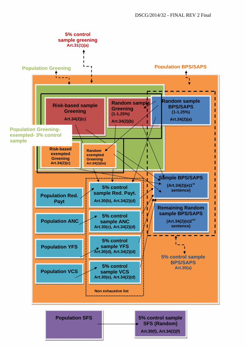
DSCG/2014/32 - FINAL REV 2 Final
d
Population BPS/SAPSPopulation Greening
Random sample Greening (1-1.25%)
Art.34(2)(b)
Random sample BPS/SAPS
(1-1.25%)
Art.34(2)(a)
Risk-based sample Greening Art.34(2)(c)
5% control sample BPS/SAPS
Art.30(a)
Population YFS
Population Red. Payt
Population VCS
Population SFS
5% control sample SFS (Random)
Art.30(f), Art.34(2)(f)
Population ANC
Sample BPS/SAPS (Art.34(2)(e)1st
sentence)
Remaining Random sample BPS/SAPS
(Art.34(2)(e)2nd sentence)
5% control sample YFS
Art.30(d), Art.34(2)(d)
5% control sample Red. Payt. Art.30(b), Art.34(2)(d)
5% control sample VCS
Art.30(e), Art.34(2)(d)
5% control sample ANC
Art.30(c), Art.34(2)(d)
Non exhaustive list
5% control sample greening
Art.31(1)(a)
Risk-based exempted Greening Art.34(2)(c)
Random exempted Greening Art.34(2)(ba)
Population Greening-exempted- 3% control sample
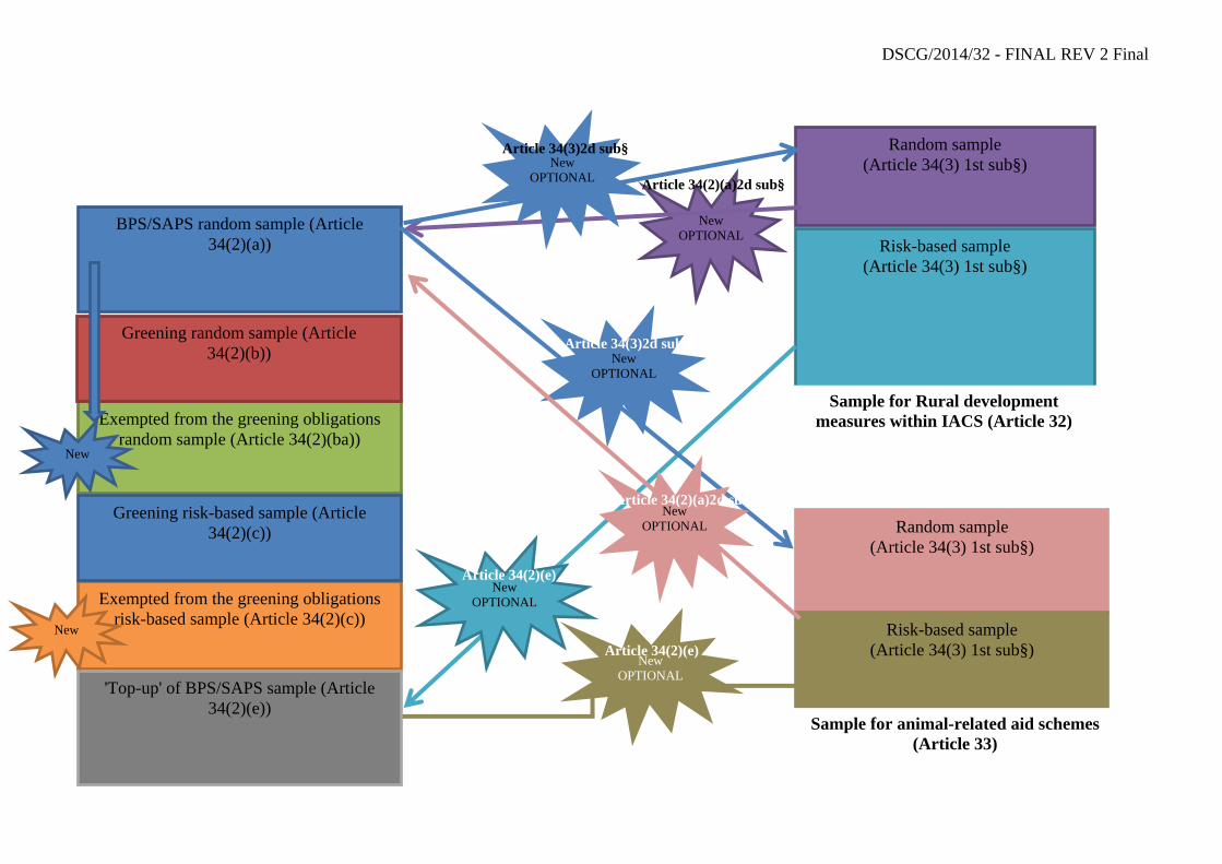
DSCG/2014/32 - FINAL REV 2 Final
Cascade sampling CY2016 and onwards
Random sample (Article 34(3) 1st sub§)
Risk-based sample (Article 34(3) 1st sub§)
New OPTIONAL
Random sample (Article 34(3) 1st sub§)
Risk-based sample (Article 34(3) 1st sub§)
Sample for Rural development measures within IACS (Article 32)
Sample for BPS/SAPS (Article 30(a))
Article 34(2)(a)2d sub§
New OPTIONAL
Article 34(2)(e)
BPS/SAPS random sample (Article 34(2)(a))
Exempted from the greening obligations random sample (Article 34(2)(ba))
Exempted from the greening obligations risk-based sample (Article 34(2)(c))
Greening risk-based sample (Article 34(2)(c))
'Top-up' of BPS/SAPS sample (Article 34(2)(e))
New
New
New OPTIONAL
Article 34(3)2d sub§
New OPTIONAL
Article 34(2)(a)2d sub§
New OPTIONAL
Article 34(3)2d sub§
Greening random sample (Article 34(2)(b))
New OPTIONAL
Article 34(2)(e)
Cascade sampling CY2016 and onwards
Sample for animal-related aid schemes (Article 33)
DSCG/2014/32 - FINAL REV 2 Final
ANNEX II
GUIDANCE FOR THE REPRESENTATIVENESS S OF THE RANDOM ON-THE-SPOT CHECKS (OTSC) FOR AREA-BASED MEASURES
This section is referred to as "Guidance for representative random sample''
The purpose of this section is to provide Member States (MS) with tips/suggestions on how to compile random samples so that their representativeness is reinforced. The current legislation foresees a fixed percentage of the random sample. Ensuring the randomness and representativeness of the OTSC check sample aims at a reported error rate that is more precise (i.e. better reflects the actual level of non-compliance).
1. LEGAL FRAMEWORK
1.1. General principles
1.1.1. Representativeness
Article 59(2) of Regulation (EU) No 1306/2013 stipulates that the random part of OTSC sample shall be drawn in such a way as to obtain a representative error rate. The requirement to have a representative error rate is also laid down in recital 33 of Commission Implementing Regulation (EU) No 809/2014.
1.1.2. Randomness
Article 34 of Regulation (EU) No 809/2014 sets out the general methodology for the selection of the control sample of Articles 30 (area-related aid schemes other than the greening payment) and Article 31 (greening). In the context of area-related aid schemes (direct payments), random sampling is compulsory for BPS/SAPS, greening payment, including beneficiaries exempted from greening and the small farmer schemes (Article 34(2)(a), (b), (ba) (f), (h), (ha) and (i)). In addition, the provisions of Article 34 (3) and (4) also refer to partial random selection.
The random sample permits an estimate of the background level of anomalies in the system. It supports decisions enacting the mechanism for increasing the control rate (in accordance with Art.35 of Regulation (EU) No 809/2014) and also permits an assessment of the effectiveness of the criteria being applied for risk analysis. In addition, the random samples are used in DG AGRI's assurance building through estimating the residual error rate which is reported in the Annual Activity Report of the DG.

DSCG/2014/32 - FINAL REV 2 Final
49
1.2. Representative vs Random concept
In order to achieve a representative error rate as required under the legal framework, both the representativeness and the randomness of the sample should be ensured.
Random sample means that every item in the population is chosen entirely by chance and has an equal chance of being selected.
Representative sample means the selected subset (sample) will accurately present the entire population and the obtained result is applicable to the entire population, i.e. the same result would have been obtained if the whole population was tested. For small populations (below 200 transactions), the statistical accuracy of the sample's results cannot be ensured. Although the sample selection should still be random, the statistical representativeness of small samples drawn from small populations is questionable.
2. SELECTION METHOD
The types of random sampling are explained in 1.3 and in 1.5.1 in the main document, as well as in 2.4.2 as far as the selection of parcels (and not beneficiaries) to be controlled is concerned.
3. DESIGNING THE SAMPLING
3.1. Define the objectives
The objectives of the sampling need to be defined beforehand so that the sampling is designed in such a manner so as to meet the primary objective(s). The primary objective should be for example: control of x% of beneficiaries for example applying under BPS for a given claim year in order to verify the compliance with all eligibility criteria (Article 24(1) of Regulation No 809/2014), as well as the effective functioning of the management and control systems and to establish a reliable error rate.
3.2. Define deviations (errors)
What constitutes a deviation should be clearly defined before the sampling and should be done per scheme taking into consideration the eligibility conditions for that particular scheme. For BPS, the deviations could be defined as follows:
- Eligible: yes or no
- Over declaration: how much (in hectares)?
For greening, there are more deviations that need to be considered in advance so that all of them are covered.
The elements of on-the-spots and the determination of areas referred to under section 2 above give for instance indications of what has to be checked and, consequently, of what possible deviations could be.
DSCG/2014/32 - FINAL REV 2 Final
50
3.3. Define the population
The population from which the sample will be selected should be appropriate for the specific objective as the sample results can be projected only to the population from which the sample was selected. It has to be done per scheme. Please also refer to section 1.1 of the main document above.
3.3.1. Check the completeness of the population
One of the main steps before selecting the sample is ensuring the completeness of the population. When extracting the data (number of beneficiaries and their attributes) from the system, it needs to be ensured that all beneficiaries are included in the extract. A simple test can be to compare the number of beneficiaries applying for the scheme (in the system) to the number of beneficiaries extracted. Attention should be paid to late submissions as well, so that they are also included in the population. Another test could be to check the sequence of the beneficiaries if they are numbered. If there are differences, they need to be reconciled before selecting the sample.
This does not however prevent Member States from making provisional samples before all applications have been submitted pursuant to Article 34(7) of Regulation (EU) No809/2014. In this case, that provisional sample shall be completed when all relevant aid applications or payment claims are available.
3.3.2. Define the period to be covered
A sample should be drawn from the entire claim year to which the results are to be applied. It should be verified that all admissible aid applications for a particular scheme are selected through setting the appropriate time frame. Late applications (if admissible) should also be included. See also section 3.3.1 regarding possibilities to make provisional samples or sampling in different steps.
3.3.3. Define the sampling unit
For the purposes of OTSC sampling, the sampling unit should be beneficiary found to be admissible or eligible for payment at the time of submission of the aid application or after administrative checks (Cf Article 34(1) of Regulation No809/2014), per scheme or RS zone.
For example, the population for 1% random sample for BPS should be all admissible beneficiaries for a particular claim year or all RS zones in the country.
3.3.4. Homogeneity of the population
An important aspect to be considered when preparing the X% random sample for a particular scheme is whether the population is relatively homogeneous. Homogeneity is the tendency of items in a population to be similar and, normally, there should be fewer exceptional items to skew the result. That is why, the population for

DSCG/2014/32 - FINAL REV 2 Final
51
the OTSC should be analysed in advance in order to see how homogeneous (or not) it is. A possible solution is stratifying the population. Possible stratifications could be:
- depending on the most suitable OTSC method- classical vs RS: depending on the geophysical particularities, some countries could define two strata: one stratum of intensive agriculture inside which random zones could be selected for RS checks and the other of more extensive agriculture (i.e. pastures mixed with non-agricultural features, commonages, alpine pastures) for which classical inspections would be used. Zones/regions should be defined in such a way that all beneficiaries applying for the particular scheme are considered and have an equal chance of being selected.
- per region: even if the OTSC method is the same (e.g. classical OTSC for the whole country), the OTSC population could be stratified per region, especially if the type of agriculture varies between regions or if the administration of OTSC is done at regional level. This could be done in view of having more objective results.
3.4. Determine the sampling selection method
Irrespective of the sampling selection method applied (as described in sections 1.2.2 and 1.5.1 of the main document), the selection needs to be unbiased. This could be achieved through the usage of software. If specific software is not available, Excel or www.random.org are possible means for random selections. The generated random numbers should be properly documents (through a print screen or a generated document that cannot be altered).
3.5. Determine the sample size
The size of the OTSC random samples is fixed in Regulation (EU) No 809/2014 per scheme.
Please note that the same principle is applied to all schemes, i.e. they can either have to be selected as part of the cascade sampling or, in some cases, they can either be part of the cascade or they can be selected independently. In addition, where the Regulation prescribes the type of sample (random or risk-based, or both with different weights) per scheme, this has to be respected.
In contrast to the paragraph above, when RS is used for OTSC, normally, the sample is based on the RS zones and only then, translated into number of beneficiaries.
MS are advised to select for OTSC a number of beneficiaries slightly higher than the one fixed in the Regulation so that the legal obligations for OTSC for the particular year are met without having to draw additional samples at a later stage if there appears to be a shortfall.
3.6. Perform the sample
After the sample has been designed and drawn, it could be useful to examine the selected items to determine if all of them are "valid": are all beneficiaries

DSCG/2014/32 - FINAL REV 2 Final
52
a priori admissible to participate in this scheme; are all RS images of the appropriate quality10, etc. If such “invalid” cases are present but the MS has selected a higher number than the one fixed in the legislation, there is no need to re-select items. However, if there is not enough buffer and an item has to be replaced with a new one, it should be selected in accordance with the original sampling requirement and applying whenever possible the same procedure.
3.7. Evaluating the sampling results
After completing the OTSC, the sample results should be compiled and evaluated:
- calculation of the error rate as reported in the control statistics;
- analysis of the deviations (systematic vs non-systematic11)
MS are advised to analyse the level and sources of errors in order to identify possible weaknesses in their OTSC methods or in IACS as a whole. Appropriate corrective measures should be taken in order to address those weaknesses.
3.8. Documenting the sampling procedure
All steps of the sampling procedure should be properly documented and the OTSC results should be fed into the system. Where necessary, LPIS updates should be triggered so that the pre-established information for the following year's aid application is up-to-date.
10 The quality of imagery in terms of ortho-rectification, radiometry, etc. should be ensured.
11 Non-systematic deviations or errors are the ones that are one-off errors and cannot be limited to a particular problem/event. In contrast, the systematic deviations/errors are often due to a problem which persists throughout a period of time.