on the prediction of channel heads in a complex alpine ...€¦ · on the prediction of channel...
TRANSCRIPT
On the prediction of channel heads in a complex alpine terrain usinggridded elevation data
Stefano Orlandini,1 Paolo Tarolli,2 Giovanni Moretti,1 and Giancarlo Dalla Fontana2
Received 11 June 2010; revised 19 November 2010; accepted 8 December 2010; published 23 February 2011.
[1] Threshold conditions for channel initiation are evaluated by using gridded elevationdata derived from a lidar survey, a reliable algorithm for the determination of surface flowpaths, and field observations of channel heads for a study area located in the eastern ItalianAlps. These threshold conditions are determined by considering the channel heads observedacross a portion of the study area and computing the related values of (1) drainage area A,(2) area-slope function AS2, with S being the local slope, and (3) Strahler order !� of surfaceflow paths extracted from gridded elevation data. Attention is focused on the dependence ofthe obtained threshold values on the size of grid cells involved and on the ability of theidentified threshold conditions to provide reliable predictions of channel heads across theentire study area. The results indicate that the threshold values of A, AS2, and !� are allsignificantly dependent on grid cell size, and the uncertainty in the determination ofthreshold values of !� is significantly smaller than that affecting the determination ofthreshold values of A and AS2. The comparison between predicted and observed channelheads indicates that the considered methods display variable reliability and sensitivity overdifferent drainage basins and grid cell sizes, with a general tendency to predict more channelheads than can be observed in the field. Acceptable predictions are normally obtained wherechannel heads are formed essentially by surface runoff. More comprehensive methods seem,however, to be needed to predict channel heads affected by groundwater seeping upward.
Citation: Orlandini, S., P. Tarolli, G. Moretti, and G. Dalla Fontana (2011), On the prediction of channel heads in a complex alpine
terrain using gridded elevation data, Water Resour. Res., 47, W02538, doi:10.1029/2010WR009648.
1. Introduction[2] The identification of the factors determining the loca-
tion and density of stream channels and valleys in drainagebasins is a perennial concern in geomorphology, with impli-cations for understanding of drainage basin origin, scaleand morphology, basin hydrology, and effects of naturaland man-induced process changes [Dunne and Leopold,1978, p. 694]. As pointed out by Howard [1994], some con-fusion has resulted from a failure to distinguish between the‘‘channel’’ (or ‘‘stream’’) network, defined by channels withwell-defined banks and sources, and the ‘‘valley’’ (or‘‘drainage’’) network, which is defined on the basis of basinmorphometry. The factors determining the locations ofchannel heads can be modeled by considering fluvial and/orlandsliding processes singly or in combination [Montgom-ery and Dietrich, 1988, 1989, 1992; Dietrich and Dunne,1993]. In contrast, valley networks result from the cumula-tive action of erosional processes over the longer timescalescommensurate with the evolution of the large-scale topogra-phy [Kirkby, 1993]. A network and its associated drainagedensity can be defined for either or both the channel and
valley system, but they are not equivalent. Attention isfocused in this study on the determination of the channelnetwork in grid-based digital elevation models.
[3] The channel network is the pattern of tributaries andmaster streams in a drainage basin as delineated on a plani-metric map [Leopold et al., 1964, p. 131]. In theory, thenetwork includes all the minor rills which are definite water-courses, even including all the ephemeral channels in the far-thest headwaters. In practice, the direct survey ofall channels is normally a prohibitive task, and headwardlimits of channels are often drawn to fit a personalized es-thetic rather than some well-defined hydrological or geomor-phological principle [Leopold, 1994, p. 228]. There is,therefore, a need for predictive methods incorporating theessential features of basin hydrology and geomorphologywhich may be used to provide detailed representations ofchannel networks based on a practicable number of fieldobservations. More specifically, these predictive methodsare needed to represent the channel network in grid-baseddigital elevation models, which are largely used in detailedsmall-scale catchment models [e.g., Orlandini and Rosso,1998; Camporese et al., 2010] and also in modern large-scale catchment models, where grid-based representations ofheadwaters are coupled with vector-based representations ofthe river network provided by hydrographic data sets (e.g.,C. H. David et al., River network routing on the NHDPlusdataset, submitted to Journal of Hydrometeorology, 2011.
[4] Although many studies addressing the prediction ofchannel heads have been presented in the literature [e.g.,
1Department of Mechanical and Civil Engineering, University of Mo-dena and Reggio Emilia, Modena, Italy.
2Department of Land and Agroforest Environments, University ofPadova, Padua, Italy.
Copyright 2011 by the American Geophysical Union.0043-1397/11/2010WR009648
W02538 1 of 12
WATER RESOURCES RESEARCH, VOL. 47, W02538, doi:10.1029/2010WR009648, 2011
Tribe, 1992; Montgomery and Foufoula-Georgiou, 1993;Ijjasz-Vasquez and Bras, 1995; Pilotti et al., 1996; Istan-bulluoglu et al., 2002; Kirkby et al., 2003; Hancock andEvans, 2005; McNamara et al., 2006], the problem ofpositioning channel heads in grid-based digital elevationmodels remains a challenge in computational hydrologyand geomorphology [e.g., Martz and Garbrecht, 1995;Imaizumi et al., 2010]. Most of the investigations carriedout in the last two decades were limited by the lack ofhigh-resolution digital elevation model data and fieldstudies necessary to map in detail the precise location ofchannel heads [Dietrich et al., 1993; Montgomery andFoufoula-Georgiou, 1993; Ijjasz-Vasquez and Bras, 1995].High-resolution data are now widely available as a reflec-tion of advances in the lidar (light detection and ranging)technology, and accurate flow direction methods have beendeveloped to fully exploit these data [e.g., Tarboton, 1997;Orlandini et al., 2003; Seibert and McGlynn, 2007]. Tech-nological advances in surveying and computation haverecently been used to identify the morphology of channelsdirectly from digital elevation model data [e.g., Lashermeset al., 2007; Tarolli and Dalla Fontana, 2009; Pirotti andTarolli, 2010; Passalacqua et al., 2010a, 2010b]. Methodsaiming to predict channel heads from nonlocal drainage ba-sin features remain, however, relevant to investigate theessential mechanisms governing channel head formationand to position channel heads in distributed catchmentmodels having limited grid resolution as a result of compu-tational constraints.
[5] Nonlocal methods for the prediction of channel headsin grid-based digital elevation models can be defined byconsidering different threshold conditions for channel ini-tiation. O’Callaghan and Mark [1984] and Tarboton et al.[1988] defined channel networks on a digital elevationmodel as those pixels that have an accumulated drainagearea A greater than some ‘‘threshold support area.’’ Mont-gomery and Dietrich [1988] proposed to use a threshold onthe monomial (product of nonnegative integer powers ofvariables) function AS2 of the drainage area A and the localslope S. The channel initiation function �AmSn, where � isa coefficient and m and n are real exponents, has been usedby other researchers [e.g., Willgoose et al., 1991]. Ijjasz-Vasquez and Bras [1995] noted that the related channel ini-tiation criterion can be equivalently stated by using thepower function ASk, with k ¼ n/m being a real exponent,and proposed a procedure for estimating k from the averagelocal slope versus drainage area scatterplot. Channel initia-tion functions AS2 and ASk are conceptually similar, andthe former does not require any parameter to be estimated.AS2 is, therefore, considered in preference to ASk in thepresent study. Peckham [1995] introduced a method basedon Horton’s [1945] and Strahler’s [1952, 1957] classifica-tion of surface flow paths extracted from digital elevationdata, in which exterior links having order !� smaller thanor equal to a given threshold are pruned.
[6] In the present study, these methods are evaluated byusing accurate field observations of channel heads collectedin the eastern Italian Alps [Pirotti and Tarolli, 2010],gridded elevation data obtained from lidar surveys [Cavalliet al., 2008; Tarolli and Dalla Fontana, 2009], and state-of-the-art methods for the delineation of drainage basinsand surface flow paths [Orlandini et al., 2003; Orlandini
and Moretti, 2009a, 2009b]. Threshold values of A, AS2, and!� are computed by considering the channel heads observedacross a portion of the study area. Attention is then focusedon critical issues that still remain to be explored, such as thedependence of threshold values on the size of grid cellsinvolved and the ability of the identified threshold conditionsto provide reliable predictions of channel heads across drain-age basins having different morphology.
2. Study Area[7] The study area is located in the Dolomites, a section
of the eastern Italian Alps. The centroid of this study areahas latitude 46�27051.9000N and longitude 12�6016.3700E Asshown in Figure 1, elevation ranges from 1935 to 2589 mabove sea level (asl), with an average of 2244 m asl. Theaverage terrain slope is 46%. The vegetation covers 97% ofthe area and consists of high-altitude grassland (91%) andsporadic tall forest (6%). The remaining 3% of the area isunvegetated talus deposits. The geological formationsinclude sandstones with calcareous-marly rock outcropsMoraines and scree deposits, and landslide accumulationsare also present. Soil thickness varies between 0.2 m ontopographic spurs and 1.5 m on topographic hollows [Borgaet al., 2002; Tarolli et al., 2008]. The soil thickness wasmeasured at 20 different locations across the study area. Ateach location, three soil thickness replicates 1–2 m apartwere collected by driving a 180 cm long sharpened steelrod graduated at 5 cm intervals vertically into the groundusing a pounder until refusal. The area has a typical alpineclimate with a mean annual rainfall of about 1100 mm. Pre-cipitation occurs mainly as snowfall from November toApril. During summer, storm events and long dry spells arecommon. Runoff is dominated by snowmelt in May andJune, but summer and early autumn floods represent an im-portant contribution to the flow regime. Although an exten-sive field campaign for the measurement of runoff has notbeen carried out so far, different surface runoff productionmechanisms have been observed to occur across the studyarea in response to rainfall and snowmelt events. Saturationexcess (Dunne) runoff occurs especially along valleys andchannels in response to long, low-intensity events, whereasinfiltration excess (Horton) runoff occurs across the wholedrainage basins in response to short, high-intensity events.No artificial structures are present in the headwaters of theselected study area, where channels develop their morphol-ogy in response to loads of water and sediments imposedon them, reflecting ultimately the natural interaction betweenclimate and geology.
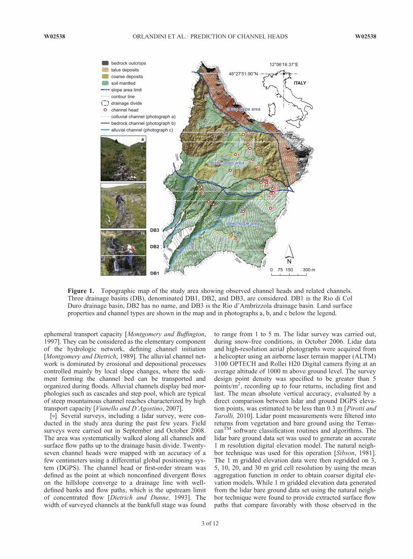
[8] Three drainage basins, denominated DB1, DB2, andDB3 in Figure 1, are considered. DB1 is the Rio di ColDuro drainage basin, DB2 has no name, and DB3 is the Riod’Ambrizzola drainage basin. All three drainage basins aresubbasins of the Rio Cordon drainage basin. The areas ofDB1, DB2, and DB3 are equal to 0.455, 0.081, and 0.708km2, respectively. Mean elevations are equal to 2199, 2132,and 2285 m asl, respectively. Mean slopes are equal to 49%,57%, and 42%, respectively. As shown in Figure 1, thechannels observed in the three drainage basins can beclassified as colluvial (photograph a), bedrock (photographb), and alluvial (photograph c) channels. The colluvial inci-sions are small headwater channels, exhibiting a weak or
W02538 ORLANDINI ET AL.: PREDICTION OF CHANNEL HEADS W02538
2 of 12
ephemeral transport capacity [Montgomery and Buffington,1997]. They can be considered as the elementary componentof the hydrologic network, defining channel initiation[Montgomery and Dietrich, 1989]. The alluvial channel net-work is dominated by erosional and depositional processescontrolled mainly by local slope changes, where the sedi-ment forming the channel bed can be transported andorganized during floods. Alluvial channels display bed mor-phologies such as cascades and step pool, which are typicalof steep mountainous channel reaches characterized by hightransport capacity [Vianello and D’Agostino, 2007].
[9] Several surveys, including a lidar survey, were con-ducted in the study area during the past few years. Fieldsurveys were carried out in September and October 2008.The area was systematically walked along all channels andsurface flow paths up to the drainage basin divide. Twenty-seven channel heads were mapped with an accuracy of afew centimeters using a differential global positioning sys-tem (DGPS). The channel head or first-order stream wasdefined as the point at which nonconfined divergent flowson the hillslope converge to a drainage line with well-defined banks and flow paths, which is the upstream limitof concentrated flow [Dietrich and Dunne, 1993]. Thewidth of surveyed channels at the bankfull stage was found
to range from 1 to 5 m. The lidar survey was carried out,during snow-free conditions, in October 2006. Lidar dataand high-resolution aerial photographs were acquired froma helicopter using an airborne laser terrain mapper (ALTM)3100 OPTECH and Rollei H20 Digital camera flying at anaverage altitude of 1000 m above ground level. The surveydesign point density was specified to be greater than 5points/m2, recording up to four returns, including first andlast. The mean absolute vertical accuracy, evaluated by adirect comparison between lidar and ground DGPS eleva-tion points, was estimated to be less than 0.3 m [Pirotti andTarolli, 2010]. Lidar point measurements were filtered intoreturns from vegetation and bare ground using the Terras-canTM software classification routines and algorithms. Thelidar bare ground data set was used to generate an accurate1 m resolution digital elevation model. The natural neigh-bor technique was used for this operation [Sibson, 1981].The 1 m gridded elevation data were then regridded on 3,5, 10, 20, and 30 m grid cell resolution by using the meanaggregation function in order to obtain coarser digital ele-vation models. While 1 m gridded elevation data generatedfrom the lidar bare ground data set using the natural neigh-bor technique were found to provide extracted surface flowpaths that compare favorably with those observed in the
Figure 1. Topographic map of the study area showing observed channel heads and related channels.Three drainage basins (DB), denominated DB1, DB2, and DB3, are considered. DB1 is the Rio di ColDuro drainage basin, DB2 has no name, and DB3 is the Rio d’Ambrizzola drainage basin. Land surfaceproperties and channel types are shown in the map and in photographs a, b, and c below the legend.
W02538 ORLANDINI ET AL.: PREDICTION OF CHANNEL HEADS W02538
3 of 12
field, the mean aggregation function was found to ensurean high degree of consistency between surface flow pathsextracted from gridded elevation data having differentresolutions.
3. Identification of Channel Heads[10] Surface flow paths are determined in this study by
using the D8-LTD (eight flow directions, least transversedeviation) single flow direction algorithm [Orlandini et al.,2003; Orlandini and Moretti, 2009a, 2009b]. The D8-LTDmethod performs a path-based analysis in which the devia-tions between steepest and possible flow directions areaccumulated along the path and not just evaluated at thelocal scale as done in the original D8 method proposed byO’Callaghan and Mark [1984]. In the D8-LTD method,transverse deviations are used in preference to angulardeviations since they were found to provide the most accu-rate determinations of surface flow paths [Orlandini et al.,2003; Orlandini and Moretti, 2009b]. Surface flow pathsare assumed in this study to occur along the slope lines,defined by Maxwell [1870] as those lines that intersect con-tour lines at right angles. Under this assumption, single flowdirection algorithms are preferred to multiple flow directionalgorithms such as those proposed by Quinn et al. [1991],Tarboton [1997], and Seibert and McGlynn [2007]. Orlan-dini and Moretti [2009a] show that the D8-LTD methodprovides a sound description of surface flow paths anddrainage areas. With respect to the simpler D8 method, theD8-LTD method solves the problem of aligned surfaceflow paths along slopes and therefore provides an accuratedetermination of surface flow paths and related classifica-tions in the small areas supporting the channel heads.
[11] Three methods for the automated identification andprediction of channel heads from gridded elevation data areevaluated. Each of these methods defines a threshold condi-tion for channel initiation and assumes that channels origi-nate where threshold exceedences occur. Thresholds aregiven in terms of (1) drainage area A as proposed byO’Callaghan and Mark [1984] and Tarboton et al. [1988],(2) monomial function of the drainage area A and localslope S of the kind AS2 as suggested by Montgomery andDietrich [1992], and (3) Strahler order !� of surface flowpaths extracted from gridded elevation data as proposed byPeckham [1995]. The drainage area A at a given cell iscomputed by accumulating local contributions along theupslope drainage system. The slope S at a given cell is eval-uated along the flow direction toward its downslope neigh-bor, and it is conventionally assumed to be positivedownward. A two-step procedure is used to determine thechannel network using method 3. In the first step, Strahlerclassification is applied to all surface flow paths of the digi-tal elevation model, including those generated at the sourcecells. A surface flow path order !� is assigned to each linkbetween a source and a junction or between junctions. Inthe second step, surface flow paths having an order lessthan or equal to a given threshold !�t are pruned. Theremaining surface flow paths are assumed to provide thepredicted channel network. Channel orders ! in theobtained channel network are computed as
! ¼ !� � !�t : ð1Þ
[12] Numerical experiments are carried out to investigatethe ability of the considered methods to identify and repro-duce observed channel heads. Special attention is paid tothe dependence of threshold conditions for channel initia-tion on the size of grid cells involved. Relationshipsexpressing the variation of threshold variables for channelinitiation with the grid cell size are determined by consider-ing the channel heads observed within DB1 and are thenapplied to the DB2 and DB3. Gridded elevation data havingcell sizes h equal to 1, 3, 5, 10, 20, and 30 m are consid-ered. For each of the 16 channel heads observed withinDB1 and for each grid cell size h, threshold drainage areaAt, area slope function (AS2)t, and Strahler order !�t aredetermined by considering surface flow paths obtainedfrom the D8-LTD flow direction algorithm. For any givengrid cell size, mean and standard deviation of the relatedthreshold variables are assumed to provide the best valuesand the average uncertainty connected to the estimation ofthese best values, respectively [Taylor, 1997, p. 101].Accordingly, these values are represented in Figure 2 asdata points and uncertainty bars, respectively. The bandsformed by connecting the end points of uncertainty bars areshaded in Figure 2 to highlight the uncertainty with whichthreshold conditions for channel initiation are determinedfrom field observations and gridded elevation data.
[13] Weighted least squares fitting is applied to determinethe relationships expressing the variations of threshold vari-ables with grid cell size [Taylor, 1997, p. 198]. Linear mod-els of the kind y ¼ a þ bx are used to describe the variationof threshold variables At and (AS2)t with grid cell size h,where y represents the variable At or (AS2)t, x represents thevariable h, and a and b are parameters. In addition, a linearmodel of the kind y ¼ a þ bx is also used to describe thesimple power function relationship !�t ¼ �h� between thethreshold variable !�t and the grid cell size h, where � and� are parameters, y ¼ log!�t , a ¼ log�, b ¼ �, and x ¼log h (logarithms are to base 10 throughout the paper).Weighted least squares fitting is applied to the six datapoints (xi, yi) (i ¼ 1, . . . , 6), which have different, knownuncertainties �i. The values of �i (i ¼ 1, . . . , 6) are com-puted by using the standard deviations of threshold varia-bles At, (AS2)t, and !�t , namely, �At , �ðAS2Þt , and �!�t , as�i ¼ �At , �i ¼ �ðAS2Þt , and �i ¼ logð!�t þ �!�t Þ � logð!�t�
�
�!�t Þ�=2, respectively [Orlandini et al., 2006]. The weightassociated with each data point (xi, yi) (i ¼ 1, . . . , 6) is thendetermined as wi ¼ 1=�2
i . It is remarked here that uncertain-ties �i in the determination of threshold variables yi arecomputed from observed channel heads and terrain attrib-utes extracted directly from gridded elevation data. As such,they incorporate the contributions to total uncertainty due toerrors in the positioning of observed channel heads, ingridded elevation data, and in terrain analysis methods, aswell as the inherent inaccuracy of the considered channelinitiation conditions. These different sources of uncertaintycan be evaluated separately by applying the uncertaintyanalysis methods described, for instance, by Orlandini et al.[2006]. This analysis is beyond the scope of the presentstudy.
[14] Predictive relationships for threshold variables areshown in Figure 2 and reported in Table 1 along with therelated correlation coefficients R, coefficients of determina-tion R2, and p values [Taylor, 1997, p. 218]. The results
W02538 ORLANDINI ET AL.: PREDICTION OF CHANNEL HEADS W02538
4 of 12

shown in Figures 2a and 2b reveal that threshold values At
and (AS2)t increase as the grid cell size h increases. Thelinear models reported in Table 1 display correlation coeffi-cients R equal to 0.961 and 0.978, coefficients of determi-nation R2 equal to 0.924 and 0.956, and p values equal to
0.0023 and 0.0007, respectively. As shown in Figure 2c, thethreshold value !�t is found to decrease as the grid cell size hincreases. The power function relationship reported in Table1, transformed logarithmically, displays a correlation coeffi-cient R equal to �0.997, a coefficient of determination R2
equal to 0.994, and a p value less than 0.0001. By denotingcorrelations as ‘‘highly significant’’ if p < 0.01, all the corre-lations reported in Figure 2 and Table 1 can be considered tobe highly significant [e.g., Taylor, 1997, p. 218].
[15] The significance of the computed threshold varia-bles At, (AS2)t, and !�t must be qualified by the accuracywith which surface flow paths are determined and terrainattributes are computed. Orlandini and Moretti [2009a]compared surface flow paths and catchment areas obtainedfrom several methods based on gridded elevation data usinga detailed contour and flow line network [Moretti andOrlandini, 2008] as a reference. The D8-LTD method wasfound to be equally or more accurate than other existingmethods, and the relationship
h � 0:15A0:4 ð2Þ
was found to provide the upper bound of grid cell size hthat should be considered in order to ensure type 2 relativeerrors E2 in the delineations of drainage basins having areaA are less than 10%. In the case of DB1 considered inFigure 2, headwaters have an area of the order of 4000 m2
(Figure 2a with h ¼ 1 m), and gridded elevation data withcell size not exceeding 4.1 m should be considered in orderto meet the requirement expressed by (2). Errors made byapplying the D8-LTD method to grid data with resolutionsof 1, 3, 5, 10, 20, and 30 m are equal to 2%, 7%, 11%, 23%,46%, and 68%, respectively, as given by E2 ^ 0.63 h/A0.4
with A ¼ 4000 m2 [Orlandini and Moretti, 2009a, p. 12].Nonetheless, in order to evaluate circumstances commonlyfound in geomorphological and hydrological applications,grid cell sizes greater than 4.1 m are considered. Values ofh exceeding 30 m are not considered owing to the accuracyissue reported above and also to the fact that At and !�tclearly tend to h2 and 1, respectively, as h increases.
[16] The results reported in Figure 2 and Table 1 provideindications of the ability of the methods to identify thresh-old values for channel initiation that are invariant over theconsidered channel heads and vary with the size of the gridcells involved in a predictable manner. These indicationsare expressed by standard deviations represented by uncer-tainty bars and by the coefficients of determination of pre-dictive relationships for threshold variables, respectively.However, these capabilities do not necessarily imply theability of methods to predict accurately the channel heads.In fact, well-identified threshold conditions can providepredictions of channel heads in locations where these headsdo not actually occur. In other words, as better explained insections 5 and 6, small uncertainty bars and good fits ofobserved data indicate that a method is sensitive (i.e., itdoes not produce false negatives), but it does not necessar-ily ensure that the model is reliable (i.e., it does not producefalse positives). In addition, the predictive capabilities ofthe considered relationships need to be evaluated for testcases that are not used for their determination. A morecomprehensive evaluation of the considered methods istherefore reported in sections 4 and 5.
Figure 2. Observed and predicted variations of thresholdvariables for channel initiation with grid cell size. Means(data points) and standard deviations (uncertainty bars) ofthreshold values of (a) drainage area A, (b) area-slope func-tion AS2, and (c) Strahler order of surface flow pathsextracted from gridded elevation data !�, computed on thechannel heads observed in DB1, are provided for each gridcell size h. Predictive relationships are obtained by weightedleast squares fitting.
Table 1. Relationships Between Threshold Variables for ChannelInitiation and Grid Cell Size
Relationshipa R R2 p
At ¼ 2806.61 þ 224.90h 0.961 0.924 0.0023(AS2)t ¼ 439.71 þ 23.46h 0.978 0.956 0.0007!�t ¼ 5:869h�0:282 �0.997 0.994 <0.0001
aAt (m2), threshold drainage area; (AS2)t (m2), threshold AS2 function;!�t (dimensionless), threshold Strahler order of surface flow paths; h (m),grid cell size.
W02538 ORLANDINI ET AL.: PREDICTION OF CHANNEL HEADS W02538
5 of 12
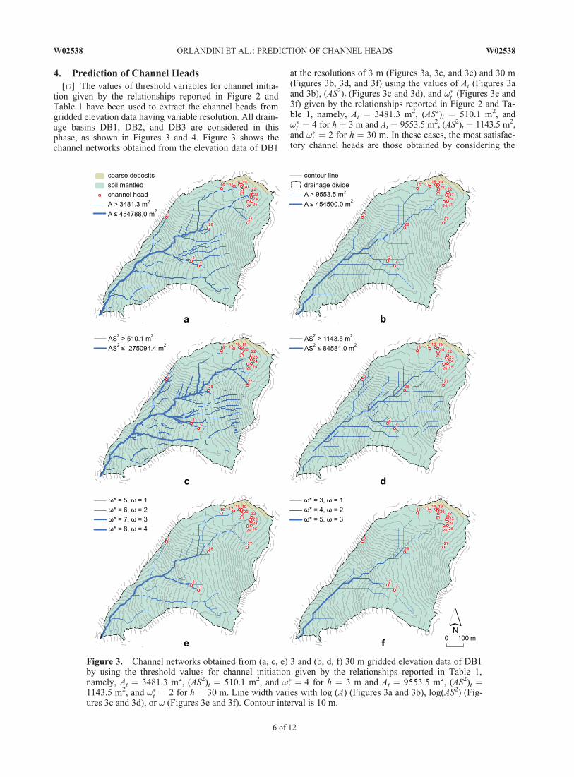
4. Prediction of Channel Heads[17] The values of threshold variables for channel initia-
tion given by the relationships reported in Figure 2 andTable 1 have been used to extract the channel heads fromgridded elevation data having variable resolution. All drain-age basins DB1, DB2, and DB3 are considered in thisphase, as shown in Figures 3 and 4. Figure 3 shows thechannel networks obtained from the elevation data of DB1
at the resolutions of 3 m (Figures 3a, 3c, and 3e) and 30 m(Figures 3b, 3d, and 3f) using the values of At (Figures 3aand 3b), (AS2)t (Figures 3c and 3d), and !�t (Figures 3e and3f) given by the relationships reported in Figure 2 and Ta-ble 1, namely, At ¼ 3481.3 m2, (AS2)t ¼ 510.1 m2, and!�t ¼ 4 for h ¼ 3 m and At ¼ 9553.5 m2, (AS2)t ¼ 1143.5 m2,and !�t ¼ 2 for h ¼ 30 m. In these cases, the most satisfac-tory channel heads are those obtained by considering the
Figure 3. Channel networks obtained from (a, c, e) 3 and (b, d, f) 30 m gridded elevation data of DB1by using the threshold values for channel initiation given by the relationships reported in Table 1,namely, At ¼ 3481.3 m2, (AS2)t ¼ 510.1 m2, and !�t ¼ 4 for h ¼ 3 m and At ¼ 9553.5 m2, (AS2)t ¼1143.5 m2, and !�t ¼ 2 for h ¼ 30 m. Line width varies with log (A) (Figures 3a and 3b), log(AS2) (Fig-ures 3c and 3d), or ! (Figures 3e and 3f). Contour interval is 10 m.
W02538 ORLANDINI ET AL.: PREDICTION OF CHANNEL HEADS W02538
6 of 12

Strahler classification of surface flow paths extracteddirectly from gridded elevation data and pruning the exte-rior links with orders less than or equal to !�t , with !�t ¼ 4for h ¼ 3 m (Figure 3e) and !�t ¼ 2 for h ¼ 30 m (Figure3f). The channel networks extracted using the thresholds Atand (AS2)t (Figures 3a– 3d) reproduce the observed chan-nels but also indicate many occurrences of channels inlocations where channels are not observed (Figure 1). Fig-
ure 4 shows the channel heads obtained from the elevationdata of DB2 (Figures 4a, 4c, and 4e) and DB3 (Figures 4b,4d, and 4f) at the resolution of 3 m, using the values of At(Figures 4a and 4b), (AS2)t (Figures 4c and 4d), and !�t(Figures 4e and 4f) given by the relationships reported inFigure 2 and Table 1, namely, At ¼ 3481.3 m2, (AS2)t ¼510.1 m2, and !�t ¼ 4. While the results obtained for DB2are satisfactorily consistent with those obtained for DB1,
Figure 4. Channel networks obtained from 3 m gridded elevation data of (a, c, and e) DB2 and (b, d,and f) DB3 by using the threshold values for channel initiation given by the relationships reported in Ta-ble 1, namely, At ¼ 3481.3 m2, (AS2)t ¼ 510.1 m2, and !�t ¼ 4. Line width varies with log(A) (Figures4a and 4b), log(AS2) (Figures 4c and 4d), or ! (Figures 4e and 4f). Contour interval is 10 m.
W02538 ORLANDINI ET AL.: PREDICTION OF CHANNEL HEADS W02538
7 of 12

the channel networks predicted for DB3 are generallymuch more developed than can be observed in the field(Figure 1). The inability of the examined methods to repro-duce the channel networks observed in DB3 is discussed insection 6.
5. Analysis of Quality[18] The quality of methods for the prediction of channel
heads is evaluated for all considered drainage basins andgrid cell sizes by computing two indexes of reliability andsensitivity. These two indexes are based on the binary clas-sification of predictions expressed in terms of true positives(TP), false positives (FP), and false negatives (FN). Assketched in Figure 5, circles having a fixed radius are drawnaround each observed channel head to define reasonableneighborhoods for them. A radius equal to the largest gridcell size considered in this study, namely, 30 m, is selected.TP are considered to be those predictions that fall within atleast one of the circles drawn around the observed channelheads. FP are considered to be those predictions that do notfall within any of the circles drawn around the observedchannel heads. FN are represented in this study by thosecircles drawn around the observed channel heads that donot contain any predictions. The reliability of a method,when applied to a given drainage basin, is defined as
r ¼P
TPP
TPþP
FP; ð3Þ
whereP
TP andP
FP are the total numbers of true andfalse positives, respectively. This index provides a measureof the method’s ability to not predict channel heads where
channel heads are not observed, that is, the ability to notgenerate false positives. The sensitivity of a method, whenapplied to a given drainage basin, is defined as
s ¼P
TPP
TPþP
FN; ð4Þ
whereP
TP andP
FN are the total numbers of true posi-tives and false negatives, respectively. This index providesa measure of the method’s ability to predict all observedchannel heads, that is, the ability to not allow for falsenegatives.
[19] A good method is reliable and sensitive. The varia-tions of r and s with the grid cell size h, obtained by apply-ing the considered methods to DB1, DB2, and DB3, arereported in Figure 6. The obtained values of r and s areclearly affected by the radius selected to define the neigh-borhoods of the observed channel heads. The resultsreported in Figure 6 (obtained by using a radius of 30 m)are, however, representative of the general patterns dis-played by the variations of r and s with h. It is specifiedhere that other indexes requiring the evaluation of true neg-atives, such as those used by Grabs et al. [2009], are notsuitable for the analysis reported in the present studybecause a definition of true negatives that is essentially in-dependent of grid cell size cannot be provided.
6. Discussion[20] The study area shown in Figure 1 represents a diffi-
cult case for the prediction of channel heads because it iscomposed of complex calcareous rocks forming high cliffsand various kinds of colluvial and alluvial deposits. In thesegeomorphological settings, channel heads are observed tooccur by surface erosion in response to water and sedimentloads released by upstream areas (channel heads 1 –7 and25 –28 in Figure 1), as well as by groundwater seepingupward at the base of rock cliffs where highly permeablefractured rocks interface with less permeable sediments(channel heads 8–24 in Figure 1). In order to evaluate thecapabilities of simple predictive models based on terrainattributes such as drainage area, local slope, and Strahler clas-sification of surface flow paths to identify and predict channelheads, no distinction between channel heads formed by sur-face runoff and by groundwater seeping upward is made apriori in the analysis reported in this paper. In addition, whileit is acknowledged that different surface runoff productionmechanisms (infiltration excess, saturation excess, and sub-surface stormflow returning upward) may coexist duringhigh-frequency rainfall events, infiltration excess is consid-ered to be the dominant surface runoff production mechanismduring the extreme rainfall events that determine the forma-tion of channel heads.
[21] The plots reported in Figure 2 display the variationsof threshold variables for channel initiation (At, (AS2)t, and!�t ) with grid cell size (h). For each grid cell size h, meanand standard deviation of the threshold variables associatedwith the 16 channel heads observed in DB1 are representedin the plots by data points and uncertainty bars, respec-tively, the latter having lengths equal to twice the standarddeviations. Standard deviations and related uncertainty barsprovide a measure of the uncertainty with which a unique
Figure 5. Sketch of the methodology used to determine abinary classification of predicted channel heads. Circleshaving a fixed radius are drawn around all the observedchannel heads. True positives (example labeled TP) arethose predictions falling within at least one of these circles.False positives (example labeled FP) are those predictionsthat do not fall in any of these circles. False negatives(example labeled FN) are represented in this study bycircles that do not contain any predicted channel heads.
W02538 ORLANDINI ET AL.: PREDICTION OF CHANNEL HEADS W02538
8 of 12

value of a threshold variable can be determined and used toreproduce channel heads across DB1. The uncertainty inthe determination of At is found to increase as h increasesand to display large values for h � 10 m (Figure 2a). Theuncertainty in the determination of (AS2)t is found to dis-play the highest values for h ¼ 1 m because of the high var-iability of local slope at that grid resolution and for h �20 m because of the increase of uncertainty in A observedwhen h increases (Figure 2b). The uncertainty in the deter-mination of !�t is relatively smaller than that found for Atand (AS2)t, and it does not vary significantly with grid cellsize h (Figure 2c). It is remarked here that uncertaintybands reported in Figure 2 indicate the dispersion of thresh-old values associated with observed channel heads and pro-vide a measure of the methods’ sensitivity as given byequation (4). They do not, however, provide any measureof the methods’ reliability given by equation (3).
[22] Mean values of At and (AS2)t are found to increasewith h (Figures 2a and 2b). These increases are likely to beconnected to the fact that larger areas are clearly drainedby larger cells associated with the observed channel heads.By considering the relationship At/h ¼ 2806.61/h þ 224.90derived from the first relationship reported in Table 1, itcan, however, be noted that the ratio At/h is not constant ;rather, it decreases with h, from 3031.5 m for h ¼ 1 m to318.5 m for h ¼ 30 m. It may, therefore, be concluded that
the area drained by the grid cells associated with channelhead locations increases with the cell size h in an unpre-dictable manner, certainly not at a constant rate, dependingon terrain morphology. The weaker increase of (AS2)t withh (line slope equal to 23.46 m in Table 1) with respect tothe increase of At with h (line slope equal to 224.90 m inTable 1) is likely to be connected to the decrease of thelocal slope S computed as h increases. Simple linear rela-tionships are found to reproduce satisfactorily the varia-tions of At and (AS2)t with h, providing coefficients ofdetermination R2 equal to 0.924 and 0.956, respectively(Figures 2a and 2b and Table 1). Mean values of !�t , associ-ated with the channel heads observed in DB1, are found todecrease with h (Figure 2c). This decrease is likely to beconnected to the decrease of the degree of branching in thenetwork formed by surface flow paths as grid cell size hincreases. A simple power function relationship is found toreproduce quite well the variation of !�t with h, providing acoefficient of determination R2 (computed by using varia-bles transformed logarithmically) equal to 0.994 (Figures2c and Table 1).
[23] Satisfactory predictions of channel heads in bothDB1 and DB2 are obtained by computing the Strahler clas-sification of surface flow paths and pruning the exteriorlinks (Figures 3e, 3f, and 4e). The comparison betweenchannel networks of DB1 obtained from 3 (Figure 3e) and
Figure 6. Indexes of quality representing the reliability, as given by equation (3), and the sensitivity,as given by equation (4), of predictive methods based on (a – c) drainage area A, (d – f) area-slope func-tion AS2, and (g – i) Strahler order !� in DB1, DB2, and DB3.
W02538 ORLANDINI ET AL.: PREDICTION OF CHANNEL HEADS W02538
9 of 12

30 m (Figure 3f) gridded elevation data reveals thatalthough high-resolution data provide more accurate pre-dictions of surface flow paths, channel heads can be pre-dicted reasonably well by also using low-resolution data,provided that the threshold !�t is selected in accordancewith the scaling relationship reported in Figure 2c andTable 1, namely, !�t ¼ 5:869h�0:282, which gives !�t ¼ 4for h ¼ 3 m and !�t ¼ 2 for h ¼ 30 m. The satisfactory pre-diction of the channel heads in DB2 provides a validationof the considered methods since the channel headsobserved in DB2 are not used for determining the variationof !�t with h reported in Figure 2c and Table 1. It is alsostressed that reliable methods for the prediction of channelheads are those that reproduce channel heads observed inthe field (true positive) and do not indicate the occurrenceof channel heads that are not observed in the field (falsepositive). Under this perspective, the methods based onthreshold values of A and AS2 are found to provide less reli-able predictions of channel across DB1 and DB2 (Figures3a –3d, 4a, and 4c).
[24] The poorer predictive capabilities of methods basedon the thresholds At and (AS2)t over that based on the thresh-old !�t are likely related to two factors. First, it may benoted that the drainage area A is an indicator of the amountof water and sediments released to a given location, but itclearly does not incorporate the factors connected to theshape of the drainage basin. The Strahler order !�, instead,incorporates these factors since it generally increases withthe size of the drainage basin, and for a fixed size, it islarger in drainage basins with the higher Horton’s [1932]form factor, the latter being defined as the ratio of the areaof the drainage basin and square of drainage basin length.Among drainage basins having a fixed area A, those display-ing a higher Strahler order and form factor are likely tohave a smaller time of concentration tc and thus to release ahigher peak flow discharge QT with return period T. Thiscan be explained by considering the simple rational formula
QT ¼ �iT ðtcÞA; ð5Þ
where � is the runoff coefficient of the drainage basin andiT(tc) is the average intensity of the rainfall event withduration equal to the time of concentration tc and returnperiod T. Since iT(tc) increases as tc decreases, higher QT isproduced by drainage basins with lower tc. In addition, con-vective cells producing extreme rainfall events in shortdurations, comparable with the times of concentration ofdrainage basins contributing to channel heads, normallydisplay a small extension in space and are therefore morelikely to affect entirely drainage basins with high form fac-tors. Hence, the higher flow discharges released by drain-age basins having area A are likely to occur for thosedrainage basins having the smallest times of concentration,a higher form factor, and higher surface flow path Strahlerorder !�t . It is stressed here that this discussion is based onthe assumption that infiltration excess is the dominant sur-face runoff production mechanism for extreme rainfallevents determining the formation of channel heads.
[25] The second factor is the high variability of localslope S. While the threshold (AS2)t has been theoreticallyjustified and extensively verified in the field [e.g., Mont-gomery and Dietrich, 1989], its applicability to the auto-
mated identification of channel heads suffers from thelimitations connected to the use of the drainage area men-tioned above and to the high variability of computed valuesof the local slope S. The use of more robust estimates of theslope S compared to those obtained from the local analysisof terrain data is an issue that needs to be considered infuture investigations. Although a more comprehensive vali-dation of the assumptions made may be carried out, the dis-cussion reported here provides a reasonable explanation forthe reason why numerous channels are predicted using thethresholds At and (AS2)t in areas of DB1 and DB2, wherelong, nearly parallel flow paths occur, while these channelsare not predicted using the threshold !�. In these cases, theincrease in the drainage area A does not imply an increasein surface flow path order !� and does not represent thepropensity of the area to release water and sediments.
[26] Inaccurate predictions of channel networks areobtained in DB3 (Figures 4b, 4d, and 4f). All methodsunder consideration overestimate the extension of the chan-nel network. The method based on the threshold (AS2)t
appears to provide the best results since it does not repro-duce a clear channel network in the NW part of the drainagebasin, where channels are not observed to occur. It is, how-ever, specified here that only the drainage system elementsfor which AS2 > 510.1 m2 are drawn in Figure 4d, and anextended channel network could be shown in Figure 4d, aswell as in Figures 3c, 3d, and 4c, by representing the fullextension of channels originating in the uppermost locationswhere the threshold (AS2)t is exceeded. More importantly,as highlighted by the geological characterization reported inFigures 1 and 4d, a strong control of geology on the forma-tion of channel heads is exercised in DB3, implying thatchannel heads observed in that drainage basin are essen-tially produced by groundwater seeping upward and notonly by surface runoff. Such processes affecting the forma-tion of channel heads can hardly be reproduced by consider-ing simple geomorphometric variables such as A, S, and !�
and need to be investigated in future works by consideringdetailed hydrologic models of surface-subsurface flow inter-action, such as that developed by Camporese et al. [2010].
[27] The analysis of quality shown in Figures 5 and 6provides a view of the methods’ reliability r and sensitivitys as evaluated over the three drainage basins considered(DB1, DB2, and DB3) and the grid cell sizes considered (1,3, 5, 10, 20, and 30 m). One can note that the values of rand s given by equations (3) and (4), respectively, displayrather low values even when the related channel networksare visually satisfactory. For instance, for the channel net-work shown in Figure 3e, r ¼ 0.259 and s ¼ 0.467 (Figure6g). In most of the cases, the sensitivity s is found to displayhigher values compared to the reliability r, indicating thatthe considered methods generate more channel heads withrespect to those that can actually be observed in the field.This is an issue that needs to be acknowledged in drainagebasin hydrology. Because channel flow velocity is normally1 order of magnitude higher than overland flow velocity, anoverestimation of the channel network extension implies anunderestimation of the time of concentration and, as given,for instance, by equation (5), an overestimation of the peakdischarge released. The reliability of methods is found tovary significantly with the considered drainage basin. InFigure 6, the values of r obtained for DB1 and DB2 are
W02538 ORLANDINI ET AL.: PREDICTION OF CHANNEL HEADS W02538
10 of 12

greater than those obtained for DB3 (e.g., Figures 6g–6i).The results shown in Figure 6 do not seem to support theuse of one method over the others. It may only be observedthat the method based on the Strahler classification providesthe best results for certain drainage basins and grid cellsizes, but the other two simpler methods provide smoothervariations of r and s with the grid cell size and may there-fore be considered to be more robust in that respect.
7. Conclusions[28] The ability of threshold conditions for channel initia-
tion to identify and predict observed channel heads wasevaluated (Figure 1). The threshold conditions consideredwere defined in terms of (1) drainage area At, (2) area-slopefunction (AS2)t, and (3) Strahler order of surface flow pathsextracted from gridded elevation data !�t . By computingthreshold values from field observations and gridded eleva-tion data, it was found that (1) At, (AS2)t, and !�t are all sig-nificantly dependent on grid cell size, (2) uncertainty in thedetermination of !�t is significantly smaller than that affect-ing the determination of At and (AS2)t, and (3) !�t followsquite well a power function relationship of grid cell size(Figure 2 and Table 1). It was, however, shown that predic-tive methods based on well-identified threshold conditionsmay be expected to be sensitive but not necessarily reliable(equations (3) and (4), Figure 5). In fact, the consideredmethods were all found to display variable reliability andsensitivity over drainage basins having different morphologyand grid cell sizes, with a general tendency to predict morechannel heads than can be observed in the field (Figures 3,4, and 6). In addition, the case of DB3 revealed that the con-sidered threshold conditions are unable to predict accuratelythe observed channel heads in areas where geology andgroundwater seeping upward exercise important controls onchannel initiation (Figures 1, 4, and 6). The case study pre-sented in this paper provides an in-depth, yet limited, assess-ment of our capabilities to predict channel heads across acomplex area. Although acceptable predictions are obtainedwhere channel heads are formed essentially by surface run-off, more comprehensive methods incorporating the surface-subsurface flow interaction appear to be needed to advanceour scientific understanding of the formation of channelheads and to improve the reliability with which the channelnetwork is represented in distributed catchment models.
[29] Acknowledgments. This study was carried out under the researchprograms PRIN 2005 (grant 2005072101) and PRIN 2008 (grant2008A7EBA3) funded by the Italian Ministry of Education, University,and Research. Part of the resources used in this work was provided by theInterdepartmental Research Center for Cartography, Photogrammetry,Remote Sensing and GIS at the University of Padova (CIRGEO). Theauthors are grateful to the Associate Editor and the anonymous reviewersfor comments that led to improvements in the manuscript.
ReferencesBorga, M., G. Dalla Fontana, and F. Cazorzi (2002), Analysis of topo-
graphic and climatic control on rainfall-triggered shallow landslidingusing a quasi-dynamic wetness index, J. Hydrol., 268(1 –4), 56–71,doi:10.1016/S0022-1694(02)00118-X.
Camporese, M., C. Paniconi, M. Putti, and S. Orlandini (2010), Surface-subsurface flow modeling with path-based runoff routing, boundary con-dition-based coupling, and assimilation of multisource observation data,Water Resour. Res., 46, W02512, doi:10.1029/2008WR007536.
Cavalli, M., P. Tarolli, L. Marchi, and G. Dalla Fontana (2008), The effec-tiveness of airborne lidar data in the recognition of channel bed morphol-ogy, Catena, 73(3), 249– 260, doi:10.1016/j.catena.2007.11.001.
Dietrich, W. E., and T. Dunne (1993), The channel head, in Channel Net-work Hydrology, edited by K. Beven and M. J. Kirkby, pp. 175–219,John Wiley, New York.
Dietrich, W. E., C. J. Wilson, D. R. Montgomery, and J. McKean (1993),Analysis of erosion thresholds, channel networks, and landscape mor-phology using a digital terrain model, J. Geol., 101(2), 259–278.
Dunne, T., and L. B. Leopold (1978), Water in Environmental Planning,818 pp., W. H. Freeman, New York.
Grabs, T., J. Seibert, K. Bishop, and H. Laudon (2009), Modeling spatialpatterns of saturated areas: A comparison of the topographic wetnessindex and a dynamic distributed model, J. Hydrol., 373(1– 2), 15–23,doi:10.1016/j.jhydrol.2009.03.031.
Hancock, G. R., and K. G. Evans (2005), Channel head location and charac-teristics using digital elevation models, Earth Surf. Process. Landforms,31(7), 809– 824, doi:10.1002/esp.1285.
Horton, R. E. (1932), Drainage basin characteristics, Eos Trans. AGU, 13,350– 361.
Horton, R. E. (1945), Erosional development of streams and their drainagebasins: Hydrophysical approach to quantitative morphology, Geol. Soc.Am. Bull., 56(3), 275– 370.
Howard, A. D. (1994), A detachment-limited model of drainage basin evo-lution, Water Resour. Res., 30(7), 2261– 2285.
Ijjasz-Vasquez, E. J., and R. L. Bras (1995), Scaling regimes of local slopeversus contributing area in digital elevation models, Geomorphology,12(4), 299– 311, doi:10.1016/0169-555X(95)00012-T.
Imaizumi, F., T. Hattanji, and Y. S. Hayakawa (2010), Channel initiationby surface and subsurface flows in a steep catchment of the AkaishiMountains, Japan, Geomorphology, 115(1– 2), 32– 42, doi:10.1016/j.geomorph.2009.09.026.
Istanbulluoglu, E., D. G. Tarboton, R. T. Pack, and C. Luce (2002), A prob-abilistic approach for channel initiation, Water Resour. Res., 38(12),1325, doi:10.1029/2001WR000782.
Kirkby, M. J. (1993), Long term interactions between networks and hill-slopes, in Channel Network Hydrology, edited by K. Beven and M. J.Kirkby, pp. 255–293, John Wiley, New York.
Kirkby, M. J., L. J. Bull, J. Poesenc, J. Nachtergaelec, and L. Vandekerck-hove (2003), Observed and modelled distributions of channel and gullyheads—With examples from SE Spain and Belgium, Catena, 50(2– 4),415– 434, doi:10.1016/S0341-8162(02)00128-5.
Lashermes, B., E. Foufoula-Georgiou, and W. E. Dietrich (2007), Channelnetwork extraction from high resolution topography using wavelets,Geophys. Res. Lett., 34, L23S04, doi:10.1029/2007GL031140.
Leopold, L. B. (1994), A View of the River, Harvard Univ. Press, Cam-bridge, Mass.
Leopold, L. B., M. G. Wolman, and J. P. Miller (1964), Fluvial Processesin Geomorphology, W. H. Freeman, San Francisco, Calif.
Martz, L. W., and J. Garbrecht (1995), Automated recognition of valleylines and drainage networks from grid digital elevation models: A reviewand a new method—Comment, J. Hydrol., 167(1– 4), 393–396.
Maxwell, J. C. (1870), On hills and dales, London Edinburgh DublinPhilos. Mag. J. Sci., 4/40(269), 421– 425.
McNamara, J. P., A. D. Ziegler, S. H. Wood, and J. B. Vogler (2006), Chan-nel head locations with respect to geomorphologic thresholds derivedfrom a digital elevation model: A case study in northern Thailand, For.Ecol. Manage., 224(7), 147–156.
Montgomery, D. R., and J. M. Buffington (1997), Channel-reach morphol-ogy in mountain drainage basins, Geol. Soc. Am. Bull., 109(5), 596– 611.
Montgomery, D. R., and W. E. Dietrich (1988), Where do channels begin?,Nature, 336(6196), 232– 234.
Montgomery, D. R., and W. E. Dietrich (1989), Source areas, drainage den-sity and channel initiation, Water Resour. Res., 25(8), 1907–1918.
Montgomery, D. R., and W. E. Dietrich (1992), Channel initiation and theproblem of landscape scale, Science, 255(5046), 826– 830.
Montgomery, D. R., and E. Foufoula-Georgiou (1993), Channel networksource representation using digital elevation models, Water Resour. Res.,29(12), 3925– 3934.
Moretti, G., and S. Orlandini (2008), Automatic delineation of drainagebasins from contour elevation data using skeleton construction techni-ques, Water Resour. Res., 44, W05403, doi:10.1029/2007WR006309.
O’Callaghan, J., and D. M. Mark (1984), The extraction of drainage net-works from digital elevation data, Comput. Vision Graphics Image Pro-cess., 28(3), 323–344.
W02538 ORLANDINI ET AL.: PREDICTION OF CHANNEL HEADS W02538
11 of 12

Orlandini, S., and G. Moretti (2009a), Determination of surface flowpaths from gridded elevation data, Water Resour. Res., 45, W03417,doi:10.1029/2008WR007099.
Orlandini, S., and G. Moretti (2009b), Comment on ‘‘Global search algo-rithm for nondispersive flow path extraction’’ by Kyungrock Paik, J.Geophys. Res., 114, F04004, doi:10.1029/2008JF001193.
Orlandini, S., and R. Rosso (1998), Parameterization of stream channel ge-ometry in the distributed modeling of catchment dynamics, WaterResour. Res., 34(8), 1971– 1985.
Orlandini, S., G. Moretti, M. Franchini, B. Aldighieri, and B. Testa (2003),Path-based methods for the determination of nondispersive drainagedirections in grid-based digital elevation models, Water Resour. Res.,39(6), 1144, doi:10.1029/2002WR001639.
Orlandini, S., C. Boaretti, V. Guidi, and G. Sfondrini (2006), Field determi-nation of the spatial variation of resistance to flow along a steep Alpinestream, Hydrol. Processes, 20(18), 3897– 3913, doi:10.1002/hyp.6163.
Passalacqua, P., T. D. Trung, E. Foufoula-Georgiou, G. Sapiro, and W. E.Dietrich (2010a), A geometric framework for channel network extractionfrom lidar: Nonlinear diffusion and geodesic paths, J. Geophys. Res.,115, F01002, doi:10.1029/2009JF001254.
Passalacqua, P., P. Tarolli, and E. Foufoula-Georgiou (2010b), Testingspace-scale methodologies for automatic geomorphic feature extractionfrom lidar in a complex mountainous landscape, Water Resour. Res., 46,W11535, doi:10.1029/2009WR008812.
Peckham, S. D. (1995), Self-similarity in the three-dimensional geometryand dynamics of large river basins, Ph.D. thesis, Univ. of Colo., Boulder.
Pilotti, M., C. Gandolfi, and G. B. Bischetti (1996), Identification and anal-ysis of natural channel networks from digital elevation models, EarthSurf. Processes Landforms, 21(11), 1007– 1020.
Pirotti, F., and P. Tarolli (2010), Suitability of lidar point density andderived landform curvature maps for channel network extraction,Hydrol. Processes, 24(9), 1187– 1197, doi:10.1002/hyp.7582.
Quinn, P., K. Beven, P. Chevallier, and O. Planchon (1991), The predictionof hillslope flow paths for distributed hydrological modeling using digitalterrain models, Hydrol. Processes, 5(1), 59– 80.
Seibert, J., and B. L. McGlynn (2007), A new triangular multiple flow direc-tion algorithm for computing upslope areas from gridded digital elevationmodels, Water Resour. Res., 43, W04501, doi:10.1029/2006WR005128.
Sibson, R. (1981), A brief description of natural neighbor interpolation, inInterpreting Multivariate Data, edited by V. Barnett, pp. 21–36, JohnWiley, Chichester, U. K.
Strahler, A. N. (1952), Hypsometric (area-altitude) analysis of erosional to-pology, Geol. Soc. Am. Bull., 63(11), 1117– 1142.
Strahler, A. N. (1957), Quantitative analysis of watershed geomorphology,Eos Trans. AGU, 8(6), 913– 920.
Tarboton, D. G. (1997), A new method for the determination of flow direc-tions and upslope areas in grid digital elevation models, Water Resour.Res., 33(2), 309– 319.
Tarboton, D. G., R. L. Bras, and I. Rodriguez-Iturbe (1988), The fractal na-ture of river networks, Water Resour. Res., 24(8), 1317–1322.
Tarolli, P., and G. Dalla Fontana (2009), Hillslope-to-valley transition mor-phology: New opportunities from high resolution DTMs, Geomorphol-ogy, 113(1– 2), 47– 56, doi:10.1016/j.geomorph.2009.02.006.
Tarolli, P., M. Borga, and G. Dalla Fontana (2008), Analyzing the influenceof upslope bedrock outcrops on shallow landsliding, Geomorphology,93(3-4), 186–200, doi:10.1016/j.geomorph.2007.02.017.
Taylor, J. R. (1997), An Introduction to Error Analysis: The Study ofUncertainties in Physical Measurements, Univ. Sci. Books, Sausalito,Calif.
Tribe, A. (1992), Automated recognition of valley lines and drainage net-works from grid digital elevation models: A review and a new method, J.Hydrol., 139(1-4), 263– 293.
Vianello, A., and V. D’Agostino (2007), Bankfull width and morphologicalunits in an alpine stream of the dolomites (northern Italy), Geomorphol-ogy, 83(3– 4), 266– 281, doi:10.1063/1.2825070.
Willgoose, G., R. L. Bras, and I. Rodriguez-Iturbe (1991), A coupled chan-nel network growth and hillslope evolution model: 1. Theory, WaterResour. Res., 27(7), 1671– 1684.
G. Dalla Fontana and P. Tarolli, Department of Land and Agroforest Envi-ronments, University of Padova, Agripolis, Viale dell’Universita 16, I-35020Padova, Italy. ([email protected]; [email protected])
G. Moretti and S. Orlandini, Department of Mechanical and Civil Engineer-ing, University of Modena and Reggio Emilia, Via Vignolese 905, I-41125Modena, Italy. ([email protected]; [email protected])
W02538 ORLANDINI ET AL.: PREDICTION OF CHANNEL HEADS W02538
12 of 12